District Watershed Development Unit, Tonk IWMP-IV - Directorate of ...
District Watershed Development Unit, Tonk IWMP-IV - Directorate of ...
District Watershed Development Unit, Tonk IWMP-IV - Directorate of ...

You also want an ePaper? Increase the reach of your titles
YUMPU automatically turns print PDFs into web optimized ePapers that Google loves.
Transect walk were carried out involving the community for Social mapping, Resource<br />
mapping. Detailed discussions and deliberations with all the primary stakeholders were carried<br />
out.<br />
Socio-economic survey was carried out during Apr to Sep. 2010 period covering all the<br />
households and primary data on demography, Land holdings, Employment status, Community<br />
activities etc. was collected as mentioned in chapter 2.<br />
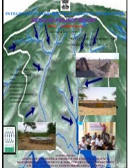
State remote sensing department was assigned the work <strong>of</strong> preparing various<br />
thematic layers using Cartosat-1 and LISS-3 imageries for Creation, development and<br />
management <strong>of</strong> geo-spatial database depicting present conditions <strong>of</strong> land (terrain), water and<br />
vegetation with respect to watershed under different ownerships at village level<br />
Various thematic layers provided by SRSAC are :<br />
• Delineation <strong>of</strong> Macro/Micro watershed boundaries.<br />
• Digitised Khasara maps <strong>of</strong> the villages falling in project area.<br />
• Network <strong>of</strong> Drainage lines, existing water bodies, falling in the project area.<br />
• Base maps (transport network, village/boundaries, and settlements).<br />
• Land Use / Land cover map.<br />
• Contours at 1 meter interval, slope map<br />
.<br />
Based on GIS thematic layers, Field visits , PRA and analysis <strong>of</strong> benchmark data (as<br />
discussed in chapter 2) final Treatment plan on revenue map for implementation has been<br />
framed. Thus each intervention identified has been marked on revenue map (map enclosed<br />
in DPR as annexure------).The GIS based intervention map, PRA based intervention map are<br />
annexed as ------.