Steep Tussock and Scree Slopes
Steep Tussock and Scree Slopes
Steep Tussock and Scree Slopes

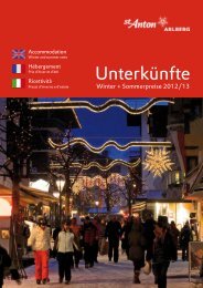
You also want an ePaper? Increase the reach of your titles
YUMPU automatically turns print PDFs into web optimized ePapers that Google loves.
<strong>Steep</strong> <strong>Tussock</strong> <strong>and</strong> <strong>Scree</strong> <strong>Slopes</strong><br />
Memminger Hut – Ansbacher Hut<br />
ALPInE ROuTE sEGMEnT A22<br />
APPROXIMATE HIKInG TIME<br />
VERTIcAL RIsE/VERTIcAL DROP<br />
DIsTAncE<br />
TRAIL RATInG<br />
DIFFIcuLTY RATInG<br />
TRAIL cHARAcTERIsTIcs<br />
FEATuREs<br />
6 hours<br />
cOuRsE steep descent from Memminger<br />
Hut into Parseiertal Valley, partly steep<br />
ascent across Langkar cirque to<br />
Grießlscharte notch, short gentle descent,<br />
short climb to Winterjoch saddle, short<br />
descent, gentle ascent to Kopfscharte<br />
notch, gentle descent to Ansbacher Hut.<br />
TRAIL DEscRIPTIOn Make your way down<br />
Trailhead: 2242m, End: 2376m; Total Elevation Gain: 1000m,<br />
Total Elevation Loss: 850m; Top Elevation: 2632m (Grießlscharte)<br />
10km<br />
Mountain Footpath, black<br />
Advanced, this hike should only be attempted by those who are sure footed<br />
<strong>and</strong> comfortable on unstable ground; suitable for children ages 14 <strong>and</strong> up<br />
Footpaths <strong>and</strong> singletrack trails (some sections have permanently fixed<br />
cables for protection)<br />
nature, History<br />
from Memminger Hut on a narrow, loamy <strong>and</strong><br />
in wet conditions slippery singletrack trail,<br />
which directly <strong>and</strong> steeply descends across<br />
tussock slopes <strong>and</strong> heads towards Parseiertal<br />
Valley. Thereafter, the path traverses<br />
(tussock) slopes (several times across<br />
gorges) <strong>and</strong> then further descends<br />
southwards into Parseiertal Valley (steel<br />
wire ropes in the lower section). The first<br />
section mostly runs across sloping terrain.<br />
1 // ADLERWEG TIROL /MEMMInGER HuT – AnsbAcHER HuT/ sEGMEnT A22
On the other side of the valley, a perfectly<br />
defined singletrack trail begins a gradual<br />
ascent through a grove before ascending<br />
more steeply across meadows. Thereafter,<br />
you get to Langkar cirque. On the right side<br />
of the cirque (in late summer next to the<br />
snowfield), a well-defined singletrack trail<br />
(with hardly any rubble) gradually ascends.<br />
Later, the trail steepens <strong>and</strong> bears left.<br />
Finally, climb up across a kind of chimney<br />
with fixed cables up to Grießlscharte notch.<br />
This section running on earthy soil is quite<br />
steep <strong>and</strong> can be slippery in wet conditions.<br />
A short descent is followed by a short <strong>and</strong><br />
steep counter-ascent up <strong>and</strong> over to<br />
Winterjoch saddle (just below Winterjoch<br />
saddle, Augsburger Höhenweg Trail branches<br />
off). From Winterjoch saddle, the trail<br />
descends for a short distance over scree<br />
slopes, passes behind stierkopf Mountain,<br />
<strong>and</strong> resumes its climb up to Kopfscharte<br />
notch across rugged terrain. From the notch,<br />
the path traverses tussock slopes <strong>and</strong> finally<br />
heads southwards to Ansbacher Hut with<br />
easy ups <strong>and</strong> downs.<br />
KEY POInTs narrow tiny ravine on the<br />
descent into Parseiertal Valley; schafgufel<br />
Hut (accommodation for shepherds) in a cave<br />
below Langkar cirque; impressively towering<br />
blankaspitze Peak south below Ansbacher<br />
Hut<br />
sPEcIAL ATTRAcTIOns<br />
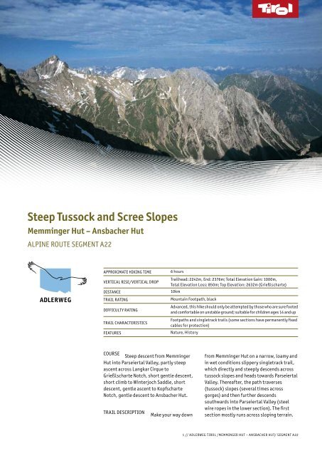
Trailhead View from Memminger Hut<br />
over Parseiertal Valley<br />
across Langkar cirque to<br />
Grießlscharte notch <strong>and</strong> to<br />
impressive Freispitze Peak<br />
north of it with its almost<br />
perpendicular rock faces,<br />
view of Parseierspitze Peak<br />
On the Trail crossing of Grießlscharte<br />
notch, reddish-brown iron<br />
deposits in the rocks next<br />
to the notch (particularly in<br />
the rocks of Rotspitze<br />
Peak); view from the notch<br />
back to Memminger Hut<br />
with its steep grass flanks<br />
below <strong>and</strong> to Verwall<br />
Mountain Range with Hoher<br />
Riffler Mountain in the<br />
south<br />
At the End View from Winterjoch<br />
saddle to dem<strong>and</strong>ing<br />
Augsburger Höhenweg<br />
Trail, linking Augsburger<br />
Hut with Ansbacher Hut,<br />
<strong>and</strong> running across the<br />
mountain flanks east of the<br />
saddle <strong>and</strong> east of Grießltal<br />
Valley<br />
HIGHLIGHTs<br />
Trailhead Pristine <strong>and</strong> remote<br />
Parseiertal Valley<br />
On the Trail Winterjoch saddle offers<br />
stunning views to the<br />
glacial field of Vordersee<br />
spitze Peak, Wetterspitze<br />
Peak, Feuerspitze Peak with<br />
its reddish-brown iron<br />
deposits, Arlberg Mountain<br />
Range with Valluga<br />
Mountain, remote<br />
Knappenboden Area north<br />
of stierkopf Mountain,<br />
Alperschontal Valley <strong>and</strong><br />
Allgäu Alps<br />
At the End Ansbacher Hut affords<br />
2 // ADLERWEG TIROL /MEMMInGER HuT – AnsbAcHER HuT/ sEGMEnT A22
Eateries/Accommodations<br />
Memminger Hütte<br />
(open late June<br />
through late September)<br />
T +43.5634.20036<br />
Ansbacher Hütte<br />
(open early July<br />
through late September)<br />
T +43.664.143 10 09<br />
Tourist Information<br />
Lechtal Valley<br />
www.lechtal.at<br />
St. Anton am Arlberg<br />
www.stantonamarlberg.com<br />
excellent views from Zuckerhütl Mountain to<br />
Arlberg Mountain Range (including the first<br />
mountains of the Province of Vorarlberg),<br />
down across stanzertal Valley <strong>and</strong> to striking<br />
Hoher Riffler Mountain on the opposite side<br />
<strong>and</strong> to impressively towering Eisenspitze<br />
Peak in the east<br />
nATuRAL scEnERY Mountain meadows,<br />
alpine pastures, wildflower displays, sparse<br />
forest (stone pines, larches), dwarf pines,<br />
rock outcrops, scree slopes, cirques,<br />
snowfields, sheep<br />
FEATuREs<br />
nATuRAL FEATuREs<br />
mountain flanks<br />
Iron deposits in the<br />
HIsTORIcAL FEATuREs Historic iron mining<br />
in the area around Knappenboden (west of<br />
Winterjoch saddle)<br />
sEnsORY EXPERIEncEs<br />
solitude <strong>and</strong> silence<br />
in Parseiertal Valley<br />
THEME Across notches <strong>and</strong> saddles<br />
OTHER HIKInG TRAILs Augsburger<br />
Höhenweg Trail (dem<strong>and</strong>ing, branches off<br />
from Lechtaler Höhenweg Trail east of<br />
Winterjoch saddle)<br />
LATERAL EnTRY A taxi service is operating<br />
between bach in Lechtal Valley <strong>and</strong> Madau; a<br />
trail <strong>and</strong> a path wind from Madau to<br />
Memminger Hut (3 hours’ ascent, 2½ hours’<br />
descent); a path links Flirsch <strong>and</strong> schnann<br />
with Ansbacher Hut (3 hours’ ascent, 3<br />
hours’ descent); a trail <strong>and</strong> a path wind from<br />
Madau to Ansbacher Hut (4 hours’ ascent, 3<br />
hours’ descent)