

Broomfield Local Area Plan - Fingal County Council
Broomfield Local Area Plan - Fingal County Council
Broomfield Local Area Plan - Fingal County Council

Create successful ePaper yourself
Turn your PDF publications into a flip-book with our unique Google optimized e-Paper software.
<strong>Broomfield</strong><br />
<strong>Local</strong> <strong>Area</strong> <strong>Plan</strong><br />
February 2010
<strong>Broomfield</strong><br />
<strong>Local</strong> <strong>Area</strong> <strong>Plan</strong><br />
February 2010<br />
CouNTy MANAGER<br />
David O’Connor<br />
DIRECToR oF SERVICES<br />
Gilbert Power<br />
SENIoR PLANNER<br />
Seán Ó Faircheallaigh<br />
REPoRT PREPARED By<br />
Nicholas O’Kane<br />
Sarah Ryan<br />
PLANNING<br />
DEPARTMENT<br />
PL09-0002
Table of Contents<br />
Executive Summary 1<br />
Vision Statement 4<br />
Introduction 5<br />
Location of LAP Lands 5<br />
Pre-Draft Public Consultation, Strategic Environmental 5<br />
Assessment Screening, Appropriate Assessment Screening 5<br />
<strong>Plan</strong>ning Context 8<br />
National <strong>Plan</strong>ning Policy 8<br />
Regional <strong>Plan</strong>ning Guidance 11<br />
<strong>Local</strong> <strong>Plan</strong>ning Guidance 11<br />
Location and Physical Context 14<br />
Location and Physical Context 14<br />
Landscape and Visual Analysis 14<br />
Trees and Hedgerows to be Retained 15<br />
Architectural and Cultural Heritage 15<br />
Transportation and Accessibility 16<br />
<strong>Local</strong> Service Provision 17<br />
Key Opportunities and Constraints 18<br />
5.0 Development Principles 20<br />
5.1 Land Use 20<br />
5.2 Character <strong>Area</strong>s 20<br />
6.0 Residential Density and Quantum 25<br />
6.1 Residential Density 25<br />
6.2 Residential Quantum 25<br />
7.0 Transport and Movement 26<br />
7.1 Transport and Movement Objectives 26<br />
7.2 Transportation Context 28<br />
7.3 Public Transport 28<br />
7.4 Pedestrian and Cycle Routes 29<br />
7.5 Surrounding Road Improvements 29<br />
7.6 Internal Movements 32<br />
7.7 Car Parking 32<br />
<strong>Fingal</strong> <strong>County</strong> <strong>Council</strong><br />
8.0 open Space 33<br />
Open Space Objectives 33<br />
Introduction 35<br />
Open Space Strategy 35<br />
Development <strong>Plan</strong> Open Space Requirements 36<br />
Class 1 Public Open Space 36<br />
Class 2 Public Open Space 37<br />
<strong>Broomfield</strong> LAP February 2010
Class 3 Open Space 37<br />
Private Open Space 38<br />
Retention of Trees 38<br />
urban Form and Design 39<br />
Urban Form and Design Objectives 39<br />
General Concept 41<br />
Principal Design Objectives 41<br />
Layout and Urban Form 42<br />
Residential Mix: Unit Types 43<br />
Residential Mix: Unit Sizes 44<br />
Building Heights 44<br />
Phasing of Development 45<br />
Housing Strategy (Part V) 45<br />
Construction Waste Management 45<br />
10.0 Services 48<br />
10.1 Foul Drainage 48<br />
10.2 Surface Water Drainage 49<br />
10.3 Sustainable Urban Drainage 49<br />
10.4 Water Quality 50<br />
10.5 Flood Risk Assessment 51<br />
10.6 Water Supply 51<br />
10.7 Electricity 51<br />
10.8 Gas 52<br />
10.9 Broadband 52<br />
11.0 Energy Efficiency and Sustainability 53<br />
11.1 Energy and Sustainability Objectives 53<br />
11.2 Introduction 53<br />
11.3 Sustainability and Building Design 54<br />
11.4 Housing Design Standards 54<br />
11.5 Building Energy Rating (BER) 55<br />
11.6 Waste Management 55<br />
11.7 Waste Recycling Requirements 56<br />
11.8 Water Conservation 56<br />
<strong>Broomfield</strong> LAP Design Guidance Matrix 57<br />
Appendices<br />
Appendix A Pre-Draft Public Consultation And Submissions Received<br />
Appendix B Strategic Environmental Screening Report<br />
Appendix C Appropriate Assessment Screening Report<br />
<strong>Fingal</strong> <strong>County</strong> <strong>Council</strong><br />
<strong>Broomfield</strong> LAP February 2010
EXECuTIVE SuMMARy<br />
BRooMFIELD LoCAL AREA PLAN<br />
The <strong>Local</strong> <strong>Area</strong> <strong>Plan</strong> provides a six-year development strategy for the RS1 lands at <strong>Broomfield</strong>,<br />
Malahide, as identified in the 2005-2011 <strong>Fingal</strong> Development <strong>Plan</strong>. Objective RS1 is ‘to provide<br />
for new residential communities in accordance with approved local area plans and subject to<br />
the provision of the necessary social and physical infrastructure’.<br />
The total site area is 30.7 hectares comprising open fields in agricultural use and a number of<br />
established dwellings. The northern part of the lands front onto Back Road and include detached<br />
dwellings on large sites together with the former grounds of Malahide Rugby Football Club.<br />
There is also an ESB sub-station located within these lands. The southern part of the lands<br />
contain no buildings and are separated from Kinsealy Lane by an undeveloped area zoned for<br />
residential use and existing dwellings fronting onto Kinsealy Lane. There are no protected<br />
structures or national monuments on the LAP lands nor is any part of it subject to an<br />
environmental designation. There are significant lines of trees and hedgerows on the lands<br />
which are identified in the LAP for protection. The <strong>Local</strong> <strong>Area</strong> <strong>Plan</strong> has the benefit of good access<br />
to bus and train links serving Malahide, the city centre and further afield. Malahide Castle<br />
Demesne is located opposite the LAP lands on Back Road.<br />
The <strong>Local</strong> <strong>Area</strong> <strong>Plan</strong> adopts a sensitive approach to development that will conserve, retain and<br />
enhance notable aspects of the natural environment. Great care has been taken to preserve<br />
and highlight the existing features of note within the lands while allowing for the growth of a<br />
new residential community at <strong>Broomfield</strong>.<br />
Key Principles of the <strong>Local</strong> <strong>Area</strong> <strong>Plan</strong><br />
Establishment of Distinctive Character <strong>Area</strong>s<br />
<strong>Fingal</strong> <strong>County</strong> <strong>Council</strong><br />
The design guidance within the <strong>Local</strong> <strong>Area</strong> <strong>Plan</strong> has been set down through the means of<br />
designating Character <strong>Area</strong>s, which respect the individual character of their immediate environs.<br />
There are three individual Character <strong>Area</strong>s identified, as follows:<br />
l The Northern <strong>Area</strong><br />
l The Southern <strong>Area</strong><br />
1<br />
<strong>Broomfield</strong> LAP February 2010
l The Consolidation <strong>Area</strong><br />
<strong>Fingal</strong> <strong>County</strong> <strong>Council</strong><br />
The sub-division of the overall <strong>Local</strong> <strong>Area</strong> <strong>Plan</strong> allows for the urban design, landscape guidance<br />
and access and movement strategies to be tailored to the characteristics of each individual area.<br />
Number of New Residential units<br />
The RS1 zoning on the northern part of the LAP lands indicates a gross density of 10 units per<br />
hectare. There is no density set out in the Development <strong>Plan</strong> for the southern portion. A density<br />
of 20 units per hectare is considered appropriate for this area, having regard to the character of<br />
nearby development. The LAP lands could therefore potentially accommodate 380 units in total.<br />
Access to Sustainable Modes of Transport<br />
The <strong>Local</strong> <strong>Area</strong> <strong>Plan</strong> is well placed to provide good access to sustainable modes of public<br />
transport, including bus routes running along the Malahide Road and The Hill and the nearby<br />
DART station at Malahide. The <strong>Local</strong> <strong>Area</strong> <strong>Plan</strong> provides for the establishment of new pedestrian<br />
and cycle routes and the upgrading of existing footpaths in order to provide both north-south<br />
and east-west connections.<br />
Retention of Architectural and Natural Heritage<br />
Malahide Demesne is a designated Architectural Conservation <strong>Area</strong> and <strong>Area</strong> of Sensitive<br />
Landscape. New development in the <strong>Local</strong> <strong>Area</strong> <strong>Plan</strong> will be designed so as to be sympathetic<br />
to the character and setting of the Architectural Conservation <strong>Area</strong>.<br />
Archaeological Heritage<br />
An archaeological assessment has been carried out and does not indicate the presence of<br />
archaeological features. However there are a number of Recorded Monuments located a short<br />
distance from the LAP lands. Archaeological monitoring will therefore be required at planning<br />
and construction stages.<br />
Roads Improvement Works<br />
As part of the development occurring within the <strong>Local</strong> <strong>Area</strong> <strong>Plan</strong> upgrading works will occur on<br />
Kinsealy Lane and Back Road. Pedestrian movement will also be facilitated along Kinsealy Lane<br />
by the provision of a new section of footpath. Pedestrian facilities at the road over the rail bridge<br />
on Back Road will be upgraded.<br />
Existing Residential Amenity<br />
It is a major objective of this <strong>Local</strong> <strong>Area</strong> <strong>Plan</strong> to secure the protection of the residential amenity<br />
of existing dwellings in the area.<br />
2<br />
<strong>Broomfield</strong> LAP February 2010
<strong>Fingal</strong> <strong>County</strong> <strong>Council</strong><br />
SuDS Strategy<br />
Sustainable urban drainage systems will be provided as a means of managing surface water<br />
drainage. A buffer zone will be provided along the Sluice Stream at the south of the LAP.<br />
Phasing Arrangements<br />
Phasing of the development is related to the need for adequate infrastructure and services to<br />
be in place. The improved pedestrian facility at the railway bridge on Back Road shall be<br />
implemented in the first phase of development.<br />
Amenities and Facilities<br />
Class 2 public open space is to be provided within the <strong>Local</strong> <strong>Area</strong> <strong>Plan</strong>. The adjacent Malahide<br />
Demesne will provide Class 1 public open space for the LAP. Financial contributions will be<br />
accepted in lieu of the provision of Class 1 public open space within the LAP. A neighbourhood<br />
centre is proposed as part of the LAP, which will be prioritised as part of the phasing process.<br />
3<br />
<strong>Broomfield</strong> LAP February 2010
1.0 VISIoN STATEMENT<br />
<strong>Fingal</strong> <strong>County</strong> <strong>Council</strong><br />
The vision for the LAP lands is to create a sustainable residential community with a character<br />
appropriate to its unique location. The design concept is derived from the existing natural<br />
features, in particular the mature trees and landscape elements. The LAP lands also benefit<br />
from proximity to Malahide Demesne, the amenity value of which can be maximised through the<br />
provision of safe pedestrian and cycle connections to and from the LAP lands.<br />
A sustainable mix of residential densities and house types shall be provided in order to create a<br />
series of distinct character areas and public open spaces defined by existing natural landscape<br />
features. These areas shall be linked by pedestrian and cycle routes which will connect the<br />
subject lands to adjoining areas, local schools and services, Malahide Demesne and Village.<br />
4<br />
<strong>Broomfield</strong> LAP February 2010
2.0 INTRoDuCTIoN<br />
2.1 Location of LAP lands<br />
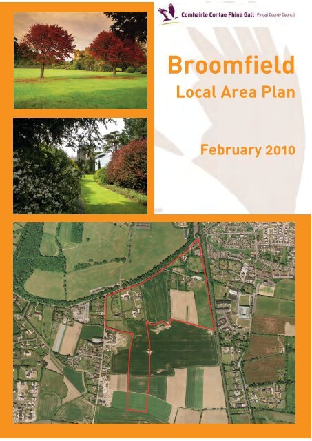
The <strong>Broomfield</strong> <strong>Local</strong> <strong>Area</strong> <strong>Plan</strong> concerns an area of 30.7 hectares located south of Malahide<br />
Demesne and west of the Dublin – Belfast railway line. Its location is shown on Map No. 1 -<br />
Location Map and Map 2 - Site Map. The northern boundary of the lands adjoin Back Road and<br />
the lands will be accessed via both Back Road and Kinsealy Lane.<br />
2.2 Pre-Draft Public Consultation, Strategic Environmental Assessment Screening, Appropriate<br />
Assessment Screening<br />
Pre-draft public consultation was undertaken between 19th September 2007 and 31st October<br />
2007. A number of submissions were received and these are included in Appendix 1. Regard was<br />
had in the drafting of this <strong>Local</strong> <strong>Area</strong> <strong>Plan</strong> to the submissions received.<br />
Strategic Environmental Assessment (SEA) screening, pursuant to the <strong>Plan</strong>ning and<br />
Development (Strategic Environmental Assessment) Regulations 2004 has been undertaken.<br />
The assessment concluded that SEA is not required in respect of the <strong>Broomfield</strong> <strong>Local</strong> <strong>Area</strong> <strong>Plan</strong>.<br />
A copy of the SEA Screening Report is attached as Appendix 2.<br />
Appropriate Assessment (AA) screening in accordance with Article 6 of the EU Habitats Directive<br />
(92/43/EEC) has been undertaken. The assessment concluded that AA is not required in respect<br />
of the <strong>Broomfield</strong> <strong>Local</strong> <strong>Area</strong> <strong>Plan</strong>. A copy of the AA Screening Report is attached as Appendix 3.<br />
The Department of Environment, Heritage and <strong>Local</strong> Government, the Department of<br />
Communications, Energy and Natural Resources and the Environmental Protection Agency were<br />
contacted during Strategic Environmental Assessment Screening and Appropriate Assessment<br />
Screening. Comments received have been incorporated into the <strong>Local</strong> <strong>Area</strong> <strong>Plan</strong>.<br />
This LAP shall remain in force for a period of six years from the date of adoption.<br />
5<br />
<strong>Fingal</strong> <strong>County</strong> <strong>Council</strong><br />
<strong>Broomfield</strong> LAP February 2010
3.0 PLANNING CoNTEXT<br />
3.1 National <strong>Plan</strong>ning policy<br />
The National Spatial Strategy (2002 - 2020)<br />
The National Spatial Strategy (NSS) is a twenty year planning framework designed to deliver<br />
more balanced social, economic and physical development between regions in Ireland. It<br />
provides a national framework and policy guidance for the implementation of regional, county<br />
and city plans. In order to drive development in the eight regions in Ireland the NSS proposes<br />
that areas of sufficient scale and critical mass will be built up through a network of ‘gateways’,<br />
‘hubs, and ‘development centres’.<br />
The concept of balanced regional development is central to the NSS. One of the broad aims of<br />
the document is to sustain Dublin’s central role in the economy. In relation to the Greater Dublin<br />
<strong>Area</strong>, within which <strong>Broomfield</strong> is located, the strategy notes that in order for balanced regional<br />
development, the performance of the Greater Dublin <strong>Area</strong> should be built upon and physically<br />
consolidated. The NSS also seeks the effective integration of land use and transportation policy<br />
within the spatial structure of the Greater Dublin <strong>Area</strong>.<br />
National Heritage <strong>Plan</strong> (2002)<br />
The National Heritage <strong>Plan</strong> sets out the framework for the protection and enhancement of all<br />
aspects of Ireland’s heritage which includes its natural heritage. One of the key concepts<br />
underlying this plan is ‘placing heritage at the heart of public life’. The plan sets a framework<br />
within which priority actions can be taken for the benefit of heritage.<br />
Transport 21 (2006)<br />
Transport 21 is a transport capital investment framework for the period 2006 – 2015. Its primary<br />
aim is to address the twin challenges of past investment backlogs and continuing growth in<br />
transport demand.<br />
The projects and programmes that make up Transport 21 will aim to:<br />
l Increase accessibility;<br />
l Ensure sustainability;<br />
l Expand capacity;<br />
l Increase use, and<br />
l Enhance quality.<br />
8<br />
<strong>Fingal</strong> <strong>County</strong> <strong>Council</strong><br />
<strong>Broomfield</strong> LAP February 2010
Transport 21 has helped, or is helping, to fund several projects in the vicinity of <strong>Broomfield</strong>, such<br />
as the M1 and M50 motorway upgrade works and investment in bus and rail based public<br />
transport in the Greater Dublin <strong>Area</strong>.<br />
As part of Transport 21, the Metro North line has been identified for funding, with the new line<br />
scheduled for completion by 2013. Using underground, surface and elevated tracks, Metro North<br />
will operate from St. Stephen’s Green, via Dublin Airport, to Belinstown, north of Swords. An<br />
estimated 35 million passengers a year will travel on this service, with trains every four minutes,<br />
increasing to every two minutes as the demand builds. The journey time from Bellinstown to St.<br />
Stephen’s Green will be 30 minutes. The nearest Metro stop to the <strong>Broomfield</strong> lands is approx.<br />
6.7 km away at Fosterstown.<br />
Sustainable Residential Development in urban <strong>Area</strong>s – Guidelines for <strong>Plan</strong>ning Authorities<br />
(2008).<br />
The Guidelines set down standards for delivering appropriately designed residential<br />
development. With relevance to the <strong>Local</strong> <strong>Area</strong> <strong>Plan</strong>, the document continues to reinforce the<br />
view on retaining the open character of certain lands, but where these are to be redeveloped,<br />
concentrating increased densities in appropriate selected locations.<br />
urban Design Manual – A Best Practice Guide (February 2008)<br />
<strong>Fingal</strong> <strong>County</strong> <strong>Council</strong><br />
This Manual is a companion document to Sustainable Residential Development in Urban <strong>Area</strong>s<br />
– Guidelines for <strong>Plan</strong>ning Authorities. The Guidelines fit with and cross-reference this Urban<br />
Design Manual in such a way that the user can easily visualise the desired outcomes and study<br />
potential solutions based on best practice experiences here in Ireland and across Europe. The<br />
two documents are intended to be read together with one complementing the other.<br />
Delivering Homes, Sustaining Communities and Quality Housing for Sustainable Communities<br />
(2007)<br />
‘Delivering Homes, Sustaining Communities’ was launched in February 2007. It sets out a range<br />
of actions aimed primarily at building sustainable communities and responding effectively to<br />
housing need as well as more effective delivery of housing programmes. The Guidelines identify<br />
the principles and criteria that are important in the design of housing. They highlight specific<br />
design features, requirements and standards that are particularly relevant to the <strong>Broomfield</strong><br />
area.<br />
‘Quality Housing for Sustainable Communities’ (2007) assists in the implementation of the<br />
9<br />
<strong>Broomfield</strong> LAP February 2010
policies set out in the above document. The document makes practical recommendations on<br />
more specific design issues, such as the layout and orientation of new homes through to detailed<br />
design elements, such as electricity socket provision in new residential developments.<br />
Architectural Heritage Protection Guidelines for <strong>Plan</strong>ning Authorities (2004)<br />
The Guidelines set out the requirements and procedures for planning authorities to establish<br />
and maintain a Record of Protected Structures, and to designate Architectural Conservation<br />
<strong>Area</strong>s. General best practice conservation principles are outlined, along with various criteria and<br />
development control standards in respect of projected structures. A number of key principles<br />
are explained, including the determination of the extent of ‘curtilage’ and ‘attendant grounds’.<br />
Guidance is provided on how the application of building, fire and access regulations may be<br />
balanced with the desire and need to conserve historic buildings and their fabric.<br />
<strong>Plan</strong>ning System and Flood Risk Management (2008)<br />
The Flood Risk Management Guidelines require the planning system at national, regional and<br />
local levels to:<br />
1) Avoid development in areas at risk of flooding by not permitting development in flood risk<br />
areas, particularly floodplains, unless there are fully justified wider sustainability grounds for<br />
appropriate development and unless the flood risk can be managed to an acceptable level<br />
without increasing flood risk elsewhere and where possible, reducing flood risk overall;<br />
2) Adopt a sequential approach to flood risk management based on avoidance, reduction and<br />
then mitigation of flood risk as the overall framework for assessing the location of new<br />
development in the development planning processes; and,<br />
3) Incorporate flood risk assessment into the process of decision making on planning applications<br />
and planning appeals.<br />
The guidelines support the use of flood risk assessments and management and the use of<br />
Sustainable Urban Drainage Systems (SUDS) within development, in order to assess, minimise<br />
and mitigate against flooding.<br />
Childcare Facilities Guidelines for <strong>Plan</strong>ning Authorities (2001)<br />
<strong>Fingal</strong> <strong>County</strong> <strong>Council</strong><br />
The Childcare Facilities Guidelines provide a framework to guide local authorities in the for<br />
mulation of development plan policy and also to guide developers and their designers in<br />
developing proposals for childcare facilities.<br />
10<br />
<strong>Broomfield</strong> LAP February 2010
3.2 Regional <strong>Plan</strong>ning Guidance<br />
Regional <strong>Plan</strong>ning Guidelines for the Greater Dublin <strong>Area</strong> (2004- 2016)<br />
The Regional <strong>Plan</strong>ning Guidelines provide the statutory framework for the future development<br />
of the Greater Dublin <strong>Area</strong>. The overall strategy divides the Greater Dublin <strong>Area</strong> into a<br />
‘Metropolitan’ and a ‘Hinterland’ area. Malahide is located within the Metropolitan area. The<br />
current population of Malahide is 14,937 (CSO, 2006), which confers a status of Moderate Growth<br />
Town (i.e. towns having a population of 10,000-20,000).<br />
<strong>Broomfield</strong> is located within the Metropolitan <strong>Area</strong> as defined in the Regional <strong>Plan</strong>ning<br />
Guidelines. The Strategy for the Metropolitan <strong>Area</strong> is to consolidate development and increase<br />
densities within it. This objective is tempered by a need to respect the established context and<br />
type of the built/urban form. Any new development in the <strong>Broomfield</strong> LAP area will require the<br />
delivery of a well designed residential environment which respects the existing built<br />
environment.<br />
3.3 <strong>Local</strong> <strong>Plan</strong>ning Guidance<br />
<strong>Fingal</strong> Development <strong>Plan</strong> (2005 -2011)<br />
The existing zoning of the lands are illustrated on Map 3 - <strong>Fingal</strong> Development <strong>Plan</strong> Extract.<br />
The land within the <strong>Local</strong> <strong>Area</strong> <strong>Plan</strong> area is zoned objective RS1 in the <strong>Fingal</strong> Development <strong>Plan</strong><br />
2005 – 2011, the stated objective of which is:<br />
‘To provide for new residential communities in accordance with approved local area plans<br />
and subject to the provision of the necessary social and physical infrastructure.’ (Table<br />
4.12 <strong>Fingal</strong> Development <strong>Plan</strong>).<br />
The <strong>Council</strong>’s stated vision, allied to this objective, set out in Table 4.12 of the Development <strong>Plan</strong>,<br />
is as follows:<br />
‘to ensure the provision of high quality new residential environments with good layouts<br />
and design, with adequate public transport and cycle links and within walking distance<br />
of community facilities; to provide an appropriate mix of houses sizes, types and tenures<br />
in order to meet household needs and to promote balanced communities.’<br />
11<br />
<strong>Fingal</strong> <strong>County</strong> <strong>Council</strong><br />
<strong>Broomfield</strong> LAP February 2010
There is a Specific Objective for the northern part of the <strong>Local</strong> <strong>Area</strong> <strong>Plan</strong> area:<br />
‘To provide for residential development at a residential density of 10 dwellings per<br />
hectare.’<br />
The southern part of the <strong>Local</strong> <strong>Area</strong> <strong>Plan</strong> area is within the Airport’s Outer Noise Zone and within<br />
the Outer Public Safety Zone. Policy DAP 11 seeks to:<br />
‘Strictly control inappropriate development and to require noise insulation where<br />
appropriate within the Outer Noise Zone.’<br />
<strong>Fingal</strong> <strong>County</strong> <strong>Council</strong><br />
In this Outer Public Safety Zone, development is restricted to 60 persons per half acre. This<br />
would equate to 297 persons per hectare. Assuming a conservative occupancy of 3.5 persons<br />
per house this would give rise to a density of 84 houses per hectare (34 per acre: 17 per half<br />
acre). A density of 20 houses per hectare is proposed for this area which is well within the<br />
allowable limit.<br />
12<br />
<strong>Broomfield</strong> LAP February 2010
4.0 LoCATIoN AND PHySICAL CoNTEXT<br />
4.1 Location and Physical Context<br />
<strong>Broomfield</strong> is located south west of Malahide, approximately 2 km from the town centre. The<br />
<strong>Local</strong> <strong>Area</strong> <strong>Plan</strong> relates to 30.8 hectares, which includes a number of existing low density<br />
residences. The remainder of the area is in agricultural use.<br />
The area is bounded to the north by Back Road which adjoins the southern boundary of Malahide<br />
Demesne. The railway line cuts along the eastern boundary of the area. To the west lies the<br />
existing developed area at Kinsealy Lane with the area between this and the <strong>Local</strong> <strong>Area</strong> <strong>Plan</strong><br />
area zoned for residential use but as yet undeveloped.<br />
Malahide Castle is located north of the <strong>Local</strong> <strong>Area</strong> <strong>Plan</strong> area. The Castle lands are well screened<br />
from the adjoining Back Road by mature broadleaf trees. (See Map 2 – Site Map for locational<br />
context of the lands)<br />
4.2 Landscape and Visual Analysis<br />
<strong>Fingal</strong> <strong>County</strong> <strong>Council</strong><br />
<strong>Broomfield</strong> has a mixed agricultural and residential land use pattern and is located on the urban<br />
fringe of Malahide. It is critical that specific elements which contribute to the character of the<br />
<strong>Broomfield</strong> area are identified so that these can be retained to ensure that the distinctive sense<br />
of place is not lost.<br />
Any new development on the LAP lands shall include accessible open space which will add to<br />
the public amenity resource of the area by creating a visually appealing element in the landscape<br />
and protecting and enhancing existing features including the existing mature oak trees and views<br />
southwards over the adjacent agricultural lands.<br />
Important tree lines such as the ash trees along Back Road and the line of mature oaks and<br />
chestnuts to the centre of the site should be retained and incorporated into any proposed<br />
development. Existing mature trees will be protected during development and will, where<br />
possible, be incorporated into the design of open spaces.<br />
Cutting and removal of vegetation should take place in the period September to March, outside<br />
the main breeding period for birds.<br />
A programme of landscaping will be undertaken as part of the development of the LAP lands.<br />
Native tree species and existing hedgerows, which provide benefit to invertebrates and birds,<br />
should be used so as to enhance the ecological value of the site.<br />
14<br />
<strong>Broomfield</strong> LAP February 2010
A site specific SUDS system will be devised to prevent any potential impact on the groundwater<br />
of the site and impact on the Sluice River and ultimately the Baldoyle Estuary into which it<br />
discharges.<br />
The landscape character of the area will change from predominantly agricultural to primarily<br />
residential and it is considered that the overall LAP lands, in visual and landscape terms, can<br />
accommodate development. However, any negative impacts can be mitigated to a degree by<br />
retaining elements of the landscape which give it uniqueness and through the sensitive design<br />
and layout of all new development within the LAP lands.<br />
4.3 Trees and Hedgerows to be Retained<br />
There are a number of trees and hedgerow stands which are of significance and which should<br />
be retained (See Map IX – Opportunities and Constraints). Attractive landscaped boundaries to<br />
existing dwellings are also a feature and these should be enhanced where possible. The trees<br />
and hedgerows have also been subject to a baseline study by ‘Moore Group, Archaeological and<br />
Environmental Services Ltd’.<br />
It is important in retaining trees and hedgerows that they fulfil a useful function in the newly<br />
developed area. They should be used to frame open space or as a focus for green pedestrian<br />
routes.<br />
4.4 Architectural and Cultural Heritage<br />
<strong>Fingal</strong> <strong>County</strong> <strong>Council</strong><br />
The lands do not carry any particular environmental designation. They do not form part of any<br />
proposed Natural Heritage <strong>Area</strong>, Special <strong>Area</strong> of Conservation or Special Protection <strong>Area</strong>. There<br />
are no Protected Structures, Recorded Monuments or Zones of Archaeological Importance<br />
located on the lands. There are a number of Recorded Monuments located a short distance from<br />
the LAP lands. Therefore, archaeological monitoring within the LAP lands will be required at<br />
the planning application and constructions stages. Groundworks must be monitored by a<br />
qualified archaeologist and provision must be made for the full recording and excavation of any<br />
archaeological features or deposits that come to light.<br />
It is notable that Malahide Castle Demesne is a designated Architectural Conservation <strong>Area</strong> and<br />
<strong>Area</strong> of Sensitive Landscape. The Demesne contains a number of protected structures, recorded<br />
monuments and protected trees. The <strong>Fingal</strong> Development <strong>Plan</strong> requires (Section 8.2) that any<br />
new development is not detrimental to the character of setting of the ACA. Any new development<br />
must therefore be sympathetic to the ACA.<br />
15<br />
<strong>Broomfield</strong> LAP February 2010
4.5 Transportation and Accessibility<br />
<strong>Fingal</strong> <strong>County</strong> <strong>Council</strong><br />
A Traffic Impact Assessment (TIA) has been carried out by Moylan Consulting Engineers to assess<br />
the combined impact of development of the <strong>Broomfield</strong> LAP along with other anticipated<br />
developments in the area.<br />
The junction capacity of ten junctions at locations relevant to the <strong>Local</strong> <strong>Area</strong> <strong>Plan</strong> were assessed<br />
using traffic modelling techniques appropriate to each type of junction.<br />
Road network improvements envisaged by <strong>Fingal</strong> <strong>County</strong> <strong>Council</strong> include proposed traffic signals<br />
at the three junctions on Back Road, namely Dublin Road/Back Road, Back Road/Kinsealy Lane<br />
and The Hill/Back Road. The provision of right turn lanes will further improve the capacity of<br />
these junctions.<br />
In addition, a signal controlled shuttle traffic flow at the Railway Bridge is proposed on a temporary<br />
basis along with the provision of a footpath on one side of the bridge to improve pedestrian<br />
access to the Community School located on The Hill. A permanent two way traffic solution is<br />
proposed on the bridge along with a separate pedestrian walk way. Further detail on the proposed<br />
improvement of pedestrian movement at the Railway Bridge is given in Section 7.0.<br />
The Dublin Road/Baskin Lane and Dublin Road/Chapel Road junctions have been proposed to be<br />
controlled by linked signals as part of the Kinsealy <strong>Local</strong> <strong>Area</strong> <strong>Plan</strong>. These proposals, when<br />
implemented, will improve the performance of these junctions.<br />
In terms of pedestrian facilities continuous footpaths are required on both sides of the road along<br />
Kinsealy Lane and Back Road. In addition pedestrian/cyclist routes through the LAP lands to the<br />
school on The Hill as well as the pedestrian/cyclist routes through the Demesne to the Dart<br />
Station at Malahide to supplement the proposed east west link are contained in the <strong>Fingal</strong><br />
Development <strong>Plan</strong>.<br />
The current bus service to the area is good. The number 42 service operates 45 buses to Dublin<br />
and 42 buses from Dublin each weekday. During the two hour morning peak from 0700 to 0900<br />
there are 6 buses to Dublin (one approximately every 20 minutes). In the evening peak from 1700<br />
to 1900 there are 6 buses from Dublin (one approximately every 20 minutes). The No. 102 service<br />
operates between Sutton DART Station to Dublin Airport via Malahide 32 buses Monday to<br />
Saturday. The service also runs from Dublin airport to Malahide/Seabury and beyond 39 times<br />
Monday to Saturday, 35 of these buses continue on to Sutton DART Station<br />
There are 98 train services each weekday in both directions with 7 trains in the two hour morning<br />
peak from 0700 to 0900 and also in the evening peak from 1700 to 1900.<br />
16<br />
<strong>Broomfield</strong> LAP February 2010
4.6 <strong>Local</strong> Service Provision<br />
4.6.1 Social Infrastructure<br />
The LAP lands are situated in a prime location in terms of available social infrastructure.<br />
In the immediate catchment area the following level of services are present:<br />
Service/ Facility Number<br />
Sports Grounds and Clubs 26<br />
Educational 11<br />
Libraries 1<br />
Significant Public Open Spaces 3<br />
Community Infrastructure 17<br />
Churches and Cemeteries 6<br />
Commercial and Retail Facilities/<br />
Centres<br />
9<br />
<strong>Fingal</strong> <strong>County</strong> <strong>Council</strong><br />
There is, therefore, a wide range of social infrastructure available to future residents of the LAP<br />
area.<br />
The introduction of a new residential community will help to reinforce the integrity and vitality<br />
of the local community in the area and protect the viability of existing and future community<br />
services in Malahide.<br />
4.6.2 Recreation, Amenity and Open Space Provision<br />
Malahide Castle and Demesne, located opposite the LAP area provides approximately 109<br />
hectares of recreational open space, including formal sporting facilities, playgrounds, walking<br />
routes and informal green spaces. There is also a significant amount of sporting facilities within<br />
the Malahide and Portmarnock areas, including golf courses, GAA clubs, leisure centres and<br />
gyms and Malahide Estuary itself provides the location for water-based activities including<br />
sailing, canoeing and windsurfing.<br />
17<br />
<strong>Broomfield</strong> LAP February 2010
4.7 Key opportunities and Constraints<br />
The principal opportunities and constraints relating to the development of the LAP lands are<br />
shown on Map 4 - Opportunities and Constraints. These are as follows:<br />
l New development will be required to respect the residential amenity of existing<br />
dwellings.The design of housing layouts will be required to have regard to existing strong<br />
hedgerow lines and mature trees.<br />
l The rural character of Back Road and Kinsealey Lane shall be protected.<br />
l Provision shall be made for the Hazelbrook Stream at the southern end of the LAP lands<br />
and a buffer zone applied to any development within this area.<br />
l Access arrangements for the site must have regard to the existing traffic and safety<br />
characteristics of Back Road and Kinsealy Lane.<br />
l ESB Cables shall be either diverted or placed underground.<br />
l Visual impact of development on the northern, southern and western boundaries of the<br />
lands shall be sensitively considered.<br />
l Any new development within the LAP lands, particularly along Back Road, shall be<br />
sensitively designed to respect Malahide Castle / Demesne.<br />
l A 10m wide buffer zone shall be provided along the length of the railway line.<br />
18<br />
<strong>Fingal</strong> <strong>County</strong> <strong>Council</strong><br />
<strong>Broomfield</strong> LAP February 2010
5.0 DEVELoPMENT PRINCIPLES<br />
5.1 Land use<br />
Malahide Demesne, a large public park, lies opposite the LAP lands. The area is bounded to the<br />
east by the Dublin – Belfast railway line, Malahide Community School and a developed residential<br />
area. To the west there is an existing nucleus of mature residential development along both<br />
sides of Kinsealy Lane.<br />
There are a number of existing dwellings on large sites in the north-western part of the LAP<br />
area. Consultations have been held with the owners of these dwellings or their representatives.<br />
At the eastern end of the LAP area lie the former rugby grounds and pavilion of Malahide Rugby<br />
Club and three unoccupied houses, which are included within the development area of the LAP.<br />
An ESB transformer station lies at the north east corner of the area and the area is traversed by<br />
a number of power lines leading to this station.<br />
Lands to the south of the LAP area are primarily in agricultural use, with the lands between the<br />
LAP and Kinsealey Lane zoned for residential development.<br />
The existing land uses are shown on Map 5 - Existing Land Uses.<br />
5.2 Character <strong>Area</strong>s<br />
<strong>Fingal</strong> <strong>County</strong> <strong>Council</strong><br />
The topography of the entire <strong>Local</strong> <strong>Area</strong> <strong>Plan</strong> area is similar, and on this basis, no natural divisions<br />
occur. Nevertheless, our analysis of the <strong>Broomfield</strong> <strong>Local</strong> <strong>Area</strong> <strong>Plan</strong> indicates that the<br />
area falls into three identifiable Character <strong>Area</strong>s, shown on Map 6 - Character <strong>Area</strong>s.<br />
5.2.1 The Northern <strong>Area</strong><br />
The Northern <strong>Area</strong> contains the maximum interface with existing dwellings, the residential<br />
amenity of which must be safeguarded. It also contains the main tree and hedgerow landscape<br />
features which should be preserved and enhanced in any development of the area. Only one vehicular<br />
access will be permitted from Back Road to serve the requirements of this northern area.<br />
The visual impact of development close to any boundaries with Back Road and the agricultural<br />
land to the south shall be carefully considered in any planning applications.<br />
The northern area of the LAP will contain a neighbourhood facility and bus terminus, both of<br />
which will be prioritised as part of the phasing process.<br />
20<br />
<strong>Broomfield</strong> LAP February 2010
5.2.2 The Southern <strong>Area</strong><br />
<strong>Fingal</strong> <strong>County</strong> <strong>Council</strong><br />
This area lies between an area to the west zoned for residential development (currently undeveloped)<br />
and agricultural land to the east. The interface between the LAP lands and the adjoining<br />
areas to the east, west and south shall be carefully considered and any development on these<br />
lands shall be sensitively integrated with the northern area, ensuring the protection of existing<br />
residential property. At the southern end of the LAP lands, a buffer of 15m will be provided in the<br />
interests of ecology and to ensure the protection of the Hazelbrook Stream. All development in<br />
the vicinity of the Hazelbrook Stream will be required to carry out a flood impact assessment<br />
and have full regard to the findings of the <strong>Fingal</strong> East Meath Flood Risk Assessment and Management<br />
Study (FEM-FRAMS) and comply with the planning system and Flood Risk Management<br />
Guildlines (November 2009)<br />
The southern area LAP lands will be primarily accessed from back road through the northern<br />
area lands. Provision shall be made for good connectivity throughout the development area for<br />
pedestrians and cyclists, so that one could travel easily from Kinsealy Lane to Back Road on foot<br />
or by bicycle. A managed vehicular connection (i.e. incorporating significant traffic calming features<br />
within the design) will also link the northern and southern LAP lands. Direct access from<br />
Kinsealy Lane to the southern LAP lands will be restricted to cyclist pedestrians, emergency vehicles<br />
and farm vehicles where the latter require direct access through the LAP lands to the<br />
agricultural lands to the east.<br />
5.2.3 The Consolidation <strong>Area</strong><br />
The Consolidation <strong>Area</strong> represents lands which are presently occupied by existing dwellings.<br />
There are two areas covered by this designation. The larger area is located at the western end<br />
of the <strong>Local</strong> <strong>Area</strong> <strong>Plan</strong> area with frontages onto Back Road and Kinsealy Lane. The smaller area,<br />
at the eastern end of the <strong>Local</strong> <strong>Area</strong> <strong>Plan</strong> area fronts onto Back Road.<br />
In the Consolidation <strong>Area</strong>s, individual residences will be permitted to undertake infill development<br />
or re-development, subject to a maximum density of 10 units per hectare and subject to<br />
the following considerations:<br />
(i) The maximum density on these sites shall not exceed 10 units per hectare gross (including<br />
on a pro-rata basis for sites of less than 1 hectare);<br />
(ii) The residential amenity of existing residential dwellings must be protected where<br />
these dwellings are being retained;<br />
21<br />
<strong>Broomfield</strong> LAP February 2010
<strong>Fingal</strong> <strong>County</strong> <strong>Council</strong><br />
(iii) Normal planning considerations and Development <strong>Plan</strong> standards will apply, such<br />
as, inter alia, requirements for parking, private open space, minimum design stan-<br />
dards and servicing, etc;<br />
(iv) It must be demonstrated that the sites can be accessed safely and to the satisfaction<br />
of the Transportation Department of <strong>Fingal</strong> <strong>County</strong> <strong>Council</strong>. Any new access points<br />
will be subject to the approval of the Transportation and <strong>Plan</strong>ning Departments of<br />
<strong>Fingal</strong> <strong>County</strong> <strong>Council</strong>;<br />
(v) Any new development in this area shall pay special regard to the Malahide Castle /<br />
Demesne entrance, which is located opposite the Consolidation <strong>Area</strong> in the north-<br />
western corner of the LAP lands. No development will be permitted which will impact<br />
negatively on the existing entrance to Malahide Castle / Demesne and visual amenity<br />
of this area.<br />
22<br />
<strong>Broomfield</strong> LAP February 2010
6.0 RESIDENTIAL DENSITy AND QuANTuM<br />
6.1 Residential Density<br />
The permitted residential density in the <strong>Local</strong> <strong>Area</strong> <strong>Plan</strong> is restricted by a Specific Objective in<br />
the <strong>Fingal</strong> Development <strong>Plan</strong> to 10 units per hectare. This density applies to the Northern Character<br />
<strong>Area</strong> and the Consolidation <strong>Area</strong> and outlines the maximum quantum of development (residential<br />
yield) in this area.<br />
It is considered that an overall density of 20 dwellings per hectare is an appropriate density for<br />
the Southern Character <strong>Area</strong>. This accords with density standards in adjacent residential areas.<br />
6.2 Residential Quantum<br />
6.2.1 Consolidation <strong>Area</strong><br />
The consolidation area measures 6.9 hectares, with 8 established residences. This area has a<br />
maximum residential yield of 69 units (see Table 6.1 below).<br />
Table 6.1 RESIDENTIAL QuANTuM oF CoNSoLIDATIoN AREA<br />
Total <strong>Area</strong> Establisned Residences Maximum Number of<br />
New Units<br />
6.9 hectares 8 69<br />
6.2.2 New Development <strong>Area</strong>s<br />
Table 6.2 below indicates that the new Development <strong>Area</strong>s have the capacity to accommodate<br />
up to a maximum of 313 units.<br />
Table 6.2 RESIDENTIAL QuANTuM oF CHARACTER AREAS<br />
Character <strong>Area</strong> Land <strong>Area</strong> (Hectares) Maximum Number of<br />
Units<br />
The Norhtern <strong>Area</strong> 16.36 165<br />
The Southern <strong>Area</strong> 7.54 146<br />
<strong>Fingal</strong> <strong>County</strong> <strong>Council</strong><br />
The LAP lands could therefore potentially accommodate a maximum of 380 no. units in total.<br />
25<br />
<strong>Broomfield</strong> LAP February 2010
7.0 TRANSPoRT AND MoVEMENT<br />
7.1 Transport and Movement objectives<br />
<strong>Fingal</strong> <strong>County</strong> <strong>Council</strong><br />
The following table outlines specific objectives for transport and movement and should be read<br />
in tandem with Map 7 – Indicative Movement Strategy.<br />
No. TRANSPoRT AND MoVEMENT oBJECTIVES<br />
TM1 Provision of signal controls and a right turning lane at the R107 Dublin to Back Road<br />
Junction, complete with pedestrian facilities.<br />
TM2 The installation of Traffic Signals at the Back Road / Kinsealy Lane Junction complete<br />
with pedestrian facilities.<br />
TM3 The upgrading of pedestrian facilities at the road over rail bridge on Back Road. A<br />
signal controlled shuttle system is proposed as a temporary measure to free up<br />
road space for the provision of a safe footway across the bridge, pending provision<br />
of a two way traffic solution with separate pedestrian walkway.<br />
TM4 Provision of signal controls at the Back Road / The Hill if and when warranted by<br />
traffic volumes in the future and no later than completion of Phase I of<br />
development<br />
TM5 Provision of pedestrian facilities along Kinsealy Lane. It is an objective to extend<br />
the existing footpath on the west side of Kinsealy Lane to Kinsealy Village, linking<br />
to the Kinsealy LAP, and to provide a footpath for a distance of approximately 730<br />
m south of Back Road on the east side of Kinsealy Lane.<br />
TM6 Provision of a pedestrian and cyclist link north of the LAP lands through the east<br />
side of Malahide Demesne linking to Malahide Dart Station.<br />
TM7 Provision of an east west pedestrian cyclist link from Back Road to the R107 Dublin<br />
Road in accordance the objectives of the <strong>Fingal</strong> <strong>County</strong> <strong>Council</strong> Development <strong>Plan</strong><br />
2005 to 2011.<br />
TM8 Explore the possibility of providing a direct pedestrian cyclist link across the railway<br />
track linking the LAP lands to An Pobal Scoil Iosa Community School at the R124,<br />
The Hill.<br />
TM9 Provision of enhanced passenger facilities at the Dublin Bus stops located at the<br />
junction between R107 Dublin Road and Back Road. The improvements are to include<br />
a passenger refuge area complete with Kassel Kerbs and a cantilever bus<br />
shelter on the southbound side.<br />
TM10 New vehicular access onto Back Road to serve LAP lands.<br />
TM11 Restricted access from Kinsealy Lane for cyclists, pedestrians, emergency and<br />
agricultural vehicles.<br />
TM12 New access off Kinsealy Lane to serve corner site of Consolidation <strong>Area</strong>.<br />
TM13 Internal vehicular routes are to be designed for a speed limit of 30 kph and to be<br />
traffic calmed to ensure that traffic speed is restrained.<br />
TM14 Circulation routes are to be provided to ensure appropriate connectivity for vehicular,<br />
cyclist and pedestrian traffic within the LAP lands and to adjoining developments<br />
and existing roads.<br />
26<br />
<strong>Broomfield</strong> LAP February 2010
7.2 Transportation Context<br />
The LAP lands are located less than 2 km south of Malahide, Co. Dublin. The local road network<br />
of third class roads form links between the three regional roads in the area:<br />
R107 – Malahide Road – Dublin City to Malahide<br />
R124 – Malahide to Drumnigh<br />
R106 – Swords to Sutton via Malahide and Portmarnock<br />
Dublin Bus has routes along the R106, R107 and the north half of the R124. The R107 is the best<br />
served of these regional roads with buses linking Dublin City to Malahide along the Malahide<br />
Quality Bus Corridor.<br />
The lands are also located between both the Portmarnock DART Station (to the southeast) and<br />
Malahide DART Station (to the north east).<br />
7.3 Public Transport<br />
7.3.1 Bus Services<br />
The area is served by the no. 42 bus service operating between Malahide and the City Centre.<br />
The no. 42 bus stop on the Dublin Road is located approximately 1.1 km west of the site. There<br />
are currently 87 bus services per day Monday to Friday in both directions with a somewhat reduced<br />
service on the weekends.<br />
In addition to the bus routes into the city, Malahide is also served by the no. 102 bus which links<br />
Malahide with Swords and Dublin Airport. There are currently 71 bus services per day in both directions,<br />
with a somewhat reduced service at weekends.<br />
7.3.2 Rail Services<br />
The LAP area is served by two Dart stations as follows:-<br />
Malahide Approx 1.6 km north from the subject lands, along Back Road to<br />
The Hill and Church Road via Main Street.<br />
Portmarnock Approx 2.5 km south from the subject lands<br />
The timetable of existing Iarnrod Éireann train services which serve Malahide and Portmarnock<br />
stations provides for a total of 98 trains per day Monday to Friday in both directions with a somewhat<br />
reduced service at weekends.<br />
7.4 Pedestrian and Cycle Routes<br />
28<br />
<strong>Fingal</strong> <strong>County</strong> <strong>Council</strong><br />
<strong>Broomfield</strong> LAP February 2010
The area is currently poorly served by pedestrian and cyclist routes. Footpaths generally tend to<br />
be narrow, less than 1.5m, and are not continuous at several locations. As part of the overall development<br />
of the LAP lands, a general upgrade of the footpaths in the area will be required.<br />
The provision of a safe route to schools in the area is a key requirement of the LAP. The <strong>Broomfield</strong><br />
LAP makes provision for improved crossing of the railway line at Back Road allowing for<br />
easier access to existing educational and recreational facilities in the area. The following options<br />
have been considered to improve pedestrian facilities at this location:<br />
Provide a footpath across the northern side of the bridge and traffic signals to control<br />
uni-directional or shuttle traffic flow across the bridge.<br />
Provide traffic signals to hold traffic while pedestrians cross the bridge in a longitudinal<br />
direction.<br />
Provide a bridge widening scheme to allow for the introduction of a footpath.<br />
Following a review of these options it was decided that given the constraints to development in<br />
the area and the level of pedestrian and traffic demand that Option 1 is the preferred option as a<br />
temporary measure. It is an objective of the LAP to provide a two way traffic system on the rail<br />
bridge with a separate pedestrian walk way to the south as soon as practicable.<br />
It is an objective of the LAP that pedestrian facilities including traffic signals crossing the railway<br />
line will be carried out as part of the first phase of development of the LAP lands and will be in<br />
place before any houses within the <strong>Local</strong> <strong>Area</strong> <strong>Plan</strong> lands are occupied. A special contribution<br />
will be levied and contribution paid prior to the commencement of any development to provide<br />
the pedestrian walkway.<br />
7.5 Surrounding Road Improvements<br />
A Traffic Impact Assessment (TIA) has been prepared by Moylan Consulting Engineers to assess<br />
the impact of traffic that will be generated by the development of the <strong>Broomfield</strong> LAP lands.<br />
The study assesses the combined impact of the following anticipated residential developments:<br />
<strong>Broomfield</strong> LAP – 380 units<br />
Kinsealy LAP – 170 units<br />
Streamstown LAP – 179 units<br />
Kinsealy Lane Development – 90 houses<br />
Possible Other Developments and Infill – 100 units<br />
<strong>Fingal</strong> <strong>County</strong> <strong>Council</strong><br />
A study area of ten junctions has been defined in the TIA and these junctions have been assessed<br />
for capacity for a future year of 2026. The operation of these junctions and the upgrading works<br />
that may be required in the future are described below.<br />
29<br />
<strong>Broomfield</strong> LAP February 2010
R107 Malahide Road – Back Road Junction<br />
Signalisation of the junction will be required. Some queuing expected on the southern<br />
and eastern arms of the junction. Right turn lanes if feasible on these arms will reduce<br />
these queues.<br />
Back Road – Kinsealy Lane Junction<br />
Signals will be required to improve safety and ensure effective operation of the junction.<br />
Minor queues expected on the western and southern arms of the junction.<br />
R124 The Hill – Back Road Junction<br />
Signalisation of the junction required. Queuing expected on the northern and western<br />
arms of the junction. Right turn lanes on these arms will reduce these queues.<br />
R124 The Hill – Seamount Road Junction<br />
The existing junction is signalised. Some queues expected on all arms in 2026 at the AM<br />
Peak only.<br />
R124 The Hill – Blackwood Lane Junction<br />
Some queues expected on the eastern and southern arms following signalisation. These<br />
will be alleviated by the provision of right turn lanes on these arms.<br />
R124 – Chapel Road Junction<br />
Junction expected to operate effectively, within capacity following signalisation.<br />
Chapel Road – Kinsealy Lane Junction<br />
Junction expected to continue to operate effectively, within capacity as a priority junction.<br />
R107 Malahide Road – Chapel Road Junction<br />
Significant peak hour queuing expected on all arms following signalisation. A right turn<br />
lane on Chapel Road will reduce queuing on this arm.<br />
R107 Malahide Road – Baskin Lane Junction<br />
<strong>Fingal</strong> <strong>County</strong> <strong>Council</strong><br />
Significant peak hour queuing expected on all arms following signalisation. A right turn<br />
lane on Baskin Lane will reduce queuing on this arm.<br />
30<br />
<strong>Broomfield</strong> LAP February 2010
R107 Malahide Road – Feltrim Road – Myra Manor Junction<br />
The existing signalised junction with pedestrian crossings on all four arms has right turn<br />
lanes on the two R107 arms of the junction. Queues may form during peak hours on the<br />
northern, southern and western arms of the junction. Provision of a right turn lane on<br />
Feltrim Road will help the operation of the junction.<br />
The conclusion of the transport assessment is that at the time of completion of the development<br />
of the area, including the development of the Streamstown and Kinsealy LAP lands, a number of<br />
junctions will require improvements to cater for the combined impact of all the above developments.<br />
The TIA recommends a number of measures as follows:<br />
l Signalisation of a number of junctions in the area.<br />
l Provision of right turn lanes to increase capacity.<br />
l Improvements to pedestrian and cycle facilities in the area.<br />
l Provide footpath and signals to control shuttle traffic flow across the railway bridge on Back<br />
l Road on a temporary basis pending provision of a two way traffic flow solution with separate<br />
pedestrian walkway.<br />
l Implementation of a Green Transportation Strategy / Mobility Management <strong>Plan</strong>.<br />
Through the combined effect of these measures there is considerable scope to reduce the dependence<br />
on private cars and improve connectivity between the new developments and existing<br />
urban centres.<br />
The signalisation of junctions and the improvements proposed would provide for additional green<br />
time for pedestrian stages at locations where this may be required by pedestrian desire lines.<br />
This will improve pedestrian safety and enhance pedestrian facilities in the area.<br />
Traffic management and road improvements will result in increased safety and provide enhanced<br />
facilities for all road users including pedestrians and cyclists. As such the package of road improvement<br />
measures proposed in the LAP will benefit pedestrians and cyclists and will contribute<br />
towards encouraging a shift towards these sustainable modes of travel, in particular to<br />
and from schools.<br />
7.6 Internal Movements<br />
<strong>Fingal</strong> <strong>County</strong> <strong>Council</strong><br />
The LAP lands will primarily be linked with the wider road network from Back Road. Secondary<br />
accesses from Kinsealy Lane to the LAP lands will restricted to emergency vehicles only cyclist<br />
and pedestrians the exceptions to this are a vehicular access into the Consolidation <strong>Area</strong> and<br />
agricultural vehicle access to lands east of the LAP lands.<br />
Pedestrian and cyclist linkages as well as a link road vehicular access will be provided between<br />
the Northern and Southern Character <strong>Area</strong>s. This link road partly falls outside the LAP road. No<br />
31<br />
<strong>Broomfield</strong> LAP February 2010
development of LAP lands shall take place until this road is provided.<br />
Internal movement, vehicular, cyclist and pedestrian will be provided as indicated on Map 7 - Indicative<br />
Movement Strategy.<br />
It is intended that the internal vehicular movements will be controlled with the introduction of<br />
appropriate traffic calming features including horizontal deflections, restricted road widths,<br />
speed tables at junctions and on pedestrian desire lines and selected surface variations. The<br />
target vehicular design speed within the residential areas will be 30 kph.<br />
Road cross sections generally will be for a maximum carriageway width of 5.5 m with a 1.75 m<br />
grass verge and a footpath width of 1.8 m.<br />
Particular attention will be paid to minimising the length of pedestrian routes and to ensure that<br />
pedestrian facilities are provided throughout the LAP lands linking the existing area with adjoining<br />
lands and Malahide Village.<br />
It is an objective of this LAP to provide for an agricultural access to farm lands to the east of the<br />
southern Character <strong>Area</strong> to enable agricultural traffic access from Kinsealy Lane.<br />
7.7 Car Parking<br />
Car parking standards will be provided in accordance with the <strong>Fingal</strong> <strong>County</strong> <strong>Council</strong> Development<br />
<strong>Plan</strong> standards as follows:-<br />
Dwelling House - up to three spaces depending on dwelling size<br />
Apartment - up to two spaces per dwelling depending on design<br />
7.8 Delivery of Road Improvements<br />
<strong>Fingal</strong> <strong>County</strong> <strong>Council</strong><br />
Prior to the lodgement of any planning application in the new development areas, a detailed programme<br />
for the delivery of the roads improvements outlined in Section 7.1, Objectives nos. TM1<br />
– TM14 shall be agreed with the Transportation Department of <strong>Fingal</strong> <strong>County</strong> <strong>Council</strong>. In particular<br />
the improved pedestrian facility at the railway bridge on back road and the local neighbourhood<br />
facilities including a bus terminus shall be provided by the Developer in the first phase of development.<br />
A special contribution will be levied and contribution paid prior to the commencement<br />
of any development to provide for the pedestrian walkway over the railway line.<br />
32<br />
<strong>Broomfield</strong> LAP February 2010
8.0 oPEN SPACE<br />
8.1 open Space objectives<br />
<strong>Fingal</strong> <strong>County</strong> <strong>Council</strong><br />
The following table outlines specific objectives for open space provision, and should be read in<br />
tandem with Map 8 - Open Space.<br />
No. oPEN SPACE oBJECTIVES<br />
To ensure that areas of public open space are easily accessible by pedestrians and<br />
OS1 cyclists, including the nearby Malahide Demesne.<br />
To ensure all areas of public open space have appropriate natural surveillance and<br />
are appropriately designed and landscaped in line with the standards set out in the<br />
OS2 Development <strong>Plan</strong>.<br />
To ensure a private open space requirement for each house (exclusive of car parking<br />
area) in excess of the Development <strong>Plan</strong> requirement of 60 sq.m. to provide for<br />
OS3 an adequate level of residential amenity.<br />
To permit the provision of a combination of private and semi-private spaces, depending<br />
on the layout proposed. This could be in the form of small private terraces<br />
for each dwelling opening directly onto a semi-private enclosed landscaped space<br />
OS4 solely for the use of the residents.<br />
OS5<br />
To require that all houses (terraced, semi-detached, detached) will have an area of<br />
private open space behind the building line in order to ensure privacy for occupiers.<br />
OS6 To accept financial contributions in lieu of the provision of Class 1 Open Space.<br />
To provide Class 2 Open Space at the Development <strong>Plan</strong> standard of 13 hectares per<br />
OS7 10,000 persons.<br />
33<br />
<strong>Broomfield</strong> LAP February 2010
8.2 Introduction<br />
The site has a semi-rural character, being bounded to the south by Green Belt zoned agricultural<br />
lands and to the north by a significant area of Open Space in the form of Malahide Castle<br />
Demesne (see Map 8 – Open Space).<br />
The open space strategy requires that access to a range of public open space shall be provided<br />
for the future occupiers of the <strong>Local</strong> <strong>Area</strong> <strong>Plan</strong>. The range of open space is divided into three<br />
levels, or types of open space, as follows:<br />
(i) Class 1 Open Space comprises larger open spaces including playing pitches;<br />
(ii) Class 2 Open Space consists of smaller, casual spaces suitable for younger children’s<br />
play, informal kick-about and passive amenity; and<br />
(iii) Class 3 Open Space, which is provided by residential gardens and ‘informal’ areas of<br />
open space, which would normally be smaller than those provided under Class 2, such<br />
as verges or areas adjacent to residential properties, but which are not privately owned.<br />
8.3 open Space Strategy<br />
In general terms, the <strong>Council</strong> will require public open space provision to be in line with Development<br />
<strong>Plan</strong> Objective R09, which requires the following in relation to the treatment of residential<br />
open space:<br />
l It is located where it is accessible to the maximum number of dwellings in the area;<br />
l It is overlooked allowing for easy supervision and may not be to the rear or side of housing<br />
or other development;<br />
l Parking is not permitted along the roadside frontage of open space;<br />
l Landscape treatment reflects the use to which the area is put;<br />
l Existing trees and hedgerows are incorporated into the design of housing layouts to the<br />
greatest extent possible, taking into consideration the most sustainable use of land;<br />
l Existing rights-of-way are protected and not blocked by development and new rights of way<br />
are established within new developments; and<br />
l Open spaces are designed in such a way as to minimise anti -social behaviour and criminal<br />
activity.<br />
The Open Space Strategy is shown on Map 8 – Open Space.<br />
35<br />
<strong>Fingal</strong> <strong>County</strong> <strong>Council</strong><br />
<strong>Broomfield</strong> LAP February 2010
8.4 Development <strong>Plan</strong> open Space Requirements<br />
Development <strong>Plan</strong> Policy OSP2 requires that open space provision should be at 2.5 hectares per<br />
1000 population. This provision is sub-divided as indicated on the table below (extracted from<br />
the <strong>Fingal</strong> Development <strong>Plan</strong>).<br />
Table 8.1 FINGAL DEVELoPMENT PLAN oPEN SPACE REQuIREMENTS<br />
8.5 Class 1 Public open Space<br />
<strong>Fingal</strong> <strong>County</strong> <strong>Council</strong><br />
There is no designated Class 1 open space within the <strong>Local</strong> <strong>Area</strong> <strong>Plan</strong>. However, Malahide Castle<br />
Demesne is located adjacent to the <strong>Local</strong> <strong>Area</strong> <strong>Plan</strong> area. The Demesne comprises approximately<br />
100 hectares of fields and recreational facilities including areas of public open space, playing<br />
fields, children’s playgrounds, walking routes, formal gardens and Malahide Castle itself. As<br />
well as providing these facilities, Malahide Demesne allows direct pedestrian and cycle access<br />
to Malahide Town Centre. The proximity of Malahide Castle and Demesne provides a close natural<br />
amenity and key facilities for a range of age groups. In accordance with Development <strong>Plan</strong> Policy<br />
OSP5, financial contributions will be accepted in lieu of the provision of Class 1 public open space<br />
within the <strong>Broomfield</strong> <strong>Local</strong> <strong>Area</strong> <strong>Plan</strong>. Other suitably located Class 1 public open space will also<br />
be accepted in lieu of Class 1 public open space within the <strong>Broomfield</strong> <strong>Local</strong> <strong>Area</strong> <strong>Plan</strong>.<br />
36<br />
<strong>Broomfield</strong> LAP February 2010
8.6 Class 2 Public open Space<br />
Class 2 public open space should be safe, secure and well designed, enjoying passive surveillance<br />
from surrounding dwellings. These areas shall be provided at several different locations<br />
throughout the site so as to provide each residential area with sufficient public open space at<br />
locations that are convenient to them. These spaces must be of a scale and configuration so as<br />
to perform a function as an attractive green space, provide a green lung and act as a usable area<br />
of children’s play space and “kickabout space” for young children.<br />
Table 8.2 CLASS 2 PuBLIC oPEN SPACE PRoVISIoN IN NEW DEVELoPMENT AREAS<br />
* This calculation is based on the maximum Development <strong>Plan</strong> Class 2 provision of 13 hectares<br />
per 10,000 persons<br />
8.7 Class 3 open Space<br />
Class 3 public open space encompasses green strips along roads, visual relief buffers and screen<br />
planting. The Development <strong>Plan</strong> does not indicate a specific requirement for Class 3 public open<br />
space. Class 3 public open space is not included in the Indicative Masterplan, but will arise in<br />
the context of developing detailed layouts. These spaces should not be incorporated into layouts<br />
as simply ‘left over’ areas. They may benefit from planting and will be appropriate in areas where<br />
the Masterplan layout provides for the retention of trees and hedgerows.<br />
8.8 Private open Space<br />
<strong>Fingal</strong> <strong>County</strong> <strong>Council</strong><br />
Character <strong>Area</strong> Number of units Population(3.5ppu) Class 2 PoS<br />
Northern 65 577 0.75 ha<br />
Southern 146 511 0.66 ha<br />
Total 311 1,088 1.41 ha<br />
Private open space within the development, which would primarily comprise garden space, is<br />
expected to be extensive, relative to other contemporary residential developments, given the<br />
relatively low density proposed.<br />
Privacy is an essential part of the quality of a residential environment. The provision of an adequately<br />
sized external private space, which is free from undue overlooking, is a fundamental<br />
tenet of residential amenity. Privacy can be achieved in a wide variety of ways through:<br />
• The relationship of residential buildings to each other, to open space (both public and<br />
private) and to the road system;<br />
37<br />
<strong>Broomfield</strong> LAP February 2010
• The location of fenestration such that overlooking of adjoining dwellings is minimised;<br />
and<br />
• The use of adequate screening devices and landscaping elements.<br />
All dwellings should have an area of private open space behind the building line in order to ensure<br />
that most household activities are accommodated in a ‘private’ space. Such areas should be orientated<br />
to allow for adequate sunshine and encourage plant growth.<br />
Development <strong>Plan</strong> Objective OSO29 requires a minimum private open space provision of 60sq.m.<br />
(excluding parking) for each house. The minimum rear garden depth must be 10 metres.<br />
8.9 Retention of Trees<br />
<strong>Fingal</strong> <strong>County</strong> <strong>Council</strong><br />
The <strong>Local</strong> <strong>Area</strong> <strong>Plan</strong> has been based around the core principal of preserving and retaining important<br />
trees and mature hedgerows. A tree survey has also been undertaken as part of the<br />
<strong>Local</strong> <strong>Area</strong> <strong>Plan</strong>.<br />
The strategy for open space is to provide for green breaks and routes within the scheme which<br />
will reflect the needs of future residents both in relation to the residential layouts within the LAP<br />
area and the linkages to other destinations outside the site. The strategy is also to take advantage<br />
of the best trees and hedgerows on the lands and incorporate them into the open space structure.<br />
38<br />
<strong>Broomfield</strong> LAP February 2010
9.0 uRBAN FoRM AND DESIGN<br />
9.1 urban Form And Design objectives<br />
The key design objectives are indicated below and refer to the Indicative Masterplan (Map 9 –<br />
Indicative Masterplan) and Design Guidance Matrix<br />
39<br />
<strong>Fingal</strong> <strong>County</strong> <strong>Council</strong><br />
No. uRBAN FoRM AND DESIGN oBJECTIVES<br />
To protect the amenity of existing residential occupiers, both within the <strong>Local</strong> <strong>Area</strong><br />
<strong>Plan</strong> and adjacent to it, particular regard being had to the area adjacent to the Con-<br />
UD1 solidated <strong>Area</strong> in the north west of the LAP lands.<br />
UD2 To provide only one new road access to Back Road.<br />
UD3 To provide an improved pedestrian facility at the railway bridge on Back Road.<br />
To provide appropriate neighbourhood facilities including one or two small conven-<br />
UD4 ience shops and a crèche.<br />
To develop the northern lands at a residential density of 10 dwellings per hectare<br />
UD5 and the southern lands at a density of 20 dwellings per hectare.<br />
To provide appropriate footpaths, cycleways and roads to serve the levels of devel-<br />
UD6 opment envisaged in this LAP.<br />
To ensure the conservation of the natural environment and conserve and enhance<br />
UD7 significant trees and hedgerows.<br />
Explore the possibility of providing a direct pedestrian cyclist link across the railway<br />
track linking the LAP lands to An Pobal Scoil Iosa Community School at the<br />
UD8 R124, The Hill.<br />
UD9 To ensure that an appropriate mix of unit types is provided.<br />
UD10 To ensure sensitive treatment of boundary areas.<br />
UD11 To ensure permeability by way of cycleways and footpaths throughout the scheme.<br />
UD12 To provide for a bus terminus in the vicinity of the neighbourhood centre.<br />
Prior to the lodgement of any application for planning permission in the LAP lands<br />
a site for the provision of a disability care facility for short term respite care shall<br />
UD13 be identified and agreed with the <strong>Council</strong><br />
<strong>Broomfield</strong> LAP February 2010
9.2 General Concept<br />
The <strong>Local</strong> <strong>Area</strong> <strong>Plan</strong> sets out the framework for the creation of a sustainable, low density suburban<br />
quality housing environment through the provision of:<br />
l High quality urban design;<br />
l Establishing distinct character areas with bespoke Design Guidelines for each character<br />
area (see below);<br />
l High standards in landscaping, public lighting and street furniture;<br />
l Protecting the amenity of existing residents;<br />
l Providing a high quality living environment for future residents;<br />
l Maximised energy efficiency through sensitive design, building materials and optimising<br />
the benefits of solar gain;<br />
l Internal access roads that are designed so as to provide a residential environment that is<br />
free from through traffic;<br />
l Provision of good linkages between the Northern and Southern Character <strong>Area</strong>s of the <strong>Local</strong><br />
<strong>Area</strong> <strong>Plan</strong> via pedestrian and cycle routes. A managed vehicular connection, to be provided<br />
prior to any development within the LAP lands (i.e. incorporating significant traffic calm<br />
ing features within the design) will also link the Northern and Southern Character <strong>Area</strong>s;<br />
l Appropriate linkages between existing and new residential areas;<br />
l Provision of pedestrian and cycle routes;<br />
l Improving access to public transport links;<br />
l Establishing green spaces;<br />
l High quality landscaping and the preservation of native trees and hedgerows.<br />
9.3 Principal Design objectives<br />
<strong>Fingal</strong> <strong>County</strong> <strong>Council</strong><br />
The key site opportunities and constraints are identified in Section 4. The identification of these<br />
opportunities and constraints, the relevant planning context (Section 3) and the undertaking of<br />
technical background work has created a series of design objectives for the lands which will<br />
help achieve the appropriate and sustainable development of the lands. Underpinning the design<br />
of the site will be the objective of protecting the amenity of existing and future residents both<br />
41<br />
<strong>Broomfield</strong> LAP February 2010
within and outside the <strong>Local</strong> <strong>Area</strong> <strong>Plan</strong> area.<br />
In order to create variety and diversity, proposals should be of a high quality design and not necessarily<br />
replicate existing layouts in the vicinity. The Indicative Masterplan provides an indicative<br />
form and layout for development. However, there may be other preferable design solutions that<br />
meet all requirements of the <strong>Local</strong> <strong>Area</strong> <strong>Plan</strong>.<br />
The design vision for the LAP lands is to create a sustainable residential community with a character<br />
appropriate to its unique location. The design concept is derived from the existing natural<br />
features, in particular the mature trees and landscape elements. The site also benefits from<br />
the amenity value of the adjacent Malahide Demesne and it is important to promote access to<br />
this amenity through the provision of safe pedestrian and cycle connections.<br />
9.4 Layout and urban Form<br />
Generally, the urban form should be designed so as to respect the character and the key qualities<br />
of each Character <strong>Area</strong> (outlined in Section 5). The Indicative Masterplan has been based on the<br />
following principles:<br />
1. Protection of the residential amenity of existing residential properties (both within and<br />
outside the <strong>Local</strong> <strong>Area</strong> <strong>Plan</strong>);<br />
2. Use of strong road frontage to demarcate the transition from public to private space;<br />
3. To ensure the privacy of rear gardens and to accommodate in-curtilage parking;<br />
4. Organic forms, with some clustering of units;<br />
5. Shared surfaces where possible, minimising the impact of the roadway, and giving priority<br />
to pedestrians and cyclists;<br />
6. Passive surveillance of areas of open space; and<br />
7. Linking the Northern and Southern Character <strong>Area</strong>s by way of a good pedestrian and<br />
cycle network.<br />
In respect of the three Character <strong>Area</strong>s, design guidelines are provided in the form of a Design<br />
Guidance Principles that details the requirements of the <strong>Local</strong> <strong>Area</strong> <strong>Plan</strong> in respect of the following:<br />
(i) Site Layout;<br />
(ii) Residential Design;<br />
42<br />
<strong>Fingal</strong> <strong>County</strong> <strong>Council</strong><br />
<strong>Broomfield</strong> LAP February 2010
(iii) Landscape Design.<br />
The Design Guidance Principles is detailed in Section 12 of this LAP<br />
9.5 Residential Mix: unit Types<br />
<strong>Fingal</strong> <strong>County</strong> <strong>Council</strong><br />
A diverse mix of residential typologies shall be proposed to create distinctive character zones<br />
which promote a sense of place within the overall development as follows:<br />
1. High quality low density detached housing within a sylvan landscape setting which will create<br />
a sense of ‘villas in a parkland’.<br />
2. Low density semi-detached and / or terraced housing. Contemporary architectural form<br />
and design shall be encouraged within the LAP.<br />
3. <strong>Area</strong>s of public open space should be centred, where possible, on existing landscape<br />
features.<br />
Although this is a residential scheme, it is imperative that some element of neighbourhood facilities<br />
be provided within the <strong>Local</strong> <strong>Area</strong> <strong>Plan</strong> lands. These facilities should be small in scale<br />
and consist of one to two neighbourhood shops and a crèche to serve the immediate local area.<br />
The provision of local facilities of this nature will help reduce car dependency for day to day shopping<br />
needs and will encourage walking and cycling. These facilities should be centrally located<br />
close to the main Back Road entrance along the route of linked public open spaces referred to<br />
above with good cycle and pedestrian permeability.<br />
It is essential that residential amenity of adjoining neighbours is protected and the design strategy<br />
must provide for generous landscape screening at all sensitive locations and in particular<br />
at the interfaces with existing residential properties.<br />
Boundary treatments, hard landscaping within the public realm, paving, garden walls, fences<br />
and public lighting, etc must all have an appropriate and consistent design pallet incorporating<br />
high quality low maintenance materials.<br />
Site configuration, building orientation and internal residential layout must all be carefully considered<br />
to maximise passive solar gain. This will provide a strong platform for achievement of<br />
high energy rating of all buildings through a variety of means including careful material selection,<br />
roof design and the provision of winter gardens.<br />
<strong>Plan</strong>ning applications must demonstrate how they have taken this guidance into account in the<br />
design, layout, urban form and landscape design of new developments. A design statement with<br />
supporting illustrative material should be submitted in this regard, clearly demonstrating how<br />
the proposed development complies with the <strong>Local</strong> <strong>Area</strong> <strong>Plan</strong>.<br />
43<br />
<strong>Broomfield</strong> LAP February 2010
9.6 Residential Mix: unit Sizes<br />
In general, larger unit sizes will be accommodated across the <strong>Local</strong> <strong>Area</strong> <strong>Plan</strong>, in keeping with<br />
the established character of dwellings in the area. Dwelling houses will provide a range of house<br />
types, including 3, 4 and 5-bedroom units.<br />
9.7 Building Heights<br />
Building heights will vary throughout the site, including the use of half storeys and dormers, in<br />
order to create a varied roofscape. In general, building heights throughout the <strong>Local</strong> <strong>Area</strong> <strong>Plan</strong><br />
area will be two-storey.<br />
The maximum height permitted will be three storey, which must be demonstrated to perform<br />
an urban design function – i.e. terminating a vista, turning a corner, acting as an internal landmark<br />
or highlighting an entrance point. <strong>Plan</strong>ning applications will be required to provide a plan<br />
clearly indicating varied building heights, with a supporting statement providing a justification<br />
for heights proposed, particularly in the case of taller buildings.<br />
9.8 Phasing of Development<br />
<strong>Fingal</strong> <strong>County</strong> <strong>Council</strong><br />
It is an objective of the <strong>Local</strong> <strong>Area</strong> <strong>Plan</strong> that development of the plan lands shall take place on a<br />
phased basis to ensure orderly development and for adequate infrastructure and services to be<br />
in place, including the availability of mains water, and the management of surface water and<br />
foul drainage.<br />
The relevant LAP areas for phases 1 and 2 are indicated on Map 11 – Indicative Phasing of Lands.<br />
Phase 1 will comprise development of the northern and westerly parts of the Northern Character<br />
<strong>Area</strong> together with the northern section of the Southern Character <strong>Area</strong>. Phase 2 shall comprise<br />
of the remaining LAP lands. Note: development in the Consolidation <strong>Area</strong>s can take place at anytime.<br />
Prior to the lodgement of any planning application in the new development areas, a detailed programme<br />
for the delivery of the roads improvements outlined in Section 7.1, Objectives nos. TM1<br />
– TM14 shall be agreed with the Transportation Department of <strong>Fingal</strong> <strong>County</strong> <strong>Council</strong>. In particular<br />
the improved pedestrian facility at the railway bridge on Back road and the local neighbourhood<br />
facilities including a bus terminus shall be provided by the Developer in the first phase of development.<br />
A special contribution will be levied and contribution paid prior to the commencement<br />
of any development to provide for the pedestrian walk way over the railway line.<br />
9.8.1 Childcare Facilities<br />
A minimum of 2 childcare facilities shall be located within the LAP lands, at locations convenient<br />
44<br />
<strong>Broomfield</strong> LAP February 2010
to serve development throughout the entire <strong>Local</strong> <strong>Area</strong> <strong>Plan</strong>, and in consultation with the <strong>Plan</strong>ning<br />
Authority. These facilities shall be in accordance with the standards set out in the Childcare<br />
Facilities Guidelines. One childcare facility shall form part of the neighbourhood centre facilities.<br />
9.8.2 Bus Teminus<br />
A bus terminus facility shall be provided in the vicinity of the main entrance to the LAP lands off<br />
Back Road and the proposed neighbourhood centre. The terminus shall be implemented along<br />
with the local neighbourhood centre as part of first phase of development.<br />
9.8.3 Assisted Care Facility for the Elderly<br />
The <strong>Plan</strong>ning Authority will encourage the provision of an assisted care facility for the elderly<br />
within the LAP lands.<br />
9.8.4 Disability Care Facility<br />
The <strong>Plan</strong>ning Authority will ensure that a site for a disability care facility is identified within the<br />
LAP. Accordingly Objective UD13 will be applied to ensure that ‘Prior to the lodgement of any application<br />
for planning permission in the <strong>Local</strong> <strong>Plan</strong> lands a site for the provision of a disability<br />
care facility shall be identified and agreed with the <strong>Council</strong>.<br />
9.8.5 Site for a Specially Adapted House for a <strong>Fingal</strong> Resident With Special Needs<br />
The need for a site for the provision for a specially adapted house for a fingal resident with special<br />
needs has been identified. A specially adapted house may be provided in advance of the phasing<br />
requirements of this LAP, subject to the location of the site being agreed with the <strong>Plan</strong>ning Authority.<br />
9.9 Housing Strategy (Part V)<br />
Because of the nature of the <strong>Local</strong> <strong>Area</strong> <strong>Plan</strong> area and the density constraints imposed on it<br />
compliance with the requirements of Part V of the <strong>Plan</strong>ning and Development Act 2000 shall be<br />
achieved either by providing 15% affordable accommodation on site or by providing 15% of the<br />
land area for the purpose of affordable housing. Compliance with Part V requirements shall be<br />
agreed with <strong>Fingal</strong> <strong>County</strong> <strong>Council</strong> as part of the planning application process.<br />
9.10 Construction Waste Management<br />
<strong>Fingal</strong> <strong>County</strong> <strong>Council</strong><br />
<strong>Fingal</strong> <strong>County</strong> <strong>Council</strong> will require responsible environmental management in the construction<br />
and development phase of this <strong>Local</strong> <strong>Area</strong> <strong>Plan</strong>. Developers must ensure that wastes generated<br />
during the construction phase of development are appropriately managed to avoid any adverse<br />
impact on surface water courses and their associated habitats and species. It is an objective of<br />
this plan that developers shall put in place a programme for the proper management and (as<br />
appropriate) recovery or disposal of soil/ construction/ demolition waste material generated at<br />
the site during the construction phases of development.<br />
45<br />
<strong>Broomfield</strong> LAP February 2010
<strong>Fingal</strong> <strong>County</strong> <strong>Council</strong><br />
In accordance with Development <strong>Plan</strong> policy, all planning applications for development in excess<br />
of 15 units must be accompanied by a Waste Management <strong>Plan</strong>, detailing (as a minimum) the<br />
provision for construction and demolition waste management, including the recovery or disposal<br />
of this waste. This programme shall also indicate the location of proposed site depots/storage<br />
areas and wheel washing facilities etc. The levels of cut and fill should be balanced in so far, as<br />
is practicable.<br />
Where appropriate, excavated material from development sites is to be re-used for landscaping,<br />
land restoration or for preparation for development. Details of any surplus material to be disposed<br />
of shall be included in the Waste Management <strong>Plan</strong>.<br />
All planning applications will have to clearly demonstrate compliance with the above.<br />
It is an objective of this plan that developers shall take adequate measures to minimise the impacts<br />
of traffic noise and dust on residential amenity during construction phases.<br />
46<br />
<strong>Broomfield</strong> LAP February 2010
10.0 SERVICES<br />
objective S1<br />
Any development of the LAP lands will have full regard to the findings of the <strong>Fingal</strong> East<br />
Meath Flood Risk Assessment and Management Study (FEM-FRAMS) and comply with the<br />
provisions of the <strong>Plan</strong>ning System and Flood Risk Management Guidelines (November 2009).<br />
10.1 Foul Drainage<br />
<strong>Fingal</strong> <strong>County</strong> <strong>Council</strong><br />
The <strong>Local</strong> <strong>Area</strong> <strong>Plan</strong> lands are located within the Malahide Foul Drainage Catchment. The existing<br />
treatment plant at Malahide was upgraded in 2003 and has sufficient capacity to cater for the<br />
subject lands. However, the Greater Dublin Strategic Drainage Study identified a number of deficiencies<br />
within the network within Malahide, particularly referring to a lack of capacity in the<br />
network from Connolly Avenue Pumping Station to the wastewater treatment plant. In addition,<br />
overloading of the system upstream of Connolly Ave at Floraville PS occurs during periods of<br />
heavy rainfall due to infiltration to the network. These deficiencies have resulted in flooding adjoining<br />
the Floraville PS and at St. Margaret’s Road. An Bord Pleanala have refused a previous<br />
planning application in the area due to lack of capacity.<br />
These deficiencies will be addressed as part of the Malahide Foul Drainage scheme for which<br />
funding is now included for in the Department of the Environment and <strong>Local</strong> Government Water<br />
Services Investment Programme. These works are expected to be complete by 2013.<br />
Any proposed development within the <strong>Broomfield</strong> LAP would be dependant on either<br />
(i) Completion of the Malahide Regional Drainage Scheme – due to be completed in 2013 or<br />
(ii) Adequate capacity remaining in the foul drainage network downstream of the catchment.<br />
Discussions have been ongoing with developers of lands within the catchment of Connolly Pumping<br />
Station regarding providing temporary works to allow the developments to progress in advance<br />
of the Malahide Foul Drainage Scheme. Further detailed discussions should be had prior<br />
to any commencement of construction to ensure that any temporary works take into consideration<br />
any change of circumstance that may occur in the near future.<br />
While the temporary works have been agreed in principle these are limited to a maximum of 330<br />
additional units due to restrictions within the network downstream of the catchment. Existing<br />
planning permissions and <strong>Local</strong> <strong>Area</strong> <strong>Plan</strong>s within the catchment will reserve a large portion of<br />
that remaining capacity.<br />
48<br />
<strong>Broomfield</strong> LAP February 2010
If an applicant proposes to connect to an interim solution constructed by others, no application<br />
for planning permission will be considered prior to the completion of the interim works.<br />
10.2 Surface Water Drainage<br />
<strong>Fingal</strong> <strong>County</strong> <strong>Council</strong> currently has no plans to extend the existing surface water drainage network<br />
east of the railway line as far as the <strong>Local</strong> <strong>Area</strong> <strong>Plan</strong> lands. All development will be subject<br />
to appropriate design and must detail how surface water runoff will be disposed of.<br />
10.3 Sustainable urban Drainage<br />
<strong>Fingal</strong> <strong>County</strong> <strong>Council</strong><br />
A stormwater management plan, designed in accordance with the Greater Dublin Strategic<br />
Drainage Study – Volume 2 must be incorporated into all new developments. The stormwater<br />
management system must comply with the principles of SUDS and must deal with the minimi-<br />
sation of surface water runoff and the prevention of pollution. To mimic natural catchment<br />
processes as closely as possible, a “treatment train” approach should be adopted. The stormwater<br />
management plan should comprise of a series of features which incrementally reduce pollution,<br />
flow rates and volumes of runoff.<br />
It is important that this drainage concept is given due consideration at the initial design stage<br />
for phases of development within the LAP lands. The stormwater management system should<br />
be designed as an integral feature of an overall development scheme as opposed to being a<br />
retrofit solution at the latter design stage.<br />
The Water Services Department should be consulted on all stormwater management proposals<br />
at pre-planning stage. Ponds, Detention Basins, Pervious Pavements, Swales, Infiltration<br />
Trenches, Soakways, Green Roofs and Bio-retention area’s are all approved SUDS devices. Oversized<br />
Pipes/Attenuation systems are not true SUDS devices and will only be considered as a last<br />
resort where it can be shown that SUDS measures are not achievable.<br />
In addition to managing stormwater runoff at individual site level the principle of SUDS will be<br />
applied at a regional level. Regional facilities deal with runoff on a catchment scale rather than<br />
at source level typically controlling 2 hectares or larger. <strong>Fingal</strong> <strong>County</strong> <strong>Council</strong> has carried out<br />
a preliminary assessment of the LAP lands and has established appropriate locations as well as<br />
associated volumes for regional SUDS installations. It should be emphasized that these figures<br />
are based on assumed values and detailed design of such facilities will depend on further site<br />
investigations. This preliminary assessment may be subject to change as the potential for the<br />
development of SUDS within the Hazelbrook catchment will be analysed as part of the <strong>Fingal</strong><br />
49<br />
<strong>Broomfield</strong> LAP February 2010
East Meath Flood Risk Assessment and Management Study (FEM-FRAMS) which may suggest<br />
alternative locations for SUDS facilities.<br />
10.4 Water Quality<br />
The Sluice River rises to the north of Dublin Airport and flows in an easterly direction to enter<br />
the Irish Sea at Portmarnock, Co. Dublin. The Sluice River flows through a largely rural area.<br />
It is located in the Eastern River Basin District established under the Water Framework Directive<br />
(WFD) 2000/60/EC. The Sluice River is included in the Santry, Mayne and Sluice Water Management<br />
Unit (WMU) for the purpose of implementation of the WFD. The objective of the Water<br />
Framework Directive is to achieve ‘good status’ for all waters by 2015. This involves improving<br />
water quality where necessary and preventing deterioration in waters.<br />
In order to assess river water quality in the Sluice River, <strong>Fingal</strong> sample the Sluice River quarterly.<br />
This is not a statutory monitoring programme but rather an investigative programme which aims<br />
to enable <strong>Fingal</strong> to achieve the objectives set out in the WFD. Historical water quality data indicates<br />
the Sluice is moderately polluted and the water quality is generally unsatisfactory.<br />
The EPA does not monitor the Sluice River under the EPA biological monitoring programme<br />
therefore there is currently no biological data available for the Sluice River. However, it is included<br />
under the Dangerous Substances statutory monitoring programme established under<br />
S.I. No. 12/2001: Water Quality (Dangerous Substances) Regulations, 2001. The Sluice River has<br />
complied with all limits set out in the Regulations since 2005. Monitoring is carried out quarterly.<br />
In order to help achieve ‘good status’ for the Sluice by 2015 a number of measures would be imposed<br />
on any developers to ensure no reduction in the water quality of the Sluice River.<br />
10.5 Flood Risk Assessment<br />
<strong>Fingal</strong> <strong>County</strong> <strong>Council</strong><br />
The proposed LAP lands are located within the catchment of the Hazelbrook Stream and within<br />
the river catchment of the Sluice river both of which have been designated as High Priority watercourses<br />
under the <strong>Fingal</strong> East Meath Flood Risk Assessment and Management Study (FEM-<br />
FRAMS). FEM-FRAMS is a strategic level catchment based flood risk assessment and<br />
management study of 19 rivers and streams. The study is being carried out to meet the requirements<br />
of the EU Floods Directive, the purpose of which is to:<br />
50<br />
<strong>Broomfield</strong> LAP February 2010
“establish a framework for the assessment and management of flood risks, aiming<br />
at the reduction of the adverse consequences for human health, the environment,<br />
cultural heritage and economic activity associated with floods in the Community.”<br />
The main objective of FEM-FRAMS is to map the existing and potential flood hazard and risk<br />
areas which will be incorporated into a Flood Risk Management <strong>Plan</strong> for the area. Development<br />
within the LAP lands adjacent to the Hazelbrook Stream will be determined by the information<br />
provided under FEM-FRAMS and the recommendations of the draft <strong>Plan</strong>ning System and Flood<br />
Risk Management guidelines.<br />
The objective of the draft <strong>Plan</strong>ning System and Flood Risk Management guidelines, which have<br />
been adopted by <strong>Fingal</strong> <strong>County</strong> <strong>Council</strong>, is to provide a comprehensive mechanism for the incorporation<br />
of flood risk identification, assessment and management into the planning process. The<br />
guidelines recommend adopting a sequential approach to flood risk management which will direct<br />
development away from vulnerable areas. The phasing of development within the LAP lands<br />
must take cognisance of the recommendations of FEM-FRAMS and the <strong>Plan</strong>ning System and<br />
Flood Risk Management Guidelines.<br />
Accordingly Objective S1 will apply:<br />
Objective S1<br />
‘Any development of the LAP lands will have full regard to the findings of the <strong>Fingal</strong> East<br />
Meath Flood Risk Assessment and Management Study (FEM-FRAMS) and comply with the provisions<br />
of The <strong>Plan</strong>ning System and Flood Risk Management Guidelines (November 2009)’.<br />
10.6 Water Supply<br />
Supply can be taken from the existing 4 inch Asbestos Cement watermain or the 12 inch Asbestos<br />
Cement watermain both located to the north of the site. There is adequate pressure in<br />
the existing network to cater for the <strong>Local</strong> <strong>Area</strong> <strong>Plan</strong> lands.<br />
10.7 Electricity<br />
<strong>Fingal</strong> <strong>County</strong> <strong>Council</strong><br />
The lands are currently served by an existing power supply network including a 10 kva and two<br />
38 kva lines with a major ESB substation located in the north east corner of the LAP lands.<br />
The existing overhead power lines will be located underground or diverted, as part of the overall<br />
development of the LAP lands.<br />
51<br />
<strong>Broomfield</strong> LAP February 2010
However it is not envisaged that any significant upgrades of the existing infrastructure will be<br />
required to serve the LAP lands.<br />
Ongoing discussions will be maintained with the Electricity Supply Board.<br />
10.8 Gas<br />
The existing gas supply system east of the railway line has no spare capacity to cater for the development<br />
of the LAP lands. There is however a gas network within the Dublin Road which is capable<br />
of serving the <strong>Broomfield</strong> LAP lands.<br />
A gas supply will be required to be constructed along Back Road to connect the LAP lands to the<br />
existing supply on Dublin Road.<br />
10.9 Broadband<br />
Broadband is available in the area.<br />
52<br />
<strong>Fingal</strong> <strong>County</strong> <strong>Council</strong><br />
<strong>Broomfield</strong> LAP February 2010
11.0 ENERGy EFFICIENCy AND SuSTAINABILITy<br />
11.1 Energy & Sustainability objectives<br />
Objectives for achieving energy efficiency and sustainability within the <strong>Local</strong> <strong>Area</strong> <strong>Plan</strong> lands are<br />
set out below.<br />
11.2 Introduction<br />
<strong>Fingal</strong> <strong>County</strong> <strong>Council</strong><br />
No. ENERGy AND SuSTAINABILITy oBJECTIVES<br />
A minimum Building Energy Rating (BER) of A3 for each apartment and B1 for each<br />
ES1 house to be achieved for any new developments.<br />
ES2<br />
ES3<br />
Residential developments shall be designed and laid out so as to maximise passive<br />
solar gain, maximise natural light, optimise thermal performance, use natural ventilation<br />
and other such design features, as appropriate.<br />
All residential development must have suitable and adequate internal and external<br />
storage space designed for three waste streams – residual waste, dry recyclables<br />
and organic waste.<br />
A primary objective of the <strong>Local</strong> <strong>Area</strong> <strong>Plan</strong> is to achieve improved standards of sustainable design<br />
and construction, in tandem with sustainable development though macro design considerations,<br />
such as proximity to public transport routes and<br />
orientation for solar gain.<br />
The foregoing sections of this <strong>Local</strong> <strong>Area</strong> <strong>Plan</strong> have set down pointers towards sustainable development,<br />
including the following:<br />
• Minimising the use of the private car, through promoting walking, cycling and the use<br />
of public transport.<br />
• Encouraging best use of building land and optimal utilisation of services and infrastructure<br />
in the provision of new housing.<br />
• Seeking to ensure that residents of new housing schemes enjoy the benefits of firstrate<br />
living conditions in a healthy, accessible and visually attractive environment.<br />
• Placing environmental protection and enhancement (both of the natural and cultural<br />
heritage) at the forefront of the development considerations.<br />
53<br />
<strong>Broomfield</strong> LAP February 2010
11.3 Sustainability and Building Design<br />
Buildings have considerable environmental impact, for example through operational energy,<br />
transportation of people between them, raw materials consumed by the building and use of land.<br />
Building design will reflect national sustainability and energy conservation policies and contribute<br />
to the creation of appropriate urban form within the development.<br />
In their life cycle, energy is used in buildings in a number of different ways:<br />
l In construction;<br />
l In operation, for lighting, heating and power;<br />
l For demolition, recycling and disposal.<br />
The importance of implementing more sustainable design in construction has been identified as<br />
a key part of supporting sustainable development overall. Increasing levels of building construction<br />
creates increased greenhouse gas emission which has in turn been linked to changes in climate<br />
and global warming. By far the biggest contribution to greenhouse gases is in emissions<br />
of carbon dioxide. The building sector is a major energy consumer, accounting for approximately<br />
40% of total energy consumption, of which residential development accounts for 25% (SEI 2005).<br />
There are many examples of buildings and technologies that demonstrate the feasibility and viability<br />
of achieving substantial reductions in CO2 emissions form developments via good design,<br />
choice of construction method and location close to existing public transport interchanges.<br />
11.4 Housing Design Standards<br />
Sustainable development, through energy and use efficiency, will be achieved in <strong>Broomfield</strong><br />
through the following means:<br />
l Adopting passive solar building design principles through the orientation of buildings,<br />
selection of materials on the basis of thermal performance, the use of insulation, natural<br />
ventilation, curtain walls and sun shading as appropriate.<br />
l Maximising the use of natural light.<br />
l Introducing high efficiency artificial lighting systems and layouts.<br />
l Considering optional natural ventilation to all or part of the buildings.<br />
l Adopting ecologically sustainable material selection policies and practices.<br />
54<br />
<strong>Fingal</strong> <strong>County</strong> <strong>Council</strong><br />
<strong>Broomfield</strong> LAP February 2010
11.5 Building Energy Rating (BER)<br />
The Energy Performance of Buildings Directive (EPBD) contains a range of provisions aimed at<br />
improving energy performance in residential and non-residential buildings, both new-build and<br />
existing. As part of the Directive, a Building Energy Rating certificate, which is effectively an energy<br />
label, will be required at the point of sale or rental of a building, or on completion of a new<br />
building. All new dwellings constructed will require a BER certificate before they are offered for<br />
sale or rent. The minimum BER certification required of all new homes is indicated in Table 11.1<br />
(Minimum Building Energy Rating) below.<br />
Table 11.1 - MINIMuM BuILDING ENERGy RATING<br />
Dwelling Type Minimum Rating<br />
House B1<br />
Apartment A3<br />
11.6 Waste Management<br />
An integrated waste management strategy is required to ensure that waste management makes<br />
a positive contribution to the overall sustainability of any development. The waste strategy should<br />
form an integral part of the overall sustainable strategy for the site. Furthermore, all new developments<br />
will have to comply with <strong>Fingal</strong> <strong>County</strong> <strong>Council</strong> Waste Management <strong>Plan</strong> with regard<br />
to issues such as bin storage and bottle bank /textile sites.<br />
11.7 Waste Recycling Requirements<br />
All residential development must have suitable and adequate internal and external storage space<br />
designed for three waste streams – residual waste, dry recyclables and organic waste. It must<br />
also comply with requirements set out in the <strong>Fingal</strong> <strong>County</strong> <strong>Council</strong> publication ‘Waste and Recycling<br />
Storage Requirements for Residential and Non-Residential Developments in <strong>Fingal</strong>’.<br />
11.8 Water Conservation<br />
<strong>Fingal</strong> <strong>County</strong> <strong>Council</strong><br />
Water conservation measures should be incorporated into future developments. The amount of<br />
water used in the development should be limited through the use of water conserving devices<br />
such as low flush, dual flush systems and automatic cut off devices, in order to prevent continuous<br />
unattended drawing of water.<br />
Other water conservation measures which should be investigated as part of new development<br />
proposals include: grey water and rain water recycling.<br />
55<br />
<strong>Broomfield</strong> LAP February 2010
12.0 DRAFT BRooMFIELD LoCAL AREA PLAN DESIGN GuIDANCE PRINCI-<br />
PLES<br />
Design guidelines for each of the three Character <strong>Area</strong>s within this LAP are provided below in<br />
the form of a Design Guidance Principles. The Design Guidance Principles detail the requirements<br />
of the LAP in respect of Site Layout, Residential Design, and Landscape Design<br />
Northern Character <strong>Area</strong><br />
Site Layout<br />
l The Character <strong>Area</strong>s are of a scale to enable them to define their own character. An<br />
approach that fosters more innovative design will be welcomed.<br />
l The layout shown on the indicative masterplan is not prescriptive. Other layouts may be<br />
proposed which also achieve the objectives of the <strong>Local</strong> <strong>Area</strong> <strong>Plan</strong>.<br />
l The area shall be developed at a maximum density of 10 dwellings per hectare.<br />
l Dwellings shall be oriented so as to maximise solar gain and minimise the visual impact on<br />
the landscape.<br />
l Access to the site shall be safe, secure and attractive for pedestrians, cyclists and vehicle<br />
users.<br />
Northern Character <strong>Area</strong><br />
Residential Design<br />
l Passive surveillance will be a key design factor for new residential development. Public<br />
open spaces shall be overlooked by dwellings to ensure their security and safety.<br />
l Consideration of economies shall be factored into the design of water and sewerage services<br />
as an input into the layout design process.<br />
l Existing significant natural features such as trees and hedgerows shall be maintained to<br />
provide natural shelter and privacy and to add to biodiversity.<br />
l Each Character <strong>Area</strong> shall be designed in such a way so that it has a distinct identity.<br />
l The scale and massing of dwellings shall be proportionate to existing dwellings in the<br />
surrounding area. Different design elements may be articulated to break down mass where<br />
necessary.<br />
l Colours and materials proposed shall not conflict with existing established colours and<br />
materials.<br />
l New buildings shall be predominantly 2 storeys in height with a maximum of 3 storeys<br />
permitted.<br />
Northern Character <strong>Area</strong><br />
56<br />
<strong>Fingal</strong> <strong>County</strong> <strong>Council</strong><br />
<strong>Broomfield</strong> LAP February 2010
Landscape Design<br />
l The landscaping of new development shall complement existing landscape character of the<br />
area.<br />
l Native species of plants and trees shall be utilised in new planting schemes.<br />
l Existing landscaped site boundaries shall be retained and enhanced.<br />
l Open spaces shall be well landscaped and enjoy good levels of natural surveillance.<br />
Southern Character <strong>Area</strong><br />
Site Layout<br />
l The Character <strong>Area</strong>s are of a scale to enable them to define their own character. An<br />
approach that fosters more innovative design will be welcomed.<br />
l The layout shown on the indicative masterplan is not prescriptive. Other layouts may be<br />
proposed which also achieve the objectives of the <strong>Local</strong> <strong>Area</strong> <strong>Plan</strong>.<br />
l The area shall be developed at a maximum density of 20 dwellings per hectare.<br />
l Dwellings shall be oriented so as to maximise solar gain and minimise the visual impact on<br />
the landscape.<br />
l Access to the site shall be safe, secure and attractive for both pedestrians and vehicle users.<br />
Southern Character <strong>Area</strong><br />
Residential Design<br />
l Passive surveillance will be a key design factor for new residential development. Public<br />
open spaces shall be overlooked by dwellings to ensure their security and safety.<br />
l Consideration of economies shall be factored into the design of water and sewerage services<br />
as an input into the layout and design process.<br />
l Existing significant natural features such as trees and hedgerows shall be maintained to<br />
provide natural shelter and privacy and to add to biodiversity.<br />
l Each Character <strong>Area</strong> should be designed in such a way that it has a distinct identity.<br />
l The scale and massing of dwellings shall be proportionate to existing dwellings in the<br />
surrounding area. Different design elements may be articulated to break down mass where<br />
necessary.<br />
l Colours and materials used shall not conflict with existing established colours and<br />
materials.<br />
l New buildings shall be predominantly 2 storeys in height with a maximum of 3 storeys<br />
permitted.<br />
Southern Character <strong>Area</strong><br />
<strong>Fingal</strong> <strong>County</strong> <strong>Council</strong><br />
Landscape Design<br />
l The landscaping of new development shall complement the existing landscape character<br />
of the area.<br />
57<br />
<strong>Broomfield</strong> LAP February 2010
l Native species of plants and trees shall be utilised in new planting schemes.<br />
l Existing landscaped site boundaries shall be retained and enhanced.<br />
l Open spaces shall be well landscaped and enjoy good levels of natural surveillance.<br />
Consolidation Character <strong>Area</strong><br />
Site Layout<br />
l Existing residential properties in the Consolidation <strong>Area</strong> may be redeveloped or subject to<br />
infill development at a maximum density of 10 units per hectare.<br />
l The privacy and amenity of retained dwellings shall be respected in any new development.<br />
l The visual impact of new dwellings on the landscape shall be minimised.<br />
l New dwellings shall be designed to maximise solar gain and minimise the visual impact on<br />
the landscape.<br />
l The design and layout of new dwellings shall take account of the objective to retain existing<br />
natural features and contours, where possible, and to provide natural shelter and screening.<br />
Consolidation Character <strong>Area</strong><br />
Residential Design<br />
l Each dwelling shall be simple in form and in keeping with the character of adjacent<br />
dwellings.<br />
l Colours and materials used shall not conflict with existing established colours and<br />
materials.<br />
l The scale and massing of dwellings shall be proportionate to existing dwellings in the<br />
surrounding area. Different design elements may be articulated to break down mass where<br />
necessary.<br />
l Consideration of economies shall be factored into the design of water and sewerage services<br />
as an input into the layout and design process.<br />
l Openings and windows shall be arranged so as to provide good natural light and an attractive<br />
composition.<br />
Consolidation Character <strong>Area</strong><br />
Landscape Design<br />
<strong>Fingal</strong> <strong>County</strong> <strong>Council</strong><br />
l The landscaping of new development shall complement the existing landscape character<br />
of the area.<br />
l Within the <strong>Local</strong> <strong>Area</strong> <strong>Plan</strong> area, the Consolidation <strong>Area</strong> shall be adjoined on the eastern<br />
and southern boundaries by public open space.<br />
l Native species of plants and trees should be utilised in new planting schemes.<br />
l Existing landscaped site boundaries shall be retained and enhanced.<br />
58<br />
<strong>Broomfield</strong> LAP February 2010
APPENDIX 1<br />
Pre-Draft Public Consultation (19 th September 2007 to 31 st october 2007).<br />
List of Submissions Received<br />
<strong>Fingal</strong> <strong>County</strong> <strong>Council</strong><br />
<strong>Broomfield</strong> LAP February 2010
BRooMFIELD LoCAL AREA PLAN<br />
PRE-DRAFT CoNSuLTATIoN AND SuBMISSIoNS RECEIVED<br />
<strong>Fingal</strong> <strong>County</strong> <strong>Council</strong><br />
A Pre-Draft Public Consultation period took place prior to the publication of the Draft <strong>Broomfield</strong><br />
LAP. This is a non-statutory process, and is at the discretion of the <strong>Local</strong> Authority. An advertisement<br />
announcing the consultation was published in local newspapers on 19 th September<br />
2007. The closing date for receipt of submissions and observations was 31 st October 2007. Seven<br />
submissions were received and the following briefly outlines the main issues raised.<br />
Improvement of Railway Bridge at Back Road to make it safe for pedestrians and cyclists.<br />
No development to be permitted until new bridge in place.<br />
Provision of Safe Pedestrian and Cycle Infrastructure to encourage local trips by foot or<br />
bicycle – Specifically, the provision of a cycle route through Malahide Demesne to the Village<br />
and Train Station. The provision of a new gate and pedestrian lights opposite the entrance<br />
road to <strong>Broomfield</strong>. More cycle and walking lanes required. A pedestrian / cycle<br />
route is required through the new Park planned for the Old Golf Links.<br />
A large number of children access St. Oliver Plunkett School from the <strong>Broomfield</strong> / Back<br />
Rd direction, the provision of a safe cycle route through Malahide Demesne at the time of<br />
arrival and dismissal is required. Safe cycle / pedestrian routes should also be provided<br />
for in the plans for the park at Paddy’s Hill affording children a safe passage from the Coast<br />
Rd estates to Malahide Community Schools. A rear access / pedestrian bridge should be<br />
secured from the LAP lands to Malahide Community School. Old Rugby Club identified as<br />
potential cycle and pedestrian route to Scoil Iosa to relieve pressure on Back Road Bridge<br />
and The Hill. A proper footpath and cycling network in the area should be provided. Upgrading<br />
of Kinsealy Lane should be provided through levies including a footpath to Malahide<br />
Road. A series of pedestrian crossing points along the perimeter of the LAP lands and the<br />
installation of traffic lights at the Kinsealy Lane junction should be provided. Widening of<br />
the existing footpath on the southerly side of Back Road should occur.<br />
Primary School: Consideration must be given to the construction of a primary school on<br />
the LAP lands.<br />
urban Design & Landscaping Framework: Retain rural character by retaining existing<br />
trees and hedges, especially on Back Road where tour buses pass taking visitors to<br />
Malahide Castle. Need to protect the amenity and character of the area. Retain existing<br />
trees and hedges in the general area. Landscape the edge of Back Road where it fronts<br />
Malahide Castle to match the style of the Demesne. LAP should prioritise recreational facilities<br />
and landscaping. A focal or linear park should permeate the site allowing connectivity<br />
and permeability.<br />
<strong>Broomfield</strong> LAP February 2010
<strong>Fingal</strong> <strong>County</strong> <strong>Council</strong><br />
Natural Heritage: Existing wildlife in the area needs to be protected and hedges and trees<br />
should be retained. Policies should be included within the LAP to ensure wetlands are protected.<br />
Flood plains should be protected.<br />
Traffic: Safety concern on Back Road, excessive speed at non peak times. Traffic congestion<br />
at peak times. Concern that density proposed in LAP would exacerbate this problem.<br />
Issue of road ramps and the noise generated by empty lorries going over them.<br />
Access: Kinsealy Lane is not suitable for a significant junction, the road to the old Rugby<br />
Club is however a suitable access point to new housing developments. Provision for alternative<br />
transport other than private car should be considered in LAP due to distance from<br />
shopping areas. Minimise entrances onto Back Road. Limit of 2 storey houses along Back<br />
Road and in LAP area. Vehicular access to the site should be restricted to one major access<br />
point along Back road and one secondary access point onto Kinsealy Lane. Each access<br />
should have turning lanes allowing free flowing traffic from both directions. Consideration<br />
should be given to traffic lights at these locations.<br />
Community Facilities are required. There is a need for a small neighbourhood facility inc.<br />
shop, crèche and commercial unit, ideal location is recommended close to the Back Road<br />
junction with the old Rugby Club Road. Lack of small scale office developments, crèches<br />
and retirement living in area. There was an issue in the past with anti social behaviour on<br />
Back Road.<br />
Water & Drainage: Existing residents wish to be connected to sewerage system freeing<br />
them from septic tank reliance. Issue of inadequate drainage, need for a drainage plan,<br />
overflow and contamination problem at St Margaret’s Road and Malahide Beach. No development<br />
should be permitted until problem is resolved.<br />
Power Lines, Phone Masts, Gas & NTL: general point about the additional population the<br />
LAP will bring will subsequently lead to additional people objecting to any future mast or<br />
power line applications. Issue of powerlines passing over residents homes. Absence of Gas<br />
and NTL in area.<br />
Density: Maintain density of 10 units per hectare throughout LAP area. Submission proposes<br />
1/15 th ha per unit and that areas for landscaping and local services are excluded when<br />
calculating average density.<br />
<strong>Broomfield</strong> LAP February 2010
APPENDIX 2<br />
SEA SCREENING REPoRT<br />
<strong>Fingal</strong> <strong>County</strong> <strong>Council</strong><br />
<strong>Broomfield</strong> LAP February 2010
<strong>Broomfield</strong> <strong>Local</strong> <strong>Area</strong> <strong>Plan</strong><br />
Screening Report<br />
<strong>Fingal</strong> <strong>County</strong> <strong>Council</strong><br />
<strong>Broomfield</strong> LAP February 2010
Prepared by <strong>Plan</strong>ning Dept.,<br />
<strong>Fingal</strong> <strong>County</strong> <strong>Council</strong>,<br />
Swords.<br />
November 2007<br />
Strategic Environmental Assessment – Screening<br />
Report pursuant to the <strong>Plan</strong>ning and Development (Strategic Environmental Assessment)<br />
Regulations 2004.<br />
Introduction:<br />
The Strategic Environmental Assessment <strong>Plan</strong>ning Guidelines 2004 states that ‘screening’<br />
of <strong>Plan</strong>s is required in the case of <strong>Local</strong> <strong>Area</strong> <strong>Plan</strong>s where the population is less than<br />
10,000 persons. ‘Screening’ is the process for deciding whether a particular plan other<br />
than those for which SEA is mandatory, would be likely to have significant environmental<br />
affects, and would thus warrant SEA. It is the intention of the <strong>Plan</strong>ning Authority to prepare<br />
a <strong>Local</strong> <strong>Area</strong> <strong>Plan</strong> for the lands at <strong>Broomfield</strong>, which would have a population below<br />
the 10,000 persons threshold. The purpose of this report is to screen the subject lands<br />
to determine whether the <strong>Local</strong> <strong>Area</strong> <strong>Plan</strong> requires a Strategic Environmental Assessment.<br />
2.0 Site Location:<br />
<strong>Fingal</strong> <strong>County</strong> <strong>Council</strong><br />
The <strong>Plan</strong> lands are located in the southern environs of Malahide, c. 1 km south of the<br />
town centre, immediately south of Malahide Castle Demesne (see Map no. 1 below). The<br />
subject lands, the topography of which is generally flat, comprise two primary land uses,<br />
namely agricultural and residential. The area of the LAP lands is c. 75.80 acres (c. 30.67<br />
hectares). The lands are bound to the north by a public road, to the east by a railway<br />
track, to the south by agricultural land and the west by existing residential units.<br />
<strong>Broomfield</strong> LAP February 2010
3.0 Policy Context:<br />
Map no. 1: Site Location<br />
The <strong>Broomfield</strong> <strong>Local</strong> <strong>Area</strong> <strong>Plan</strong> was designated in the <strong>Fingal</strong> Development <strong>Plan</strong>, 2005-<br />
2011. The subject lands are governed with the following specific objectives:<br />
l The <strong>Fingal</strong> Development <strong>Plan</strong> 2005 provides that the LAP area is intended to provide<br />
for new residential communities in accordance with approved local area plan and<br />
subject to the provision of social and physical infrastructure.<br />
l It is a specific objective of the 2005 Development <strong>Plan</strong> to provide for residential<br />
development on the majority of the LAP lands at a density of 10 units per hectare<br />
(i.e. the entire northern rectangular section).<br />
4.0 Characteristics of the <strong>Local</strong> <strong>Area</strong> <strong>Plan</strong>:<br />
<strong>Fingal</strong> <strong>County</strong> <strong>Council</strong><br />
The lands the subject of this LAP are already identified for development in the <strong>Fingal</strong><br />
Development <strong>Plan</strong> 2005-2011 by way of the aforementioned objectives under Section 3<br />
<strong>Broomfield</strong> LAP February 2010
above. It is envisaged that the LAP will establish a land-use framework for the sustainable<br />
development of the area in a co-ordinated and coherent manner. Land uses anticipated<br />
within the LAP include primarily for the provision of residential units, open space<br />
and childcare facilities.<br />
5.0Criteria for determining the likely significant environmental impacts:<br />
Schedule 2A of the <strong>Plan</strong>ning and Development Regulations 2001 sets out the criteria for<br />
determining the likely significance environmental effects of the <strong>Plan</strong>. The following section<br />
of the report will assess the <strong>Local</strong> <strong>Area</strong> <strong>Plan</strong> against the criteria set out in Schedule<br />
2A.<br />
5.1 Characteristics of the <strong>Local</strong> <strong>Area</strong> <strong>Plan</strong>, having regard to:.<br />
The degree to which the LAP sets a framework for projects and other activities, either<br />
with regard to the location, nature, size and operating conditions or by allocating resources.<br />
The LAP, having regard to site specific Development <strong>Plan</strong> objectives, will set a broad<br />
framework for the development of the primarily greenfield lands. The main characteristics<br />
of the LAP is to develop the lands primarily for low density residential development,<br />
sympathetic to the surrounding area and Malahide Castle Demesne.<br />
The <strong>Broomfield</strong> <strong>Local</strong> <strong>Area</strong> <strong>Plan</strong> was designated in the <strong>Fingal</strong> Development <strong>Plan</strong>, 2005-<br />
2011. The subject lands are governed with the following specific objectives:<br />
l The <strong>Fingal</strong> Development <strong>Plan</strong> 2005 provides that the LAP area is intended to provide<br />
for new residential communities in accordance with approved local area plan and<br />
subject to the provision of social and physical infrastructure.<br />
l It is a specific objective of the 2005 Development <strong>Plan</strong> to provide for residential<br />
development on the majority of the LAP lands at a density of 10 units per hectare<br />
(i.e. the entire northern rectangular section).<br />
The LAP will adhere to the aforementioned objectives.<br />
<strong>Fingal</strong> <strong>County</strong> <strong>Council</strong><br />
The degree to which the LAP influences other plans or programmes including those<br />
in the hierarchy.<br />
It is considered that the LAP will influence positively the 2005-2011 <strong>County</strong> Development<br />
<strong>Broomfield</strong> LAP February 2010
<strong>Plan</strong>, as it is a requirement of the 2005 <strong>Plan</strong> to prepare a LAP for the lands and the LAP<br />
will adhere to all site specific Development <strong>Plan</strong> objectives.<br />
The relevance of the LAP for the integration of environmental considerations in particular<br />
with the view of promoting sustainable development.<br />
The lands are zoned primarily for residential development in the 2005-2011 <strong>Fingal</strong> <strong>County</strong><br />
Development <strong>Plan</strong>. The purpose of preparing a <strong>Local</strong> <strong>Area</strong> <strong>Plan</strong> for the lands is to establish<br />
a landuse framework for the sustainable development of the area in a co-ordinated<br />
and coherent manner prior to the lands being developed. The <strong>Local</strong> <strong>Area</strong> <strong>Plan</strong> will conform<br />
to the principles, objectives and policies of the <strong>Fingal</strong> Development <strong>Plan</strong> and therefore<br />
have a strong emphasis on promoting the sustainable development of the area.<br />
Environmental problems relevant to the LAP.<br />
<strong>Fingal</strong> <strong>County</strong> <strong>Council</strong><br />
The c. 75.80 acre site comprises primarily agricultural land with no particular special<br />
environmental designation. The site does not form part of any proposed Natural Heritage<br />
<strong>Area</strong>, Special <strong>Area</strong> of Conservation or other similar designated area. There are<br />
no recorded monuments or Zone of Archaeological Importance located within the site.<br />
There are a number of recorded monument located a short distance from the LAP<br />
lands. Therefore, archaeological monitoring within the LAP lands will be required at<br />
planning application stage. There are no protected structures or Architectural Conservation<br />
<strong>Area</strong>s located within the <strong>Plan</strong> area. There are no protected views or<br />
prospects listed on site in the Development <strong>Plan</strong>. There are no trees listed for protection<br />
on the lands.<br />
It is noteworthy that the Malahide Castle Demesne, a designated Architectural Conservation<br />
<strong>Area</strong> (ACA) and sensitive landscape, is located to the north of the LAP lands. The<br />
Demesne contains a number of protected structures, recorded monuments and protected<br />
trees. The 2005 <strong>County</strong> Development <strong>Plan</strong>, under Section 8.2, requires that any<br />
new development is not detrimental to the character or setting of the ACA. A primary<br />
consideration of the LAP will be to ensure that any new development will be sympathetic<br />
to the ACA. Consultation with <strong>Fingal</strong> <strong>County</strong> <strong>Council</strong>’s Conservation Office will take place<br />
in the preparation of the LAP. The <strong>Plan</strong>ning Authority is satisfied that the lands can be<br />
developed is a manner sympathetic to the ACA, given that the lands are physically separated<br />
by a public road and that it is a specific objective of the 2005 Development <strong>Plan</strong> to<br />
provide for residential development in the LAP at a low density of 10 units per hectare<br />
adjacent to the ACA.<br />
The development of the LAP lands will result in the creation of additional traffic levels<br />
in the area. However, the traffic levels generated will be limited due to the density re-<br />
<strong>Broomfield</strong> LAP February 2010
striction referred to earlier. The <strong>Plan</strong>ning Authority is satisfied that the traffic levels accruing<br />
will not generate strategic environmental issues.<br />
The relevance of the LAP for the implementation of Community legislation on the environment<br />
(e.g. plans and programmes linked to waste management or water protection).<br />
The <strong>Plan</strong>ning Authority considers that the LAP is not considered of any significant relevance<br />
in this regard.<br />
5.2 Characteristics of the effects and of the area likely to be affected by the proposed<br />
LAP:<br />
The probability, duration, frequency and reversibility of the effects.<br />
It is considered that there will be no significant negative effects of a strategic nature<br />
upon the implementation of the LAP. It is expected that the effects will be permanent<br />
and irreversible.<br />
The cumulative nature of the effects.<br />
No notable cumulative negative effects are anticipated given the scale and nature of<br />
the LAP.<br />
The transboundary nature of the effects.<br />
It is not anticipated that the <strong>Plan</strong> will have any national, regional or inter-county transboundary<br />
effects.<br />
The risk to human health and the environment.<br />
<strong>Fingal</strong> <strong>County</strong> <strong>Council</strong><br />
The implementation of the <strong>Local</strong> <strong>Area</strong> <strong>Plan</strong> is not likely to result in any risks to human<br />
health or the environment. The nature of the development on site, i.e. residential, is not<br />
considered a high risk land-use. Also of note is that the lands are fully serviced and located<br />
within walking distance of the town centre, thus, minimising risk to human health<br />
and environment.<br />
All future development on the LAP lands will be subject to appropriate surface water<br />
run off design and detail, which will comply with the principles of SUDS and deal with<br />
<strong>Broomfield</strong> LAP February 2010
the minimisation of surface water runoff and the prevention of pollution.<br />
All development in the vicinity of the Sluice tributary will be required to carry out a<br />
flood impact assessment.<br />
A riparian corridor of 15 metres will be encouraged along the extent of the stream.<br />
All effluent generated by development on the LAP lands will be directed to the <strong>Fingal</strong><br />
<strong>County</strong> <strong>Council</strong> treatment plant.<br />
Water supply will be taken from the public network.<br />
The magnitude and special extent of the effects (geographical area and size of the population<br />
likely to be effected).<br />
The effects are considered localised only i.e. the LAP lands and immediate environs.<br />
The value and vulnerability of the area likely to be affected due to:<br />
a) Special natural characteristics or cultural heritage.<br />
<strong>Fingal</strong> <strong>County</strong> <strong>Council</strong><br />
The c. c. 75.80 acre site comprises agricultural land with no particular special environmental<br />
designation. The site does not form part of any proposed Natural Heritage<br />
<strong>Area</strong>, Special <strong>Area</strong> of Conservation or Special Protection <strong>Area</strong>. There are no recorded<br />
monuments or Zone of Archaeological Importance located within the site. There are a<br />
number of recorded monument located a short distance from the LAP lands. Therefore,<br />
archaeological monitoring within the LAP lands will be required at planning application<br />
stage. There are no protected structures or Architectural Conservation<br />
<strong>Area</strong>s located within the plan area. There are no protected views or prospects listed on<br />
site in the Development <strong>Plan</strong>. There are no trees listed for protection on the lands.<br />
It is noteworthy that the Malahide Castle Demesne, a designated Architectural Conservation<br />
<strong>Area</strong> (ACA) and sensitive landscape, is located to the north of the LAP lands. The<br />
Demesne contains a number of protected structures, recorded monuments and protected<br />
trees. The 2005 <strong>County</strong> Development <strong>Plan</strong>, under Section 8.2, requires that any<br />
new development is not detrimental to the character or setting of the ACA. A primary<br />
consideration of the adjacent LAP will be to ensure that any new development will be<br />
sympathetic to the ACA. Consultation with <strong>Fingal</strong> <strong>County</strong> <strong>Council</strong>’s Conservation Office<br />
will take place in the preparation of the LAP. The <strong>Plan</strong>ning Authority is satisfied that the<br />
lands can be developed is a manner sympathetic to the ACA, given that the lands are<br />
physically separated by a public road and that it is a specific objective of the 2005 Devel-<br />
<strong>Broomfield</strong> LAP February 2010
opment <strong>Plan</strong> to provide for residential development in the LAP at a low density of 10 units<br />
per hectare adjacent to the ACA.<br />
b) exceeded environmental quality standards or limit value.<br />
It is anticipated that environmental quality standards will not be exceeded and that the<br />
value of the area will not be limited as a result of the LAP implementation.<br />
c) intensive land use.<br />
The LAP will ensure that the development of this area for residential development is undertaken<br />
with due cognisance to its surrounding environment, which would be categorised<br />
as low-intensity. Specific objective of the 2005 Development <strong>Plan</strong> to provide for<br />
residential development on the majority of the LAP at a low density of 10 units per hectare<br />
will ensure an appropriate intensive land-use.<br />
Effects on areas or landscapes, which have a recognised national, community or internal<br />
protection status.<br />
As noted above, there are no features within the <strong>Plan</strong> boundary which have a recognised<br />
protection status.<br />
6.0 Conclusion:<br />
<strong>Fingal</strong> <strong>County</strong> <strong>Council</strong><br />
The <strong>Plan</strong>ning Authority is satisfied that the <strong>Local</strong> <strong>Area</strong> <strong>Plan</strong> will ensure that the lands<br />
will be developed in a sustainable and environmentally sound manner and in accordance<br />
with the 2005-2011 <strong>County</strong> Development <strong>Plan</strong>. Furthermore, the <strong>Plan</strong>ning Authority is<br />
satisfied that the development will not have a strategic environmental effect on the area,<br />
having regard, in particular to the findings of Section 5 above. In view of the foregoing,<br />
it is considered that a Strategic Environmental Assessment is not required in respect of<br />
the <strong>Broomfield</strong> <strong>Local</strong> <strong>Area</strong> <strong>Plan</strong>.<br />
<strong>Broomfield</strong> LAP February 2010
APPENDIX 3<br />
AA SCREENING REPoRT<br />
<strong>Fingal</strong> <strong>County</strong> <strong>Council</strong><br />
<strong>Broomfield</strong> LAP February 2010
<strong>Broomfield</strong> <strong>Local</strong> <strong>Area</strong> <strong>Plan</strong><br />
<strong>Fingal</strong> <strong>County</strong> <strong>Council</strong><br />
Appropriate Assessment Screening in accordance with Article<br />
6 of the Habitats Directive<br />
<strong>Broomfield</strong> LAP February 2010
Introduction<br />
European Directive (92/43/EEC) on the Conservation of Natural Habitats and Wild Flora<br />
and Fauna (known as the Habitats Directive) protects habitats and species of European<br />
nature conservation purpose. The Habitats Directive establishes a network of sites designated<br />
for their ecological protection. These are referred to as Natura 2000 sites or European<br />
sites, normally called Special <strong>Area</strong>s of Conservation (SACs) and Special<br />
Protection <strong>Area</strong>s (SPAs). Article 6 of the Habitats Directive requires any draft land use<br />
plan (development plans, local area plans, regional planning guidelines, schemes for<br />
strategic development zones) or amendment/variation to it proposed under the <strong>Plan</strong>ning<br />
and Development Act 2000 (as amended) to be screened for any potential impact on areas<br />
designated as Natura 2000 sites. The purpose of this report is to screen the <strong>Broomfield</strong><br />
<strong>Local</strong> <strong>Area</strong> <strong>Plan</strong> to assess the potential impacts on Natura 2000 sites.<br />
2.0 Description of Proposed <strong>Broomfield</strong> <strong>Local</strong> <strong>Area</strong> <strong>Plan</strong> (LAP)<br />
<strong>Fingal</strong> <strong>County</strong> <strong>Council</strong><br />
The <strong>Plan</strong> lands are located in the southern environs of Malahide, c. 1 km south of the<br />
town centre (see Map no. 1), immediately south of Malahide Castle Demesne and comprise<br />
of approximately 75.80 acres (c. 30.67 hectares) of agricultural and residential land.<br />
The LAP, having regard to site specific <strong>Fingal</strong> Development <strong>Plan</strong> 2005 - 2011 objectives,<br />
will set a broad framework for the development of the primarily greenfield lands. The<br />
main characteristics of the LAP are to develop the lands primarily for low density residential<br />
development, sympathetic to the surrounding area and Malahide Castle<br />
Demesne. It is a specific objective of the 2005 <strong>Fingal</strong> Development <strong>Plan</strong> to provide for<br />
residential development on the majority of the LAP lands at a density of 10 units per<br />
hectare (i.e. the entire northern rectangular section).<br />
<strong>Broomfield</strong> LAP February 2010
3.0 Natura 2000 Sites<br />
There are no Natura 2000 sites on the <strong>Plan</strong> lands. There are two Natura 2000 sites lo-<br />
cated a short distance from the <strong>Plan</strong> lands, namely Malahide Estuary and Baldoyle Es-<br />
tuary. The following sub sections give a brief description of each area.<br />
3.1 Malahide Estuary<br />
Map no.1: Site Location<br />
<strong>Fingal</strong> <strong>County</strong> <strong>Council</strong><br />
The Malahide Estuary is located approximately 1.3km north of <strong>Broomfield</strong>. Malahide Estuary<br />
is designated in accordance under the EU Birds Directive, EU Habitats Directive,<br />
the Wildlife (Amendment) Act 2000 and the Ramsar Convention.<br />
Malahide Estuary is internationally important for both light-bellied Brent Geese and<br />
Black-Tailed Godwit and has nationally important numbers of a further twelve species.<br />
The significance of these classifications is that any threat to the habitats of these<br />
species could have consequences for either the all-Ireland or international populations<br />
of these birds, depending on the species affected.<br />
<strong>Broomfield</strong> LAP February 2010
Site Name Designated <strong>Area</strong>s Basis<br />
Malahide Estuary Special Protection <strong>Area</strong> EU Birds Directive<br />
Candidate Special <strong>Area</strong><br />
of Conservation<br />
EU Habitats Directive<br />
Proposed Natural Wildlife (Amendment)<br />
Heritage <strong>Area</strong> Act, 2000<br />
Ramsar site Ramsar Convention<br />
Designated area Sub-sites Principal Habitat types<br />
Malahide Estuary Broadmeadow Estuary Mudflats, lagoon, saltmarsh<br />
Outer Malahide estuary Mudflats, sandflats, saltmarsh<br />
Corballis to Malahide Sand dunes, saltmarsh, sandy<br />
Island beach<br />
3.2 Baldoyle Estuary<br />
<strong>Fingal</strong> <strong>County</strong> <strong>Council</strong><br />
Baldoyle Estuary is located approximately 2.5km south east of <strong>Broomfield</strong>. Baldoyle Estuary<br />
is designated in accordance under the EU Birds Directive, EU Habitats Directive,<br />
the Wildlife (Amendment) Act 2000 and the Ramsar Convention. Baldoyle is a tidal estuarine<br />
bay protected from the open sea by a large sand dune system. Two small rivers,<br />
the Mayne and the Sluice, flow into the inner part of the estuary. Large areas of intertidal<br />
flats are exposed at low tide.<br />
Site Name Designated <strong>Area</strong>s Basis<br />
Baldoyle Estuary Special Protection <strong>Area</strong> EU Birds Directive<br />
Candidate Special <strong>Area</strong><br />
of Conservation<br />
EU Habitats Directive<br />
Natural Heritage <strong>Area</strong> Wildlife (Amendment)<br />
Act, 2000<br />
Statutory Nature Reserve Wildlife Acts, 1976 and<br />
2000<br />
Proposed Candidate<br />
Special <strong>Area</strong> of Conservation<br />
EU Habitats Directive<br />
Ramsar site Ramsar Convention<br />
<strong>Broomfield</strong> LAP February 2010
4.0 Screening Assessment of potential impacts<br />
<strong>Fingal</strong> <strong>County</strong> <strong>Council</strong><br />
The following table assesses the key areas of sensitivity in relation to Malahide Estuary<br />
and Baldoyle Estuary.<br />
Description of <strong>Plan</strong> <strong>Broomfield</strong> <strong>Local</strong> <strong>Area</strong> <strong>Plan</strong><br />
It is not anticipated that the <strong>Broomfield</strong> LAP<br />
will result in any loss or fragmentation of<br />
site/species given (a) its location and distance<br />
c 1.3km from Malahide Estuary and c 2.5km<br />
from Baldoyle Estuary (b) the land use type<br />
proposed and (c) the limited scale of develop-<br />
Habitat Loss & Fragmentation of Site/Species ment vis a vis density restriction.<br />
Appropriate measures will be implemented to<br />
ensure water quality in the Rivers is not ad-<br />
Quality of Water in Sluice and Mayne Rivers versely impacted upon.<br />
The <strong>Broomfield</strong> LAP will not result in any reduction<br />
in water quality flowing into the<br />
Malahide or Baldoyle Estuaries as SUDS will<br />
Quantity of water flowing into the Estuaries apply.<br />
Sufficient capacity to cater for the subject<br />
Capacity of SWWTP<br />
lands.<br />
There is no anticipated disturbance to key<br />
Disturbance of Key Species<br />
species within the estuaries.<br />
There is no anticipated noise impact on the es-<br />
Noise<br />
tuaries.<br />
There is no anticipated air pollution impact on<br />
Air Pollution<br />
the estuaries.<br />
There is not anticipated impact due to the dis-<br />
Construction Impact<br />
tance of <strong>Broomfield</strong> to the estuaries.<br />
There is no anticipated impact on the estuaries<br />
Physical changes that will flow from in terms of physical changes which will flow<br />
plan/project<br />
from the LAP.<br />
Transportation Requirements Internal roads, footpaths and cycle ways.<br />
<strong>Plan</strong> Implementation Period 2009-2015.<br />
No notable cumulative negative effects are an-<br />
Cumulative Impacts with other <strong>Plan</strong>s/Proticipated, with particular regard given to the<br />
jects<br />
proposed Streamstown <strong>Local</strong> <strong>Area</strong> <strong>Plan</strong>.<br />
Land Take N/A.<br />
Climate Change There is no anticipated impact on the climate.<br />
There will be no impact on the key relationships<br />
that define the structure/function of site<br />
Interference with key relationships that de- due to the location and distance of <strong>Broomfield</strong><br />
fine the structure/function of site<br />
to the estuaries.<br />
<strong>Broomfield</strong> LAP February 2010
l On the basis of the above assessment, it is the opinion of <strong>Fingal</strong> <strong>County</strong> <strong>Council</strong> that<br />
the proposed <strong>Local</strong> <strong>Area</strong> <strong>Plan</strong> to which this screening relates is:<br />
(i) not directly connected with or necessary to the management of the site, and<br />
(ii)not likely to have a significant effect on a European site (in combination with other<br />
plans or projects).<br />
Accordingly an appropriate assessment is not required.<br />
<strong>Fingal</strong> <strong>County</strong> <strong>Council</strong><br />
<strong>Broomfield</strong> LAP February 2010
<strong>Fingal</strong> <strong>County</strong> <strong>Council</strong>, <strong>Plan</strong>ning Department, <strong>Fingal</strong> <strong>County</strong> Hall, Main Street, Swords Co. Dublin. Tel +353 1 890 5000


