

Draft Rowlestown LAP - VDFP Pages 17-42 - Fingal County Council
Draft Rowlestown LAP - VDFP Pages 17-42 - Fingal County Council
Draft Rowlestown LAP - VDFP Pages 17-42 - Fingal County Council

You also want an ePaper? Increase the reach of your titles
YUMPU automatically turns print PDFs into web optimized ePapers that Google loves.
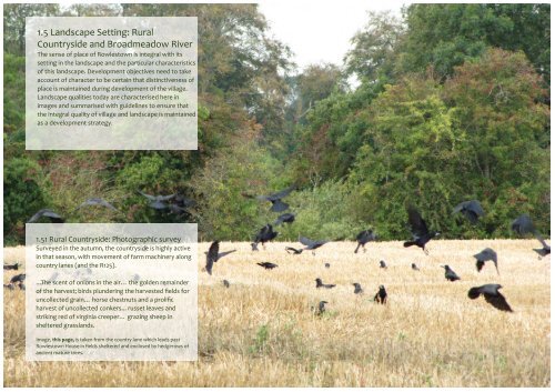
1.5 Landscape Setting: Rural<br />
Countryside and Broadmeadow River<br />
The sense of place of <strong>Rowlestown</strong> is integral with its<br />
setting in the landscape and the particular characteristics<br />
of this landscape. Development objectives need to take<br />
account of character to be certain that distinctiveness of<br />
place is maintained during development of the village.<br />
Landscape qualities today are characterised here in<br />
images and summarised with guidelines to ensure that<br />
the integral quality of village and landscape is maintained<br />
as a development strategy.<br />
1.51 Rural Countryside: Photographic survey<br />
Surveyed in the autumn, the countryside is highly active<br />
in that season, with movement of farm machinery along<br />
country lanes (and the R125).<br />
...The scent of onions in the air… the golden remainder<br />
of the harvest; birds plundering the harvested fields for<br />
uncollected grain… horse chestnuts and a prolific<br />
harvest of uncollected conkers... russet leaves and<br />
striking red of virginia creeper… grazing sheep in<br />
sheltered grasslands.<br />
Image, this page, is taken from the country lane which leads past<br />
<strong>Rowlestown</strong> House in fields sheltered and enclosed by hedgerows of<br />
ancient mature trees.<br />
<strong>Rowlestown</strong> Village Development Framework Plan iCON Architecture | Urban Design | Conservation, with Cummins and Voortman Section 1 <strong>17</strong>
<strong>Rowlestown</strong> Village Development Framework Plan iCON Architecture | Urban Design | Conservation, with Cummins and Voortman Section 1 18
Image, previous page: Grazing sheep in grasslands sheltered by ancient,<br />
mature trees. Taken from the country lane which leads past<br />
<strong>Rowlestown</strong> House.<br />
Image, this page: modern dormer house and industrial scale grain<br />
production share the countryside, the house benefitting from plentiful<br />
hedges and trees around the river to give privacy and a discreet<br />
appearance within the vegetation. This integration, a symbiosis of living<br />
and landscape can only be maintained at relatively low densities.<br />
<strong>Rowlestown</strong> Village Development Framework Plan iCON Architecture | Urban Design | Conservation, with Cummins and Voortman Section 1 19
Autumnal Images show, on this page, fallen conkers below horse chestnut<br />
tree, and leaves, nuts and shells from a beech tree. The background of<br />
woodland from which these images were taken is the area around the Lawn<br />
Gates entrance to <strong>Rowlestown</strong> House<br />
<strong>Rowlestown</strong> Village Development Framework Plan iCON Architecture | Urban Design | Conservation, with Cummins and Voortman Section 1 20
1.51 Rural Countryside (continued)<br />
Defining the Rural Countryside<br />
<strong>Rowlestown</strong>’s location in a special landscape is its<br />
distinctive quality.<br />
The shaping of its immediate landscape in a low-‐lying<br />
area accentuates the relatively small contour changes on<br />
either side of the river. The steepness of the river’s banks,<br />
and the likelihood of occasional flooding as it flows<br />
through the village has helped to limit the building up of<br />
the river’s edge. The <strong>County</strong> Development Plan (CDP)<br />
policies incorporate a 30m riparian zone on either side of<br />
the river to help biodiversity and to allow for a flooding<br />
margin. OPW and ‘FEMFRAM’ studies extend some areas<br />
further in recently measured areas liable to flooding.<br />
These margins can accommodate recreational use and<br />
the enjoyment of nature, provided public access can be<br />
achieved.<br />
The immediate areas beyond the village experience<br />
pressure for development; there is potential conflict<br />
between natural heritage policies and residential<br />
development strategies, as the river and riparian zones<br />
traverse the central areas of the village.<br />
Further out from the village, there is sporadic<br />
development close to the river, but the scenery, in the<br />
main survives. The combined CDP policies of green<br />
infrastructure and natural heritage provide strong cause<br />
to limit development in deference to the value of the<br />
landscape, especially the river and margins and the fine<br />
mature eighteenth and nineteenth century demesne<br />
landscape and hedgerows.<br />
<strong>Rowlestown</strong> Village Development Framework Plan iCON Architecture | Urban Design | Conservation, with Cummins and Voortman Section 1 21
1.52 Rural Countryside policies from the <strong>Fingal</strong><br />
Development Plan -‐ A Summary<br />
<strong>Fingal</strong>’s rivers support salmonid systems on several, including<br />
the Broadmeadow river. The 30m width of riparian corridor is<br />
needed to allow species such as otter, bat, kingfisher and<br />
dipper to thrive. “Because of their importance, all rivers will be<br />
maintained in an open, semi-‐natural condition, wherever<br />
possible.”<br />
The landscape is described as low-‐lying, a mix of arable and<br />
pasture farming. At <strong>Rowlestown</strong>, it varies from this general<br />
character because of the surrounding woodlands and river<br />
landscape. It is an objective “that all development proposals<br />
(should) include measures to protect and enhance<br />
biodiversity.” and to “ensure development reflects and, where<br />
possible, reinforces the distinctiveness and sense of place of<br />
the landscape character types...including various elements such<br />
as geology and landform, habitats, scenic quality, settlement<br />
pattern, historic heritage, local vernacular heritage, land-‐use<br />
and tranquility”<br />
“The major river corridors should be protected and improved<br />
by leaving a minimum 30 metre wide margin, on each side of<br />
these rivers, undeveloped and encouraging planting where<br />
appropriate, to enhance the landscape and habitat value of<br />
these corridors...Resist development such as houses… which<br />
would interfere with the character of highly sensitive areas or<br />
with a view or prospect of special amenity value, which it is<br />
necessary to preserve.”<br />
Among the Principles for Development, this advice is given on<br />
potential sites: “Sites with natural boundaries should be<br />
chosen, rather than open parts of larger fields. Clustering with<br />
existing farmhouse and/or farm buildings is generally preferable<br />
to stand-‐alone locations.”<br />
( Reference: <strong>Fingal</strong> <strong>County</strong> Development Plan 2011-‐20<strong>17</strong>)<br />
<strong>Rowlestown</strong> Village Development Framework Plan iCON Architecture | Urban Design | Conservation, with Cummins and Voortman Section 1 22
Above: Ducks foraging in the field at Lawn Gates, the entrance to <strong>Rowlestown</strong> House. No doubt the ducks, too, would appreciate easy access to the river.<br />
1.53 Broadmeadow River<br />
The river acts as a geographical feature which divides<br />
today’s village into north and south, with the two parallel<br />
roads, Church Road and R125, giving access to all the<br />
potential development areas. Thus, the river is actually a<br />
zone of natural vegetation which passes through the<br />
centre. The creation of a riverside walk with regular<br />
access to the development sites and the two roads,<br />
would make for a remarkable new network of walkable<br />
access in the village. At the same time it would be useful<br />
to plan walks to cross the river on pedestrian bridges.<br />
The images of the river which follow are those which may<br />
be obtained from public places, bridges and the R125.<br />
Right: Broadmeadow River downstream from the <strong>Rowlestown</strong> Bridge -‐ one<br />
of the few views available from public areas in the village. The river is set<br />
down in a deep cut to mitigate flooding.<br />
Far right: Potential access from the north side of the bridge and facing<br />
westwards, this path is barely accessible at present, and may not be a right<br />
of way.<br />
<strong>Rowlestown</strong> Village Development Framework Plan iCON Architecture | Urban Design | Conservation, with Cummins and Voortman Section 1 23
1.53 Broadmeadow River (continued)<br />
This area is visible from the eastern approach of the R125.<br />
It is a low lying flood plain on the Southern side and a<br />
quite steep escarpment on the northern side. Both sides<br />
so far have been kept free of development, and free<br />
from serious encroachment into the natural habitat. As<br />
part of a recreational corridor, this area might include a<br />
small lake.<br />
At the top of the escarpment, new houses overlook the<br />
river within a development on Church Road. The gable is<br />
a repetitive visual theme which does not dominate the<br />
scale of the riverside, although the positioning of the<br />
houses puts them on top of the horizon and quite<br />
conspicuous. Further planting at the upper level would<br />
help, in time, to diminish the visual impact.<br />
<strong>Rowlestown</strong> Village Development Framework Plan iCON Architecture | Urban Design | Conservation, with Cummins and Voortman Section 1 24
1.53 Broadmeadow River (continued)<br />
This is the easternmost point of the Local Area Plan<br />
Boundary. The bridge marks the boundary. Most of the<br />
lands visible in the images, left, occur within the flood<br />
plain and are precluded from development. The deep<br />
excavation, see below, of the riverbed to improve its<br />
capacity has left heaps of deposited gravel on the river<br />
bank. Time may further soften the crude intervention,<br />
and wildlife appears abundant in the area judging by the<br />
sight of two wading birds, seen in the photograph over<br />
the page; a grey heron, left and a little egret, right.<br />
<strong>Rowlestown</strong> Village Development Framework Plan iCON Architecture | Urban Design | Conservation, with Cummins and Voortman Section 1 25
<strong>Rowlestown</strong> Village Development Framework Plan iCON Architecture | Urban Design | Conservation, with Cummins and Voortman Section 1 26
1.53A. Development Guidelines for Landscape<br />
Setting: Rural Countryside and Broadmeadow<br />
River<br />
• The distinctive identity of <strong>Rowlestown</strong> is inseparable<br />
from its natural landscape and its historical<br />
development. This identity needs to be retained<br />
through development phases to maintain the character<br />
of place.<br />
• A strategy for protection should be put in place, not<br />
only for the Architectural Conservation Area, but for<br />
the Immediate and surrounding landscape of<br />
<strong>Rowlestown</strong>, including tree and hedgerow protection<br />
orders.<br />
• Management of the landscape should include further<br />
tree, shelter belt, screen and hedgerow planting to<br />
consolidate the existing landscape as development<br />
proceeds.<br />
• An inventory of biodiversity and the landscape<br />
elements should be undertaken.<br />
• Green corridors should be conserved.<br />
• The potential for extending green corridors should be<br />
retained in the development strategy as a long term<br />
measure, to ensure that future growth does not<br />
cut off the village from its landscape setting.<br />
• The quality and immediacy of the landscape within<br />
<strong>Rowlestown</strong> village suggests that future development<br />
should only be made at densities which take into<br />
account the fragility of balance between landscape and<br />
development.<br />
• The River, from the old school as far as the eastern<br />
bridge is already an ecological corridor of great beauty<br />
and recreational interest. An accessible route along<br />
the River would give a significant new amenity to the<br />
village.<br />
• Design approach should derive from a good<br />
understanding of the landscape within and around any<br />
development site. The design of the site should<br />
contribute positively towards the landscape heritage of<br />
the place.<br />
Type to enter text<br />
The corridor of nature running through <strong>Rowlestown</strong><br />
• The distinctive identity of <strong>Rowlestown</strong> is inseparable from its natural landscape and its historical<br />
development.<br />
• The River, from the old school as far as the eastern bridge is already an ecological corridor of great beauty<br />
and recreational interest. An accessible route along the River would give a significant new amenity to the<br />
village.<br />
<strong>Rowlestown</strong> Village Development Framework Plan iCON Architecture | Urban Design | Conservation, with Cummins and Voortman Section 1 27
Small fish swirl together below the Broadmeadow River bridge at the eastern end of the Local Area Plan boundary<br />
<strong>Rowlestown</strong> Village Development Framework Plan iCON Architecture | Urban Design | Conservation, with Cummins and Voortman Section 1 28
1.6 Entering the Village<br />
1.61 Entrance from Swords and M1<br />
This entrance is well announced because the village<br />
stretches out in a ribbon of development towards<br />
Swords. Arriving from that direction, the first landmark<br />
point, circled in white, is Kettles Country House Hotel<br />
with a small agglomeration of detached bungalows at<br />
the start of Balcultry Road and Rath Road, followed by<br />
a zig-‐zag across the countryside, and a long run into the<br />
village proper underneath a canopy of trees. The<br />
landscape experience is eventful and interesting, but<br />
not enjoyable as the road is a busy regional road with<br />
heavy goods vehicles in prominence. It is<br />
uncomfortable for drivers, unpleasant for a pedestrian<br />
using the footpath along the road, and dangerous for a<br />
cyclist, as drivers maintain a high speed into and<br />
through the village. With little likelihood of bypassing<br />
the village there is a strong case for limiting the size of<br />
trucks and imposing effective traffic calming measures<br />
to give some comfort to cyclists and pedestrians.<br />
<strong>Rowlestown</strong> Village Development Framework Plan iCON Architecture | Urban Design | Conservation, with Cummins and Voortman Section 1 29
1.63 Local Road Entrance from North<br />
This entrance is a local lane originally serving fields and<br />
agriculture, and still apparently lightly used. It is a<br />
delightful sequence, a walk through a little changed<br />
landscape, passing by the farm entrance to <strong>Rowlestown</strong><br />
House ➀ and along its boundary, sloping down to the<br />
sharp left turn into Church Road ➁.<br />
The lane, like others in the <strong>County</strong>, makes for ideal<br />
country walking, with glimpses across fields and a strong<br />
connection with nature and the farming landscape.<br />
Signalling the quality of the road by defining it as a ‘green<br />
lane’ for cyclists and pedestrians first would improve<br />
safety along the lane and may help to conserve its<br />
qualities for the future.<br />
1.63A. Development Guidance for Entrance<br />
from North<br />
• Consider defining the lane, along with others as a<br />
‘green lane’ with speed restriction and cycle and<br />
pedestrian priority<br />
• Traffic calming is effected already with narrow<br />
width, no footpaths and winding lane.<br />
• Continue to manage the lane with hedgerow<br />
trimming and verge cutting.<br />
➊ ➋<br />
<strong>Rowlestown</strong> Village Development Framework Plan iCON Architecture | Urban Design | Conservation, with Cummins and Voortman Section 1 32
1.64 Local Road Entrance from<br />
East<br />
This entrance is also a local lane. It is the<br />
continuation of Church Road, and<br />
connects back to the R125. It appears to<br />
be busy during school arrival and<br />
departure times, but otherwise is<br />
relatively quiet. It may be identified as<br />
one of the lanes around <strong>Rowlestown</strong><br />
which would be suited to a walking and<br />
cycling network allowing for loop walks.<br />
The stretch of lane eastwards after the<br />
church is relatively straight; cars travel at<br />
speed along this stretch and any<br />
proposal would need to take into<br />
account the need to reduce speed and<br />
increase safety for pedestrians and<br />
cyclists.<br />
➀ View looking back to church and<br />
community centre on Church Road. Car<br />
turning is heading for the entrance to<br />
the school on <strong>Rowlestown</strong> Drive.<br />
➁ Lane looking eastwards is straight<br />
with a series of entrances to individual<br />
houses and housing clusters.<br />
1.64A. Development Guidance for Entrance<br />
from East<br />
• Consider defining the lane, as a ‘green lane’ with<br />
speed restriction, and cycle and pedestrian<br />
priority<br />
• As there are numerous entrances with further<br />
development proposed, traffic calming is<br />
necessary; the lane is straight, and susceptible to<br />
speeding.<br />
• Continue to manage the lane with hedgerow<br />
trimming and verge cutting.<br />
➊ ➋<br />
<strong>Rowlestown</strong> Village Development Framework Plan iCON Architecture | Urban Design | Conservation, with Cummins and Voortman Section 1 33
<strong>Rowlestown</strong> House, service entrance with farm<br />
outbuildings, virginia creeper and guard dog<br />
<strong>Rowlestown</strong> Village Development Framework Plan iCON Architecture | Urban Design | Conservation, with Cummins and Voortman Section 1 34
OSI permit, <strong>Fingal</strong> <strong>County</strong><br />
<strong>Council</strong><br />
1.7 Architectural Heritage<br />
1.71 <strong>Rowlestown</strong> House<br />
The OS 1839 <strong>42</strong> map, left, gives a good impression of<br />
the house within its demesne. Built in <strong>17</strong>80, there is a<br />
paddock or park, giving formal access through the<br />
Lawn Gates and supervised with a Gate Lodge. The<br />
gardens around the house are structured and appear<br />
to have walled gardens and orchard in sheltered<br />
areas. The access to the farmyard and rear is from the<br />
agricultural lane on its western side.<br />
The front of the house is a five bay symmetrical<br />
composition with unusually large windows. The<br />
window above the arched door has six panes for each<br />
of two sliding sashes, whereas the rest are four panes<br />
for each of two sliding sashes on the first floor, and<br />
two panes for each of two sliding sashes on the<br />
ground floor, suggesting at least two window<br />
replacements since its construction. Despite this and<br />
the unusually large proportion of window to wall, the<br />
facade is a handsome one and a piece of heritage in<br />
<strong>Rowlestown</strong> to cherish.<br />
<strong>Rowlestown</strong> Village Development Framework Plan iCON Architecture | Urban Design | Conservation, with Cummins and Voortman Section 1 35
➋<br />
➌<br />
➍<br />
1.51 <strong>Rowlestown</strong>e House (continued): ➊ : ‘Lawn Gates’ , the original formal entrance to <strong>Rowlestown</strong> House, which had a gate lodge on the left, now gone. ➋: The garden seen through the side<br />
gate on the local lane at the side of the property ➌ : The rear courtyard of the house, through the gate at the side. ➍: Entrance gate from the side with corrugated iron roofed farm buildings covered in virginia creeper<br />
<strong>Rowlestown</strong> Village Development Framework Plan iCON Architecture | Urban Design | Conservation, with Cummins and Voortman Section 1 36<br />
➊
1.72 The Police Station, vernacular thatched<br />
cottages and Gate Lodge<br />
The image, right, from the nineteenth century shows the<br />
original Police Station, now extended, three thatched<br />
cottages, no longer there, and the slated gate lodge also<br />
demolished. The photograph was provided by the Begg<br />
family, who live in the refurbished and extended old<br />
Police Station.<br />
The old Police Station has been extended by two bays.<br />
The photograph provides a unique insight into the<br />
appearance of the village. Picture inset, left show the<br />
building today with its form and side arch through to the<br />
rear intact. Cottages have been replaced with a painted<br />
blockwork wall. The thatched cottage, barely visible on<br />
the picture beyond the station, is still there, although<br />
with corrugated iron roof. A precious image...<br />
<strong>Rowlestown</strong> Village Development Framework Plan iCON Architecture | Urban Design | Conservation, with Cummins and Voortman Section 1 37
1.73 Vernacular thatched cottage beyond<br />
the Police Station, and Gate Lodge<br />
The image, from the previous page, is used to<br />
make a comparison between the buildings on<br />
site today and the same buildings just about<br />
visible in the photograph.<br />
Both buildings are thatched in the original and<br />
have a corrugated iron replacement today. The<br />
earlier image confirms that the thatch was half-‐<br />
hipped at the gable .<br />
The image, below, combines the current photo<br />
with the old one, confirming the match between<br />
the old gable and the replacement covering.<br />
<strong>Rowlestown</strong> Village Development Framework Plan iCON Architecture | Urban Design | Conservation, with Cummins and Voortman Section 1 38
Top, left: Bridge parapet and the gable of<br />
the Old Mill, held in mature riverside<br />
landscape.<br />
Top, centre: View of one of the<br />
corrugated iron roofs of the cluster of<br />
buildings of the Old Mill, taken from a<br />
higher vantage point.<br />
Bottom, left: Steep pitch of one of the<br />
hipped gables, and reducing thickness<br />
made in a gentle curve.<br />
Bottom, right: Image taken from<br />
YouTube video, showing some of the<br />
hirsting or hurst, the internal structure<br />
which contains the machinery of a water<br />
mill without conveying vibrations to the<br />
building structure<br />
1.74 Old Mill at Killossery, beside bridge<br />
The Old Mill is a remarkable survival from, it is said,<br />
the eighteenth century. Its position in the village is<br />
pivotal, at the junction between Old Killossery and<br />
Old <strong>Rowlestown</strong>, and beside the bridge across the<br />
Broadmeadow River. It is in deteriorated condition,<br />
but is capable of careful restoration to keep its<br />
essential qualities of structure, the mechanical parts<br />
inside still remaining, and even some of its fittings,<br />
such as the shop counter. These we would consider<br />
to be among the most important vernacular<br />
buildings in Co <strong>Fingal</strong>, especially as they act as a<br />
cluster. We would strongly recommend an action<br />
plan to save and restore these buildings for future<br />
generations.They make a natural gathering location<br />
for the village and could generate regional<br />
attraction as a centre for entertainment in the<br />
atmosphere of a really old group of buildings.<br />
<strong>Rowlestown</strong> Village Development Framework Plan iCON Architecture | Urban Design | Conservation, with Cummins and Voortman Section 1 39
1.75 The Church and Old Graveyard<br />
The church is a landmark building for the Village,<br />
with its tall bell-‐tower as the highest object in the<br />
area. The church was built around 1854 in gothic<br />
style with steep roof pitch. Close to the school<br />
and beside the community centre, this is the active<br />
centre of <strong>Rowlestown</strong>. The community centre is<br />
bulky, with a form which obstructs the fine,<br />
graceful angles of the church, yet it is a strong<br />
symbol of the community, and is in regular use<br />
during the week.<br />
The graveyard is probably the oldest occupied<br />
land in the area with the remains of an ancient<br />
church on the site.<br />
Above: Some of the most ancient headstones in the graveyard at Killossery, and right, the entrance gate and steps through the graveyard wall<br />
<strong>Rowlestown</strong> Village Development Framework Plan iCON Architecture | Urban Design | Conservation, with Cummins and Voortman Section 1 40
1.76 Old and New National Schools<br />
The Old National School was vacated some years<br />
ago, when a remarkable new school replaced it on a<br />
large site set back from but connected to Church<br />
Road along the newly constructed <strong>Rowlestown</strong> Drive.<br />
The old school, below, is a handsome building<br />
from the middle of the 20th century. Modernised and<br />
revitalised, it could be reused to fulfill some<br />
promising new function, yet to be discovered. It<br />
would be a pity to see such a usable agglomeration of<br />
built space being wasted. By contrast the new school<br />
is a generous and attractive modern answer to the<br />
idea of a school, accommodating a large number of<br />
children on a campus.However its detached location<br />
favours arrival and pick up by car, even for people<br />
living in the village. Better pedestrian and cycle links<br />
in the village and surroundings are possible, to<br />
overcome this drawback.<br />
<strong>Rowlestown</strong> Village Development Framework Plan iCON Architecture | Urban Design | Conservation, with Cummins and Voortman Section 1 41
<strong>Rowlestown</strong> Village Development Framework Plan iCON Architecture | Urban Design | Conservation, with Cummins and Voortman Section 1 <strong>42</strong>


