

Howth St. Nessans & St. Peters Terrace ACA Statement of Character
Howth St. Nessans & St. Peters Terrace ACA Statement of Character
Howth St. Nessans & St. Peters Terrace ACA Statement of Character

You also want an ePaper? Increase the reach of your titles
YUMPU automatically turns print PDFs into web optimized ePapers that Google loves.
<strong>St</strong>. <strong>St</strong>. Nessan’s Nessan’s <strong>Terrace</strong>, <strong>Terrace</strong>, <strong>St</strong>. <strong>St</strong>. Peter’s Peter’s <strong>Terrace</strong>,<br />
<strong>Terrace</strong>,<br />
Seaview Seaview <strong>Terrace</strong> <strong>Terrace</strong> <strong>Terrace</strong> & & The The Haggard, Haggard, <strong>Howth</strong><br />
<strong>Howth</strong><br />
Architectural Architectural Conservation Conservation Area<br />
Area<br />
<strong>St</strong>atement <strong>St</strong>atement <strong>of</strong> <strong>of</strong> <strong>Character</strong> <strong>Character</strong><br />
<strong>Character</strong><br />
1
• Introduction<br />
Contents<br />
Contents<br />
• Location & Boundary <strong>of</strong> Architectural Conservation Area<br />
• Historical Development <strong>of</strong> the area<br />
• Schedule <strong>of</strong> Protected <strong>St</strong>ructures & Recorded Monuments<br />
• Development Plan Zoning & Objectives<br />
• Description <strong>of</strong> Existing Built Environment<br />
• Summary <strong>of</strong> Special <strong>Character</strong><br />
• Implications for Planning and Development<br />
2
NOTE:<br />
NOTE:<br />
This document includes Ordnance Survey Ireland data reproduced under OSi Licence number<br />
2003/07/CCMA/Fingal County Council. Unauthorised reproduction infringes Ordnance Survey<br />
Ireland and Government <strong>of</strong> Ireland copyright.<br />
©Ordnance Survey Ireland, 2006.<br />
Permission has been granted by the Map Library, Trinity College Library, Dublin for the<br />
reproduction <strong>of</strong> Figures 2, 3 and 4 which are extracts from early Ordnance Survey Maps.<br />
A copy <strong>of</strong> the early 20 th century postcard <strong>of</strong> <strong>Howth</strong> (Figure 5) was obtained from the collection held<br />
by the Fingal County Archives <strong>of</strong> Fingal County Council.<br />
3
Introduction<br />
Introduction<br />
Many <strong>of</strong> the towns and villages <strong>of</strong> Fingal contain areas <strong>of</strong> architectural, historical, and/or cultural<br />
interest, which have a particular distinctive character considered worthy <strong>of</strong> retention and<br />
enhancement. Planning legislation allows a planning authority to include objectives in the County<br />
Development Plan to preserve the character <strong>of</strong> a place, area, group <strong>of</strong> structures or townscapes,<br />
taking account <strong>of</strong> building lines and heights, that:<br />
is <strong>of</strong> special architectural, historical, archaeological, artistic, cultural, scientific, social or<br />
technical interest or value or<br />
contributes to the appreciation <strong>of</strong> protected structures.<br />
The title given to these areas or places is Architectural Conservation Areas, or <strong>ACA</strong>s for short.<br />
Currently, there are 28 <strong>ACA</strong>s designated in Fingal.<br />
An <strong>ACA</strong> could encompass, for example, a terrace <strong>of</strong> houses, a whole streetscape, town centre, or a<br />
small cluster <strong>of</strong> structures associated with a specific building such as a mill or country house.<br />
Most structures in an <strong>ACA</strong> are important in how they positively contribute to the streetscape or<br />
character <strong>of</strong> an area. Therefore, in <strong>ACA</strong>s the protection relates to the external appearance <strong>of</strong> such<br />
areas or structures. Any Any works works that that would would would have have a a mate material mate material<br />
rial rial effect effect effect effect (i.e. (i.e. (i.e. impact) impact) impact) on on the the character character <strong>of</strong><br />
<strong>of</strong><br />
an an an <strong>ACA</strong> <strong>ACA</strong> require require planning planning permission,<br />
permission, permission, even works that are outlined in the Planning Regulations as<br />
not normally needing planning permission, and known as Exempted Development. This does not<br />
prevent alterations, extensions or new build within <strong>ACA</strong>’s but the designation seeks to ensure that<br />
any new development respects or enhances the special character <strong>of</strong> the area and is carried out in<br />
consultation with the Planning Department and Conservation Officer, usually through a planning<br />
application.<br />
This document is one in a series that set out to identify the special character <strong>of</strong> each individual <strong>ACA</strong><br />
and give guidance to homeowners, developers and planning pr<strong>of</strong>essionals on the type <strong>of</strong> works that<br />
would require planning permission in that specific area.<br />
4
Location Location and and Boundary Boundary Boundary <strong>of</strong> <strong>of</strong> the the Conservation Conservation Area<br />
Area<br />
<strong>Howth</strong> village is located on a peninsula extending out from the north-eastern shore <strong>of</strong> Dublin Bay.<br />
The peninsula is dominated by the Hill <strong>of</strong> <strong>Howth</strong>, which rises to 560 ft at its highest point, and is one<br />
<strong>of</strong> the most prominent features <strong>of</strong> North County Dublin. <strong>Howth</strong> is about nine miles from Dublin City<br />
Centre, and is considered today to be a coastal suburb <strong>of</strong> Dublin City. Within Fingal it forms part <strong>of</strong><br />
the southern boundary with Dublin City Council’s area.<br />
The main settlement <strong>of</strong> <strong>Howth</strong> village is located on the northern side <strong>of</strong> <strong>Howth</strong> Hill, with views to the<br />
north extending out over its 19 th century harbour <strong>of</strong> Ireland’s Eye, the northern coastline <strong>of</strong> County<br />
Dublin, and the Irish Sea.<br />
The boundary <strong>of</strong> the <strong>ACA</strong> extends from <strong>St</strong>. Nessan’s <strong>Terrace</strong> to all <strong>of</strong> Seaview <strong>Terrace</strong> and No. 2 to<br />
10 The Haggard (No. 1 is within the boundary <strong>of</strong> the <strong>Howth</strong> Historic Core <strong>ACA</strong>). It also includes Nos. 1<br />
to 7 Balglass Road and the former school building on Balglass Road, as well as most <strong>of</strong> <strong>St</strong>. Peter’s<br />
<strong>Terrace</strong> (apart from the 2-storey houses in the horse-shoe cul-de-sac at the southern end). These<br />
streets slope uphill and are located on a very elevated site, overlooking the village core, with views<br />
<strong>of</strong> the harbour, Ireland’s Eye, Lambay, and the coastline <strong>of</strong> North County Dublin, apart from The<br />
Haggard, which is located slightly below the other streets, and appears to have been constructed<br />
first. This area <strong>of</strong> single-storey terraced cottages is accessed <strong>of</strong>f Main <strong>St</strong>reet or <strong>St</strong>. Lawrence Road.<br />
The numbering <strong>of</strong> these structures appears to confirm the impression that most <strong>of</strong> these houses<br />
were constructed as a group, as the numbering starts at No. 1 at the junction <strong>of</strong> Seaview <strong>Terrace</strong><br />
and Main <strong>St</strong>reet, continues along <strong>St</strong>. Nessan’s <strong>Terrace</strong> to its junction with Tuckett’s Lane, and<br />
carrys on into <strong>St</strong>. Peter’s <strong>Terrace</strong> up to No. 91. Only The Haggard, as well as the group <strong>of</strong> cottages<br />
on Balglass Road and the more modern infill on Tuckett’s Lane and <strong>St</strong>. Nessan’s Court and Close<br />
break with this numbering system.<br />
5
6<br />
Fig. Fig. 1 Boundary <strong>of</strong> <strong>St</strong>. Nessan’s <strong>Terrace</strong>, <strong>St</strong>. Peter’s Peter’s <strong>Terrace</strong>, <strong>Terrace</strong>, Seaview <strong>Terrace</strong> & The Haggard <strong>ACA</strong>
Historical Historical Development Development <strong>of</strong> <strong>of</strong> the the Area<br />
Area<br />
The earliest record <strong>of</strong> <strong>Howth</strong> is from the 2 nd century on a map compiled by Ptolmey.<br />
Traces <strong>of</strong> the earliest settlers remain in the form <strong>of</strong> portal tombs and Iron Age<br />
promontory forts. During the 9 th century <strong>Howth</strong> was one <strong>of</strong> the chief Viking<br />
settlements in Dublin. However, it was during the 19 th century that <strong>Howth</strong> took the<br />
form that is recognisable today as a popular seaside destination, with the<br />
construction <strong>of</strong> the harbour and many <strong>of</strong> the large houses within the village itself and<br />
the surrounding environs.<br />
Fig. Fig. 2 2 Extract Extract <strong>of</strong> <strong>of</strong> Main Main <strong>St</strong>reet <strong>St</strong>reet <strong>St</strong>reet and<br />
and<br />
The The The Haggard Haggard from from Ordnance<br />
Ordnance<br />
Survey Survey Map Map 1870<br />
1870<br />
appear to have been constructed sometime between<br />
1902 and 1906. The Post Office Directory <strong>of</strong> Dublin for the<br />
year 1910 notes that some additional houses have been<br />
constructed and that rent for these properties ranges<br />
from £2 10s to £3 each. Cartographic and written<br />
sources indicated that <strong>St</strong>. Peter’s <strong>Terrace</strong> was built<br />
sometime between 1910 and 1929. Thom’s Directory <strong>of</strong><br />
1929 refers to the street and the amount <strong>of</strong> rent paid<br />
while the layout is first shown on the 1936 Ordnance<br />
Survey Map.<br />
The lands inbetween Seaview <strong>Terrace</strong> and <strong>St</strong>. Peter’s<br />
<strong>Terrace</strong> were infilled in the late 20 th century with <strong>St</strong>.<br />
Nessan’s Court and Close.<br />
The Haggard was built first, as the 2 nd edition <strong>of</strong> the<br />
Ordnance Survey Maps (1870) show an east-west<br />
terrace <strong>of</strong> opposing houses. Seaview <strong>Terrace</strong>, <strong>St</strong>.<br />
Nessan’s <strong>Terrace</strong>, and the houses on the Balglass<br />
Road seem to have been constructed as one entitiy in<br />
the very early years <strong>of</strong> the 20 th century. These streets<br />
appear on the 1907 edition <strong>of</strong> the Ordnance Survey,<br />
while Thom’s Directory <strong>of</strong> Dublin for the year 1906 lists<br />
23 inhabitants for <strong>St</strong>. Nessan’s Cottages and 20<br />
inhabitants for Seaview <strong>Terrace</strong>. There are no mention<br />
<strong>of</strong> the terraces in the 1902 edition <strong>of</strong> Thom’s so they<br />
Fig. Fig. 3 3 <strong>St</strong>. <strong>St</strong>. Nessan’s Nessan’s <strong>Terrace</strong><br />
and and and Seaview Seaview <strong>Terrace</strong> <strong>Terrace</strong> from<br />
from<br />
Ordnance Ordnance Survey Survey Map Map 1907<br />
1907<br />
7
Fig. Fig. 4 4 Extract Extract <strong>of</strong> <strong>of</strong> area area from from 1936 1936 edition edition <strong>of</strong> <strong>of</strong> Ordnance Ordnance Survey Survey Map<br />
Map<br />
The former national school building on Balglass Road appears from cartographic<br />
evidence to be late 19 th century or early 20 th century in date, as it is shown on the 25<br />
inch maps from the Ordnance Survey <strong>of</strong> Ireland, which were surveyed between 1897<br />
and 1913. It no longer functions as a national school but appears now to be only used<br />
occasionally for different community purposes.<br />
Fig. Fig. 5 5 5 Early Early Early 20 20 20<br />
th century century postcard postcard <strong>of</strong> <strong>of</strong> <strong>Howth</strong> <strong>Howth</strong> with with <strong>St</strong>. <strong>St</strong>. Nessan’s Nessan’s <strong>Terrace</strong> <strong>Terrace</strong> visible visible on on the the ridgeline<br />
ridgeline<br />
8
Schedule Schedule <strong>of</strong> <strong>of</strong> Protected Protected <strong>St</strong>ructures <strong>St</strong>ructures & & Recorded Recorded Monuments<br />
Monuments<br />
There are no Protected <strong>St</strong>ructures within the boundaries <strong>of</strong> this Architectural<br />
Conservation Area.<br />
There are also no known archaeological sites, features, artefacts, etc., listed as<br />
Recorded Monuments on the Record <strong>of</strong> Monuments and Places, within the boundaries<br />
<strong>of</strong> the <strong>ACA</strong>.<br />
Development Development Plan Plan Zoning Zoning & & Objectives<br />
Objectives<br />
In the Fingal Development Plan 2005 –2011 the land is zoned Objective RS - To provide<br />
for residential development and to protect and improve residential amenity.<br />
9
Description Description <strong>of</strong> <strong>of</strong> Existing Existing Built Built Environment<br />
Environment<br />
• <strong>St</strong>reet <strong>St</strong>reet pattern pattern & & materials<br />
materials<br />
The streets within the boundary <strong>of</strong> the <strong>ACA</strong> vary in orientation. <strong>St</strong>. <strong>Peters</strong> <strong>Terrace</strong> is a<br />
long linear north to south road sloping uphill, with opposing groups <strong>of</strong> terraces along<br />
the eastern and western sides <strong>of</strong> the road. The houses on this street are grouped into<br />
four terraces <strong>of</strong> six houses on each side <strong>of</strong> the road, with each house stepping uphill<br />
slightly from its neighbour. Seaview <strong>Terrace</strong> is L-shaped, with houses located on only<br />
one side <strong>of</strong> the street. The long section <strong>of</strong> this terrace is orientated eastwards, while<br />
the short section has houses facing northwards and slopes downhill towards Main<br />
<strong>St</strong>reet. The houses on Seaview <strong>Terrace</strong> tend to step up the changing gradient in pairs<br />
<strong>of</strong> two. The Haggard has two opposing north-south terraces <strong>of</strong> five houses, and is on<br />
a lower level than the other streets within the <strong>ACA</strong>. <strong>St</strong>. Nessan’s <strong>Terrace</strong> consists <strong>of</strong><br />
two back-to-back rows <strong>of</strong> opposing terraces running east to west, which are split in<br />
half by an uphill north-south road. There are three houses in each terrace group,<br />
apart from the most southerly row, which consists <strong>of</strong> four houses.<br />
The road and footpath materials are modern, using concrete<br />
and tarmacadam. There is a jostle stone located on the<br />
corner <strong>of</strong> No. 29 <strong>St</strong>. Nessan’s <strong>Terrace</strong>. Jostle stones where<br />
used to protect buildings from damage by carriages or carts<br />
passing close by at a narrow point in the road or as they<br />
turned corners. There are other examples <strong>of</strong> these in <strong>Howth</strong><br />
on Church <strong>St</strong>reet and Main <strong>St</strong>reet.<br />
• Form Form & & arrangement arrangement arrangement <strong>of</strong> <strong>of</strong> <strong>of</strong> public public open open space<br />
space<br />
The Haggard, Nos. 1 to 7 & Balglass Road, <strong>St</strong>. Nessan’s <strong>Terrace</strong>, Seaview <strong>Terrace</strong> and<br />
<strong>St</strong>. Peter’s <strong>Terrace</strong> are all private residential streets with no public open space areas.<br />
The properties on Seaview <strong>Terrace</strong> and <strong>St</strong>. Nessan’s <strong>Terrace</strong> front directly onto the<br />
street, while the other terraces within the <strong>ACA</strong> have small private front gardens<br />
separating them from the road.<br />
• Socio Socio-Economic Socio Socio Economic Functions<br />
Functions<br />
The houses are in private ownership, in residential use. The majority are occupied<br />
and in good condition. However, the area around the Former National School,<br />
Balglass Road is poorly maintained.<br />
Fig. Fig. Fig. 6 6 Jostle Jostle stone stone on<br />
on<br />
<strong>St</strong>. <strong>St</strong>. Nessan’s Nessan’s Nessan’s Tce Tce<br />
Tce<br />
10
• Built Built Fabric<br />
Fabric<br />
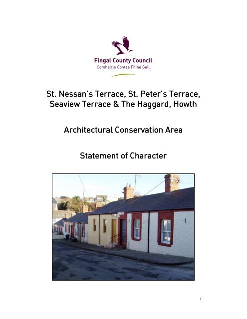
Although the houses within this <strong>ACA</strong> are modest terraced cottages, the overall<br />
uniformity <strong>of</strong> design gives the area its distinctive character. The houses are three-bay<br />
single –storey structures with pitched slate ro<strong>of</strong>s and red-brick chimneys. On most <strong>of</strong><br />
the streets the houses have a central entrance door with a window on either side.<br />
However, on Seaview <strong>Terrace</strong>, the three-bay configuration has the entrance door to<br />
one <strong>of</strong> the side bays, with a window in the centre bay and the other side bay. The<br />
houses were probably originally rendered with a roughcast render and with door and<br />
window surrounds detailed in brick. It would appear that the original windows were<br />
two-over-two up-and-down timber sash windows, and that the original doors were<br />
simple timber doors with a glazed section in or over the door.<br />
Figs. Figs. 7 7 & & 8 8 Seaview Seaview <strong>Terrace</strong> <strong>Terrace</strong> (streetscape (streetscape and and individual individual house)<br />
house)<br />
Figs. Figs. 9 9 & & 10 10 <strong>St</strong>. <strong>St</strong>. Nessan’s Nessan’s <strong>Terrace</strong> <strong>Terrace</strong> <strong>Terrace</strong> (streetscape (streetscape (streetscape and and individual individual house)<br />
house)<br />
Figs. Figs. Figs. 11 11 & & 12 12 <strong>St</strong>. <strong>St</strong>. Peter’s Peter’s <strong>Terrace</strong> <strong>Terrace</strong> (streetscape (streetscape and and individual individual house)<br />
house)<br />
11
Fig. Fig. 13 13 The The Haggard Haggard<br />
Fig. Fig. 14 14 Balglass Balglass Road<br />
Road<br />
However, over the decades a number <strong>of</strong> changes have occurred to individual<br />
properties, which include: the removal <strong>of</strong> the render, to either leave the rubble<br />
stonework exposed or to re-plaster/re-clad the exterior walls; the addition <strong>of</strong> small<br />
front porches; the replacement <strong>of</strong> the original windows and doors; the installation <strong>of</strong><br />
ro<strong>of</strong> lights; and the construction <strong>of</strong> rear extensions, some <strong>of</strong> which are visible from<br />
the road due to the variations in contour levels in the area,<br />
Seaview <strong>Terrace</strong> and <strong>St</strong>. Nessan’s <strong>Terrace</strong> front directly onto the street, with some<br />
houses having a small set <strong>of</strong> steps up to the front door due to the changing levels in<br />
gradient. <strong>St</strong>. Peter’s <strong>Terrace</strong>, The Haggard and Balglass Road all have small front<br />
gardens with boundary walls and pedestrian gate separating them from the roadway.<br />
These boundary walls are <strong>of</strong> a simple design, generally with a central pedestrian gate,<br />
although a number on <strong>St</strong>. Peter’s <strong>Terrace</strong> have been altered to accommodate <strong>of</strong>f-<br />
street carparking. Also, the boundary walls along <strong>St</strong>. Peter’s <strong>Terrace</strong>s are stepped as<br />
the road changes gradient uphill.<br />
Most <strong>of</strong> the streets are only able to facilitate on-street parking due to the houses<br />
fronting directly onto the street and no road or laneway access to the rear <strong>of</strong> the<br />
properties. However, <strong>St</strong>. Peter’s <strong>Terrace</strong> does have adequate space in its front<br />
gardens, and access to the rear to allow <strong>of</strong>f-street parking, and a number <strong>of</strong><br />
properties have installed driveways.<br />
The houses are generally in a good state <strong>of</strong> repair,<br />
although there are one or two properties in the area in<br />
poor condition. The former school on Balglass Road<br />
appears not to be in use and the area around it is<br />
unkempt.<br />
Fig. Fig. 15 15 Former Former Former National<br />
National<br />
School School , , Balglass Balglass Road<br />
Road<br />
12
• Views iews<br />
Due to the single-storey house heights, changing levels in gradient, and the elevated<br />
nature <strong>of</strong> the area, nearly all <strong>of</strong> the streets have views out over <strong>Howth</strong> Harbour <strong>of</strong><br />
Irelands Eye and the eastern coastline <strong>of</strong> north County Dublin. Tucketts Lane also<br />
has views <strong>of</strong> the landmark structure <strong>of</strong> the Church <strong>of</strong> the Assumption on Main <strong>St</strong>reet.<br />
These views contribute to the character <strong>of</strong> the area and it is important that new<br />
development in the area does not negatively impact on or obscure these views.<br />
Fig. Fig. 116<br />
1 6 View <strong>of</strong> sea sea from <strong>St</strong>. Peter’s Peter’s <strong>Terrace</strong> Fig. Fig. 17 17 View View from from Seaview Seaview <strong>Terrace</strong> <strong>Terrace</strong><br />
<strong>Terrace</strong><br />
Fig. Fig. 18 18 View View from from <strong>St</strong>. <strong>St</strong>. <strong>St</strong>. Nessan’s Nessan’s Nessan’s <strong>Terrace</strong> <strong>Terrace</strong><br />
Fig. Fig. 19 19 View View <strong>of</strong> <strong>of</strong> sea sea from from from Balglass Balglass Road<br />
Road<br />
13
Summary Summary <strong>of</strong> <strong>of</strong> Special Special <strong>Character</strong><br />
<strong>Character</strong><br />
The special character <strong>of</strong> this <strong>ACA</strong> is primarily associated with the early 20th century<br />
terraced cottages along <strong>St</strong>. Peter’s <strong>Terrace</strong>, <strong>St</strong>. Nessan’s <strong>Terrace</strong>, Seaview <strong>Terrace</strong>,<br />
The Haggard, and part <strong>of</strong> Balglass Road. Although some alterations have occurred to<br />
the external appearance <strong>of</strong> the terraces and their boundary treatments, overall the<br />
low-rise, small-scale terraced nature <strong>of</strong> this area has remained fundamentally<br />
unaltered since the construction <strong>of</strong> these streets.<br />
The modest nature <strong>of</strong> these early 20 th century terraces, along with the overall<br />
uniformity <strong>of</strong> the simple design <strong>of</strong> the houses, has resulted in a distinctive<br />
homogenous vernacular character that sets this area apart from the rest <strong>of</strong> <strong>Howth</strong><br />
village.<br />
Fig. Fig. Fig. 15 15 Aerial Aerial view view <strong>of</strong> <strong>of</strong> <strong>ACA</strong> <strong>ACA</strong> area<br />
area<br />
14
15<br />
Fig. Fig. 16 16 16 Annotated Annotated Map<br />
Map
Implications Implications for for Planning Planning and and Development<br />
Development<br />
The objective <strong>of</strong> Architectural Conservation Area designation is to protect the special<br />
character <strong>of</strong> an area through the careful control and positive management <strong>of</strong> change<br />
<strong>of</strong> the built environment. Therefore, the assigning <strong>of</strong> <strong>ACA</strong> status on a streetscape,<br />
cluster <strong>of</strong> buildings, or a town/village core results in restrictions restrictions on on certain certain certain works works to<br />
to<br />
the the exteriors exteriors <strong>of</strong> <strong>of</strong> structures structures within the boundary <strong>of</strong> the <strong>ACA</strong>. Owners, occupiers, or<br />
developers proposing to carry out works within an <strong>ACA</strong> should be aware that in<br />
general, planning permission will be required for any new build to the front <strong>of</strong> the<br />
structure and changes <strong>of</strong> original materials, such as windows, wall finishes, boundary<br />
walls, ro<strong>of</strong> coverings etc. While new development and alterations to existing<br />
structures can still occur subject to planning, proposal should respect or enhance the<br />
area’s special character.<br />
More detailed direction is given overleaf on the type <strong>of</strong> works that do and do not<br />
impact on the character <strong>of</strong> this <strong>ACA</strong> and therefore will or will not require planning<br />
permission. As <strong>St</strong>. Nessan’s Court, <strong>St</strong>. Nessan’s Close, and the late 20 th century<br />
houses on Tuckett’s Lane between <strong>St</strong>. Nessan’s <strong>Terrace</strong> and <strong>St</strong>. Peter’s <strong>Terrace</strong> are<br />
modern infill, they are not subject to the above objectives, except where the works<br />
might block views. However, they must still adhere to the general provisions <strong>of</strong> the<br />
Planning and Development Acts 2000-2002 relating to works that do require planning<br />
permission<br />
16
WORKS NOT AFFECTING THE CHARACTER OF THE <strong>ACA</strong> (DO NOT REQUIRE<br />
PLANNING PERMISSION)<br />
• MAINTENANC<br />
MAINTENANCE MAINTENANC E & & REPAIRS<br />
REPAIRS<br />
Planning permission is not required for regular maintenance works and genuine<br />
repairs within this <strong>ACA</strong> (such as ro<strong>of</strong>, rainwater goods or window repairs) as long as<br />
original materials are retained where they exist, or where replacement is necessary<br />
that it is on a like-for-like basis.<br />
• INTERNAL INTERNAL ALTERATIONS<br />
ALTERATIONS<br />
<strong>ACA</strong> designation for this area does not prevent internal changes or re-arrangements,<br />
as none <strong>of</strong> the houses are Protected <strong>St</strong>ructures, and as long as these changes do not<br />
impact on the exterior <strong>of</strong> the structure.<br />
• RESTORATION RESTORATION OF OF OF CHARACTER<br />
CHARACTER<br />
Where original materials have been removed and replaced with modern or<br />
inappropriate alternatives, the restoration or reinstatement <strong>of</strong> these features will not<br />
require planning permission where the method, materials and details for the works<br />
have been agreed with the Conservation Officer.<br />
• WORKS WORKS TO TO THE THE PUBLIC PUBLIC REALM<br />
REALM<br />
In general, works to the public domain will be carried out by Fingal County Council or<br />
the major utility and service providers, and may be exempt from planning permission.<br />
However, consultation with the Conservation <strong>St</strong>aff <strong>of</strong> Fingal County Council will be<br />
required before any works commence to ensure that these works enhance and<br />
improve the character <strong>of</strong> the area and do not negatively impact on it, such as: traffic<br />
management & parking schemes; undergrounding <strong>of</strong> wiring and services; public<br />
lighting schemes; urban improvement schemes.<br />
17
WORKS IMPACTING ON THE CHARACTER OF THE AREA (WORKS REQUIRING<br />
PLANNING PERMISSION)<br />
• EXTERNAL EXTERNAL EXTERNAL WALLS WALLS<br />
WALLS<br />
The The The removal removal <strong>of</strong> <strong>of</strong> <strong>of</strong> external external re render re nder to to expose expose rubble rubble stone stone work or brickwork brickwork, brickwork<br />
as the<br />
render or plaster provides a water-resisting surface that protects the building from<br />
decay. The majority <strong>of</strong> structures in <strong>Howth</strong> are rendered. Often the rubble stonework<br />
or brickwork underneath this render is <strong>of</strong> poor quality, as it was never meant to be<br />
exposed to the elements. Therefore, the removal <strong>of</strong> this external finish is deemed<br />
unacceptable.<br />
The The cladding cladding <strong>of</strong> <strong>of</strong> external external walls walls with with different different finishes, finishes, such such as as stone stone or or timber<br />
timber<br />
cladding. cladding. The special character <strong>of</strong> residential streets within this <strong>ACA</strong> is associated<br />
with the uniformity <strong>of</strong> the design <strong>of</strong> the terraces. The original external appearance <strong>of</strong><br />
these terraces was a rendered finish. Thus, any proposals to alter this finish by the<br />
addition <strong>of</strong> external cladding is considered to negatively impact on the character <strong>of</strong><br />
the area.<br />
• ROOF<br />
ROOF<br />
The The removal removal <strong>of</strong> <strong>of</strong> the the original original slate slate ro<strong>of</strong>ing ro<strong>of</strong>ing material material or or chimneys, chimneys,<br />
and their<br />
replacement with modern materials, or the taking down <strong>of</strong> chimney stacks<br />
permanently. Original elements should be retained where possible as they can<br />
generally be repaired and reused and they contribute to the character <strong>of</strong> the area.<br />
The The installation installation <strong>of</strong> <strong>of</strong> ro<strong>of</strong> ro<strong>of</strong> lights lights or or dormer dormer windows windows on on the the front front elevations elevations <strong>of</strong> <strong>of</strong> the<br />
the<br />
terraces terraces. terraces Ro<strong>of</strong> lights should be placed on inner or hidden pitches <strong>of</strong> a ro<strong>of</strong> and any<br />
planning applications for dormer windows should be to rear elevations.<br />
Changes Changes to to the the ro<strong>of</strong> ro<strong>of</strong> pitch pitch angle, angle, ridge ridge height, height, span span <strong>of</strong> <strong>of</strong> ro<strong>of</strong>. ro<strong>of</strong><br />
Many <strong>of</strong> the streetscapes<br />
with the <strong>ACA</strong> boundary consist <strong>of</strong> terraces <strong>of</strong> houses with similar ro<strong>of</strong> pitches, heights,<br />
etc and so the alteration <strong>of</strong> the pr<strong>of</strong>ile <strong>of</strong> just one structure could have an impact on a<br />
number <strong>of</strong> adjoining structures<br />
Installation Installation <strong>of</strong> <strong>of</strong> satellite satellite antenna, antenna, TV TV aerials aerials and and other other communications communications devices<br />
devices devices. The<br />
addition <strong>of</strong> these to the front elevations or ro<strong>of</strong>s <strong>of</strong> the terrace is considered to have a<br />
negative impact on the character <strong>of</strong> the area and should be avoided. Satellite dishes<br />
should not be visible on the front elevation <strong>of</strong> buildings. Where possible, less visible<br />
methods for getting TV reception, such as cable, should be used and where the<br />
existing aerials have become redundant they should be removed.<br />
18
• WINDOW WINDOW & & DOOR DOOR OPENINGS<br />
OPENINGS<br />
The The alteration alteration <strong>of</strong> <strong>of</strong> window window openings openings and and external external doors, doors<br />
namely the enlargement <strong>of</strong><br />
openings or the removal <strong>of</strong> original windows, doors, sills and doorsteps, and/or the<br />
replacement <strong>of</strong> original features with materials such as PVC or aluminium. Original<br />
elements should be retained where possible as they can generally be repaired and<br />
reused and they contribute to the character <strong>of</strong> the area. Unfortunately, only a few<br />
structures within the <strong>ACA</strong> still have their original windows or doors. Where windows<br />
have already been altered prior to the <strong>ACA</strong> designation, owners will be encouraged to<br />
consider a more appropriate window material and glazing pattern (two-over-two up-<br />
and-down timber sash windows) if they intend to change their windows in the future.<br />
• PORCHES<br />
PORCHES<br />
The The addition addition <strong>of</strong> <strong>of</strong> porches porches to to the the front front façade façade <strong>of</strong> <strong>of</strong> buildings buildings requires requires planning<br />
planning<br />
permission. permission. A number <strong>of</strong> houses within the <strong>ACA</strong> have had small porches added to the<br />
front elevation. However, there has been a variety in the style and materials used.<br />
Only certain streets within the <strong>ACA</strong>, such as <strong>St</strong>. Peter’s <strong>Terrace</strong> and The Haggard,<br />
have the ability to facilitate porches as they do not directly front onto the street.<br />
While, the precedent has already been established on these streets regarding small<br />
front porches, planning permission will be required for the addition <strong>of</strong> any porches in<br />
the future and should adhere to a similar style, namely small central-bay porches<br />
with pitched slate ro<strong>of</strong>, so as to try to re-establish the uniformity <strong>of</strong> building design<br />
along the streetscape.<br />
• EXTENSIONS<br />
EXTENSIONS<br />
Extensions in general should be to the rear <strong>of</strong> the property and should not extend<br />
above the existing ridge line. Their design should be subsidiary to the main building,<br />
<strong>of</strong> an appropriate scale, and use appropriate materials. Due to the elevated nature <strong>of</strong><br />
the area some rear elevations are very visible from the road, such as those on <strong>St</strong>.<br />
Nessan’s <strong>Terrace</strong> and Balglass Road. Many <strong>of</strong> these houses have already extended<br />
their properties and the variety and scale <strong>of</strong> these extensions do impact on the area.<br />
Any future proposals for rear extensions or alterations to existing rear extensions on<br />
these highly visible sites would require planning permission and should consult prior<br />
to the submission <strong>of</strong> the planning application with the Area Planner and Conservation<br />
Officer as there is the potential to negatively impart on the <strong>ACA</strong>.<br />
19
• NEW NEW BUILD BUILD AND AND INFILL INFILL<br />
INFILL<br />
Designation as an <strong>ACA</strong> puts an onus on prospective developers to produce a very high<br />
standard <strong>of</strong> design, which respects or enhances the particular qualities <strong>of</strong> the area.<br />
New build does not need to directly imitate earlier styles, but should be designed with<br />
respect to its context, therefore sympathetic modern designs that are complimentary<br />
to the character <strong>of</strong> the <strong>ACA</strong> may be acceptable. New build on these elevated sites<br />
should respect the existing building lines and follow the pattern set historically <strong>of</strong><br />
single-storey structures.<br />
A certain amount <strong>of</strong> infill development has already occurred prior to <strong>ACA</strong> designation,<br />
such as <strong>St</strong>. Nessan’s Court and Close. The rear gardens <strong>of</strong> <strong>St</strong>. Peter’s <strong>Terrace</strong> could<br />
facilitate backland development but the scale, mass, and height should match the<br />
single-storey nature <strong>of</strong> <strong>St</strong>. Peter’s. The Former National School on Balglass Road is<br />
one <strong>of</strong> the larger sites within the <strong>ACA</strong>. This structure is a positive contribution to the<br />
<strong>ACA</strong> and part <strong>of</strong> the social history <strong>of</strong> <strong>Howth</strong> and should be retained if any proposals<br />
are submitted to develop the site.<br />
• AMALGAMATION AMALGAMATION OF OF PROPERTIES<br />
PROPERTIES<br />
PROPERTIES<br />
The The amalgamation amalgamation <strong>of</strong> <strong>of</strong> structures structures requires planning permission irrespective <strong>of</strong><br />
whether located in an <strong>ACA</strong> or not, unless it involves reversing the subdivision <strong>of</strong> what<br />
had originally been a single dwelling. Any proposals to merge two or more properties<br />
together internally should retain the proportions <strong>of</strong> the openings <strong>of</strong> the original front<br />
elevations <strong>of</strong> the structures.<br />
• DEMOLITION<br />
DEMOLITION<br />
Demolition Demolition <strong>of</strong> <strong>of</strong> any any building building building within within the the <strong>ACA</strong>. <strong>ACA</strong>. <strong>ACA</strong>. With regard to the terraces <strong>of</strong> houses, the<br />
demolition <strong>of</strong> any one house in this group would have a very significant detrimental<br />
affect on the area, and therefore it is highly unlikely that permission for demolition<br />
will be granted. Where permission is sought for demolition on the grounds <strong>of</strong><br />
structural defects or failure, a report containing photographs and drawing(s)<br />
indicating locations <strong>of</strong> photographs will be required, produced by a suitably qualified<br />
and experienced pr<strong>of</strong>essional regarding the existing condition. As part <strong>of</strong> the<br />
justification for any demolition within the <strong>ACA</strong> on structural grounds, details will be<br />
required <strong>of</strong> repairs/remedial works normally used in similar circumstances and<br />
details <strong>of</strong> why they are not suitable in that instance.<br />
20
• BOUNDARY BOUNDARY TREATMENTS TREATMENTS &&<br />
& & CARPARKING<br />
CARPARKING<br />
There is a level <strong>of</strong> uniformity to the boundary treatments and therefore any proposals<br />
to change them should consult with the Area Planner and Conservation Officer.<br />
Planning permission will be required for the creation <strong>of</strong> a new driveway and the<br />
dishing <strong>of</strong> the footpath, this applies irrespective <strong>of</strong> the <strong>ACA</strong> designation.<br />
• VIEWS<br />
VIEWS<br />
Preservation Preservation <strong>of</strong> <strong>of</strong> views views. views The key seaviews <strong>of</strong> <strong>Howth</strong> Harbour, Ireland’s Eye, and the<br />
eastern coastline <strong>of</strong> North County Dublin from the streets with the <strong>ACA</strong> should be<br />
preserved and development within the area and on the lower slopes <strong>of</strong> <strong>Howth</strong> should<br />
not adversely impact on the <strong>ACA</strong> or block these views.<br />
NOTE:<br />
Some <strong>of</strong> the works listed above require planning permission irrespective <strong>of</strong> whether<br />
the area is protected or not, but are included to highlight the need for careful<br />
consideration <strong>of</strong> the design <strong>of</strong> the proposed works to ensure that they do not impact<br />
negatively on the character <strong>of</strong> the area. The above list is not in itself a comprehensive<br />
list <strong>of</strong> all works, in all circumstances, that require planning permission, but identifies<br />
those works that would impact on the character <strong>of</strong> the <strong>ACA</strong>. Development works<br />
would still have to adhere to the general provisions <strong>of</strong> the Planning and Development<br />
Acts 2000-2002 and Planning Regulations. The Area Planner and Conservation Officer<br />
<strong>of</strong> Fingal County Council can be consulted if there is any doubt as to whether planning<br />
permission is required or not.<br />
21


