Kleinham's Discovery Part 2 - Flathead County, Montana
Kleinham's Discovery Part 2 - Flathead County, Montana
Kleinham's Discovery Part 2 - Flathead County, Montana

You also want an ePaper? Increase the reach of your titles
YUMPU automatically turns print PDFs into web optimized ePapers that Google loves.
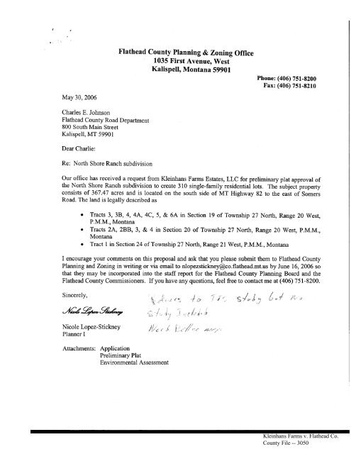
May 30,2006<br />
Charles E. Johnson<br />
<strong>Flathead</strong> <strong>County</strong> Road Department<br />
800 South Main Street<br />
Kalispell, MT 59901<br />
Dear Charlie:<br />
Re: North Shore Ranch subdivision<br />
<strong>Flathead</strong> <strong>County</strong> Planning & Zoning Office<br />
1035 First Avenue, West<br />
Kalispell, <strong>Montana</strong> 59901<br />
Phone: (406) 751-3200<br />
Fax: (406) 751-8210<br />
Our office has received a request from Kleinhans Farms Estates, LLC for preliminary plat approval of<br />
the North Shore Ranch subdivision to create 310 single-family residential lots. The subject property<br />
consists of 367.47 acres and is located on the south side of MT Highway 82 to the east of Somers<br />
Road. The land is legally described as<br />
o Tracts 3, 38, 4, 4A, 4C, 5, & 6A in Section 19 of Township 27 North, Range 20 West,<br />
P.M.M., <strong>Montana</strong><br />
o Tracts 21^, 2BB, 3, & 4 in Section 20 of Township 27 North, Range 20 West, P.M.M.,<br />
<strong>Montana</strong><br />
o Tract I in Section 24 of Township 27 North, Range 21 West, P.M.M., <strong>Montana</strong><br />
I encourage your comments on this proposal and ask that you please submit them to <strong>Flathead</strong> <strong>County</strong><br />
Planning andZoning in writing or via email to nlopezstickney@co.flathead.mt.us by June 16, 2006 so<br />
that they may be incorporated into the staff report for the <strong>Flathead</strong> <strong>County</strong> Planning Board and the<br />
<strong>Flathead</strong> <strong>County</strong> Commissioners. If you have any questions, feel free to contact me at (406) 751-8200.<br />
Sincerely,<br />
rkg*ge4v<br />
Nicole Lopez-Stickney<br />
Planner I<br />
Attachments: Application<br />
Preliminarv Plat<br />
Environmental Assessment<br />
s /*,-,{ j ,C ,, gl ."{' "<br />
Kleinhans Farms v. <strong>Flathead</strong> Co.<br />
<strong>County</strong> File -- 3050
This application shall be submitted, along with all information required by the applicable Snffi;ion<br />
Regulations and the <strong>Montana</strong> Subdivision and Platting Act, and tl'.e appropriate fee to:<br />
Ftrathead Couaty plannfng & Zonfng Offiee 1(}85 FiFt Avea.ue W*<br />
Montara 59901 - Phone: 7S1-82fi) Faxr ?$1-821()<br />
APPLICATION T'OR IilA"IOR SUBDNTISION PRELIMI!{ARY PLAT APPRO\IAL<br />
FEEATTACHED $r4gg&-<br />
F'EE SCHEDUI.E:<br />
' Mdor $ubdivision (6 or mare lots)<br />
- Base Fee..,.,....... ,..,.......... SZSO<br />
- First 2O lots....... ...$80/1ot<br />
- ,\dditional lots above 2O.............. ......,- $+O/lot<br />
. Condominiums f6 orrnoreunits),...,.,,, ...,.$75b +<br />
. Mobile Home Parks & Campgrounds f6 or more epores)... $Z5O +<br />
. Arnended Preliminary P1at.....,.,.... S3OO +<br />
. Subdivision Variance.... ,,....., $ZOO<br />
. Commercial/Indusffial Subdivisiprr............,. $iOOO<br />
r Subsequent Minor SuMivision ....,........... S750<br />
. $5O Pre-Appti&ionfee is due dtletime af meetfug (tnajor & nrrunercial<br />
* Add i .ll d, sl.{-<br />
--- ^^ t^-^ ^^r:a^-t 7:at 1^ ^^-.^- ^J:^:-i*- 1--l^*---<br />
$4 per address (see wrtifed list/ to cover adjoinirrg landowner -^;r. mailing<br />
SUBDWISION NASIE: Nqrth thpre Ranch ,. _ ,<br />
oWlSER{s} oF RtCoRD:<br />
Name: Klginhqns,Farrns Estates-. I,LC Phone: (650)365-{q2O .<br />
Mailing Address: l399,Wiscpnsin Avenrle ,<br />
City, $tate, Zip Code: WhitSfish.-,MT,59937 , , .,<br />
TECHI{ICAL/PROFESSIO$AL PARTICIPAIYTS (surreyor/Deeignef/Englneel, eto}:<br />
Name & Address Sqnds SurvwinE. Inc, 2 Vil<br />
Nnme & Address 9a:.ver Ensneennq. 1995 3d Ave<br />
Name & Address.Epikos Desiprr. P"O. Eo+ 2<br />
Name & Address RLE Hv4,ro, Ine, P,Q. Box I<br />
LECAL DESCRIPflON OF PROPERTY:<br />
CiE/ <strong>County</strong> <strong>Flathead</strong> Cowrtv<br />
Street Address . MT $ta!g tliehwa,v 8?. Somers ..<br />
'!t'o4ft f g ,^^<br />
.*#h*-
GENTRAL DESCRXPTIoIT/TYPE oF SUBDIVISION: 310 Lqt. $inqle*fe:nily suhdiyigion<br />
with equestrian facilities and open space.<br />
Number of Lots or Rental Spaees 31q . Total Acreage in Subdivision 362.420<br />
Total Acreage in Lots , tr72.q% - . - Minimum size of Lots or spaces q.z14 ..<br />
Total Acreage in Streets or Roads 37,4W. Maximum Size of Lots or $paces 1.953<br />
Total Acreage in Parks, Open $paces and/or Common Areas<br />
PROPO8ED U$P{SI AilD ISUMBBR OF ASSOCTATDD IOTS/$FACE$:<br />
single F''amily *ruglg* Townhouse<br />
Mobile Home park<br />
Duplex Aparknent Recreational Vehicle Park<br />
commercial- Industriel . planned. urrit Development<br />
-<br />
Condominium_ Multi-Family<br />
AFPLICABTD zOlTIIuc DESIGISA"IOI{ & DrsTRrCts<br />
ESTIMATE OF ilIARKET VALUE BETORT IilIPROVE}IEtrTS: $J[4.60Q/ACrE<br />
IMPRO\MMEI$TS TO BE FROVIDED:<br />
Roadel Gravel *J*Paved-curb<br />
[Iater $Sretem:<br />
Alleys<br />
User<br />
-Gutter -sidewalks<br />
-Individual<br />
-other<br />
-Multiple -Neighborhood<br />
other utilittes: cable TV 4 ..Telephone X_Electric *x__-Gas other<br />
--X-pqblie _other<br />
Sewer System: _Individual _Multiple User _Neighborhood _X**public _Other<br />
solid wasts:<br />
Pick Up<br />
storage *[-contract Hauler<br />
Matl Delivery;<br />
-Hone __{_Central , ,Individqal -Central ----* School District: $oqrprF Lakeside #29<br />
-owner<br />
Ftre Frotectlon:<br />
9mlnage Slysteml<br />
-Hydrants<br />
Haul<br />
-&-Tanter Recharge -* Fire District some{s vo,tgnteer {D<br />
PRoPOSED ERoSIOI{/SEDIIIEI{TA?IO!5 cOsTRoL: . As nqed wit}r constructio{} fo4o,win$<br />
thq BMPs<br />
vaRLlLlTcPs; aRE A,ily vltRlar{cEs REquEsrED? No {yes/no)<br />
(If Ves, ptease rcmptete ttw i4formstion Aeioi)<br />
SECTIOil/REGULATIOT{ OF ITEGULATIONS CRPATTSG HARDSHIF;<br />
EXPLAIN TIIE HaRDSHIP THAT srouLD BE cREATED wrrll srRrcr colilptrArircE ou.<br />
REGUTATTOITS:<br />
Kleinhans Farms v. <strong>Flathead</strong> Co.<br />
<strong>County</strong> File -- 3052
-t.)<br />
PROPOSED AI,TERNATTVE(SI TO STRICT COMFLIAIYCES UNTIT ABoItE<br />
RDGULATIOIT$,<br />
P&SASE AI{SWER THE FOLLOWMG QUSSTTOTSS ffi THE SFACES PROVIDED BELOTtr:<br />
1. Will the granting of tl.e variance be detrinrentat to the public health, safeqii or general<br />
welfare or injurious to other adjoining properties?<br />
2. Will the varianee cause a substantial increase in public costs?<br />
3. Will the variance affect, in any manner, the provisions of any adopted zoning<br />
regulations or Master Plan?<br />
4. Are there special circumstances related to the physieal characteristics of tl-e site<br />
{topography, Bha.pe, ete.) that create the hardship?<br />
5. What other conditions are unique to thi3 properby that ereate the need for a varianee?<br />
Kleinhans Farms v. <strong>Flathead</strong> Co.<br />
<strong>County</strong> File -- 3053
.sFPrrrcATra $,co NTEI{TS :<br />
1.<br />
2.<br />
3.<br />
4.<br />
5.<br />
6.<br />
Completed Preliminary Plat application (If submitting a bound copy of the application<br />
material.s, please - -<br />
also include one unhound copy for replication purposes).<br />
16 folded copies of the preliminary plat.<br />
One reproducible-set of supplemental information (See Appendix A -<strong>Flathead</strong> <strong>County</strong><br />
Subdivision Regulations) .<br />
TWo reduced copies of the preliminary ptat:<br />
a. one lL" x 17" in size<br />
b. one I rh' x 11" in size<br />
Application fee.<br />
A Oegilipd Adjoining Property Owners List.<br />
A' certlfr€d' adJohrng tantdowttera ttst rrr..scbe fne&lrdr;d.ttlmn srtJlttd.sstan of gour agtp1,c616,on- Tteform<br />
dtdQhed to tle back af this apptiedi'on mux be filted "r"t, ag"A ig a pranner, a ti6. tot un to the Grs departman<br />
{34 Jtoor of courttnuse) ta be initided' Ttw'ost is $is,iogoblu to the GIS affice. vour certified. Iist witt be<br />
awdlabte for pickup one w*k Jtnm the fute odsd, ;rd "*, be picked.up'{ntru-na Raom. you mag atso get<br />
a Certified aQiainin'g landouners ttst frrlm atitte'ur,,{rurr*:g if gowiiou..<br />
*tl*********************************'*********"*rt********rk****************rrrt****cr********************x*r!rr*r<<br />
******************'
APPLICATION CONTENTS:<br />
1.<br />
2.<br />
3.<br />
AT.<br />
5.<br />
6.<br />
Completed Preliminary Plat application (If submitting a bound copy of the application<br />
materials, please also include one unbound copy for replication purposes).<br />
16 folded copies of the preliminary plat.<br />
One reproducible set of supplemental information (See Appendix A -<strong>Flathead</strong> <strong>County</strong><br />
Subdivision Regulations) .<br />
T\ro reduced copies of the preliminary plat:<br />
a. one 1L" x 17" in size<br />
b. one 8 Yz" x L1" in size<br />
Application fee.<br />
A Certilled Adjoining Property Owners List.<br />
****rk***t(*t(***rt*******r!t(rrt<br />
ATTENTIONT<br />
A Certlfled q1dJatntng lolndowners tist rr.raust be tnchtded za.pon strbtrrtsston of gour appltcatlon. Ttrc form<br />
attached ta the back of thi"s application must be filled otrt, sigrwd bg a plarmer, & then taken to tlle GIS departm'ent<br />
(3d floor of Courthause) tn be initioted.. Ttrc cost is $75, pagable tp ttrc GIS office. Your Certified li'st will be auailabLe<br />
for pick up or'le week from the date ordered. and can be picked up in tte PIot Room. You mag also get a Certified<br />
adjoining Landowners li.st from a tille compang if gou choose.<br />
Incomplde wltlnot be<br />
rkt
NORTH SHORE RANCH<br />
ENVIRONMNNTAL ASSESSMENT<br />
GENERAL INSTRUCTIONS<br />
This Environmental Assessment format shall be used by the applicant as a guide in<br />
compiling a thorough description of the potential impacts for the proposed subdivision,<br />
Each question pertinent to the proposal must be addressed in full (both maps and text);<br />
those questions not applicable shall be so stated. Inconnplete Environmental Assessrnents<br />
will not be accepted. The sources ofinformation for each section of the Assessment shall<br />
be identified. AII Environmental Assessments shall contain the signature, date of<br />
signature and mailing address of the owRer of the property and the persoq or persons,<br />
preparing the report.<br />
I. GEOLOGY<br />
A. Locate on a copy ofthe preliminary plat;<br />
1. Any known hazards affecting the development which could result in property damage<br />
or personal injury due to:<br />
a. Falls, slides or slumps - goil, rock, mud, snow.<br />
b. Aoy rock outcropping.<br />
B' Describe. any proposed measures to prevent or reduce the danger of property damage<br />
or personal injury from any ofthese hazards.<br />
North Shore Ranch<br />
Kleinhans Farms v. <strong>Flathead</strong> Co.<br />
<strong>County</strong> File -- 3056
II. SIIRFACE WATER (Locate on a copy of the preliminary plafi)<br />
A. Any natural water systems such as streams, rivers, intermittent strearns, lakes or<br />
marshes (also indicate the names and sizes of each).<br />
Therg are no s,treqms.lpcated.on the p(operty. .There arg. wetla4d identified on thg<br />
southeast corner of the project ?n{is hatched on the preliminary plat.<br />
B. Any artificial water systems such as canals, ditches, aqueducts, reservoirs and<br />
irrigation systems (also indicate the names, sizes and present uses of each).<br />
The. rp. arelo water systems such,as canals, ditches. aquedusts of rqservojfs. There is an<br />
irrigation pipe that supplies irrigation water to the prqperty. Thg $ourge.of the waterjB<br />
FlAthead l-,ake, The ruplioants wish to keep the irrjgatlon fighls for providing water to<br />
the open space.<br />
C. Any areas subject to flood bazard, or if available, 100-year floodplain maps (using<br />
be st available information).<br />
Ihp property is mapped in Flood Zonq C (Areas of rninimal floodi+g), B (Areap betweer<br />
100 and 500 year flood) and Zone A (.A.feas of 100-year flood). The property is lgqated<br />
oq FIRM PaneJs 22808 and 2285D, (See attpchpd FIRM Panels). Only the Zonp A areas<br />
alq in the Special Flood Hagafd A,fea and slrbject to the restrictions of the FlaJhead<br />
Cpunty Floodway and Floodplain Rggulations,<br />
IIt VAGETATTON<br />
A Locate on a copy of the preliminary plat the major vegetation types within the<br />
subdivision (e,g., marsh, grassland, shrub and forest).<br />
devoid of trpes. Ttre doJninant vegetatioq is agric,ultural crops afrd a mix of native apd<br />
Pho-to).<br />
B. Describe the amount of vegetation that is to be removed, or cleaned, from the site, and<br />
state the rea$ons for such removal.<br />
open qpace which will be managed for grazing'<br />
C. Describe any proposed measure$ to be taken to protect vegetative cover'<br />
North Shore Ranch<br />
Kleinhans Farms v. <strong>Flathead</strong> Co.<br />
<strong>County</strong> File -- 3057
W. WILDLIFE (The Wildlife Section prepared by RLK Hydroo Inc)<br />
The Mqntana Eish.. Wildlife and Parks (.MFW&P.) Geographic Information System (GIS)<br />
system and the U.$, ,Fish apd Wildlife Service Natipnal Wetlands Inyqntory were<br />
pearched,to compile data to desoribe thp potef4ial impqcts for thp proposed subdivision.<br />
Thp is$ueq addressed.. es required by the ,Flatbea,d Cop$ty Subdivisipn Regulations.<br />
February 2000. are as follolqs:<br />
A. What major species of fish and wildlife, if any, use the arca to be affected by the<br />
proposed subdivision?<br />
The MFW&P GIS data indioate that the major ,ppecies.of fish. and wildlife thaj use-the<br />
area and ma)' hg affected bli thg propospd subdiviqion include waterfowl. whitetail dee.r.<br />
other areas in the Flathqad Valley. , Tlre,present .agricu.ltural land is considered eood to<br />
eXcellgnt hahitaj for pheasants. is occupied by wild tr+rkej's, and , is cQnsiderqd a<br />
transitio&l area for=mo,ose trawliqg between summpr and winter r;gis. per a phone<br />
convetsalion with GaQl Bissell" MFW&P Wil4life Biologisl on Aplil :. _200d- the<br />
8.. Locate on a copy ofthe preliminary plat any known important wildlife areas, such as<br />
big game winter range, waterfowl nesting areas, habitat for rare and endangered species<br />
and wetlands.<br />
North Shore Ranch<br />
Kleinhans Farms v. <strong>Flathead</strong> Co.<br />
<strong>County</strong> File -- 3058
C. Describe tlny proposed mea$rlres to protect wildlife habitat or to minimize habitat<br />
degradation.<br />
include paIks. ponds,, and trail,s. This will provide habitat for species to_rest and fCIrpgp<br />
u\ as well as tra,v.el thro,ugh. AquAtiq vegetalisn l,vill be established in,..pnd around the<br />
ponds to provide a source of food and. cpver for wgterfowl, asJn'ell as othgr species. The<br />
opeq areagj-hroqghout thq ploperty and,along the trailq will be plante4 with a.selection gf<br />
t{eEs. shrubs, forbs. and grasses that will satisfy the needs of,yildlife for food and cover.<br />
Fieure I *Wetlands Man<br />
V, AGRTCULTURN AND TIMBNR PRODUCTION<br />
A. State the acreage, h/pe and agricultural classifications of soils on the site.<br />
This past year the site was planted in barlelr. whed. [t?y*and grasS lan4, rhe so$s rypes<br />
are Some.rs Silty, Cla-y rp.am with a Cl.a$s trw-l capabilitl/.,Somers Silty Clay wilh a<br />
Class IIe-1. and Blanchard Loamy Fine Sqrrd,with.a Class fVes-l capabili8,<br />
B. State the history of produotion of this site by crop type and yield.<br />
otBarley depepding on m?nagemgnt practicqs.<br />
North Shore Ranch<br />
Kleinhans Farms v. <strong>Flathead</strong> Co.<br />
<strong>County</strong> File -- 3059
C. State the historical and ounent agricultural uses which occur adjacent to the site.<br />
Adjacent agnpultural uses hgtude wheat bqrley and hay fields north qf Highwa.y-82.and<br />
to tbg.east ofthe proposed devglopment.<br />
D. Explain any steps which will be taken to avoid or limit development conflists with<br />
adjacent agricultural uses.<br />
E. If the site is tilbered, state any timber management reoommendations which may<br />
have been suggested or implemented by the U.S.D.A. Division of Forestry in the area of<br />
this proposal.<br />
Thq propqrtv is got forested and is.fl.ot 4djacpnt to pnJ.U$FS latrdr. Thrr. *n ,, ttt^<br />
W IIISTORICAL' ARCHAEOL0GICA.L OR CULTURAL FEATURES<br />
A. Locate on u :opy _ of the preliminary ptat qny known or possible historic,<br />
archaeologieal or cultured sites which eNist on oi nua, thl site.<br />
I' Ptp:tue aly known-or possible sites delineated on the preliminary plat. page 82 -<br />
<strong>Flathead</strong> <strong>County</strong> Subdivision Regulations<br />
Ther.e are no knovrJr qiteg<br />
C' Describe tlny msosures that will be taken to protect such sites or properties.<br />
See previous.<br />
VIL SEWAGE TREATMENT (This section was prepared by carver<br />
Engineering)<br />
A. where individual sewage treatment systems are proposed for each parcel;<br />
North Shore Ranch<br />
Kleinhans Farms v. <strong>Flathead</strong> Co.<br />
<strong>County</strong> File -- 3060
1. Indicate the distanoe to the nearest public or community sewage treatment system.<br />
2. Provide as atfachments:<br />
a. Two (2) copies of the plat which shows the proposed suitable location on each<br />
lot for a subsurfac€ treatment system and a 1Q0% replacement area for the<br />
subsurface treatment system. Show the location of neighboring wells and<br />
zubsurfaoe treatmont $y$tems and the distances to each.<br />
MA<br />
b. The results of percolation tests performed in representative areas for drainfields<br />
in accordance with the most reoent Department of Environmental Quatity<br />
Bulletin. Each percolation test shall be keyed by a number on e copy of the plat<br />
with the information and results provided in the report. The number of<br />
preliminary percolation tests required shall be one-fourth (1/4) ofthe total number<br />
of proposed lots and these tests shall be performed in the different soil types, or<br />
evenly spaced throughout the subdivision in the absence of soil variability.<br />
N/A<br />
c. A detailed soils description for the area shall be obtained from test holes at least<br />
seven (7) feet in depth. The number of test holes will depend upon the variability<br />
of the soils. The U.S. Department of Agrieulture's "Soils Classification System"<br />
shall be used in the descriptions. Information on the internal and surface drainage<br />
oharacteristics shall be included. Each test hole shall be keyed by a number on a<br />
copy of the plat with the information provided for in the report.<br />
N/A<br />
d. A description of the following physical conditions:<br />
(1) Depth to groundwater at time of year when water table is nearest the<br />
surface and how this information was obtained.<br />
N/A<br />
(2) Minimum depth to bedrock or other impervious material, and how this<br />
information was obtained.<br />
N/A<br />
North Shore Rench<br />
Kleinhans Farms v. <strong>Flathead</strong> Co.<br />
<strong>County</strong> File -- 3061
B. For a proposed public or community sewage treatment system:<br />
A new pgblic sewage collpction will serve the loJs. being proposed with treatment<br />
pfovided at the Lakeside.Wastewalpr lreatment Eaoility.<br />
1. Estimate the average number of gallons of sewage generated per day by the<br />
subdivision when fully developed.<br />
B4sed on a total of 310 single-family lo$s or d)rgelling units, and an ,average dail]'<br />
wapjewpter flow of 22Q gallqfrs "per day ,(gpd) per :dwelhng unit. the total average<br />
daily waptewater flow will be 58,200,gpd, , using a peaking factor of 3.82, the peak<br />
hourly flow will be 1_80.9 gpm.<br />
2. Where an existing system is to be used:<br />
Spwer servrge to North Shore Rar-rqh will be prov-ided bI' a.new ppblic collection<br />
pystqm with trealment provJded flt the-e+isti+g L+kesidp Wastewatqr Treatmqnt<br />
Fqcility.<br />
a. Identi8r the system and the person, firm or agency responsible for its operation<br />
and maintenanoe.<br />
b, Indicate the system's capacity to handle additionai use and its distance from the<br />
development.<br />
c. Provide evidence that permission to connect has been granted.<br />
3. Where a new system is proposed:<br />
North ShoreRanch<br />
Kleinhans Farms v. <strong>Flathead</strong> Co.<br />
<strong>County</strong> File -- 3062
a. Attach a copy of the plat showing the location of all collection lines and the<br />
location and identification of the basio oornponents of the treatment svstem.<br />
' 8]'PVC sewer mains and 4'o co$grete {nanholes to servq Lots I * ZI,,Lots<br />
115 * 140, and Lpts 301.- 3 10.<br />
. A $et*otk pf 2", 3"- 4'.' &.6" IQPP fo{ce -ains that .qerue the r"mqlnine<br />
lots whqe each lot will, have.an.individual Envirqnment one grinder<br />
pumpirtg,syEtem.<br />
. Two (2) duplex serVage lift statioqs.<br />
..Ap 8l' IID. PE force main tbpt, c.prlvelrs all wasteWater from North Shore<br />
Raqgh to the Lakesi4e WaslewflLer Lr_eatqe$t Fapilitl'.<br />
b. If subsurface treatment of the effluent is proposed, grve the results of the<br />
preliminary analysis and percolation tests in the area of the treatment site.<br />
Subpr+r.face treatr-nent .of wpstgwater is not being pfoposed. Treatg$ effluent frorn<br />
thg Lakeqide lYastew4ter Trea{ment Fppility isSgfrently applied en the,grpund<br />
sr+rft ce b.v--gpr4y irri gation.<br />
c. Provide a description of tle following physical conditions:<br />
(1) Depth to groundwater at time of year when water table is nearest the<br />
surface and how this information was obtained.<br />
SEaso{ral high groundwater is at or near the gfound sqrfacgin-the lgwest arepq<br />
of the prgperfy (mprshy. area i4 southeast portion. of sitel and ypries to about<br />
151 in.the higher elevation areas at the w.pst end of the,prope.r-ty. A total of 9<br />
te$ holes were drilled throughout,the property qn April .13 &.14.-2006.<br />
Grpundwater leulls in these tEst holes will be monitpred.<br />
(2) Minimum depth to bedrock or other impervious material, and how this<br />
information was obtained.<br />
The depth to b_edr_ock in thilgeneral afea is greater 4Q0', af, determine4 by<br />
well loss<br />
North Shore Ranch<br />
Kleinhans Farms v. <strong>Flathead</strong> Co.<br />
<strong>County</strong> File -- 3063
d. Indicate who will bear the costs of installation and who will own, operate and<br />
ntaintain the,system. Also, indicate the anticipated date of completion.<br />
Thp ownqrs/devplopers will be.rgsponsiblq for installing the sewage collection<br />
systqp. A-fter system coqstryction aqd testing. the sewage colleclion systgm, ryith<br />
the eqqeption-of the indivi4Iral grilder.pumping systems. will .bq.owned and<br />
operd[sd by the Lakeside, Water & Sewer District, The jndividual propqrry<br />
gwners and ths Homeowner's Assqqiation will be responsible fo{ the individual<br />
grinder_.pump systgms. _ Constructio{r of thg ,firg phase of sewer systen}<br />
improvements-'fill be cgmplqted by Novgmber^ 2007*<br />
4. Where a new system is to be used:<br />
VIII. WATER SUPPLY (This Section was prepared by Carvor Engineering with<br />
support from RLK Hydro)<br />
A. where an individual water supply system is proposed for each parcel:<br />
Individpal waler supply systems are not being. proposed. , A public water sy$tem is<br />
proposed.<br />
1. If individually drilled wells are to be used, provide evidence as to adequate<br />
quantity and quality ofthe water supply.<br />
IUA<br />
2.If any other method of individual water supply is to be used:<br />
a' Explain why the alternate form of water supply is proposed instead of drilled<br />
wells.<br />
N/A<br />
b' Identify the source of water supply and provide evidence that it is of sufficient<br />
quantity and quality to serve the development.<br />
N/4<br />
3 +ttach two (2) copies of the plat showing the proposed location of each spring<br />
well, cistern' or other water $ource and indicate ttre Cistance to existing or proposed<br />
sewage treatment systems.<br />
See water and sewer plats<br />
North Shore Ranch<br />
Kleinhans Farms v. <strong>Flathead</strong> Co.<br />
<strong>County</strong> File -- 3064
a. lVhere a public or community water system is proposed:<br />
(1) Estimate the number of gallons per day required by the development<br />
(inoluding irrigation, if applicable).<br />
Based. on a total of 3I0 single-family lots, 4nd an avepgq daily domestic<br />
demand of 250 gallons Lef day (€pd) pef lgt. the tptal estimated average daily<br />
demar-rd for domestic us.e -will be 77.500 epd. Thp eptimated maximum daily<br />
dornestic dq$and wiU be 155.000 gp4 with a pea,k"hourly deman4 o1215"<br />
gDm.<br />
Assuming each lot has an average of 1Q,000 sq. ft of laly0 or laqdscape arga<br />
that rgquires irrigatioF. at an application rats of l.9",per week. 3ryprp4i{nately<br />
276,1Q0 gpd would be needed to meet irrigation demands. Wate{ to ir{igate<br />
the:Open Spaces (Cornmon Areas) will pome frqm the ponds and ngt from the<br />
dom.pstic Watef supply system,<br />
The p{oposed water supply system will bq desi8nqd to provide. water fo,f<br />
domestic purposos ,qnly (consumptive use a$d lot irrigation). Water for fire<br />
protection will come from the ponds with intake lines and '
@) fndicate the system's capacity to handle additional use and its distance<br />
from the development.<br />
IUA<br />
(c) Provide evidence that permission to conneot has been granted.<br />
N/A<br />
b. Provide evidence that the water supply is adequate in quantity, quality and<br />
dependability.<br />
c. Indicate who will bear the costs of installatiorq when it will be completed and<br />
who will ow4 operate and maintain the svstem.<br />
d:.41d a copy of the plat showing the proposed location of the water source and<br />
all distribution lines.<br />
Thr lq"ution* of ull.bupir gor{roonprrtq of thr propor*d *utr., uupply,ryrt";r, *tg<br />
IX. SOLID WASTE<br />
A Describe the proposed method of collecting and disposing of solid waste from the<br />
development.<br />
B' If central collection areas are proposed within the subdivision, show their location on a<br />
copy ofthe preliminary plat.<br />
11<br />
North Shore Ranch<br />
Kleinhans Farms v. <strong>Flathead</strong> Co.<br />
<strong>County</strong> File -- 3066
C. If use of an existing colleotion system or disposal facility is proposed, indicate the<br />
name and location of the facility.<br />
A privA.te cqntrast haUler"will, gollect golid .wapfe frp{n the individual houses. and urill<br />
disposq of the collected wasje at the <strong>Flathead</strong> Cou4tv__Land{i!. The landfill is lpja,ted<br />
alqpg U.S. Ifrghwa.v*93 abopt 6 milps no,rth of Kalispell. and approximptely 15 miles<br />
from North Sho.re. Rpnch.<br />
X. DRAINAGE (This Section prepared by Carver Engineering)<br />
A. $treets and Roads:<br />
1. Describe any proposed measures for disposing of storm run-off from streets and<br />
roads.<br />
AII ot-the readways willle crowned plo$g the cg{rterline !o. drqin water offthe rgads<br />
a{d iFtq ro?dqid,e drainagg swalgs or directly.onto adjaqent lo,ts. Becpuse thp arpa is<br />
rplatiyely flal. rqad e"lev?tioqq generally will -be raised so they are I?" to 18" highe.r<br />
lhan the ,adjacEnt la$d. a{owing watpr to drain ,f-rpm the roads,and,.to vegetated<br />
rftdside shpllgw swales o{, vggetatpd, ,Lawrur whele lhe -water cap bp lost to- qqrface<br />
infllttatiqn +nd eyapotranspjraligq..Ropd grpdes, as well as.adiapgnt,swalep and lawp<br />
areps. Wil!*alsq be rel,atively.flat so wateq draining frgm the roadq.wi[-dq sq iq a<br />
difrlse manner precludir,rg the qencentration of ru$pffw4ter"at 4ny givpn location. 4t<br />
spyeral locations, Fwales will be ponst{ucted to c&rrytel runoffw.ate{ along pr"eper$<br />
lineq or where gapq exists betwpen lots*aIrd c.pnLsly that Water to ogmmon areas<br />
and/or ponds.<br />
A primary foqrs of the. drainpge plar.r wiJlbq lqspread smalleq qua4tities. of ruqo$<br />
rVatef oUt.over large qreas with multiple points qf dipcfuugp. .JhiB "pethod pf<br />
stormw,aler Jnanpgement. cpryrmonly refer{ed to aq Lo,w Irnpact DeJeloptqe$t &ID)<br />
Best Management Practices (BMP's), Will be incorpoJsted.throqghopt the. sits tg<br />
a$ow the treatment And disposal. of funoff water at pr JrqA{ the sourcg. .-The<br />
conVentio{ral.design ofSollecting ar.rd cgnveying l?rge q+a$tities pf watef tq.singlg<br />
pointS of dischargg.greafly inhibits propef treatrnent and only complicatqq the propq<br />
dlsposal. of runpff .wptet<br />
2. Indicate the type of road surface proposed.<br />
4,11 new roads wilh:iqthe subdiVipion Willbq paved rvith hot pla$t nUx asphalt.<br />
3. Describe any proposed facilities for stream or drainage crossing (i.e,, culverts,<br />
bridges),<br />
drainage crossing.<br />
t2<br />
No*h Shore Ranch<br />
Kleinhans Farms v. <strong>Flathead</strong> Co.<br />
<strong>County</strong> File -- 3067
B. Other areas:<br />
1. Describe how surface run-offwill be drained or channeled from lots or cornmon<br />
areas.<br />
Runo$ from lots will &llow exisJing qnd finisbed contgu{$ and ggnerally will flow<br />
fro{n the roadside or,tonj qf.the let$ to commpn arepE.lhat.run along the backs of all<br />
prop-9qed lots. Draifrage swale$ Will.be constrycted ,befween somp of .the lots Jo<br />
chanqel runoff water to corqmon q.reas or ponds* Begause thg area is relativqly flat<br />
and the soils arg well drainpd. a l?rge percentag-e of qaler wll be lost tp sur.face<br />
2. Indicate if storm run-offwill be drained or channeled from lots or common areas.<br />
3' Describg 9ny proposed sedimentation and erosion controls to be utilized both<br />
during, and after, construction.<br />
North Shore Ranch<br />
Kleinhans Farms v. <strong>Flathead</strong> Co.<br />
<strong>County</strong> File -- 3068
4. Attach a copy of the plat showing how drainage on lots, road and other areas will<br />
be handled (include sizes and dimensio$ of ditches, culverts, etc.)<br />
A Draiqage Flan iS inclpded with the Preliminary plat.<br />
XL ROADS<br />
A. Estimate how much daily traffic tho development, when fully developed, will generate<br />
on existing or proposed roads providing access to the development.<br />
Whe{r fully.d"evelqped" the subdivision could generate apprqxim+tely 2.967-vehicle trips<br />
per day 0rlogh shore Rangh rIS).- Ihe attached. Trafiic Impact stpdy provides a<br />
dispersal pattqrn fof traffic exitine the deve]gpment.<br />
l. Discuss the capability of existing and proposed roads to safely accornmodate this<br />
increased trafftc (e.g., conditions of the road, surface a,nd right-of-way widths, current<br />
traffic flows, etc.).<br />
All.{otrls within ltlorth Sho{e Ranch will be grw and will hav,q a 22-ft. paved asphalt<br />
surface. Atl.rgads. will be cqnstructed iq accordance*Wittr <strong>Flathead</strong> <strong>County</strong>, Road<br />
Design aJd Constructio!*Standards. The prqposed rgads will be designed and<br />
constryctqd to safely apcgmmodate pfoje.cted trafEc demandL<br />
2. Describe any increased maintenance problems and costs that will be caused by this<br />
increase in volume.<br />
$eq TIS pg,epared by Abelin Traffic.Sprvigep,<br />
B. Indicate who will pay the cost of installing and maintainirtg dedicated and/or private<br />
roadway.<br />
Thq olvners/developers will be qesponsible for construptipn of thg pro.poqed roads-. and<br />
fbllowing constructio$ and filing pf.the final plat. the roads will be privately qwnqd and<br />
maintained by North Shqre Ranch.<br />
C. Describe the soil characteristics, on site, as they relate to road and building<br />
construction and measures to be taken to control erosion of ditches. banks and cuts as a<br />
result of proposed constructiofl.<br />
The soil characteJistips throughout the pfpperty generqlly-consist of a fir.rg 1o medium<br />
sandy loam. and are reasonably suilable for road and buildi{rg constryction, The spils,do<br />
{equire certain design considerations fo{ proper,co$stryctio.n. A road stabilization fabric<br />
will be used in arpasthff show any Figns of instability,<br />
All qut and f,ll sloBps bs graded. tops,oiled and hydroseeded., Roadsi4e swales yfill he<br />
hydroseeded.<br />
t4<br />
North Shore Ranch<br />
Kleinhans Farms v. <strong>Flathead</strong> Co.<br />
<strong>County</strong> File -- 3069
D. Explain why access was not provided by means of a road within the subdivision if<br />
access to any of the individual lots is directly from City, <strong>County</strong>, State or Federal roads or<br />
highways.<br />
Access to all lots will be provided by new roads withi{r ths p{opoqgd subdivision.<br />
E. Is year-round access by conventional automobile over legal rights-of-way available to<br />
the subdivision and to all lots and common facilities within the subdivision?<br />
to all lots in the subdivision.<br />
F' Identify the owners of any private property over which access to the subdivision will<br />
be provided.<br />
XII. NMERGENCY SERVICES<br />
A. Describe the emergency services available to the residents ofthe proposed subdivision<br />
including the number of personnel and number of vehicles andlortyp. oigrilities for:<br />
1. Fire Protecfion:<br />
i It rh: proposed subdivision in an urban or rural fire district? If not, will one be<br />
formed or extended?<br />
b. In absence of a fire districf, what fire protection procedures are planned?<br />
}UA<br />
c. Indicate the type, size and location of any proposed recharge facilities,<br />
15<br />
will<br />
North Shore Ranch<br />
Kleinhans Farms v. <strong>Flathead</strong> Co.<br />
<strong>County</strong> File -- 3070
through out the develqpment qnd this will also work. for the sor$er$ Eire<br />
Department. sheuld the wel hydrant system. become the fayored approach by the<br />
developer and the fire department the weptern most pgnd ryq.y be blimiugfed in<br />
fayg{ of ppen spage. ,The dgveloper will work yvith the Somers Volunteer Fire<br />
Depa4mgg! to provide a fire suppressio4 systenl that mgets the needs ofthe futujg<br />
residents and the Firg District.<br />
d. If fire hydrants are proposed, indicate water pressure capabilities and the<br />
locations of hydrants.<br />
A {ry-hydrants.system utilizing the three pfopoqed ponds on the prope,rty will<br />
comprise the fire suppression for the develoBment, The developer.will work with<br />
the fire district to provide a Fire Tender,to help meet the need$ ofjht, district ifthe<br />
dry system is u.sed. _ The developer is still in the process of exploring a wet<br />
hydrant sl'step in whigh case the.water line would be up sized slightly and some<br />
capaoity would be added tQ thg. watef Stoggp facility to provide the requirgd<br />
duration and pr,essurq for 8rg suppression.<br />
2. Police Protestion.<br />
Thq proposed subdivision will be seryed byjhe <strong>Flathead</strong> <strong>County</strong> Sheriffs Office.<br />
3. Ambulance Service.<br />
Ambulance servioe is prQvided by the Lakepidq,quick-Response Unit and the $qmers<br />
Voluntepr Firp Department. Alert service is av4ilable aqd provided by K?.lispell<br />
Regional Hospital.<br />
4. Medical Services.<br />
The proposqd subdivisioq is ap,ploxirqately eleven miles fo{n the Kalispell Regional<br />
Medical Center.<br />
B. Can the needs of the proposod subdivision for each of the above services be met by<br />
present personnel and facilities?<br />
Fire" ambr+lance. and police cqn provi.de service to this subdivision with existing<br />
persqnnel. At som.e point,in-time the cumulative impaet qf new fFsidencqs. will require dn<br />
ins:{ease iq p.ersonnel and facilities. flope{ully..the incre4sed tax re-v.enue frqm the Pew<br />
residential lots will pFset some of thege costs.<br />
16<br />
North Shore Ranch<br />
Kleinhans Farms v. <strong>Flathead</strong> Co.<br />
<strong>County</strong> File -- 3071
1. If not, what additional expense would be necessary to make these services<br />
adequate?<br />
The somers vqlgntepr Fire D*epa4ment will need.tanker reghqrgp in lhe form of dry<br />
hydfants or wst hydranls. The devcloper of the proposed.subdivision will wqrk witil<br />
the, Somers. Yplunt-egr.Fiqe Dqpp.$ment to prov,ideJhe facilities qoeded ,for fire<br />
suppression.<br />
2. At whose expense would the necessary improvements be made?<br />
tanker recharge facility or,wet hvdra$t syst_em.<br />
xul' scHool,s<br />
A. Describe the educational facilities whioh would serve<br />
facilities, school personnel, bus routes and capabilities, etc.).<br />
B' Estimate the number of school children that will be<br />
subdivisio4 and how they will affect existing facilities.<br />
the subdivision (school<br />
added the proposed<br />
North Shore Ranch<br />
Kleinhans Farms v. <strong>Flathead</strong> Co.<br />
<strong>County</strong> File -- 3072
XtV. ACONOI!flC BENEF'"ITS<br />
A. Provide the present assessment classifications and range ofthe total assessed valuation<br />
of all land and structures.<br />
All but ,ppprqxir,nplehr 4 aqtes qf the 357 qcre prpperb'_are claqsified as sorUg sort of<br />
"tilla,ble non-irrigated qf irrigatEd land : continuously cfoppe4" bli <strong>Montana</strong> CAMA.<br />
The other four,acres arq olassified as" &ur separate farmsteads.,. The 2003 Rpappraipal<br />
Vqlue for the property is $520"?76.00 for laqd agd strustqfes.<br />
B. Prqvide the anticipated assessment classification and range of the total assessed<br />
valuation of all structures (at 25% and g0olo oocupancy - also give estimated year of said<br />
occupancy).<br />
Once the subdivisien is- final.plated the lols will be assespsd a$ resjdential property. The<br />
antipipated marhet value of lot artd homq will rangg bgtwepn, $25O000.00, and<br />
$1.000,00.0.0Q,- Ths 4evelqpe.r, e.;
B, Describe any comprehensive plan recommendations and other land use regulations on<br />
and adjacent to the site. Is zoning proposed? If located near &n incorporated city or towrr,<br />
is annexation proposed?<br />
The prgpe,r-ty is mapped aq A,griculturel$ilviculture oq the Flathe4d Cpuntv Master Plan<br />
Ir{Bp. . The lots are, semi-plustered rqith approximately 12% the site in opEq epace pnd<br />
Bark .Lo pddress Master Plan qpncerns. The property_ is not zoned. The ngarest<br />
incofpo{atp4 city is Kalispell. which- ip approxirnately .six ruiles frotn thp proposed<br />
subdivision. Annexation is npt likely in the fofe$eable future.<br />
C. Describe the present uses of lands adjacent to or near the proposed development.<br />
Describe how the subdivision will affect access to any adjoining land and/oi what<br />
measures are proposed to provide access.<br />
nl4h, Yac$nsw Estales is to thg west- arrd USF&W waterfpwl produsrion lands are tt<br />
the south.and east,<br />
D. Describe any health or safety hazards on or ne&r the subdivision (mining activity, high<br />
voltage lines, gas lines, agricultural and farm activities, etc.) Any such "oiditiot r should<br />
be accurately described and their origin and location identified.<br />
E' Describe eny on-s$ uses creating a nuisance (unpleasant odor, unusual noises, dust,<br />
gmo{e 1: ) +y such conditions should be accurately described and their origin and<br />
looation identified.<br />
XVI. PARKS AND RNCRAATION FACILITTES<br />
A. Describe park and recreation facilities to be provided within the proposed subdivision<br />
and other recreational facilities which will serve the subdivision.<br />
19<br />
North Shore Ranch<br />
Kleinhans Farms v. <strong>Flathead</strong> Co.<br />
<strong>County</strong> File -- 3074
B. List other parks and recreation facilities or sites in the area and<br />
distaqce from the site.<br />
their approximate<br />
c. If cash-inJieu of parkland is proposed, state the purchase priqe per acro or current<br />
market value (values stated must be no more than l2months old).<br />
in sizg,and 5%,of the,area, plptted ip lots 1.001 to 3 acres iq size be dedicated for<br />
P4kland. Theproposed pubdivision has 73.104 as,rep in lot 0.5 acres or less- 50.553 actes<br />
in lots_0.501 tq I apre in size. and 49.166 acres in lotB 1.001 to 3 acres in size. The.<br />
parkland dedication iq (0.11x 73.104 acres) + (9.075 x 50.553 ppres) + (0.Q5 q49.366<br />
qcres),: 16.?0 aqes. Thp p{oposed. subdry.isiop has 156.516 acrgs in park/open spgce.<br />
The park and open space consists of ball. fields, riding arenas. corrals,. BFQ Areas"<br />
pedestrh.n trails, eqqestria$ trails. pondfl, wetlallds, afld open s,p4ce. The currenl r_nar.ket<br />
vahle fo,r the, ?64 acres is $5"314.400,00 or $14,600.00 per acrp.<br />
XVII. UTILITIES<br />
A. Indicate the utility companies involvod in providing electrical power, natural gas, or<br />
telephone service. To what extent will these utilities be placed underground?<br />
<strong>Flathead</strong>.Electrical will provide power, Centuqvtel will provide cqmmqnications. ald<br />
Nprthwestprn Energy Will pfpvidE natural g$.<br />
B. F{as the preliminary plat been submitted to alfected utilities for review?<br />
Plans will be submitted 1o the utilit)'co{npa$ies once the pfelin}inar.v plat is qrante.d.<br />
C. Estimate the completion date of each utility installation.<br />
Utrilities will be.installgd for the f,lst phpse within.o.ng to two ypars frqm the appfoval qf<br />
preliminary plat.<br />
North Shore Ranch<br />
Kleinhans Farms v. <strong>Flathead</strong> Co.<br />
<strong>County</strong> File -- 3075
This Environmental Assessment has been prepared by:<br />
Sands Surveying, lnc.<br />
2 Village Loop<br />
Kalispeil, MT 59901<br />
406/755-6481<br />
owNER: ///*;n /orr. 6n- {*e-^ /._ l/,e<br />
LI<br />
North Shore Ranch<br />
Kleinhans Farms v. <strong>Flathead</strong> Co.<br />
<strong>County</strong> File -- 3076
s<br />
Kleinhans Farms v. <strong>Flathead</strong> Co.<br />
<strong>County</strong> File -- 3077<br />
$
"o<br />
o xg]><br />
-l ml,<br />
It<br />
rm<br />
z<br />
m<br />
-t<br />
Kleinhans Farms v. <strong>Flathead</strong> Co.<br />
<strong>County</strong> File -- 3078
Blr SANDS SURYEnNG'In.<br />
2 Vlllrgp Loop<br />
Krllsp€ll' MT 59901<br />
(406) 7ss-6481<br />
JOB NO: 2f{'|D{'.2<br />
DATE! Aprtl 12' 2lX)6<br />
FO8/oWNEI* KloltrhrB FrrBs Estrte& LLC<br />
IgxEe.<br />
EMIC&DAffiM<br />
TMEEIIOODffi<br />
DEBNMIMD S BIGVATTON'gD<br />
ERW6N@<br />
comomlmnv['l Total Area: 367.470 Lc.<br />
s@'<br />
fl ,/ -,'l<br />
\fr't<br />
'4- -/ ii<br />
l- - .*r<br />
LEeENID!<br />
a sdo!@!d(Edo<br />
A t/. comq (u*O<br />
O ,/lffiCmd(B!dO<br />
a rNd(sd4<br />
a 3 U4' debu Crp (Els)<br />
! Colw&Xvwhoet<br />
lttu$td<br />
dF&s|fldro0ry<br />
mYcrFl@dg.hlLr 6m,<br />
Ytc!r-!-!4rri<br />
Noi lo *alo<br />
Lots (310):<br />
Roads:<br />
Open Spaee:<br />
172,9914c,<br />
37,4E4A;c.<br />
156.995 Ac.<br />
I<br />
t<br />
l0<br />
It<br />
a<br />
l{ 1a<br />
lr<br />
l!<br />
s<br />
a u* 4<br />
,a<br />
D<br />
il<br />
tl<br />
I<br />
s<br />
ta<br />
tt<br />
l6<br />
t7<br />
tt<br />
{<br />
&<br />
aa<br />
4<br />
a<br />
dd<br />
!a<br />
rdd<br />
r&l<br />
E6<br />
u7<br />
u(<br />
taa<br />
llaa<br />
tt?ta<br />
fr{<br />
ru6<br />
tL6<br />
uaa<br />
aaE<br />
1d{<br />
gt<br />
8E<br />
p66<br />
tBtt<br />
a&<br />
lolt<br />
w<br />
!g<br />
897<br />
Edt<br />
14<br />
ts<br />
a6<br />
lttfi<br />
tul<br />
run<br />
!r6<br />
la<br />
nr?<br />
tgtt<br />
lgl<br />
lta6<br />
g2g<br />
lm<br />
ttla<br />
,wa<br />
ttxt<br />
tsl<br />
rua<br />
uta<br />
Preliminary Plat of:<br />
North Shore Ranc<br />
Located ln the NEll4l\[Ell4 of Sec. 24rT.27{'tR'21W" N1/2 of<br />
Sec. 19 & in the NWl/4 of Sec. 20r T.27N.rR'20W" <strong>Flathead</strong><br />
<strong>County</strong>, rllontana<br />
a&<br />
t*<br />
0s<br />
tsl<br />
04<br />
ts aJa<br />
ag<br />
atr<br />
ag<br />
a4<br />
a3u<br />
9J'<br />
a5a<br />
a3t7<br />
l3e<br />
as<br />
a31a<br />
ai!<br />
aStt<br />
ah1<br />
0s<br />
atll<br />
aga<br />
rJu<br />
a3g<br />
cJf<br />
aall<br />
a{a<br />
a.<br />
a.aa<br />
o.n<br />
o#<br />
4<br />
&<br />
g d5I<br />
d<br />
e<br />
6<br />
aa<br />
a1<br />
q<br />
e<br />
B<br />
71<br />
,t<br />
1a<br />
11<br />
t<br />
d<br />
&<br />
a<br />
q<br />
g<br />
&<br />
n a,<br />
,4<br />
a7<br />
tat<br />
M t6u<br />
g[<br />
de<br />
tu<br />
w<br />
ww,<br />
9A<br />
l@<br />
td<br />
da<br />
M<br />
!lo<br />
aaa<br />
ttla<br />
!a&<br />
m IR<br />
ra(<br />
IM<br />
t&<br />
&t<br />
49<br />
IM<br />
lq<br />
tag<br />
reu<br />
rrd<br />
l@<br />
!!,<br />
!at!<br />
r!<br />
w<br />
M<br />
rix<br />
lmr<br />
@<br />
fta<br />
g6<br />
tolS<br />
w<br />
rF<br />
IM<br />
0n<br />
Itltt<br />
x19<br />
t78<br />
tag<br />
qru<br />
as<br />
4l|7<br />
w<br />
ara<br />
87<br />
481<br />
M<br />
tat<br />
447<br />
a8<br />
aal<br />
.N<br />
as<br />
FN<br />
419<br />
iJl<br />
tfi<br />
at4<br />
IN<br />
.N<br />
t$ B.s<br />
agr<br />
as<br />
fJs<br />
as<br />
a3rt<br />
t3{a<br />
a&<br />
aa7<br />
a&<br />
rte<br />
as<br />
Overall Mapi<br />
ila<br />
L7<br />
Il<br />
llt<br />
tll<br />
tg<br />
lL<br />
!15<br />
tla<br />
ltt<br />
ttt<br />
It,<br />
t<br />
DI<br />
B<br />
v<br />
u<br />
ua<br />
a7<br />
u<br />
il<br />
trl<br />
@<br />
B<br />
g<br />
ga<br />
s7<br />
at<br />
4<br />
!4!<br />
112<br />
l{<br />
raa<br />
r4<br />
t$<br />
la<br />
ta<br />
tat<br />
lo<br />
ld<br />
tg<br />
u<br />
t4<br />
w<br />
t4<br />
t6r<br />
lrc<br />
lFq<br />
re.!?<br />
Irn<br />
167<br />
w7<br />
lall!<br />
rca<br />
t&<br />
lm<br />
rql<br />
rah<br />
tga<br />
tat<br />
!tt<br />
!ts<br />
llat<br />
rlTa<br />
w<br />
@q<br />
frt<br />
t(!a<br />
fiaa<br />
t&g<br />
l&<br />
lal<br />
wl<br />
!s6<br />
'&4r7<br />
m<br />
!4t<br />
alF<br />
aLaa<br />
su<br />
aca<br />
a&<br />
B&<br />
d4la<br />
aba<br />
M<br />
ailr<br />
&a<br />
nra<br />
N<br />
r9'nJp<br />
N& !d tdio! rses d6s<br />
ds.tudrop& sis(l/Jld<br />
S{i?9 er E 0.dt4 *J!d<br />
a&<br />
@<br />
6aJ<br />
asl<br />
agt<br />
a3,<br />
tsa<br />
ail<br />
t3d<br />
rJta<br />
a5a<br />
aJt<br />
oSll<br />
@t<br />
aol<br />
ast<br />
a@<br />
a3a<br />
arl<br />
a8<br />
t8<br />
a&<br />
a&<br />
lfia<br />
t.r&<br />
t.t&<br />
l3tt<br />
lar<br />
trtt<br />
18<br />
|5<br />
atSa<br />
at4<br />
att?<br />
as<br />
ag<br />
tg<br />
lat<br />
lo<br />
td<br />
t4<br />
ts<br />
ts<br />
tat<br />
ta,<br />
It<br />
l8<br />
tL<br />
17a<br />
tn<br />
It<br />
It<br />
ta<br />
tq<br />
E<br />
ta<br />
lg<br />
lrl<br />
lta<br />
ld<br />
t&<br />
0<br />
Itl<br />
lt<br />
!t<br />
tta<br />
ta<br />
87<br />
,l<br />
fr<br />
,r<br />
&<br />
N<br />
84<br />
9a<br />
,trt<br />
4n<br />
L&<br />
F46<br />
M dfi<br />
@<br />
@t<br />
trt<br />
a@<br />
w<br />
tg<br />
w ,fr<br />
fl&<br />
la gw11<br />
trd<br />
@<br />
781<br />
w "B/<br />
nt<br />
at@<br />
4da<br />
4tl<br />
N<br />
7@<br />
!M<br />
lng<br />
tfrl<br />
t?lt<br />
aE$<br />
ttto<br />
l&<br />
Itr<br />
dnuct'<br />
a.@<br />
ata<br />
cst<br />
a&<br />
aal<br />
te<br />
llt<br />
TJB<br />
tril<br />
lail<br />
t4!<br />
ts<br />
!Jt1<br />
o14<br />
tag<br />
aia<br />
r,F<br />
t&<br />
lJl<br />
a&<br />
1.74<br />
t,7c<br />
147<br />
trd<br />
lJl5<br />
atl<br />
a3E<br />
tJa<br />
0r,<br />
tti<br />
,8<br />
2!<br />
,15<br />
zta<br />
ll<br />
w<br />
4<br />
I<br />
tl{ &BI<br />
8'<br />
I<br />
aa<br />
aa<br />
81<br />
aa<br />
a<br />
41<br />
u xAua<br />
la<br />
a<br />
u<br />
a<br />
6<br />
&<br />
a<br />
Baa@a<br />
n<br />
@11<br />
ttala<br />
lt6<br />
rr&<br />
&o<br />
18S<br />
gd!<br />
1flL<br />
sa?<br />
lw<br />
t74<br />
AD<br />
ts<br />
!qt<br />
Ite<br />
llaa<br />
ta66<br />
tflu<br />
trd<br />
846<br />
rd&<br />
l&<br />
u10<br />
lgtt<br />
uea<br />
!a@<br />
lga<br />
law<br />
ls 167<br />
l€<br />
tu1<br />
t7at1<br />
m l@a<br />
$!a<br />
IB<br />
Itd<br />
ialt<br />
l@<br />
i@<br />
llg<br />
0ga<br />
tSla<br />
isl<br />
aJll<br />
ag<br />
Ft4<br />
a3la<br />
as<br />
l&<br />
a3d<br />
t9?<br />
aJa<br />
ag1<br />
a91<br />
039<br />
6<br />
03fr<br />
aJt<br />
€u<br />
a31A<br />
as<br />
aJ&<br />
aJt<br />
as{<br />
aJ!<br />
aJg<br />
a3t<br />
dz<br />
a3d<br />
lJal<br />
0r6<br />
&<br />
a<br />
fr<br />
t1<br />
26<br />
,fr<br />
ZB<br />
,14<br />
,14<br />
t1,<br />
,!<br />
u<br />
& aNta<br />
u1<br />
&<br />
a<br />
tl<br />
tt<br />
fr<br />
t7<br />
ta<br />
b<br />
g<br />
tt<br />
fr<br />
s<br />
&<br />
sa<br />
!aa<br />
II<br />
llc<br />
ltla<br />
lttt<br />
68<br />
t&ta<br />
t36<br />
lmt<br />
&t<br />
a?{<br />
L,<br />
l,fl<br />
tgt<br />
rc<br />
@l<br />
ttar<br />
4t<br />
q wt<br />
B6<br />
w<br />
alE<br />
tDp<br />
asa<br />
sl<br />
{tl<br />
tt9d<br />
M<br />
ar1<br />
nw<br />
Fti<br />
aa<br />
u@<br />
47i<br />
an<br />
2taF<br />
xs<br />
A'B<br />
Nl<br />
!t6<br />
aa<br />
lDt<br />
a9?<br />
t3at<br />
431<br />
aJlr<br />
t3!<br />
tSal<br />
a37a<br />
!4t<br />
n&<br />
t$t<br />
atTa<br />
as<br />
a4a<br />
l&<br />
taal<br />
tst<br />
I'A<br />
as<br />
!,416<br />
a&<br />
aan<br />
a&<br />
ada<br />
D!ffimr<br />
{m' 2@' 0<br />
{<br />
J<br />
T<br />
ARCT OFMt MgIEDIIWGMSINC]NEWQUrcOTre<br />
rotmsQU,mnot $ffiot24,rcwsm2? NoEE,rc2lwsrPl{.lrd!<br />
Nre NosE EeB or SEmoN f nd NISA XomEmSQWmd Sgtrzq<br />
TOM2?XOITII. aNG 4ruS, Pil.Mr EAME@IJWIWNAN<br />
MOB P&Iffi &Y DESClmGldffi rcW!<br />
BGNi.a}{G !t aba brtbst ffiq ot t!. k!&ad Qrmr ol tlctltu Qr&dg.cde<br />
24 Tmrup !t NdtI' ki. 21 W..!r P$rltr *lct lr . loud ls plq tu bt& d&<br />
boqdrrtdrCdN&VffiV{Nb "s'tt'w n&?9fetb.tmdltorFb rd&ffi<br />
686 &@tt Ttffi dolt tu Gt brrd*t drddst/m{alu'0t'5/a ffi {t td b r<br />
foud dratDrE orp @ & &riLrtt wx, ot ldoltnr Elihwry No, Crt lt6o. ddE rdd ly?<br />
NP'5!{IT 45.2 fd h. tosd duDlruE.Itlba Nt6 oof '8t S6.U tFt E rhd<br />
druhu o.pt n.E S'57btE U9?n5 t*i b r f@d @q.b EoruSkM'<br />
05?58 l0& fett kS&'54'355 il3r? tEtr T@$0'05t$W X& ld brmd<br />
@!qcb dolundt| Tb.c S'5il:l 261@ let b r ldrd M DoilqikM'<br />
4395V 1519 ld lo a forrd @nwe hon||dlk S'st,sEil g91 t*t b lhd<br />
@ffi @!e.rtl tMm 1733"1 pS fet b r fouC ttu! plqlh!6t'5651<br />
lA.!5 tei Ths6S'5?b1! 2t0l har 1b S rolr$'W U& fdt n@S'6701!<br />
6.73 let b tu p.C. of r 11Stt9 f@t nailr sq €efi! loilrrtnt (ndab.|!lm "<br />
G 4lE)t fr .M ldstdv tug rld sF hEh rdd -gLdor ?5:?' D rc raEe<br />
orI60t fd b . tound 6a.E borbetNm 3121t 40trt1 f6t b ftcPC.d.<br />
1l{lw {@t fl fr r 4& @s $!M.ldlt1 !M8 rd olPdol'sW1 E.B<br />
do3 e ro l!r$! d il53t ld b a tolnd eol$G b@MghM<br />
r1616:D SA3 fdb<br />
o fo6d orqab EdrDaat k S'S'518 tUJt I6t TES't93ts 7G.A fdb i<br />
lould plp6t tu!€ btua da,ry$l'11U8 u01.fi fet b r roud FIFkS'<br />
46 10'W 7$,il rel b . tou6 ptlqrlt@ $0'06's'w ff ,17 t4tt lb s tTbf w $ffo<br />
fdt Tf,.r6 l8 'S .l?'W 131r,2 fet ro r foond duhoD q:b S '5?9t1ry ul2!e B<br />
h r f@d llpq Tn@ gp'O1'9'w l3J| l6t to ! ao!!d rllElrss cq{l!@ t'''1t22W<br />
6!A f6lto.fo!!ddehEao!pt!La.$6C'€'f4{W311,?0f6tb ItosrdtrdEc?l<br />
Th6c gl5'3517iwt$33f6!lo rnoirddoEldb cqlltdols59'I9IH"W tt79rt6tbr<br />
fillC aloElle o+t ns Stp'Jd5SY llstlx bt b r foDd drEh@o{ dtb<br />
otldodlq olcoEndht bt2dSo{@ l9r Tm.tlp2tNd\ncFTkn,PSrM,<br />
trl{bd Couttr m4et nrld dog t! .d b@rdqdrld Adth2M'S'rlV<br />
1fr97 t4t b | &ud Le ph ed tu !ortb.{! 66!r tl@tt T!@ &g&d<br />
bud*torrdd o'Vild2Np'5E55ry l$tfi fer to O!loht dbtlndlt-dsridnf<br />
t6t,ail ACE* g|bJdto edbt$trff r1[il rppqtuMdM<br />
Sheet 1 of3<br />
Kleinhans Farms v. <strong>Flathead</strong> Co.<br />
<strong>County</strong> File -- 3079
By: sAI{FsrUXvErINgIIc.<br />
2 viil.ge Loop<br />
Krllspel! MT 59901<br />
(&6) 755-64Er<br />
JOB NO3<br />
DATE!<br />
284W2<br />
Aprll 12,2fir6<br />
FOIVOWIiIER: Kl€ltrhrns frrms Estrtcq LLC<br />
NOTESI<br />
VERTIC&DffOM NGVD29<br />
lM EIN LOOD PLAJN<br />
DMNMII{ED A8 BDEVATION2D2g<br />
PERUSGS TWD29<br />
CoMOITRINIRV& r l'<br />
rt!@<br />
#F#<br />
/ '-,7--<br />
j- / \<br />
a €oea!<br />
//'<br />
Y-/r'l -.' -4<br />
'd z" ,zl<br />
i:<br />
':;*._l"r'"*"<br />
I,DGEIYDI<br />
htLn Cm! (r. Dho<br />
rA Cmr(rrmb4<br />
1/16th CoBr (r DcO<br />
rosd(s@O<br />
s l/1'dt*bcT(731E9<br />
Conentr Wlglbn|md<br />
1r'Horr Trr[<br />
6' P.&sls l.t'dkrry<br />
100 Y.rr Fl6d Pl.tn Blrv : z$r.9<br />
W!{.Drb<br />
2q Al@ clp (r099I8)<br />
p9-<br />
PreliminaryPlat<br />
North Shore<br />
Located in the NEli4NEl/4 of Sec. 24rT.<br />
Sec. 19 & in the FIW1/4 of Sec.20, T<br />
<strong>County</strong>, <strong>Montana</strong><br />
MDOf lleCq<br />
N69e5dlt1E N76q01'1JE ri.als. crp (1tr999rs) Montenr Hny. E2 \ mo!06?58<br />
irj_19.9 ___gqs!5E_Joogtqy<br />
s<br />
f<br />
.rYld<br />
lo\<br />
F{<br />
F<br />
z<br />
l,. Lbir I c.p (?9759<br />
Nr9'49'a:'lil<br />
.Crtf'.iPt<br />
5/?{ &hr & Crp Cr5ls)<br />
POB<br />
Nr0.5f,3rw<br />
v' "*3ifp<br />
1l96.lt' '<br />
s/lx Frbrr *<br />
ch<br />
., R2lW., N1/2 of<br />
., R.20W., <strong>Flathead</strong><br />
z<br />
{<br />
Mont&Dr Hry.62<br />
TI5EIXI<br />
*ds*'-<br />
5' Cf<br />
s59'49tr4nt<br />
197921<br />
I<br />
2l<br />
frr<br />
EI<br />
1E m013t5\t<br />
ril<br />
zl<br />
!l<br />
9l<br />
tl<br />
160<br />
;r<br />
# {'<br />
IG<br />
Itr re.<br />
20, 1q), 0<br />
T<br />
I<br />
T<br />
Sheet 2 of3<br />
Kleinhans Farms v. <strong>Flathead</strong> Co.<br />
<strong>County</strong> File -- 3080
Bp SAIIDS SURVErIIiIQ Irc<br />
2 Vlllege Lmp<br />
K.llspell, MT 59901<br />
(406) 755{481<br />
JOB NO:<br />
DATE!<br />
2E4VL<br />
Aprtl f2, 2006<br />
fon/owNER Klelnhrns trrmr Est teq IJ,c<br />
NOmat<br />
WRNC&DATWW<br />
OOYERTI@DEM<br />
mnffiD sBL!VAnON2m<br />
EIUS6W<br />
COmWMnY&Fl<br />
@<br />
de**<br />
(t-,4<br />
'r*d.f<br />
'i at*.-:r***<br />
o eoeaE<br />
nl<br />
zl<br />
Preliminary Plat ofr<br />
It{orth Shore nch<br />
Located in the NEI/4N81/4 of Sec. 24.T,<br />
Sec. 19 & in the NWI/4 of Sec. 20rT.27<br />
<strong>County</strong>, <strong>Montana</strong><br />
R.21W., N1/2 of<br />
R.20We <strong>Flathead</strong><br />
LEGEND!<br />
J<br />
Fl<br />
Gharlie Johnson<br />
From: Charlie Johnson<br />
Sent: Tuesday, June 13, 2006 1 1:58 AM<br />
To: Nicole Lopez-Stickney<br />
Cc: Commissioners<br />
Subject: North Shore Ranch Subdivision<br />
Nicole,<br />
Page 1 of I<br />
The <strong>Flathead</strong> <strong>County</strong> Road Department has reviewed the application for preliminary plat approval of North Shore<br />
Ranch Subdivisi9on and it appears to us, from what we can see of the maps that all the traffic will be entering<br />
onto Hwy 82. Under the road section it refers to a traffic impact study, this study was not included with this<br />
application. ln the future we would like to be furnished a copy of the TIS even if it does not include any county<br />
roads. Also the maps that are furnished with these applications we find sometimes are inadequate and request<br />
larger maps for our review. This subdivision seems to affect MDOT more than it does <strong>Flathead</strong> <strong>County</strong> Road<br />
Department, therefore all comments should come from them.<br />
Charlie<br />
6/1?l)0.0,6<br />
Kleinhans Farms v. <strong>Flathead</strong> Co.<br />
<strong>County</strong> File -- 3082
October 25,2007<br />
Guy Foy<br />
<strong>Flathead</strong> <strong>County</strong> Road Department<br />
800 South Main Street<br />
Kalispell, MT 59901<br />
Dear Guy:<br />
RE: North Shore Ranch Preliminary Plat<br />
<strong>Flathead</strong> <strong>County</strong> Planning & Zoning Office<br />
1035 First Avenue West<br />
Kalispell, <strong>Montana</strong> 59901<br />
Phone: (406) 751-8200<br />
Fax: (406) 751-8210<br />
Our office has received a request from Kleinhans Farm Estates, LLC, for preliminary plat approval of<br />
North Shore Ranch Subdivision, a 290 lot single-family residential subdivision with equestrian<br />
facilities, parks, and open space. The subject property consists of 367.47 acres and is located on the<br />
north shore of <strong>Flathead</strong> Lake, directly east of Mackinaw Estates. The land is described as Tracts 2A,<br />
288,3, and 4 in Section 20, Township 27 North, Range 20 West, Tracts 3,3P., 4, 4A, 4C, 5, and 64 in<br />
Section 19, Township 27 North, Range 20 West, and Tract 1 in Section 24, Township 27 North, Range<br />
21 West, P.M.M., <strong>Montana</strong>.<br />
I encourage your comments on this proposal and ask that you please submit them to <strong>Flathead</strong> <strong>County</strong><br />
Plaruring andZoning in writing or via email to athompson@co.flathead.mt.us by November g, 2007 so<br />
that they may be incorporated into the staff report for the <strong>Flathead</strong> <strong>County</strong> Planning Board and the<br />
<strong>Flathead</strong> <strong>County</strong> Commissioners. If you have any questions, feel free to coniact me at (406) 751-8200.<br />
Sincerely,<br />
Annie lftomyson<br />
Annie Thompson<br />
Planner II<br />
Attachments: Application<br />
Preliminary Plat<br />
Environmental Assessment<br />
Kleinhans Farms v. <strong>Flathead</strong> Co.<br />
<strong>County</strong> File -- 3083
This application shall be submitt"d, "lo<br />
Regulations and the <strong>Montana</strong> Subdivision and Platting Act, and the apprtpriate fee to:<br />
<strong>Flathead</strong> counQr Planning & zonr4g offtce ross First Avenue west<br />
<strong>Montana</strong> !9901 - p_!gq9.$A6l7dt-82(n Fa* l{96l ?st-s210<br />
APPLICATION FOR MA"IOR SUBDIVISIOil PRELIMINARY PLA? APPRoVAL<br />
FEE SCHEDULE:<br />
'<br />
Major Subdivision (6 or more lots)<br />
FEE ATTACHED $19,8S+.OO<br />
,2<br />
Condominiuma (6ormoreunits) .....$ZSO + $8o/unit<br />
Mobile Home Parks & Campgrounds /6 ormare spates)....... $ZSO + $8O/space<br />
Amended Preliminary P1at............ .........7"-$3OO;+ gaQllot<br />
Subdivision Variance,.... ...,i.:-$200- ' -<br />
Commerciai/lndustrial Subdivision .......,..;. $fOOO + $2oO/lot<br />
Subsequent Minor Subdivision .... $750 + $80/lo!<br />
$5O Pre-Appliedionfee is due dtlrctime of meeting (rnqjor & commercial atbdiuisiSns)<br />
Add $4 per address (see certified list) to cover adjoining landowner mailing costs.<br />
SUBDwISION NAME: North Shore Ranch<br />
owNER(Sl OF RTCORD:<br />
Name: Kleinhans Farms Estates. LLC Phone: (650)365-4020<br />
Mailing Address: 1399 Wisconsin Avenue_<br />
City, State, Zip Code: Whitefish. MT 59937<br />
TECHI{ICAL /PROFESSIONAL PARTICIPANTS {Suweyor/ Destgnerl Englneer, etc}:<br />
Name & Address Sands Surveving. Inc, 2<br />
Name & Address Caffer Eneineeriqg. 199<br />
Name & Address Epikos Desigtr. P.O. Box 2490. McCall. ID 83638<br />
Name & Address RLK Hvdro, Inc, P.O<br />
LEGAL DESCRIPTIOIT OF PROPERTY:<br />
City/Counf ftameaa CounW ,<br />
Street Address MT State Hiehwav 82. Somers<br />
drA<br />
weL<br />
s(p(ozf . o-.:<br />
Assessor's Tract No.(s) Tracts 2A. 2BB. 4. 3 in Section 20. T27N, R2OW, Tracts 5. 3,<br />
38. 4.A. 4C. 64,. 4 in Section 19. T27N, R2OW. and Tract 1 in Section 24. T27N. R2lW<br />
Kleinhans Farms v. <strong>Flathead</strong> Co.<br />
<strong>County</strong> File -- 3084<br />
I<br />
I<br />
i
GENERAL DESCRIPTION/TI?E OF SUBDfVISION: 290 Lot. sinsle fanilv subdiYision<br />
with equestrian facilities. parkq. and open space.<br />
Number of Lots or Rental Spaces 29O Total Acreage in Subdivision 3Q7.47Q<br />
Total Acreage in Lots 150.838 Minimum Size of Lots or Spaces O.27O<br />
Total Acreage in Streets or Roads 36.729 Maximum Size of [,ots or Spaces .-1.6"0,0<br />
Total Acreage in Parks, Open Spaces and/or Common Areas 179.903 acres<br />
PROPOSED USE{SI A!{D NUMBER OF ASSOCTATED LOTS/SPACES:<br />
Single Family 290 lots Townhouse --_--_-- Mobile Homg Park<br />
Duplex Apartment Recreational Vehicle Park<br />
Commercial- Industrial Planned Unit Developnrent<br />
Condominium- Multi-Famiiy<br />
Other<br />
APPLICABLE ZONING DESIGNATION & DISfRICT: Property.is not zoned_<br />
ESTTMATE OF MARTiET VALUE BTFORE IMPROVDMDNTS: $1+.6p0/acre<br />
IMPROVEMENTS TO BE PROVTDED:<br />
X Paved<br />
Roads:<br />
_Gutter _sidewalks Alleys _other<br />
Water System:<br />
-Gravel<br />
_Individual _Multiple User -curb _Neighborhood X public _Ottrer<br />
Sewer S5rstem:<br />
User _Neighborhood X public _Other<br />
Other Utlltties: _Cable -Individual<br />
TV<br />
-Multiple<br />
X Telephone X_Electric __X_Gas _Other<br />
Soltd Waste:<br />
Pick Up<br />
Storage X Contract Hauler<br />
Haul<br />
MalI Deltvery: . -Hom.e X Central _Individual School<br />
-Central<br />
District Somers Lakeside #29<br />
-owner<br />
Flne Plotectlon: _Hydrants __X__Tanker Recharge _ Fii-e Didtrict@<br />
DratnageS5rstem: On-site<br />
PRdPOSED EROSTON/SEDIIUENTATTOIf CoNTROL: As need with construction followins<br />
the BMPs<br />
vARrA!{cEs: .A'RE ANY vARrANcEs REeuEsrED? No (yes/no)<br />
(If g es, please enmplete ttrc informntion belau)<br />
SECTION / RTGULATION OF RTGULATIONS CRTATING HARDSHIP:<br />
EI(PLAIN THE HARDSHIP THAT WOULD BI CRTATTD WITH STRICT COMPLIAI{CE OF<br />
REGULATIOI{SI<br />
-<br />
Kleinhans Farms v. <strong>Flathead</strong> Co.<br />
<strong>County</strong> File -- 3085
PROPOSED ALTERT{ATTVEISI TO STRICT COMPLIANCES WITIT ABOVE<br />
RTGULATIOISS:<br />
PLEASE AlrS[tER THE FOLLOWTNG QUESTTOI{S U{ THE SPACES PROVIDED BELOW:<br />
1. Will the granting of ttre variarice be detrimental to the public heatth, safety or general<br />
welfare or injurious to other adjoining properties?<br />
2. Will the variance cause a substantial increase in public costs?<br />
3. Will the variance affect, in arx5r marlner, the provisions of any adopted zoning<br />
regulations or Master Plan?<br />
4. Are there special circumstances related to the physical characteristics of the site t'<br />
.i<br />
(topography, shape, etc.) that create the hardship?<br />
5. What other conditions are unique to this property that create the need for a variance?<br />
3<br />
4S"-<br />
\<br />
l.bo<br />
Kleinhans Farms v. <strong>Flathead</strong> Co.<br />
<strong>County</strong> File -- 3086
North Shore Ranch<br />
Environmental Assessment<br />
General l4structions l<br />
It shall be the responsibility of the subdivider to submit the information required by this - '<br />
Section with the preliminary plat. This Environmental Assessment format shall be used by<br />
the applicant in compiling a thorough description of the potential impacts for the proposed<br />
subdivision. Each question pertinent to the proposal must be addressed in a full<br />
ive and systematic fashion (both maps and text). lncomplete Environmental<br />
Assessments will not be accepted.<br />
The Environmental Assessment will be objectively measured to assure that all mandatory<br />
elements me included and tha! based upon objective standards, all prospective impacts are<br />
adequately addressed- If, at any time during the application process, material information<br />
comes to light that is not addressed in the Environmental Assessment, the subdivider shall<br />
be required to amend the environmental Assessment to adequately address the issue. In the<br />
event ttre 60 working day review period is suspended and will not resume until the revised<br />
Environmental Assessment has been submitted and reviewed to the same stAge in the<br />
application process that the original application was at the point the additional information<br />
carne to light.<br />
Environmental Assessment Contents<br />
There are three major sections to the Environmental Assessment (76-3-603, MCA). The<br />
sources of information for each section of the Assessment shall be identified. All<br />
Environmental Assessments shall contain the signature, date of signature and mailing<br />
address of the owner of the property and the person, or persons, preparing the report and<br />
citation and a copy of all supporting information.<br />
Section I - Resource Assessment<br />
Surface Water:<br />
Locate on the preliminary plat all surface water and<br />
year floodplains which nay affect or be affected<br />
subdivision including:<br />
'jrit-l:<br />
the delineated 100<br />
by the proposed<br />
A- All natural water systems such as perennial and intermiuent<br />
streams, lakes and ponds, rivers, or marshes.<br />
North Shore Ranch<br />
-..-,_.!<br />
Kleinhans Farms v. <strong>Flathead</strong> Co.<br />
<strong>County</strong> File -- 3087<br />
t<br />
:
All artificial water systems such as canals, ditches, aqueducts,<br />
reservoirs, irrigation or drainage systems.<br />
ll. Describe all surface waters which may affect or be affected by the<br />
proposed subdivision including nzrmr, approximate size, present use, and<br />
time of year when water is present and proximity of proposed construction<br />
(e.g- buildings, sewer systems, roads) to surface waters.<br />
<strong>Flathead</strong>. Lake is located south of the proposed spbdivision and is<br />
separated bv the Federal water Fowl Production Area. (see Fieure 1).<br />
RLK Hydo prepared a HydroeeoloFcal Analysis for the proposed<br />
subdivision. The Analvsis studied both the shallow and deep w,ater<br />
acquires. The analysiq used a number of test wglls on the site to determine<br />
the existing qualitv. quantity. and direction of flow of the proundwater.<br />
The shallow aquifer flows r+ a north and easterly direction (see Figure 5<br />
of the llydroeeological Analysis). The An4ysis also determines that there<br />
is no connection between qround water fluctuations and tbe elevation of<br />
<strong>Flathead</strong> Lake. For example when the groundwater is dropping in late<br />
sprine and early summer. the Lake level is bging elevated to f,rll pool for<br />
hydroelectric generation and recreation.<br />
North Shore Ranch<br />
Kleinhans Farms v. <strong>Flathead</strong> Co.<br />
<strong>County</strong> File -- 3088
Describe any existing or proposed stream bank or shoreline alterations or<br />
any proposed construction or modification of lake beds or stream<br />
channels. Provide information on location, extent, and pu{pose of<br />
alteration. If any construction or changes is are proposed wtricn iequire a<br />
310 Permit from the <strong>Flathead</strong> <strong>County</strong> Conservatibo bistri"t the subdivider<br />
shall acknowledge that the pennit is required and will be obtained prior to<br />
final plat.<br />
tv. If weflands are present, the subdivider shall provide a wetlands<br />
in_v^estigation completed by a qualified consultant, *i"g the most current<br />
u-s. 4rmv corps of Engineers' wetlands Delineation Manual. If the<br />
investigation indicates the presence of jurisdictional wetlands, a wetland<br />
delineation shali be shown on the pr"ti-irrury and final plats. If any<br />
construction or changes are proposed which require a 404 permit, the<br />
subdivider shall acknowledge that the permit is required and will be<br />
obtained.<br />
North Shore Ranch<br />
Kleinhans Farms v. <strong>Flathead</strong> Co.<br />
<strong>County</strong> File -- 3089
. Ground Water:<br />
i- Establish the seasonal minimum and maximum depth to water table, dates<br />
on which these depths were determined, and the location and depth of all<br />
known aquifers which may be affected by the proposed suMivision. The<br />
high water table shall be determined from tests taken during the period of<br />
the highest groundwater elevations, typically spring and emly summer.<br />
Any area of high gtoundwater within eight feet of the surface shall be<br />
located on the preliminary plat.<br />
Please refer to the attached Hydrogeoloeical Analysis prepmed by RLK<br />
Hydo for groundwater depths.<br />
ii. ' Describe any steps necessary to avoid the degradation of ground water and<br />
ground water recharge areas.<br />
To avoid any contamination of groundwater as a result of the proposed<br />
North Shore Development. a stormwaler management plan has been<br />
prepared by RLK Hvdro and is included as oart of the EA.<br />
Geology/Soils:<br />
Locate on the preliminary plat any known gsqlpgrc hazards affecting the<br />
subdivision which could result in property dadiage or personal injury due<br />
to rock falls or slides, mud, snow; surface subsidence (e.g., settling or<br />
sinking); and seismic activity.<br />
The subdivision is qently rolline with suitable building sites that meet the<br />
Countv Subdivision Regulations. There are no rock.out croppines located<br />
on the property and there are no slopes in excess of l07o erade.. There are<br />
no hazards associated with slides or slumps. (Site visits by Eric Mulcah)'<br />
North Shore Ranch<br />
Kleinhans Farms v. <strong>Flathead</strong> Co.<br />
<strong>County</strong> File -- 3090
ll.<br />
lll.<br />
lv.<br />
AICP and topographic survey-infonnation prepared by Sarlds Surveyins)<br />
The properw is not mapped on anv Fault Lines Glathead countv GIS<br />
Geologic Fault Map)<br />
Explain what measures will be taken to prevent or materially lessen the<br />
danger of firture property damage or personal injury due to any of the<br />
hazards referred to above.<br />
As there are no known geological hazards associated with the proposed<br />
North Shore Ranch development" no mitigatio4 measures are Lroposed.<br />
Explain any unusual soil, topographic or geologic conditions on the<br />
properry which limit the capability for building or excavation using<br />
ordinary and reasonable construction techniques. The explanation should<br />
address conditions such as shallow bedrock, high water table, unstable or<br />
expansive soil conditions, and slope. On the preliminary plat identifo any<br />
slopes in excess of25 percenl.<br />
The soils are not unusual for the Lower valley area. According to the<br />
NRCS web Soils Survey the soils where development will occur are not<br />
limiting or rn-av bg somewhat limiting for construction however"<br />
conventional construction technlques should be adequate. ln meas where<br />
the seasonal hieh .$oundwater is within 2.5 ft. of the natural grgund<br />
buildi<br />
Identify any soils constraints, including expansive soils, hydric soils, or<br />
any soils which limit sanitary facilities. Explain special design<br />
considerations and methods needed to overcome the soil limitations.<br />
in the<br />
Describe the location and amount of any cut or fill three or more feet in<br />
depth. Thesq cuts and fills should be indicated on a plat overlay or sketch<br />
North Shore Ranch<br />
Kleinhans Farms v. <strong>Flathead</strong> Co.<br />
<strong>County</strong> File -- 3091
d.<br />
Vegetation:<br />
map. where cuts or fills are necessary, describe any plans to prevent<br />
erosion and to promote re-vegetation such as replacement of topsoil and<br />
grading.<br />
construction asross the "wet area" in the west end of Nofth Shore Ranch.<br />
generally between the southeast corner of Lot A39 and the southwesi<br />
corner of Lot Bl1. Fill slopes will graded no steeper than 3 to I and will<br />
be covered with 4" of topsoil and hydroseeded. The hydroseeded slopes<br />
will be covered with erqsion control mattine (BonTerra cs2 or "orott<br />
These cut and fill areas would be difficult to shgw with any precision at<br />
this point as the roads .have not sone throueh detailed design and<br />
eneineerine which tvpically occur gnce preliminar.v plat has been pranted.<br />
i. On a sketch map indicate the distribution of the major vegetation types<br />
such as marsh, grassland, shrub, coniferous forest, deciduous forest, mixed<br />
forest, including critical plant communities such as stream bank or shore<br />
line vegetation; vegetation on steep, rrnstable slopes; vegetation on soils<br />
highly susceptible to wind or water erosion.<br />
The deciduous trees are identified on the Preliminary Plat Map. The trees<br />
are located primmily argund the existing residences. Much of the<br />
remaining acreage is undqr intensive aedcultural prgduction and has been<br />
for gengrations now-And is devoid of trees. The dominant vegptation is<br />
apricultrual croos (Sprine wheat and f4llow €f,ass thig past sprine) and a<br />
mix of native arid pasture grasses and shrubs alone the southern boundary<br />
of the project (Fric Mulcahy. AICP. Sands Surveying.Inc.). The proposed<br />
subdivision site is absept of riqarian veeetation as there is no water front<br />
on the property.. There is the 11.66 acre wetland in the southeast corner of<br />
the property with wetland plants. (.See Aqrial Photo).<br />
ii. Identiff and sketch map any locations of noxious weeds and identify the<br />
species of weeds and explain measures to control weed invasion.<br />
As the Eopertv is actively managed for agricultural purposes the properfy<br />
is under constant weed manaeement- 4s iF standard with all suMivisions.<br />
the applicants will enter inlo, a weed m?nagement plan fo{ the<br />
development _to eradicate noxious wegds as they appear durinq the<br />
construction of ffiastructure and buildine sites.. Ultimately. the site will<br />
be completely reyegetation with native grasses in the open space_and more<br />
manic,ured landscape around the homes and alone the Highway buffer.<br />
The revegetation of the site will not only address weeds but also prevent<br />
erosion of soils form the site. There are so few weeds and they are<br />
North Shore Ranch<br />
Kleinhans Farms v. <strong>Flathead</strong> Co.<br />
<strong>County</strong> File -- 3092
dispersed over the property it is not practical to map the specific areas of<br />
weed infestation.<br />
iii. Describe any protective measures to preserve trees and critical plant<br />
commrmities (e.g., design and location of roads, lots and open spaces).<br />
Wildlife:<br />
The only critical plant communities that exist on the property occur in the<br />
southeast corner of the development which is identified as a wetlandj.n the<br />
Wetland Deterrnination prepared by Oasis E4vironmental. This entire<br />
11.66 acre wetla4d will be preserved within a larger 70 acre open space<br />
locate4 alogg the Fouthern boundar.y of the development. The applicants<br />
have prepared a Wildlife and Vegqtation Management Plan prep+red by<br />
Joe C Elliott P, h.D. and John Beaver which states specificallv how the<br />
open space area around the wetland will be protected and enhanced.<br />
A Wildlife Report is att.rached to this EA and was prepared b)' Joe C.<br />
Elliott Ph. D Ecolosical Consultant and RLK Hydro. Inc. The- Wildlife<br />
Report and Response letter are considered part of this EA-<br />
i. Describe species of fish and wildlife which use the area affected by the<br />
proposed subdivision.<br />
According 1o the Wildlife Report prepared by Dr. Elliott. wildlife species<br />
in the project E:ea are predominately those that occupy riparian/wetland<br />
complexes adjacent apricultural and other developed lands in Western<br />
<strong>Montana</strong>, Approximately 34 .acres of the projeot is an uncultivated<br />
pashre. meadow and wetlands that have been grazed for the past 60 vears.<br />
This supports a number of species includine whitetail deer" sand hill<br />
cranPs. Pheasanl great blue hero.n. eaele. osprey. north,em harrier- red tail<br />
hawk. ne$ing water fowl, red fox. slcunk. mink. raccpon. co)rote, small<br />
mammals. and a diversity of passerine birds.<br />
The. MFW&P GIS data indicate that the major species of fish and wildlife<br />
that use the area and may be affected by the proposed subdivision include<br />
waterfowl. whitgtail deer. pheasants. wild turkeys and possibly moose.<br />
sgare mile for this area which is similar to the majority of other areas in<br />
to<br />
excellsnt habitat for Seasants. is occupied by wild turkeys. and is<br />
c.onsidgred a transitional mea for moose.traveling betwren summer and<br />
winte.r ranges. Per a phpne conversation with Gael Bissell. MFW&p<br />
Witdiif" ma tnut tn"<br />
prgposed suMivision will. develoo Js a resting and staging aria for<br />
migatory waterfowl and is potential habitat for snow.t owls. she also<br />
North Shore Ranch<br />
Kleinhans Farms v. <strong>Flathead</strong> Co.<br />
<strong>County</strong> File -- 3093
11. Identifu on the preliminary plat any known critical or "key" wildlife areas,<br />
such as big game winter range, waterfowl nesting areas, habitat for rare or<br />
endangered species, or wetlands.<br />
searches conducted by Dr. Elliott of the MFW&P website did not identrfy<br />
any critically important seasonal habitats or migration corridors for big<br />
game animals such as mule deer. whitetail deer. elk. or moose. As the<br />
majority of the properlv is under intense agricultural production with<br />
disking. cultivation. spraying- and harvesting. the propertv has not been a<br />
productive nestine area for bfud sgecies. The Wildlife Report addresses<br />
the southern boundary of the property particularlv the wetland as an area<br />
that may be used for waterfowl nesting and habitat for species of concern.<br />
species ofconcern.<br />
North Shore Ranch<br />
Kleinhans Farms v. <strong>Flathead</strong> Co.<br />
<strong>County</strong> File -- 3094
There is one jurisdictional wetland and two non-jurisdistional wet areas<br />
indicated by the wedand Delineation prepared blr oasis Environmental<br />
dated Septenlber 6. 2007 within the project. One of the ilon-jurisdictional<br />
wet areas is an excavated. manmqde "duqout" used to water livestock of<br />
approximately 0.017 acres. The other.non-jurisdictional wetland is 1.36<br />
acres located in a depression on the west.side of the development. Tte<br />
depression is part of a larger proBped open space area which will be<br />
preserved in a natural state. The jurisdictional wetland is desgribe$ as<br />
palustrine- emergent. seasonally flooded area of 11.66 acres. Refer to<br />
Fieure 3 of the Wetlands Delineation for a map of the wetlands in relation<br />
to the proposed subdivision layout<br />
The 11.66 acre.wetland is located on the southeast conrer of the<br />
development and designated on the prelimina$r olat w,ith a.brown sprout<br />
hatching.<br />
iii. Describe any proposed measures to protect or enhance wildlife habitat or<br />
to minimize degradation (e.g., keeping building and roads back from<br />
shorelines; setting aside marshland as undeveloped open space).<br />
Qut of the 367 total acres of proposed development. 179.24 acres (.48.7olo<br />
of the pro.pe4v) will be open arg? including the 11.66. acre lvetland and<br />
will be managed as a refuee.area. This will help protect wildlife habitat<br />
and increase natural habitat- The open area will include parks. ponds. and<br />
trails. This will provide habit4t for species to rest and forage in as well as<br />
travel through. Aquatic vegetation will be established in and around the<br />
ponds to provide a source of food and cover for waterfowl. as well as<br />
other species. The open areas throughoul the propefty and along the trails<br />
'n'rll be planted with a selection of trees. shrubs. forbs. and prassep that will<br />
satistr the needs of wildlife for food and cover.<br />
covenants that will be implemented with the development include:<br />
o Prohibiting access of the North Shore Ranch re$idents to the WPA<br />
through the subdivision.<br />
o Access to the WPA would be limited to designated and established<br />
entrances,<br />
r No fireworks allowed.<br />
. Providine desisnated paths within the open spacg and prohibiting<br />
leaving said paths.<br />
. Including "Living with Wildlife" Standards<br />
All of the proposed development will gccur on lands cultivated foi<br />
a9riculture that receive reeular applications of herbiqideF. fertilizers and<br />
pesticides. The use of herbicides. fertilizers and pesticides will greatly<br />
decrease as a result of the proposed subdivision. where currentl)' runoff<br />
North Shore Ranch<br />
Kleinhans Farms v. <strong>Flathead</strong> Co.<br />
<strong>County</strong> File -- 3095
existi runlna<br />
\MPA and <strong>Flathead</strong> Lake. drainaee within the proposed subdivision will<br />
utilize Low Impact Design (LID) methods of filtering and controlling runoff<br />
througfi the use of Bio-swales and detention ponds. See the<br />
Stormwater Manaeement Plan prepa{ed by RLK Hydro.<br />
iv. It is recommended that the subdivider discuss the impact of the proposed<br />
development on fish and wildlife with the Department of Fish, Wildlife<br />
and Parks (FSIP) and incorporate any recommendations from the agency<br />
to mitigate wildlife impacts.<br />
Both developer and the Ecoloeical Consultant Jqe Elliou Ph. D have<br />
consulted with the <strong>Montana</strong> Departuent of Fish Wildlife and Parks and<br />
the Department of US Fish and Wildlife regarding the proLosed<br />
subdivision. Their suggestions have been incorpqtatgd into the proposed<br />
Covenants and the subdivision design.<br />
Agriculture and Timber Production:<br />
i. On a sketch map locate the acreage, tlpe and agricultural classifications of<br />
soils.<br />
Of the 367 acrbs of propert-v within the North Shore Ranch development<br />
approximately 300 acres are in agricultural production/rotation. This past<br />
year the site was planted in spring wheat. summer fallow. and Crass land.<br />
Accordine to the upper <strong>Flathead</strong> Valley Areas Soils Survey. 1960. the<br />
soils t}?es are Somers Siltv. Clay Loam with a Class [Iw-l capabiliry.<br />
Somers Siltv Clay with a Class IIe-l, and Blanchard Loamy Fine Sand<br />
with a Class lVes-l capabilitv. (See Fieure 3)<br />
10<br />
North Shore Ranch<br />
Kleinhans Farms v. <strong>Flathead</strong> Co.<br />
<strong>County</strong> File -- 3096
ii. Identi$ and explain the history of any agriculhral production of the by crop<br />
type andyreld.<br />
Accordins to the Soils Survey. the Somers soils can produce between 15<br />
and 32 bushels of winter wheat per acre and the Blanchard soils can<br />
produce between 20 and 32 bushels of Barley depending on management<br />
practicbs. This past year (2006) the property had 165. acres in spring<br />
wh, eat. 135 acres in summer fallow. and the remainder in grass. The<br />
spring wheat camq io at 15 bush"ts/acr" at $4.00 p". bushel foi$60.00 p"t<br />
acre soss proht. There was $93.00 per acre spgnt on fertilizers.<br />
chemicals. and seed. There was $50.00 per acre. spent in labor arrd<br />
equip{nenl for the tillaee and gombining. Th,e net income was actually a<br />
loss of $83.,00 per acre.<br />
iii. Describe the historical and current agricultural uses which occur adjacent to<br />
the proposed subdivision and explain any measures which will be taken to<br />
avoid or limit development conflicts with adjacent agricultural uses.<br />
Adjacent aedcultural uses include wheat. barley +nd hay fields north of<br />
Hieh*ay 82 and to the east of the oroposed development. The proposed<br />
subdivision is desi.gred with a buffer around the outside of the<br />
devglopment that varies in width from Sgtf.eet on the east side and 200feet<br />
or greater alons the highwav. As with most subdivision on the<br />
urban/rural frinee there will be some impact to agricultural practic€s<br />
adjacent to the developmerrt. ,To help off-set.potential imppcts the<br />
applicant oroposed a conditiorr on the face of the plat that states the future<br />
residents are moving into an area where agricultqr.al practices are<br />
prevalent and should expgct the associated noise and dust-<br />
v. If timbered, identi$ and describe any timber nunagement recommendations<br />
which may have been suggested or implemented by the U.S. Forest Service<br />
in the area of this proposal.<br />
The proposed srbdi''isioo propertv is not timbered as it has b"en io<br />
ue.i"otto*l p.odo"tion for y"*r. (E i" H.Mol"uhy. AICp. sund.<br />
Surveving Inc.)<br />
Historical Features:<br />
i. Describe and locate on a plat overlay or sketch map any known orpossible<br />
historic, paleontologrcal, archeological or cultural sites, structor"s, o.<br />
objects which may be affected by the proposed subdivision-<br />
any cJrltural or historic features within the North Shore Ranch<br />
11<br />
North Shore Ranch<br />
Kleinhans Farms v. <strong>Flathead</strong> Co.<br />
<strong>County</strong> File -- 3097
11. Describe any plans to protect such sites or properties-<br />
intent is to convert the farm buildings into a park area preservine the<br />
structwes into the futqre. The old sainery was construc6d in thq;arly<br />
1920'q by F ancis Kellet's fathpr. The erainery is all orieinal e"cept tllat<br />
th. roo't "yot -otor ** "oon".t"d to "l""tri" io *ot" ri"*t ti*"i.--_--------<br />
iii. Describe the impact of the proposed subdivision on any historic features,<br />
and the need for inventory, study and/or preservation and consultation<br />
with the State Historic Preservation Office (SHpO).<br />
Othe{ than what iS described previously. there are no other historic<br />
structures on the prope4y. With the proposed protection of the farn<br />
buildines on the Keller propert-v. there should be np impact bv the<br />
subdivision on historic features.<br />
Visual Lnpact:<br />
i. Describe any efforts to visually blend development activities with the<br />
existing environment (e.g., provisions for appropriate building materials,<br />
colors, road design" and underground utilities and re-vegetation or<br />
earthworks).<br />
The North Shore Ranch is developed as a "cluster" or "conservation"<br />
subdivision. ,Each lot within the development backs up and touches open<br />
space. Of the 367.47 acres on the property 179.?44 acres is in park or<br />
open-space. The-subdivision-incorpor.ates a landscape- buffer.'(Figrre 4)<br />
along the Highway 82 that varies in width from 5O-feet to 200-feet with a<br />
pedestrian path runnine the length of the development. The roads within<br />
the within the subdivision will be, paved with Low bnpact Design Bio<br />
Swales providing drainage. There are public pgdestrian trails tbroug{rout<br />
the development that link the homesitgs to the open space. recreation<br />
facilities and clubhouse.<br />
T2<br />
North Shore Ranch<br />
Kleinhans Farms v. <strong>Flathead</strong> Co.<br />
<strong>County</strong> File -- 3098
ll. Describe and locate on a sketch map areas of important view sheds (e.g.<br />
slopes greater than 25 percent) and methods to preserve the aesthetic<br />
values of these areas.<br />
Figure 5: View Cor.ridors<br />
+\v @^tsyEfRhl-*-,7<br />
l3<br />
North Shore Ranch<br />
Kleinhans Farms v. <strong>Flathead</strong> Co.<br />
<strong>County</strong> File -- 3099
J.<br />
Air Quality:<br />
i- Describe any anticipated impact to air quatity caused from dust or other air<br />
pollutants and any means to mitigate the impact to air quality.<br />
Area Hazards<br />
Describe and locate on a plat overlay or sketch map any hazardous<br />
concerns or circumstances associated with the proposed subdivision site,<br />
including, but not limited to:<br />
ine). B<br />
(Areas between 100 and 500 year flood) and Zone A (Areas of 100-year<br />
flood). The property is located on FIRM Panels 2280E and 2285D. (See<br />
attached FIRM Panels). only the Zone A areas are in the Special Flood<br />
Hazard Area and subject to the restrictions of the <strong>Flathead</strong> <strong>County</strong><br />
Floodway and Floodplain Regulatiorus. A 100-year flood elevation of<br />
2.892.9 (2.893.9'- 1.0' for Somers Datum) was used to delineate the<br />
floodplain as specified in the Flood lnsurance Study" <strong>Flathead</strong> <strong>County</strong>.<br />
<strong>Montana</strong> revised 10/16/96. All of the proposed lots are located outside of<br />
the 100-year floodplain. The 100-year floodplain is delineated on the<br />
preliminar.y plat. There are no other known hazards asspciated with the<br />
project.<br />
A. Any part of the proposed subdivision that is located within a "High<br />
or Extreme Fire Hazard Aret'.<br />
The subject properf.v is currently a series of fairly flat agricultural<br />
fields. The property is located within the Somers Volunteer Fire<br />
District and the developer proposes to install a public water system<br />
with fue hydrants throughout. The properf.v is not mapped on the<br />
<strong>Flathead</strong> county GIS site as an extreme or high fire hazard area.<br />
B. Any potential hazardous materials contained on site. ln some cases<br />
a "Environmental Site Assessment" may be required.<br />
14<br />
North Shore Ranch<br />
Kleinhans Farms v. <strong>Flathead</strong> Co.<br />
<strong>County</strong> File -- 3100
Section 2 - Impact Criteria Report<br />
lmpacts on Agriculture:<br />
ii.<br />
There are no hazardous materials other than those typically found<br />
in active agricultural production such as fertilizers. herbicides.<br />
pesticides. and machinerv fuel, (Eric Mulcahy. AICP. Sands<br />
Surveyine.Inc.)<br />
Proposed subdivisions that are contiguous to urbanized areas are presumed<br />
to have a minimal impact on agriculture.<br />
North Shore Ranch is contiguous to Mac.kinaw Estates a 55 lot subdivision<br />
on approximately 30 acres deveioped to urban standards with publib sewer<br />
and water. North Shore Ranch iq also in close pfoximity to the<br />
Communitv of Somers.<br />
Proposed subdivisions located on prime farmland are presumed to have an<br />
impact on agriculture. Describe the impact(s) and measures to mitigate the<br />
impact(s) or a statement of why no impact is anticipated and provide<br />
documentation to support the statement.<br />
If Class I throueh [V soils are considered orifire agnculftual soils than the<br />
all of the perimeter boundaries which<br />
the Ranch<br />
allow<br />
property owners to spay weed on there property without worr.vinq about<br />
overspray impacting ornarnental landscapine within thg yards qf Nqrth<br />
Shore Ranch property olvners.<br />
and dust.<br />
are contl<br />
iect has<br />
to the<br />
a<br />
the movl<br />
tices ex iated no<br />
15<br />
some<br />
North Shore Ranch<br />
Kleinhans Farms v. <strong>Flathead</strong> Co.<br />
<strong>County</strong> File -- 3101
. Irnpact on Agricultural Water User Facilities:<br />
i. Proposed subdivisions located on land with agricultural water user<br />
facilities or adjoining an agricultural water use facility at" presumed to<br />
have an irnpact"ooggricultural water user facilitie;,,Describe the impact(s)<br />
and measures to mitigate the impact(s) or a statement why no impact is<br />
anticipated and provide documentation to support the statement.<br />
The North Shore Rpnch is not part of an Irrieation District. Irrigatign<br />
Ditch or Canal District or any other shared Irrigatio.n Water User District<br />
(DNRC Water Repgurces Divi$ion). The applicant does have individual<br />
surface water rightq and a diversion point to <strong>Flathead</strong> Lake. The<br />
. Developer will retain these riehts and transfer them to the suMivision for<br />
irriqation of the open space and recreation areas. The Water Riehts are<br />
atached in the appendices of the Hydroseological Analysis which is part<br />
of this EA.<br />
11. Proposed subdivisions that involves the abandonment or transfer of water<br />
rights &om the property being subdivided, or that involving the<br />
abandonrnent or removal of agricultural water user facilities are presumed<br />
to have an impact on agricultural water user facilities. Describe the<br />
impact(s) and measures to mitigate the impact(s) or a statement why no<br />
impact is anticipated and provide documentation to support the Statement.<br />
l1l.<br />
lv.<br />
The developer will not abandon or transfer the existing water rights. off<br />
site. There are no shared water user facilities within the proiect site and<br />
the propertv is not part of an irrigation district.<br />
Proposed subdivisions that will alter access or maintenance of agricultural<br />
water user facilities are presumed to have an impact on agricultural water<br />
user facilities. Describe the impact(s) and measures to mitigate the<br />
impact(s) or a statement why no impact is anticipated and provide<br />
documentation to support the statement.<br />
As stated in Section b.i.. there is not a agricultural users facility/district on<br />
the North Shore Ranch property. Therefore. the proposed subdivision will<br />
not alter access to a water user facility.<br />
Proposed subdivisions that will alter the movement or availability of water<br />
are presumed to have an impact on agricultural water user facilities.<br />
Describe the impact(s) and trreasures to mitigate the impact(s) or a<br />
statement why no impact is anticipated and provide docurnentation to<br />
support the statement.<br />
l6<br />
North Shore Ranch<br />
Kleinhans Farms v. <strong>Flathead</strong> Co.<br />
<strong>County</strong> File -- 3102
lmpact on Local Services:<br />
i. Proposed subdivisions that will use existing public utilities are presumed<br />
to have a minimal impact on local services.<br />
11. Proposed subdivisions that require the extension of public facilities are<br />
presumed to have an impact on local services. Describe the impact(s) and<br />
measures to mitigate the impact(s) or a statement why no impact is<br />
anticipated and provide documentation to support the statement.<br />
d. Impact on Natural Environment:<br />
i' Proposed subdivisions that will use existing utilities rue presumed to have<br />
a minimal impact on the natural environment except us oih".r"ise provided<br />
in subsection (v) below. If an impact exists pursuant to subsection (v)<br />
describe the impact(s) and measures to miiigate the impact(s) or a<br />
statement why no impact is anticipated and provide documentation to<br />
support the statement.<br />
ii. Proposed subdivisions in locations with riparian areas, rivers, streams,<br />
lakes, or other natural surface waters are presrrmed to have an impact on<br />
the natural environment. Describe the impact(s) and measures to mitigate<br />
the impact(s) or a statement why no impact'is anticipated and proiid"<br />
documentation to support the statement.<br />
17<br />
North Shore Ranch<br />
Kleinhans Farms v. <strong>Flathead</strong> Co.<br />
<strong>County</strong> File -- 3103
is incl<br />
conservation easement. As the wetland will not be disturbed as ii hG in<br />
thg paSt bv livestock Braz.ino- the nronnsed crrhrlirrici^- rrrilt aa+,,otl,,<br />
Ve getation Management Plan.<br />
subdivision and is separated by the Federal water Fowl production Area-<br />
(.See, Fieure I of this EA). RLK Hydo prepared a Hydroeeologrcal<br />
Analysis for the proposed subdivision. The Analysis studied both the<br />
shallow and deep water acquires. The analysis used a number of test wells<br />
on the site to deterrnine the existine qualitv. quantity. and dfuection of flow<br />
of the groundwater- The shallgw aquifer flows in a north and easterly<br />
direction (See Figure 5 of the Hydrogeologrcal Analysis). The Analysis<br />
also determines that there is no connection between ground water<br />
fluptuations and thg elevation of <strong>Flathead</strong> Lake. For example when the<br />
groundwater is droppine in late spring and early summer. the Lake level is<br />
beine elevated to full pool for hvdroelectric generation a{rd recreation.<br />
iii. Proposed subdivision on land with a high water table eight feet or less<br />
from the surface), wetlands, or groundwater recharge areas are presumed<br />
to have an impact on the natural environment. Describe the impact(s) and<br />
measures to mitigate the impact(s) or a statement why no impact is<br />
anticipated and provide documentation to support the statement.<br />
There are areas of hieh groundwater within the subdivision. Please refer<br />
to the attached Hydrogeoloeiqal Analysis prepared by RLK Hydo for<br />
groundwater depths. As stated in the new <strong>Flathead</strong> Countv Growth Policy<br />
in areas qf Cround water less than eight feet to the surface. proposed<br />
subdivisions should connect to Public Waste Water Treatment facilities<br />
whichNorth Shore Ranch proposes.<br />
All of the roadwavs will be crowned along the centedine to drain water off<br />
the roads and into roadside drainage swales or directly onto adjacent lots.<br />
Because the area is relatively flat. road elevations generally will be raised<br />
l8<br />
North Shore Ranch<br />
Kleinhans Farms v. <strong>Flathead</strong> Co.<br />
<strong>County</strong> File -- 3104
so they are 12" to 18" hieher than the adjacent land. allowing water to<br />
drain from the roads and to veeetated roadside sh+llow swales or<br />
vegetated lawns where the water can be lost to surface infiltration and<br />
evapotranspiration. Road grades. as well as adjacent swales and lawn<br />
areas. will also be relatively flat so water draining from the roads will do<br />
so in a diffirse manner precMi{rg the concentration of runoffwater at any<br />
giyen-location. At several locations. swales will be constructed to channel<br />
runoff water along propert_v lines. or where gaps exists between lots. and<br />
convey that water to common areas and/or ponds constructed on site-<br />
A primarv focus of the drainaee plan will be to spread smaller quantities<br />
of runoff ryater out over laree areas with multiple points of discha.rse.<br />
This method of stonnwater management commonlv referred to as Low<br />
Impact Development GID) Best Management Practices (BMP's), will be<br />
incorporated throughout the site _to allow the treatrnent and disposal of<br />
runoff water at or near the source. The conventional design of collecting<br />
and conveying large quantities of water to single points of discharge<br />
ereatly inhibitsJroper treatment and onlv complicates the proper disposal<br />
of runoff water.<br />
Stormwater runoff will generally bp drained from the lots following<br />
existing and finished surface.slooes: however. some prading or channeling<br />
mav be necessar.v to divert water around structures or alonq property<br />
boundaries- Because m-uch of the area is flat. drainage on many lots will<br />
be provided by constructins houses with finished floor elevatigns that are<br />
2 ft. to 2.5 ft- higher than the natural ground surface and filling_around the<br />
building epvelope Io provide for drainage away from the structure. This<br />
gradine activitv will create drainagg swales along the properf.v lines of<br />
adjoinine lots allowing runoff wate_r to drain to the road or to corrunon<br />
areas in back of tbe lots. several drainage swales will be constructed<br />
along lot lines. during the co,nstruction of rpfiastructure improvements. to<br />
convey water to common areas or ponds.<br />
Prior to construction of roads and utilitv improvements. silt fencing will be<br />
installed alonq off-road drainaees. along wetland area and along any other<br />
area where the possible discharge of runo water could adverselv affect<br />
water qrurhU or adjacent properties. Silt fencing or straw bale barriers<br />
will be installed at the inlet ends of new and existing culverts- and rock<br />
riprap will be installed at the outlet ends of these culverts. After<br />
completins construction of roads and utilities. all disturbed areas. outside<br />
of roadways. will be graded. covered with topsoil. and hydroseeded. tn<br />
areas where cuts or fills create slopes sreater than 15olo. such areas will be<br />
hydroseeded and then covered with erosion control matting. Ail erosion<br />
qnd sediment control devices will comply with the MDEO Sediment and<br />
Erosion control Manual and all temporary sediment and erosion cqntrol<br />
t9<br />
North Shore Ranch<br />
Kleinhans Farms v. <strong>Flathead</strong> Co.<br />
<strong>County</strong> File -- 3105
devices will remain ip place until vegetation is established and is capable<br />
of mitigatine erosion.<br />
iv. Proposed subdivisions in locations with evidence of soils with buildins or<br />
site development limitations as defined by the soil survey, or are propo'sed<br />
on slopes greater than 25 percent are presumed to have an impact on the<br />
natural environment- Describe the impact(s) and measures to mitigate the<br />
impact(s) or a statement why no impact is anticipated and provide<br />
documentation to support the statement.<br />
There are no slopes within the subdivision that excegd 25olo. See the<br />
topogaphic survey information provide on the preliminarv plat.<br />
According to the NRCS Web Soils Survev the soils where develgpment<br />
will gccur are not limiting or may be somewhat limitine for constfuction<br />
however. conventional construction techniques should be adequate.<br />
v. Proposed subdivisions on land with historical, cultural, archeological, or<br />
paleontogical features are presumed to have an impact on the natural<br />
environment. Describe the impact(s) and measures to mitigate the<br />
impact(s) or a statement why no i-rnpact is anticipated and provide<br />
documentation to support the statement.<br />
See discussion in Section 1 (e) for discussion of H-istoric featues"<br />
mitigation. and response from the State l{istoric Preservation Office-<br />
Impacts on Wildlife and Habitat:<br />
i. Proposed subdivisions that are contiguous to urbanized areas are presumed<br />
to have a minimal impact on wildlife and wildlife habitat.<br />
North Shore Ranch is contiguous to Mackinaw Estates a 55 lot subdivision<br />
on aporoximately 30 acres developed to urban standards with public sewEr<br />
and water. However. North Shore Ranch is also-contiguous to the-North-<br />
Shore Water Fowl Production Area. Therefore. a reconnaissance survey<br />
of the proiect area was conducted by Dr. Elliott on June 20. 2006 and<br />
records where obtained from the <strong>Montana</strong> Natural Heritage Proeram_for<br />
special status species. The full Wildlife Report is attached to this EA as<br />
part of the analysis. ln addition" the <strong>Montana</strong> Fish. Wildlife and Parks<br />
(MFW&P) Geoeraphic Information System (GIS) system and the U.S.<br />
Fish and Wildlife Service National Wetlands lnventory were searched tq<br />
compile data to describe the potential impacts for the proposed<br />
subdivision-<br />
As stated throughout this EA. wildlife habitat is a major consideration in<br />
the design of this subdivision. The.wetlands on site are protected from<br />
development with the open space designation. Extensive setback have<br />
20<br />
North Shore Ranch<br />
Kleinhans Farms v. <strong>Flathead</strong> Co.<br />
<strong>County</strong> File -- 3106
11.<br />
w&P<br />
any potential impa.ct gn wildlife from domesticated pets. trespass on wpA<br />
laods and tbro,reh maousem"nt of the propo;"d;pen spu"e.<br />
Proposed subdivisions in locations with riparian areas, wetlands, rivers,<br />
streams, lakos, or other natural surface waters are presumed to have an<br />
impact on wildlife and wildlife habitat. Describe the impact(s) and<br />
measures to mitigate the impact(s) or a statement why no impact is<br />
anticipated and provide documentation to support the statement.<br />
fnge ! one ;wtsdtct<br />
yeals.<br />
ul. Proposed subdivisions in an area with rare or endangered species, as<br />
identified by state or federal agencies, are presumed to have an impact on<br />
wildlife. Describe the impact(s) and measures to mitigate the impact(s) or<br />
a statement why no impact is anticipated and provide documentation to<br />
support thsstatement.<br />
2l<br />
le for<br />
North Shore Ranch<br />
Kleinhans Farms v. <strong>Flathead</strong> Co.<br />
<strong>County</strong> File -- 3107
The MFW&P GIS data indicate that the major species of fish and wildlife<br />
that use the area and may be affected by the proposed subdivision include<br />
waterfowl. whitetail deer. pheasants. wild turkeys and possiblv moose.<br />
MFW&P biologists estimate the whitetail deer density at 5 to 15 per<br />
square mile for this area- which is similq to the majoritv of other areas in<br />
the <strong>Flathead</strong> Valley. The present agrcultural land is consideled good to<br />
excellent habitat for pheasants. is occupied by wild turkeys. and is<br />
considered a transitional area for moose traveling between summer and<br />
winte,r ranges. Per a phone conversation with Gael Bissell. MFW&p<br />
Wildlife BioloFst. on April 3. 2006. the aericultural land that the<br />
proposed subdivision will be develoned on is a resting an4 stagine prea for<br />
migratory waterfowl and is Botential habitat for snowy owls. . She also<br />
stated concern for pei control in the proposed subdivlsion to kee.p pets<br />
from impacting the habitat and wildlife in the neiehborine <strong>Flathead</strong><br />
Waterfowl Protection Area.<br />
The Bald Eagle may hunt or foraee on the site and there is an Eagle nest<br />
located on the WPA propertv 660 feet southeqgt of the North Shore Ranch<br />
propertv boundar.v. The eagle nest is 1.620 &et from the nearest lot<br />
boundarv (See Fisure 2). The Bald Eagle is listed as tlreatened under the<br />
Eqdanse-red Species Act. There are two spepies listed <strong>Montana</strong> Species of<br />
Cgncern. the Long Billed Curlew and the Bobolink These species do not<br />
have protected. status on private property however the proposed<br />
subdivision is designed to protect their habitat which is the wet meadoyr<br />
area in the southeast portion of the development (Soprces Joe C. Elliott<br />
Ph. D Ecolosical Consultant and.RLK Hy&o. lnc. The Wildlife Report is<br />
part of this EA'l<br />
Including the wetland area appfoximately half the subdivision site will be<br />
maintained in open sBace. Much of the open space. areas not used for<br />
active recreation and pedestrian/equestrian paths. will be maintained in<br />
help limit impacts to wildlife and habitat. See Wildlife Report for other<br />
mitiqation measures.<br />
iv. Proposed subdivisions on and or adjacent to land identified by state or<br />
federal agencies as critical habitat are presumed to have an impact on<br />
wildlife and wildlife habitat. Describe the impact(s) and measures to<br />
mitigate the impact(s) or a statement why no impact is anticipated and<br />
provide documentation to support the statement.<br />
North Shore Ranch abuts the Federally managed Water Fowl Production<br />
area on the south and east boundaries. The development has a 70 acre<br />
buffer alone the southern border with the WPA which Eovides a setback<br />
22<br />
North Shore Ranch<br />
Kleinhans Farms v. <strong>Flathead</strong> Co.<br />
<strong>County</strong> File -- 3108
the subdivision as show on the subdivision plat.<br />
Setbackl/buffers arq beins proposed by FW&p. Conservation Groups. and<br />
local sovemments as ways to mitigate impacts to wildlife resowces such<br />
vrP.A as a way to protect the wildlife resources. It should be pointed out<br />
of <strong>Flathead</strong> Lake are onlv 20-<br />
knpacts on Public Health and Safety<br />
i. Proposed suMivisidns that are contiguous to<br />
available public facilities are presumed to<br />
public health and safety.<br />
urbanized areas and utilize<br />
have a minimal impact on<br />
ii- Proposed subdivisions located in an area identified as an extreme or high<br />
fre hazard area by a fire district are presumed to have an impact on public<br />
health and safety. Describe the impact(s) and measures to mitigate the<br />
impact(s) or a statement why no impact is anticipated and provide<br />
documentation supporting the statement.<br />
The f fairl Itural fi<br />
V teer Fire<br />
11l. Proposed subdivisions on land with high pressure gas lines or high voltage<br />
lines are presumed to have an impact on public treitttr and safery. Descrif,e<br />
the impact(s) and measures to mitigate ihe impact(s) or a statement why<br />
no impact is anticipated and provide docnmentation to support the<br />
statement.<br />
z3<br />
North Shore Ranch<br />
Kleinhans Farms v. <strong>Flathead</strong> Co.<br />
<strong>County</strong> File -- 3109
iv. Proposed subdivisions on land or adjacent to superfrrnd or hazardous<br />
waste sites are presumed to have an impact on prrbli. heath and safety.<br />
Describe tle imFact(s) and measures to mitigate the imFact(s) or a<br />
statement why no impact is anticipated and provide documentation to<br />
support the statement.<br />
Proposed subdivisions on or ldjacent to abandoned landfills, gravel pits,<br />
mines, wells, waste sites, or sewage treatrnent plants are presumed to have<br />
an impact on public health and safety. Describe the impact(s) and<br />
measures to mitigate the impact(s) or a statement why no impact is<br />
anticipated and provide documentation to support the statement.<br />
The site has been in aericultual production for depades. There are no<br />
landfil<br />
treatment plants located on or adjacent to the proposed subdivision. Eric<br />
H. Mulcahy. AICP. Sands Surveying" Inc.)<br />
<strong>Part</strong> 3 - Community Impact Report<br />
a. Water Supply: (fhe source for this Section is Tom Cowan, PE, Carver<br />
Engineering)<br />
i. Describelrow-waterwill be providedforfuousehold use and fire protection<br />
andthenumberof gallonsneededto meet the needs of the antioipated<br />
final population.<br />
Water to the proposed lots in North Shore Ranch will be provided by a<br />
new public water qupply system. Generally. the new public water supply<br />
system will consist of the followine:<br />
. A minimum of two (2) drilled wells.<br />
. A. 300.000-gallon concrete reservoir.<br />
. A booster pump station.<br />
. 8" & 10" water mains.<br />
. 1" water services.<br />
24<br />
North Shore Ranch<br />
Kleinhans Farms v. <strong>Flathead</strong> Co.<br />
<strong>County</strong> File -- 3110
lll.<br />
Based on a total of 290 sinele-family lots. and an average daily domestic<br />
demand of 250 gallons per day (gpd) per lot. the tota] estimated average<br />
dailv demand for domestic use will be 72"500 gpd. The estimated<br />
maximum daily domestic demand will be 1.45.000 gpd" with a peak hourl)'<br />
demand of 201 gpm.<br />
Assuming each lot has an average of 10.000 sq. t of lawn or landscape<br />
area that requires irrigation- at an application rate of 1.0" per week.<br />
approximately 258.270 gpd would be needed to mget irrigation demands.<br />
Water to irrieate the Open Spaces (Common Areas) will come from the<br />
ponds and not from the domestic water supply system.<br />
Thg prooosqd water supply system will be desigged to provide water for<br />
domestic. lot irrigatio.n and fire protection purposes. Water to irrisate the<br />
opgn spaces or common areas will come from the ponds. With a<br />
minimum of two (2) drilled wells and 300.000 eallons of $toraee. the<br />
water system will provide a dependable supply of water to North Shore<br />
Ranch.<br />
Indicate whether the plans for water supply meet state standards for<br />
quality, quantity and construction criteria-<br />
The water does me.et the state standards for quality and quantity- please<br />
refer to the North Shore Ranch Hydrogeological Analysis for specifics on<br />
quantity and qualitv of water.<br />
If the subdivider proposes to connect to an existing water system:<br />
An existinq public water supply system is not being proposed. connection<br />
to. and extension of. the existing somers water System was seriously<br />
considered and even desired: however, it was decided to construct a new<br />
Bublie,water-supply system for the following- r,easons :<br />
' with only 100,000 gallons of storage. the existing somers water<br />
system does not have suf{icient capacity to meet the minimum<br />
allowable storaee requirements of circular DEO l. with the additional<br />
water use demands projected from North shore Ranch. nor does it<br />
have sufficient capacitv to provide fire flows to North Shore Ranch. in<br />
accordance with the requirements of the Uniform Ffue Code (UFC) or<br />
the Intemational Fire Code (IFC).<br />
D<br />
y demand for a 24-hour<br />
iod olus fire<br />
with approximately 250 current and "approved to connect" users on<br />
25<br />
North Shore Ranch<br />
Kleinhans Farms v. <strong>Flathead</strong> Co.<br />
<strong>County</strong> File -- 3111
lv.<br />
A.<br />
B.<br />
the somers water system. plus 290 sinele-familv lots proposed in<br />
in size is 1.000 gnm for aperiod of 2 hours. Therefore. the minimum<br />
120.000 eal.).<br />
The ageement with the Lakeside water & Sewer District. for sewer<br />
he water<br />
owned a{rd operated bv a third oarty. which in this case would be the<br />
Somers Water & Sewer District.<br />
Identi$ and describe that system.<br />
N/A<br />
Provide written evidence that permission to connect to that system<br />
has been obtained.<br />
NIA<br />
c. State the approximate distance to the nearest main or connection<br />
pomt.<br />
D.<br />
E.<br />
N/A<br />
State the cost of extending or improving the existing water to<br />
service the proposed development.<br />
N/A<br />
Show that the existing water system is adequate to serve the<br />
proposed subdivision.<br />
N/A<br />
If a public water system is to be installed, discuss:<br />
A. Who is to install that system and when it will be completed?<br />
The owners/developers will be responsible for installing the water<br />
system. After system construction and testing the water system<br />
26<br />
North Shore Ranch<br />
Kleinhans Farms v. <strong>Flathead</strong> Co.<br />
<strong>County</strong> File -- 3112
B- who will administer and maintain the system at the beginning of<br />
subdivision development and when subdivision is completed.<br />
c. Provision of evidence that the water supply is adequate in, quality,<br />
and dependability (75-6-tO2 MCA).<br />
v. If individual water systems are to be provided, describe the adequacy of<br />
supply of the ground water for ihdividual wells or cisterns and how this<br />
was determined.<br />
b. sewage Disposal: (The source for this section is Tom cowan, pE, carver<br />
Engineering)<br />
i. Describe the proposed method of sewage disposal.<br />
ill serv A1 -<br />
Lots D36 - D38. A total of 92 lots.<br />
2".3".4" & 6"<br />
Two (2) duplex sewaee lift stations.<br />
27<br />
- D10<br />
North Shore Ranch<br />
Kleinhans Farms v. <strong>Flathead</strong> Co.<br />
<strong>County</strong> File -- 3113
l"l. Indicate the number of gallons of efiluent per day which will be generated<br />
by the proposed subdivision at its fufl occupancy, whether the -proposed<br />
method of sewage disposal is sufficient to meet the anticipated final needs<br />
of the subdivision and whether it meets state standards.<br />
lll.<br />
iv.<br />
reserve capacity to serve th.e needs of the subdivision.<br />
If the development will be connected to an existing public sewer system,<br />
include:<br />
A, A description of that system and approximate distance from the<br />
nearest main or connection point to the proposed subdivision.<br />
B.<br />
The Lakeside Wastewater Treahent facilitv is located<br />
apprgximately 1-5 miles from the subject subdivision. The nearest<br />
gravity sewer main is located approximately 200 feet from the west<br />
erid prope4y line in Mackinaw Estates: however..this Fewer main<br />
is on the Somers Water & Sewer District public sew-er system.<br />
The Somers Water & Sewer District's svstem does not have<br />
sufficient capacitv to serve North Shore Ranch. The nearest<br />
Lakeside Water & Sewer District force main is in School Addition<br />
Rd. approximately 3/4 mile west of the northwest comer of North<br />
Shore Ranch:-hqwever, the Lak€side Water &- Sewer-District-has<br />
requested that wastelv'ater from North Shore Ranch be pumped<br />
directly to their treafinent facility to save capacitv in their existing<br />
force main.<br />
Written evidence that pennission to connect to that system has<br />
been obtained.<br />
The developer has entered into an agreement with the Lakeside<br />
Water and Sewer District for service. See attached agreement.<br />
If a new public sewage disposal system, as defined under 75-6-102 MCA,<br />
is to be installed, discuss:<br />
28<br />
North Shore Ranch<br />
Kleinhans Farms v. <strong>Flathead</strong> Co.<br />
<strong>County</strong> File -- 3114
A. When the system will be completed, and how it will be financed.<br />
B.<br />
c_ Solid Waste Disposal:<br />
The owners/developers will be respolrsible for installing the<br />
sewage collection system. The construction of the entire<br />
infrastructure will be financed by the devgloper. It is also<br />
important to note that the l.akeside Water and Sewer District<br />
chmges "Plant Investment Fees" for all Eew connections to their<br />
facilities. The Plant Investment Fees are a form of impact fee<br />
which are used to . firnd future expansions and updates of the<br />
wastewater facility thgreby oflsetting the use of capacity paid for<br />
bv the previous wa$tewater rate payers.<br />
Who is to administer and maintain the proposed system at the<br />
beginning of subdivision development and when development is<br />
completed.<br />
After system conFtruction and testing. the sewage collection<br />
system. with the exception of the individual grinder pumping<br />
systems" will be owned and operated by the Lakeside Water &<br />
Sewer Dishict. The individual properfy o.wners apd the<br />
Homeowner'F Aqsociation will be responsible for the individual<br />
grinder pump systems<br />
Describe the proposed system of solid waste collection and disposal for<br />
the subdivision includine:<br />
9ryqp .of the -collected-wasts-affir<strong>Flathead</strong> eo,rntv taodfill. The<br />
landfill is located alone U.S. Highwa g3 about 6 miles north.of Kalispeil.<br />
and appro4imately 15 miles from North Shore Rauch.<br />
A. Evidence that existing systems for collection and facilities for<br />
disposal are available and can handle the anticipated additional.<br />
Th" Fluth"ud co*.tu G.o*th poli"y prorid"r Solid w*t.<br />
ploj*"tion ir chapt"r 7. A""o.ding to the Gtowh polirv. th.<br />
iw for<br />
the waste stream grows at 2olo. However if the lgoz waste stream<br />
etonrth of 2004-2005 becomes the norm than the landfill life would<br />
be reduced to 11 years. Expanded recycling progru*s could be<br />
North Shore Ranch<br />
Kleinhans Farms v. <strong>Flathead</strong> Co.<br />
<strong>County</strong> File -- 3115
d.<br />
B.<br />
C.<br />
A description of the proposed altemative where no existing system<br />
is available.<br />
N/A<br />
Whether the proposed method of solid waste disposal meets<br />
solid waste standards.<br />
licensed <strong>Flathead</strong> CounJv Landfill is an.acceptable method for<br />
meetine the needs of the development.<br />
Roads: (The sources for this Section of the Report are Tom cowan, pE of<br />
Caryer En$neering with supporting information prepared by Bob Abelin,<br />
PE of Abelin Traffic Services. The North Shore Ranch TIS is considered a<br />
part of this EA)<br />
i. Describe any proposed new public or private access roads or substantial<br />
improvements of existing public or private access roads.<br />
North Shore Ranch proposes a series of intemal subdivisioq road to<br />
provide access to the proposed lots. The roads will be built to goturty<br />
Standards with 22 feet of pavement width and two foot shoulders. The<br />
cul-de-sacs meet the standards and no subdivision variances are requested.<br />
The North Shore Ranch development will construct a series of Subdivision<br />
Roads to provide access to all of the lots within the project. The Roads<br />
will be constructed to <strong>County</strong> Standards as defined in the Countv<br />
Subdivision Reeulations. The applicant is.not requesting any variances to<br />
the road-standar.ds; -Aecess tothe subdvision- is-viathreeapproacheronto<br />
Hiehway 82. The applicant contragted with Abelin Traffic Services who<br />
conducted a Traffic Impact Study (TIS) as required by the MDOT. The<br />
consultant and developer have worked with the MDOT on the aoproaches<br />
and have designed the three approaches to meet the requirements outline<br />
in the MDOT letter dated December l. 2006. The TIS and MDOT letters<br />
are included with this EA.<br />
The Traffic Impact Study has a number of recornmendations to address<br />
impacts of the proposed subdivision on traffic alone Hiehway 82 which<br />
the developer proposes to meet. A significant recommendation is for a<br />
contribution to install a tiaffic sisral at Highway 82 and Hiehway 93 that<br />
is proportionate to the North Shore Ranch projected u-se. The developer of<br />
North Shore Ranch is in aereement with this recommendation.<br />
30<br />
North Shore Ranch<br />
Kleinhans Farms v. <strong>Flathead</strong> Co.<br />
<strong>County</strong> File -- 3116
11. Discuss whether any of the individual lots or tracts have access directly to<br />
arterial or collector roads; and if so, the reason access was not provided by<br />
means of a road within the subdivision.<br />
llt.<br />
lV.<br />
is no direct access from any subdivision lot to Hishway 82.<br />
Explain any proposed closure or modification of existing roads.<br />
There are no closures of existing ro4ds as a result of the proposed<br />
sr,rbdivision.<br />
Describe provisions considered for dust confool on roads.<br />
ved and subdivi<br />
Indicate who will pay the cost of installing and maintaining dedicated and<br />
private roadways-<br />
vi. Discuss how much daily traffic will be generated on existing local and<br />
neighborhood roads and main arterial, when the subdivision is fullv.<br />
vll. Indicate the capacity of existing and proposed roads to safely handle any<br />
increased traffic- Describe any anticipated increased maintenance that will<br />
be necessary due to increased traffic and who will pay the cost of<br />
maintenance.<br />
TIS inT th the<br />
Traffi a<br />
3l<br />
North Shore Ranch<br />
Kleinhans Farms v. <strong>Flathead</strong> Co.<br />
<strong>County</strong> File -- 3117
I<br />
viii- Explain whether year round access by conventional automobile will be<br />
available over legal rights of way to the subdivision and to all lots and<br />
common facilities within the subdivision.<br />
e. Utilities:<br />
i. Include a description of:<br />
A. The method of fumishing electric, natural gas or telephone service,<br />
where provided.<br />
B- The extent to which these utilities will be placed underground.<br />
C.<br />
D.<br />
corqmunications. and Northwestern Energy. will provide natural<br />
gas.<br />
All utilities will be installed underground.<br />
Estimated completion of each utility installation.<br />
Utilities will be insta[ed for the first phase within one to two years<br />
from the approval of preliminar.v plat. Utilities will be extended<br />
for to serve each additional phase.<br />
The subdivider shall provide a written statement from the<br />
companies that the proposed subdivision can be provided with<br />
service.<br />
The <strong>Flathead</strong> Electric Coop and CenturyTel have indicated through<br />
an email response attached to this EA they have the facilities and<br />
capaciqv to serve the proposed subdivision.<br />
32<br />
North Shore Ranch<br />
Kleinhans Farms v. <strong>Flathead</strong> Co.<br />
<strong>County</strong> File -- 3118
Emergency Services:<br />
Describe the emergency services available to the subdivision such as:<br />
A. Is the proposed subdivision in an urban or rural fire district? If not,<br />
will one be formed or extended? In absence of a fire district, what<br />
fre protection procedures are planned?<br />
B.<br />
C.<br />
D.<br />
E.<br />
The proposed qubdivision is within the Somers Rural Volunteer<br />
Fire District. The Fire Hall is located in the Community of Somers<br />
approximately 1.5 miles so.uthwest of the p{oposed subdivision.<br />
Accordine to the Fire Chief. Bob Kienas. the district has thee fre<br />
kucks for structure fires, one wild lands fue truck and two tenders.<br />
Police protection.<br />
The proposed subdivision will be served by the Flathg.ad eounw<br />
lathead<br />
states that the Shefiffs Office has six divisions with ll8<br />
employees of which 48 me "on the €round" law enforcement<br />
The Sheriffs Office runs three shifts in a 24 hour period with 4 to<br />
6 ofFrcers on duty each shift, One of the offrcers is deployed to the<br />
Somers/Lakeside area for each shift.<br />
Ambulance service/lVledical services.<br />
the . Alert<br />
availabJe and provided.b)' Kplispell Regional Hospital.<br />
Give the estimated response time of the above services.<br />
response times should be within tbe acceptable range of the<br />
can the needs of the proposed subdivision for each of the above<br />
services are met by present personnel and facilities?<br />
aa<br />
JJ<br />
Norttr Shore Ranch<br />
Kleinhans Farms v. <strong>Flathead</strong> Co.<br />
<strong>County</strong> File -- 3119
g. Schools:<br />
Fire- ambulance. and qolice caq provide service to this suMivision<br />
with existine personnel. At some point in time the cumuladve<br />
impact of npw residences will require an increase in personnel. and<br />
facilities- Hopefrrlly the increased tax revenue from the new<br />
residential lots yrill oflset some of these costs. However if calls to<br />
emergency services increases at a rate greater that the growth in<br />
populalions than the burden to provide additional<br />
personneVequipment is spread over all the ttix payers.<br />
i. Identify the School Districts and describe the available educational<br />
facilities whiph would service this suMivision.<br />
The North Shore Ranch Subdivision falls within the Somers Lakeside<br />
School District #29 for K - 8 Grades. Tbe subdivision. however. is split<br />
in half by the <strong>Flathead</strong> High School and Bigfork Hieh School with the<br />
west half eoing to Kalisp)ell and the east half going to Bigfork. Students<br />
within the BiCfork Hieh School District would have the option of<br />
transferring to Flathepd and payine tuition and students in the <strong>Flathead</strong><br />
High Scbool District have the option of transferring to Bigfork with ng out<br />
of distri.ct tuition- The Somers School is located approximately 2 miles<br />
west of the proposgd subdivision. A bus stop will be placed within the<br />
subdMsion subject to review and approv4 by the Sohool Districts.<br />
Busine for High School students would not be able to cross District lines.<br />
Although this is not the most desirable situation to have the development<br />
split by two Hieh Schgol District it is a geographical fact and the School<br />
Dishicts most likely will not relinquish potential students to another<br />
District,<br />
ii. Estimate the number of school children that will be generated from the<br />
proposed subdivision.<br />
Usine <strong>County</strong> wide average of 0.42 school aged children oer residence.<br />
(There were 15.042 students recorded with the <strong>Flathead</strong> <strong>County</strong><br />
Superintendent of Schools Office including publiq. private and home<br />
schooled children at the beginning of the 2005 school vear- The US<br />
Census Bureau 2004 American Communiff Survey projected 36.077<br />
residential units in <strong>Flathead</strong> <strong>County</strong> for the year 2004). The proposed<br />
subdivision will generate approximately 130 school aged children to the<br />
districts.<br />
iii. The subdivider shall discuss the impact of the proposed development on<br />
the provision of educational services with the administrator(s) of the<br />
school system(s). The subdivider shall provide a written outlining whether<br />
34<br />
North Shore Ranch<br />
Kleinhans Farms v. <strong>Flathead</strong> Co.<br />
<strong>County</strong> File -- 3120
h. Land Use:<br />
the increased enrolhnent can be accommodated by the present personnel<br />
and facilities and by the existing school bus system, any recommendations<br />
of the administrator(s), and any mitigation plannsd to overcome any<br />
adverse impacts of the proposed development on the provision of<br />
educational services-<br />
prices at moie lhan $250"000.00 (land and home) there nas not uein much<br />
impact to the District from school.aged children.<br />
T"rry wry: Srp"tiot"od"ot of th" $o*.r Luk"rid" s"hool Di"t i"t.<br />
"otolrt"tttgd by phon" oo th. d"y"lop*"+t April ll. 2006. Mi.wioe i*<br />
concerned with the cumulative effect of suMivisions within theichiJ<br />
10.000.<br />
set any impact that may result for the new students eenerated by the<br />
development.<br />
i. Describe comprehensive planning and./or land use regulations covering the<br />
proposed subdivision or adjacent land and if located near the jurisdictional<br />
area of an incorporated city or town, whether annexation is proposed.<br />
Ihe pfopl:g is mapped as "unzoned" on the new <strong>Flathead</strong> county<br />
approximately 49%o the site in open soace and park to address Grawii<br />
subdirision. Annexation is not likcly in the -foreseeabie -futire.<br />
35<br />
North Shore Ranch<br />
Kleinhans Farms v. <strong>Flathead</strong> Co.<br />
<strong>County</strong> File -- 3121
Growth Policv Statements<br />
Policy 3.3 Maintain flexibilitv of land use options to forest and agnculture<br />
land onto"rs by fo"*ine oo mitieatiog th" oeeatir" impu"ts of<br />
development.<br />
Policy 3.4 Develop equitable and predictable impact mitisation for<br />
converting rural timber and agricultural lands to residential real estate.<br />
Policy 4.4 Identr& and encourage subd-ivision layouts lhat ret4in value of<br />
land without negatively impact the rural character and apricultural uses.<br />
Policv 11.2 Identiff impacts of development that threatens eateway areas<br />
*d d*t.lopr l*d or", gniO u"t, *itho,rt<br />
prohibiting development. Create incentives for developments that consider<br />
the scenic .settings. incomorate desiBn and construction standards that<br />
harmonize and complement the local views. and where possible. provide<br />
incentives for excellent architectural desien.<br />
Policy 11.5 Develop gurdelines to ensure that lighting should not destroy<br />
the reasonable enjovment by all residents of the night skies.<br />
veeetative Buffers 20 meters are epcouraged (paee 18 and Fisures 2.2 and<br />
2.4 of the Growth PoLicy) The North Shore Ranch development is<br />
proposing a vegetated buffer of 50 to 200-feet in wid(h alonq the highwqv<br />
frontaqe of the development. A bufer o-f 100 to 1050 -feet is proposed<br />
along.the southern boundary of the developmentfor WPA lands.<br />
As stated in the Growth Policy (paee l9): "There are a variet_v of factors<br />
contributins to this conversion (.Agdculture to residential). Current<br />
Landolvners are interested in farming as long as it is economically viable<br />
but increasing costs of farming (land. machiner.v. fuel. labor. Ets.)<br />
combiPed with stagnapt crop revenues impacts viabilit!'. Farrners in<br />
<strong>Flathead</strong> Countv are also aging. and although there is great interest in<br />
agricultural practices amone the vounge,r population none can afford to<br />
buy land when competing with residential developers." This ls rfte case<br />
with Mr. Klinehans as he retired.fromfarming and placed his propert.v on<br />
the market. The propert-v set for more than two ]tears be-fore the current<br />
land owner assembled the parcels.for the proposed develooment.<br />
Policy 23.10 Restrict access from private properties onto the <strong>Montana</strong><br />
$tate lrishways and require frontaee roads where needed aqd internal<br />
vehicle circulation roads for all developments outside urban areas. fhe<br />
North Shore Ranch develaoment proposes an interior.circulation $tstem<br />
with all lot accessing internalllt. The applicant has commissioned and<br />
North Shore Ranch<br />
Kleinhans Farms v. <strong>Flathead</strong> Co.<br />
<strong>County</strong> File -- 3122
Trqffic Impact study and workBd with the MD}T on the three anproaches<br />
onto Hiehway 82.<br />
Policv 24.3 Require development projects to desis local road systems<br />
that complement planned land uses and maintain mobility on Eterial roads<br />
and hiehways-<br />
Goal 28 Effrcient and effective waste water treatment and drinking water<br />
deliverv.<br />
Poligy 28.1 Encouraee high density development in areas that will be<br />
served by communit_v sewer systems that treal to municipal standards. ?/re<br />
anplicaryts pronose to use and have commitment.from the Lalteside Sewer<br />
District for service.<br />
Policy 28.5 work to eneaee water and sewer districts in the counqv<br />
develooment process. The Lakeside water and Sewer District hii been<br />
engaged early on in the planninq process of North Shore Rqnch.<br />
Poli"y 28.9l-and di"ision resulting io tesidetrtial densities greater thun an<br />
aye.rage of one dwelling unit.per five acres should be discouraged in arqas<br />
of high sroundwater of eight feet below srougd surface or.lesi which are<br />
not served by a public sewer district.<br />
Goal29 lmprove- protect. and maintain drinking water rgsources.<br />
Policv 29.1 In compliance with state reeulations developers should<br />
ptoyid" ",rid"nc" thut drinkit g *ut"r of ruffi"i"trt go*titu und q*litu i,<br />
uu^rubl" io *"* of propotd d"u"loo^"rt. Tht oprli"ont ho, ,ubiil"rl<br />
a report preoared by kLK Hydo as an addendum to this EA that addresses<br />
th" quoliry ond quortity of th" .ot", *oilobr" to i4i prwotud<br />
sub--4ivisi?n. To suoply the data in the report, the applicant iiida test<br />
well-on7he propert_v.<br />
Policv 29.2 Promote. the installation of community sewer and/or water<br />
systems in areas where the..quantitv and quality of drinking water<br />
resowces ree tfueateld. The applicont is proposing both wblic seii<br />
ond *at"r-frcilities-fo, the oronos"d North shori Rarii ilnniop*iit<br />
Policy 29-4 Land use and subdivision activities should not threaten<br />
drir/r;utg *ut"t "o*"". Th" orpliror, i, proporino puili"iiilr d<br />
sewer and water. Drainage -for thp development wiil incorporate Low<br />
Impact Design BMP's and treat run-o-ffon-site.<br />
Goal 31 Growth that does not place unreasonable burden on the abilitv of<br />
the school district to provide qualitv education.<br />
North Shore Ranch<br />
Kleinhans Farms v. <strong>Flathead</strong> Co.<br />
<strong>County</strong> File -- 3123
Policy 31.1 conslde. a school districts abilitv to accommoda,te nuw<br />
students as part of the proposed subdivision review procerr. fo odd.rr"<br />
borh thor, ,trry.ord lorF ,"r* i*oorrt ,o ,h" ffi<br />
n"oqosing a seV imnos.ed imnact.fee to the school district of gj10fr0.00<br />
or t10.68.n"r propoled ynit. The developer has met onieverail;;;si;<br />
*ith th" so^"rt.Lok"tidn srhool Ditt i"t to "o*n up.itiih, i^^oJ-f"".<br />
Goal 32 Maintaio "oosist"otly hieh l"tel of fire. amb.rlance. and<br />
emerggncy 911 .response services in <strong>Flathead</strong> Countv.<br />
Policv 32.1 Require new suMivisions to have adequate on-site water<br />
capacity ndrecharge for fire suppression. The arrlicant has met with the<br />
So-"rt Rlrol Volunrrt, Fir" Chi"f o, o n ^ii of qiorio^ ord ho,<br />
"o*^itt"d to.orkirg -ith th" chi"f to inttoll o ttri"t -"t lrydrorii-<br />
GoaI 36 Protect water quality in lakes. rivers. aquifers. and sheams from<br />
existing wtential porlution sow ces. The N or th s hor e Ranch deii I opm e nt<br />
rroposes utilizing the l-akeside sewer sy$tem and LID BMp's .fi<br />
stormwatet management. according to the Growth polic.v (paqe I I7-120)<br />
lak impairments comes .from point source such as sewerage treqtment<br />
facilities and feed lots and non-point source,oollution such ai aqricultural<br />
ond -{orestr-v activities. construction projects, unrequlated stormwater<br />
discharees and individual septic s.vstems. The conversion of the propert-v<br />
to residential and open space use should reduce the amount of -fertiiizeis<br />
and herbicides u;ed on the ,ropertv and hooe-fttlly reducino the amount of<br />
non-point source pollutants. Erosion control measures will be<br />
implemented during construction and the storwwater s.vstem will be<br />
dttign"d b! o orof"ttionol "r*in""r. orrroyrd ii-fu MDEO. ond<br />
constructed to prevent discharge into state waters. The develooment will<br />
utilize the Lakzside Waste Water Treatment Plant rather than individugl<br />
septic s])stems.<br />
Goal -37 Prevent untreated stonnwater from entering into any surface<br />
water. stream. river. lake. or shallow aquifer. zfte ase of row lnpccf<br />
Design BW's were created to treat ruu-qff close to the source throuqh<br />
constructed vegetative swales that discharge into detention and retention<br />
areas.for additional treatment. rather than channelins it by pipe or qutter<br />
untreated to a large detention -facilities or direct discharge. see the<br />
drainqqe section of the EA report .for more dg.tails on the concept.<br />
Golicies 37.1 - 37.4.1<br />
Goal 38 Preserve and protect floodplains to ensure the safet.v of residents<br />
from flood hazards and to prevent the decradation of water qualit-v and<br />
critical vrtldlife habttat. All o-f the lots with the North Shore Ranch stop<br />
short qf the 100-year -floodplain elevation boundary. The -floodplain areas<br />
38<br />
North Shore Ranch<br />
Kleinhans Farms v. <strong>Flathead</strong> Co.<br />
<strong>County</strong> File -- 3124
ll.<br />
with the North Shore Ranch development are protected within open space<br />
an d w il dl i-fe pr g s erv e s.<br />
Policv 40-2 Promote development into areas wilh public facilities or<br />
appropriate depth to eroundwater to preserve water quality and water<br />
supply. The North Shore Ronch development will utilize public sewer and<br />
water s,vstems and an environmentally sensitive stormwater management<br />
system.<br />
Goal 40 Prevent the deeladation of wildlife habitat and the displacempnt<br />
of wildlife specips to preserve the areas unique outdoor amenities and<br />
suality of life. North shore Ranch is providing 179.24 acres of open<br />
space. 70 acres of which is contiguous and qdiacent to the wA. The<br />
wetlands and .floodnlain have been identtfied and protected in the ooen<br />
tpgeg-<br />
There are no zoning rezulations for this area which would govern land<br />
use" densitv. and/or setbacks.<br />
Describe how the subdivision will affect access to any pubtic lands. where<br />
public lands are adjacent to or near the proposed developmen! describe<br />
present and anticipated uses for those lands; (e.g., grazing, logging,<br />
recreation, etc.).<br />
The North shore Ran"h abuts the federally managed water Fowl<br />
Productiqn Area on the south and east boundaries. There is no public<br />
u"""rs &o* th" North Sho." Ruoch prop".tv ioto th" wpA. Th" us Firh<br />
and wildlife Service who is responsible for the management of the wpA<br />
has gone on record stating that they do not want additional public or<br />
private access into the srPA as it is closed at certain times of the year for<br />
ife resti ins. All the WPA wi<br />
access points established by USF&W and the North Shore Ranch will noi<br />
affect tresqaccess points.<br />
iii- Describe the effect of the subdivision on adiacent land use.<br />
Lan4s adjacent to or in close proximity the subdivision consist of<br />
north.<br />
Access along the traditional easement is preserved by the subdivision to<br />
the conservation easement.<br />
39<br />
North Shore Ranch<br />
Kleinhans Farms v. <strong>Flathead</strong> Co.<br />
<strong>County</strong> File -- 3125
arrier.<br />
should the<br />
is less in the proposed North Shore Ranch than that of Mackinaw Estates.<br />
ar tn" truitJ *itnio th" to tU" poUti*<br />
neierhbori+gproperties would be able to use these for recreation.<br />
iv- Describe any health or safety hazards on or near the subdivision, such as<br />
mining activity or potential subsidence, high pressure gas lines,<br />
dilapidated stuctures or high voltage power lines. Any such conditions<br />
should be accurately described and their origin and location identified.<br />
List any provisions that will be made to mitigate these hazards-<br />
Housing:<br />
There are no such hazards located on or near the oroposed North. Shore<br />
Ranch subdivision. However. noise from Highway 82 could be<br />
considered a health issqe. To reduce the impact of Highway noise on the<br />
proposed subdivision residents. the developer has included a buffer of at<br />
least 50 feet and up to 200 feet from the Highway right-of-way. The<br />
buffer will be benned and landscaped to reduce the effects of traffrc noise<br />
in the development (Eric H. Mulcahy. AICP. Sands Surveying. Inc..<br />
i. lndicate the proposed use(s) and number of lots or spaces in each:<br />
A. For residential indicate the type of dwelling unit.<br />
The subdivision proposed 290 sinele familv residential lots on<br />
151.497 asres.<br />
B. For all other uses the type and intensity of use (e.g. industrial,<br />
commercial, etc.).<br />
There is a 40 stall horse barn and arena proposed within the centef<br />
of the proiect. There is clubhouse proposed for use by the North<br />
40<br />
North Shore Ranch<br />
Kleinhans Farms v. <strong>Flathead</strong> Co.<br />
<strong>County</strong> File -- 3126
j.<br />
Shore Ranch home owners. No cqmmercial or industrial use is<br />
proposed within lhe development.<br />
Parks and Recreation Facilities:<br />
i. Describe park and recreation facilities to be provided within the proposed<br />
subdivision and other recreational facilities which will serve the<br />
subdivision.<br />
The proposed subdivision is centered on an equestrian faciliblwith trails<br />
running through the _development and within the open space.<br />
Approximatelv 49olo the site is preserved in open space and park. Each lot<br />
has direct access to a po{tion of the open space and trail network. The trail<br />
network wi-ll be open to,the public with maintenance provided by the<br />
North Shore Ranch HOA provided the public does not abuse or vandalize<br />
the frail system. In additign to the open space the applicants propose a<br />
clubhouse facility. a soccer field. a basketball court. equestrian arena and<br />
numerous pocket parks.<br />
Cash-in-ligu of parks is not proposed for the subdiviqion. The Subdivision<br />
Regulations require 117o for lots 0.5 acr.es or.less. 7.5o2 of the area platted<br />
in lots 0.501 acres to 1 acre in size. and .5oZ of the area p.latted in lots 1 .00 I<br />
to 3 acres in size be dedicated for parkland. The proposed subdivision has<br />
69-876 acres in lots 0-5 acres or less. 68.188 acres in lots 0.501 to I acre in<br />
size. and 13.43 acres .in lots 1-001 to 3 acres in size. The parkland<br />
dedicalion is (.0.11 x 69.876 acres) + (0.075 x 68.188 acres) + (9.05 x<br />
13.433 acres) : 13.47 acres. The proposed subdivision has 179.24 acres<br />
in parlc/open space. The park and open spage consists of ball fields.<br />
basFetball court. ridine arenas. corrals. BBO areas. pedestrian trails.<br />
equestrian trails. ponds. wetlands. and open space.<br />
residents of the development. Park facilities inthe C'rt_v of Kalispell would<br />
4l<br />
Nonh Shore Ranch<br />
Kleinhans Farms v. <strong>Flathead</strong> Co.<br />
<strong>County</strong> File -- 3127
Prepared By: Date:<br />
Eric H. Mulcahy AICP<br />
Sands Surveying,Inc.<br />
2YiIIage Loop<br />
Kalispell, MT 59901<br />
(406) 7ss-648r<br />
Applicant: Date:<br />
Keith Simon<br />
Klienhans Famrs Estates, LLC<br />
1399 Wisconsin Avenue<br />
Whitefish, MT 59937<br />
42<br />
North Shore Ranch<br />
Kleinhans Farms v. <strong>Flathead</strong> Co.<br />
<strong>County</strong> File -- 3128
A.<br />
B.<br />
C.<br />
D.<br />
E.<br />
F.<br />
(1<br />
H.<br />
I.<br />
EA APPENDICIES<br />
Wetlands Delineation, North Shore <strong>Flathead</strong> Lake, September 7,2007, Oasis<br />
Environmental<br />
Hydrogeological Analysis, North Shore Ranch, Iune 2007, RLK Hydro<br />
wildlife Report, North Shore Ranch Subdivision, June 2006,Joe c. Elliott ph.<br />
D. Ecological consultant and letter frorn Joe c. Elliott, August 20,2a06 and<br />
Wildlife and Vegetation Management Plan, North Shore Ranch Subdivision,<br />
Joe C. Elliott Ph.D., Ecological Consultant and John Beaver, Westech<br />
Environmental Services lnc.<br />
Stormwater Management Plan, North Shore Ranch, July 2007, RLK Hydro<br />
Email, <strong>Montana</strong> Historical society, state Historic Preservation office, April<br />
9,2007<br />
Lakeside Water and Sewer Agreement<br />
Traffic Irnpact Study, North Shore Ranch, April2006, Abelin Traffic<br />
Services; North Shore Ranch rrafiic hnpact Study, october 6,2006,Abelin<br />
Traffic Services; Letter - MDOT, July 18, 2006; and Letter - MDOT,<br />
December 1,2006<br />
Agreement - Somers School District #29,May 24,2006<br />
Email - will serve documents from centuryTel and <strong>Flathead</strong> Eiectric coop<br />
43<br />
North Shore Ranch<br />
Kleinhans Farms v. <strong>Flathead</strong> Co.<br />
<strong>County</strong> File -- 3129
By SANDS SURVUYINC,Inc"<br />
2 Village loop<br />
Kalispell, MT 59901<br />
(406) 7sS-M&r<br />
JOB NO:<br />
DATE:<br />
FOR/OWNER:<br />
284AO2<br />
July 31, 2007<br />
Kleinhans Farms Estates, LLC<br />
lB \{-.<br />
I<br />
Phasb 5<br />
Located in<br />
of Sec.<br />
Phasing Plan for:<br />
North Shore Ranch<br />
the NE1/4N81/4 of $,ec. 24rT,27N", n.21W", Nl/Z<br />
19 & in the NWl/4 {f Sec. 2qT.27N., R.20}V.,<br />
<strong>Flathead</strong> Counff Montnna<br />
-€!-<br />
-<br />
Kleinhans Farms v. <strong>Flathead</strong> Co.<br />
<strong>County</strong> File -- 3130
PRELJMINARY PLAT: NORTH SHOBE. RANCH<br />
COMMISSIONERS' JOURNAL<br />
WEDNESDAY, APRIL 23, 2OO8<br />
(Contlnued)<br />
10:18:19 AM<br />
Members present:<br />
Chairman Gary D. Hall<br />
Commissioner JosePh D. Brenneman<br />
Commissioner Dale W. Lauman<br />
Oihers present:<br />
pianning & Zoning Director Jeff Harris, Assistant Planning & Zoning Director B J Grieve, Deputy <strong>County</strong> Attorney<br />
Jonathah Smith, <strong>County</strong> Attorney Ed Corrigan, Eric Mulcahy, Sean Averill, Stacey Averill, Heidi Rauch, Dan<br />
Leatzow, Marilyn Wb.gd,:9tapy AfleniiDav\{n GaCkp.;iCheryl,li-ee; MeOAn McRae, Mahar Mohn,Robin Steinkraus'<br />
Mike Wazton, nachel Kiempel, Susannah Casey, Tom Cowan, Ed Kgnfey. Josh Smith, Alex Strickland, Bruce<br />
',:r " .Young,ArdisLarsen,GaryWinship,PatArnone,LynnPearce,LarryiQutrone,RoseCutrone,KurtHafferman,Nick<br />
Fuccil Francis VanRinsum, John VanRinsum, Mitch Booth, R. A. Fraser, Linda Christensen, Tom Sands, Ken<br />
Kalvig, Sharon Treweck, Jeannie Sattler, Jim Clark, Jane Senter,<br />
VanCanagan, Keith Simon, Clerk Kile<br />
Planner Grieve noted that $taff Report FPP 07-32 had been previously to each of the Comrnissioners for their<br />
review and did now review the entire application. He did state the Planning held a public hearing on North Shore Ranch<br />
on March 26, 2008 at which time 32 citizens had public comment. Public was then followed by applicant rebuttal to<br />
address the public comments, and after the public hearing was closed the Board moved to reconvene on April 2,<br />
2008 for consideration, discussion and recommendation, at which tims a<br />
of approval of North Shore Ranch<br />
on a 5-1 roll call vote was passed.<br />
For the record the application was submitted by Kleinhans Farm Estates technical assistance from Sands Surveying,<br />
Carver Engineering, Epikos Design and: RLK Hy{ro for preliminary plat otNorth $hore Ranch Subdivision; a proposal<br />
to create 290 single family rosidential lots on 367.470 acres, creating a project density of t unit per 1.27 acres<br />
Approximately 179.9 acres of the project will be designated as open in the form of parks, ponds and trails with<br />
residential clustering on the remaining 187.57 acres. The lots will be served public water system to be constructed by the<br />
development and owned, operated and maintained by the Lakeside <strong>County</strong> and Sewer District. This project borders<br />
approximately 1.6 miles of the south side of Hwy 82 beginning approximately 25 miles east of Somers Road and extending<br />
east to a point approximately .6 miles west of the intersoction with Lower V Road. All of the subject property within .25<br />
miles of Hwy 82 is within the scenic corridor zoning overlay and land outside this overlay is unzoned. Access to the lots is<br />
from a proposed internal subdivision road system, which includes a main road, four loop roads and eight cul-desacs.<br />
The internal subdivision road system will connect to Hwy 82 at 3<br />
Commissioner Brenneman questioned a document prepared by RLK Hydro,<br />
prepared by his company.<br />
which Mark Spratt stated the document was<br />
Mark Spratt then added that he has a Masters Degree in Ground Water a Bachelors Degree in Forest Water Shed<br />
Management, Randy Overton has a Degree in Forest Water Shed and 30 years experience and Dr. Leauow has<br />
a PhD in Chemical Engineering along with several other degrees' Spratt named a couple of other individuals that were<br />
involved as Greg Davis who has a degree.in Geological Engineering and Mical an Environmental Engineer.<br />
Commissioner Brenneman then asked if this group would be described as<br />
Mark Spratt noted that thoy would be considered Scientists and Engineers.<br />
Commissioner Brenneman then asked what the instructions are on how to do a analysis.<br />
Mark Spratt said in this particular case they were to find out how this site operates and there wete no sideboards in<br />
terms of what questions they were suppose to answer, or how they were to go about doing it. He then added what<br />
they tried to figure out is what questions the planning proce$s was to address, and they then made<br />
recommendations to the owners on how they thought it best to ga about<br />
and were given unrestricted authorization<br />
to address the questions.<br />
Commissioner Brenneman then asked if when they were doing lhe if it is required that everything discovered or<br />
observed is put in the report, or if it is possible to only put in the things ihat are ant for the planning process.<br />
Mark Spratt said that everything they collected in terms of data; and every<br />
added they did not select information that they thought was most useful for the<br />
Commissioner Brenneman then said that you then would be willing to take<br />
report on this ground and this is what is there.<br />
Mark Spratt replied with absolutely; that they do a significant amount of public<br />
to do that is in part because they try to produce unbiased scientific opinion. lt<br />
tell you lhey never have enough data. Spratt added that their ability to<br />
to withstand crilical review<br />
that they ran is in the report. He then<br />
report to a scientific body and say we did this<br />
work and litigation, and frattkly their ability<br />
stated that if you ask any scienlist they will<br />
doing work depends on their work being able<br />
Commissioner Brenneman asked those that worked on the project if they find something that would indicate that the<br />
project would not be good for the piece of property, in which Brenneman stated he could not find one.<br />
Mark Spratt then asked if he was asking the question from a hydrological of view. in which he added that he doesn't<br />
believe there is any scientific evidence that says the project is not appropriate this particular parcel.<br />
Kleinhans Farms v. <strong>Flathead</strong> Co.<br />
<strong>County</strong> File -- 3131
FunrneA,D CouNTY' Monrnmn<br />
WEDNESDAY, APRIL 23, 2008<br />
(Continued)<br />
missioner Brenneman tnen asked if not a single thing, in which spratt.stated not based on hydrology' Br€nneman said<br />
you do a fair amount or *o'[ **iiri [rtirii* ,f<br />
'|J,?.f,'fi.|":";11[;#$ilil 1!".'iik;iiil';i";'di;"td "',0 f-"-".ryy-:l^s-'1Y.^:::5:::*ti:',:*ll,*llirl"ti,ijl:;.J31ililil<br />
6t; residentiar deveropment than what exists throush<br />
practices.<br />
spratt said based on the best available information or best ability to estimate what the future use might be' lt appears<br />
a nutrient point of view they would be puttins an equal amount;l ryf. II:.IL1^t::.T:L"i.":,::*::s,il,lili;"#<br />
H.i ruJ##;#"i',ri";ilft;ffi;;i;.y"t; ifappears that anghing thatmisht be placed on the ground is<br />
to stay on site, and most of it will get d'igested or in some fashion immobilized in terms of contaminates'<br />
Brenneman rhen referred tq,qrqhart;qn page ?1, (Ferlilizer Contbnl Application:Rate) that references fertilizing<br />
application rates that the data used came from'<br />
Leatzow noted that the calculation rate he used is what is suggested from the manufacturer'<br />
discussion was held relative to the application rate of lawn fertilizer'<br />
Leatzow stated that in his professional opinion that over time we would not see an increase in contamination of shallow<br />
water<br />
discussion was also held relative to ground water and root systems<br />
Brenneman asked if he poured water into the ground and none of it evaporated where it would go to'<br />
Spratt said that it does evaporate to some extent, and that is why you see some of the salt deposits scattered around the<br />
lds that carbonate and have a white color to them. He furtner iaiO that what seems to happen on this particu9::lPl:<br />
the bulk of the water that enters the ground water system is either evaporated directly which is cQmmon in confined<br />
ers, or it is pumped out by the plants, and that is where most of the water frorn that site goes.<br />
Brenneman questioned the phrase confined aquifer.<br />
Spratt explained that the top of the aquifer is open to the atmosphere, which means there are pore$ in the soil that extend<br />
the ground surface down to the saturated layer.<br />
Brenneman then questioned the statement that the ground water is affected by rising or lowering of <strong>Flathead</strong><br />
and the Lake.<br />
Spratt stated on the peripheral of the area modeled they measured no conelation; the nearBst level they had to the lake<br />
near the soulhern border of the project, and it was about 1,800 feet from lhe actual lake surface, and th€re was no<br />
elation between the water level in that well, and the water level in the lake. He then noted when the ground water came up<br />
lake went down, and wnen-the ground waier went down tha lake came up, which is consistent.with all.priorresearch-that<br />
J in 19?S. He then spoke abJut wells close to the river that are 300 - 400 feet up to the maximum of l/z mile, where the<br />
levels in the well fluctuate with the river or the lake. when you get beyond that point there is no.correlation what so ever<br />
lake level and ground water elevation. Spratt then stated ifrat RanAi Overton and Greg David spent a very long time<br />
ing a digitat modet trying to figure out howihis could be true, and what they ended up with'was a ground::'l:t:ff':rtl*<br />
,;'r; ;;il;;*it'n'ir'! Jirit", and on the very edge of the model righl next to the lake thev have what is part of the<br />
; a irough that seasonally forms, and in essence ther6 seems to be very little if any exchange of water between the lake<br />
the ground water system, which is consist with all prior research that has been done.<br />
Lauman spoke about a reference on page 43 in regards to a northerly flow in the direction of ground water in<br />
at it fluctuates, in which Mark Spratt stated that it is correct.<br />
k spratt then stated that all the detail, modeling and prior work that has be.en done seems to give the same answer in that<br />
ground water ftow on the site is contiolled by climate, (basically snow melt) and flows either parallel<br />
"<br />
the lake<br />
tlil:*::1"j:.i':ll<br />
to WpA. and at most of the site it actually flbws more io tfre nortn east and even east, but it is away from the lake and not<br />
>mmissioner Brenneman then said that you have described the land as being held basically in a bowl, and questioned if that<br />
where alkali flats come from. He further said when you irrigate and there is no place for the water to go it tends to migrate<br />
until it comes up and then it evaporates, and leaves Oehind all the things that produce the soil toxicity in alkali flats'<br />
r Spratt stated that in general terms that is conect. He then explained that it is ground water that migrates to the surface<br />
evaporates, and as the ground water moves to the surface it biings minerals with it, hits the surface and evaporates and<br />
either end up with white or black deposits.<br />
Brenneman then asked Dan Leatzow if he factored in the increased rate in which people tend to irrigate their<br />
as compared to agricultural irrigation in his model.<br />
Leatzow explained that the one used for water application was for a typical precipitation profile.<br />
Brenneman asked if a calculation was made for exlra irrigation to lawns.<br />
Leatzow said in terms of water application that it was not included since there was not any basis for it' He then said in<br />
; of further re$earch it certainly is'possible, and in terms of the kinetics or rates at which nutrients disappear, and the<br />
vity of the soils in terms of chemistry, that it is unlikely to have a substantial impact'<br />
Lauman asked Mark Spratt if he knew the depth of Mr. Klinatz's deep water well that was used for irrigation.<br />
Kleinhans Farms v. <strong>Flathead</strong> Co.<br />
<strong>County</strong> File -- 3132
gOMMISSTONE RgN JOURNAL<br />
WEDNESDAY' APRIL 23' 2O()8<br />
(Continued)<br />
Mark Spratt stated that his irrigation came out of <strong>Flathead</strong> Lake, but that they did drill a well that was approximately 715 feet'<br />
He then noted they didn't hit Jnything until 695 feet which came as a shock, because on either end Mr' Dedman's well was<br />
more tike in the vicinity of 400 feet. Also noted is that they drilled through_lake deposit clay all !h9 ya.y to 695 feet, and the<br />
water level in the well as of a month ago is actually above the ground surface about a foot; with it being a confined system<br />
protected by 300 to 400 feet of clay.<br />
Commissioner Brgnneman then asked about subsidiary motion #6 that states: PP&L currently owns a flood easement that<br />
includes lands wilhin th€ proposed North Shore Ranch Subdivision.<br />
planner Grieve explained that to the best of his knowledge when Kerr Dam was built, the owners (<strong>Montana</strong> Power Company)<br />
went around the lake n"gAiatOi, eas'erhdnts;on p.iopdrties thatlhe! felt if thriy'Were,to raise or lower the lake level could be<br />
flooded; these were flood "nO eisements. He then noted they have copies of t$ese flood easements' stated that he<br />
.Grieve<br />
,,'ieceived<br />
b phone call from pp&L's attorney in Missoula to notify him that thereasements existed, and that there were three<br />
possible ways the lands around the lake could be flooded. When he called Kern Dam to a$k about the operation of the Dam he<br />
was told they have a federal energy regulatory commission license, which prevents them from exceeding 2893 feet above sea<br />
level on the'somers datum. He was told in the event the Army Corp of Engineers were to come and tell them differently that<br />
they are only held to the FERC license, not to the Army corp of Engineers. The Army Corp of Engineers has the authority to<br />
do what they deem necessary for their mandate. PP'&L is interested in keeping the flood easements, because if they are<br />
instructed bf tne Rrmy Corp oi Engineers to allow the lake level to rise they still hold the easements; even though their FERC<br />
ticense says they cannot rise aboit 2,893 if they do or it happens beyond their control, they cannot be sued by the people<br />
where the easements exist for flooding their property. He then stated the Planning oflice and <strong>County</strong> Altorney's have reviewed<br />
the easements submatted, and have determined thiy are legal and that they do say the land can be flooded; there has been<br />
discussion as to what elevation the land can be flood'ed and ihere is a FERC license that says Kerr Dam can not be raised. He<br />
further added there are hydrological issues such as the presence of Hungry Horpe Dam that.co.ntrols the South Fork, and since<br />
Hungry Horse Dam and Kerr 6am have become hydro logically func]ryL3l, ttlere has only been one event that raised the<br />
etevation of <strong>Flathead</strong> Lake above base flood etevation (which is sbt uy feun;2p93.9 and the 1964 flood amounted to 2894.29<br />
I<br />
(aboveFEMAby'33feel)' ..,:....;: .,; ....:, -.,.. .r,.<br />
Commissioner Lauman said if they raised the lake to higher flood elevations t\at would also include North Shore Harbor and<br />
the low lying areas on the Bigfork- side, and that it wouid be unlikely they wou,ld raise the lake with all the high end housing<br />
oevelopmerit. He then noted-ihat he realizes the easements are there and that it.islrossible. He then noted they each have<br />
done a lot of work in reading all the input that has been put forth to them on North Shore Ranch. Lauman then referred lo a<br />
tetter from the US Departruirt of Interior Fish Wildlife & Service, dated April 22,7OAB in which he read:<br />
development was not on a sewer system<br />
Kleinhans Farms v. <strong>Flathead</strong> Co.<br />
<strong>County</strong> File -- 3133
FlnrHeno CouNTY. Monranrn<br />
WEDNESDAY, APRIL 23, 2OO8<br />
(Continued)<br />
Hall continued with this is what drives them at this level in their decision making process. He then noted that Kerr<br />
can actually override FERC (which is the Federal Energy Regulatory Commission) and if we have an event, which we will;<br />
is only a matter of time then the Army Corp of Engineers can over ride Kerr Dam who can only raise the water lev€l so high,<br />
FERC can come in any time and flood the area; that is why the flood easements are in place, which is a health and safely<br />
that we can't ignore. He then added that basically why they have lhe flood oasements is so PP&L will not be liable for<br />
property over and above the level set, and it says no where that a county would be exempt from litigation for<br />
a subdivision where there are flood easements.<br />
Mulcahy then explained that the flood easements are all around the lake and on most of the properties. He then added<br />
surveyors in hi$ omce run across them in their chain of title searches all the time. He further explained the easements<br />
that they can flood to 2893 based o4 the Somers datum as Grieve previously, stated.'^,lf you look at the flood plain<br />
and compare apples to apples it is 2893.9, which is the 100 year flood plain as determined by FEMA, which they<br />
placed on th€iir plat. lf that is compared to the 29 datum which their survey is in the 100 year flood plain is 2892"9 and the<br />
igh water that the dam can be held at it 2892. They are the same water elevations, just 2 different numbers based on 2<br />
ifferent datum's. He continued with Grieve went on to state in his report that the only event since the implementation of the<br />
they have on record is the 1964 flood event which exceeded the 500 year flood, which was 3.3 tenths of a foot above the<br />
flood elevation. They are proposing that the homes be elevated 2 feet above the natural ground level for stability and<br />
issues. The flood easement is a catch all for any event unforeseen in that your property can be flooded above the 2893<br />
perpetuity, which seems no different than having property in Evergreen or anywhere along a lake or river which is subject to<br />
When you return to the health and safety issue basically <strong>Flathead</strong> <strong>County</strong> regulates to the 100 yearfloodplain, which<br />
been addressed and as some communities around the country have regulated to the 500 year flood plain, Mulcahy then<br />
as Commissioner Lauman stated there will be a lot of properties susceptible to flooding around the community.<br />
Hall then noted that would not justify them approving a subdivision in harms way.<br />
Mulcahy stated that it would only be in harms way if we were to have an unforeseen event. He then added that the same<br />
could be applied to portions of Bigfork, Lakeside, Evergreen, Columbia Falls and countless subdivisions that have been<br />
over the years that are more susceptible to,flooding than North Shore Ranch'Subdivision, and to him the easement is<br />
and issue, and is covered by the regulations which you are allowed to review subdivisions under.<br />
Hall then spoke about seismic events (liquefaction) and read from the <strong>Flathead</strong> <strong>County</strong> Subdivision Regulations<br />
hapter 4.7.4 that siates:<br />
Lands on which there is evidence of hazards such as flooding, snow avalanches, rock falls, land slides, steep<br />
slopes in excess of 30% or more grade, subsidence, high hazard fire areas, high water table, polluted or nenpotable<br />
water supply, high voltage lines, high pressure gas lines, air or vehicular traffic hazards or congestion,<br />
or other features which may be detrimental to the health, safety or general welfare of existing ar future<br />
residents, or where development would place unreasonable burdens on the general public including the<br />
requirements of excessive expenditure of public funds or environmental degradation shall not be subdivided<br />
for building or residential purposes, unless the hazards or eliminates will be overcome by approved design and<br />
construction plans.<br />
Hall continued with saying that <strong>Montana</strong> is one of the most seismic active states in the United States. He then<br />
statislics of seismic events in <strong>Montana</strong> and stated that we in the <strong>Flathead</strong> are past due for a significant earthquake<br />
a magnitude of 6.5 or greater. In the geotechnical assessment of the subject ploperty performecl by CMG Engineering<br />
submitted with the application, the Engineer states that the potential of liquefaction during the design level of an<br />
is one of a variety of listed typical concerns with residential construction on the type of soils present on this subject<br />
. Hall then said according to the USGS Website that liquefaction can be defined as a physical process which can<br />
during an earthquake when clay free soil temporarily loses strength resulting in ground failure. Liquefaction occurring<br />
buildings and other structures can cause major damage during earthquakes; although earthquakes in <strong>Flathead</strong> <strong>County</strong><br />
uncommon and relatively minor in recent history and the risk proposed by liquefaction seems remote at this time, it seems<br />
for staff to ignore. Hall then read project specific conditions #20 (d) that states;<br />
Residents are advised that according to the geotechnical assessment that was conducted on the subject<br />
property, liquefaction on the subject property during a seismic event is a typical concern associated with the<br />
soil type and depth to groundwater on the subject property. As a result, structures should be designed by an<br />
engineer and built accordingly.<br />
Hall then added that onc6 this gets to final plat there is no way for them to require that an engineer design the<br />
He then suggested that it be changed to; As a result, structures shall be designed by an engineer and built<br />
Josh Smith with CMG Engineering said that 9 borings were done on the property and that liquefaction is a concsrn in the upper<br />
to 100 feet of soil, and once it is below that it is determined that it doesn't really happen. He then noted that in a residential<br />
it would not swallow up the homes, however, if it is not mitigated they would end up with settlement<br />
Hall said that then with his understanding that it would turn into "jello" liquefaction if not designed right, which would<br />
putting pillars down in the ground until you hit bedrock and then building on that. lf it is not built that way and a seismic<br />
happens then the foundation would sink down to where it settles.<br />
Smith said in the design level earthquake with that type of soil it could settle a couple of inches; however, you can<br />
that by stiffening up foundations.<br />
Hall then said for the record you stated it could settle a couple of inches and I question that when you have that<br />
of that type of soil.<br />
Smith replied that it is a matter of how the soil is sitting there now and that it is a percentage thing. He then explained it<br />
thinking about a bucket of rocks; when you hit the side of it when they are all the same size it settles down a little bit.<br />
Kleinhans Farms v. <strong>Flathead</strong> Co.<br />
<strong>County</strong> File -- 3134
ComMIssIoNERS' JoURNAL<br />
WEDNESDAY, APRIL 23, 2OO8<br />
(Continued)<br />
Chairman Hall then said that his concern is if the subdivision is approved and there is a seismic event, and the homes all settle<br />
between two to six inches then all of a sudden you have litigation.<br />
Josh Smith noted that what is being proposed is that in the CC&R's thatl a geotechnical analysis be signed off by a<br />
Geotechnical Engineer having visited each site.<br />
Chairman Hall then spoke about wildlife and wildlife habitat as defined in Chapter 2 of the <strong>Flathead</strong> <strong>County</strong> Development Code<br />
as "Living animals which are neither human nor domesticated" and "A place frequented by wildlife or site where wildlife<br />
naturally lives". He then noted the subject property borders 2,370 acres of the <strong>Flathead</strong> Waterfowl Production Area that is<br />
managed by USFWS to provide wildlife habitat and recreational opportunitiQs for visitors and to maintain healthy native<br />
vegetation of wetlands and upland areas,forieico-logical purposes.. ,,'. , ri ! ;,{ ii.1 ;:i '.1<br />
i<br />
'PldnnelGrieve noted for the record the above definition was taken off the UQFWS Website and during the public hearing a<br />
representative from FWS corrected the definition.<br />
I<br />
Qhairman Hall added that agencies have had plenty of time in working with lqnd tru$ts in striking a deal and have not come<br />
forward with a deal and questions why. He lhen said finding of fact #32 states: I<br />
The proposed subdivision will have a negative impact on some specie$ of wildlife on adjacent federal lands,<br />
because both the wildlife report submitted by the applicant and agency {omments from <strong>Montana</strong> Fish, Wildlife<br />
and Parks state some species that are sensitive to the presence ofl humans would be displaced by the<br />
proposed subdivision and development.<br />
I<br />
Chairman Hall noted that a subsidiary motion #9 was made to add a new findin$ of fact #57 which states:<br />
During lhe public hearing on March 26, 2008 <strong>Montana</strong> Fish Wildlife afO eurt" provided additional relevant<br />
information related to findings of fact #32 through #36 related to wildlife {nd wildlife habitat significant.<br />
: ;. ,.ii,:i:ll.r..;:,',.i,,,r;, .... :.'r: il:.".-..<br />
Chairman Hall then proposed to change finding of fact #32 to state:<br />
i<br />
I<br />
The proposed subdivision will have an unacceptable negative impact op some species of wildlife on adjacent<br />
federal lands, because both the wildlife report submitted by the applicant and agency comments from MFWP<br />
slate some species that are sensitive to the presence of humans lVould be displaced by the proposed<br />
subdivision and development. I<br />
Commissioner Lauman noted that he live$ in a development north of Lakeside with 102 homes and 1 ,500 feet of lakeshore and<br />
the geese seem to hatch very well in their development. He then said that he vtlould like FWP to come lo his development and<br />
address their goose problem.<br />
i<br />
I<br />
Chairman Hall stated that they need to have language in their findings to suppo4t denial if they decide to go that way.<br />
1<br />
Csmmissioner Brenneman noted that there is such language presently existirlg in the findings if the amendments from the<br />
Planning goard are included; Hern.. en added that he would not support a chaRge in flndings of fact #32.<br />
Eric Mulcahy stated the Wildlife Biologist on the team was out of'state and nolied that they did take very seriously the wildlife<br />
issue with part of the team meeting with FWP on many occasions and though( they had many issues resolved through them,<br />
and the night of the public hearing they saw other issues raised. He furtherisaid that they have placed almost half of this<br />
project in open space that will be managed in a number of different ways; 5 acres will be used for food plots, some of it<br />
manicured for ball lields and a lot of it re-vegetated in native grasses. Mulcahy ihen explained the buffer areas, so hunting with<br />
shotguns could continue, and added that they will probabty end up providing more habitat for bird species with the<br />
development than there curr€ntly is under the farming practice. He also discrjssed domestic animals that will be covered in<br />
cc&R's.<br />
I<br />
I<br />
Chairman Hall then stated that his major issues are still the same with the impalt to wildlife, seismic issues and flooding.<br />
Commissioner Brenneman made a motion to adopt Staff Report FPP O7-g2 a! finOings of Fact with amended conditions as<br />
proposed by the Planning Board. Commissioner Lauman seconded the motioq, Aye - Hall, Brenneman and Lauman. Motion<br />
carried unanimously.<br />
I<br />
Commissioner Brenneman noted that despite efforts by the developers there a$ adverse impacts that cannot be mitigated and<br />
the fact that as a matter of policy we cannot approve a subdivision on lands ttlat they have a legal easemont to flood and as<br />
was pointed out by Chairman Hall earlier there is no guarantee that <strong>Flathead</strong> Qounty would not be sued if the land were to be<br />
flooded.<br />
I<br />
Commissioner Brenneman made a motion to deny preliminary plat of NorthlShore Ranch. Chairman Hall seconded the<br />
motion. Aye - Hall and Brenneman. Opposed * Lauman. Motion carried by Quorum,<br />
Chairman Hall stated that he hoped the agencies that have been interested in lurchasing the property would not take this as a<br />
sign that they should stop their efforts. He then noted that the effort that went inlo the project was phenomenal.<br />
11:00 a.m. <strong>County</strong> Attorney meeting @ Go. Atty's Office I<br />
At 5:00 o'clock P.M., the Board continued the session until B:00 o'clock A.M. on flpril 24, ZOOB.<br />
i<br />
*************rt***************tV****t*****<br />
I<br />
I<br />
I<br />
I<br />
:<br />
l<br />
Kleinhans Farms v. <strong>Flathead</strong> Co.<br />
<strong>County</strong> File -- 3135