Flathead County Parks List - 09.xlsx - Flathead County, Montana
Flathead County Parks List - 09.xlsx - Flathead County, Montana
Flathead County Parks List - 09.xlsx - Flathead County, Montana

You also want an ePaper? Increase the reach of your titles
YUMPU automatically turns print PDFs into web optimized ePapers that Google loves.
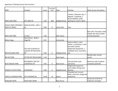
Appendix A: <strong>Flathead</strong> <strong>County</strong> Park Inventory<br />
PARK Location Acres<br />
AERO LANE PARK OFF AERO LN 2.00 .864 Neighborhood<br />
ASHLEY CREEK GREENBELT<br />
RAILS TO TRAILS<br />
NEAR KALISPELL, HWY 2<br />
W 9.00 9 Linear Park Trail<br />
BASS LAKE PARK Creston<br />
West Glacier ‐ Belton‐<br />
1.00 Open Space<br />
Belton‐Stage<br />
Stage Rd. 9.97 Community<br />
BEN WILLIAMS PARK<br />
One mile southwest of<br />
Lakeside OFF BLACKTAIL<br />
RD 5.00 5 Neighborhood<br />
BIG SKY PARK OFF BIG SKY BOULEVARD 1.00 Open Space<br />
BLUE GROUSE PARK<br />
BITTERROOT LAKE OFF<br />
LODGEPOLE DR 4.00 4 Boat Access<br />
CAMELOT ESTATE PARK EVERGREEN 4.00 4 Neighborhood<br />
CARLYLE JOHNSON PARK OFF SHAWNEE DR 14.00 14 Sports<br />
CAROLINE POINT DOCK BOAT RAMP Boat Access<br />
Developed<br />
Acres Type Facilities Water Access Description<br />
1<br />
2 toilets, 2 bleacher sets, 2<br />
dugouts, 1 backstop, 1<br />
fenced ballfield, public<br />
parking lot, 4 picnic tables<br />
8 picnic tables; 1 park<br />
shelter; 2 outhouses; 1 well<br />
and water system;<br />
playground equipment, 1<br />
volleyball court, horseshoe<br />
pits<br />
Bass Lake: Two parks; steep<br />
hillside with dense timber<br />
and brush growth<br />
Spring Creek; marshy<br />
access<br />
Concrete boat ramp, Bitterroot Lake; Excellent<br />
restrooms,<br />
recreation potential<br />
Playground equipment,<br />
picnic tables, fishing, and<br />
benches<br />
4 baseball and 3 soccer<br />
fields, restrooms, playgound<br />
equipment.<br />
Access too small to be<br />
useful for recreation
Appendix A: <strong>Flathead</strong> <strong>County</strong> Park Inventory<br />
Church‐Slough<br />
COUNTRY ESTATES PARK<br />
Lower Valley Rd Carver<br />
Sudivision<br />
ENDS OF GARDEN DRIVE<br />
AND DAIRY DRIVE 4.00 Open Space<br />
CREE LAKE SOUTH PARK MANY LAKES Open Space<br />
DAN LAKE PARK<br />
DEMERSVILLE CEMETARY<br />
CRESTON 1.00 Open Space<br />
PARK KALISPELL‐SOUTH 24.70 Open Space Cemetery<br />
Cree Lake: Swampy low<br />
area on east side of Cree<br />
Lake<br />
Gully at the north end of<br />
Dan Lake, open area<br />
DOUBLE LAKE PARK CRESTON 1.00 Open Space Dan Lake; small open gully<br />
EAGLE POINT PARK WHITEFISH 2.00 2<br />
Boat Access,<br />
Fishing Access Floating dock<br />
Whitefish Lake; Cliff<br />
prevents easy access;<br />
accessible by boat or foot<br />
EAST BASS LAKE PARK CRESTON 3.00 Open Space Many Lakes; Poor shoreline<br />
EAST BLANKENSHIP RIVER Blankenship Rd. & West<br />
Boat Access,<br />
ACCESS<br />
Glacier<br />
Bernard Road and East<br />
1.00 1 Fishing Access Restrooms, picnic tables.<br />
EVERGREEN LIONS PARK Evergreen Drive 3.00 3 Neighborhood<br />
FLATHEAD RIVER<br />
Floating Dock, Boat launch,<br />
<strong>Flathead</strong> River; beach area<br />
poor; good recreational<br />
RANCHETTES PARK CRESTON 1.00 1 Boat Access benches, picnic table.<br />
Swim area and dock, boat<br />
dock and ramp, benches,<br />
potential<br />
restrooms, Horshoes, shape Foys Lake: 700 feet of lake<br />
swim dock, swim area + shore, excellent<br />
Boat Access, beach, boat dock, 2 recreational potential,<br />
FOYS LAKE PARK OFF MT HWY 404<br />
Community bathrooms<br />
beach area is excellent<br />
2
Appendix A: <strong>Flathead</strong> <strong>County</strong> Park Inventory<br />
FOYS SCHOOL_FOYS LAKE<br />
COMMUNITY CENTER 2.00 2 Special Use<br />
GILBERT LAKE NORTH PARK Creston 1.00 Open Space<br />
GREEN ACRES PARK W END OF HAVEN CT<br />
VALLEY MEADOW AIR<br />
STRIP BTWN BEAR TR<br />
2.00 Neighborhood<br />
HAPPY VALLEY PARK AND COUGAR TR 24.00 Community<br />
Four miles southwest of<br />
Kalispell on Foys Lake<br />
Community<br />
HERRON PARK<br />
Road 120.00 120 Special Use<br />
HEWITT PARK West Glacier 1.00 Open Space<br />
HILLCREST PARK WHITEFISH STAGE RD 7.00 7 Sports Park<br />
HILLTOP TERRACE PARK Columbia Falls, west<br />
REACHABLE AT END OF<br />
MOUNTAIN DR OR<br />
CANYON ROAD OR<br />
2.00 2 Neighborhood<br />
HUNGRY HORSE "H" PARK SOUTHFORK DR 7.40 Open Space<br />
Large public meeting room,<br />
2 restrooms, kitchen,<br />
basement, large deck and<br />
picnic tables outside,<br />
Horshoes pits, Volleyball net<br />
Gilbert Lake: small steep<br />
hillside on the southern<br />
end of the lake; possible<br />
surplus<br />
Playground equipment,<br />
picnic tables, grill. Possible Surplus<br />
Playground equipment,<br />
picnic tables,<br />
HUNGRY HORSE HIGHWAY Hungry Horse 1.50 1.5 Open Space Picnic tabels<br />
3<br />
Restrooms, equestrian Birch Creek: small water<br />
jumps, horse stalls, dressage body that wanders through<br />
arenas, hiking trails, cross the meadow, then goes<br />
country ski trails, sledding, 2 underground. Possible<br />
shelters<br />
development<br />
2 softball fields, bleachers,<br />
dugouts restrooms,<br />
playground equipment, 2<br />
soccer fields.<br />
Playground equipment,<br />
basketball court.
Appendix A: <strong>Flathead</strong> <strong>County</strong> Park Inventory<br />
JOHN LAKE Creston 4.00 Open Space<br />
KATHY LAKE PARK Creston 3.00 Open Space<br />
KELSEY CUMMINGS PARK Marion, Bitterroot Lake 3.00 3 Boat Access Picnic tables<br />
KINGS LOOP PARK FISHING<br />
ACCESS Evergreen 5.00 5 Neighborhood Fishing , picnicking.<br />
KOKANEE BEND PARK END OF KOKANEE DRIVE 4.00 4 Neighborhood<br />
LAKE HILLS PARK<br />
LAKESIDE ‐ ADAMS PARK<br />
Bigfork 4.00 Neighborhood<br />
(BOAT RAMP) BOAT RAMP Boat Access<br />
LAKESIDE BOAT RAMP END OF BIERNEY CR RD Boat Access<br />
LAZY BAY PARK<br />
DELRAY RD/WHITEFISH<br />
LAKE 3.00 Boat Access<br />
LEISURE ISLAND PARK Kalispell, east side 137.00 3<br />
LEISURE LANE Kalispell Open Space<br />
LITTLE BITTERROOT LAKE<br />
ACCESS Marion 1.00 Open Space<br />
Baseball field, playground<br />
equipment.<br />
Boat ramp, small parking,<br />
picnic area<br />
Boat Access,<br />
Open Space Boat ramp, picnicking<br />
4<br />
John Lake: Large area with<br />
potential<br />
Kathy Lake: steep timbered<br />
bowl at east end of lake<br />
Little Bitterroot Lake;<br />
excellent recreation<br />
potential<br />
Whitefish River: river<br />
bottom area that is<br />
reasonably open<br />
<strong>Flathead</strong> River: site is near<br />
the <strong>Flathead</strong> River and<br />
Kokanee Bend Fishing<br />
Access owned by the FWP<br />
<strong>Flathead</strong> Lake: 50 feet of<br />
lake frontage<br />
Whitefish Lake; Lazy Creek:<br />
swamp area on north<br />
Whitefish Lake<br />
<strong>Flathead</strong> and Stillwater<br />
Rivers: wooded island<br />
between rivers<br />
<strong>Flathead</strong> and Stillwater<br />
Rivers: island between<br />
rivers<br />
Bitterroot Lake: lake<br />
access, south side of lake;<br />
cut from forest; quite<br />
steep; limited parking
Appendix A: <strong>Flathead</strong> <strong>County</strong> Park Inventory<br />
MANY LAKES VACATION<br />
VILLAGE Creston<br />
MARTIN CITY PARK Martin City<br />
BETWEEN MEADOW<br />
HILLS RD AND YODELIN<br />
2.00 2 Neighborhood<br />
MEADOW HILLS PARK RIDGE 3.00 3 Neighborhood<br />
Ball fields, playground<br />
equipment.<br />
Playground equipment,<br />
picnic tables.<br />
MEREDITH LAKE PARK Creston 10.00 Open Space<br />
MISSION VILLAGE Kalispell, Whitefish Stage<br />
Playground equipment,<br />
OVERLOOK PARK Road<br />
Kalispell, north on Four<br />
4.20 4.2 Neighborhood picnic tables, benches.<br />
NORTH HAVEN PARK Mile Drive<br />
Essex, west (north of Hwy<br />
1.00 1 Pocket Playground equipment.<br />
PAOLA PARK<br />
2) 4.00 Neighborhood<br />
PARMA PARK<br />
PLEASANT VIEW<br />
PARK DR ‐ ESSEX 3.00 Open Space<br />
HOMESITES PARK Creston, Lake Blaine 7.00 Open Space<br />
PLUMMERS LAKE PARK Creston 1.00 Open Space<br />
POTOCZNY PARK<br />
OFF HOLT DRIVE ‐<br />
BIGFORK 3.00 3 Neighborhood<br />
RAILS TO TRAILS Columbia Falls to Somers<br />
OFF HIGHLINE BLVD IN<br />
22.00 Linear Park<br />
SCENIC VIEW PARK BELTON 8.00 Open Space<br />
SILVER SHADOW PARK Evergreen, north 1.00 1 Pocket<br />
5<br />
Baseball field, restrooms,<br />
play equipment, picnic<br />
tables.<br />
2.5 miles of trail starting at<br />
Meridian and Appleway Dr<br />
and running West to Spring<br />
Creek Road and Hwy 2.<br />
Playground equipment,<br />
picnic tables, small ballfield<br />
with backstop.<br />
Meredith Lake: large<br />
woody gully surrounding<br />
lake<br />
Plummers Lake: long,<br />
narrow stretch of shoreline<br />
and hillside
Appendix A: <strong>Flathead</strong> <strong>County</strong> Park Inventory<br />
SKYLINE PARK (ROY<br />
COOPER PARK) Polebridge 3.00 3 Neighborhood Ballfield, toilet<br />
SOMERS 5N & 5J PARK Somers 0.00<br />
Playground equipment,<br />
SUNRISE TERRACE PARK OFF HARBIN HILL ROAD 2.00 2 Neighborhood benches.<br />
SWAN MEADOWS<br />
MEADOWS OFF SWAN<br />
RETREAT RD+A24 0.69 Open Space<br />
SWIMMING LAKE COURT Creston 2.00 Open Space<br />
TAMARACK Creston Fishing Access<br />
TROUTBECK RISE PARK Lakeside 5.00 Open Space<br />
VETVILLE PARK Columbia Falls<br />
CORNER OF JUANITA<br />
10.80 Open Space<br />
WAPITI PARK<br />
WAY/DALE DR 3 Open Space<br />
WEST BLANKENSHIP RIVER Blankenship Rd. &<br />
Boat Access,<br />
ACCESS<br />
WHITEFISH BOAT ACCESS<br />
<strong>Flathead</strong> River 3.7 3.7 Fishing Access 2 Restrooms, picnic tables.<br />
PARK OFF WEST LAKESHORE DR<br />
Edgarton School to City<br />
0 Boat Access Dock, restrooms, benches.<br />
Whitefish Stage<br />
limits<br />
515.26<br />
Linear Park<br />
6<br />
Two small streams and a<br />
shallow pond<br />
Swan River: an open<br />
meadow on the Swan River<br />
Swimming Lake: timbered<br />
south facing slope to lake<br />
Tamarack Lake: sizeable<br />
bass population; one of the<br />
best sites in Many Lakes,<br />
gentle grassy slope to a<br />
beautiful lake (4 individual<br />
parks)