Annual Report - BIEAP FREMP 2011/2012 - the BIEAP and FREMP ...
Annual Report - BIEAP FREMP 2011/2012 - the BIEAP and FREMP ...
Annual Report - BIEAP FREMP 2011/2012 - the BIEAP and FREMP ...

You also want an ePaper? Increase the reach of your titles
YUMPU automatically turns print PDFs into web optimized ePapers that Google loves.
LIONS BAY<br />
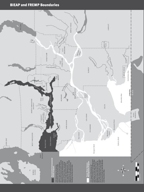
<strong>BIEAP</strong> <strong>and</strong> <strong>FREMP</strong> Boundaries<br />
Pitt Lake<br />
NORTH VANCOUVER<br />
DISTRICT<br />
WEST VANCOUVER<br />
ANMORE<br />
BOWEN<br />
ISLAND<br />
Indian Arm<br />
Deep<br />
Cove<br />
Point<br />
Atkinson<br />
Burrard Inlet<br />
COQUITLAM<br />
BELCARRA<br />
Seymour River<br />
Capilano River<br />
Lynn Creek<br />
NORTH<br />
VANCOUVER<br />
CITY<br />
Outer Harbour Inner Harbour<br />
Central Harbour<br />
Pitt River<br />
Coquitlam River<br />
Burrard Inlet Environmental<br />
Action Program<br />
English<br />
Bay<br />
PORT<br />
MOODY<br />
False Creek<br />
Alouette River<br />
PORT<br />
COQUITLAM<br />
BURNABY<br />
PITT<br />
MEADOWS<br />
Brunette River<br />
VANCOUVER<br />
MAPLE RIDGE<br />
Fraser River<br />
190 kilometres of marine<br />
foreshore <strong>and</strong> all <strong>the</strong> tidal<br />
waters east of a line between<br />
<strong>the</strong> sou<strong>the</strong>rnmost point of point<br />
Atkinson <strong>and</strong> <strong>the</strong> westernmost<br />
point of Point Grey, including<br />
False Creek <strong>and</strong> all of Indian<br />
Arm <strong>and</strong> Port Moody Arm, <strong>and</strong><br />
extending to <strong>the</strong> upstream tidal<br />
influence of all watercourses<br />
feeding into Burrard Inlet.<br />
Kanaka Creek<br />
NEW<br />
WESTMINSTER<br />
Barnston<br />
Isl<strong>and</strong><br />
North Arm<br />
Sea Isl<strong>and</strong><br />
Annacis<br />
Isl<strong>and</strong><br />
Lulu Isl<strong>and</strong><br />
Serpentine River<br />
SURREY<br />
South Arm<br />
RICHMOND<br />
Sturgeon Bank<br />
Fraser River Estuary<br />
Management Program<br />
155 square kilometres of<br />
estuary foreshore including l<strong>and</strong><br />
<strong>and</strong> water on <strong>the</strong> wet side of <strong>the</strong><br />
dykes of <strong>the</strong> Fraser River from<br />
Kanaka Creek <strong>and</strong> <strong>the</strong> outlet of<br />
Pitt Lake downstream to Georgia<br />
Strait including <strong>the</strong> outer banks<br />
from Point Grey to <strong>the</strong> US Border<br />
<strong>and</strong> Boundary Bay.<br />
LANGLEY<br />
CITY<br />
DELTA<br />
LANGLEY<br />
Westham<br />
Isl<strong>and</strong><br />
Nicomekl River<br />
Brunswick Point<br />
Roberts Bank<br />
Boundary Bay<br />
River<br />
Campbell<br />
WHITE ROCK<br />
Semiahmoo Bay<br />
CANADA<br />
U.S.A.<br />
POINT<br />
ROBERTS<br />
MILES<br />
1 2 3 4<br />
1 2 3 4 5 6<br />
KILOMETRES