

Review of Greenland activities 1997 - Geus
Review of Greenland activities 1997 - Geus
Review of Greenland activities 1997 - Geus

Create successful ePaper yourself
Turn your PDF publications into a flip-book with our unique Google optimized e-Paper software.
12<br />
14<br />
10<br />
Nuuk<br />
6<br />
1<br />
9<br />
8<br />
A<br />
7<br />
13<br />
11<br />
Inland<br />
Ice<br />
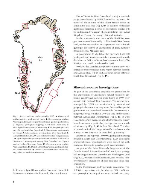
Fig. 1. Survey <strong>activities</strong> in <strong>Greenland</strong> in <strong>1997</strong>. A: Commercial<br />
drilling activity, north-east <strong>of</strong> Nuuk; 1: Ore geological studies,<br />
Washington Land; 2: Nioghalvfjerdsfjorden glaciological studies;<br />
3: Regional geological mapping, North-East <strong>Greenland</strong>; 4:<br />
Geophysical survey south <strong>of</strong> Mestersvig; 5: Marine geological survey<br />
<strong>of</strong>fshore South-East <strong>Greenland</strong>; 6: Plate tectonic studies north<br />
<strong>of</strong> Ivittuut; 7: Lake sediment investigations, West <strong>Greenland</strong>; 8:<br />
Ancient life studies, Isua; 9: Lake sediment studies, Kangerlussuaq;<br />
10: Hydrological and glaciological reconnaissance, north-east <strong>of</strong><br />
Sisimiut; 11: Aeromagnetic survey, West <strong>Greenland</strong>; 12: Hydrocarbon<br />
studies, Nuussuaq Basin; 13: Ore geochemical studies,<br />
West <strong>Greenland</strong>; 14: Danish Lithosphere Centre, geological studies,<br />
West <strong>Greenland</strong>; 15: Danish Lithosphere Centre seismic survey,<br />
<strong>of</strong>fshore South-East <strong>Greenland</strong>.<br />
for Research, Jytte Hilden, and the <strong>Greenland</strong> Home Rule<br />
Government Minister for Research, Marianne Jensen.<br />
5<br />
2<br />
15<br />
3<br />
4<br />
East <strong>of</strong> Nuuk in West <strong>Greenland</strong>, a major research<br />
project coordinated by GEUS, focused on the search for<br />
traces <strong>of</strong> life in some <strong>of</strong> the oldest known rocks on<br />
Earth in the Isua area (Fig. 1, 8). In addition to detailed<br />
geological mapping a series <strong>of</strong> specialised studies will<br />
be undertaken by a group <strong>of</strong> scientists from the United<br />
Kingdom, France, Germany, USA and Australia.<br />
In the northern border zone <strong>of</strong> the Ketilidian orogen<br />
north-east <strong>of</strong> Ivittuut (Fig. 1, 6) in South-West <strong>Greenland</strong>,<br />
studies undertaken in cooperation with a British<br />
geologist are aimed at elucidation <strong>of</strong> plate tectonic<br />
processes 1800 Ma years ago.<br />
A programme to digitalise the Survey’s 1:500 000<br />
geological map sheets, undertaken in cooperation with<br />
the Minerals Office in Nuuk, has been completed; CD-<br />
ROM products will be released in 1998.<br />
Work by the Danish Lithosphere Centre in <strong>1997</strong> was<br />
limited to onshore studies in the region between Sisimiut<br />
and Aasiaat (Fig. 1, 14), and a seismic survey <strong>of</strong>fshore<br />
South-East <strong>Greenland</strong> (Fig. 1, 15).<br />
Mineral resource investigations<br />
As part <strong>of</strong> the continuing emphasis on promotion for<br />
the exploration <strong>of</strong> <strong>Greenland</strong>’s natural resources, airborne<br />
geophysical surveys were flown in <strong>1997</strong> over<br />
areas in both East and West <strong>Greenland</strong>. The surveys were<br />
managed by GEUS, and carried out by international<br />
geophysical contractors; they were financed by special<br />
grants from the <strong>Greenland</strong> Home Rule Government. A<br />
magnetic survey was flown over the land and sea areas<br />
between Aasiaat and Uummannaq (Fig. 1, 11) in West<br />
<strong>Greenland</strong>, and a magnetic and electromagnetic survey<br />
was flown over a particularly prospective area south<br />
<strong>of</strong> Mestersvig (Fig. 1, 4) in East <strong>Greenland</strong>. The data<br />
acquired are included in geoscientific databases at the<br />
Survey, where they can be consulted by industry.<br />
As part <strong>of</strong> the regional 1:500 000 geological mapping<br />
project in North-East <strong>Greenland</strong> (Fig. 1, 3), geological<br />
and geochemical investigations were carried out with<br />
particular interest in possible gold mineralisation.<br />
As part <strong>of</strong> the Polar Research Programme <strong>of</strong> the<br />
Danish Natural Science Research Council, ore geological<br />
investigations were carried out in Washington Land<br />
(Fig. 1, 1), western North <strong>Greenland</strong>, and revealed hitherto<br />
unknown indications <strong>of</strong> zinc, lead and silver mineralisation.<br />
In the Uummannaq and Upernavik kommunes (Fig.<br />
1, 13) in cooperation with the Minerals Office in Nuuk,<br />
ore geological investigations were carried out, partly<br />
8


