

Review of Greenland Avtivities 2001 - Aeromagnetic survey ... - Geus
Review of Greenland Avtivities 2001 - Aeromagnetic survey ... - Geus
Review of Greenland Avtivities 2001 - Aeromagnetic survey ... - Geus

You also want an ePaper? Increase the reach of your titles
YUMPU automatically turns print PDFs into web optimized ePapers that Google loves.
<strong>Aeromagnetic</strong> <strong>survey</strong> in central West <strong>Greenland</strong>:<br />
project Aeromag <strong>2001</strong><br />
Thorkild M. Rasmussen<br />
The series <strong>of</strong> government-funded geophysical <strong>survey</strong>s in<br />
<strong>Greenland</strong> was continued during the spring and summer<br />
<strong>of</strong> <strong>2001</strong> with a regional aeromagnetic <strong>survey</strong> north <strong>of</strong><br />
Uummannaq, project Aeromag <strong>2001</strong> (Fig. 1). The <strong>survey</strong><br />
added about 70 000 line kilometres <strong>of</strong> high-quality magnetic<br />
measurements to the existing database <strong>of</strong> modern<br />
airborne geophysical data from <strong>Greenland</strong>. This database<br />
includes both regional high-resolution aeromagnetic<br />
<strong>survey</strong>s and detailed <strong>survey</strong>s with combined electromagnetic<br />
and magnetic airborne measurements.<br />
High-quality magnetic data are now available for all<br />
the ice-free area <strong>of</strong> West and South <strong>Greenland</strong> from the<br />
southern tip <strong>of</strong> <strong>Greenland</strong> to Upernavik Kujalleq/Søndre<br />
Upernavik (Fig. 1). The total <strong>survey</strong>ed area with highresolution<br />
magnetic data is 250 000 km 2 and corresponds<br />
to a total <strong>of</strong> 515 000 line kilometres. Detailed<br />
<strong>survey</strong>s with combined electromagnetic and magnetic<br />
measurements were carried out in six separate <strong>survey</strong>s<br />
in selected areas <strong>of</strong> high mineral potential during project<br />
AEM <strong>Greenland</strong> 1994–1998, a total <strong>of</strong> 75 000 line<br />
kilometres. Descriptions <strong>of</strong> the previous <strong>survey</strong>s can be<br />
found in Thorning (1993), Stemp & Thorning (1995),<br />
Thorning & Stemp (1996, 1998), Stemp (1997), Rasmussen<br />
& Thorning (1999), Rasmussen & van Gool (2000)<br />
and Rasmussen et al. (<strong>2001</strong>).<br />
The primary objective <strong>of</strong> the government-funded airborne<br />
geophysical programme is to provide the industry<br />
and the geoscientific community with modern data<br />
that are relevant to the exploration for mineral resources<br />
and for the general understanding <strong>of</strong> the geology <strong>of</strong><br />
<strong>Greenland</strong>. Most <strong>of</strong> the previous <strong>survey</strong>s have covered<br />
onshore areas. However, the <strong>survey</strong> in <strong>2001</strong>, like the<br />
<strong>survey</strong> in 1997 in the Disko Bugt region, also included<br />
significant <strong>of</strong>fshore areas. Approximately one third <strong>of</strong><br />
the <strong>2001</strong> <strong>survey</strong> region is <strong>of</strong>fshore, and includes an area<br />
well known for its hydrocarbon potential (Christiansen<br />
et al. 1995, 2000).<br />
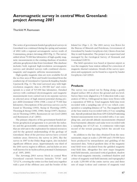
The Aeromag <strong>2001</strong> <strong>survey</strong> block in central West<br />
<strong>Greenland</strong> extends between latitudes 70°30´ and<br />
72°12´N, covering the entire ice-free land area together<br />
with a part <strong>of</strong> the <strong>of</strong>fshore area and the border <strong>of</strong> the<br />
Inland Ice (Figs 1, 2). The <strong>2001</strong> <strong>survey</strong> was flown for<br />
the Bureau <strong>of</strong> Minerals and Petroleum, Government <strong>of</strong><br />
<strong>Greenland</strong> by Sander Geophysics Ltd, Ottawa from late<br />
May to mid-September. The project was supervised and<br />
managed by the Geological Survey <strong>of</strong> Denmark and<br />
<strong>Greenland</strong> (GEUS).<br />
The field operation was based at Qaarsut airport as<br />
was the magnetic base station utilised for correction <strong>of</strong><br />
magnetic diurnal variations. Details <strong>of</strong> the <strong>survey</strong> operation<br />
and equipment can be found in a report by Sander<br />
Geophysics Ltd (2002).<br />
Products<br />
The <strong>survey</strong> was carried out by flying along a gently<br />
draped surface 300 m above the ground and sea level.<br />
Survey lines were aligned in a N–S direction with a separation<br />
<strong>of</strong> 500 m. Orthogonal tie-lines were flown with<br />
a separation <strong>of</strong> 5000 m. Total magnetic field data were<br />
recorded with a sampling rate <strong>of</strong> 0.1 sec which corresponds<br />
to a sampling distance <strong>of</strong> 7 m. The magnetic field<br />
at the base station was recorded with a 0.5 sec sampling<br />
rate. Aircraft positional data from GPS (Global Positioning<br />
System) measurements were recorded with a 1 sec sampling<br />
rate, and aircraft altitude measurements obtained<br />
from barometric altimeter and radar were recorded with<br />
a sampling rate <strong>of</strong> 0.25 sec. A continuous video-tape<br />
record <strong>of</strong> the terrain passing below the aircraft was<br />
made.<br />
In addition to the line data obtained from the measurements,<br />
maps at scales 1:250 000 and 1:50 000 have<br />
been produced by interpolation and gridding <strong>of</strong> the<br />
measured data. Vertical gradient data <strong>of</strong> the magnetic<br />
total field were calculated from the gridded magnetic<br />
total field data. Altogether five new maps (magnetic<br />
total field intensity, associated vertical gradient, shadow<br />
<strong>of</strong> the total magnetic intensity, combined shadow and<br />
colour <strong>of</strong> magnetic total field intensity and topography)<br />
at scale 1:250 000 <strong>of</strong> the entire <strong>survey</strong> area and three<br />
sets <strong>of</strong> maps (colour and contours <strong>of</strong> magnetic total<br />
Geology <strong>of</strong> <strong>Greenland</strong> Survey Bulletin 191, 67–72 (2002) © GEUS, 2002<br />
67
72°30´<br />
Aeromag <strong>2001</strong><br />
50 km<br />
Upernavik Kujalleq<br />
Inngia<br />
Inland<br />
Ice<br />
72°<br />
Svartenhuk Halvø<br />
Nuugaatsiaq<br />
71°30´<br />
Upernavik Ø<br />
Ubekendt Ejland<br />
Maarmorilik<br />
71°<br />
Nuussuutaa<br />
Itilli fault<br />
Uummannaq<br />
Qaarsut<br />
Nuussuaq<br />
56° 54° 52°<br />
70°30´<br />
50°<br />
70°<br />
50° 30°<br />
10°<br />
Canada<br />
80°<br />
nT<br />
<strong>Greenland</strong><br />
500 km<br />
75°<br />
70°<br />
65°<br />
60°<br />
510<br />
380<br />
305<br />
245<br />
195<br />
160<br />
125<br />
100<br />
80<br />
60<br />
40<br />
20<br />
0<br />
–20<br />
– 45<br />
– 70<br />
– 105<br />
– 175<br />
– 340<br />
50°<br />
30°<br />
Fig. 1. Coverage <strong>of</strong> government-financed aeromagnetic <strong>survey</strong>s in western <strong>Greenland</strong> during the period 1992–<strong>2001</strong>. The location <strong>of</strong><br />
the aeromagnetic <strong>survey</strong> in <strong>2001</strong> is circumscribed by a black line.<br />
68
56° 54° 52°<br />
72°<br />
72°<br />
71°30′<br />
71°<br />
70°30′<br />
50 km<br />
71°30′<br />
71°<br />
nT<br />
608<br />
364<br />
233<br />
150<br />
78<br />
35<br />
6<br />
– 13<br />
– 29<br />
– 43<br />
– 55<br />
– 66<br />
– 75<br />
– 84<br />
– 92<br />
– 100<br />
– 108<br />
– 117<br />
– 124<br />
– 131<br />
– 138<br />
– 145<br />
– 151<br />
– 159<br />
– 166<br />
– 175<br />
– 184<br />
– 194<br />
– 206<br />
– 222<br />
– 242<br />
– 271<br />
– 325<br />
– 387<br />
– 460<br />
– 546<br />
– 653<br />
– 815<br />
56° 54° 52°<br />
Fig. 2. Magnetic total field intensity with shaded relief for the area in central West <strong>Greenland</strong> covered by project Aeromag <strong>2001</strong>.<br />
The location <strong>of</strong> the aeromagnetic <strong>survey</strong> in <strong>2001</strong> is circumscribed by a grey line and the new data have been merged with data from<br />
project Aeromag 1997.<br />
field intensity and flight path) each comprising 32 sheets<br />
at scale 1:50 000 are included in the map series.<br />
The gridded magnetic total field data from Aeromag<br />
<strong>2001</strong> are shown in Fig. 2. The data have been merged<br />
with those from the Aeromag 1997 project. The International<br />
Geomagnetic Reference Field corresponding<br />
to the date <strong>of</strong> measurement has been subtracted from<br />
the data. Shaded relief data, superimposed on the magnetic<br />
total field data, have been modelled by using a lightsource<br />
illumination from north with an inclination <strong>of</strong> 45°.<br />
The magnetic anomalies are in the range from –2500 to<br />
2000 nT. The calculated vertical gradient <strong>of</strong> the magnetic<br />
total field is shown in Fig. 3 for the merged data set.<br />
Some implications <strong>of</strong> the new geophysical data for the<br />
interpretation <strong>of</strong> the geology are given below after a short<br />
introduction to the geology.<br />
Geology <strong>of</strong> the <strong>survey</strong>ed area<br />
Five geological maps at scale 1:100 000 have been published<br />
<strong>of</strong> the <strong>survey</strong>ed area by the Survey; a descriptive<br />
text for three <strong>of</strong> the map sheets is given by<br />
Henderson & Pulvertaft (1987). The <strong>survey</strong>ed area<br />
between Uummannaq and Upernavik Kujalleq/Søndre<br />
Upernavik comprises Archaean crystalline basement<br />
rocks overlain by a several kilometres thick succession<br />
<strong>of</strong> Palaeoproterozoic supracrustal rocks; they are intruded<br />
by a Palaeoproterozoic granitic complex. Minor units<br />
<strong>of</strong> down-faulted Cretaceous sediments occur, and<br />
Palaeogene plateau basalts are prominent onshore and<br />
<strong>of</strong>fshore. The Precambrian rocks have been correlated<br />
with similar rocks on Baffin Island in Canada, and were<br />
folded and metamorphosed during the Hudsonian<br />
69
56° 54°<br />
52°<br />
72°<br />
72°<br />
nT<br />
71°30′<br />
71°<br />
70°30′<br />
50 km<br />
71°30′<br />
71°<br />
0.335<br />
0.223<br />
0.163<br />
0.122<br />
0.092<br />
0.068<br />
0.051<br />
0.037<br />
0.027<br />
0.019<br />
0.014<br />
0.010<br />
0.006<br />
0.004<br />
0.001<br />
– 0.001<br />
– 0.003<br />
– 0.005<br />
– 0.007<br />
– 0.009<br />
– 0.011<br />
– 0.014<br />
– 0.016<br />
– 0.021<br />
– 0.027<br />
– 0.035<br />
– 0.049<br />
– 0.077<br />
– 0.126<br />
– 0.210<br />
– 0.402<br />
56° 54° 52°<br />
Fig. 3. Calculated vertical gradient <strong>of</strong> the total magnetic field intensity with shaded relief for the area in central West <strong>Greenland</strong> covered<br />
by project Aeromag <strong>2001</strong>. The location <strong>of</strong> the aeromagnetic <strong>survey</strong> in <strong>2001</strong> is circumscribed by a grey line and the new data have<br />
been merged with data from project Aeromag 1997.<br />
orogeny at around 1.85 Ga, and intruded by a 1.65 Ga<br />
old swarm <strong>of</strong> dolerite dykes.<br />
The Palaeoproterozoic metasediments (the Karrat<br />
Group) host the now exhausted Black Angel Pb-Zn ore<br />
bodies (13.5 mill. tonnes ore at 4.0% Pb and 12.3% Zn)<br />
which were mined from 1973–1990. Similar marblehosted<br />
lead-zinc occurrences at other localities indicate<br />
an additional potential for this type <strong>of</strong> mineralisation.<br />
The clastic facies <strong>of</strong> the Karrat Group include extensive<br />
sulphide facies iron formation and vein-type base and<br />
precious metals mineralisation, and <strong>of</strong>fer a potential for<br />
shale-hosted massive sulphides and turbidite-hosted goldbearing<br />
veins and shear zones (Thomassen 1992).<br />
The Karrat Group crops out within the Rinkian Belt<br />
<strong>of</strong> central West <strong>Greenland</strong>, a region that is characterised<br />
by gneiss domes and fold nappes with sheath-like geometry<br />
and flat-lying axial surfaces that affect both Archaean<br />
basement gneisses and the Palaeoproterozoic Karrat<br />
Group. Grocott & Pulvertaft (1990) identified seven<br />
phases in the tectonic evolution <strong>of</strong> the region, <strong>of</strong> which<br />
three involve extension and four compression.<br />
The southern and south-western part <strong>of</strong> the <strong>survey</strong>ed<br />
region preserves extensive areas <strong>of</strong> Palaeogene volcanic<br />
rocks, related to the plate break-up between<br />
<strong>Greenland</strong> and Baffin Island. These volcanic rocks represent,<br />
together with similar volcanic rocks on the<br />
Canadian side <strong>of</strong> Davis Strait and on the east coast <strong>of</strong><br />
<strong>Greenland</strong>, the results <strong>of</strong> mantle plume activity along<br />
the track <strong>of</strong> the present Iceland mantle plume (Storey<br />
et al. 1998). In the <strong>survey</strong>ed area volcanic activity started<br />
in mid-Paleocene time with deposition <strong>of</strong> the Vaigat<br />
Formation. The earliest volcanics were extruded below<br />
sea level as hyaloclastite breccias, while most later volcanism<br />
was subaerial. The Vaigat Formation is dominated<br />
by picritic and other olivine-rich tholeiitic basalts;<br />
it is between 0 and 3 km thick on Svartenhuk Halvø<br />
and more than 5 km thick on Ubekendt Ejland (Hald<br />
& Pedersen 1975). In the northern part <strong>of</strong> the basalt-<br />
70
covered area, the Vaigat Formation was followed by<br />
deposition <strong>of</strong> about 50 m <strong>of</strong> fluvio-lacustrine sediments<br />
and hyaloclastite breccias. The succeeding volcanic<br />
rocks <strong>of</strong> the Svartenhuk Formation are characterised<br />
by plagioclase-porphyritic and aphyric basalts, and have<br />
a minimum thickness <strong>of</strong> 2.8 km. Determinations <strong>of</strong> the<br />
magnetic palaeodirection and palaeointensity from samples<br />
<strong>of</strong> the Vaigat Formation at Nuussuutaa on Nuussuaq<br />
have been presented by Riisager & Abrahamsen (1999)<br />
and Riisager et al. (1999). The lower part <strong>of</strong> the Vaigat<br />
Formation (the Anaanaa Member and part <strong>of</strong> the<br />
Naujánguit Member) has normal magnetisation (C27N),<br />
whereas the upper part <strong>of</strong> the Vaigat Formation is<br />
reversely magnetised. Palaeomagnetic data for the<br />
Maligât Formation on Nuussuaq, a stratigraphic equivalent<br />
to the Svartenhuk Formation, yielded reverse magnetisation<br />
directions; a detailed chronostratigraphy has<br />
not yet been established. The Palaeogene volcanics are<br />
characterised by units <strong>of</strong> strongly reduced lavas with<br />
native iron, indicating a potential for Norilsk-type nickelcopper-PGM<br />
in the plateau basalt areas.<br />
Magnetic anomaly maps and geological<br />
implications<br />
The geophysical data illustrated in Figs 2 and 3 are considerably<br />
simplified representations <strong>of</strong> the original data<br />
sets, but major anomalies can be discerned. Onshore, six<br />
sub-parallel linear anomalies striking NNW–SSE cross<br />
the entire <strong>survey</strong> area. Some <strong>of</strong> these coincide with the<br />
locations <strong>of</strong> mapped Mesoproterozoic mafic dykes <strong>of</strong><br />
the Melville Bugt dyke swarm (Nielsen 1987). The dolerite<br />
dykes and thin layers <strong>of</strong> hornblende schist and amphibolite<br />
at many inland locations (Henderson & Pulvertaft<br />
1987) are seen very clearly in the magnetic response.<br />
Elongated anomalies with variable strikes between<br />
40–65° and with distinct minimum magnetic total field<br />
values are visible in the eastern half <strong>of</strong> Figs 2 and 3.<br />
These structures, many in areas covered by ice, appear<br />
not to have been deformed, which implies that they are<br />
younger than the Rinkian orogeny. Of the five anomalies<br />
<strong>of</strong> this type, the most prominent is a NE–SW feature<br />
with its south-western termination at Upernivik Ø.<br />
This anomaly may be an extension <strong>of</strong> the Itilli fault that<br />
crosses the westernmost part <strong>of</strong> Nuussuaq, and is marked<br />
by a sharp transition between positive and negative<br />
magnetic total field anomaly values. However, none <strong>of</strong><br />
these anomalies have so far been correlated with any<br />
confidence with known geological structures. The amplitudes<br />
<strong>of</strong> the anomalies are in the order <strong>of</strong> –150 nT and<br />
may have a magnetisation direction opposite to the<br />
present geomagnetic field direction.<br />
The Palaeogene basalts dominate the magnetic response<br />
in the coastal region and the <strong>of</strong>fshore part <strong>of</strong> the <strong>survey</strong>.<br />
Differences in polarities <strong>of</strong> the basalts are clearly defined<br />
by the low magnetic field values on Svartenhuk Halvø<br />
and the positive values west <strong>of</strong> Nuussuaq. On Ubekendt<br />
Ejland both the acid tuff/ignimbrite mapped on the<br />
western part <strong>of</strong> the island and the granite intrusion on<br />
the southern part are associated with positive magnetic<br />
anomalies.<br />
A distinct pattern <strong>of</strong> elongated, arcuate anomalies is<br />
dominated by low magnetic values. A similar anomaly<br />
pattern is not visible in the area with high magnetic field<br />
values. Comparison with mapped faults and dykes on<br />
Svartenhuk Halvø (Larsen & Pulvertaft 2000) shows an<br />
excellent correlation between the magnetic lineaments<br />
and geologically mapped structures, e.g. dykes and<br />
presumed non-exposed dykes associated with faults.<br />
However, basalt with normal magnetisation at depth in<br />
conjunction with vertical displacement along faults may<br />
also contribute to the anomalies. Topographic effects<br />
clearly contribute to the anomaly pattern, but are not<br />
sufficient to explain the anomalies. The distinct differences<br />
in anomaly pattern between areas with positive<br />
and negative magnetic anomaly values may be a result<br />
<strong>of</strong> difference in: (1) rheology due to difference in thermal<br />
state and pressure at the time <strong>of</strong> magmatic activity;<br />
(2) crustal composition; (3) volcanic source type. Firstly,<br />
the time span between the eruption <strong>of</strong> two different<br />
magma types may have been sufficiently long that the<br />
thermal state and pressure in the crust may have<br />
changed, leading to a difference in eruption style and<br />
in the amount <strong>of</strong> dyke intrusion. Secondly, the initial<br />
composition <strong>of</strong> the crust at the location <strong>of</strong> the magnetic<br />
high may have been unfavourable for the creation <strong>of</strong><br />
faults and intrusion <strong>of</strong> dykes. Thirdly, the basalt region<br />
with reverse magnetisation may be an amalgamation <strong>of</strong><br />
lavas from numerous eruptions with limited flow distances<br />
whereas the basalt with normal magnetisation<br />
may represent episodes with flows <strong>of</strong> a much larger<br />
extent. The magnetic data alone are not conclusive with<br />
respect to which <strong>of</strong> the three interpretations are correct.<br />
Establishment <strong>of</strong> age relationships between the<br />
two types <strong>of</strong> basalts is essential for a reliable interpretation.<br />
In particular, if the basalt <strong>of</strong> the area with high<br />
magnetic field values was extruded after the basalt causing<br />
low magnetic values, a mechanism must be found<br />
that explains why none <strong>of</strong> the elongated anomalies<br />
within the area <strong>of</strong> low magnetic intensity are truncated<br />
by basalts with normal magnetisation.<br />
71
Conclusions<br />
The aeromagnetic <strong>survey</strong> has revealed a number <strong>of</strong><br />
regional anomalies that must be accounted for when<br />
interpreting the geology <strong>of</strong> the region. Some <strong>of</strong> the major<br />
structures seen on the map <strong>of</strong> the magnetic total field intensity<br />
do not correlate with geologically mapped structures,<br />
and further geological and geophysical mapping, <strong>of</strong>fshore<br />
as well as onshore, is necessary in order to gain<br />
more insights into the structural development <strong>of</strong> the area.<br />
This paper has focused mainly on anomalies <strong>of</strong><br />
regional extent. Many local anomalies can be identified,<br />
but interpretation requires a thorough modelling <strong>of</strong><br />
topographic effects. A discussion <strong>of</strong> these anomalies and<br />
their implications for mineral prospecting in the region<br />
will be presented elsewhere.<br />
Acknowledgements<br />
Funding <strong>of</strong> the project was provided by the Bureau <strong>of</strong> Minerals<br />
and Petroleum, Government <strong>of</strong> <strong>Greenland</strong>. Thanks are due to<br />
Sander Geophysics Ltd for fulfilling all aspects <strong>of</strong> their contracts<br />
in a pr<strong>of</strong>essional manner. The airport manager, Ib Larsen, and<br />
staff at Qaarsut airport are thanked for co-operation and providing<br />
excellent conditions for the geophysical field work.<br />
References<br />
Christiansen, F.G., Marcussen, C. & Chalmers, J.A. 1995: Geophysical<br />
and petroleum geological activities in the Nuussuaq<br />
– Svartenhuk Halvø area 1994: promising results for an <strong>of</strong>fshore<br />
exploration potential. Rapport Grønlands Geologiske<br />
Undersøgelse 165, 32–41.<br />
Christiansen, F.G. et al. 2000: Petroleum geological activities in<br />
West <strong>Greenland</strong> in 1999. Geology <strong>of</strong> <strong>Greenland</strong> Survey Bulletin<br />
186, 88–96.<br />
Grocott, J. & Pulvertaft, T.C.R. 1990: The Early Proterozoic Rinkian<br />
Belt <strong>of</strong> central West <strong>Greenland</strong>. In: Lewry, J.F. & Stauffer, M.R.<br />
(eds): The Early Proterozoic Trans-Hudson Orogen <strong>of</strong> North<br />
America. Geological Association <strong>of</strong> Canada Special Paper 37,<br />
443–463.<br />
Hald, N. & Pedersen, A.K. 1975: Lithostratigraphy <strong>of</strong> the early<br />
Tertiary volcanic rocks <strong>of</strong> central West <strong>Greenland</strong>. Rapport<br />
Grønlands Geologiske Undersøgelse 69, 17–24.<br />
Henderson, G. & Pulvertaft, T.C.R. 1987: Geological map <strong>of</strong><br />
<strong>Greenland</strong>, 1:100 000, Mârmorilik 71 V.2 Syd, Nûgâtsiaq 71<br />
V.2 Nord, Pangnertôq 72 V.2 Syd. Descriptive text, 72 pp., 8<br />
plates. Copenhagen: Geological Survey <strong>of</strong> <strong>Greenland</strong>.<br />
Larsen, J.G. & Pulvertaft, T.C.R. 2000: The structure <strong>of</strong> the<br />
Cretaceous–Palaeogene sedimentary-volcanic area <strong>of</strong> Svartenhuk<br />
Halvø, central West <strong>Greenland</strong>. Geology <strong>of</strong> <strong>Greenland</strong><br />
Survey Bulletin 188, 40 pp.<br />
Nielsen, T.F.D. 1987: Mafic dyke swarms in <strong>Greenland</strong>: a review.<br />
In: Halls, H.C. & Fahrig, W.F. (eds): Mafic dyke swarms.<br />
Geological Association <strong>of</strong> Canada Special Paper 34, 349–360.<br />
Rasmussen, T.M. & Thorning, L. 1999: Airborne geophysical <strong>survey</strong>s<br />
in <strong>Greenland</strong> in 1998. Geology <strong>of</strong> <strong>Greenland</strong> Survey<br />
Bulletin 183, 34–38.<br />
Rasmussen, T.M. & van Gool, J.A.M. 2000: <strong>Aeromagnetic</strong> <strong>survey</strong><br />
in southern West <strong>Greenland</strong>: project Aeromag 1999. Geology<br />
<strong>of</strong> <strong>Greenland</strong> Survey Bulletin 186, 73–77.<br />
Rasmussen, T.M., Thorning, L., Stemp, R.W., Jørgensen, M.S. &<br />
Schjøth, F. <strong>2001</strong>: AEM <strong>Greenland</strong> 1994–1998 – summary report.<br />
Danmarks og Grønlands Geologiske Undersøgelse Rapport<br />
<strong>2001</strong>/58, 46 pp., 1 CD-ROM.<br />
Riisager, P. & Abrahamsen, N. 1999: Magnetostratigraphy <strong>of</strong><br />
Palaeocene basalts from the Vaigat Formation <strong>of</strong> West<br />
<strong>Greenland</strong>. Geophysical Journal International 137(3), 774–782.<br />
Riisager, J., Riisager, P. & Perrin, M. 1999: Palaeodirectional and<br />
palaeointensity results <strong>of</strong> Paleocene and Eocene basalts from<br />
West <strong>Greenland</strong>. Bulletin <strong>of</strong> the Geological Society <strong>of</strong> Denmark<br />
46(1), 69–78.<br />
Sander Geophysics Ltd 2002: Project report. Airborne magnetometer<br />
<strong>survey</strong> <strong>Greenland</strong> – <strong>2001</strong>, 27 pp., 8 app. + data vol.<br />
Unpublished report, Sander Geophysics Ltd, Ottawa, Canada<br />
(in archives <strong>of</strong> Geological Survey <strong>of</strong> Denmark and <strong>Greenland</strong>,<br />
Copenhagen, Denmark).<br />
Stemp, R.W. 1997: Airborne geophysical <strong>survey</strong>s in <strong>Greenland</strong> – 1996<br />
update. Geology <strong>of</strong> <strong>Greenland</strong> Survey Bulletin 176, 75–79.<br />
Stemp, R.W. & Thorning, L. 1995: A new airborne electromagnetic<br />
and magnetic <strong>survey</strong> <strong>of</strong> Inglefield Land, North-West<br />
<strong>Greenland</strong>: Project AEM <strong>Greenland</strong> 1994–1998. Rapport Grønlands<br />
Geologiske Undersøgelse 165, 64–68.<br />
Storey, M., Duncan, R.A., Pedersen, A.K., Larsen, L.M. & Larsen,<br />
H.C. 1998: 40 Ar/ 39 Ar geochronology <strong>of</strong> the West <strong>Greenland</strong><br />
Tertiary volcanic province. Earth and Planetary Science Letters<br />
160, 569–586.<br />
Thomassen, B. 1992: The gold and base metal potential <strong>of</strong> the<br />
Lower Proterozoic Karrat Group, West <strong>Greenland</strong>. Rapport<br />
Grønlands Geologiske Undersøgelse 155, 57–66.<br />
Thorning, L. 1993: Project AEROMAG-92: a new high resolution<br />
aeromagnetic <strong>survey</strong> <strong>of</strong> the Lersletten area, central West<br />
<strong>Greenland</strong> (68°15´ to 68°55´N, 50°25´ to 53°35´W). Open File<br />
Series Grønlands Geologiske Undersøgelse 93/2, 34 pp.<br />
Thorning, L. & Stemp, R.W. 1996: Airborne geophysical <strong>survey</strong>s in<br />
1995. Bulletin Grønlands Geologiske Undersøgelse 172, 71–73.<br />
Thorning, L. & Stemp, R.W. 1998: Airborne geophysical <strong>survey</strong>s<br />
in central West <strong>Greenland</strong> and central East <strong>Greenland</strong> in 1997.<br />
Geology <strong>of</strong> <strong>Greenland</strong> Survey Bulletin 180, 63–66.<br />
Author’s address<br />
Geological Survey <strong>of</strong> Denmark and <strong>Greenland</strong>, Øster Voldgade 10, DK-1350 Copenhagen K, Denmark. E-mail: tmr@geus.dk<br />
72


