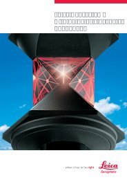
Leica TM30 Monitoring Sensor Every half second ... - GPS partneris
Leica TM30 Monitoring Sensor Every half second ... - GPS partneris
Leica TM30 Monitoring Sensor Every half second ... - GPS partneris

You also want an ePaper? Increase the reach of your titles
YUMPU automatically turns print PDFs into web optimized ePapers that Google loves.
<strong>Leica</strong> <strong>Monitoring</strong><br />
Solutions<br />
<strong>Leica</strong> <strong>TM30</strong><br />
<strong>Monitoring</strong> <strong>Sensor</strong><br />
<strong>Every</strong> <strong>half</strong> <strong>second</strong> counts
<strong>Leica</strong> <strong>TM30</strong><br />
<strong>Monitoring</strong> <strong>Sensor</strong><br />
<strong>Every</strong> <strong>half</strong> <strong>second</strong> counts<br />
We live in a dynamic world. Buildings and dams settle, bridges flex and vibrate, rock<br />
masses shift, mud slides, glaciers flow and volcanoes erupt. Whether by human<br />
activity such as mining and construction or by natural processes such as climate<br />
change and erosion, the world in which we live is continually changing.<br />
Engineering companies and contractors face increased challenges monitoring this change.<br />
They are being charged with – and being held liable for – the condition of the structures<br />
they create and maintain. In order to surmount these challenges, engineers need to be<br />
able to measure structural movements to millimeter-level accuracy.<br />
For equipment to manage and monitor these structures, engineers rely on <strong>Leica</strong> Geosystems<br />
and the <strong>TM30</strong> <strong>Monitoring</strong> sensor: because every <strong>half</strong> <strong>second</strong> counts!<br />
The <strong>Leica</strong> <strong>TM30</strong> combines accurate 0.5" measurements, together with fast data acquisition.<br />
This powerful combination of speed and accuracy allows engineers to effectively and<br />
cost efficiently measure and control the health of vital infrastructure. The <strong>Leica</strong> <strong>TM30</strong>,<br />
designed specifically for use in monitoring applications, incorporates excellent accuracy,<br />
outstanding reliability and robust design from a company with extensive experience in<br />
high precision sensor technology. The combination of SmartEye vision technology and<br />
unique direct drive technology provides faster, more precise and longer range measurements<br />
than ever before.
<strong>Leica</strong> <strong>TM30</strong><br />
Accurate, Fast and Silent<br />
The <strong>Leica</strong> <strong>TM30</strong> is designed to meet the highest accuracy standards. High precision<br />
measurements, combined with automatic, fast and silent operation ensures that<br />
the <strong>TM30</strong> detects the smallest movement in all monitoring applications.<br />
High accuracy angular measurement<br />
The <strong>TM30</strong> offers 0.5" or 1" angular accuracy, ensuring that the highest accuracy standards<br />
are met every time.<br />
SmartEye vision<br />
The <strong>TM30</strong> includes SmartEye vision technology to automatically measure targets up to<br />
3000 m with millimeter accuracy. This advanced technology enables large areas to be<br />
monitored with a single instrument, significantly saving on equipment costs.<br />
Unique high precision PinPoint EDM<br />
Measure targets with higher accuracy than ever before with next generation PinPoint EDM<br />
technology. The <strong>TM30</strong> PinPoint EDM features a unique precision of 0.6 mm + 1ppm to prisms<br />
and 2 mm + 2 ppm to natural surfaces.<br />
Move, Lock, Measure, Transmit<br />
The <strong>TM30</strong> quickly moves with unmatched speed to monitor points. SmartEye vision then<br />
effortlessly locks onto the prism. The long -range PinPoint EDM is seamlessly harmonized<br />
with precise angle sensors to complete the measurement process. Measurement data is<br />
then immediately available for on-board storage, or to be transmitted to any location via<br />
cable, radio, mobile phone or the internet. The optimized high accuracy measurement<br />
process of the <strong>TM30</strong> ensures maximum productivity and efficiency.<br />
Zero noise pollution<br />
The <strong>TM30</strong> is equipped with direct drives based on piezo technology which are not only<br />
extremely fast but very quiet. The <strong>TM30</strong> can be installed in urban areas with confidence due<br />
to zero noise pollution.
<strong>Leica</strong> <strong>TM30</strong><br />
Robust and Reliable<br />
Critical man-made structures and natural phenomenon need to be measured continuously.<br />
The <strong>Leica</strong> <strong>TM30</strong> will operate 24 hours a day, 365 days a year, and continue to deliver top<br />
quality measurements. The <strong>TM30</strong> is built to be tough and to be left unattended in remote,<br />
hostile environments. The <strong>Leica</strong> <strong>TM30</strong> distinguishes itself with robustness, reliability,<br />
minimal maintenance and lowest power consumption.<br />
Continuous operation<br />
The <strong>TM30</strong> meets the challenge of 24 hours, 7 days a week monitoring applications.<br />
It is designed to withstand the roughest use in the most severe environments.<br />
The <strong>TM30</strong> will operate throughout a wide temperature range and is<br />
protected against wind driven rain, sand and dust. The sensor is fully operational<br />
in bright sunlight and complete darkness.<br />
Long service intervals<br />
The <strong>TM30</strong> can operate for extremely long intervals without suffering from wear<br />
and tear. The long service interval, low maintenance costs and continuous<br />
operation ensure maximum productivity.<br />
Theft protection and keyboard lock<br />
A PIN-code feature and keyboard lock prevent unauthorized persons from<br />
using the instrument. Without a correct code, the equipment can’t be<br />
operated or data erased. This increases your data security and makes it<br />
unattractive to steal.<br />
Lowest Power Consumption<br />
The <strong>Leica</strong> <strong>TM30</strong> unique piezo direct drive technology ensures maximum<br />
accuracy whilst minimizing power consumption with intelligent<br />
on-demand power management.
<strong>Leica</strong> <strong>TM30</strong><br />
SmartEye Vision<br />
<strong>Leica</strong> SmartEye vision is the combination of long range Automatic Target<br />
Recognition (ATR), TargetView and TargetCapture technology. The <strong>TM30</strong> is<br />
the only sensor combining long range with exceptionally high accuracy to<br />
meet the demands of any monitoring application.<br />
Long range ATR<br />
The long range ATR detects and measures to prisms within a range of<br />
up to 3000 m with millimeter accuracy. Long range ATR maximizes the<br />
flexibility of instrument placement. Instrument damage can be avoided<br />
and security ensured, reducing overall costs in a large monitoring project.<br />
TargetView<br />
The TargetView functionality narrows the field of view of the ATR to the<br />
area of interest. If there are multiple prisms close together the measurement<br />
process is enhanced by detecting the correct prisms without interference<br />
from surrounding prisms.<br />
TargetCapture<br />
TargetCapture makes the telescopic camera image available for visual<br />
documentation of the point measured. Obstructions in the line of sight<br />
can be inspected remotely, avoiding safety concerns in high-risk environments.
<strong>Leica</strong> <strong>TM30</strong><br />
Decades of experience<br />
in precision monitoring<br />
<strong>Leica</strong> Geosystems has unrivalled experience in precise monitoring with instruments operating<br />
around the world for decades. Building on this experience, the <strong>Leica</strong> <strong>TM30</strong> is the latest generation<br />
of total stations designed specifically for precise monitoring. Offering full backward compatibility,<br />
the <strong>Leica</strong> <strong>TM30</strong> can be installed in any new or existing monitoring project.<br />
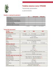
<strong>Leica</strong> <strong>TM30</strong> Performance Specifications<br />
Angle Measurement<br />
Accuracy 1)<br />
0.5" (0.15 mgon), 1" (0.3 mgon)<br />
Method<br />
Absolute, continuous, quadruple<br />
Distance Measurement (Prism)<br />
Range Round Prism (GPR1) 3500 m<br />
Accuracy 2) / Measurement time Precise 3,4) 0.6 mm + 1 ppm / typ. 7s<br />
Standard<br />
1 mm + 1 ppm / typ. 2.4 s<br />
Method<br />
System analyzer based on phase shift measurement (coaxial, visible red laser)<br />
Distance Measurement (Non-Prism)<br />
Range 5)<br />
1000 m<br />
Accuracy 2,6) / Measurement time<br />
2 mm + 2 ppm / typ. 3 s<br />
Method<br />
System analyzer based on phase shift measurement (coaxial, visible red laser)<br />
Motorization<br />
Maximum acceleration 400 gon (360°)/ s 2<br />
Rotation Speed<br />
200 gon (180°)/ s<br />
Time for change face<br />
2.9 s<br />
Positioning Time for 200 gon (180°) 2.3 s<br />
Method<br />
Direct drives based on Piezo technology<br />
Automatic Target Recognition (ATR)<br />
Range 3) Round prism (GPR1) 3000 m<br />
Accuracy 1) / Measurement time (GPR1) ATR angle accuracy Hz, V 1"/ 3 - 4 s<br />
Base positioning accuracy<br />
± 1 mm<br />
Pointing precision at 3000 m<br />
± 7 mm<br />
Minimum spacing between prism at 200 m 0.3 m<br />
Method<br />
Digital Image processing<br />
General<br />
Telescope Magnification / Focusing Range 30 x / 1.7 m to infinity<br />
Keyboard and Display<br />
¼ VGA, colour, touch, 34 keys, illuminated<br />
Data storage<br />
256 MB Internal memory, Compact Flash cards 256 MB or 1 GB<br />
Interfaces<br />
RS232, Bluetooth ® Wireless<br />
Operation<br />
Three endless drives for one or two hand manual operation<br />
Userdefinable Smart key for manual fast high precision measurements<br />
Laser plummet<br />
Standby Power Consumption<br />
typ. 5.9 W<br />
Security<br />
Password protection and keyboard lock<br />
Operating temperature –20° C to + 50° C (–4° F to + 122° F)<br />
Dust / water (IEC 60529)<br />
IP54<br />
Humidity<br />
95%, non-condensing<br />
1)<br />
Standard Deviation ISO-17123-3<br />
2)<br />
Standard Deviation ISO-17123-4<br />
3)<br />
Overcast, no haze, visibility about 40 km, no heat shimmer<br />
4)<br />
range up to 1000 m, GPH1P reflector<br />
5)<br />
Object in shade, sky overcast, Kodak Gray Card (90% reflective)<br />
6)<br />
Distance > 500 m 4 mm + 2 ppm
<strong>Leica</strong> <strong>TM30</strong><br />
Complete<br />
<strong>Monitoring</strong> Integration<br />
<strong>Leica</strong> <strong>Monitoring</strong><br />
Solutions<br />
The <strong>Leica</strong> <strong>TM30</strong> forms one component of a unique <strong>Monitoring</strong> solution<br />
which seamlessly integrates total stations, GNSS receivers and antennas,<br />
geotechnical sensors, software and IT communication infrastructures.<br />
<strong>Leica</strong> GeoMoS software provides a highly flexible automatic deformation<br />
monitoring system that is able to combine geodetic, geotechnical and<br />
meteorological sensors to match the needs of your monitoring project,<br />
whether it is large or small, temporary or permanent.<br />
<strong>Leica</strong> GeoMoS Web is a web based service for the visualization and<br />
analysis of monitoring data collected by a GeoMoS monitoring system.<br />
Access your monitoring project anywhere, anytime using your web<br />
browser, pocket pc or mobile phone.<br />
GMX<br />
902GG<br />
NIVEL<br />
210<br />
NIVEL<br />
220<br />
GMX<br />
901 <strong>TM30</strong><br />
GMX<br />
<strong>Leica</strong><br />
GeoMoS<br />
<strong>Leica</strong><br />
GeoMoS<br />
Web
Whether you monitor the movement of a volcanic slope, the structure<br />
of a long bridge or track the settlement of a dam; whether you measure,<br />
analyse and manage the structures of natural or man-made objects:<br />
the monitoring systems by <strong>Leica</strong> Geosystems provide you with the right<br />
solution for every application.<br />
Our solutions provide reliable, precise data acquisition, advanced<br />
processing, sophisticated analysis and secure data transmission. Using<br />
standard interfaces, open architectures and scalable platforms, the<br />
solutions are customizable to meet individual requirements – for<br />
permanent and temporary installations, for single sites and monitoring<br />
networks.<br />
When it has to be right.<br />
Illustrations, descriptions and technical data are not binding. All rights reserved.<br />
Printed in Switzerland – Copyright <strong>Leica</strong> Geosystems AG, Heerbrugg, Switzerland, 2009.<br />
772009en – II.09 – RDV<br />
Total Quality Management –<br />
our commitment to total<br />
customer satisfaction.<br />
Ask your local <strong>Leica</strong> Geosystems<br />
dealer for more information<br />
about our TQM program.<br />
Distance meter (Prism), ATR:<br />
Laser class 1 in accordance<br />
with IEC 60825-1 resp. EN<br />
60825-1<br />
Laser plummet:<br />
Laser class 2 in accordance<br />
with IEC 60825-1 resp. EN<br />
60825-1<br />
<strong>Leica</strong> TS30<br />
<strong>Leica</strong> <strong>Monitoring</strong><br />
Solutions<br />
Software<br />
<strong>Leica</strong> GeoMoS<br />
<strong>Leica</strong> GNSS Spider<br />
<strong>Leica</strong> GNSS QC<br />
<strong>Leica</strong> GeoMoS Web<br />
<strong>GPS</strong>/GNSS<br />
<strong>Leica</strong> GMX902 GG<br />
<strong>Leica</strong> GRX1200 Series<br />
<strong>Leica</strong> <strong>GPS</strong>1200 Series<br />
<strong>Leica</strong> GMX901<br />
Other<br />
<strong>Leica</strong> Nivel210/220<br />
<strong>Leica</strong> GPR112<br />
<strong>Monitoring</strong> Prism<br />
Distance meter (Non-Prism):<br />
Laser class 3R in accordance<br />
with IEC 60825-1 resp. EN<br />
60825-1<br />
The Bluetooth® word mark and<br />
logos are owned by Bluetooth<br />
SIG, Inc. and any use of such<br />
marks by <strong>Leica</strong> Geosystems AG is<br />
under license. Other trademarks<br />
and trade names are those of<br />
their respective owners.<br />
<strong>Leica</strong> Geosystems AG<br />
Heerbrugg, Switzerland<br />
www.leica-geosystems.com