Leica SmartStation Total Station with integrated GPS - Geotech
Leica SmartStation Total Station with integrated GPS - Geotech
Leica SmartStation Total Station with integrated GPS - Geotech
You also want an ePaper? Increase the reach of your titles
YUMPU automatically turns print PDFs into web optimized ePapers that Google loves.
<strong>Leica</strong> <strong>Smart<strong>Station</strong></strong><br />
<strong>Total</strong> <strong>Station</strong><br />
<strong>with</strong> <strong>integrated</strong> <strong>GPS</strong>
<strong>Leica</strong> <strong>Smart<strong>Station</strong></strong><br />
<strong>Total</strong> station <strong>with</strong><br />
<strong>integrated</strong> <strong>GPS</strong><br />
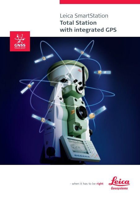
New revolutionary surveying system.<br />
World’s first, TPS and <strong>GPS</strong> perfectly<br />
combined. High performance<br />
total station <strong>with</strong> powerful GNSS receiver.<br />
No need for control points,<br />
long traverses or resections.<br />
Just set up <strong>Smart<strong>Station</strong></strong> and let<br />
<strong>GPS</strong> determine the position.<br />
Then measure and stake out<br />
<strong>with</strong> the total station.<br />
You survey easier, quicker<br />
and <strong>with</strong> fewer set ups.<br />
Use TPS and <strong>GPS</strong> separately<br />
when required.<br />
Put the SmartAntenna on a<br />
pole as an RTK rover.<br />
Use the TPS as a standard<br />
total station.<br />
<strong>Smart<strong>Station</strong></strong>’s modular design<br />
gives you all the options.<br />
Undertake any type of job.<br />
Save time and money.<br />
Increase your productivity<br />
and profits.<br />
All TPS1200 total stations can<br />
be upgraded to <strong>Smart<strong>Station</strong></strong>.
Incredibly versatile<br />
Use it in any way you like<br />
<strong>Smart<strong>Station</strong></strong> position coordinates<br />
at the touch of a key<br />
With <strong>Smart<strong>Station</strong></strong> you don’t need to worry about control<br />
points, traverses and resections. Just set up wherever it’s<br />
convenient, touch the <strong>GPS</strong> key and let the SmartAntenna<br />
do the rest. RTK determines the position to centimeter<br />
accuracy <strong>with</strong>in a few seconds at ranges up to 50 km from<br />
a reference station. With <strong>Smart<strong>Station</strong></strong> you’re ready to go<br />
in the shortest possible time; fix the position <strong>with</strong> <strong>GPS</strong> and<br />
then survey <strong>with</strong> the total station.<br />
<strong>GPS</strong> fully <strong>integrated</strong> into total station<br />
With the entire software in the total station, all TPS and <strong>GPS</strong><br />
operations are controlled via the TPS keyboard. All data are<br />
stored in the same database on the same CompactFlash card.<br />
All measurement, status and other information are displayed<br />
on the TPS screen. The TPS plug-in battery also powers<br />
the <strong>GPS</strong> SmartAntenna and RTK communication device.<br />
All components combine perfectly. Everything is <strong>integrated</strong><br />
into one compact unit – no need for cables, external battery,<br />
data logger etc.<br />
Use as <strong>Smart<strong>Station</strong></strong>, or as a total station<br />
and RTK rover<br />
With <strong>Smart<strong>Station</strong></strong>’s modular design, you can use the<br />
equipment in any way you like. Use <strong>Smart<strong>Station</strong></strong> when<br />
there are no control points available. Once <strong>Smart<strong>Station</strong></strong> is<br />
accurately positioned, take off the SmartAntenna, put it on<br />
a pole, and use it <strong>with</strong> the RX1250 Controller for as a fully<br />
fleged, ultra light SmartRover. You’re totally flexible <strong>with</strong><br />
<strong>Smart<strong>Station</strong></strong>.
<strong>Leica</strong> <strong>Smart<strong>Station</strong></strong><br />
A new way to survey<br />
Remote Area<br />
Topographic Survey<br />
Rural Area<br />
Boundary Survey<br />
Time required for setup<br />
Conventional 100%<br />
<strong>Smart<strong>Station</strong></strong> 50%<br />
Time required for setup<br />
Conventional 100%<br />
<strong>Smart<strong>Station</strong></strong> 20%<br />
Situation<br />
Survey company has a<br />
detail and topographic<br />
survey in a remote area.<br />
Vegetation makes kinematic<br />
RTK difficult and a<br />
total station has to be<br />
used. There are no control<br />
points but there is a<br />
reference station 40 km<br />
away transmitting RTK.<br />
The conventional way<br />
Fix a series of control<br />
points <strong>with</strong> <strong>GPS</strong>. Transfer<br />
the coordinates into the<br />
total station. Occupy<br />
the points <strong>with</strong> the total<br />
station, orient to other<br />
points, and survey the<br />
detail. If the total station<br />
occupies points before<br />
<strong>GPS</strong>, results have to be<br />
transformed in the office.<br />
Points have to be occupied<br />
twice, once <strong>with</strong> <strong>GPS</strong> and<br />
once <strong>with</strong> the total station.<br />
Two sets of equipment<br />
are needed. Two crews<br />
may be needed. It may<br />
be necessary to transform<br />
results.<br />
The <strong>Smart<strong>Station</strong></strong> way<br />
Set up <strong>Smart<strong>Station</strong></strong><br />
where it is convenient and<br />
determine the position<br />
<strong>with</strong> RTK. Orient to a<br />
second point that will be<br />
used but is not coordinated<br />
yet. Survey the detail from<br />
the first station.<br />
Set up at the second point<br />
and determine the position<br />
<strong>with</strong> RTK. As the bearing<br />
between the points is<br />
now known, <strong>Smart<strong>Station</strong></strong><br />
transforms the coordinates<br />
of all detail surveyed from<br />
the first point. Orient to<br />
the first point and survey<br />
the detail from the second<br />
point.<br />
The advantages<br />
Points occupied<br />
only once.<br />
Only <strong>Smart<strong>Station</strong></strong><br />
is needed.<br />
Only one crew<br />
is needed.<br />
Automatic<br />
transformations.<br />
The survey takes<br />
less time.<br />
Situation<br />
A farm boundary has to be<br />
surveyed <strong>with</strong> a total station.<br />
The nearest control<br />
points are 5 km away. RTK<br />
data can be received from<br />
a reference station.<br />
The conventional way<br />
Bring in control by measuring<br />
a long traverse from<br />
the control points.<br />
Traverse close to the<br />
boundary and coordinate<br />
the boundary markers<br />
from the traverse stations.<br />
An open traverse is liable<br />
to error. A closed traverse<br />
will take twice as long.<br />
Even <strong>with</strong> careful planning,<br />
traversing in difficult terrain<br />
is complicated and<br />
time consuming.<br />
The <strong>Smart<strong>Station</strong></strong> way<br />
Set up <strong>Smart<strong>Station</strong></strong> at a<br />
first point where one or<br />
more boundary markers<br />
can be seen. Fix the position<br />
<strong>with</strong> RTK. Orient to<br />
a second point, which is<br />
not yet fixed. Measure<br />
angles and distances to<br />
the markers.<br />
Set up at the second<br />
point, fix the position and<br />
orient to the first point.<br />
All previous measurements<br />
are transformed automatically<br />
in <strong>Smart<strong>Station</strong></strong>.<br />
Survey the markers from<br />
the second point.<br />
Survey the boundary in<br />
this way using pairs or<br />
clusters of <strong>Smart<strong>Station</strong></strong><br />
points.<br />
The advantages<br />
No long traverses<br />
needed.<br />
Less set ups needed.<br />
Fewer people required.<br />
Takes less time.<br />
Uniform,<br />
higher accuracy.
Construction site<br />
Stakeout<br />
Urban Area<br />
Utilities Survey<br />
Time required for setup<br />
Time required for setup<br />
Conventional 100%<br />
Conventional 100%<br />
<strong>Smart<strong>Station</strong></strong> 40%<br />
<strong>Smart<strong>Station</strong></strong> 40%<br />
Situation<br />
A large number of markers<br />
have to be placed and<br />
many components<br />
positioned. Control<br />
points exist but often get<br />
damaged or are covered<br />
by equipment, material,<br />
vehicles etc. There is a<br />
<strong>GPS</strong> reference station but,<br />
due to obstructions and<br />
the type of construction,<br />
most points cannot be set<br />
out <strong>with</strong> RTK.<br />
The conventional way<br />
Stakeout <strong>with</strong> a total station<br />
is possible but difficult and<br />
time consuming.Traversing<br />
is needed to get around<br />
obstructions. Temporary<br />
points, which can be<br />
used for stakeout, have to<br />
be established. The work<br />
plan has to be revised<br />
constantly. Equipment and<br />
material have to be moved,<br />
which slows down both the<br />
survey and construction<br />
work.<br />
The <strong>Smart<strong>Station</strong></strong> way<br />
Control points are not<br />
required. Simply set up<br />
<strong>Smart<strong>Station</strong></strong> wherever<br />
it’s convenient.<br />
Set up at a first point and<br />
fix the position <strong>with</strong> RTK.<br />
Set up at a second point,<br />
fix the position, use the<br />
first point for orientation,<br />
and stake out from the<br />
second point.<br />
Work in this way<br />
establishing pairs or<br />
groups of points from<br />
which to stake out. As RTK<br />
determines the positions,<br />
the groups do not have<br />
to be connected by total<br />
station measurements.<br />
The advantages<br />
Set up where<br />
convenient.<br />
No traversing needed.<br />
Fewer obstructions.<br />
Faster stakeout.<br />
Faster construction<br />
work.<br />
Situation<br />
The positions of all<br />
manholes, covers, hydrants,<br />
distribution boxes etc. for<br />
water, gas and electricity<br />
have to be determined.<br />
High buildings and trees<br />
along the roads prevent<br />
the use of RTK rover<br />
equipment. Many objects<br />
are close to buildings or<br />
under trees. The city<br />
operates <strong>GPS</strong> reference<br />
stations.<br />
The conventional way<br />
Control points exist but<br />
traffic, parked vehicles and<br />
other obstructions make it<br />
difficult to set up over<br />
them and orient between<br />
them. If a standard total<br />
station is used, a lot of<br />
traversing in a very difficult<br />
environment will be<br />
necessary. Both careful<br />
planning and improvisation<br />
will be needed. The work<br />
will be awkward and slow.<br />
The <strong>Smart<strong>Station</strong></strong> way<br />
Set up <strong>Smart<strong>Station</strong></strong> where<br />
RTK fixes are possible, such<br />
as at road intersections,<br />
open spaces and even<br />
on the tops of buildings.<br />
Use pairs of <strong>Smart<strong>Station</strong></strong><br />
setups as explained in<br />
the previous examples.<br />
Measure angles and<br />
distances to the objects<br />
that have to be surveyed.<br />
The advantages<br />
Control points<br />
not needed.<br />
No awkward traversing.<br />
RTK fixes the positions.<br />
Consistent high<br />
accuracy.<br />
Fast, flexible, convenient.<br />
Much easier, saves time.
<strong>Leica</strong> System 1200 –<br />
<strong>Smart<strong>Station</strong></strong> and<br />
SmartAntenna<br />
High accuracy <strong>GPS</strong><br />
positioning<br />
<strong>Leica</strong>’s SmartCheck<br />
algorithms compute static<br />
RTK fixes <strong>with</strong> 10 mm + 1<br />
ppm horizontal and 20 mm<br />
+ 1 ppm vertical accuracy<br />
at ranges up to 50 km.<br />
Reliability is 99.99%.<br />
ATX1230/ATX1230GG<br />
SmartAntenna<br />
72 Channel receiver incorporating<br />
<strong>Leica</strong>’s SmartTrack<br />
GNSS technology. Strong<br />
signals, fast satellite acquisition,<br />
<strong>GPS</strong> and GLONASS<br />
tracking to low elevations,<br />
multipath mitigation and<br />
anti-jamming guarantee<br />
top performance.<br />
<strong>integrated</strong><br />
With Bluetooth ® wireless<br />
technology built into the<br />
total station, you can<br />
transfer data wirelessly to<br />
PDA’s and cell phones.<br />
The Bluetooth ® device<br />
in the SmartAntenna<br />
facilitates connectivity<br />
when the SmartAntenna<br />
is used as a stand-alone<br />
rover.<br />
CompactFlash card<br />
<strong>Smart<strong>Station</strong></strong>, TPS and<br />
<strong>GPS</strong> data are stored in<br />
the same job, in the<br />
same database, on the<br />
same CompactFlash card.<br />
Plug-in Li-Ion battery<br />
One small plug-in battery<br />
provides long-lasting<br />
power for <strong>Smart<strong>Station</strong></strong>.<br />
Cables and external<br />
batteries are<br />
not required.<br />
Operated via<br />
TPS keyboard<br />
With <strong>Smart<strong>Station</strong></strong>,<br />
the TPS keyboard controls<br />
all measurements, operations<br />
and routines for<br />
both TPS and <strong>GPS</strong>.<br />
FUNCTION<br />
<strong>integrated</strong><br />
<strong>Smart<strong>Station</strong></strong> combines TPS and <strong>GPS</strong> in one instrument.<br />
Use TPS and <strong>GPS</strong> together or separately, according to the work you do.<br />
Survey faster, more accurately and more efficiently.<br />
Enjoy all the freedom, flexibility and power of System 1200.<br />
<strong>Leica</strong> <strong>Smart<strong>Station</strong></strong><br />
<strong>Leica</strong> <strong>GPS</strong>1200<br />
TPS1200 <strong>with</strong> <strong>integrated</strong><br />
<strong>GPS</strong>. All TPS1200 can be<br />
upgraded to <strong>Smart<strong>Station</strong></strong>.<br />
Unites top <strong>GPS</strong> technology<br />
<strong>with</strong> powerful data<br />
management. Perfect for<br />
all <strong>GPS</strong> applications.
ATX1230(GG)<br />
SmartAntenna<br />
as stand-alone rover<br />
When not on <strong>Smart<strong>Station</strong></strong>,<br />
the SmartAntenna can be<br />
used <strong>with</strong> the RX1250 as<br />
an ultra light, fully fledged<br />
SmartRover. Use it on a<br />
pole as an RTK rover or on<br />
a tripod for logging data<br />
and post processing, <strong>with</strong><br />
all the capabilities and<br />
performance of <strong>GPS</strong>1200.<br />
<strong>GPS</strong> reference stations<br />
Connect to a reference<br />
station and let <strong>Smart<strong>Station</strong></strong><br />
fix its position. Static RTK<br />
provides high accuracy<br />
in accordance <strong>with</strong> the<br />
accuracy specifications<br />
provided by the reference<br />
station network.<br />
GRX1200 Lite and<br />
<strong>GPS</strong> Spider software<br />
If public reference stations<br />
are not conveniently<br />
available, set up your own<br />
private reference station<br />
using the GRX1200 Lite<br />
receiver and <strong>GPS</strong> Spider<br />
software.<br />
RTK communication<br />
devices<br />
There is a wide choice of<br />
communication devices<br />
<strong>with</strong> <strong>Smart<strong>Station</strong></strong>. Radio<br />
modems, GSM, GPRS and<br />
CDMA modules fit neatly<br />
into a small, waterproof,<br />
clip-on housing.<br />
<strong>Leica</strong> TPS1200<br />
<strong>Leica</strong> SmartPole<br />
<strong>Leica</strong> SmartWorx<br />
<strong>Leica</strong> Geo Office<br />
Top performance, high<br />
accuracy total stations<br />
do everything you want<br />
and much more.<br />
Save time <strong>with</strong> SmartPoles’<br />
setup On-the-fly and<br />
easily swap between <strong>GPS</strong><br />
and TPS when needed.<br />
SmartWorx TPS/<strong>GPS</strong><br />
application software is<br />
both easy-to-use and<br />
extremely powerful.<br />
Everything you need in a<br />
single package for TPS and<br />
<strong>GPS</strong>: import, visualization,<br />
conversions, quality control,<br />
processing, adjustment,<br />
reporting, export etc.
Whether you want to survey a parcel of land or a construction site, a<br />
facade or indoors to create as-built plans or carry out high-precision<br />
measurements of bridge and tunnel constructions – <strong>Leica</strong> Geosystems’<br />
surveying instruments provide the right solution for all measuring tasks.<br />
The System 1200 Series instruments as well as the software are designed<br />
to meet the daily challenges of modern surveying. They all have<br />
outstanding, easy to read and user-friendly interfaces. Their straightforward<br />
menu structures, their clearly outlined scope of functions and<br />
high technology perfectly mate <strong>GPS</strong> and TPS applications in the field.<br />
Whether you use the advantages of both technologies combined or each<br />
separately – due to the exceptional flexibility of <strong>Leica</strong> Geosystems<br />
instruments, reliable and productive surveying is assured.<br />
When it has to be right.<br />
Illustrations, descriptions and technical specifications are not binding and may change.<br />
Printed in Switzerland – Copyright <strong>Leica</strong> Geosystems AG, Heerbrugg, Switzerland, 2006.<br />
743121en – XI.06 – RDV<br />
<strong>Total</strong> Quality Management –<br />
our commitment to total<br />
customer satisfaction.<br />
Ask your local <strong>Leica</strong> Geosystems<br />
dealer for more information<br />
about our TQM program.<br />
Distance meter<br />
(PinPoint R100 / R300):<br />
Laser class 3R in accordance<br />
<strong>with</strong> IEC 60825-1 resp. EN 60825-1<br />
Laser plummet:<br />
Laser class 2 in accordance<br />
<strong>with</strong> IEC 60825-1 resp. EN 60825-1<br />
Lorem <strong>Leica</strong> ipsumSmartPole<br />
dolor sit. Product brochure<br />
Adipisicing elit,<br />
sed do eiusmod<br />
tempor incididunt<br />
ut labore et.<br />
<strong>Leica</strong> <strong>GPS</strong>1200<br />
Product brochure<br />
<strong>Leica</strong> TPS1200<br />
Product brochure<br />
<strong>Leica</strong> System 1200<br />
Software<br />
Product brochure<br />
<strong>Leica</strong> GRX1200<br />
Product brochure<br />
Distance meter (IR),<br />
ATR and PowerSearch:<br />
Laser class 1 in accordance<br />
<strong>with</strong> IEC 60825-1 resp. EN 60825-1<br />
Guide light (EGL):<br />
LED class 1 in accordance<br />
<strong>with</strong> IEC 60825-1 resp. EN 60825-1<br />
The Bluetooth ® word mark and logos<br />
are owned by Bluetooth SIG, Inc. and<br />
any use of such marks by <strong>Leica</strong><br />
Geosystems AG is under license. Other<br />
trademarks and trade names are<br />
those of their respective owners.<br />
<strong>Leica</strong> Geosystems AG<br />
Switzerland<br />
www.leica-geosystems.com


