

Review of Greenland Avtivities 2001 - Aeromagnetic survey ... - Geus
Review of Greenland Avtivities 2001 - Aeromagnetic survey ... - Geus
Review of Greenland Avtivities 2001 - Aeromagnetic survey ... - Geus

Create successful ePaper yourself
Turn your PDF publications into a flip-book with our unique Google optimized e-Paper software.
56° 54° 52°<br />
72°<br />
72°<br />
71°30′<br />
71°<br />
70°30′<br />
50 km<br />
71°30′<br />
71°<br />
nT<br />
608<br />
364<br />
233<br />
150<br />
78<br />
35<br />
6<br />
– 13<br />
– 29<br />
– 43<br />
– 55<br />
– 66<br />
– 75<br />
– 84<br />
– 92<br />
– 100<br />
– 108<br />
– 117<br />
– 124<br />
– 131<br />
– 138<br />
– 145<br />
– 151<br />
– 159<br />
– 166<br />
– 175<br />
– 184<br />
– 194<br />
– 206<br />
– 222<br />
– 242<br />
– 271<br />
– 325<br />
– 387<br />
– 460<br />
– 546<br />
– 653<br />
– 815<br />
56° 54° 52°<br />
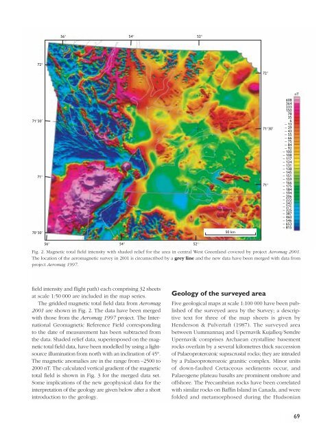
Fig. 2. Magnetic total field intensity with shaded relief for the area in central West <strong>Greenland</strong> covered by project Aeromag <strong>2001</strong>.<br />
The location <strong>of</strong> the aeromagnetic <strong>survey</strong> in <strong>2001</strong> is circumscribed by a grey line and the new data have been merged with data from<br />
project Aeromag 1997.<br />
field intensity and flight path) each comprising 32 sheets<br />
at scale 1:50 000 are included in the map series.<br />
The gridded magnetic total field data from Aeromag<br />
<strong>2001</strong> are shown in Fig. 2. The data have been merged<br />
with those from the Aeromag 1997 project. The International<br />
Geomagnetic Reference Field corresponding<br />
to the date <strong>of</strong> measurement has been subtracted from<br />
the data. Shaded relief data, superimposed on the magnetic<br />
total field data, have been modelled by using a lightsource<br />
illumination from north with an inclination <strong>of</strong> 45°.<br />
The magnetic anomalies are in the range from –2500 to<br />
2000 nT. The calculated vertical gradient <strong>of</strong> the magnetic<br />
total field is shown in Fig. 3 for the merged data set.<br />
Some implications <strong>of</strong> the new geophysical data for the<br />
interpretation <strong>of</strong> the geology are given below after a short<br />
introduction to the geology.<br />
Geology <strong>of</strong> the <strong>survey</strong>ed area<br />
Five geological maps at scale 1:100 000 have been published<br />
<strong>of</strong> the <strong>survey</strong>ed area by the Survey; a descriptive<br />
text for three <strong>of</strong> the map sheets is given by<br />
Henderson & Pulvertaft (1987). The <strong>survey</strong>ed area<br />
between Uummannaq and Upernavik Kujalleq/Søndre<br />
Upernavik comprises Archaean crystalline basement<br />
rocks overlain by a several kilometres thick succession<br />
<strong>of</strong> Palaeoproterozoic supracrustal rocks; they are intruded<br />
by a Palaeoproterozoic granitic complex. Minor units<br />
<strong>of</strong> down-faulted Cretaceous sediments occur, and<br />
Palaeogene plateau basalts are prominent onshore and<br />
<strong>of</strong>fshore. The Precambrian rocks have been correlated<br />
with similar rocks on Baffin Island in Canada, and were<br />
folded and metamorphosed during the Hudsonian<br />
69


