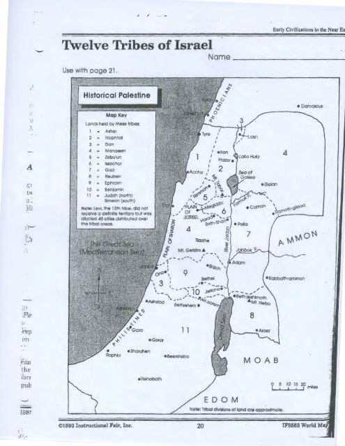
Map: 12 Tribes of Israel
Map: 12 Tribes of Israel
Map: 12 Tribes of Israel

Create successful ePaper yourself
Turn your PDF publications into a flip-book with our unique Google optimized e-Paper software.
-<br />
Twelve <strong>Tribes</strong> <strong>of</strong> <strong>Israel</strong><br />
Use with page 21.<br />
Early Civi1izations in the Near<br />
Name -------------1<br />
• Damascus<br />
')1<br />
. ~ .<br />
A<br />
Lands held by these trlbes:<br />
1 "' Asher<br />
2 Naphtall<br />
3 Don<br />
4<br />
5 :;<br />
Monosseh<br />
Zebuiun<br />
6 lssachar<br />
7 God<br />
8 Reuben<br />
9 Ephraim<br />
10 Benjamin<br />
11 Judah (north)<br />
Simeon (south)<br />
Note: levi, the <strong>12</strong>th tribe, did not<br />
receive a detlnlle territory but was<br />
allotted 48 cities distributed over<br />
the tribal areas.<br />
ecamon<br />
•Golan<br />
4<br />
7<br />
;t<br />
,. I<br />
.~~ ]<br />
:Pe<br />
on<br />
•Geror<br />
1 1<br />
;; ~ · · .. ,<br />
. ~:ozr<br />
the<br />
,. ,,<br />
.torr<br />
pub<br />
•Sharuhen<br />
•Rehoboth<br />
•Beersheba<br />
M 0 A B<br />
J.SBr<br />
Note: Tribal divisions ot land are approximate.<br />
.... ·<br />
©1992 Instructional Fair, Inc.<br />
20 IF8553 World
'1\velve <strong>Tribes</strong> <strong>of</strong> <strong>Israel</strong> (Continued)<br />
use the map on page 20 to answer the questions below.<br />
Early Civilizations in the Near East<br />
Name-------------<br />
·:...' .. !''<br />
0;: l . Palestine's western boundary was formed by the ____________ Sea, also<br />
called the<br />
Sea.<br />
2. The tribal land east <strong>of</strong> the Dead Sea was controlled by the ________ trlbe.<br />
3. Wh ich tribe was scattered among 48 cities?----------------<br />
4. lyre and Accho were in an area controlled by the ----------- tribe.<br />
5. The Plain <strong>of</strong> Sharon was on the --------- coast <strong>of</strong> Palestine.<br />
6. Jericho and Jerusalem were on land occupied by the tribe <strong>of</strong> _________ _<br />
7. Name the river which flowed between the Dead Sea and the Sea <strong>of</strong> Galilee.<br />
8. The city <strong>of</strong> ___________ __.. was southwest <strong>of</strong> Lake Hula.<br />
9. Which two tribes each occupied two separate areas <strong>of</strong> land? _________ _<br />
I<br />
'I<br />
I 0. Mt. Nebo was in the area controlled by the tribe <strong>of</strong>------------<br />
~- 11. Sidon was a city on land held by the ------------<br />
<strong>12</strong>. Mt. Gerizim was south <strong>of</strong> the city <strong>of</strong> ------------<br />
13. Other than the Jordan, what two rivers are shown on the map? ___ , _____ _<br />
· ... . •'<br />
' 4. The city <strong>of</strong> Joppa was on the banks <strong>of</strong> the ------------ Sea.<br />
15. Laish was located on land held by the tribe <strong>of</strong> ---------<br />
l 6. Use a ruler to measure the approximate distance between these cities.<br />
A. Rehoboth to Ono F. Hazar to Jericho<br />
B. Damascus to Laish G. Beersheba to Bethlehem<br />
C. Gaza to Joppa H. Aroer to Rimmon<br />
D. Jericho to Golan I. Dor to Adam<br />
E. Shiloh to Beth-Shan J. Ashdod to Tyre<br />
i<br />
'i<br />
:. ·<br />
'·i<br />
'I<br />
i.<br />
· ©1992 Instructional Fair, Inc. 21 IF8553 World <strong>Map</strong> Skills<br />
''-------·