Boulevard Corridor Redevelopment Plan - College of Humanities ...
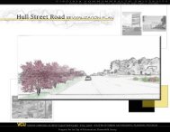
Boulevard Corridor Redevelopment Plan - College of Humanities ...
Boulevard Corridor Redevelopment Plan - College of Humanities ...

Create successful ePaper yourself
Turn your PDF publications into a flip-book with our unique Google optimized e-Paper software.
<strong>Boulevard</strong><br />
<strong>Corridor</strong><br />
<strong>Redevelopment</strong><br />
<strong>Plan</strong><br />
Yawandale Birchett-Thompson<br />
URSP 762 Studio II, Spring 2008<br />
Virginia Commonwealth University<br />
Richmond, Virginia
Table <strong>of</strong> Contents<br />
Introduction . . . . . . . . . . . . . . . . . . . . . . . . . . . . . . . . . . . . . . . . . . . . . . . . . . . . . . . 4<br />
Existing Conditions . . . . . . . . . . . . . . . . . . . . . . . . . . . . . . . . . . . . . . . . . . . . . . . . . 5<br />
History. . . . . . . . . . . . . . . . . . . . . . . . . . . . . . . . . . . . . . . . . . . . . . . . . . . . . . . 6<br />
Population. . . . . . . . . . . . . . . . . . . . . . . . . . . . . . . . . . . . . . . . . . . . . . . . . . . . . 8<br />
Current Land Use . . . . . . . . . . . . . . . . . . . . . . . . . . . . . . . . . . . . . . . . . . . . . . .10<br />
Zoning . . . . . . . . . . . . . . . . . . . . . . . . . . . . . . . . . . . . . . . . . . . . . . . . . . . . . .17<br />
Circulation . . . . . . . . . . . . . . . . . . . . . . . . . . . . . . . . . . . . . . . . . . . . . . . . . . . .19<br />
Crime and Safety . . . . . . . . . . . . . . . . . . . . . . . . . . . . . . . . . . . . . . . . . . . . . . . 22<br />
Surrounding Influences. . . . . . . . . . . . . . . . . . . . . . . . . . . . . . . . . . . . . . . . . . . .24<br />
Strengths, Weaknesses, Threats and Opportunities. . . . . . . . . . . . . . . . . . . . . . . . . 26<br />
The <strong>Plan</strong>. . . . . . . . . . . . . . . . . . . . . . . . . . . . . . . . . . . . . . . . . . . . . . . . . . . . . . . . . .29<br />
Vision. . . . . . . . . . . . . . . . . . . . . . . . . . . . . . . . . . . . . . . . . . . . . . . . . . . . . . . 29<br />
Proposed Land Use. . . . . . . . . . . . . . . . . . . . . . . . . . . . . . . . . . . . . . . . . . . . . . 30<br />
Proposed Circulation . . . . . . . . . . . . . . . . . . . . . . . . . . . . . . . . . . . . . . . . . . . . .37<br />
District Character . . . . . . . . . . . . . . . . . . . . . . . . . . . . . . . . . . . . . . . . . . . . . . . 40<br />
Urban Design Guidelines . . . . . . . . . . . . . . . . . . . . . . . . . . . . . . . . . . . . . . . . . .43<br />
Implementation . . . . . . . . . . . . . . . . . . . . . . . . . . . . . . . . . . . . . . . . . . . . . . . . . . . .45<br />
References . . . . . . . . . . . . . . . . . . . . . . . . . . . . . . . . . . . . . . . . . . . . . . . . . . . . . . . 49<br />
Page2
Table <strong>of</strong> Maps<br />
Map 1 – Aerial View <strong>of</strong> <strong>Plan</strong> Area . . . . . . . . . . . . . . . . . . . . . . . . . . . . . . . . . . . . . 5<br />
Map 2 – Current Land Use . . . . . . . . . . . . . . . . . . . . . . . . . . . . . . . . . . . . . . . . . . 10<br />
Map 3 – Zoning . . . . . . . . . . . . . . . . . . . . . . . . . . . . . . . . . . . . . . . . . . . . . . . . . . . 17<br />
Map 4 – Circulation . . . . . . . . . . . . . . . . . . . . . . . . . . . . . . . . . . . . . . . . . . . . . . . . 20<br />
Map 5 – Proposed Land Use . . . . . . . . . . . . . . . . . . . . . . . . . . . . . . . . . . . . . . . . . 30<br />
Map 6 – Proposed Circulation . . . . . . . . . . . . . . . . . . . . . . . . . . . . . . . . . . . . . . . 38<br />
Page3
Introduction<br />
The purpose <strong>of</strong> this plan is to present an economic development and revitalization plan for the<br />
<strong>Boulevard</strong> corridor in the city <strong>of</strong> Richmond. Study for this plan took place throughout the spring<br />
2008 semester, and involved field assessments and analyses <strong>of</strong> the current state <strong>of</strong> the <strong>Boulevard</strong><br />
and potential space available for development. The plan process also included consultation with<br />
city administrators, business owners who operate in the area now and developers who are<br />
establishing business there for future openings.<br />
This plan conceptualizes the <strong>Boulevard</strong> corridor in a new urbanist form, where land is employed<br />
for compact, mixed and efficient use, and where land is made to fit what seem to be uses that<br />
would reap success and sustainability for the city <strong>of</strong> Richmond and its residents. It is divided<br />
into four main sections: the Introduction, which provides background and concept explanation<br />
on the project; Existing Conditions, which gives a snapshot <strong>of</strong> the current state <strong>of</strong> the plan area;<br />
the <strong>Plan</strong>, which includes the vision statement for how development in the plan area should<br />
unfold in the future, and supporting goals that outline steps necessary to reach that vision and<br />
Implementation Priorities, which ranks the strategies outlined in the plan and lists who should be<br />
responsible for those steps.<br />
I thank the following people for their assistance and for the information their shared during the<br />
research and preparation phases <strong>of</strong> this plan: Jeannie Welliver, project development manager in<br />
the city’s Economic Development Department, for her invaluable advice and quick response;<br />
Ralph Higgins for his expert guidance, Dr. Morton Gulak for his support and creative<br />
allowances; Brooke Hardin, John W. Taylor and Tom Phan <strong>of</strong> the city’s Community<br />
Development Department, Ben Moss <strong>of</strong> Bow Tie Partners, representatives from the Richmond<br />
Braves team <strong>of</strong>fice, Rhoda Elliott <strong>of</strong> Bill’s Barbecue, representatives from the Department <strong>of</strong><br />
Parks and Recreation; James Oliver, facilities manager for the Arthur Ashe Recreation Center;<br />
Sandra Jones <strong>of</strong> CBS 6 and Lieutenant Timothy Morley <strong>of</strong> the Richmond Police Department.<br />
Page4
Existing Conditions<br />
This section presents the existing conditions, site analysis and evaluation <strong>of</strong> the land use on the<br />
North <strong>Boulevard</strong> <strong>Corridor</strong>, as part <strong>of</strong> a small area economic development plan for the corridor.<br />
The plan area is bounded by Westwood Avenue to the north, Leigh Street to the South,<br />
<strong>Boulevard</strong> to the west and Hermitage Road to the east, in the city <strong>of</strong> Richmond, Virginia. The<br />
plan area, which spans 6.6 million square feet, is pictured in Map 1. This section provides<br />
information about the history, population, current land use, zoning, crime, circulation, building<br />
conditions and surrounding influences that pertain to this plan area.<br />
Map 1. Aerial view <strong>of</strong> the North <strong>Boulevard</strong> <strong>Plan</strong> Area<br />
Source: Google Earth<br />
Page5
History<br />
The <strong>Boulevard</strong> has had a long history as a business, sports and attraction center in Richmond.<br />
Starting from the early twentieth century, then-newly formed Virginia State Fair Association<br />
leased the land presently occupied by the Diamond to hold the annual State Fair <strong>of</strong> Virginia. The<br />
association erected a brick exhibition hall that housed novelty products and exhibits. This site<br />
hosted the state fair for several years.<br />
Before the advent <strong>of</strong> the Diamond and<br />
the Richmond Braves, another major<br />
league baseball team saw its minor<br />
league extension team play in that<br />
space. In 1954, Parker Field (pictured<br />
in Figure 1) was erected in honor <strong>of</strong><br />
Richmond physician Dr. William H.<br />
Parker, a local sports enthusiast.<br />
Parker Field became home to the New<br />
York Yankees’ farm team, the<br />
Virginians. Short-named “the Vees”,<br />
the team played its inaugural game<br />
against the likes <strong>of</strong> Yogi Berra and<br />
Mickey Mantle, with Casey Stengel<br />
sitting as the opposing bench manager.<br />
Figure 1. Parker Field Stadium in 1965.<br />
The Vees played for eleven seasons at<br />
Parker Field before moving to Toledo,<br />
Ohio. In 1966, the Richmond Braves moved in as the new Parker Field home team. The Braves<br />
played at the Parker Field facility until the 1980s, when the Diamond was erected.<br />
The <strong>Boulevard</strong>’s sports theme spilled over to the local high school and university athletics scene,<br />
as many <strong>of</strong> the schools held Friday night football games and other sporting events in the area.<br />
These teams played in the Arena, which stood in<br />
the background to Parker Field. The Arena was<br />
the traditional site for not only these local<br />
matches, but also for trade and craft shows. The<br />
building was demolished in the 1990s.<br />
The Lighthouse Restaurant, once located at 1224<br />
N. <strong>Boulevard</strong>, was another popular staple <strong>of</strong> this<br />
corridor. The restaurant was a popular all-night<br />
eatery during the 1950s. It specialized in<br />
Figure 2. Lighthouse Restaurant in 1950.<br />
Page6
hamburgers and ice cream, and was one <strong>of</strong> three chain locations in the city. Bill’s Barbecue also<br />
has a long tradition in the <strong>Boulevard</strong> area. Established in 1930, Bill’s specializes in Virginiastyle<br />
barbecue, as well as pies, breakfast items and lemonades. Bill’s has two locations within<br />
the <strong>Boulevard</strong> area, and has had a long presence at both sites.<br />
Page7
Population<br />
The latest U.S. Census data shows that Richmond gained population in 2007, to reach 200,123 residents.<br />
Previous year’s data had Richmond containing 192,913 residents. The new figure means a 3.7 percent<br />
increase for the city’s population, which previously had been showing declines since 1990.<br />
This new data report seems to tie in well with the results <strong>of</strong> Richmond’s September 2007 study <strong>of</strong> the<br />
downtown’s residential market potential, conducted by Zimmerman/Volk Associates, Inc., a New Jerseybased<br />
market research and strategic analysis firm. In addition to analyzing housing potential, the data<br />
from the report give insight to the demographic groups that would likely be inclined to migrate to<br />
Richmond over the next five to 10 years. According to the data, 46 percent <strong>of</strong> households in Richmond<br />
are occupied by younger singles and couples; 36 percent by empty nesters and retirees and 18 percent by<br />
non-traditional families. Millennials, or people born between 1977 and 1996, and baby boomers, those<br />
born between 1946 and 1964, in particular are projected to move into inner-city dwellings nationally well<br />
in to 2024. The commissioned study shows that Richmond has real potential to attract 16,050 households<br />
<strong>of</strong> the millennials, baby boomers and non-traditional family households in the next decade. That potential<br />
includes possibly capturing 48 percent younger couples and singles, 22 percent <strong>of</strong> empty nesters and<br />
retirees and 30 percent <strong>of</strong> traditional and non-traditional families.<br />
Many <strong>of</strong> the millennials and baby boomer<br />
set already are acting on their projected incity<br />
migration. According to the city’s<br />
Downtown Housing and Population 2000-<br />
2006 report, downtown Richmond now<br />
boasts 6,005 residents in its downtown<br />
housing, up from 4,420 in 2000. That<br />
added population is consuming with new<br />
and existing apartments and condominiums<br />
as new developments sprout up regularly.<br />
Most <strong>of</strong> these residents fall in the<br />
millennial and baby boomer demographic<br />
groups.<br />
13%<br />
Chart 1. Selected Age Cohorts in Richmond<br />
for 2006<br />
(by percentage)<br />
24%<br />
8%<br />
28%<br />
11%<br />
12%<br />
4%<br />
Under 5 years<br />
5 to 14 years<br />
15 to 17 years<br />
18 to 24 years<br />
25 to 44 years<br />
45 to 54 years<br />
55 years and over<br />
Sources: U.S. Census, 2006AmericanCommunity Survey<br />
Richmond’s slight increase in population and market potential for the future suggest that the city not only<br />
will have a sizeable demand to meet for varied housing options, but also for superior recreation and<br />
entertainment options. As it stands, the city remains a medium-sized market, with residents ranging in<br />
age from 25 to 44 years and 55 years and older constituting its largest age cohort brackets, as shown in<br />
Chart 1.<br />
The city will see great demand among its retiree populace, which has a healthy appetite for culture,<br />
outdoor activity, arts and overall living. In his article “Recreating Retirement: How Will Baby Boomers<br />
Reshape Leisure in Their 60s?”, Jeffrey Ziegler notes that baby boomers have changed the face <strong>of</strong><br />
traditional retirement, with their devotion and commitment to exercise, fitness and activity. “Boomers<br />
will remain dedicated to health, wellness and exercise,” he writes. His list <strong>of</strong> things to remember about<br />
Page8
the lifestyle and attitudes <strong>of</strong> baby boomers points out that “Boomers are known to work hard, play hard<br />
and spend hard; boomers view retirement as only a “mid-life” event and “their nostalgic mindset keeps<br />
boomers returning to the sites and sounds <strong>of</strong> their 1960s youth culture.” Richmond faces great potential<br />
and need in fulfilling the recreation, sports and entertainment demands <strong>of</strong> its youthful and boomer<br />
markets in the coming years.<br />
Current Land Use<br />
Page9
Map 2 shows the current land use in and around the plan area. The yellow dotted line traces the<br />
corridors on which plan recommendations focus.<br />
Source: Richmond Department <strong>of</strong> Community Development Data 2004<br />
The plan area contains a mix <strong>of</strong> light and heavy industrial, commercial and recreational uses.<br />
The <strong>Boulevard</strong> features a varietal landscape <strong>of</strong> two hotels, a city recreation and parks baseball<br />
field, three restaurants, two gas stations, an athletic facility, a national bus depot chain, a baseball<br />
stadium, a soccer field, a and a municipal parking facility for city vehicles, as listed in Table 2.<br />
The parcels to the east <strong>of</strong> the <strong>Boulevard</strong> and along Hermitage Road house industrial businesses<br />
as well as loading docks for delivery tractor trailers and trucks.<br />
Page10
Table 2.<br />
<strong>Boulevard</strong> <strong>Plan</strong> Area Businesses<br />
Type<br />
Holiday Inn<br />
Kitchen 64<br />
Parker Field<br />
Shenandoah Shutters<br />
O’Neil<br />
Bill's Barbecue<br />
U-Haul<br />
Idealease<br />
Greyhound<br />
A&E Reprographics<br />
CITGO and BP/Lucky<br />
Arthur Ashe Recreation Center<br />
City <strong>of</strong> Richmond Department <strong>of</strong> Public<br />
Works Maintenance Yard<br />
The Diamond<br />
Wesco Distribution<br />
<strong>Boulevard</strong> Square<br />
Sports Backers Stadium<br />
Kar World<br />
Mowbray Paint<br />
Hotel<br />
Restaurant<br />
Municipal baseball diamond<br />
Window framing company<br />
Plumbing/hardware<br />
Restaurant<br />
Moving and storage company<br />
Truck rental company<br />
Commercial bus/private transportation company<br />
Large document production company<br />
Gas Station and convenience store<br />
Indoor track and recreation center<br />
Municipal vehicle maintenance facility<br />
Baseball stadium; home <strong>of</strong> the Richmond Braves<br />
Distributor <strong>of</strong> electrical construction products and<br />
industrial supplies<br />
Former warehouse currently being remodeled into<br />
a movieplex<br />
Home stadium for VCU Soccer<br />
Corner car lot and car wash<br />
Paint company<br />
With the plan area’s current land use, the mix <strong>of</strong> industrial and commercial operations, the<br />
businesses that operate there now do so exclusive <strong>of</strong> one another. There is no collective<br />
association that joins the businesses and uses as a particular district, despite the presence <strong>of</strong><br />
regional recreational sites (Arthur Ashe Center, the Diamond) and some small and successful<br />
Page11
usiness enterprises (Kitchen 64, Bill’s Barbecue). This lack <strong>of</strong> cohesion presents an<br />
opportunity for development that capitalizes on the area’s gateway status and on the traffic that<br />
flows through the area and to the businesses there specifically.<br />
The following sections provide analysis on select building footprints, parcels or corridors that<br />
stand out as potential development spaces within the plan area.<br />
Hermitage Road<br />
Hermitage Road is noteworthy for the mixed use functionality it seems to have taken on in the<br />
last several years. Historically, the blocks on Hermitage between Robin Hood Road and Leigh<br />
Street were solely devoted to industrial<br />
uses, with a series <strong>of</strong> warehouses<br />
operating there. Today, several <strong>of</strong> those<br />
former warehouse spaces feature<br />
commercial, institutional or residential<br />
uses. The Salvation Army operates a<br />
used goods retail store and donations<br />
drop <strong>of</strong>f next door to the state’s Alcohol<br />
and Beverage Control headquarters and<br />
Greyhound Terminal <strong>of</strong>fices. The<br />
SPCA recently opened doors on<br />
Hermitage, with its newly constructed<br />
intake center, which has gained quick<br />
popularity due to its spa-like facility for<br />
pets. Additionally, there are two new<br />
sets <strong>of</strong> l<strong>of</strong>t-style rental apartment<br />
Figure 3. Todd L<strong>of</strong>t Apartments at Hermitage Road and<br />
Leigh Street. This and several other l<strong>of</strong>t-style apartment<br />
buildings have developed around the plan area in the last 5<br />
years, providing a built-in market <strong>of</strong> potential customers<br />
for recreational and retail enterprise.<br />
complexes on Hermitage Road at Leigh Street, which have introduced the residential element to<br />
the area. Todd L<strong>of</strong>ts apartment buildings (shown in Figure 3) and the Southern Stove Works<br />
L<strong>of</strong>ts and contain one- to three-bedroom units, ranging in 520 to 1,180 square feet and $850 to<br />
$1,500 in monthly rent, and mostly cater to pr<strong>of</strong>essionals.<br />
Alcohol and Beverage Control Headquarters<br />
Page12
Hermitage Road is home to the state<br />
Alcohol and Beverage Control<br />
headquarters. The Virginia<br />
Department <strong>of</strong> Alcohol and Beverage<br />
Control headquarters (Figure 4) spans<br />
337,781 square feet on an 854,080<br />
square foot parcel. The building and<br />
parcel sit directly behind the<br />
Diamond and Arthur Ashe, facing the<br />
parking lots to these facilities.<br />
Figure 4. The Virginia Department <strong>of</strong> Alcohol and<br />
Beverage Control fronts one block <strong>of</strong> Hermitage Road<br />
between Sherwood Avenue and Robin Hood Road.<br />
City <strong>of</strong> Richmond Department <strong>of</strong> Public Works Maintenance Facility<br />
The city operates its maintenance yard for its fleet <strong>of</strong> service vehicles, including fire trucks,<br />
construction and street cleaning equipment and municipal cars, at this site. The facility is<br />
wedged between CSX’s railroad and the Sports Backer’s Stadium. Its parcel spans 614,569<br />
square feet.<br />
Arthur Ashe Recreation Center<br />
Figure 5. The Arthur Ashe anchors<br />
<strong>Boulevard</strong> at Robin Hood Road.<br />
The Arthur Ashe Recreation Center (Figure 5) is a 76,941<br />
square foot facility. The parcel on which it is located spans<br />
168,223 square feet. The Center remains the subject <strong>of</strong><br />
possible closure and redevelopment, due to its deteriorating<br />
conditions and city interest in reusing the land. The Arthur<br />
Ashe was erected in 1981, in the name <strong>of</strong> the pr<strong>of</strong>essional<br />
tennis great and Richmond’s native son. A number <strong>of</strong> city<br />
and regional athletes who went on to realize success at<br />
college and pr<strong>of</strong>essional level sports competed at the Arthur<br />
Ashe, including former VCU athlete Kendrick Warren.<br />
Today, the facility remains active, as the sole indoor track for regional teams, for school<br />
basketball games, cheerleading competitions and the school system’s emergency shelter, as well<br />
as an event space for anything from industry certification tests to city-administered job fairs. A<br />
February 2008 CBS news report revealed that having the Ashe Center saves the city an estimated<br />
Page13
$127,000, by keeping the school system from having to rent event space at more costly outlets,<br />
like the Siegel Center.<br />
The Diamond<br />
The Diamond (Figure 6) measures 74,950<br />
square feet, and its parcel is 386,809<br />
square feet. The Diamond and Ashe<br />
Center share the parking lots located<br />
around and behind the two facilities,<br />
which is 425,218 square feet. The<br />
Richmond Metropolitan Authority owns<br />
and operates the adjoined lots.<br />
The Diamond is the home field <strong>of</strong> the<br />
Atlanta Braves’ farm team, the Richmond<br />
Braves, until later this year after the<br />
team’s last game. In January, the Braves<br />
announced that they would relocate their<br />
team to Georgia. Richmond has not<br />
Figure 6. The Diamond sits directly across from<br />
Greyhound, with the entryways <strong>of</strong> both buildings facing<br />
each other. Stadium attendees have full view <strong>of</strong> any<br />
transients or loiterers outside <strong>of</strong> the bus station.<br />
announced any plans to replace the team. Instead, the city has taken in approximately six<br />
proposals for possible redevelopment <strong>of</strong> the land on which the Diamond, the Arthur Ashe and<br />
Parker Field currently sit.<br />
The Braves has catered to a diverse demographic in the time it has been in Richmond. Last year,<br />
342,090 fans attended games at the 12,000 seat stadium. Table 3 outlines the income, age groups<br />
and other demographic qualities <strong>of</strong> fans that attended games at the stadium last season.<br />
Table 3. Diamond Demographics<br />
Age <strong>of</strong> attendees %<br />
Fan Home<br />
Bases %<br />
Percentage <strong>of</strong> Singles Who<br />
Attend Games<br />
18 and under 8 Chesterfield 28 Single, no children 58<br />
18-34 19.5 Henrico 28 " with 1 child 15<br />
35-44 25 Richmond 16 " with 2 children 15<br />
45-44 22 Hanover 10 " with 3 children 5<br />
55-64 15 Other localities 18 Other 7<br />
65+ 8<br />
Page14
Education %<br />
Attendees<br />
between Ages<br />
18 and 49 % Income Levels %<br />
Some high school 7 Male 63.7 $25,000-$35,000 7<br />
High school 24 Female 36.3 $35,000-$50,000 23<br />
Some college 29 $50,000-$75,000 23<br />
<strong>College</strong> graduate 19 $75,000-$100,000 12<br />
Some post-graduate 5 $100,000+ 18<br />
Post-graduate degree 11 Other 17<br />
Trade or other 5<br />
Source: Richmond<br />
Braves<br />
The Braves franchise has had overall healthy attendance at its games at the Diamond, despite its<br />
surrounding challenges. The industrial nature <strong>of</strong> the <strong>Boulevard</strong> area always has been an issue for<br />
the team, which made an unsuccessful bid about two years ago to relocate to the Shockoe<br />
Bottom neighborhood. The team wanted to relocate to an area that they saw as one that would<br />
provide a reason to “walk up” to their stadium, a location that would draw attendees from the<br />
State Capitol and central business district <strong>of</strong>fices, as well as from the residences, restaurants and<br />
shops in and around downtown and the Bottom. After a period <strong>of</strong> controversial public debate in<br />
the media, the city rejected the idea <strong>of</strong> allowing the team to relocate to the Bottom, a move that<br />
never seem to settle between the two parties.<br />
The team franchise see their current industrial surroundings as a mismatch to their sports and<br />
entertainment nature, as the lack <strong>of</strong> nearby restaurants, shopping or other pedestrian-oriented<br />
commercial amenities perpetuate pedestrian unease, and keep the area from feeling completely<br />
safe and functional for families and other fan patronage. Yet, despite those differences, the team<br />
has always enjoyed ample parking at the site, and a steady flow <strong>of</strong> game attendance.<br />
Parker Field<br />
Parker Field is one <strong>of</strong> the city’s recreational baseball diamonds. The city’s department <strong>of</strong> parks<br />
and recreation handles reservations and upkeep <strong>of</strong> the site, which is used quite <strong>of</strong>ten throughout<br />
the year. Virginia Union uses Parker Field as its home field for its baseball team. According to<br />
administrators at the city’s Parks and Recreation department, Parker Field is popular among<br />
regional intramural leagues for their regular season games, and is reserved regularly from March<br />
through August each year. The field occupies 238,734 square feet.<br />
Page15
Idealease and U-Haul<br />
These two privately-owned companies occupy a combined 245,637 square feet in parcels. They<br />
are both part <strong>of</strong> national chains. Idealease, a full service transportation company, leases trucks,<br />
trailers and tractors to companies and individuals. U-Haul, a moving and storage company, rents<br />
trucks and maintains storage spaces, at this site. Both occupy space that is prime for its visibility<br />
and immediate access to the <strong>Boulevard</strong>. Their adjoined corner-anchoring location at <strong>Boulevard</strong><br />
and Robin Hood Road has the ability to immediately pick up traffic from highway-exiting and<br />
entering vehicles.<br />
EconoLodge and New Generations Credit Union<br />
EconoLodge Motel and New Generations Credit Union sit just a few feet beyond an I-95/64 exit<br />
that passes a dead space under an overpass. EconoLodge sits on a 97,694 square foot parcel,<br />
while New Generations sits on an 115,763 square foot parcel. New Generations is adjacent to<br />
the parking lot for Parker Field. These parcels both have development potential to make the plan<br />
area into a commercial district, one with enclosing features that help define it as a unique place<br />
in the city.<br />
Page16
Zoning<br />
Map 3 shows the zoning designated for the plan area. The yellow dotted line traces the corridors<br />
on which the plan focuses. The area is zoned for M-1 light industrial and M-2 heavy industrial<br />
Source: Richmond Department <strong>of</strong> Community Development Data 2004<br />
district uses. An M-1 zone can include parking decks and garages, shopping centers, hotels,<br />
motels and motor fuels dispensing outlets. An M-2 zoning district can include the same uses as<br />
listed above, in addition to any uses not permitted in any other district so long as those uses do<br />
not allow fish or seafood packing, refuse dumping or reducing, chemical manufacturing, flea<br />
Page17
markets, public or private alternative incarceration or penal institutions; petroleum refining,<br />
storage or distribution; storage <strong>of</strong> dyes, explosive or pyrotechnics or outdoor shooting ranges,<br />
unless otherwise permitted by City Council. 1<br />
Between Westwood Avenue and the interstate, the plan area includes a portion <strong>of</strong> land zoned for<br />
RO-3, or residential-<strong>of</strong>fice district. The Hermitage, a senior living facility, Holiday Inn, Kitchen<br />
64, BP and Lucky Convenience Store are all located in this part <strong>of</strong> the plan area. The area’s<br />
current zoning is fit to allow for any commercial or recreational use this plan would recommend.<br />
Circulation<br />
1 http://www.richmondgov.com/Departments/communitydev/docs/Zoning_Ordinance_On-line.pdf<br />
Page18
<strong>Boulevard</strong> is a main arterial roadway in Richmond. Virginia Department <strong>of</strong> Transportation’s<br />
2006 Annual Average Daily Traffic Volume Estimates show that nearly 338,000 vehicles move<br />
on the <strong>Boulevard</strong> daily. The annual average daily traffic data is shown in Table 1 at the end <strong>of</strong><br />
this paper.<br />
Within the plan area, <strong>Boulevard</strong> intersects Westwood Avenue at the western boundary tip and<br />
Broad Street in the surrounding influences area. Leigh Street and Robin Hood Road are two<br />
other arterial roads that intersect <strong>Boulevard</strong>, enhancing its traffic flow. The roads and<br />
intersections that make up the plan area are shown in Maps 2 and 3.<br />
Gateways<br />
<strong>Boulevard</strong>’s containment and connection <strong>of</strong> two entry and exit ways to and from I-95 and I-64<br />
interchanges make it a major gateway into Richmond. Add to that <strong>Boulevard</strong>’s feeder flow to<br />
the Museum district, Virginia Union University and Theological Seminary, the Diamond, the<br />
Arthur Ashe Athletic Center and Greyhound, and this road becomes a natural welcoming and<br />
departing path to visitors and residents alike. Figure 7 shows traffic coming from and heading<br />
towards the highway exit and entryways <strong>of</strong> the plan area.<br />
The <strong>Boulevard</strong>’s built in<br />
transportation network helps meet<br />
the need <strong>of</strong> the area’s surrounding<br />
industrial land uses. <strong>Boulevard</strong><br />
carries 44 percent <strong>of</strong> truck and bus<br />
type vehicles daily. The traffic<br />
count data is shown in Table 1 at<br />
the end <strong>of</strong> this report.<br />
Improvements and enhancements<br />
In the last 10 years, Richmond<br />
enhanced the <strong>Boulevard</strong> with<br />
bricked crosswalks at the<br />
intersections at Broad and Leigh<br />
Streets and added turn bays on<br />
<strong>Boulevard</strong> at Leigh Street.<br />
Figure 7. Traffic traveling through intersection <strong>of</strong> North<br />
<strong>Boulevard</strong> and Robin Hood Road. This intersection is one block<br />
away from two highway entry and exit points.<br />
Remaining major intersections on North <strong>Boulevard</strong>, including the one pictured in Figure 7, still<br />
feature the city’s traditional white-painted crosswalks, some <strong>of</strong> which are faded. The city also<br />
made a major change to the parking dynamic between Leigh and Broad Streets on the<br />
<strong>Boulevard</strong>—the city removed middle-<strong>of</strong>-the-street parking, and instead replaced it with grassy<br />
medians. This change has meant more parallel street parking for customers <strong>of</strong> the commercial<br />
corridor that exists between Leigh and Broad on the <strong>Boulevard</strong>.<br />
Pedestrian experience<br />
Page19
<strong>Boulevard</strong>’s wide span lends itself to fast flowing traffic from the highway entry and exit ways<br />
up to Broad Street. The intersections at Leigh Street and Robin Hood Road on North <strong>Boulevard</strong>,<br />
as well as the intersections at Robin Hood Road and Hermitage and Hermitage and Leigh, are<br />
equipped with pedestrian cross signals. However the heavy traffic volume, fast traffic flow and<br />
low-lying sidewalks make the area feel unsafe and unwelcoming for pedestrian traffic.<br />
Public transportation<br />
Map 4 shows the bus route stops for the plan area and the immediate surrounding blocks,<br />
Map 4.<br />
Source: Richmond Department <strong>of</strong> Community Development Data 2004<br />
including Broad Street (Main and Montrose routes). The plan area contains a host <strong>of</strong> public<br />
Page20
transit stops. The Greater Richmond Transit Authority operates services several bus routes along<br />
North <strong>Boulevard</strong> and Hermitage Road. The buses that stop in the plan area flow to all directions<br />
and various points throughout the city, including the West End and downtown. These routes and<br />
stops are strong assets for their ability to bring in would-be patrons and to reduce the need for<br />
automobile use for the plan’s proposed land use.<br />
Page21
Crime and Safety<br />
Two issues affect the feel <strong>of</strong> safety and security in the plan area: the presence <strong>of</strong> loiters and<br />
panhandlers and the fast traffic flow, due in large part to the lack <strong>of</strong> pedestrian safeguards.<br />
Loitering is a prevalent issue in the study area, particularly on the <strong>Boulevard</strong> around the<br />
Greyhound Bus Terminal and near the intersection <strong>of</strong> Broad and <strong>Boulevard</strong>. Homeless and<br />
transient individuals have a very visible presence in this area. Subjects in field interviews shared<br />
that the homeless use the area under the <strong>Boulevard</strong> overpass as a haven on a regular basis. In<br />
terms <strong>of</strong> other crimes, the plan area does not pose a major issue as compared to similar areas in<br />
the rest <strong>of</strong> the city, according to Lieutenant Timothy Morley <strong>of</strong> the Richmond Police<br />
Department’s Fourth Precinct, Sector 412, which patrols the plan area and surrounding blocks.<br />
Crime data analysis for the<br />
plan is based on the statistics<br />
for the census tract in which<br />
the area falls, tract 402. In<br />
addition to the plan area,<br />
census tract 402 includes parts<br />
<strong>of</strong> Scott’s Addition and<br />
Newtowne West. This census<br />
tract had at least one crime<br />
incident in every category<br />
counted by the Richmond<br />
Police Department Crime<br />
Incident Information database.<br />
Those categories include<br />
homicide, sex <strong>of</strong>fense,<br />
robbery, assault, burglary,<br />
vice, theft, vehicle theft and<br />
other classified crimes. Last<br />
year, Richmond’s Fourth<br />
Chart 2. Census Tract 402 Crime Data<br />
(Includes parts <strong>of</strong> Scott's Addition, Newtowne West and the<br />
plan area)<br />
% <strong>of</strong><br />
crime<br />
for<br />
2006 2007<br />
% <strong>of</strong><br />
crime<br />
for<br />
2007<br />
Source: www.richmondgov.com/applications/crimeinfo/index.asp<br />
%<br />
change<br />
Offense Type 2006<br />
Homicide 1 0% 1 0% 0%<br />
Sex Offense 5 0% 9 1% 80%<br />
Robbery 34 3% 41 3% 21%<br />
Assault 127 11% 124 8% -2%<br />
Burglary 63 5% 59 4% -6%<br />
Vice 57 5% 84 5% 47%<br />
Theft 327 28% 393 25% 20%<br />
Vehicle Theft 41 3% 60 4% 46%<br />
Other 532 45% 775 50% 46%<br />
Totals 1187 100% 1546 100% 30%<br />
Precinct responded to 1,546 criminal incidents in tract, up 30.2 percent from 2006’s total <strong>of</strong><br />
1,187. “Other” classified crimes and thefts made up the greatest number <strong>of</strong> incidents in both<br />
years. In 2007, there were 775 incidents classified as other to which police responded. That<br />
total represents a 45.7 percent increase from 2006, and 50 percent <strong>of</strong> the crime reported for 2007.<br />
There were 393 reports <strong>of</strong> theft in 2007, constituting 25.4 percent <strong>of</strong> incidents reported for 2007,<br />
20.2 percent more than reported in 2006. Assaults rank third among the type <strong>of</strong> incidents<br />
reported in both year, with 124 incidents reported in 2007 and 127 incidents reported in 2006.<br />
This type <strong>of</strong> <strong>of</strong>fense is the only one to have shown a decrease between the two years.<br />
Page22
Chart 2 shows the types <strong>of</strong> crimes reported for the plan area in 2006 and 2007. Crime in the plan<br />
area has the potential to diminish, says Lieutenant Morley, with the entry <strong>of</strong> the new <strong>Boulevard</strong><br />
Square Movieplex and shopping outlets. Such new activity will add more pedestrian and<br />
automobile activity, and thus more eyes on the area, eliminating the isolation element, which<br />
enables the criminally minded. More pedestrian presence also could mean an increase in police<br />
activity, which may have to respond to altercations or attempted thefts. The inclusion <strong>of</strong> urban<br />
design elements and increased police presence and safety behavior on the part <strong>of</strong> business<br />
owners could play huge parts in making the area feel safe and operate safely.<br />
Emergency Preparedness<br />
Richmond is one <strong>of</strong> 14 Virginia localities designated as a “StormReady” community under the<br />
National Weather Service’s national program <strong>of</strong> the same name. Such a designation means that<br />
Richmond has a plan in place to communicate emergency warning alerts in the event <strong>of</strong><br />
incoming dangerous weather, and has strategies prepared to shelter people in buildings that can<br />
withstand storm surge in the event <strong>of</strong> weather-related emergencies. The Arthur Ashe Recreation<br />
Center is designated as a StormReady evacuation and emergency shelter for Richmond and<br />
nearby jurisdictions in need. It also is used to house Richmond Public School students if and<br />
when students must be evacuated and transported away from their buildings. The Ashe Center<br />
was used for such an emergency even as recently as March 2008.<br />
Page23
Surrounding Influences<br />
The plan area has a host <strong>of</strong> surrounding influences that<br />
have the potential to have pr<strong>of</strong>oundly successful impact<br />
on new development. One <strong>of</strong> the most notable among<br />
existing influences is the commercial residential<br />
transformation taking place in Scott’s Addition. This<br />
primarily industrial swath has taken on a residential<br />
element that has brought in young urban pr<strong>of</strong>essionals,<br />
both operating businesses and occupying l<strong>of</strong>t<br />
condominiums and single-family attached houses, in<br />
these quiet blocks. It is not uncommon to see law<br />
Figure 8. Baker Atrium L<strong>of</strong>ts<br />
<strong>of</strong>fices, creative arts workshops and agencies,<br />
neighborhood cafes and nightlife entertainment outlets (Richard’s Gentlemen’s Club and<br />
Infusion Ice Bar) intertwined between the vacant<br />
and occupied manufacturing warehouses in<br />
Scott’s Addition. Buildings like Baker Atrium<br />
L<strong>of</strong>ts and Summit L<strong>of</strong>ts, two newly developed<br />
residential complexes in Scott’s Addition, and the<br />
new café and <strong>of</strong>fice activity are turning this once<br />
sleepy industrial nook along the CSX rail line into<br />
a powerhouse community (Baker L<strong>of</strong>ts and<br />
McKinnon and Harris Inc. Furniture pictured in<br />
figures 8 and 9). This turnaround could mean<br />
great traffic and demand for the right type <strong>of</strong><br />
future development on the <strong>Boulevard</strong>.<br />
Figure 9. McKinnon and Harris Furniture<br />
Figure 10. Future home <strong>of</strong> <strong>Boulevard</strong> Square<br />
at <strong>Boulevard</strong> and Leigh.<br />
Another notable influence will be the development<br />
and opening <strong>of</strong> <strong>Boulevard</strong> Square, an<br />
entertainment complex that will feature a movie<br />
theater, retail space for shops and restaurants and<br />
connectivity to the Science Museum <strong>of</strong> Virginia<br />
and the Diamond. Bowtie Partners, a New Yorkbased<br />
development company, is in the process <strong>of</strong><br />
renovating the former locomotive assembly plant<br />
(figure 10) that sits at <strong>Boulevard</strong> and Leigh Street,<br />
to prepare the site for its grand opening in early<br />
2009. The company sites the nearby reach <strong>of</strong><br />
surrounding communities to their new location,<br />
coupled with <strong>Boulevard</strong>’s connectivity to the<br />
Page24
interstate, as strong points that will make this project popular among city and regional residents<br />
and guests.<br />
Greyhound has recently announced that the company will begin renovating its facility with some<br />
new upgrades. It is unclear whether the company will make improvements to the exterior, but<br />
any such changes could help enhance the visual appeal and quality <strong>of</strong> the <strong>Boulevard</strong> and future<br />
development in the plan area.<br />
Page25
Summary <strong>of</strong> Existing Conditions: Strengths, Weaknesses,<br />
Threats and Opportunities <strong>of</strong> <strong>Plan</strong> Area<br />
Strengths<br />
• Immediate access to major state and<br />
national interstates—I-95 and I-64 in<br />
both directions<br />
• Centrally located—directly <strong>of</strong>f <strong>of</strong><br />
Broad Street, less than ten minutes<br />
from downtown Richmond, footsteps<br />
away from area museums and<br />
surrounding neighborhoods<br />
• Area already served by public transit<br />
• Established historical commercial and<br />
sports attraction persona<br />
• Ample parking space<br />
• Already zoned for commercial uses<br />
• Nearby to many new and established<br />
popular restaurants, cafes and<br />
entertainment hubs (River City Tattoo,<br />
Richard’s Rendezvous, Kitchen 64,<br />
Moore Street Café)<br />
• Road, water, sewer and traffic<br />
infrastructure already in place<br />
Opportunities<br />
• Strong potential for regional<br />
development partnerships given high<br />
accessibility <strong>of</strong> the area<br />
• Surrounding neighborhoods, high<br />
average daily traffic counts, proximity<br />
to interstate entry and exit ways, DMV,<br />
Science Museum and Children’s<br />
Museum provide established potential<br />
consumer market<br />
• Potential attraction area connectivity<br />
between plan area and rest <strong>of</strong><br />
<strong>Boulevard</strong>, museum district, Science<br />
and Children’s Museums<br />
• Large lots/parcels provide spacious<br />
potential development sites<br />
• <strong>Plan</strong>ned opening <strong>of</strong> <strong>Boulevard</strong> Square<br />
will add retail uses, attract customers<br />
Weaknesses<br />
• Heavy homeless presence—loitering<br />
and panhandling prevalent<br />
• Intense industrial presence<br />
• Fast-moving and frequent traffic,<br />
current land use not conducive to<br />
pedestrian access or consumer activity<br />
• Buildings look worn and out-<strong>of</strong>-date—<br />
no real urban design or theme at play<br />
• No connectivity to rest <strong>of</strong> <strong>Boulevard</strong><br />
Threats<br />
• Homeless presence, loitering and<br />
panhandling could grow and impede on<br />
safety feeling in the area<br />
• Current infrastructure, land uses, sense<br />
<strong>of</strong> undeveloped emptiness could keep<br />
consumers and pedestrians away<br />
• Heavy and fast-moving traffic poses a<br />
danger to pedestrians and accident risks<br />
Page26
Route<br />
Label<br />
Table 1. Virginia Department <strong>of</strong><br />
Transportation 2006 Annual Average Daily<br />
Traffic Volume Estimates by Section <strong>of</strong> Route<br />
Route Alias Start Label End Label Link<br />
Length<br />
Annual<br />
Average<br />
Daily<br />
Traffic<br />
I-95 SB, I-<br />
64 EB<br />
I-95; I-195 SR 161 <strong>Boulevard</strong> 0.48 73,000<br />
I-95 SB, I-<br />
64 EB<br />
SR 161<br />
<strong>Boulevard</strong><br />
I-64 North<br />
Interchange, I-195<br />
0.48 73,000<br />
I-95 SB, I-<br />
64 EB<br />
I-95 NB, I-<br />
64 WB<br />
I-95 NB, I-<br />
64 WB<br />
SR 161<br />
<strong>Boulevard</strong><br />
SR 161<br />
<strong>Boulevard</strong><br />
I-64 South<br />
Interchange<br />
I-95 East Interchange 2.72 72,000<br />
I-95 East Interchange 2.51 71,000<br />
SR 161 <strong>Boulevard</strong> 2.51 71,000<br />
I-95 NB, I-<br />
64 WB<br />
I-95; I-195 SR 161 <strong>Boulevard</strong> 0.78 68,000<br />
I-95 NB, I-<br />
64 WB<br />
SR 161<br />
<strong>Boulevard</strong><br />
I-64 North<br />
Interchange; I-195<br />
0.78 68,000<br />
VA 161 <strong>Boulevard</strong> US 33; US 250<br />
Broad St<br />
I-95 1.05 22,000<br />
127-7582 Robin Hood Rd <strong>Boulevard</strong> I-95 On Ramp 0.51 17,000<br />
VA 161 Hermitage Rd I-95 NCL Richmond 0.20 17,000<br />
VA 161 <strong>Boulevard</strong> SR 147 Cary St US 33; US 250<br />
Broad St<br />
0.84 17,000<br />
VA 161 <strong>Boulevard</strong> I-95 Westwood Ave 0.12 12,000<br />
127-7603 Hermitage Rd Meadow St Robin Hood Rd 1.16 10,000<br />
VA 161 Hermitage Rd Westwood Ave I-95 1.27 8,900<br />
Page27
127-7603 Hermitage Rd Robin Hood Rd Ramps from I-95 0.12 7,700<br />
127-7568 Westwood Ave Saunders Ave Hermitage Rd 1.55 7,100<br />
127-7586 Brookland Pkwy Hermitage Rd Brook Rd 0.83 6,500<br />
127-7603 Hermitage Rd Ramps from I-<br />
95<br />
Brookland Pkwy 0.20 4,200<br />
Source: Virginia Department <strong>of</strong> Transportation<br />
Page28
The <strong>Plan</strong><br />
Vision<br />
The <strong>Boulevard</strong> <strong>Corridor</strong> will be a major welcoming and departing gateway to and from<br />
Richmond, one that contributes to the drawing power <strong>of</strong> the city. Through a sports and<br />
entertainment-focused theme, the <strong>Boulevard</strong> corridor will help to clearly define and modernize<br />
the city <strong>of</strong> Richmond’s persona, as a place not only with rich American historical significance,<br />
but also as a key present and future recreational destination, and the next standout attraction stop<br />
along interstates 95 and 64 between the metropolitan Washington, D.C. area and the Hampton<br />
Roads region.<br />
The <strong>Boulevard</strong> corridor between Westwood Avenue and Broad Street will be known as the<br />
<strong>Boulevard</strong> District, where colorful gateway flags located on either sides <strong>of</strong> the <strong>Boulevard</strong> will<br />
guide visitors to the multi-use sports stadium, visitor’s center, city sports museum, gift shops and<br />
restaurants, parking decks, municipal sports and learning facility, <strong>Boulevard</strong> Square Shopping<br />
Center and the public plaza that will be located within its borders. Pedestrian-oriented street<br />
enhancements and landscaping will connect both sides <strong>of</strong> the <strong>Boulevard</strong>, to make for one<br />
entertainment district for all to enjoy. A special attraction-focused public transit bus and route<br />
will carry passengers from the <strong>Boulevard</strong> to the Science Museum, Children’s Museum, the<br />
Museum District, Carytown, Byrd Park and downtown, in order to extend the <strong>Boulevard</strong>’s<br />
connectivity to surrounding attractions.<br />
The land use, circulation, district character and urban design guideline sections that follow and<br />
their supporting tables, figures, strategies and implementation tracks are all instrumental in<br />
reaching the vision stated above.<br />
Page29
The <strong>Plan</strong><br />
Proposed Land Use<br />
New in-migration, political changes and economic well-being are remaking the faces <strong>of</strong> life in<br />
the city <strong>of</strong> Richmond throughout the Richmond region. City and regional living are being<br />
reformed to meet the needs and desires <strong>of</strong> a more educated, pr<strong>of</strong>essionally-focused populace, one<br />
that appreciates life and culture and <strong>of</strong>ten puts those elements at a premium above career<br />
pursuits. Richmond city and region are attracting young pr<strong>of</strong>essionals, families and new retirees<br />
at a noticeable rate, so much so that the market is responding feverishly with condominium,<br />
townhouse and new enterprise development to take advantage <strong>of</strong> new opportunity.<br />
In that same vein, city residents have made the choice to elect its mayoral leadership, have been<br />
vocal about getting new, more meaningful use out <strong>of</strong> their central business district (through the<br />
downtown master planning input process) and seek more creative and relevant recreational and<br />
entertainment outlets. Currently, the Department <strong>of</strong> Parks and Recreation has taken up study <strong>of</strong><br />
its stock <strong>of</strong> recreation centers, parks and pool facilities and, as a response to its findings, has<br />
begun making plans to increase its <strong>of</strong>ferings to catch up to projected future population demand in<br />
the city and established national standards. These plans include development <strong>of</strong> three new<br />
multigenerational recreation facilities (ones suitable for tots and seniors) at 30,000 square feet a<br />
piece, 554 acres <strong>of</strong> new parks, two outdoor pools and more, for an estimated cost <strong>of</strong> $171<br />
million.<br />
All <strong>of</strong> these factors seem to indicate that Richmonders are<br />
raising their expectations, and are prime for cultural and<br />
entertainment amenities that satisfy their choice palate.<br />
City <strong>of</strong>ficials should take heed <strong>of</strong> this forward-moving<br />
change and build up the <strong>Boulevard</strong> into a sports and<br />
entertainment attraction district. Map 5, on the next page,<br />
shows the proposed land use plan for the <strong>Boulevard</strong><br />
corridor.<br />
Potential benefits <strong>of</strong> sports and<br />
entertainment district<br />
Developing the <strong>Boulevard</strong> corridor into<br />
a sports and entertainment district could<br />
mean great benefits the city and the<br />
region, including:<br />
A chance for successful<br />
regional interaction and<br />
cooperation (both in developing<br />
the site and in event attendance,<br />
with guests coming from<br />
throughout the region<br />
Increased pride and morale<br />
Potential new jobs (ex. service<br />
industry employment)<br />
Added growth in city (potential<br />
driver for increase residual<br />
development nearby to new<br />
district)<br />
Page30
Map 5.<br />
Source: Richmond Department <strong>of</strong> Community Development Data 2004<br />
Page31
Table 3 provides a detailed breakdown <strong>of</strong> the space requirements for the proposed land uses.<br />
Table 3. Space Requirements for Proposed Land Uses vs. Recommended Sites and Space<br />
Availability<br />
Recommended<br />
Use<br />
Recommended<br />
space (in<br />
square feet)<br />
Proposed<br />
capacity*<br />
Parking<br />
requirement**<br />
Minor league<br />
baseball and<br />
soccer stadium 400,000 8,000 seats 800<br />
Multilevel<br />
parking deck,<br />
street-level<br />
storefront<br />
space, at<br />
<strong>Boulevard</strong> and<br />
Ellen Road 200,000<br />
Five levels<br />
<strong>of</strong> parking,<br />
street-level<br />
institutional<br />
space<br />
totaling up<br />
to 75,000<br />
square feet 400<br />
Municipal<br />
sports facility 98,500 200 people 40<br />
Commercial<br />
<strong>of</strong>fice building 400,000 n/a 100<br />
Multilevel<br />
parking deck<br />
on current<br />
DPW<br />
Maintenance<br />
Five levels<br />
Yard 200,000 <strong>of</strong> parking 800<br />
Recommended<br />
site<br />
Combination <strong>of</strong><br />
parcels currently<br />
occupied by<br />
Arthur Ashe and<br />
the Diamond<br />
Combined<br />
parcels currently<br />
occupied by<br />
Uhaul and<br />
Idealease<br />
Combined<br />
parcels currently<br />
occupied by<br />
New<br />
Generations<br />
Credit Union<br />
and Econolodge<br />
Site <strong>of</strong> VA ABC<br />
headquarters<br />
Site <strong>of</strong> DPW<br />
Maintenance<br />
Yard<br />
Share parcel<br />
with corneranchoring<br />
stadium; plaza<br />
to wrap stadium<br />
in a curved<br />
angle around its<br />
façade, on<br />
Public plaza 77,516 n/a n/a <strong>Boulevard</strong><br />
*The Diamond currently seats 12,000; Braves corporate <strong>of</strong>fice recommends 8,000 for filling<br />
effect in a new stadium<br />
Estimate used for maximum capacity at the proposed municipal facility<br />
Space<br />
availability<br />
Combined<br />
parcels=555,032<br />
square feet<br />
Combined<br />
parcels=321,406<br />
square feet<br />
Combined<br />
parcels=213,457<br />
square feet<br />
854,080 square<br />
foot parcel<br />
614,569 square<br />
foot parcel<br />
155,032 square<br />
feet remain<br />
from stadium<br />
parcel space<br />
calculation<br />
Page32
**Parking figures are based on estimates and calculations<br />
For stadium use, calculation based on assumption that stadium parking should allow for<br />
one space to every 10 spectators; special surface lot and on-street spaces<br />
would be made available for special needs and private parking<br />
For municipal sports facility, assuming one space to every five visitors<br />
Table 4 provides a breakdown <strong>of</strong> current sport uses on the <strong>Boulevard</strong> and their measurements.<br />
Table 4. Current Uses and Measurements<br />
Braves stadium<br />
Sports Backers<br />
Stadium (home to<br />
kickers)<br />
Arthur Ashe<br />
Center<br />
12,000 seating<br />
capacity (averaged<br />
approximately<br />
5,000 attendees per<br />
game in 2007)<br />
3250 seating<br />
capacity<br />
n/a<br />
The Diamond<br />
parcel: Kickers parcel: Center parcel:<br />
386,809 326,877 168,223<br />
With its optimal interstate accessibility, wide, spacious layout, and existing infrastructure, the<br />
<strong>Boulevard</strong> stands out as an opportunity laying in wait for development to shape it into a<br />
successful venture for the city and a potential source <strong>of</strong> pride and uplift for city residents. In a<br />
newly developed <strong>Boulevard</strong> district, city residents can find a persona for its <strong>of</strong>ten-dogged town, a<br />
place where residents could point to and say, “Our leaders got it right,” and “This is a draw that<br />
we own.” Sports entertainment holds its power in being able to bring together the most unlikely<br />
groups <strong>of</strong> people, breaking down demographic barriers and generating pride and happiness, all <strong>of</strong><br />
which are needed in Richmond. An even greater incentive for the city is the potential revenue,<br />
job and population growth (attraction factor) this<br />
type <strong>of</strong> development endeavor could generate in<br />
the long-run.<br />
Goal 1: A <strong>Boulevard</strong> and Robin Hood Roadanchoring,<br />
multiuse sports stadium (see figure 11)<br />
that is home to capital city minor league baseball<br />
and soccer, as well as collegial and high school<br />
athletics programs and major entertainment<br />
events, and that is available for use throughout<br />
Figure 11. Exterior view <strong>of</strong> Robert F. Kennedy<br />
Stadium, Washington DC, an example <strong>of</strong> a<br />
successful multiuse stadium. RFK simultaneously<br />
served as the home field to the Washington<br />
Nationals and D.C. United teams.<br />
Page33
the year; stadium parking is supported by an adjoining multilevel parking deck and surrounding<br />
surface parking lot.<br />
Strategy 1.1: Acquire parcels on which the Diamond sits and merge parcel with parcel<br />
on which the Arthur Ashe and rear surface parking lot sit to prepare for development.<br />
Implementation: The Economic Development Department should acquire parcels and<br />
oversee preparation <strong>of</strong> parcels for new use.<br />
Timeline: 0-1 year<br />
Strategy 1.2: Create a 400,000 square foot, 8,000 seat stadium on the parcels currently<br />
occupied by the Arthur Ashe Center and the Diamond (example in figure 11). Surfacelot<br />
parking currently located behind the Arthur Ashe will remain, but will be redrawn to<br />
fit the new stadium.<br />
Implementation: The Economic Development Department and the Mayor’s Office<br />
should collaborate to attract a minor league baseball team and get the Richmond Kickers<br />
to buy in on the new stadium use concept. The Economic Development Department and<br />
the Mayor’s Office also should work together to broker a cost and revenue sharing deal<br />
with a new team, regional municipalities and state government.<br />
Timeline: 0-1 year<br />
Strategy 1.3: Create an attractive, multilevel parking deck on the parcel currently<br />
occupied by the Department <strong>of</strong> Public Works. Connect the deck to the <strong>Boulevard</strong> with<br />
stairwell that extends up to sidewalk at overpass on either sides <strong>of</strong> parking deck (see<br />
figures 12 and 13).<br />
Figure 12. RMA Expressway Parking Deck,<br />
an example scale <strong>of</strong> proposed parking deck<br />
alongside new stadium.<br />
Figure 13. Example <strong>of</strong> proposed<br />
connector stairwells on either side <strong>of</strong><br />
proposed stadium parking deck.<br />
Implementation: The Economic Development Department should commission a private<br />
developer to construct the parking facility and connecting stairwells.<br />
Timeline: 0-1 years<br />
Page34
Strategy 1.4: Create a combination brick and concrete public plaza around the stadium<br />
front, one that faces the <strong>Boulevard</strong> and features in-ground landscape lighting, sitting<br />
benches and green shrubbery.<br />
Implementation: The Economic Development Department should commission a private<br />
developer to construct the plaza. Upon completion, the Department <strong>of</strong> Parks and<br />
Recreation should assume maintenance and upkeep <strong>of</strong> the space.<br />
Timeline: 0-1 years<br />
Goal 2: A 98,500 square foot municipal sports facility that features an indoor pool, aerobic<br />
training floor, indoor track and meeting rooms and would be located on the parcel currently<br />
occupied by EconoLodge. The municipal facility would be joined to the parcel directly across<br />
Robin Hood Road (currently occupied by New Generations Credit Union) by a surface parking<br />
lot. The parking lot would connect to the Parker Field baseball diamond (see figure 14).<br />
Figure 14. While the Works Center, a recreation facility based in Newfoundland, pictured at left,<br />
possesses the exterior design envisioned for the proposed municipal facility, the University <strong>of</strong> Virginia’s<br />
Aquatics and Fitness Center, pictured in the middle and at right, provides examples <strong>of</strong> the amenities that<br />
would be available in this new space.<br />
Strategy 2.1: Close <strong>of</strong>f Hermitage Road between the I-64/I-95 exit and Robin Hood<br />
Road.<br />
Implementation: The Department <strong>of</strong> Public Works should work with the Virginia<br />
Department <strong>of</strong> Transportation to reroute traffic that exits here to the existing <strong>Boulevard</strong><br />
exit.<br />
Timeline: 2-3 years<br />
Strategy 2.2: Acquire and join parcels currently occupied by New Generations Credit<br />
Union and Econolodge.<br />
Implementation: The Economic Development Department should acquire these parcels.<br />
Timeline: 2-3 years<br />
Strategy 2.3: Construct municipal sports facility.<br />
Implementation: Economic Development should partner with the Department <strong>of</strong> Parks<br />
and Recreation to find and commission an appropriate private developer to construct the<br />
Page35
new municipal sports facility. The Department <strong>of</strong> Parks and Recreation should take over<br />
management and maintenance <strong>of</strong> the facility upon its completion.<br />
Timeline: 2-3 years<br />
Goal 3: A <strong>Boulevard</strong> and Ellen Road corner-anchoring multilevel parking deck that includes on<br />
its street level a visitor’s center, police substation and sports gallery.<br />
Strategy 3.1: Acquire and join parcels currently occupied by Idealease and U-Haul.<br />
Implementation: The Economic Development Department should acquire these parcels<br />
and relocate the businesses within the city. The department also should commission a<br />
private developer to construct the parking deck in similar fashion to VCU West Broad<br />
Street Deck.<br />
Timeline: 1-2 years<br />
Strategy 3.2: Establish visitor’s center and police substation.<br />
Implementation: The Economic Development department, working under the full<br />
support and backing <strong>of</strong> the Mayor’s Office, should commission the Richmond<br />
Metropolitan Convention and Visitors Bureau to set up a visitor’s center at this new<br />
location. The center will provide information on the <strong>Boulevard</strong> District attractions as<br />
well as other attractions available around the city and on the attraction-themed bus that<br />
would circulate around the <strong>Boulevard</strong> corridor. The visitor’s center would be the<br />
beginning and ending point for the attraction bus.<br />
The Mayor’s Office should direct the Fourth District Police Precinct to establish a<br />
substation in the newly established visitor’s center, from which day and night patrol<br />
<strong>of</strong>ficers for the <strong>Boulevard</strong> area would operate.<br />
Timeline: 1-2 years<br />
Strategy 3.3: Establish a sports gallery that is dedicated to celebrating sports in<br />
Richmond, particularly star athletes born in the region, notable national athletes that<br />
played in the region and sports-related events that are annual traditions in the region (ex.<br />
Ukrops Marathon).<br />
Implementation: The Mayor’s Office should commission the city historian and the<br />
Valentine History Museum administrators to collect exhibit materials and to set up a<br />
largely photographic gallery within the newly established visitor’s center. The Mayor<br />
should appoint a director to the gallery.<br />
Timeline: 1-2 years<br />
Goal 4: A commercial <strong>of</strong>fice building that serves as the corporate <strong>of</strong>fices for capital city minor<br />
league baseball and soccer teams that occupy the multiuse stadium, and as a leased <strong>of</strong>fice space<br />
for other business entities. The corporate <strong>of</strong>fice building would be constructed on the parcel<br />
Page36
currently occupied by the Virginia Department <strong>of</strong> Alcohol and Beverage Control, on Hermitage<br />
Road.<br />
Strategy 4.1: Acquire ABC headquarters and parcel from state government.<br />
Implementation: The Mayor’s Office and the Economic Development Department<br />
should negotiate purchase <strong>of</strong> this parcel.<br />
Timeline: 1-2 years<br />
Strategy 4.2: Construct commercial <strong>of</strong>fice building.<br />
Implementation: The Economic Development Department should commission a private<br />
developer to construct the commercial building. The department should seek and accept<br />
input from the team administrators for the type <strong>of</strong> space and facilities they would need to<br />
operate in the building.<br />
Timeline: 1-2 years<br />
Strategy 4.3: Lease space in commercial building to pr<strong>of</strong>essional and service industry<br />
tenants.<br />
Implementation: The Economic Development Department should hire a private real<br />
estate firm to manage the commercial building and to lease space in the building.<br />
Timeline: 1-2 years<br />
Proposed Circulation<br />
To further efforts to make Richmond a “City <strong>of</strong><br />
the Future,” city leaders not only must increase<br />
their appreciation <strong>of</strong> the value <strong>of</strong> the city’s<br />
attractions and amenities, but also must be<br />
smart and efficient about promoting our city’s<br />
assets, to increase pride and morale among<br />
current residents, and appeal and excitement<br />
among potential residents and visitors. As<br />
competition mounts between cities and<br />
counties in the region and throughout the U.S.<br />
to attract revenue and population, one option to<br />
Figure 15. DC circulator bus, an example <strong>of</strong> the<br />
type <strong>of</strong> circulator bus proposed here.<br />
elevate Richmond is to bundle its urban entertainment, cultural and retail attractions, and<br />
promote the city as an urban playground for residents and visitors <strong>of</strong> all ages.<br />
In that vein, the plan area would serve as a focal point destination on an attraction-themed public<br />
transit route. The circulator route comes from the successful example seen in Washington, DC<br />
Page37
(see figure 15), where a specially-designed public transit bus circulates between the National<br />
Mall, Union Station, downtown, Georgetown and the new convention center. The concept is that<br />
a public transit bus solely devoted to transporting tourists between attractions will<br />
<br />
<br />
<br />
<br />
save tourists time<br />
ensure that the attraction centers, and their surrounding shopping and dining outlets,<br />
capture an optimal amount <strong>of</strong> guests<br />
provide greater travel efficiency and<br />
make the District’s <strong>of</strong>ferings standout among its regional tourism competitors.<br />
Here, the bus would circulate from the visitor’s center on the <strong>Boulevard</strong> corridor to the Science<br />
and Children’s Museums, the museum district on the <strong>Boulevard</strong>, Carytown, Byrd Park,<br />
downtown and Shockoe Bottom. Given the presence <strong>of</strong> a new surface parking lot and the reopening<br />
<strong>of</strong> Main Street Train Station, Shockoe Bottom could serve as a parking and<br />
entertainment destination for tourists en route to the <strong>Boulevard</strong> corridor.<br />
Goal 5: A dedicated, visitor’s-themed bus that routes between the <strong>Boulevard</strong> corridor and<br />
attraction points in the city, for greater connectivity and to highlight Richmond’s urban<br />
amenities.<br />
Strategy 5.1: Establish a Richmond connector bus, dedicated to traveling only between<br />
the <strong>Boulevard</strong> corridor to the Science and Children’s Museums, the museum district on<br />
the <strong>Boulevard</strong>, Carytown, Byrd Park, downtown and Shockoe Bottom.<br />
Implementation: The Economic Development Department should partner with Greater<br />
Richmond Transit Company and the Richmond Metropolitan Convention and Visitors<br />
Bureau to create a connector bus and its route.<br />
Timeline: 2-3 years<br />
Another circulation issue that will play a major role in the success <strong>of</strong> the <strong>Boulevard</strong> corridor will<br />
be easy accessibility to the <strong>Boulevard</strong> corridor and proposed parking facilities. Map 6, on the<br />
next page, shows the proposed circulation for the plan area. Traffic circulation patterns will<br />
remain the same for the most part, except at the interstate 64/95 exit onto Hermitage Road, where<br />
traffic should be redirected to the Brookland Park <strong>Boulevard</strong> and <strong>Boulevard</strong> exits. With the<br />
current infrastructure, vehicular traffic would be able to access the two proposed parking decks<br />
from four arterial road entry points.<br />
Page38
Map 6.<br />
Gateway points Multilevel parking decks Arterial road connections to parking deck<br />
Proposed stadium point Proposed commercial <strong>of</strong>fice Proposed municipal<br />
recreation facility<br />
Page39
Goal 6: A district that has constant pedestrian and traffic flow, to make for hourly activity and<br />
an enhanced sense <strong>of</strong> safety and accessibility.<br />
Strategy 6.1: Incorporate street amenities, including<br />
street and landscape lighting; a yield sign-laden, brick<br />
cross path that extends the length <strong>of</strong> the <strong>Boulevard</strong><br />
overpass and connects across <strong>Boulevard</strong> to both sides <strong>of</strong><br />
the overpass (see figure 16); directional signage and<br />
sitting benches, to add to pedestrian ease.<br />
Implementation: The Department <strong>of</strong> Public Works<br />
should install street amenities, brick cross path and<br />
should maintain streetscape upkeep, in accordance with<br />
urban design guidelines.<br />
Timeline: 1-2 years<br />
Figure 16. Example <strong>of</strong> cross<br />
path to cover the <strong>Boulevard</strong><br />
overpass for pedestrian safety<br />
and crossing ease.<br />
Strategy 6.2: Widen median strips on <strong>Boulevard</strong> between Leigh Street and Robin Hood<br />
Road, and add brick cross paths on <strong>Boulevard</strong> at the intersections at <strong>Boulevard</strong> West,<br />
Robin Hood Road, Westwood Avenue, and on Hermitage Road at Robin Hood Road,<br />
Sherwood Avenue and Cummings Drive.<br />
Implementation: The Department <strong>of</strong> Public Works should reconstruct the median strips<br />
and install and maintain the brick cross paths.<br />
Timeline: 1-2 years<br />
Strategy 6.3: Allow for easy, quick and safe access to parking decks.<br />
Implementation: The Department <strong>of</strong> Public Works should install city-standard signage<br />
to help facilitate easier vehicular flow to parking facilities and their entryways.<br />
Timeline: 0-1 year<br />
District character<br />
When visiting Shockoe Bottom, Carytown or Jackson Ward, there is very much a sense <strong>of</strong><br />
entering a particular space, a space with certain significance and an expected set <strong>of</strong> amenities and<br />
hub points. The buildings and streetscapes <strong>of</strong> each place work in concert to let drivers and<br />
pedestrians know immediately where they are entering. The businesses, building forms and<br />
features are signatures <strong>of</strong> these areas.<br />
The <strong>Boulevard</strong> plan area needs and has the potential for this same sort <strong>of</strong> district status, in order<br />
to establish the area as a destination and to elevate it on its way to success. The plan area is wide<br />
Page40
enough and contains enough commercial significance, thanks to its highway access points,<br />
traditional industrial presence as well as its tenure as home to the Richmond Braves, to carry<br />
district status if built up with proper support.<br />
Goal 7: A revitalized <strong>Boulevard</strong> corridor re-imagined as a unique district that is pedestrianfriendly<br />
and welcoming to individuals and families.<br />
Strategy 7.1: Enhance sidewalks on <strong>Boulevard</strong> with streetlights and street banners<br />
according to urban design guidelines.<br />
Implementation: The city’s Department <strong>of</strong> Public Works should install antique street<br />
lights on <strong>Boulevard</strong>, similar to those used in Shockoe Bottom, with attached “<strong>Boulevard</strong>”<br />
banners, as outlined in the urban design guidelines.<br />
Timeline: 1-2 years<br />
Strategy 7.2: Increase police patrol presence to treat loitering and panhandling issues<br />
Implementation: The Fourth District Police Precinct should operate a police substation<br />
out the proposed Visitor’s Center, where day and night shift patrolmen would patrol the<br />
plan area.<br />
Timeline: 1-2 years<br />
Strategy 7.3: Add gateway signage on <strong>Boulevard</strong> at the I-95/I-64 entry and exit ramp and<br />
on the median at Broad Street and North <strong>Boulevard</strong>, and attraction icons to highway signs<br />
on I-95/I-64.<br />
Implementation: The Department <strong>of</strong> Public Works should install and maintain signage<br />
at the indicated points, and should consult the Virginia Department <strong>of</strong> Transportation<br />
about adding attraction icons to interstate signs.<br />
Timeline: 1-2 years<br />
Goal 8: An entertainment district that blends cooperatively and functionally with existing<br />
industrial and commercial uses, including small business, making the <strong>Boulevard</strong> district a trendy<br />
attraction center.<br />
Strategy 8.1: Preserve some <strong>of</strong> the existing industrial presence on arterial roads <strong>of</strong>f <strong>of</strong><br />
<strong>Boulevard</strong> and on Hermitage Road, specifically in places not identified as potential<br />
development sites.<br />
Implementation: Representatives from the city’s Departments <strong>of</strong> Economic<br />
Development and Community Development should work together to acquire property on<br />
parcels designated as potential development sites and to transition industrial entities<br />
located on potential development sites to other M-1/M-2 zoned areas. The Economic<br />
Page41
Development Department should solicit private developers for potential retail and <strong>of</strong>fice<br />
design and construction.<br />
Timeline: 2-3 years<br />
Strategy 8.2: Form the <strong>Boulevard</strong> Merchants Association (BMA), a business association<br />
between owners <strong>of</strong> businesses on the <strong>Boulevard</strong>, Hermitage Road, and the arterial roads<br />
immediately <strong>of</strong>f <strong>of</strong> the <strong>Boulevard</strong>, which would facilitate the plan area feeling and<br />
operating like a unique district.<br />
Implementation: The Economic Development Department should hold initial meetings<br />
to bring group <strong>of</strong> owners together and to get the Association up and running. After the<br />
group’s fifth meeting, the department should leave the BMA to operate on its own.<br />
Timeline: 2-3 years<br />
Goal 9: A district that is aesthetically pleasing and features sustainable, modern design quality<br />
Strategy 9.1: Implement urban design guidelines for new and existing structures in the<br />
<strong>Boulevard</strong> District.<br />
Implementation: City Council should adopt recommended urban design guidelines.<br />
Upon adoption, the BMA should become responsible for monitoring businesses in the<br />
plan area to ensure adherence to urban design guidelines<br />
Timeline: 1-2 years<br />
Page42
Urban Design Guidelines<br />
Despite new uses entering the <strong>Boulevard</strong> corridor area, those new uses are remaining steadfast<br />
with the area’s traditional industrial roots. The best example <strong>of</strong> this revitalized usage can be seen<br />
in construction <strong>of</strong> the <strong>Boulevard</strong> Square, which maintains the frame <strong>of</strong> the former warehouse that<br />
was located at the Square’s new site for the structure’s exterior, and builds a new, modern<br />
interior to fit the development concept. Such usage, and the remaining industrial presence, adds<br />
a quirky, ultra-modern appeal to the <strong>Boulevard</strong>, an appeal that can accelerate the <strong>Boulevard</strong><br />
District to must-check-out status. To keep that unique character going, the <strong>Boulevard</strong> District<br />
should be maintained according to the following guidelines:<br />
Buildings that front <strong>Boulevard</strong> should feature brick or<br />
solid colors or neutral, sandy tones, and storefront<br />
windows. Aside from the stadium and parking decks,<br />
buildings should be to human scale, no more than three<br />
stories tall.<br />
Figure 17. The windows, scale and neutral<br />
tones <strong>of</strong> the Charlottesville Transit<br />
Station show an example <strong>of</strong> the<br />
recommended building design and form<br />
structures for the <strong>Boulevard</strong> District.<br />
All buildings, except for the proposed municipal sports<br />
facility, should come to the sidewalk and should not<br />
have parking lots in front.<br />
Trash receptacles should match the green metal trash bins used<br />
throughout the city and the central business district.<br />
Figure 18: Photo <strong>of</strong> trash<br />
receptacles used in City <strong>of</strong><br />
Richmond.<br />
Sitting benches also should match those used throughout the city.<br />
Figure 19. Richmond<br />
features green benches<br />
throughout the city.<br />
Page43
Street lamps should match those used on Main Street in Shockoe<br />
Bottom, and should feature <strong>Boulevard</strong>-themed banners that match<br />
those used in downtown Richmond.<br />
Figure 20. Example <strong>of</strong><br />
streetlamp adorned<br />
with banner signage.<br />
Page44
Implementation<br />
The chart below provides a summary overview <strong>of</strong> implementation priorities outlined in the plan.<br />
Strategy<br />
Number Action Responsibility<br />
Immediate<br />
(0-1 year)<br />
Intermediate<br />
(1-2 years)<br />
Long-<br />
Term<br />
(2-3<br />
years)<br />
1.1<br />
1.2<br />
1.3<br />
1.4<br />
2.1<br />
2.2<br />
Land Use<br />
Acquire parcels on which the<br />
Diamond sits and merge parcel with<br />
parcel on which the Arthur Ashe<br />
and rear surface parking lot sit to<br />
prepare for development.<br />
Create a 400,000 square foot, 8,000<br />
seat stadium<br />
Create an attractive, multilevel<br />
parking deck on the parcel currently<br />
occupied by the Department <strong>of</strong><br />
Public Works. Connect the deck to<br />
the <strong>Boulevard</strong> with stairwell that<br />
extends up to sidewalk at overpass<br />
on either sides <strong>of</strong> parking deck<br />
Create a combination brick and<br />
concrete public plaza around the<br />
stadium front, one that faces the<br />
<strong>Boulevard</strong><br />
Close <strong>of</strong>f Hermitage Road between<br />
the I-64/I-95 exit and Robin Hood<br />
Road.<br />
Acquire and join parcels currently<br />
occupied by New Generations<br />
Credit Union and Econolodge<br />
2.3 Construct municipal sports facility<br />
City <strong>of</strong> Richmond<br />
Department <strong>of</strong><br />
Economic<br />
Development *<br />
Department <strong>of</strong><br />
Economic<br />
Development, in<br />
partnership with the<br />
Mayor's Office *<br />
Department <strong>of</strong><br />
Economic<br />
Development *<br />
Department <strong>of</strong><br />
Economic<br />
Development, in<br />
partnership with the<br />
Department <strong>of</strong> Parks<br />
and Recreation *<br />
Department <strong>of</strong><br />
Public Works and<br />
the Virginia<br />
Department <strong>of</strong><br />
Transportation *<br />
Department <strong>of</strong><br />
Economic<br />
Development *<br />
Departments <strong>of</strong><br />
Economic<br />
Development and<br />
Parks and Recreation *<br />
Page45
3.1<br />
3.2<br />
3.3<br />
4.1<br />
4.2<br />
4.3<br />
Acquire and join parcels currently<br />
occupied by Idealease and U-Haul<br />
Establish visitor’s center and police<br />
substation<br />
Establish a sports gallery that is<br />
dedicated to celebrating sports in<br />
Richmond, particularly star athletes<br />
born in the region, notable national<br />
athletes that played in the region<br />
and sports-related events that are<br />
annual traditions in the region<br />
Acquire ABC headquarters and<br />
parcel from state government<br />
Construct commercial <strong>of</strong>fice<br />
building<br />
Lease space in commercial building<br />
to pr<strong>of</strong>essional and service industry<br />
tenants<br />
Department <strong>of</strong><br />
Economic<br />
Development *<br />
Mayor's Office,<br />
Department <strong>of</strong><br />
Economic<br />
Development,<br />
Richmond<br />
Metropolitan<br />
Convention and<br />
Visitors Bureau and<br />
the Fourth District<br />
Police Precinct *<br />
Mayor's Office, City<br />
Historian,<br />
administrators from<br />
the Valentine<br />
History Museum *<br />
Mayor's Office and<br />
the Department <strong>of</strong><br />
Economic<br />
Development *<br />
Department <strong>of</strong><br />
Economic<br />
Development *<br />
Department <strong>of</strong><br />
Economic<br />
Development *<br />
5.1<br />
Circulation<br />
Establish a Richmond connector<br />
bus, dedicated to traveling only<br />
between the <strong>Boulevard</strong> corridor to<br />
the Science and Children’s<br />
Museums, the museum district on<br />
the <strong>Boulevard</strong>, Carytown, Byrd<br />
Park, downtown and Shockoe<br />
Bottom<br />
Department <strong>of</strong><br />
Economic<br />
Development,<br />
Greater Richmond<br />
Transit Company,<br />
Richmond<br />
Metropolitan<br />
Convention and<br />
Visitors Bureau *<br />
Page46
6.1<br />
6.2<br />
Incorporate street amenities,<br />
including street and landscape<br />
lighting; a yield sign-laden, brick<br />
cross path that extends the length <strong>of</strong><br />
the <strong>Boulevard</strong> overpass and<br />
connects across <strong>Boulevard</strong> to both<br />
sides <strong>of</strong> the overpass; directional<br />
signage and sitting benches, to add<br />
to pedestrian ease<br />
Widen median strips on <strong>Boulevard</strong><br />
between Leigh Street and Robin<br />
Hood Road, and add brick cross<br />
paths on <strong>Boulevard</strong> at the<br />
intersections at <strong>Boulevard</strong> West,<br />
Robin Hood Road, Westwood<br />
Avenue, and on Hermitage Road at<br />
Robin Hood Road, Sherwood<br />
Avenue and Cummings Drive.<br />
Department <strong>of</strong><br />
Public Works *<br />
Department <strong>of</strong><br />
Public Works *<br />
6.3<br />
Allow for easy, quick and safe<br />
access to parking decks<br />
Department <strong>of</strong><br />
Public Works *<br />
District Character<br />
7.1<br />
7.2<br />
Enhance sidewalks on <strong>Boulevard</strong><br />
with streetlights and street banners<br />
according to urban design<br />
guidelines<br />
Increase police patrol presence to<br />
treat loitering and panhandling<br />
issues<br />
Department <strong>of</strong><br />
Public Works *<br />
Richmond Police<br />
Department, Fourth<br />
District Precinct *<br />
7.3<br />
Add gateway signage on <strong>Boulevard</strong><br />
at the I-95/I-64 entry and exit ramp<br />
and on the median at Broad Street<br />
and North <strong>Boulevard</strong>, and attraction<br />
icons to highway signs on I-95/I-64<br />
Department <strong>of</strong><br />
Public Works and<br />
the Virginia<br />
Department <strong>of</strong><br />
Transportation *<br />
8.1<br />
Preserve some <strong>of</strong> the existing<br />
industrial presence on arterial roads<br />
<strong>of</strong>f <strong>of</strong> <strong>Boulevard</strong> and on Hermitage<br />
Road, specifically in places not<br />
identified as potential development<br />
sites<br />
Departments <strong>of</strong><br />
Economic<br />
Development and<br />
Community<br />
Development *<br />
Page47
8.2<br />
9.1<br />
Form the <strong>Boulevard</strong> Merchants<br />
Association (BMA), a business<br />
association between owners <strong>of</strong><br />
businesses on the <strong>Boulevard</strong>,<br />
Hermitage Road, and the arterial<br />
roads immediately <strong>of</strong>f <strong>of</strong> the<br />
<strong>Boulevard</strong>, which would facilitate<br />
the plan area feeling and operating<br />
like a unique district<br />
Department <strong>of</strong><br />
Economic<br />
Development,<br />
<strong>Boulevard</strong> area<br />
business owners *<br />
Implement urban design guidelines<br />
for new and existing structures in<br />
the <strong>Boulevard</strong> District City Council *<br />
Page48
References<br />
Berke, Philip R., David R. Godschalk, Edward J. Kaiser, Daniel A. Rodriquez. 2006. 5 th ed.<br />
Urban Land Use <strong>Plan</strong>ning. Urbana and Chicago: University <strong>of</strong> Illinois Press.<br />
Blackwell, Bill. Phone interview. 2 April 2008.<br />
Elliott, Rhoda. In-person interview. 8 February 2008.<br />
Farmer, Peter J., Aaron L. Mulrooney, Rob Ammon, Jr. 1996. Sport Facility <strong>Plan</strong>ning and<br />
Management. Morgantown: Fitness Information Technology, Inc.<br />
“Going Up in Richmond: Southern Stove Works L<strong>of</strong>ts.” 2008. Richmond Times Dispatch,<br />
March 30: F1.<br />
Hardin, Brooke and John Taylor. In-person interview. 22 February 2008.<br />
John, Geraint, and Rod Sheard. 2000. 3 rd Ed. Stadia: A Design and Development Guide.<br />
Oxford: Architectural Press.<br />
Johnson, Roslyn. Phone interview. 27 March 2008.<br />
Lazarus, Jeremy M. 2008. “New census report reveals reversal.” Richmond Free Press,<br />
March 27-29: 1.<br />
Morley, Timothy. Phone interview. 2 April 2008.<br />
Moss, Ben. Email interview. 12 February 2008.<br />
Oliver, James. Phone interview. 13 March 2008.<br />
Park, Paula, Ed. 2000. The Livable City: Revitalizing Urban Communities. New York:<br />
McGraw-Hill.<br />
Petersen, David C. 1996. Sports, Convention, and Entertainment Facilities. Washington, DC:<br />
Urban Land Institute.<br />
Sheard, Rod. 2001. Sports Architecture. London and New York: Spon Press.<br />
Welliver, Jeannie. In-person interview. 6 February 2008.<br />
Page49