Common Implementation Strategy for the Water Framework Directive
Common Implementation Strategy for the Water Framework Directive
Common Implementation Strategy for the Water Framework Directive

Create successful ePaper yourself
Turn your PDF publications into a flip-book with our unique Google optimized e-Paper software.
European Commission<br />
<strong>Common</strong> <strong>Implementation</strong> <strong>Strategy</strong> <strong>for</strong> <strong>the</strong><br />
<strong>Water</strong> <strong>Framework</strong> <strong>Directive</strong> (2000/60/EC)<br />
Guidance document n. o 5<br />
Transitional and Coastal <strong>Water</strong>s<br />
Typology, Reference Conditions and Classification Systems
COMMON IMPLEMENTATION STRATEGY<br />
FOR THE WATER FRAMEWORK DIRECTIVE (2000/60/EC)<br />
Guidance Document No 5<br />
Transitional and Coastal <strong>Water</strong>s – Typology, Reference Conditions and<br />
Classification Systems<br />
Produced by Working Group 2.4 - COAST<br />
Disclaimer:<br />
This technical document has been developed through a collaborative programme involving <strong>the</strong> European<br />
Commission, all <strong>the</strong> Member States, <strong>the</strong> Accession Countries, Norway and o<strong>the</strong>r stakeholders and Non-<br />
Governmental Organisations. The document should be regarded as presenting an in<strong>for</strong>mal consensus<br />
position on best practice agreed by all partners. However, <strong>the</strong> document does not necessarily represent <strong>the</strong><br />
official, <strong>for</strong>mal position of any of <strong>the</strong> partners. Hence, <strong>the</strong> views expressed in <strong>the</strong> document do not<br />
necessarily represent <strong>the</strong> views of <strong>the</strong> European Commission.<br />
Europe Direct is a service to help you find answers<br />
to your questions about <strong>the</strong> European Union<br />
New freephone number:<br />
00 800 6 7 8 9 10 11<br />
A great deal of additional in<strong>for</strong>mation on <strong>the</strong> European Union is available on <strong>the</strong> Internet.<br />
It can be accessed through <strong>the</strong> Europa server (http://europa.eu.int).<br />
Luxembourg: Office <strong>for</strong> Official Publications of <strong>the</strong> European Communities, 2003<br />
ISBN 92-894-5125-4<br />
ISSN 1725-1087<br />
© European Communities, 2003<br />
Reproduction is authorised provided <strong>the</strong> source is acknowledged.
Executive Summary<br />
In May 2001 <strong>the</strong> <strong>Common</strong> <strong>Implementation</strong> <strong>Strategy</strong> was established. The objective of <strong>the</strong><br />
<strong>Strategy</strong> has been to provide support to <strong>the</strong> implementation of <strong>the</strong> <strong>Water</strong> <strong>Framework</strong><br />
<strong>Directive</strong> by developing coherent common understanding and guidance on key<br />
elements of <strong>the</strong> <strong>Directive</strong>.<br />
The COAST working group was one of <strong>the</strong> working groups established within <strong>the</strong><br />
<strong>Strategy</strong>. The remit of <strong>the</strong> group has been to develop a non-legally binding document<br />
providing Guidance on <strong>the</strong> implementation of Annexes II and V in relation to<br />
transitional and coastal waters.<br />
This Guidance Document has been written over a relatively short period of time. A<br />
series of working group meetings were held and attended by technical experts and<br />
regulators from European Union Member States, Norway and some Accession States as<br />
well as experts representing Non-Governmental Organisations and Stakeholder<br />
organisations associated with water and environmental policy.<br />
The Guidance is not prescriptive and will need to be adapted to fit local circumstances.<br />
It is also recognised that fur<strong>the</strong>r work is required on <strong>the</strong> development of classification<br />
schemes as classification tools are tested and class boundaries are set.<br />
The importance of continued communication between experts from different Member<br />
States is emphasised throughout <strong>the</strong> Guidance especially with respect to typology,<br />
reference conditions and classification.<br />
i
Acknowledgements<br />
The project has been funded and supported by <strong>the</strong> following organisations:<br />
<br />
<br />
<br />
<br />
<br />
<br />
<br />
<br />
<br />
<br />
<br />
Scotland and Nor<strong>the</strong>rn Ireland Forum <strong>for</strong> Environmental Research (SNIFFER);<br />
Environment and Heritage Service (EHS), Nor<strong>the</strong>rn Ireland;<br />
Scottish Environment Protection Agency (SEPA);<br />
Environment Agency of England and Wales;<br />
Bundesamt fuer Seeschifffahrt und Hydrographie (BSH), Germany;<br />
Umweltbundesamt (UBA), Germany;<br />
European Environment Agency;<br />
Ministry of Ecology and Sustainable Development, France;<br />
Seine-Normandie <strong>Water</strong> Agency, France;<br />
Swedish Environment Protection Agency;<br />
National Environmental Protection Agency (ANPA);<br />
ii
Foreword<br />
The EU Member States, Norway and <strong>the</strong> European Commission have jointly developed<br />
a common strategy <strong>for</strong> supporting <strong>the</strong> implementation of <strong>the</strong> <strong>Directive</strong> 2000/60/EC<br />
establishing a framework <strong>for</strong> Community action in <strong>the</strong> field of water policy (<strong>the</strong> <strong>Water</strong><br />
<strong>Framework</strong> <strong>Directive</strong>). The main aim of this strategy is to allow a coherent and<br />
harmonious implementation of this <strong>Directive</strong>. Focus is on methodological questions<br />
related to a common understanding of <strong>the</strong> technical and scientific implications of <strong>the</strong><br />
<strong>Water</strong> <strong>Framework</strong> <strong>Directive</strong>.<br />
One of <strong>the</strong> main short-term objectives of <strong>the</strong> strategy is <strong>the</strong> development of non-legally<br />
binding and practical Guidance Documents on various technical issues of <strong>the</strong> <strong>Directive</strong>.<br />
These Guidance Documents are targeted to those experts who are directly or indirectly<br />
implementing <strong>the</strong> <strong>Water</strong> <strong>Framework</strong> <strong>Directive</strong> in river basins. The structure,<br />
presentation and terminology are <strong>the</strong>re<strong>for</strong>e adapted to <strong>the</strong> needs of <strong>the</strong>se experts and<br />
<strong>for</strong>mal, legalistic language is avoided wherever possible.<br />
A working group referred to as COAST was established to produce a practical Guidance<br />
Document <strong>for</strong> <strong>the</strong> implementation of <strong>the</strong> <strong>Directive</strong> <strong>for</strong> transitional and coastal waters.<br />
The working group was established in summer 2001 and was led by <strong>the</strong> UK with France,<br />
Germany, Sweden and <strong>the</strong> EEA <strong>for</strong>ming <strong>the</strong> steering group. The working group<br />
included representatives from each Member State as well as some candidate countries<br />
and non-governmental organisations (NGOs) and stakeholder organisations.<br />
This Guidance is <strong>the</strong> outcome of COAST. It syn<strong>the</strong>sises COAST activities and<br />
discussions since summer 2001. It builds on <strong>the</strong> input and feedback from a wide range of<br />
experts and stakeholders in EU Member States and candidate countries who were<br />
involved in <strong>the</strong> development of <strong>the</strong> Guidance through meetings, workshops,<br />
conferences and electronic communication, without binding <strong>the</strong>m in any way to its<br />
content.<br />
We, <strong>the</strong> water directors of <strong>the</strong> European Union, Norway, Switzerland and <strong>the</strong> countries<br />
applying <strong>for</strong> accession to <strong>the</strong> European Union, have examined and endorsed this<br />
Guidance during our in<strong>for</strong>mal meeting under <strong>the</strong> Danish Presidency in Copenhagen<br />
(21/22 November 2002). We would like to thank <strong>the</strong> participants of <strong>the</strong> Working Group<br />
and, in particular, <strong>the</strong> leaders, Claire Vincent and <strong>the</strong> steering group, <strong>for</strong> preparing this<br />
high quality document.<br />
We strongly believe that this and o<strong>the</strong>r Guidance Documents developed under <strong>the</strong><br />
<strong>Common</strong> <strong>Implementation</strong> <strong>Strategy</strong> will play a key role in <strong>the</strong> process of implementing<br />
<strong>the</strong> <strong>Water</strong> <strong>Framework</strong> <strong>Directive</strong>.<br />
iii
This Guidance Document is a living document that will need continuous input and<br />
improvements as application and experience build up in all countries of <strong>the</strong> European<br />
Union and beyond. We agree, however, that this document will be made publicly<br />
available in its current <strong>for</strong>m in order to present it to a wider public as a basis <strong>for</strong> carrying<br />
<strong>for</strong>ward ongoing implementation work.<br />
Moreover, we welcome that several volunteers have committed <strong>the</strong>mselves to test and<br />
validate this and o<strong>the</strong>r documents in <strong>the</strong> so-called pilot river basins across Europe<br />
during 2003 and 2004 in order to ensure that <strong>the</strong> Guidance is applicable in practice.<br />
We also commit ourselves to assess and decide upon <strong>the</strong> necessity <strong>for</strong> reviewing this<br />
document following <strong>the</strong> pilot testing exercises and <strong>the</strong> first experiences gained in <strong>the</strong><br />
initial stages of <strong>the</strong> implementation.<br />
iv
Table of Contents<br />
INTRODUCTION - A GUIDANCE DOCUMENT: WHAT FOR?........................ 1<br />
TO WHOM IS THIS GUIDANCE DOCUMENT ADDRESSED? ............................................................................. 1<br />
WHAT CAN YOU FIND IN THIS GUIDANCE DOCUMENT? ............................................................................... 2<br />
SECTION 1 – INTRODUCTION – IMPLEMENTING THE DIRECTIVE.......... 4<br />
1.1. DECEMBER 2000: A MILESTONE FOR WATER POLICY..................................................................... 4<br />
1.2. THE WATER FRAMEWORK DIRECTIVE: NEW CHALLENGES IN EU WATER POLICY......................... 4<br />
1.3. WHAT ARE THE KEY ACTIONS THAT MEMBER STATES NEED TO TAKE? ......................................... 5<br />
1.4. CHANGING THE MANAGEMENT PROCESS – INFORMATION, CONSULTATION AND PARTICIPATION .. 7<br />
1.5. INTEGRATION: A KEY CONCEPT UNDERLYING THE WATER FRAMEWORK DIRECTIVE.................... 7<br />
1.6. WHAT IS BEING DONE TO SUPPORT IMPLEMENTATION? .................................................................. 8<br />
1.7. THE COAST WORKING GROUP (CIS WG 2.4) .............................................................................. 9<br />
SECTION 2 – THE COMMON UNDERSTANDING OF TERMS RELATED<br />
TO TRANSITIONAL AND COASTAL WATERS................................................. 12<br />
2.1. DEFINITIONS OF TRANSITIONAL AND COASTAL WATERS .............................................................. 12<br />
2.2. DEFINING SURFACE WATER BODIES WITHIN TRANSITIONAL AND COASTAL WATERS .................... 13<br />
2.3. DEFINING TRANSITIONAL WATERS ............................................................................................... 18<br />
2.4. ASSIGNING COASTAL WATERS WITHIN THE RIVER BASIN DISTRICT .............................................. 23<br />
2.5. TERRITORIAL WATERS ................................................................................................................ 24<br />
2.6. MARINE LAGOONS ....................................................................................................................... 25<br />
2.7. WETLANDS .................................................................................................................................. 25<br />
SECTION 3 – GUIDANCE FOR TYPOLOGY IN TRANSITIONAL AND<br />
COASTAL WATERS.................................................................................................... 27<br />
3.1. INTRODUCTION TO TYPOLOGY ..................................................................................................... 27<br />
3.2. THE PROCESS OF TYPING.............................................................................................................. 28<br />
3.3. THE DEVELOPMENT OF TYPOLOGY GUIDANCE ............................................................................. 29<br />
3.4. COMMON FRAMEWORK FOR THE USE OF FACTORS FOR SYSTEM B ................................................ 31<br />
3.5. HOW COULD THE FACTORS BE USED?........................................................................................... 33<br />
SECTION 4 – GUIDANCE ON THE DEVELOPMENT OF BIOLOGICAL<br />
REFERENCE CONDITIONS FOR COASTAL AND TRANSITIONAL<br />
WATERS......................................................................................................................... 36<br />
4.1. INTRODUCTION............................................................................................................................ 36<br />
4.2. REFERENCE CONDITIONS AND THE RANGE OF NATURAL VARIATION ............................................ 37<br />
4.3. THE RELATIONSHIP BETWEEN REFERENCE CONDITIONS, HIGH STATUS AND THE ECOLOGICAL<br />
QUALITY RATIO .......................................................................................................................... 39<br />
4.4. BIOLOGICAL QUALITY ELEMENTS REQUIRING REFERENCE CONDITIONS....................................... 40<br />
4.5. METHODS FOR DETERMINING REFERENCE CONDITIONS................................................................ 41<br />
4.6. THE SELECTION OF A REFERENCE NETWORK OF HIGH STATUS SITES ............................................ 43<br />
4.7. EXCLUSION OF QUALITY ELEMENTS WITH HIGH NATURAL VARIABILITY...................................... 44<br />
4.8. REFERENCE CONDITIONS AND OTHER SIGNIFICANT ANTHROPOGENIC IMPACTS......................... 44<br />
4.9. UPDATING REFERENCE CONDITIONS............................................................................................. 46<br />
4.10. REFERENCE CONDITIONS / HIGH STATUS STUDIES ........................................................................ 46<br />
v
SECTION 5 – GENERAL GUIDANCE ON THE CLASSIFICATION OF<br />
ECOLOGICAL STATUS WITHIN TRANSITIONAL AND COASTAL<br />
WATERS......................................................................................................................... 48<br />
5.1. INTRODUCTION TO CLASSIFICATION............................................................................................ 48<br />
5.2. ECOLOGICAL STATUS CLASSES AND THE ECOLOGICAL QUALITY RATIO .................................... 50<br />
5.3. BASIC PRINCIPLES UNDERPINNING CLASSIFICATION................................................................... 54<br />
5.4. QUALITY ASSURANCE AND EXPERT JUDGEMENT........................................................................ 55<br />
5.5. CLASSIFICATION OF THE BIOLOGICAL QUALITY ELEMENTS........................................................ 57<br />
5.6. CLASSIFICATION OF THE HYDROMORPHOLOGICAL AND PHYSICO-CHEMICAL SUPPORTING<br />
ELEMENTS................................................................................................................................... 61<br />
5.7. THE RELATIONSHIP BETWEEN CHEMICAL AND ECOLOGICAL STATUS......................................... 64<br />
SECTION 6 - TOOLBOX ............................................................................................. 66<br />
6.1. INTRODUCTION............................................................................................................................ 66<br />
6.2. PHYTOPLANKTON........................................................................................................................ 66<br />
6.3. OTHER AQUATIC FLORA.............................................................................................................. 69<br />
6.4. BENTHIC INVERTEBRATE FAUNA ................................................................................................ 74<br />
6.5. FISH............................................................................................................................................. 78<br />
6.6. CLASSIFICATION SCHEMES FOR BIOLOGICAL QUALITY ELEMENTS............................................. 83<br />
6.7. SUPPORTING ELEMENTS (HYDROMORPHOLOGICAL AND PHYSICO-CHEMICAL) .......................... 89<br />
SECTION 7 – SUMMARY AND CONCLUSIONS................................................ 90<br />
7.1. TYPOLOGY .................................................................................................................................. 90<br />
7.2. REFERENCE CONDITIONS ............................................................................................................. 90<br />
7.3. CLASSIFICATION.......................................................................................................................... 91<br />
7.4. THE PROMOTION OF COMMUNICATION......................................................................................... 92<br />
REFERENCES ................................................................................................................ 93<br />
ANNEX A – KEY ACTIVITIES AND THE WORKING GROUPS OF THE<br />
COMMON IMPLEMENTATION STRATEGY ...................................................... 96<br />
ANNEX B – MEMBERS OF THE COAST WORKING GROUP......................... 98<br />
ANNEX C – LIST OF REFERENCE CONDITIONS STUDIES ......................... 103<br />
ANNEX D - GLOSSARY ........................................................................................... 104<br />
vi
WFD CIS Guidance Document No. 5<br />
Transitional and Coastal <strong>Water</strong>s– Typology, Reference Conditions and Classification Systems<br />
Introduction - A Guidance Document: What For?<br />
This document aims to guide experts and stakeholders in <strong>the</strong> implementation of <strong>the</strong><br />
<strong>Directive</strong> 2000/60/EC establishing a framework <strong>for</strong> Community action in <strong>the</strong> field of<br />
water policy (<strong>the</strong> <strong>Water</strong> <strong>Framework</strong> <strong>Directive</strong> – “<strong>the</strong> <strong>Directive</strong>”). It focuses on <strong>the</strong> key<br />
requirements <strong>for</strong> implementation of <strong>the</strong> <strong>Directive</strong> in relation to coastal and transitional<br />
waters.<br />
TO WHOM IS THIS GUIDANCE DOCUMENT ADDRESSED?<br />
If this is your task, we believe <strong>the</strong> Guidance will help you in doing <strong>the</strong> job, if you or your<br />
team are:<br />
‣Developing typology, producing descriptions of reference conditions or<br />
developing classification schemes <strong>for</strong> coastal and transitional waters;<br />
‣Reporting <strong>the</strong> status of coastal and transitional waters to <strong>the</strong> European<br />
Union as required by <strong>the</strong> <strong>Directive</strong>;<br />
‣Using <strong>the</strong> results of <strong>the</strong> classification of coastal and transitional waters to<br />
develop policy;<br />
‣Implementing related parts of <strong>the</strong> <strong>Directive</strong> such as <strong>the</strong> Intercalibration or<br />
Pilot River Basin Studies exercises.<br />
Look out! The methodology from this Guidance Document can be adapted<br />
to regional and national circumstances.<br />
The Guidance Document proposes a European approach. Because of <strong>the</strong><br />
diversity of coastal and transitional waters across Europe <strong>the</strong> document<br />
has been kept as general as possible whilst still trying to provide a<br />
practical level of guidance.<br />
1
WFD CIS Guidance Document No. 5<br />
Transitional and Coastal <strong>Water</strong>s– Typology, Reference Conditions and Classification Systems<br />
WHAT CAN YOU FIND IN THIS GUIDANCE DOCUMENT?<br />
The <strong>Common</strong> Understanding of Terms<br />
2.1. What are transitional and coastal waters?<br />
2.2. How should surface water bodies be defined within transitional and coastal<br />
waters?<br />
2.3. What methods may be used to define transitional waters?<br />
2.4. How should coastal water bodies be assigned to a River Basin District?<br />
2.5. How does <strong>the</strong> <strong>Directive</strong> deal with territorial waters?<br />
2.6. Are marine lagoons described as transitional or coastal waters?<br />
2.7. How does <strong>the</strong> <strong>Directive</strong> deal with wetlands associated with transitional and<br />
coastal waters?<br />
Typology<br />
3.1. What is <strong>the</strong> purpose of typology?<br />
3.2. How should typing coastal and transitional waters be carried out?<br />
3.3. How was <strong>the</strong> typology Guidance developed?<br />
3.4. Which factors should be used <strong>for</strong> typing coastal and transitional waters?<br />
3.5. How should <strong>the</strong>se factors be used?<br />
Reference Conditions<br />
4.1. What are reference conditions?<br />
4.2. How do reference conditions deal with <strong>the</strong> range of natural variation?<br />
4.3. How do reference conditions relate to high status and <strong>the</strong> EQR?<br />
4.4. What are <strong>the</strong> biological quality elements that require a description of<br />
reference conditions?<br />
4.5. What methods are available <strong>for</strong> defining reference conditions?<br />
4.6. How should a reference network of high status sites be selected?<br />
4.6. Can quality elements with high natural variability be excluded?<br />
4.6.1. Can water bodies with non-indigenous species or with fishing activities be at<br />
high status?<br />
4.7. How often should reference conditions be updated?<br />
4.8. Are any examples of reference conditions available?<br />
Classification<br />
5.1. Which quality elements should be used to determine ecological status?<br />
5.2. How does <strong>the</strong> classification of ecological status relate to <strong>the</strong> ecological quality<br />
ratio?<br />
5.3. Which basic principles should be incorporated into classification schemes<br />
and tools?<br />
5.4. How can <strong>the</strong> uncertainty of misclassification be reduced?<br />
5.5. What are <strong>the</strong> biological quality elements that must be included in<br />
classification?<br />
5.6. Which hydromorphological and physico-chemical quality elements should<br />
be included in classification?<br />
5.7. Are <strong>the</strong>re any existing classification schemes and tools that could be used <strong>for</strong><br />
<strong>the</strong> purposes of <strong>the</strong> WFD?<br />
2
WFD CIS Guidance Document No. 5<br />
Transitional and Coastal <strong>Water</strong>s– Typology, Reference Conditions and Classification Systems<br />
Look out! What you will not find in this Guidance Document:<br />
<br />
<br />
<br />
<br />
<br />
Guidance <strong>for</strong> coastal and transitional waters that are designated as<br />
Heavily Modified water bodies;<br />
A definitive typology <strong>for</strong> coastal and transitional waters;<br />
A set of reference conditions;<br />
A definitive classification tool or scheme;<br />
Guidance relating to lakes, rivers (WG 2.3) groundwaters and heavily<br />
modified water bodies (WG 2.2).<br />
Historically <strong>the</strong>re has been only limited classification in <strong>the</strong> transitional<br />
and coastal waters of Europe. Existing classification tools have relied<br />
heavily on expert judgement. There<strong>for</strong>e this Guidance Document makes<br />
suggestions of schemes, tools and best practice which will have to be<br />
tested and developed over <strong>the</strong> next few years.<br />
3
WFD CIS Guidance Document No. 5<br />
Transitional and Coastal <strong>Water</strong>s– Typology, Reference Conditions and Classification Systems<br />
Section 1 – Introduction – Implementing <strong>the</strong> <strong>Directive</strong>.<br />
This Section introduces you to <strong>the</strong> overall context <strong>for</strong> <strong>the</strong> implementation of <strong>the</strong> <strong>Water</strong><br />
<strong>Framework</strong> <strong>Directive</strong> (WFD) and in<strong>for</strong>ms you of <strong>the</strong> initiatives that led to <strong>the</strong><br />
production of this Guidance Document.<br />
A long negotiation process<br />
1.1. DECEMBER 2000: A MILESTONE FOR WATER POLICY<br />
December 22, 2000, will remain a milestone in <strong>the</strong> history of water policies in Europe: on<br />
that date, <strong>the</strong> WFD (or <strong>the</strong> <strong>Directive</strong> 2000/60/EC of <strong>the</strong> European Parliament and of <strong>the</strong><br />
Council of 23 October 2000 establishing a framework <strong>for</strong> Community action in <strong>the</strong> field<br />
of water policy) was published in <strong>the</strong> Official Journal of <strong>the</strong> European Communities and<br />
<strong>the</strong>reby entered into <strong>for</strong>ce!<br />
This <strong>Directive</strong> is <strong>the</strong> result of a process of more than five years of discussions and<br />
negotiations between a wide range of experts, stakeholders and policy makers. This<br />
process has stressed <strong>the</strong> widespread agreement on key principles of modern water<br />
management that <strong>for</strong>m today <strong>the</strong> foundation of <strong>the</strong> WFD.<br />
1.2. THE WATER FRAMEWORK DIRECTIVE: NEW CHALLENGES IN EU WATER<br />
What is <strong>the</strong> purpose of <strong>the</strong> <strong>Directive</strong>?<br />
POLICY<br />
The <strong>Directive</strong> establishes a framework <strong>for</strong> <strong>the</strong> protection of all waters (including inland<br />
surface waters, transitional waters, coastal waters and groundwater) which:<br />
‣Prevents fur<strong>the</strong>r deterioration of, protects and enhances <strong>the</strong> status of water<br />
resources;<br />
‣Promotes sustainable water use based on long-term protection of water<br />
resources;<br />
‣Aims at enhancement, protection and improvement of <strong>the</strong> aquatic environment<br />
through specific measures <strong>for</strong> <strong>the</strong> progressive reduction of discharges, emissions<br />
and losses of priority substances and <strong>the</strong> cessation or phasing-out of discharges,<br />
emissions and losses of <strong>the</strong> priority hazardous substances;<br />
‣Ensures <strong>the</strong> progressive reduction of pollution of groundwater and prevents its<br />
fur<strong>the</strong>r pollution;<br />
‣Contributes to mitigating <strong>the</strong> effects of floods and droughts.<br />
4
WFD CIS Guidance Document No. 5<br />
Transitional and Coastal <strong>Water</strong>s– Typology, Reference Conditions and Classification Systems<br />
…and what is <strong>the</strong> key objective?<br />
Overall, <strong>the</strong> <strong>Directive</strong> aims at achieving good water status <strong>for</strong> all waters by 2015.<br />
1.3. WHAT ARE THE KEY ACTIONS THAT MEMBER STATES NEED TO TAKE?<br />
‣To identify <strong>the</strong> individual river basins lying within <strong>the</strong>ir national territory and<br />
assign <strong>the</strong>m to River Basin Districts (RBDs) and identify competent authorities by<br />
2003 (Article 3, Article 24);<br />
‣To characterise river basin districts in terms of pressures, impacts and economics<br />
of water uses, including a register of protected areas lying within <strong>the</strong> river basin<br />
district, by 2004 (Article 5, Article 6, Annex II, Annex III);<br />
‣To carry out, jointly and toge<strong>the</strong>r with <strong>the</strong> European Commission, <strong>the</strong><br />
intercalibration of <strong>the</strong> ecological status classification systems by 2006 (Article 2<br />
(22), Annex V);<br />
‣To make operational <strong>the</strong> monitoring networks by 2006 (Article 8);<br />
‣Based on sound monitoring and <strong>the</strong> analysis of <strong>the</strong> characteristics of <strong>the</strong> river<br />
basin, to identify by 2009 a programme of measures <strong>for</strong> achieving cost-effectively<br />
<strong>the</strong> environmental objectives of <strong>the</strong> WFD (Article 11, Annex III);<br />
‣To produce and publish River Basin Management Plans (RBMPs) <strong>for</strong> each RBD<br />
including <strong>the</strong> designation of heavily modified water bodies, by 2009 (Article 13,<br />
Article 4.3);<br />
‣To implement water pricing policies that enhance <strong>the</strong> sustainability of water<br />
resources by 2010 (Article 9);<br />
‣To make <strong>the</strong> measures of <strong>the</strong> programme operational by 2012 (Article 11);<br />
‣To implement <strong>the</strong> programmes of measures and achieve <strong>the</strong> environmental<br />
objectives by 2015 (Article 4).<br />
5
WFD CIS Guidance Document No. 5<br />
Transitional and Coastal <strong>Water</strong>s– Typology, Reference Conditions and Classification Systems<br />
Table 1.1.<br />
Timetable of <strong>Implementation</strong> of <strong>the</strong> <strong>Water</strong> <strong>Framework</strong> <strong>Directive</strong>.<br />
Year<br />
2000 <strong>Directive</strong> Adopted<br />
Requirements<br />
2003 Transpose into National law<br />
Identify River Basin Districts and Competent Authorities<br />
Identify draft register of intercalibration sites<br />
2004 Characterisation of water bodies, including Heavily Modified water bodies<br />
Review pressures and impacts and identify sites at risk of not meeting <strong>the</strong><br />
environmental objective of ‘good status’<br />
Establish register of Protected Areas<br />
Undertake economic analysis of water use<br />
Final register of intercalibration sites<br />
2006 Comprehensive monitoring programmes operational<br />
2007 Repeal some <strong>Directive</strong>s<br />
2008 Publish Draft River Basin Management Plans which will include a first<br />
draft of <strong>the</strong> classification of water bodies<br />
2009 River Basin Management Plans produced to include final classification of<br />
<strong>the</strong> ecological status of water bodies<br />
Programme of measures <strong>for</strong> each RBD<br />
2010 <strong>Water</strong> pricing policies contribute to environmental objectives<br />
2013 Repeal some <strong>Directive</strong>s<br />
2015 “Good” Status to be achieved<br />
Look Out!<br />
Member States may not always reach good water status <strong>for</strong> all water<br />
bodies of a river basin district by 2015, <strong>for</strong> reasons of technical feasibility,<br />
disproportionate costs or natural conditions. Under such circumstances<br />
that will be specifically explained in <strong>the</strong> RBMPs, <strong>the</strong> WFD offers <strong>the</strong><br />
opportunity to Member States to engage in two fur<strong>the</strong>r six- year cycles of<br />
planning and implementation of measures.<br />
6
WFD CIS Guidance Document No. 5<br />
Transitional and Coastal <strong>Water</strong>s– Typology, Reference Conditions and Classification Systems<br />
1.4. CHANGING THE MANAGEMENT PROCESS – INFORMATION, CONSULTATION<br />
AND PARTICIPATION<br />
Article 14 of <strong>the</strong> <strong>Directive</strong> specifies that Member States shall encourage <strong>the</strong> active<br />
involvement of all interested parties in <strong>the</strong> implementation of <strong>the</strong> <strong>Directive</strong> and<br />
development of river basin management plans. Also, Member States will in<strong>for</strong>m and<br />
consult <strong>the</strong> public, including users, in particular <strong>for</strong>:<br />
‣The timetable and work programme <strong>for</strong> <strong>the</strong> production of river basin<br />
management plans and <strong>the</strong> role of consultation at <strong>the</strong> latest by 2006;<br />
‣The overview of <strong>the</strong> significant water management issues in <strong>the</strong> river basin at <strong>the</strong><br />
latest by 2007;<br />
‣The draft river basin management plan, at <strong>the</strong> latest by 2008.<br />
1.5. INTEGRATION: A KEY CONCEPT UNDERLYING THE WATER FRAMEWORK<br />
DIRECTIVE<br />
The concept central to <strong>the</strong> WFD is integration which is seen as key to <strong>the</strong> management of<br />
water protection within <strong>the</strong> river basin district:<br />
‣Integration of environmental objectives, combining quality, ecological and quantity<br />
objectives <strong>for</strong> protecting highly valuable aquatic ecosystems and ensuring a general<br />
good status of o<strong>the</strong>r waters;<br />
‣Integration of all water resources, combining fresh surface water and groundwater<br />
bodies, wetlands, coastal water resources at <strong>the</strong> river basin scale;<br />
‣Integration of all water uses, functions and values into a common policy<br />
framework, i.e. investigating water <strong>for</strong> <strong>the</strong> environment, water <strong>for</strong> health and human<br />
consumption, water <strong>for</strong> economic sectors, transport, leisure, water as a social good;<br />
‣Integration of disciplines, analyses and expertise, combining hydrology,<br />
hydraulics, ecology, chemistry, soil sciences, technology engineering and economics<br />
to assess current pressures and impacts on water resources and identify measures <strong>for</strong><br />
achieving <strong>the</strong> environmental objectives of <strong>the</strong> <strong>Directive</strong> in <strong>the</strong> most cost-effective<br />
manner;<br />
‣Integration of water legislation into a common and coherent framework. The<br />
requirements of some old water legislation (e.g. <strong>the</strong> Freshwater Fish <strong>Directive</strong>) have<br />
been re<strong>for</strong>mulated in <strong>the</strong> WFD to meet modern ecological thinking. After a<br />
transitional period, <strong>the</strong>se old <strong>Directive</strong>s will be repealed. O<strong>the</strong>r pieces of legislation<br />
(e.g. <strong>the</strong> Nitrates <strong>Directive</strong> and <strong>the</strong> Urban Wastewater Treatment <strong>Directive</strong>) must be<br />
co-ordinated in river basin management plans where <strong>the</strong>y <strong>for</strong>m <strong>the</strong> basis of <strong>the</strong><br />
programmes of measures;<br />
‣Integration of all significant management and ecological aspects relevant to<br />
sustainable river basin planning including those which are beyond <strong>the</strong> scope of <strong>the</strong><br />
<strong>Water</strong> <strong>Framework</strong> <strong>Directive</strong> such as flood protection and prevention;<br />
7
WFD CIS Guidance Document No. 5<br />
Transitional and Coastal <strong>Water</strong>s– Typology, Reference Conditions and Classification Systems<br />
‣Integration of a wide range of measures, including pricing and economic and<br />
financial instruments, in a common management approach <strong>for</strong> achieving <strong>the</strong><br />
environmental objectives of <strong>the</strong> <strong>Directive</strong>. Programmes of measures are defined in<br />
River Basin Management Plans developed <strong>for</strong> each river basin district;<br />
‣Integration of stakeholders and <strong>the</strong> civil society in decision making, by promoting<br />
transparency and in<strong>for</strong>mation to <strong>the</strong> public, and by offering an unique opportunity<br />
<strong>for</strong> involving stakeholders in <strong>the</strong> development of river basin management plans;<br />
‣Integration of different decision-making levels that influence water resources and<br />
water status, whe<strong>the</strong>r local, regional or national, <strong>for</strong> effective management of all<br />
waters;<br />
‣Integration of water management from different Member States, <strong>for</strong> river basins<br />
shared by several countries, existing and/or future Member States of <strong>the</strong> European<br />
Union.<br />
Look out! A number of international marine conventions deal with <strong>the</strong><br />
protection of large maritime areas such as <strong>the</strong> North East Atlantic<br />
(OSPAR), <strong>the</strong> Baltic (HELCOM) and <strong>the</strong> Mediterranean (BARCOM).<br />
These Conventions deal with many marine environmental protection<br />
issues including <strong>the</strong> issue of transboundary pollution. Throughout <strong>the</strong><br />
drafting of this Guidance <strong>the</strong> COAST working group has tried to ensure<br />
good linkages with <strong>the</strong>se Conventions and to build on <strong>the</strong> sound science<br />
that has already been developed. It is <strong>the</strong> intention to continue to<br />
improve <strong>the</strong> linkages between <strong>the</strong> Marine Conventions and <strong>the</strong> EU under<br />
<strong>the</strong> imminent EU Marine <strong>Strategy</strong>.<br />
1.6. WHAT IS BEING DONE TO SUPPORT IMPLEMENTATION?<br />
Activities to support <strong>the</strong> implementation of <strong>the</strong> WFD are under way in both Member<br />
States and in countries candidate <strong>for</strong> accession to <strong>the</strong> European Union. Examples of<br />
activities include consultation of <strong>the</strong> public, development of national Guidance, pilots<br />
<strong>for</strong> testing specific elements of <strong>the</strong> <strong>Directive</strong> or <strong>the</strong> overall planning process, discussions<br />
on <strong>the</strong> institutional framework or launching of research programmes dedicated to <strong>the</strong><br />
WFD.<br />
May 2001 – Sweden: Member States, Norway and <strong>the</strong> European Commission agreed a<br />
<strong>Common</strong> <strong>Implementation</strong> <strong>Strategy</strong><br />
The main objective of this strategy is to provide support to <strong>the</strong> implementation of <strong>the</strong><br />
WFD by developing a coherent and common understanding and guidance on key<br />
elements of this <strong>Directive</strong>. Key principles in this common strategy include sharing<br />
in<strong>for</strong>mation and experiences, developing common methodologies and approaches,<br />
involving experts from candidate countries and involving stakeholders from <strong>the</strong> water<br />
community.<br />
8
WFD CIS Guidance Document No. 5<br />
Transitional and Coastal <strong>Water</strong>s– Typology, Reference Conditions and Classification Systems<br />
In <strong>the</strong> context of this common implementation strategy, a series of working groups and<br />
joint activities has been launched to develop and test non-legally binding Guidance (see<br />
Annex A of this Guidance Document). A strategic co-ordination group oversees <strong>the</strong>se<br />
working groups and reports directly to <strong>the</strong> water directors of <strong>the</strong> European Union and<br />
Commission that play <strong>the</strong> role of overall decision body <strong>for</strong> <strong>the</strong> <strong>Common</strong> <strong>Implementation</strong><br />
<strong>Strategy</strong>.<br />
1.7. THE COAST WORKING GROUP (CIS WG 2.4)<br />
The COAST working group was created specifically to deal with <strong>the</strong> issues relating to<br />
transitional and coastal waters and to produce a non-legally binding document of<br />
practical advice <strong>for</strong> implementing <strong>the</strong> WFD, specifically Annexes II and V, in relation to<br />
<strong>the</strong>se waters. The members of <strong>the</strong> working group included technical experts and<br />
regulators from European Union Member States, Norway and some Accession States as<br />
well as experts representing NGOs and Stakeholders organisations associated with<br />
water and environmental policy.<br />
Look out! You can contact <strong>the</strong> experts involved in <strong>the</strong> COAST activities<br />
A complete list of COAST members with full contact details is in Annex B<br />
of this Guidance Document. If you need input into your own activities,<br />
please contact a member from COAST in your country. If you want more<br />
in<strong>for</strong>mation on specific pilot studies (Annex C), or classification tools and<br />
schemes and tools presented in <strong>the</strong> toolbox (Section 6) you may directly<br />
contact those people from <strong>the</strong> relevant Member State.<br />
To ensure adequate input and feedback from a wide audience during <strong>the</strong> drafting of this<br />
document, <strong>the</strong> COAST group organised a series of working group meetings and<br />
workshops as well as widely circulating draft documents <strong>for</strong> comments.<br />
Development of this Guidance Document was an interactive process. Between<br />
September 2001 and September 2002 a large number of experts and stakeholders have<br />
been involved in <strong>the</strong> development of this Guidance. The process has included <strong>the</strong><br />
following activities:<br />
‣Regular meetings of <strong>the</strong> 40 or more experts and stakeholder members of COAST;<br />
‣A series of meetings of <strong>the</strong> Steering Group (representatives from UK (lead), France,<br />
Germany, Sweden and EEA). These meetings guided <strong>the</strong> project and agreed on <strong>the</strong><br />
final structure and <strong>for</strong>mat;<br />
‣Organisation of three eco-region workshops (Baltic, Mediterranean and North-East<br />
Atlantic) on typology;<br />
‣The collation of draft coastal and transitional types from Member States. The<br />
purpose of this exercise was four-fold:<br />
to determine <strong>the</strong> approximate number of coastal and transitional types;<br />
to prevent Member States assigning different names to <strong>the</strong> same types and<br />
vice versa;<br />
9
WFD CIS Guidance Document No. 5<br />
Transitional and Coastal <strong>Water</strong>s– Typology, Reference Conditions and Classification Systems<br />
to identify where Member States have <strong>the</strong> same type and may <strong>the</strong>re<strong>for</strong>e be<br />
able to share reference conditions;<br />
to assist in <strong>the</strong> identification of suitable types <strong>for</strong> intercalibration.<br />
‣A series of reference condition pilot studies were carried out by several Member<br />
States and <strong>the</strong> lessons learnt from <strong>the</strong>se have contributed to <strong>the</strong> Guidance<br />
Document;<br />
‣Invitation of experts from o<strong>the</strong>r working groups to attend COAST meetings;<br />
‣Experts from COAST attending <strong>the</strong> meetings of o<strong>the</strong>r working groups;<br />
‣Regular interactions with experts from o<strong>the</strong>r working groups of <strong>the</strong> <strong>Common</strong><br />
<strong>Implementation</strong> <strong>Strategy</strong>:<br />
WG 2.1 (Assessment of pressures and impacts);<br />
WG 2.2 (Designation of heavily modified water bodies);<br />
WG 2.3 (Reference conditions and classification <strong>for</strong> freshwater);<br />
WG 2.5 (Intercalibration);<br />
WG 2.7 (Monitoring).<br />
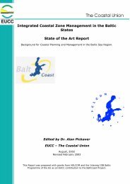
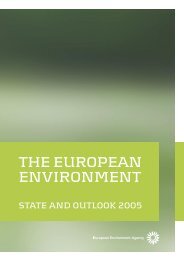
The links established with <strong>the</strong>se working groups have resolved some of <strong>the</strong> issues<br />
encountered by COAST and also highlighted areas that needed consideration and<br />
discussion (Figure 1);<br />
‣The working group leader, Claire Vincent, attended regular meetings of <strong>the</strong><br />
Strategic Co-ordination Group and Working Group Leaders in Brussels<br />
throughout <strong>the</strong> development of <strong>the</strong> Guidance.<br />
10
WFD CIS Guidance Document No. 5<br />
Transitional and Coastal <strong>Water</strong>s– Typology, Reference Conditions and Classification Systems<br />
COMMISSION<br />
STRATEGIC CO-ORDINATION GROUP<br />
WG 4.1<br />
Pilot River<br />
Basins<br />
ECOSTAT CLUSTER<br />
WG 2.3<br />
REFCOND<br />
WG 2.5<br />
IC<br />
WG 2.4<br />
COAST<br />
WG 2.1<br />
IMPRESS<br />
WG 2.2<br />
HMWB<br />
WG 2.7<br />
Monitoring<br />
CHARM Project<br />
Figure 1.1.<br />
Links between COAST, <strong>the</strong> Commission, o<strong>the</strong>r CIS working groups<br />
and European funded projects.<br />
11
WFD CIS Guidance Document No. 5<br />
Transitional and Coastal <strong>Water</strong>s– Typology, Reference Conditions and Classification Systems<br />
Section 2 – The <strong>Common</strong> Understanding of Terms related to<br />
Transitional and Coastal <strong>Water</strong>s.<br />
This Section provides guidance on <strong>the</strong> language used in <strong>the</strong> <strong>Directive</strong> <strong>for</strong><br />
transitional and coastal waters.<br />
2.1. DEFINITIONS OF TRANSITIONAL AND COASTAL WATERS<br />
2.1.1. The <strong>Directive</strong> defines transitional waters as:<br />
Article 2 (6)<br />
“‘Transitional waters’ are bodies of surface water in <strong>the</strong> vicinity of river mouths which<br />
are partly saline in character as a result of <strong>the</strong>ir proximity to coastal waters but which are<br />
substantially influenced by freshwater flows.”<br />
2.1.2. Fur<strong>the</strong>r guidance is given in Section 2.3 on defining transitional waters.<br />
2.1.3. The <strong>Directive</strong> defines coastal waters as:<br />
Article 2 (7)<br />
“‘Coastal water’ means surface water on <strong>the</strong> landward side of a line, every point of which<br />
is at a distance of one nautical mile on <strong>the</strong> seaward side from <strong>the</strong> nearest point of <strong>the</strong><br />
baseline from which <strong>the</strong> breadth of territorial waters is measured, extending where<br />
appropriate up to <strong>the</strong> outer limit of transitional waters.”<br />
2.1.4. The ecological status of coastal waters should be classified from <strong>the</strong> landward<br />
extent of ei<strong>the</strong>r <strong>the</strong> coastal or transitional waters out to one nautical mile from <strong>the</strong><br />
baseline. According to <strong>the</strong> United Nations Convention on <strong>the</strong> Law of <strong>the</strong> Sea<br />
(UNCLOS) <strong>the</strong> baseline is measured as <strong>the</strong> low-water line except along <strong>the</strong><br />
mouths of estuaries and heads of bays where it cuts across open water. Along<br />
highly indented coastlines, bays, mouths of estuaries or coastlines with islands,<br />
<strong>the</strong> baseline can be drawn as a straight line. Each Member State has a legislative<br />
baseline associated with this definition.<br />
2.1.5. The <strong>Directive</strong> gives no indication of <strong>the</strong> landward extent of ei<strong>the</strong>r transitional or<br />
coastal waters. One of <strong>the</strong> hydromorphological quality elements <strong>for</strong> both<br />
transitional and coastal waters is <strong>the</strong> structure of <strong>the</strong> intertidal zone. Since it is<br />
likely that some of <strong>the</strong> quality elements may be monitored within <strong>the</strong> intertidal<br />
area, it is recommended that transitional and coastal water bodies include <strong>the</strong><br />
intertidal area from <strong>the</strong> highest to <strong>the</strong> lowest astronomical tide.<br />
12
WFD CIS Guidance Document No. 5<br />
Transitional and Coastal <strong>Water</strong>s– Typology, Reference Conditions and Classification Systems<br />
2.2. DEFINING SURFACE WATER BODIES WITHIN TRANSITIONAL AND COASTAL<br />
WATERS<br />
Annex II 1.1<br />
“Member States shall identify <strong>the</strong> location and boundaries of bodies of surface water and<br />
shall carry out an initial characterisation of all such bodies”.<br />
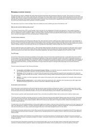
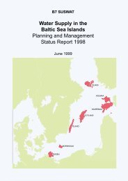
2.2.1. The <strong>Directive</strong> requires surface waters within <strong>the</strong> River Basin District to be split<br />
into water bodies (Figure 2.1). <strong>Water</strong> bodies represent <strong>the</strong> classification and<br />
management unit of <strong>the</strong> <strong>Directive</strong>. A range of factors will determine <strong>the</strong><br />
identification of water bodies. Some of <strong>the</strong>se will be determined by <strong>the</strong><br />
requirements of <strong>the</strong> <strong>Directive</strong> and o<strong>the</strong>rs by practical water management<br />
considerations.<br />
Define River<br />
Basin District [Article 3(1)]<br />
Divide surface waters into one of six surface<br />
water categories (i.e. rivers, lakes,<br />
transitional waters, coastal waters, artificial<br />
and heavily modified water bodies)<br />
[Annex II 1.1(i)]<br />
Iterative verification and<br />
refinement using in<strong>for</strong>mation<br />
from Annex II 1.5 risk<br />
assessments and Article 8<br />
monitoring programme<br />
Sub-divide surface water<br />
categories into types, using factors<br />
listed in Annex II, and assign<br />
surface waters to one type<br />
[Annex II 1.1(i)]<br />
Sub-divide a water body of one type<br />
into smaller water bodies according<br />
to pressures and resulting impacts<br />
[Purpose: to ensure water<br />
bodies can be used to<br />
provide an accurate<br />
description of <strong>the</strong> status of<br />
surface waters]<br />
Figure 2.1.<br />
Summary of suggested hierarchical approach to <strong>the</strong> identification of<br />
surface water bodies.<br />
13
WFD CIS Guidance Document No. 5<br />
Transitional and Coastal <strong>Water</strong>s– Typology, Reference Conditions and Classification Systems<br />
2.2.2. This paper provides guidance on defining water bodies specific to coastal and<br />
transitional waters. A separate horizontal Guidance Document is available which<br />
specifically gives guidance on <strong>the</strong> term ‘water body’ and <strong>the</strong> identification of<br />
water bodies (WFD CIS Guidance Document No 2.).<br />
Surface <strong>Water</strong> Categories<br />
Annex II 1.1(i)<br />
“The surface water bodies within <strong>the</strong> river basin district shall be identified as<br />
falling within ei<strong>the</strong>r one of <strong>the</strong> following surface water categories – rivers, lakes,<br />
transitional waters or coastal waters – or as artificial surface water bodies or<br />
heavily modified surface water bodies.”<br />
2.2.3. The first stage in describing surface water bodies is to assign all surface waters to<br />
a surface water category – rivers, lakes, transitional waters or coastal waters – or<br />
to artificial surface water bodies or heavily modified surface water bodies<br />
(Figure 2.2).<br />
Figure 2.2.<br />
Surface <strong>Water</strong> Categories.<br />
14
WFD CIS Guidance Document No. 5<br />
Transitional and Coastal <strong>Water</strong>s– Typology, Reference Conditions and Classification Systems<br />
Surface <strong>Water</strong> Types<br />
Annex II 1.1(ii)<br />
“For each surface water category, <strong>the</strong> relevant surface water bodies within <strong>the</strong> river basin<br />
district shall be differentiated according to type. These types are those defined using ei<strong>the</strong>r<br />
‘system A’ or ‘system B’.”<br />
2.2.4. The <strong>Directive</strong> recognises that <strong>the</strong> ecological character of surface waters will vary<br />
according to <strong>the</strong>ir different physical regimes. For example, a marine scientist<br />
expects to find different biological communities on an exposed Atlantic rocky<br />
shore compared to a fjord, a bay in <strong>the</strong> Baltic or a Mediterranean coastal lagoon.<br />
Examples of surface water types are shown in Figure 2.3. The purpose of<br />
assigning water bodies to a physical type is to ensure that valid comparisons of<br />
its ecological status can be made. For each type reference conditions must also be<br />
described, as <strong>the</strong>se <strong>for</strong>m <strong>the</strong> ‘anchor’ <strong>for</strong> classification of <strong>the</strong> water bodies status<br />
or quality. Guidance on how to type surface water bodies is given in Section 3.<br />
Figure 2.3.<br />
Types of surface water.<br />
15
WFD CIS Guidance Document No. 5<br />
Transitional and Coastal <strong>Water</strong>s– Typology, Reference Conditions and Classification Systems<br />
Surface <strong>Water</strong> Bodies<br />
Article 2(10)<br />
"Body of surface water" means a discrete and significant element of surface water such as<br />
a lake, a reservoir, a stream, river or canal, part of a stream, river or canal, a transitional<br />
water or a stretch of coastal water.<br />
2.2.5. The water body is <strong>the</strong> management unit of <strong>the</strong> <strong>Directive</strong>.<br />
2.2.6. <strong>Water</strong> bodies may be identified <strong>for</strong> all surface waters (natural, heavily modified<br />
and artificial waters). This step is of major importance <strong>for</strong> <strong>the</strong> implementation<br />
process because water bodies represent <strong>the</strong> units that will be used <strong>for</strong> reporting<br />
and assessing compliance with <strong>the</strong> <strong>Directive</strong>’s principal environmental<br />
objectives.<br />
2.2.7. To assign a single classification and effective environmental objectives to a water<br />
body it may be necessary to divide an area which is of one type fur<strong>the</strong>r into two<br />
or more separate water bodies (Figure 2.4.). <strong>Water</strong> bodies may not spread over<br />
two types because reference conditions and hence environmental objectives are<br />
type specific.<br />
Figure 2.4.<br />
Surface water bodies. The colours used relate to those stated in<br />
Annex V 1.4.2 <strong>for</strong> reporting.<br />
16
WFD CIS Guidance Document No. 5<br />
Transitional and Coastal <strong>Water</strong>s– Typology, Reference Conditions and Classification Systems<br />
2.2.8. According to <strong>the</strong> definition in <strong>the</strong> <strong>Directive</strong>, water bodies must be “discrete and<br />
significant”. This means that <strong>the</strong>y must not be arbitrary sub-divisions of river<br />
basin districts, that <strong>the</strong>y must not overlap with each o<strong>the</strong>r, nor be composed of<br />
elements of surface water that are not contiguous.<br />
2.2.9. The <strong>Directive</strong> specifies that rivers and coastal waters may be sub-divided. It is<br />
assumed that transitional waters may also be sub-divided as long as <strong>the</strong> resulting<br />
water bodies are discrete and significant (Figure 2.5). In <strong>the</strong> case of coastal<br />
waters, stretches of open coast are often continuous (unless divided by<br />
transitional waters); here subdivisions may follow significant changes in<br />
substratum, topographies or aspect.<br />
Surface water<br />
categories<br />
Lakes<br />
Surface water<br />
bodies<br />
Part of a lake<br />
Rivers, streams,<br />
canals<br />
Part of a river,<br />
stream, canal<br />
Surface<br />
waters<br />
Transitional<br />
waters<br />
Coastal waters<br />
Artificial water<br />
bodies<br />
Part of a<br />
transitional water<br />
Stretch of coastal<br />
water<br />
Heavily<br />
modified water<br />
bodies<br />
Figure 2.5.<br />
The splitting of surface water categories into surface water bodies.<br />
2.2.10. The need to keep separate two or more contiguous water bodies of <strong>the</strong> same type<br />
depends upon <strong>the</strong> pressures and resulting impacts. For example, a discharge<br />
may cause organic enrichment in one water body but not in <strong>the</strong> o<strong>the</strong>r. Such an<br />
area of one type could <strong>the</strong>re<strong>for</strong>e be divided into two separate water bodies with<br />
different classifications. If <strong>the</strong>re were no impact from <strong>the</strong> discharge it would not<br />
be necessary to divide <strong>the</strong> area into two water bodies as it would have <strong>the</strong> same<br />
classification and should be managed as one entity.<br />
17
WFD CIS Guidance Document No. 5<br />
Transitional and Coastal <strong>Water</strong>s– Typology, Reference Conditions and Classification Systems<br />
Look out! The <strong>Directive</strong> only requires sub-divisions of surface water that<br />
are necessary <strong>for</strong> <strong>the</strong> clear, consistent and effective application of its<br />
objectives. Sub-divisions of coastal and transitional waters into smaller<br />
and smaller water bodies that do not support this purpose should be<br />
avoided.<br />
2.2.11. Every six years from 2013, Member States must review <strong>the</strong> characterisation of<br />
water bodies, including <strong>the</strong> type-specific reference conditions, so as to reflect<br />
greater understanding and knowledge of <strong>the</strong> systems and natural variability<br />
including climate change. In this review, water bodies whose status changes may<br />
be merged with adjacent water bodies of <strong>the</strong> same status and <strong>the</strong> same type.<br />
Article 5(2)<br />
“The analyses and reviews mentioned under” [Article 5] “paragraph 1 shall be reviewed,<br />
and if necessary updated at <strong>the</strong> latest 13 years after <strong>the</strong> date of entry into <strong>for</strong>ce of this<br />
<strong>Directive</strong> and every six years <strong>the</strong>reafter.”<br />
2.3. DEFINING TRANSITIONAL WATERS<br />
2.3.1. The <strong>Directive</strong> defines transitional waters as:<br />
Article 2 (6)<br />
“‘Transitional waters’ are bodies of surface water in <strong>the</strong> vicinity of river mouths which<br />
are partly saline in character as a result of <strong>the</strong>ir proximity to coastal waters but which are<br />
substantially influenced by freshwater flows.”<br />
2.3.2. When defining transitional waters <strong>for</strong> <strong>the</strong> purposes of <strong>the</strong> WFD, it is clear that<br />
<strong>the</strong> setting of boundaries between transitional waters, freshwaters and coastal<br />
waters must be ecologically relevant.<br />
2.3.3. Transitional waters are:<br />
(1) "...in <strong>the</strong> vicinity of a river mouth" meaning close to <strong>the</strong> end of a river where it<br />
mixes with coastal waters;<br />
(2)"...partly saline in character” meaning that <strong>the</strong> salinity is generally lower than<br />
in <strong>the</strong> adjacent coastal water;<br />
(3)"...substantially influenced by freshwater flow" meaning that <strong>the</strong>re is a change<br />
to salinity or flow.<br />
2.3.4. If riverine dynamics occur in a plume outside <strong>the</strong> coastline because of high and<br />
strong freshwater discharge, <strong>the</strong> transitional water may extend into <strong>the</strong> sea area<br />
(allowed in definition 1).<br />
2.3.5. For <strong>the</strong> purposes of <strong>the</strong> <strong>Directive</strong>, <strong>the</strong> main difference between transitional and<br />
coastal waters is <strong>the</strong> inclusion of <strong>the</strong> abundance and composition of fish fauna in<br />
18
WFD CIS Guidance Document No. 5<br />
Transitional and Coastal <strong>Water</strong>s– Typology, Reference Conditions and Classification Systems<br />
<strong>the</strong> list of biological quality elements <strong>for</strong> <strong>the</strong> classification assessment of<br />
transitional waters.<br />
2.3.6. Transitional waters are usually characterised by <strong>the</strong>ir morphological and<br />
chemical features in relation to <strong>the</strong> size and nature of <strong>the</strong> inflowing rivers. Many<br />
different methods might be used to define <strong>the</strong>m but <strong>the</strong> method should be<br />
relevant ecologically. This will ensure reliable derivation of type-specific<br />
biological reference conditions.<br />
2.3.7. In certain areas of <strong>the</strong> Baltic Sea, such as <strong>the</strong> Bothnian Bay, <strong>the</strong> salinity of coastal<br />
water is similar to that of fresh water. As a result riverine fresh water life may<br />
extend into <strong>the</strong> adjacent coastal water. However, because of <strong>the</strong> different<br />
physical characteristics (flow dynamics) of a river and coastal water (Article<br />
2(6)), <strong>the</strong> same biological community falls into two different categories of surface<br />
waters (river - coastal) and hence must be separated into two different water<br />
bodies, as required by <strong>the</strong> <strong>Directive</strong>. In such cases <strong>the</strong> delimitation of a<br />
transitional water might be superfluous.<br />
Defining <strong>the</strong> seaward boundary of transitional waters<br />
2.3.8. To assist Member States in defining <strong>the</strong> seaward boundary of transitional waters,<br />
four methods are proposed.<br />
1. The use of boundaries defined under o<strong>the</strong>r European and national<br />
legislation such as <strong>the</strong> Urban Waste <strong>Water</strong> Treatment <strong>Directive</strong>;<br />
2. Salinity gradient;<br />
3. Physiographic features;<br />
4. Modelling.<br />
2.3.9. Member States should select <strong>the</strong> most ecologically relevant method <strong>for</strong> <strong>the</strong>ir own<br />
situation. The use of one or more of <strong>the</strong>se approaches will allow comparisons<br />
across all Member States.<br />
The use of boundaries defined under o<strong>the</strong>r European and National legislation<br />
2.3.10. Where boundaries of transitional waters were defined <strong>for</strong> <strong>the</strong> purposes of<br />
existing legislation, <strong>the</strong>y may be used to define transitional waters under <strong>the</strong><br />
WFD as long as <strong>the</strong>y are consistent with <strong>the</strong> WFD categories.<br />
2.3.11. Article 17(1) and (2) of <strong>the</strong> Urban Waste <strong>Water</strong> Treatment <strong>Directive</strong> (91/271/EC)<br />
gave Member States <strong>the</strong> task of establishing an implementation programme to<br />
include in<strong>for</strong>mation on discharges into different types of water bodies, which<br />
might have implicated defining <strong>the</strong> outer (seaward) limit of estuaries. Each<br />
Member State used its own individual method. These boundaries are likely to<br />
have been drawn <strong>for</strong> most sizeable estuaries and could be used to define<br />
transitional waters <strong>for</strong> <strong>the</strong> purposes of <strong>the</strong> WFD.<br />
19
WFD CIS Guidance Document No. 5<br />
Transitional and Coastal <strong>Water</strong>s– Typology, Reference Conditions and Classification Systems<br />
Salinity gradient<br />
2.3.12. If salinity measurements exist, <strong>the</strong> outer boundary should be drawn where <strong>the</strong><br />
salinity of <strong>the</strong> transitional water is usually substantially lower than <strong>the</strong> salinity of<br />
<strong>the</strong> adjacent coastal water. By definition, <strong>the</strong> transitional water must also be<br />
substantially influenced by freshwater flows.<br />
2.3.13. For larger rivers <strong>the</strong> influence of freshwater is likely to extend into coastal waters<br />
(Figure 2.6).<br />
Figure 2.6.<br />
Examples of <strong>the</strong> plumes of <strong>the</strong> Loire and Gironde estuaries on <strong>the</strong><br />
French Atlantic coast. The extension of <strong>the</strong> plume (salinity gradient)<br />
varies according to freshwater flow and tide conditions.<br />
Physiographic features<br />
2.3.14. Where morphological boundaries lie close to enclosing geographic features such<br />
as headlands and islands, such features may be used to define <strong>the</strong> boundary.<br />
20
WFD CIS Guidance Document No. 5<br />
Transitional and Coastal <strong>Water</strong>s– Typology, Reference Conditions and Classification Systems<br />
This is acceptable in some cases such as bar-built estuaries (Figure 2.7) whose<br />
morphological features may also coincide with biological boundaries.<br />
Figure 2.7.<br />
Bar-built estuary showing that geomorphological and biological limits<br />
of transitional waters can coincide.<br />
Modelling<br />
2.3.15 Models may be designed to predict <strong>the</strong> size of transitional waters. This method<br />
may be applicable where no estuary boundary has been defined <strong>for</strong> <strong>the</strong> purpose<br />
of existing legislation and where no suitable salinity data are available. Models<br />
may be used to estimate <strong>the</strong> area of water of a salinity substantially less than <strong>the</strong><br />
salinity of <strong>the</strong> adjacent coastal water.<br />
21
WFD CIS Guidance Document No. 5<br />
Transitional and Coastal <strong>Water</strong>s– Typology, Reference Conditions and Classification Systems<br />
Defining <strong>the</strong> freshwater boundary of transitional waters<br />
2.3.16. Annex II 1.2.3. and 1.2.4 of <strong>the</strong> <strong>Directive</strong> defines freshwater as less than 0.5<br />
salinity.<br />
2.3.17. There are two main methods <strong>for</strong> defining <strong>the</strong> freshwater boundary of transitional<br />
waters: <strong>the</strong> fresh/salt water boundary or <strong>the</strong> tidal limit (Figure 2.8). In some large<br />
estuaries, <strong>the</strong> tidal limit can be several tens of kilometres fur<strong>the</strong>r inland than <strong>the</strong><br />
freshwater/salt water boundary.<br />
<br />
<br />
<br />
<br />
<br />
<br />
<br />
<br />
<br />
Ei<strong>the</strong>r boundary can be ecologically<br />
relevant<br />
Figure 2.8.<br />
Methods <strong>for</strong> defining <strong>the</strong> freshwater boundary of transitional waters.<br />
2.3.18. It is suggested that ei<strong>the</strong>r <strong>the</strong> fresh /salt boundary or <strong>the</strong> tidal limit be used to<br />
define <strong>the</strong> freshwater boundary of transitional waters depending upon which<br />
method is most suitable to local circumstances. Whichever method is used, it is<br />
clear that all transitional waters must abut freshwater, leaving no section of <strong>the</strong><br />
system unassigned to a surface water category.<br />
The Minimum Size of Transitional <strong>Water</strong>s<br />
2.3.19. The <strong>Directive</strong> gives no indication of <strong>the</strong> minimum size of transitional waters to<br />
be identified as separate water bodies. Although catchment size may be used as a<br />
guideline <strong>for</strong> <strong>the</strong> size of identified transitional waters, it should be considered<br />
with o<strong>the</strong>r factors such as <strong>the</strong> size, length, volume, river, discharge and <strong>the</strong><br />
22
WFD CIS Guidance Document No. 5<br />
Transitional and Coastal <strong>Water</strong>s– Typology, Reference Conditions and Classification Systems<br />
nature of <strong>the</strong> mixing zone. Most importantly it must meet <strong>the</strong> water body<br />
definition (Article 2.10) of being a ‘discrete and significant’ element of surface<br />
water. Significant could mean in terms of size or risk of failing to meet good<br />
ecological status.<br />
2.3.20. The horizontal Guidance on water bodies (WFD CIS Guidance Document No. 2)<br />
gives no guidance on <strong>the</strong> minimum size <strong>for</strong> transitional or coastal water bodies.<br />
It does however state that Member States have <strong>the</strong> flexibility to decide whe<strong>the</strong>r<br />
<strong>the</strong> purposes of <strong>the</strong> <strong>Directive</strong>, which apply to all surface waters, can be achieved<br />
without <strong>the</strong> identification of every minor but discrete element of surface water as<br />
a water body.<br />
2.4. ASSIGNING COASTAL WATERS WITHIN THE RIVER BASIN DISTRICT<br />
Article 3.1<br />
“Coastal waters shall be identified and assigned to <strong>the</strong> nearest or most appropriate river<br />
basin district or districts.”<br />
3.4.1. The free exchange of substances from river basin districts to <strong>the</strong> open sea takes<br />
place in coastal waters. Coastal waters must be assigned to a River Basin District.<br />
This may involve <strong>the</strong> splitting of stretches of coastal water that might o<strong>the</strong>rwise<br />
be considered as single water bodies.<br />
2.4.2. When assigning a stretch of coastal water to a River Basin District <strong>the</strong> objective is<br />
to ensure that coastal waters are assigned to <strong>the</strong> closest possible or <strong>the</strong> most<br />
appropriate natural management unit and to minimise any unnecessary splitting<br />
of coastal stretches. To ensure consistency in <strong>the</strong> approach, <strong>the</strong> following<br />
principles should be applied:<br />
Where possible, existing administrative boundaries could be used.<br />
Examples are, ecoregions defined within <strong>the</strong> <strong>Directive</strong> and regions<br />
defined in <strong>the</strong> Marine Conventions;<br />
The boundaries between two adjacent types should be used wherever<br />
possible to minimise unnecessary splitting of <strong>the</strong> coastline;<br />
In <strong>the</strong> general case, <strong>the</strong> coastline should be split at open coast areas ra<strong>the</strong>r<br />
than through natural management units such as bays or inlets. However,<br />
specific situations may exist where <strong>the</strong> splitting of natural units <strong>for</strong><br />
management purposes can not be avoided.<br />
Look out! Fur<strong>the</strong>r details on assigning coastal stretches to River Basin<br />
Districts are given in <strong>the</strong> Guidance Document “Identification of River<br />
Basin Districts in Member States. Overview, criteria and current state of<br />
play” produced by working group 2.9.<br />
23
WFD CIS Guidance Document No. 5<br />
Transitional and Coastal <strong>Water</strong>s– Typology, Reference Conditions and Classification Systems<br />
2.4.3. When managing coastal water bodies it must be recognized that water bodies in<br />
different river basin districts may interact to affect water quality in adjacent<br />
water bodies or even fur<strong>the</strong>r away. In this case, <strong>the</strong> management plans of both<br />
river basins should acknowledge <strong>the</strong> problem and work toge<strong>the</strong>r to resolve any<br />
issues. Where possible <strong>the</strong> coastal water body should be assigned to <strong>the</strong> River<br />
Basin District most likely to influence its quality, particularly taking into account<br />
long-shore influences of any contaminants.<br />
2.5. TERRITORIAL WATERS<br />
Article 2. 1<br />
“‘Surface water’ means inland waters, except groundwater; transitional and coastal<br />
waters, except in respect of chemical status <strong>for</strong> which it shall also include territorial<br />
waters.”<br />
2.5.1. The definition of surface waters includes territorial waters. The <strong>Directive</strong><br />
requires <strong>the</strong> achievement of good surface water chemical status <strong>for</strong> all surface<br />
water up to 12 nautical miles seaward from <strong>the</strong> baseline from which territorial<br />
waters are measured (i.e. territorial waters).<br />
2.5.2. However, Member States are only required to identify water bodies in coastal<br />
waters, not in territorial waters.<br />
Article 2. 10<br />
“‘Body of surface water’ means a discrete and significant element of surface water such as<br />
a lake, a reservoir, a stream, river or canal, part of a stream, river or canal, a transitional<br />
water or a stretch of coastal water.’”<br />
2.5.3. By protecting <strong>the</strong>se inland surface waters, transitional waters, coastal waters and<br />
groundwaters, <strong>the</strong> <strong>Directive</strong> contributes to <strong>the</strong> protection of territorial and marine<br />
waters.<br />
2.5.4. It is intended that <strong>the</strong> daughter directives that must be proposed by <strong>the</strong><br />
Commission <strong>for</strong> substances on <strong>the</strong> Priority List by 20 November 2003 will clarify<br />
<strong>the</strong> compliance, assessment and reporting requirements relevant to <strong>the</strong><br />
classification of good surface water chemical status.<br />
2.5.5. One option <strong>for</strong> reporting any failures to achieve good surface water chemical<br />
status in territorial waters would be to identify territorial water bodies only<br />
where needed to delineate contiguous stretches of water in which <strong>the</strong> required<br />
environmental quality standards <strong>for</strong> good chemical status are not being met.<br />
24
WFD CIS Guidance Document No. 5<br />
Transitional and Coastal <strong>Water</strong>s– Typology, Reference Conditions and Classification Systems<br />
2.6. MARINE LAGOONS<br />
2.6.1. Coastal lagoons may be ei<strong>the</strong>r coastal waters or transitional waters, depending<br />
on whe<strong>the</strong>r <strong>the</strong> lagoon fits <strong>the</strong> definition of transitional waters in <strong>the</strong> <strong>Directive</strong><br />
“in <strong>the</strong> vicinity of river mouths” and “substantially influenced by freshwater flows”<br />
(Article 2(6)).<br />
2.6.2. All surface waters are covered by <strong>the</strong> <strong>Directive</strong>. The minimum size of lagoons to<br />
be covered by <strong>the</strong> <strong>Directive</strong> is here suggested to be <strong>the</strong> same as <strong>the</strong> minimum size<br />
of lakes. Within Annex II of <strong>the</strong> <strong>Directive</strong>, <strong>the</strong> smallest size of lakes included in<br />
System A is a surface area of 0.5 to 1 km 2 . This must not be considered as an<br />
absolute value and Member States may wish to include lagoons smaller than<br />
0.5 km 2 , particularly if <strong>the</strong>y are at risk of failing to meet good status or are at high<br />
status and require a high level of protection. Fur<strong>the</strong>r in<strong>for</strong>mation on significant<br />
water bodies is given in <strong>the</strong> horizontal Guidance on water bodies (WFD CIS<br />
Guidance Document No. 2).<br />
2.7. WETLANDS<br />
Look out! A horizontal Guidance paper (currently under preparation)<br />
deals with <strong>the</strong> role of wetlands in <strong>the</strong> WFD and should be referred to <strong>for</strong><br />
more detailed discussion.<br />
Article 1<br />
“The purpose of this <strong>Directive</strong> is to establish a framework <strong>for</strong> <strong>the</strong> protection of inland<br />
surface waters, transitional waters, coastal waters and groundwater which:<br />
(a) prevents fur<strong>the</strong>r deterioration and protects and enhances <strong>the</strong> status of aquatic<br />
ecosystems, and with regard to <strong>the</strong>ir water needs, terrestrial ecosystems and wetlands<br />
directly dependent on aquatic ecosystems.”<br />
2.7.1. It is clear from Article 1 of <strong>the</strong> <strong>Directive</strong> that one of <strong>the</strong> primary objectives of <strong>the</strong><br />
WFD is to protect and enhance aquatic ecosystems including wetlands directly<br />
dependent on aquatic ecosystems. The major strength of <strong>the</strong> WFD as a<br />
management tool is that <strong>the</strong>se interdependencies are recognised, in contrast to<br />
previous water pollution control or nature conservation directives.<br />
Look out! Although specific Guidance on marine wetlands is not covered<br />
within this Guidance Document, <strong>the</strong> importance of wetlands associated<br />
with coastal and transitional waters, in particular salt marshes, is<br />
recognised.<br />
25
WFD CIS Guidance Document No. 5<br />
Transitional and Coastal <strong>Water</strong>s– Typology, Reference Conditions and Classification Systems<br />
2.7.2. Wetland ecosystems are ecologically and functionally significant elements of <strong>the</strong><br />
water environment, with potentially an important role to play in helping to<br />
achieve sustainable river basin management. The <strong>Water</strong> <strong>Framework</strong> <strong>Directive</strong><br />
does not set environmental objectives <strong>for</strong> wetlands. However, wetlands that are<br />
dependent on groundwater bodies, <strong>for</strong>m part of a surface water body, or are<br />
Protected Areas, will benefit from WFD obligations to protect and restore <strong>the</strong><br />
status of water. Relevant definitions are developed in CIS horizontal Guidance<br />
Documents water bodies (WFD CIS Guidance Document No. 2) and fur<strong>the</strong>r<br />
considered in <strong>the</strong> Guidance Document on wetlands (currently under<br />
preparation).<br />
2.7.3. Pressures on wetlands (<strong>for</strong> example physical modification or pollution) can result<br />
in impacts on <strong>the</strong> ecological status of water bodies. Measures to manage such<br />
pressures may <strong>the</strong>re<strong>for</strong>e need to be considered as part of river basin management<br />
plans, where <strong>the</strong>y are necessary to meet <strong>the</strong> environmental objectives of <strong>the</strong><br />
<strong>Directive</strong>.<br />
2.7.4. Wetland creation and enhancement can in appropriate circumstances offer<br />
sustainable, cost-effective and socially acceptable mechanisms <strong>for</strong> helping to<br />
achieve <strong>the</strong> environmental objectives of <strong>the</strong> <strong>Directive</strong>. In particular, wetlands can<br />
help to abate pollution impacts, contribute to mitigating <strong>the</strong> effects of droughts<br />
and floods, help to achieve sustainable coastal management and to promote<br />
groundwater recharge. The relevance of wetlands within programmes of<br />
measures is examined fur<strong>the</strong>r in a separate horizontal Guidance paper on<br />
wetlands (currently under preparation).<br />
26
WFD CIS Guidance Document No. 5<br />
Transitional and Coastal <strong>Water</strong>s– Typology, Reference Conditions and Classification Systems<br />
Section 3 – Guidance <strong>for</strong> Typology in Transitional and Coastal<br />
<strong>Water</strong>s.<br />
This Section interprets <strong>the</strong> requirements of <strong>the</strong> WFD to define typology as one of <strong>the</strong><br />
supporting factors in determining ecological status.<br />
3.1. INTRODUCTION TO TYPOLOGY<br />
Article 5(1).<br />
“Each Member State shall ensure that <strong>for</strong> each river basin district or <strong>for</strong> <strong>the</strong> portion of an<br />
international river basin district falling within its territory:<br />
- an analysis of its characteristics”…<br />
…”is undertaken according to <strong>the</strong> technical specifications set out in Annexes II and III<br />
and that it is completed at <strong>the</strong> latest four years after <strong>the</strong> date of entry into <strong>for</strong>ce of this<br />
<strong>Directive</strong>.”<br />
3.1.1. Article 5 of <strong>the</strong> <strong>Directive</strong> requires Member States to carry out a characterisation<br />
of all water bodies. This exercise is referred to as typology. It is one of <strong>the</strong> first<br />
stages in <strong>the</strong> implementation of <strong>the</strong> WFD.<br />
3.1.2. Annex II of <strong>the</strong> <strong>Directive</strong> gives instructions on how typology should be carried<br />
out and <strong>the</strong> obligatory and optional factors that can be used.<br />
3.1.3. The purpose of typology is to enable type specific reference conditions to be<br />
established. These <strong>the</strong>n become <strong>the</strong> anchor <strong>for</strong> classification systems. Typology<br />
has consequences <strong>for</strong> all subsequent operational aspects of <strong>the</strong> implementation of<br />
<strong>the</strong> <strong>Directive</strong> including monitoring, assessment and reporting.<br />
Look out! Typology should be completed as soon as possible because all<br />
successive steps of Annexes II and V build on typology. In addition, <strong>the</strong><br />
selection of types and sites <strong>for</strong> <strong>the</strong> draft register to <strong>for</strong>m <strong>the</strong><br />
intercalibration network is needed in 2003.<br />
3.1.4. When carrying out typology Member States should focus on <strong>the</strong> overall purpose<br />
of <strong>the</strong> <strong>Directive</strong> outlined in Article 1; to establish a framework <strong>for</strong> <strong>the</strong> protection<br />
of both water quality and water resources preventing fur<strong>the</strong>r deterioration and<br />
protecting and enhancing ecosystems. Typology is simply a tool to assist this<br />
process by comparing like with like.<br />
27
WFD CIS Guidance Document No. 5<br />
Transitional and Coastal <strong>Water</strong>s– Typology, Reference Conditions and Classification Systems<br />
Look out! The aim of typology is to produce as simple a physical<br />
typology as possible that is both ecologically relevant and practical to<br />
implement. It is recognised that a simple typology system needs to be<br />
complemented by more complex reference conditions that cover ranges<br />
of biological conditions.<br />
3.1.5. The final typology should be submitted to <strong>the</strong> Commission in <strong>the</strong> <strong>for</strong>m of GIS<br />
map(s) by 2004.<br />
Annex II 1.1(vi)<br />
“Member States shall submit to <strong>the</strong> Commission a map or maps (in a GIS <strong>for</strong>mat) of <strong>the</strong><br />
geographical location of <strong>the</strong> types”.<br />
3.2. THE PROCESS OF TYPING<br />
3.2.1. According to Annex II, Member States shall assign surface water bodies to one of<br />
<strong>the</strong> following categories: rivers, lakes, transitional, coastal, artificial or heavily<br />
modified surface water bodies. These categories must <strong>the</strong>n be fur<strong>the</strong>r divided<br />
into types.<br />
Annex II 1.1(ii)<br />
“For each surface water category, <strong>the</strong> relevant surface water bodies within <strong>the</strong> river basin<br />
district shall be differentiated according to type. These types are those defined using ei<strong>the</strong>r<br />
‘system A’ or ‘system B’”<br />
3.2.2. <strong>Water</strong> bodies within each surface water category are differentiated according to<br />
type using a system of typology as defined in Annex II of <strong>the</strong> <strong>Directive</strong>. Member<br />
States may choose to use ei<strong>the</strong>r System A or System B.<br />
3.2.3. If system A is used <strong>the</strong> type must first be assigned to an Ecoregion as shown in<br />
Map B of <strong>the</strong> <strong>Directive</strong> (Figure 3.1). In transitional waters <strong>the</strong> surface water type<br />
is <strong>the</strong>n described according to mean annual salinity and mean tidal range. In<br />
coastal waters mean annual salinity and mean depth are used to describe <strong>the</strong><br />
type. The COAST working group held <strong>the</strong> opinion that <strong>the</strong> class limits defined<br />
<strong>for</strong> <strong>the</strong> various descriptors by system A are not always ecologically relevant <strong>for</strong><br />
<strong>the</strong> local environmental conditions.<br />
Annex II 1.1(iv)<br />
“If system B is used, Member States must achieve at least <strong>the</strong> same degree of<br />
differentiation as would be achieved using System A. Accordinly, <strong>the</strong> surface water<br />
bodies within <strong>the</strong> river basin district shall be differentiated into types using <strong>the</strong> values <strong>for</strong><br />
<strong>the</strong> obligatory descriptors and such optional descriptors, or combinations of descriptors,<br />
as are required to ensure that type specific biological reference conditions can be reliably<br />
derived.”<br />
28
WFD CIS Guidance Document No. 5<br />
Transitional and Coastal <strong>Water</strong>s– Typology, Reference Conditions and Classification Systems<br />
3.2.4. The <strong>Directive</strong> states that if Member States choose to use system B at least <strong>the</strong><br />
same degree of differentiation must be achieved as if system A were used.<br />
System B uses a series of obligatory (e.g. tidal range and salinity) and optional<br />
factors (e.g. mean substratum composition, current velocity) in order to classify<br />
surface waters into types.<br />
3.2.5. Most Member States have expressed <strong>the</strong> opinion that system B will be applied.<br />
This is because <strong>the</strong> differences in biological compositions and community<br />
structures normally depend on more descriptors than those in system A.<br />
3.3. THE DEVELOPMENT OF TYPOLOGY GUIDANCE<br />
3.3.1. The <strong>Directive</strong> does not prescribe a scientific methodology as to how Member<br />
States should type <strong>the</strong>ir surface waters.<br />
3.3.2. The ecological approach to assessing <strong>the</strong> quality of Europe's transitional and<br />
coastal waters takes into account biological differences caused by land-ocean<br />
interactions and climatic zones. There<strong>for</strong>e, <strong>the</strong> starting point <strong>for</strong> managing <strong>the</strong><br />
scientific development of types of water bodies is a separation into broad<br />
ecoregions based on accepted marine biological provinces.<br />
3.3.3. On <strong>the</strong> basis of <strong>the</strong> 'Obligatory Factors' in system B (latitude, longitude, tidal<br />
range and salinity), it is possible to split <strong>the</strong> maritime area into three basic<br />
Ecoregions/Ecoregion Complexes:<br />
Atlantic/North Sea Ecoregion Complex comprises North Atlantic Ocean,<br />
North Sea, Norwegian Sea and <strong>the</strong> Barents Sea Ecoregions. A general<br />
physical description shows mostly full salinity regimes and moderate to<br />
higher hydrodynamic properties;<br />
Baltic Sea Ecoregion with brackish waters and mostly low hydrodynamic<br />
properties;<br />
Mediterranean Sea Ecoregion with euhaline waters and moderate<br />
hydrodynamic properties.<br />
3.3.4. These Ecoregions are shown on Map B in <strong>the</strong> <strong>Directive</strong> (Figure 3.1).<br />
29
WFD CIS Guidance Document No. 5<br />
Transitional and Coastal <strong>Water</strong>s– Typology, Reference Conditions and Classification Systems<br />
Figure 3.1.<br />
Map B from <strong>the</strong> <strong>Directive</strong>. System A: Ecoregions <strong>for</strong> transitional and<br />
coastal waters. The North-East Atlantic eco-region complex referred to<br />
in this Guidance Document includes <strong>the</strong> Atlantic Ocean, Norwegian<br />
Sea, Barents Sea and North Sea.<br />
3.3.5. The Guidance was developed at three Ecoregion workshops by investigating:<br />
<br />
<br />
<br />
<strong>the</strong> common key optional factors within each Ecoregion;<br />
<strong>the</strong> order in which optional factors could be used to achieve <strong>the</strong><br />
appropriate level of differentiation;<br />
<strong>the</strong> way in which <strong>the</strong> optional factors could be used.<br />
30
WFD CIS Guidance Document No. 5<br />
Transitional and Coastal <strong>Water</strong>s– Typology, Reference Conditions and Classification Systems<br />
3.4. COMMON FRAMEWORK FOR THE USE OF FACTORS FOR SYSTEM B<br />
3.4.1. The factors listed in Annex II <strong>for</strong> coastal and transitional waters under System B<br />
are as follows:<br />
Annex II 1.2.3. Transitional <strong>Water</strong>s<br />
System B<br />
Alternative Physical and chemical factors that determine <strong>the</strong> characteristics of <strong>the</strong><br />
Characterisation transitional water and hence <strong>the</strong> biological population structure and<br />
composition<br />
Obligatory factors latitude<br />
longitude<br />
tidal range<br />
salinity<br />
Optional factors depth<br />
current velocity<br />
wave exposure<br />
residence time<br />
mean water temperature<br />
mixing characteristics<br />
turbidity<br />
mean substratum composition<br />
shape<br />
water temperature range<br />
Annex II 1.2.4. Coastal <strong>Water</strong>s<br />
System B<br />
Alternative Physical and chemical factors that determine <strong>the</strong> characteristics of <strong>the</strong><br />
Characterisation coastal water and hence <strong>the</strong> biological population structure and<br />
composition<br />
Obligatory factors latitude<br />
longitude<br />
tidal range<br />
salinity<br />
Optional factors current velocity<br />
wave exposure<br />
mean water temperature<br />
mixing characteristics<br />
turbidity<br />
retention time (of enclosed bays)<br />
mean substratum composition<br />
water temperature range<br />
3.4.2. From <strong>the</strong> set of factors listed in Annex II of <strong>the</strong> <strong>Directive</strong>, Member States should<br />
use <strong>the</strong> obligatory factors followed by <strong>the</strong> optional factors that are most<br />
applicable to <strong>the</strong>ir own ecological situation.<br />
31
WFD CIS Guidance Document No. 5<br />
Transitional and Coastal <strong>Water</strong>s– Typology, Reference Conditions and Classification Systems<br />
3.4.3. It is suggested that a hierarchical approach is used <strong>for</strong> use of <strong>the</strong> optional factors<br />
when using System B.<br />
<br />
First use obligatory factors<br />
- Latitude/Longitude - Ecoregion (c.f. Annex 11 of <strong>the</strong> <strong>Directive</strong>, Map<br />
B) (Figure 3.1 above);<br />
- Tidal Range;<br />
- Salinity.<br />
3.4.4. If ecological separation to define <strong>the</strong> type specific reference conditions can be<br />
achieved by using only <strong>the</strong> obligatory factors, <strong>the</strong> use of optional factors is<br />
unnecessary.<br />
3.4.5. If ecological separation to define <strong>the</strong> type specific reference conditions according<br />
to types cannot be achieved by using only <strong>the</strong> obligatory factors, <strong>the</strong>n optional<br />
factors should also be used.<br />
3.4.6. In transitional waters, <strong>the</strong> optional factors may be used in <strong>the</strong> following order if<br />
possible:<br />
- Mixing;<br />
- Intertidal Area (as an integrator of depth, tidal range and shape);<br />
- Residence time;<br />
- O<strong>the</strong>r factors until an ecologically relevant type of water body is achieved.<br />
3.4.7. In coastal waters, <strong>the</strong> optional factors may be used in <strong>the</strong> following order if<br />
possible:<br />
- Wave exposure;<br />
- Depth (not in Annex II list);<br />
- O<strong>the</strong>r factors until an ecologically relevant type of water body is achieved.<br />
Look out! Even if only several factors are used to describe a type, it is<br />
suggested that Member States describe each water body using all factors<br />
in order to allow comparison of types between Member States. This will<br />
also aid <strong>the</strong> intercalibration exercise.<br />
32
WFD CIS Guidance Document No. 5<br />
Transitional and Coastal <strong>Water</strong>s– Typology, Reference Conditions and Classification Systems<br />
3.5. HOW COULD THE FACTORS BE USED?<br />
3.5.1. Each factor has been split into several ranges on <strong>the</strong> basis of <strong>the</strong> ecological<br />
relevance across <strong>the</strong> three ecoregions.<br />
3.5.2. Working within <strong>the</strong> agreed ranges will<br />
ensure true comparability between Member States on types;<br />
enable <strong>the</strong> identification of common types which could be used <strong>for</strong><br />
intercalibration.<br />
Look out! The Guidance was agreed on <strong>the</strong> understanding that:<br />
Member States may fur<strong>the</strong>r split descriptors within <strong>the</strong>se ranges if<br />
this is necessary to achieve an ecologically relevant type;<br />
Member States may aggregate descriptors within <strong>the</strong>se ranges if <strong>the</strong>re<br />
is no biological difference.<br />
3.5.3. Salinity<br />
In defining types <strong>the</strong> ranges of <strong>the</strong> broadly in line with system A of <strong>the</strong><br />
<strong>Directive</strong> should be used.<br />
freshwater < 0.5 (‰)<br />
oligohaline 0.5 to 5 - 6 (‰)<br />
mesohaline 5 - 6 to 18 - 20 (‰)<br />
polyhaline 18 – 20 to 30 (‰)<br />
euhaline >higher than 30 (‰)<br />
3.5.4. Mean Spring Tidal Range (astronomical)<br />
micro tidal < 1 m<br />
meso tidal 1 m to 5 m<br />
macro tidal > 5 m<br />
Tidal Range is irrelevant <strong>for</strong> <strong>the</strong> Baltic Sea and <strong>the</strong> Mediterranean Sea because<br />
<strong>the</strong>y have negligible tides. These whole areas are <strong>the</strong>re<strong>for</strong>e defined as microtidal.<br />
3.5.5. Exposure (wave)<br />
It has been agreed that a pan-European scale should be used.<br />
Extremely exposed open coastlines which face into prevailing wind and<br />
receive oceanic swell without any offshore breaks (such as<br />
islands or shallows) <strong>for</strong> more than 1000 km and where<br />
deep water is close to <strong>the</strong> shore (50 m depth contour<br />
within about 300 m).<br />
Very exposed open coasts which face into prevailing winds and receive<br />
oceanic swell without any offshore breaks such as islands,<br />
or shallows <strong>for</strong> at least several hundred kilometres.<br />
Shallow water less than 50 m is not within about 300 m of<br />
<strong>the</strong> shore. In some areas exposed sites may also be found<br />
33
WFD CIS Guidance Document No. 5<br />
Transitional and Coastal <strong>Water</strong>s– Typology, Reference Conditions and Classification Systems<br />
along open coasts facing away from prevailing winds but<br />
where strong winds with a long fetch are frequent.<br />
Exposed<br />
<strong>the</strong> prevailing wind is onshore although <strong>the</strong>re is a degree<br />
of shelter because of extensive shallow areas offshore,<br />
offshore obstructions, or a restricted ( 50 m<br />
3.5.7. Mixing<br />
permanently fully mixed<br />
partially stratified<br />
permanently stratified<br />
3.5.8. Proportion of Intertidal Area<br />
small < 50%<br />
large > 50%<br />
The intertidal area integrates o<strong>the</strong>r Annex II factors such as depth, tidal range,<br />
residence time and shape.<br />
3.5.9. Residence Time<br />
short days<br />
moderate weeks<br />
long months to years<br />
34
WFD CIS Guidance Document No. 5<br />
Transitional and Coastal <strong>Water</strong>s– Typology, Reference Conditions and Classification Systems<br />
3.5.10. Substratum<br />
hard (rock, boulders, cobble)<br />
sand-gravel<br />
mud<br />
mixed sediments<br />
In many cases different seabed substrata will occur within one water body type.<br />
The dominant substratum should be selected.<br />
3.5.11. Current Velocity<br />
weak<br />
3 knots<br />
Average current velocities should be used from measurements, tidal atlases or<br />
modelling. Current velocities throughout <strong>the</strong> Mediterranean Sea are expected to<br />
be 150 days<br />
In parts of <strong>the</strong> Baltic Sea ice coverage has an important influence on <strong>the</strong><br />
ecosystem. It was <strong>the</strong> expert's advice to include this factor in <strong>the</strong> set of optional<br />
descriptors.<br />
35
WFD CIS Guidance Document No. 5<br />
Transitional and Coastal <strong>Water</strong>s– Typology, Reference Conditions and Classification Systems<br />
Section 4 – Guidance on <strong>the</strong> Development of Biological Reference<br />
Conditions <strong>for</strong> Coastal and Transitional <strong>Water</strong>s.<br />
This Section of <strong>the</strong> Guidance explains <strong>the</strong> concepts of biological reference conditions<br />
and presents a way to use <strong>the</strong>se concepts in practice.<br />
4.1. INTRODUCTION<br />
4.1.1. The reference condition is a description of <strong>the</strong> biological quality elements that<br />
exist, or would exist, at high status. That is, with no, or very minor disturbance<br />
from human activities. The objective of setting reference condition standards is to<br />
enable <strong>the</strong> assessment of ecological quality against <strong>the</strong>se standards.<br />
4.1.2. Within <strong>the</strong> <strong>Directive</strong>, reference conditions are described as follows:<br />
Annex II 1.3 (i)<br />
“Type specific biological reference conditions shall be established, representing <strong>the</strong> values<br />
of <strong>the</strong> biological quality elements” … “<strong>for</strong> that surface water body type at high ecological<br />
status”.<br />
4.1.3. In defining biological reference conditions, criteria <strong>for</strong> <strong>the</strong> physico-chemical and<br />
hydromorphological quality elements at high status must also be established.<br />
The reference condition is a description of <strong>the</strong> biological quality elements only.<br />
High ecological status incorporates <strong>the</strong> biological, physico-chemical and<br />
hydromorphological elements.<br />
Annex II 1.3 (i)<br />
“For each surface water body type”…..”type-specific hydromorphological and<br />
physicochemical conditions shall be established representing <strong>the</strong> values of <strong>the</strong><br />
hydromorphological and physico chemical elements”…..”<strong>for</strong> that surface water body type<br />
at high ecological status”.<br />
4.1.4. ‘Type specific’ means that reference conditions are specific to a type as described<br />
under Annex II, System A or B (Section 3.2.).<br />
4.1.5. It is recognised that some Member States may have few or no water bodies at<br />
high status and may need to use reference conditions established in ano<strong>the</strong>r<br />
Member State <strong>for</strong> <strong>the</strong> same type.<br />
4.1.6. Pressures such as diffuse pollution and land-use patterns are indirect pressures<br />
that Member States are required to control under <strong>the</strong> WFD. However, it is<br />
36
WFD CIS Guidance Document No. 5<br />
Transitional and Coastal <strong>Water</strong>s– Typology, Reference Conditions and Classification Systems<br />
unrealistic to base reference conditions upon historic landscapes that no longer<br />
exist in modern Europe.<br />
4.1.7. High status provides <strong>the</strong> direction, not <strong>the</strong> target, <strong>for</strong> restoration.<br />
Article 4.1 a (ii)<br />
“Member States shall protect, enhance and restore all bodies of surface water” with <strong>the</strong><br />
aim of achieving good surface water status at <strong>the</strong> latest 15 years after <strong>the</strong> date of entry<br />
into <strong>for</strong>ce of this <strong>Directive</strong>.”<br />
4.1.8. Qualitative and quantitative aspects of reference conditions should be published<br />
as part of <strong>the</strong> River Basin Management Plan and be available to <strong>the</strong> public.<br />
Annex VII, A 1.1.<br />
“River basin management plans shall cover <strong>the</strong> following elements:<br />
1.1. …<strong>for</strong> surface waters….identification of reference conditions <strong>for</strong> <strong>the</strong> surface water<br />
body types;”<br />
4.1.9. Member States may wish to engage in a consultation process on any reference<br />
network of high status sites in <strong>the</strong> spirit of Article 14. Fur<strong>the</strong>r Guidance on <strong>the</strong><br />
Public Participation Process is given in <strong>the</strong> WFD CIS Technical Report No.<br />
2Identification of river basin districts in Member States, Overview, Criteria and<br />
State of play.<br />
4.2. REFERENCE CONDITIONS AND THE RANGE OF NATURAL VARIATION<br />
4.2.1. Reference conditions must summarise <strong>the</strong> range of possibilities and values <strong>for</strong><br />
<strong>the</strong> biological quality elements over periods of time and across <strong>the</strong> geographical<br />
extent of <strong>the</strong> type. The reference conditions represent part of nature’s continuum<br />
and must reflect natural variability (Figure 4.1).<br />
Look out! Reference conditions are type specific, and <strong>the</strong>re<strong>for</strong>e <strong>the</strong><br />
typology must lead to <strong>the</strong> reliable derivation of biological reference<br />
conditions.<br />
4.2.2. Because reference conditions must incorporate natural variability, in most<br />
instances <strong>the</strong>y will be expressed as ranges. Reference conditions should be<br />
derived with a view to distinguishing between very minor, slight, and moderate<br />
disturbance. ‘Very minor’ disturbance could be defined as just detectable in <strong>the</strong><br />
sense that <strong>the</strong> disturbance is more likely to be anthropogenic than not. Slight<br />
disturbance could be defined as anthropogenic at a prescribed level of<br />
confidence.<br />
37
WFD CIS Guidance Document No. 5<br />
Transitional and Coastal <strong>Water</strong>s– Typology, Reference Conditions and Classification Systems<br />
The European Sea<br />
European Types<br />
A B C D E<br />
Reference Conditions<br />
Figure 4.1.<br />
The relationship between all <strong>the</strong> seas in Europe (<strong>the</strong> European Sea),<br />
typology and type-specific reference conditions. The European sea is a<br />
continuum. Typology falsely compartmentalises this continuum into a<br />
number of physical types. The reference conditions <strong>for</strong> a specific water<br />
body type must <strong>the</strong>n describe all possible natural variation within that<br />
type. In type E, sites are shown. This shows how sites within a type<br />
may be used to establish <strong>the</strong> natural variability within <strong>the</strong> type.<br />
4.2.3. It is likely that <strong>the</strong> natural variability of a quality element within a type may be as<br />
large as <strong>the</strong> natural variability between types. Member States should adopt <strong>the</strong><br />
spirit of <strong>the</strong> <strong>Directive</strong> and attempt to minimise variability by making valid<br />
comparisons between biological communities (i.e. compare ‘like with like’ by<br />
selecting comparable parts of <strong>the</strong> biological communities with <strong>the</strong> comparable<br />
part of <strong>the</strong> reference condition).<br />
38
WFD CIS Guidance Document No. 5<br />
Transitional and Coastal <strong>Water</strong>s– Typology, Reference Conditions and Classification Systems<br />
4.3. THE RELATIONSHIP BETWEEN REFERENCE CONDITIONS, HIGH STATUS AND<br />
THE ECOLOGICAL QUALITY RATIO<br />
4.3.1. Type specific reference conditions are to be established <strong>for</strong> <strong>the</strong> biological quality<br />
elements <strong>for</strong> that type of surface water at high status. Reference conditions are a<br />
description of <strong>the</strong> biological quality elements at high status.<br />
Annex V 1.4.1. (ii)<br />
“<strong>the</strong> results of <strong>the</strong> (classification) systems”…”shall be expressed as ecological quality<br />
ratios <strong>for</strong> <strong>the</strong> purposes of classification of ecological status. These ratios shall represent <strong>the</strong><br />
relationship between <strong>the</strong> values of <strong>the</strong> biological parameters observed <strong>for</strong> a given body of<br />
surface water and <strong>the</strong> values <strong>for</strong> <strong>the</strong>se parameters in <strong>the</strong> reference conditions applicable to<br />
that body. The ratio shall be expressed as a numerical value between zero and one, with<br />
high ecological status represented by values close to one and bad ecological status by<br />
values close to zero.”<br />
4.3.2. The description of <strong>the</strong> biological reference conditions must permit <strong>the</strong><br />
comparison of monitoring results with <strong>the</strong> reference conditions in order to derive<br />
an Ecological Quality Ratio (EQR). The values of <strong>the</strong> EQR set <strong>for</strong> each status class<br />
must mean that <strong>the</strong> water body meets <strong>the</strong> normative definition <strong>for</strong> that status<br />
class given in Annex V Table 1.2. and each biological quality element meets <strong>the</strong><br />
relevant definition in Annex V Tables 1.2.3. or 1.2.4. The EQRs must be defined in<br />
such a way that allows <strong>the</strong> comparison of high status sites between Member<br />
States.<br />
4.3.4. The EQR is not necessarily a simple ratio of two numbers but ‘represents <strong>the</strong><br />
relationship between <strong>the</strong> values of <strong>the</strong> biological parameters’ in a given water<br />
body.<br />
4.3.5. The EQR expresses <strong>the</strong> relationship between observed values and reference<br />
condition values. Its numerical value lies between 0 and 1. At high status, <strong>the</strong><br />
reference condition may be regarded as an optimum where <strong>the</strong> EQR is close to,<br />
and including one.<br />
4.3.6. Outside <strong>the</strong> reference condition range, <strong>the</strong> method of conversion of<br />
measurements to a numerical EQR will depend on <strong>the</strong> quality element and on<br />
classification schemes within individual Member States.<br />
39
WFD CIS Guidance Document No. 5<br />
Transitional and Coastal <strong>Water</strong>s– Typology, Reference Conditions and Classification Systems<br />
4.4. BIOLOGICAL QUALITY ELEMENTS REQUIRING REFERENCE CONDITIONS<br />
4.4.1. Reference conditions should be described according to <strong>the</strong> definitions of <strong>the</strong><br />
biological quality elements at high status in Annex V Table 1.2.3 and Table 1.2.4.<br />
Definitions of <strong>the</strong> biological elements at high status in transitional waters taken<br />
from Annex V Table 1.2.3.<br />
Element High Status<br />
Biological Quality Elements<br />
Phytoplankton The composition and abundance of <strong>the</strong> phytoplanktonic taxa are consistent<br />
with undisturbed conditions.<br />
The average phytoplankton biomass is consistent with <strong>the</strong> type-specific<br />
physico-chemical conditions and is not such as to significantly alter <strong>the</strong> typespecific<br />
transparency conditions.<br />
Planktonic blooms occur at a frequency and intensity which is consistent with<br />
<strong>the</strong> type specific physico-chemical conditions.<br />
Macroalgae The composition of macroalgal taxa is consistent with undisturbed conditions.<br />
There are no detectable changes in macroalgal cover due to anthropogenic<br />
activities.<br />
Angiosperms The taxonomic composition corresponds totally or nearly totally to<br />
undisturbed conditions.<br />
There are no detectable changes in angiosperm abundance due to<br />
anthropogenic activities<br />
Benthic The level of diversity and abundance of invertebrate taxa is within <strong>the</strong> range<br />
Invertebrate normally associated with undisturbed conditions.<br />
Fauna<br />
All <strong>the</strong> disturbance-sensitive taxa associated with undisturbed conditions are<br />
present.<br />
Fish Fauna Species composition and abundance is consistent with undisturbed conditions.<br />
Definitions of <strong>the</strong> biological elements at high status in coastal waters taken from<br />
Annex V Table 1.2.4.<br />
Element High Status<br />
Biological Quality Elements<br />
Phytoplankton The composition and abundance of <strong>the</strong> phytoplanktonic taxa are consistent<br />
with undisturbed conditions.<br />
The average phytoplankton biomass is consistent with <strong>the</strong> type-specific<br />
physico-chemical conditions and is not such as to significantly alter <strong>the</strong> typespecific<br />
transparency conditions.<br />
Planktonic blooms occur at a frequency and intensity which is consistent with<br />
<strong>the</strong> type specific physico-chemical conditions.<br />
Macroalgae and All disturbance-sensitive macroalgal and angiosperm taxa associated with<br />
Angiosperms undisturbed conditions are present.<br />
The levels of macroalgal cover and angiosperm abundance are consistent with<br />
undisturbed conditions.<br />
Benthic<br />
Invertebrate<br />
Fauna<br />
The level of diversity and abundance of invertebrate taxa is within <strong>the</strong> range<br />
normally associated with undisturbed conditions.<br />
All <strong>the</strong> disturbance-sensitive taxa associated with undisturbed conditions are<br />
present.<br />
40
WFD CIS Guidance Document No. 5<br />
Transitional and Coastal <strong>Water</strong>s– Typology, Reference Conditions and Classification Systems<br />
4.4.2. There is an urgent need to collect new data to ensure that reference conditions<br />
which incorporate natural variability can be derived. The development of<br />
reference conditions is likely to be an iterative process until adequate data sets<br />
are available. This urgent need is reflected in Annex V 1.3.1. The impact<br />
assessment has to be completed by 2004 and reference conditions will be<br />
required in order to undertake <strong>the</strong> intercalibration exercise.<br />
Annex V 1.3.1<br />
“Member States shall establish surveillance monitoring programmes to provide<br />
in<strong>for</strong>mation <strong>for</strong>:<br />
- supplementing and validating <strong>the</strong> impact assessment procedure detailed in Annex II.”<br />
Look out! It is likely that <strong>the</strong> complete descriptions of reference conditions<br />
<strong>for</strong> transitional and coastal waters will not be possible at this stage as <strong>the</strong>re<br />
are few or no data <strong>for</strong> some of <strong>the</strong> biological quality elements.<br />
4.5. METHODS FOR DETERMINING REFERENCE CONDITIONS<br />
4.5.1 The WFD identifies four options <strong>for</strong> deriving reference conditions.<br />
Annex II, 1.3 (iii)<br />
Reference conditions may be “ei<strong>the</strong>r spatially based or based on modelling, or may be<br />
derived using a combination of <strong>the</strong>se methods. Where it is not possible to use <strong>the</strong>se<br />
methods, Member States may use expert judgement to establish such conditions.”<br />
Look out! A hierarchical approach <strong>for</strong> defining reference conditions is<br />
suggested using <strong>the</strong> various methods in <strong>the</strong> following order:<br />
1. An existing undisturbed site or a site with only very minor<br />
disturbance; or<br />
2. historical data and in<strong>for</strong>mation; or<br />
3. models; or<br />
4. expert judgement.<br />
4.5.2. Models are generally not well developed or validated <strong>for</strong> <strong>the</strong> marine<br />
environment and given <strong>the</strong> problems with using historical data, <strong>the</strong> reference<br />
network of high status sites is <strong>the</strong> preferred approach <strong>for</strong> deriving reference<br />
conditions <strong>for</strong> transitional and coastal waters.<br />
41
WFD CIS Guidance Document No. 5<br />
Transitional and Coastal <strong>Water</strong>s– Typology, Reference Conditions and Classification Systems<br />
Spatial Data<br />
4.5.3. With regard to spatial data, Annex II, 1.3 (iv) states that:<br />
Annex II 1.3 (iv)<br />
“Member States shall develop a reference network <strong>for</strong> each surface water body type. The<br />
network shall contain a sufficient number of sites of high status to provide a sufficient<br />
level of confidence about <strong>the</strong> values <strong>for</strong> <strong>the</strong> reference conditions, given <strong>the</strong> variability in<br />
<strong>the</strong> values of <strong>the</strong> quality elements corresponding to high ecological status <strong>for</strong> that surface<br />
water body type”.<br />
4.5.4. Where a site with ‘very minor disturbance’ is used to derive reference conditions<br />
it should be validated to ensure that it meets <strong>the</strong> definitions of high status given<br />
in Annex V.<br />
4.5.5. It may be possible to use a site to derive biological reference conditions <strong>for</strong> a<br />
biological quality element, even though not all o<strong>the</strong>r quality elements at <strong>the</strong> site<br />
are at high status. In this case it must be demonstrated that this biological quality<br />
element is not disturbed.<br />
4.5.6. A site with hydromorphological modification may be used to derive biological<br />
reference conditions <strong>for</strong> <strong>the</strong> quality elements which are not disturbed by <strong>the</strong><br />
modification (e.g. a slipway or a small jetty will not disturb <strong>the</strong> phytoplankton<br />
community). Although this water body as a whole may not qualify <strong>for</strong> high<br />
status, given <strong>the</strong> hydromorphological modification, it may be possible to derive<br />
biological reference conditions from this site.<br />
Look out! At present <strong>the</strong>re are no reference networks of high status sites<br />
<strong>for</strong> coastal and transitional waters. In addition, <strong>the</strong>re are few reliable<br />
models <strong>for</strong> predicting marine biological communities. The few existing<br />
tools which are in existence have generally not been tested outside<br />
individual Member States.<br />
Historical data and in<strong>for</strong>mation<br />
4.5.7. It may be possible to use historical in<strong>for</strong>mation to derive reference conditions if<br />
<strong>the</strong> historical data are of assured quality. If reference conditions are derived from<br />
historical conditions, <strong>the</strong>se should be based upon <strong>the</strong> condition of water bodies<br />
at times of no or very minor anthropogenic influence. No single date can be used<br />
to determine <strong>the</strong> reference conditions, <strong>for</strong> example, in urbanised estuaries a<br />
historical period of low nutrient inputs from agriculture may have corresponded<br />
to high industrial discharges and <strong>the</strong> release of untreated sewage.<br />
4.5.8. A site at which <strong>the</strong>re are historic pressures may still be used to derive biological<br />
reference conditions if <strong>the</strong> pressures are not causing current ecological<br />
disturbance to that quality element.<br />
42
WFD CIS Guidance Document No. 5<br />
Transitional and Coastal <strong>Water</strong>s– Typology, Reference Conditions and Classification Systems<br />
Modelling<br />
4.5.9. A number of different modelling techniques may be used to derive reference<br />
conditions.<br />
Annex V 1.3 (v)<br />
“Type-specific biological reference conditions based on modelling may be derived using<br />
ei<strong>the</strong>r predictive models or hindcasting methods. The methods shall use historical,<br />
palaeological and o<strong>the</strong>r available data and shall provide a sufficient level of confidence<br />
about <strong>the</strong> values <strong>for</strong> <strong>the</strong> reference conditions to ensure that <strong>the</strong> conditions so derived are<br />
consistent and valid <strong>for</strong> each surface water body type.”<br />
Expert Judgement<br />
4.5.10. It is emphasised that expert judgement is required with all <strong>the</strong> above techniques:<br />
<strong>for</strong> example, use of historical data will require expert judgement in deciding<br />
which data are appropriate. In addition, robust predictive models can only be<br />
developed using data plus expert judgement. In <strong>the</strong> early stages of<br />
implementation of <strong>the</strong> <strong>Directive</strong>, expert judgement will be used alongside <strong>the</strong><br />
development of classification tools outlined in Section 6 to derive reference<br />
conditions consistent with <strong>the</strong> normative definitions.<br />
4.6. THE SELECTION OF A REFERENCE NETWORK OF HIGH STATUS SITES<br />
4.6.1. The <strong>Directive</strong> requires Member States to establish a reference network of high<br />
status sites.<br />
4.6.2. A possible starting point <strong>for</strong> this process is to screen <strong>for</strong> unimpacted areas using<br />
pressure criteria. It is clear that pressure criteria alone cannot be used to define<br />
high status areas because something which would be a minor pressure in one<br />
water body e.g. a sewage works of 250 population equivalent discharging to <strong>the</strong><br />
Atlantic Ocean may have a significant impact if discharged to a small lagoon<br />
with poor water exchange. However, screening <strong>for</strong> areas with a lack of pressures<br />
is a useful starting point in identifying a reference network of high status sites.<br />
4.6.3. The screening process starts with <strong>the</strong> identification of areas with no or very<br />
minor morphological changes. These areas can be identified from examining sea<br />
charts and from obtaining licensing in<strong>for</strong>mation on <strong>the</strong> disposal of dredged<br />
material, extraction of oil, gas, aggregates or o<strong>the</strong>r marine resources. More<br />
in<strong>for</strong>mation would be required to ensure that <strong>the</strong>se areas are not subject to a<br />
fishing pressure which would constitute more than a ‘very minor disturbance’.<br />
4.6.4. The next step is to identify areas of no or very minor pressures from land based<br />
activity (i.e. areas which have no or low intensity agricultural practises and no or<br />
few point sources of pollution).<br />
43
WFD CIS Guidance Document No. 5<br />
Transitional and Coastal <strong>Water</strong>s– Typology, Reference Conditions and Classification Systems<br />
Look out! A German screening tool <strong>for</strong> identifying significant pressures<br />
and evaluating <strong>the</strong>ir impacts is included in WFD CIS Guidance<br />
Document No. 3 – Analysis of pressures and impacts (Section 4.2)<br />
4.6.5. A detailed examination of <strong>the</strong> biological status of <strong>the</strong>se areas is required<br />
alongside expert judgement to establish if <strong>the</strong>se sites are at high status. In many<br />
cases it may be unacceptable to base reference conditions on current land<br />
management practice.<br />
4.7. EXCLUSION OF QUALITY ELEMENTS WITH HIGH NATURAL VARIABILITY<br />
Annex II 1.3 (vi)<br />
“Where it is not possible to establish reliable type-specific reference conditions <strong>for</strong> a<br />
quality element in a surface water body type due to high degrees of natural variability in<br />
that element, not just as a result of seasonal variations, <strong>the</strong>n that element may be<br />
excluded from <strong>the</strong> assessment of ecological status <strong>for</strong> that surface water type. In such<br />
circumstances Member States shall state <strong>the</strong> reasons <strong>for</strong> this exclusion in <strong>the</strong> river basin<br />
management plan”.<br />
4.7.1. The WFD allows Member States to exclude a quality element from <strong>the</strong><br />
assessment of ecological status if its natural variability, o<strong>the</strong>r than seasonal, is too<br />
high to allow <strong>the</strong> derivation of reliable reference conditions. In this case reference<br />
conditions need not be <strong>for</strong>mulated but <strong>the</strong> reason <strong>for</strong> <strong>the</strong> exclusion along with<br />
supporting evidence must be stated in <strong>the</strong> river basin management plan.<br />
4.7.2. No specific guidance is given within <strong>the</strong> <strong>Directive</strong> on <strong>the</strong> level of natural<br />
variability that justifies such exclusion. It is recommended that sufficient reason<br />
<strong>for</strong> exclusion may exist if <strong>the</strong> range of natural variability within a type overlaps<br />
with <strong>the</strong> range expected in disturbed conditions resulting in a high risk of misclassification.<br />
4.7.3. When <strong>for</strong>mulating reference conditions it is important to express natural<br />
variability as explicitly as possible (e.g. <strong>the</strong> specific seasonal (spring or summer)<br />
range of phytoplankton biomass).<br />
4.8. REFERENCE CONDITIONS AND OTHER SIGNIFICANT ANTHROPOGENIC<br />
IMPACTS<br />
Non-indigenous species<br />
4.8.1. The biological quality of water bodies may be impacted by pressures such as <strong>the</strong><br />
introduction of non-indigenous species or disease-causing organisms. The WFD<br />
44
WFD CIS Guidance Document No. 5<br />
Transitional and Coastal <strong>Water</strong>s– Typology, Reference Conditions and Classification Systems<br />
does not identify <strong>the</strong>m explicitly as pressures but includes <strong>the</strong>m as "o<strong>the</strong>r<br />
significant anthropogenic impacts" (Annex II 1.4.). Such pressures may affect some<br />
biological quality elements and must be taken into account when deriving<br />
reference conditions.<br />
4.8.2. The mere presence of a non-indigenous species in a water body of high status is<br />
acceptable if it does not unduly influence <strong>the</strong> overall structure and function of<br />
<strong>the</strong> ecosystem and if <strong>the</strong> normative definitions of high status are not<br />
compromised.<br />
Fishing<br />
4.8.3. Where a fishing operation constitutes more than ‘a very minor disturbance’ on<br />
one or more of <strong>the</strong> biological quality elements, that water body cannot be<br />
considered to be at high status (e.g. benthic trawling has a direct impact on <strong>the</strong><br />
benthic invertebrate fauna). In addition, fishing activities may compromise high<br />
hydromorphological status in transitional or coastal waters.<br />
Definitions of <strong>the</strong> hydromorphological elements at high status in transitional<br />
waters taken from Annex V Table 1.2.3.<br />
Element High Status<br />
Hydromorphological Quality Elements<br />
Morphological Depth variation, substrate conditions and both <strong>the</strong> structure and<br />
condition of <strong>the</strong> intertidal zones correspond totally or nearly totally to<br />
undisturbed conditions.<br />
Definitions of <strong>the</strong> hydromorphological elements at high status in coastal waters<br />
taken from Annex V Table 1.2.4.<br />
Element High Status<br />
Hydromorphological Quality Elements<br />
Morphological Depth variation, structure and substrate of <strong>the</strong> coastal bed conditions and<br />
both <strong>the</strong> structure and condition of <strong>the</strong> intertidal zones correspond totally<br />
or nearly totally to undisturbed conditions.<br />
4.8.4. The specification <strong>for</strong> fish fauna in transitional waters at good status includes<br />
impacts due to <strong>the</strong> physico-chemical or hydromorphological quality elements but<br />
does not explicitly include <strong>the</strong> effects of fishing. There<strong>for</strong>e a water body within<br />
which fishing takes place can be considered to be at good status if <strong>the</strong> effects of,<br />
<strong>for</strong> example benthic trawling, lead only to slight disturbance of <strong>the</strong> quality<br />
elements from high status.<br />
Annex V 1.2.3.<br />
Description of fish fauna at high status<br />
“Species composition and abundance is consistent with undisturbed conditions”.<br />
Description of fish fauna at good status<br />
45
WFD CIS Guidance Document No. 5<br />
Transitional and Coastal <strong>Water</strong>s– Typology, Reference Conditions and Classification Systems<br />
"The abundance of <strong>the</strong> disturbance-sensitive (fish) species shows slight signs of distortion<br />
from type specific conditions attributable to anthropogenic impacts on physico-chemical<br />
or hydromorphological quality elements”.<br />
4.9. UPDATING REFERENCE CONDITIONS<br />
4.9.1. Reference conditions are not permanent. Climate, land cover and marine<br />
ecosystems vary naturally over many periods relevant to <strong>the</strong> WFD. Every six<br />
years from 2013, Member States must review <strong>the</strong> characterisation of water<br />
bodies, including reference conditions.<br />
4.9.2. Reference conditions must <strong>the</strong>re<strong>for</strong>e be <strong>for</strong>mulated so as to include natural<br />
variability over a period of at least six years, and o<strong>the</strong>r factors directly out of <strong>the</strong><br />
control of Member States. It is accepted that many of <strong>the</strong>se variables are not fully<br />
understood in <strong>the</strong> marine environment.<br />
4.9.3. Over <strong>the</strong> <strong>for</strong>thcoming years as understanding increases it may be possible to<br />
develop sound predictive models, thus reducing <strong>the</strong> degree of expert judgement<br />
in <strong>the</strong> process.<br />
4.10. REFERENCE CONDITIONS / HIGH STATUS STUDIES<br />
4.10.1. Through <strong>the</strong> COAST working group, a number of Member States completed<br />
reference condition pilot studies <strong>for</strong> areas which may be in high status. It cannot<br />
be confirmed that <strong>the</strong>se areas are in high status until classification tools are<br />
developed and <strong>the</strong> intercalibration exercise has been completed. Some Members<br />
States with no sites considered to be at high status completed ‘best of type’<br />
studies <strong>for</strong> types that may be in good or moderate status.<br />
4.10.2. The papers were discussed by <strong>the</strong> working group and <strong>the</strong> main lessons learnt<br />
through <strong>the</strong> exercise are listed below:<br />
‣It is likely that <strong>the</strong>re will be very few sites across <strong>the</strong> whole of Europe at high<br />
status because of human pressures and impacts.<br />
‣The IMPRESS Guidance Document gives guidance on what constitutes a<br />
specific pollutant (WFD CIS Guidance Document No. 3). This Guidance will<br />
need to be tested to see if <strong>the</strong> strict requirements <strong>for</strong> specific pollutants<br />
discount sites which are biologically in high status.<br />
‣In <strong>the</strong> marine environment <strong>the</strong>re is a lack of biological and chemical data <strong>for</strong><br />
high status sites as <strong>the</strong> focus <strong>for</strong> monitoring programmes has historically<br />
been centred on polluted areas.<br />
46
WFD CIS Guidance Document No. 5<br />
Transitional and Coastal <strong>Water</strong>s– Typology, Reference Conditions and Classification Systems<br />
‣At present Member States do not have a full set of data <strong>for</strong> each quality<br />
element. This is particularly true <strong>for</strong> macroalgae, angiosperms and fish. It is<br />
clear that additional studies may be required in order to derive reference<br />
conditions.<br />
‣Where possible reference conditions should be quantitative ra<strong>the</strong>r than<br />
qualitative. However it is appreciated that this may not be possible initially,<br />
if at all, <strong>for</strong> all quality elements.<br />
‣At least in <strong>the</strong> short term, expert judgement is essential because of <strong>the</strong> lack of<br />
good data sets. Over <strong>the</strong> <strong>for</strong>thcoming years as understanding increases it<br />
may be possible to develop sound predictive models, thus reducing <strong>the</strong><br />
degree of expert judgement.<br />
4.10.3. A table can be found in Annex C which lists <strong>the</strong> pilot studies that were carried<br />
out by various Member States.<br />
47
WFD CIS Guidance Document No. 5<br />
Transitional and Coastal <strong>Water</strong>s– Typology, Reference Conditions and Classification Systems<br />
Section 5 – General Guidance on <strong>the</strong> Classification of Ecological<br />
Status within Transitional and Coastal <strong>Water</strong>s.<br />
This Section of <strong>the</strong> Guidance introduces <strong>the</strong> principles underlying classification and<br />
<strong>the</strong> requirements of classification tools and schemes <strong>for</strong> <strong>the</strong> purposes of <strong>the</strong> WFD.<br />
5.1. INTRODUCTION TO CLASSIFICATION<br />
5.1.1. The WFD requires Member States to assess <strong>the</strong> ecological status of water bodies<br />
and <strong>the</strong>n ensure that <strong>the</strong> appropriate environmental objectives are set <strong>for</strong> <strong>the</strong>se<br />
water bodies through <strong>the</strong> river basin management process.<br />
5.1.2. At present, <strong>the</strong>re are a limited number of coastal and transitional water<br />
classification schemes in Europe. None of <strong>the</strong> existing schemes meet all <strong>the</strong><br />
requirements of <strong>the</strong> WFD. Existing classification schemes do not generally<br />
include all of <strong>the</strong> quality elements given in Annex V 1.2.3 and 1.2.4. Each of <strong>the</strong><br />
existing schemes has different strengths and weaknesses in relation to WFD<br />
implementation.<br />
Look out!<br />
A classification scheme is what is used <strong>for</strong> <strong>the</strong> overall classification and<br />
includes a measure of all appropriate quality elements.<br />
Classification tools are used <strong>for</strong> assessing <strong>the</strong> status of each individual<br />
quality element against high status.<br />
5.1.3. WFD classification schemes and tools must assess status against <strong>the</strong> biological<br />
reference conditions.<br />
5.1.4. The classification of ecological status is based upon <strong>the</strong> status of <strong>the</strong> biological,<br />
hydromorphological and physico-chemical quality elements (Figure 5.1). The<br />
quality elements to be included in classification are listed in Annex V 1.1.3. and<br />
1.1.4. The hydromorphological and physico-chemical elements are also referred<br />
to as <strong>the</strong> supporting elements.<br />
48
WFD CIS Guidance Document No. 5<br />
Transitional and Coastal <strong>Water</strong>s– Typology, Reference Conditions and Classification Systems<br />
Do <strong>the</strong> estimated values<br />
<strong>for</strong> <strong>the</strong> biological<br />
quality elements meet<br />
reference conditions?<br />
Yes<br />
Do <strong>the</strong> physicochemical<br />
conditions<br />
meet high status?<br />
Yes<br />
Do <strong>the</strong> hydromorphological<br />
conditions meet high<br />
status?<br />
Yes<br />
Classify as<br />
high status<br />
No<br />
No<br />
No<br />
Do <strong>the</strong> estimated values<br />
<strong>for</strong> <strong>the</strong> biological quality<br />
elements deviate only<br />
slightly from reference<br />
condition values?<br />
Yes<br />
Do <strong>the</strong> physico-chemical<br />
conditions (a) ensure<br />
ecosystem functioning<br />
and (b) meet <strong>the</strong> EQSs<br />
<strong>for</strong> specific pollutants?<br />
Yes<br />
Classify as<br />
good status<br />
No<br />
No<br />
Classify on <strong>the</strong> basis of<br />
<strong>the</strong> biological deviation<br />
from reference<br />
conditions?<br />
Is <strong>the</strong> deviation<br />
moderate?<br />
Greater<br />
Yes<br />
Classify as<br />
moderate status<br />
Is <strong>the</strong> deviation<br />
major?<br />
Yes<br />
Classify as<br />
poor status<br />
Greater<br />
Classify as bad<br />
status<br />
Figure 5.1.<br />
Indication of <strong>the</strong> relative roles of biological, hydromorphological and<br />
physico-chemical quality elements in ecological status classification<br />
according to <strong>the</strong> normative definitions in Annex V 1.2. A more detailed<br />
understanding of <strong>the</strong> role of physico-chemical parameters in <strong>the</strong><br />
classification of <strong>the</strong> ecological status will be developed in specific<br />
Guidance on this issue during 2003.<br />
49
WFD CIS Guidance Document No. 5<br />
Transitional and Coastal <strong>Water</strong>s– Typology, Reference Conditions and Classification Systems<br />
Annex V 1.1.3. Transitional <strong>Water</strong>s<br />
Biological elements<br />
Composition, abundance and biomass of<br />
phytoplankton<br />
Composition and abundance of o<strong>the</strong>r aquatic flora<br />
Composition and abundance of benthic invertebrate<br />
fauna<br />
Composition and abundance of fish fauna<br />
Annex V 1.1.4. Coastal <strong>Water</strong>s<br />
Hydromorphological elements supporting <strong>the</strong> biological elements:<br />
Morphological conditions:<br />
depth variation<br />
quantity, structure and substrate of <strong>the</strong> bed<br />
structure of <strong>the</strong> inter-tidal zone<br />
Tidal regime:<br />
freshwater flow<br />
wave exposure<br />
<br />
<br />
<br />
Composition, abundance and biomass of<br />
phytoplankton<br />
Composition and abundance of o<strong>the</strong>r aquatic<br />
flora<br />
Composition and abundance of benthic<br />
invertebrate fauna<br />
Morphological conditions:<br />
depth variation<br />
structure and substrate of <strong>the</strong> coastal bed<br />
structure of <strong>the</strong> inter-tidal zone<br />
Tidal regime:<br />
direction of dominant currents<br />
wave exposure<br />
Chemical and physio-chemical elements supporting <strong>the</strong> biological elements:<br />
General:<br />
Transparency<br />
Thermal conditions<br />
Salinity<br />
Oxygenation conditions<br />
Nutrient conditions<br />
Specific Pollutants:<br />
Pollution by all priority substances identified as<br />
being discharged into <strong>the</strong> body of water<br />
Pollution of o<strong>the</strong>r substances identified as being<br />
discharged in significant quantities into <strong>the</strong> body of<br />
water.<br />
General:<br />
Transparency<br />
Thermal conditions<br />
Salinity<br />
Oxygenation conditions<br />
Nutrient conditions<br />
Specific Pollutants:<br />
Pollution by all priority substances identified<br />
as being discharged into <strong>the</strong> body of water<br />
Pollution of o<strong>the</strong>r substances identified as<br />
being discharged in significant quantities into<br />
<strong>the</strong> body of water.<br />
5.2. ECOLOGICAL STATUS CLASSES AND THE ECOLOGICAL QUALITY RATIO<br />
5.2.1. Definitions of <strong>the</strong> five ecological status classes are given in Annex V Table 1.2.<br />
These are referred to as <strong>the</strong> normative definitions.<br />
50
WFD CIS Guidance Document No. 5<br />
Transitional and Coastal <strong>Water</strong>s– Typology, Reference Conditions and Classification Systems<br />
Annex V Table 1.2. General definition <strong>for</strong> rivers, lakes, transitional waters and coastal<br />
waters<br />
High status<br />
“There are no, or only very minor, anthropogenic alterations to <strong>the</strong> values of <strong>the</strong> physicochemical and<br />
hydromorphological quality elements <strong>for</strong> <strong>the</strong> surface water body type from those normally associated<br />
with that type under undisturbed conditions.<br />
The values of <strong>the</strong> biological quality elements <strong>for</strong> <strong>the</strong> surface water body reflect those normally<br />
associated with that type under undisturbed conditions, and show no, or only very minor, evidence<br />
of distortion.<br />
These are <strong>the</strong> type specific conditions and communities.”<br />
Good status<br />
“The values of <strong>the</strong> biological quality elements <strong>for</strong> <strong>the</strong> surface water body type show low levels of<br />
distortion resulting from human activity, but deviate only slightly from those normally associated<br />
with <strong>the</strong> surface water body type under undisturbed conditions.”<br />
Moderate status<br />
“The values of <strong>the</strong> biological quality elements <strong>for</strong> <strong>the</strong> surface water body type deviate moderately from<br />
those normally associated with <strong>the</strong> surface water body type under undisturbed conditions. The values<br />
show moderate signs of distortion resulting from human activity and are significantly more<br />
disturbed than under conditions of good status.”<br />
Poor status<br />
“<strong>Water</strong> showing evidence of major alterations to <strong>the</strong> values of <strong>the</strong> biological quality elements <strong>for</strong> <strong>the</strong><br />
surface water body type and in which <strong>the</strong> relevant biological communities deviate substantially from<br />
those normally associated with <strong>the</strong> surface water body type under undisturbed conditions, shall be<br />
classified as poor.”<br />
Bad status<br />
“<strong>Water</strong> showing evidence of severe alterations to <strong>the</strong> values of <strong>the</strong> biological quality elements <strong>for</strong> <strong>the</strong><br />
surface water body type and in which large portions of <strong>the</strong> relevant biological communities normally<br />
associated with <strong>the</strong> surface water body type under undisturbed conditions are absent, shall be<br />
classified as bad.”<br />
5.2.2. The observed results from <strong>the</strong> monitoring of <strong>the</strong> biological quality elements<br />
should be compared against <strong>the</strong> reference conditions <strong>for</strong> that type and expressed<br />
as an Ecological Quality Ratio (Figure 5.2).<br />
Annex V, 1.4.1 (ii)<br />
“In order to ensure comparability of such monitoring systems, <strong>the</strong> results of <strong>the</strong> systems<br />
operated by each Member State shall be expressed as ecological quality ratios <strong>for</strong> <strong>the</strong><br />
purposes of classification of ecological status. These ratios shall represent <strong>the</strong> relationship<br />
between <strong>the</strong> values of <strong>the</strong> biological parameters observed <strong>for</strong> a given body of surface water<br />
and <strong>the</strong> values <strong>for</strong> <strong>the</strong>se parameters in <strong>the</strong> reference conditions applicable to that body.<br />
The ratio shall be expressed as a numerical value between zero and one, with high<br />
ecological status represented by values close to one and bad ecological status by values<br />
close to zero.”<br />
51
WFD CIS Guidance Document No. 5<br />
Transitional and Coastal <strong>Water</strong>s– Typology, Reference Conditions and Classification Systems<br />
Disturbance<br />
No or very<br />
minor<br />
1<br />
Status<br />
High<br />
EQR =<br />
Relation of observed<br />
values of biological<br />
parameters<br />
to<br />
reference<br />
values of <strong>the</strong> biological<br />
parameters<br />
Slight<br />
Moderate<br />
Major<br />
Severe<br />
0<br />
Good<br />
Moderate<br />
Poor<br />
Bad<br />
Figure 5.2.<br />
Suggested Ecological Quality Ratio according to Annex V, 1.4.1. The<br />
size of <strong>the</strong> bands differ because <strong>the</strong> boundaries between classes must<br />
align with <strong>the</strong> normative definitions, not a simple percentage. Note<br />
that all <strong>the</strong> deviations are measured from <strong>the</strong> reference condition.<br />
5.2.3. A most critical issue in implementing <strong>the</strong> WFD will be setting <strong>the</strong> borders<br />
between <strong>the</strong> high, good and moderate classes, as this determines whe<strong>the</strong>r<br />
management action is necessary.<br />
Annex V 1.4.1.(iii)<br />
“The value <strong>for</strong> <strong>the</strong> boundary between <strong>the</strong> classes of high and good status, and <strong>the</strong> value <strong>for</strong> <strong>the</strong><br />
boundary between good and moderate status shall be established through <strong>the</strong> intercalibration<br />
exercise…”<br />
Look out! The borders between high and good status and good and<br />
moderate status will be set as part of <strong>the</strong> Intercalibration exercise to be<br />
carried out by <strong>the</strong> Member States. The role of <strong>the</strong> Commission is to<br />
facilitate <strong>the</strong> in<strong>for</strong>mation exchange between <strong>the</strong> Member States. More<br />
in<strong>for</strong>mation on intercalibration can be found in <strong>the</strong> Intercalibration<br />
Guidance (WFD CIS Guidance Document No. 6).<br />
52
WFD CIS Guidance Document No. 5<br />
Transitional and Coastal <strong>Water</strong>s– Typology, Reference Conditions and Classification Systems<br />
5.2.4. Definitions are given <strong>for</strong> each of <strong>the</strong> quality elements at high, good and moderate<br />
status in Annex V Tables 1.2.3 and 1.2.4. These definitions can <strong>the</strong>re<strong>for</strong>e be used<br />
to help determine whe<strong>the</strong>r a quality element is affected by very minor, slight or<br />
moderate anthropogenic influences. The preliminary description of high and<br />
good ecological status will, to a large extent, have to rely on existing monitoring<br />
data and pressure in<strong>for</strong>mation in combination with risk assessments. It will be<br />
extremely difficult to define <strong>the</strong> difference between very minor and slight<br />
disturbance be<strong>for</strong>e <strong>the</strong> results of monitoring programmes are available.<br />
5.2.5. Environmental objectives are set <strong>for</strong> water bodies as laid out in Article 4 of <strong>the</strong><br />
<strong>Directive</strong>. These are summarised below:<br />
Article 4(1)(a)(i) No Deterioration<br />
“… to prevent deterioration of <strong>the</strong> status of all bodies of surface water…”<br />
Article 4(1)(a)(ii) Good Status – Default Objective<br />
“Member States shall protect, enhance and restore all bodies of surface water”…”with <strong>the</strong> aim of<br />
achieving good surface water status at <strong>the</strong> latest 15 years after <strong>the</strong> date of entry into <strong>for</strong>ce of this<br />
<strong>Directive</strong>…”<br />
Article 4(1)(a)(iii) Good Ecological Potential<br />
“Member states shall protect and enhance all artificial and heavily modified bodies of water, with<br />
<strong>the</strong> aim of achieving good ecological potential and good surface water chemical status at <strong>the</strong> latest<br />
15 years from <strong>the</strong> date of entry into <strong>for</strong>ce of this <strong>Directive</strong>…..”<br />
Article 4(1)(c) Protected Areas<br />
“<strong>for</strong> protected areas<br />
Member States shall achieve compliance with any standards and objectives at <strong>the</strong> latest 15 years<br />
after <strong>the</strong> date of entry into <strong>for</strong>ce of <strong>the</strong> <strong>Directive</strong>, unless o<strong>the</strong>rwise specified in <strong>the</strong> Community<br />
legislation under which <strong>the</strong> individual protected areas have been established.”<br />
Article 4(4) Good Status with an Extended Deadline Derogation<br />
“The deadlines”…”may be extended <strong>for</strong> <strong>the</strong> purposes of phased achieved of <strong>the</strong> objectives <strong>for</strong><br />
bodies of water, provided that no fur<strong>the</strong>r deterioration occurs in <strong>the</strong> status of <strong>the</strong> affected body of<br />
water when all of <strong>the</strong> following conditions are met…”<br />
Article 4(5) Less Stringent Environmental Objectives Derogation<br />
“Member States shall aim to achieve less stringent environmental objectives”…”when <strong>the</strong>y are so<br />
affected by human activity”…”or <strong>the</strong>ir natural condition is such that <strong>the</strong> achievement of <strong>the</strong>se<br />
objectives would be infeasible or disproportionately expensive and all of <strong>the</strong> following objectives<br />
are met…”<br />
5.2.6. The results of classification will be used alongside <strong>the</strong> requirements of Annex II<br />
to evaluate <strong>the</strong> risk of a water body failing its objectives (Figure 5.3).<br />
53
WFD CIS Guidance Document No. 5<br />
Transitional and Coastal <strong>Water</strong>s– Typology, Reference Conditions and Classification Systems<br />
Annex II<br />
requirements<br />
Characterisation<br />
Pressures and<br />
impacts assessment.<br />
Evaluating risk of<br />
failing objectives.<br />
Annex V<br />
requirements<br />
Defining thresholds<br />
<strong>for</strong> status classes (e.g.<br />
high, good, moderate<br />
biological and<br />
chemical status)<br />
Figure 5.3.<br />
The iterative evaluation of <strong>the</strong> risk of failing objectives.<br />
5.3. BASIC PRINCIPLES UNDERPINNING CLASSIFICATION<br />
Precautionary Principle<br />
Preamble (11)<br />
As set out in Article 174 of <strong>the</strong> Treaty, <strong>the</strong> Community policy on <strong>the</strong> environment is to<br />
contribute to pursuit of <strong>the</strong> objectives of preserving, protecting and improving <strong>the</strong> quality<br />
of <strong>the</strong> environment, in prudent and rational utilisation of natural resources, and to be<br />
based on <strong>the</strong> precautionary principle and on <strong>the</strong> principles that preventive action should<br />
be taken, environmental damage should, as a priority, be rectified at source and that <strong>the</strong><br />
polluter should pay.<br />
5.3.1. The EC Treaty sets out <strong>the</strong> general principles of environmental policy including<br />
<strong>the</strong> precautionary principle. The precautionary principle underpins all<br />
environmental legislation.<br />
One Out, All Out Principle<br />
5.3.2. The classification scheme must apply <strong>the</strong> one-out all-out principle. This means<br />
that <strong>the</strong> ecological status of <strong>the</strong> water body equates to <strong>the</strong> lower status of ei<strong>the</strong>r<br />
<strong>the</strong> biological quality elements or <strong>the</strong> physico- chemical elements<br />
Annex V 1.4.2.(i)<br />
“For surface water categories, <strong>the</strong> ecological status classification <strong>for</strong> <strong>the</strong> body of water<br />
shall be represented by <strong>the</strong> lower of <strong>the</strong> values <strong>for</strong> <strong>the</strong> biological and physico-chemical<br />
monitoring results <strong>for</strong> <strong>the</strong> relevant quality elements classified”.<br />
54
WFD CIS Guidance Document No. 5<br />
Transitional and Coastal <strong>Water</strong>s– Typology, Reference Conditions and Classification Systems<br />
5.4. QUALITY ASSURANCE AND EXPERT JUDGEMENT<br />
5.4.1. The sources of uncertainty in <strong>the</strong> classification of ecological status fall into <strong>the</strong><br />
following categories:<br />
‣Natural Spatial Variability Within each water body <strong>the</strong>re will be spatial<br />
heterogeneity in <strong>the</strong> microhabitats. This means that, <strong>for</strong> example,<br />
taxonomic richness and composition or <strong>the</strong> concentration of a contaminant<br />
within sediments can vary within <strong>the</strong> sampling location;<br />
‣Natural Temporal Variability The taxa present or contaminant in biota at a<br />
site will vary naturally over time;<br />
‣Biological Sampling and Analytical Errors. When e.g. sorting <strong>the</strong> material<br />
in a new macro invertebrate sample and identifying <strong>the</strong> taxa, some taxa<br />
may be missed or misidentified;<br />
‣Chemical Sampling and Analytical Errors. For chemical quality elements<br />
<strong>the</strong> errors associated with different analytical techniques may vary <strong>for</strong> <strong>the</strong><br />
same substance.<br />
5.4.2. Any of <strong>the</strong>se errors or variability may lead to misclassification.<br />
5.4.3. Confidence in <strong>the</strong> overall classification requires confidence in <strong>the</strong><br />
sampling process;<br />
analysis; and<br />
classification.<br />
The <strong>Directive</strong> gives a clear message on <strong>the</strong> importance of quality assurance at all<br />
stages in <strong>the</strong> classification process.<br />
Sampling and Analysis<br />
5.4.4. In recognition that different sampling methods and analysis can produce<br />
incomparable results, <strong>the</strong> <strong>Directive</strong> also specifies <strong>the</strong> use of ISO/CEN standards,<br />
or o<strong>the</strong>r national or international standards, where available.<br />
Annex V 1.3.6. Standards <strong>for</strong> <strong>the</strong> Monitoring of Quality Elements<br />
“Methods used <strong>for</strong> <strong>the</strong> monitoring of type parameters shall con<strong>for</strong>m to <strong>the</strong> international<br />
standards listed below or such o<strong>the</strong>r national or international standards which will<br />
ensure <strong>the</strong> provision of data of an equivalent scientific quality and comparability.”<br />
5.4.5. To date <strong>the</strong>re are few ISO/CEN standards applicable to <strong>the</strong> marine environment.<br />
However, <strong>the</strong>re is a wealth of international standards, monitoring methods and<br />
guidelines available that have been developed by <strong>the</strong> marine conventions<br />
(OSPAR, HELCOM, AMAP, UNEPMAP), or ICES. More in<strong>for</strong>mation on this is<br />
given in <strong>the</strong> WFD CIS Guidance Document No 7 - Monitoring under <strong>the</strong> <strong>Water</strong><br />
<strong>Framework</strong> <strong>Directive</strong>.<br />
55
WFD CIS Guidance Document No. 5<br />
Transitional and Coastal <strong>Water</strong>s– Typology, Reference Conditions and Classification Systems<br />
5.4.6. Quality assurance systems are well developed <strong>for</strong> some of <strong>the</strong> marine chemistry<br />
determinands through <strong>the</strong> QUASIMEME Scheme, though not all of <strong>the</strong> WFD<br />
priority substances are covered at present.<br />
5.4.7. BEQUALM is a Europe wide scheme <strong>for</strong> quality assurance in marine biological<br />
effects measurement. The scope of this scheme is being developed fur<strong>the</strong>r.<br />
Look out! Given <strong>the</strong> difficulties and expense involved in sampling <strong>the</strong><br />
marine environment, Member States need to ensure excellent quality<br />
assurance and control throughout <strong>the</strong> sampling and analysis process.<br />
Expert Judgement<br />
5.4.8. In addition to good quality assurance in sampling and analysis, expert<br />
judgement will be extremely important in <strong>the</strong> development of classification tools<br />
and in <strong>the</strong> preliminary 2004 assessment (Figure 5.4).<br />
Sampling<br />
QA<br />
QA<br />
Supporting<br />
elements<br />
Biological element<br />
e.g.<br />
Species composition<br />
and abundance<br />
QA<br />
Classification tool 1<br />
Classification tool 2<br />
Classification tool 3<br />
and / or<br />
Expert judgement<br />
during tool<br />
development<br />
QA<br />
Results<br />
QA<br />
QA<br />
Class<br />
Expert judgement<br />
and<br />
Intercalibration<br />
Figure 5.4.<br />
The importance of quality assurance and <strong>the</strong> use of expert judgement<br />
through <strong>the</strong> whole classification process.<br />
56
WFD CIS Guidance Document No. 5<br />
Transitional and Coastal <strong>Water</strong>s– Typology, Reference Conditions and Classification Systems<br />
Annex V 1.3.4 Frequency of Monitoring<br />
“Frequencies shall be chosen to achieve an acceptable level of confidence and precision.<br />
Estimates of confidence and precision attained by <strong>the</strong> monitoring system shall be stated<br />
in <strong>the</strong> river basin management plan.”<br />
5.4.9. In order to quantify <strong>the</strong> level of confidence, <strong>the</strong> errors associated with each<br />
classification method must be quantified. For some of <strong>the</strong> biological quality<br />
elements <strong>the</strong>re is no or little in<strong>for</strong>mation on spatial or temporal variability.<br />
5.4.10. Until <strong>the</strong>re is a better understanding of spatial and temporal variability in <strong>the</strong><br />
marine environment along with adequate marine biological quality control<br />
schemes, expert judgement will play an important role in classification.<br />
5.5. CLASSIFICATION OF THE BIOLOGICAL QUALITY ELEMENTS<br />
Phytoplankton<br />
5.5.1. The classification of phytoplankton in transitional and coastal waters must be<br />
based upon:<br />
- composition<br />
- abundance<br />
- biomass.<br />
The <strong>Directive</strong> also mentions transparency conditions and frequency and intensity<br />
of blooms.<br />
5.5.2. The WFD presents definitions of phytoplankton at high, good and moderate status.<br />
Transitional <strong>Water</strong>s Annex V, 1.2.3.<br />
High status Good status Moderate Status<br />
The composition and abundance<br />
of <strong>the</strong> phytoplanktonic taxa are<br />
consistent with undisturbed<br />
conditions.<br />
There are slight changes in <strong>the</strong><br />
composition and abundance of<br />
phytoplanktonic taxa.<br />
The average phytoplankton<br />
biomass is consistent with <strong>the</strong><br />
type-specific physico-chemical<br />
conditions and is not such as to<br />
significantly alter <strong>the</strong> type specific<br />
transparency conditions.<br />
Planktonic blooms occur at a<br />
frequency and intensity which is<br />
consistent with <strong>the</strong> type specific<br />
physicochemical conditions.<br />
There are slight changes in<br />
biomass compared to <strong>the</strong> typespecific<br />
conditions. Such changes<br />
do not indicate any accelerated<br />
growth of algae resulting in<br />
undesirable disturbance to <strong>the</strong><br />
balance of organisms present in<br />
<strong>the</strong> water body or to <strong>the</strong> physicochemical<br />
quality of <strong>the</strong> water.<br />
A slight increase in <strong>the</strong> frequency<br />
and intensity of <strong>the</strong> type specific<br />
planktonic blooms may occur.<br />
The composition and abundance<br />
of phytoplanktonic taxa differ<br />
moderately from type specific<br />
conditions.<br />
Biomass is moderately disturbed<br />
and may be such as to produce a<br />
significant undesirable<br />
disturbance in <strong>the</strong> condition of<br />
o<strong>the</strong>r biological quality elements.<br />
A moderate increase in <strong>the</strong><br />
frequency and intensity of<br />
planktonic blooms may occur.<br />
Persistent blooms may occur<br />
during summer months.<br />
57
WFD CIS Guidance Document No. 5<br />
Transitional and Coastal <strong>Water</strong>s– Typology, Reference Conditions and Classification Systems<br />
Coastal <strong>Water</strong>s Annex V, 1.2.4.<br />
High status Good status Moderate Status<br />
The composition and abundance The composition and abundance<br />
of planktonic taxa show slight of phytoplanktonic taxa show<br />
signs of disturbance.<br />
signs of moderate disturbance.<br />
The composition and abundance<br />
of <strong>the</strong> phytoplanktonic taxa are<br />
consistent with undisturbed<br />
conditions.<br />
The average phytoplankton<br />
biomass is consistent with <strong>the</strong><br />
type-specific physico-chemical<br />
conditions and is not such as to<br />
significantly alter <strong>the</strong> type specific<br />
transparency conditions.<br />
Planktonic blooms occur at a<br />
frequency and intensity which is<br />
consistent with <strong>the</strong> type specific<br />
physico-chemical conditions.<br />
There are slight changes in<br />
biomass compared to <strong>the</strong> typespecific<br />
conditions. Such changes<br />
do not indicate any accelerated<br />
growth of algae resulting in<br />
undesirable disturbance to <strong>the</strong><br />
balance of organisms present in<br />
<strong>the</strong> water body or to <strong>the</strong> quality of<br />
<strong>the</strong> water.<br />
A slight increase in <strong>the</strong> frequency<br />
and intensity of <strong>the</strong> type specific<br />
planktonic blooms may occur.<br />
Algal biomass is substantially<br />
outside <strong>the</strong> range associated with<br />
type-specific conditions, and is<br />
such as to impact upon o<strong>the</strong>r<br />
biological quality elements.<br />
A moderate increase in <strong>the</strong><br />
frequency and intensity of<br />
planktonic blooms may occur.<br />
Persistent blooms may occur<br />
during summer months.<br />
O<strong>the</strong>r aquatic flora:<br />
5.5.3. The classification of aquatic fauna in transitional and coastal waters must be<br />
based upon:<br />
- composition<br />
- abundance.<br />
The <strong>Directive</strong> also mentions <strong>the</strong> presence and absence of disturbance sensitive<br />
taxa.<br />
5.5.4. The <strong>Directive</strong> separates transitional and coastal waters <strong>for</strong> plants.<br />
5.5.5. The WFD presents separate normative definitions <strong>for</strong> macroalgae and angiosperms<br />
at high, good and moderate status in transitional waters.<br />
58
WFD CIS Guidance Document No. 5<br />
Transitional and Coastal <strong>Water</strong>s– Typology, Reference Conditions and Classification Systems<br />
Annex V, 1.2.3.<br />
High status Good status Moderate status<br />
Macroalgae:<br />
The composition of macroalgal<br />
taxa is consistent with<br />
undisturbed conditions.<br />
There are no detectable changes in<br />
macroalgal cover due to<br />
anthropogenic activities.<br />
Angiosperms:<br />
The taxonomic composition<br />
corresponds totally or nearly<br />
totally to undisturbed conditions.<br />
There are no detectable changes in<br />
angiosperm abundance due to<br />
anthropogenic activities.<br />
There are slight changes in <strong>the</strong><br />
composition and abundance of<br />
macroalgal taxa compared to <strong>the</strong><br />
type-specific communities. Such<br />
changes do not indicate any<br />
accelerated growth of<br />
phytobenthos or higher <strong>for</strong>ms of<br />
plant life resulting in undesirable<br />
disturbance to <strong>the</strong> balance of<br />
organisms present in <strong>the</strong> water<br />
body or to <strong>the</strong> physico-chemical<br />
quality of <strong>the</strong> water.<br />
There are slight changes in <strong>the</strong><br />
composition of angiosperm taxa<br />
compared to <strong>the</strong> type-specific<br />
communities.<br />
Angiosperm abundance shows<br />
slight signs of disturbance.<br />
The composition of macroalgal<br />
taxa differs moderately from typespecific<br />
conditions and is<br />
significantly more distorted than<br />
at good quality.<br />
Moderate changes in <strong>the</strong> average<br />
macroalgal abundance are evident<br />
and may be such as to result in an<br />
undesirable disturbance to <strong>the</strong><br />
balance of organisms present in<br />
<strong>the</strong> water body.<br />
The composition of <strong>the</strong><br />
angiosperm taxa differs<br />
moderately from <strong>the</strong> type-specific<br />
communities and is significantly<br />
more distorted than at good<br />
quality.<br />
There are moderate distortions in<br />
<strong>the</strong> abundance of angiosperm<br />
taxa.<br />
5.5.6. The WFD presents joint normative definitions <strong>for</strong> macroalgae and angiosperms in<br />
coastal waters at high, good and moderate status.<br />
Annex V 1.2.4.<br />
High status Good status Moderate status<br />
All disturbance sensitive<br />
macroalgal and angiosperm taxa<br />
associated with undisturbed<br />
conditions are present.<br />
The levels of macroalgal cover and<br />
angiosperm abundance are<br />
consistent with undisturbed<br />
conditions.<br />
Most disturbance sensitive<br />
macroalgal and angiosperm taxa<br />
associated with undisturbed<br />
conditions are present.<br />
The level of macroalgal cover and<br />
angiosperm abundance shows<br />
slight signs of disturbance.<br />
A moderate number of <strong>the</strong><br />
disturbance sensitive macroalgal<br />
and angiosperm taxa associated<br />
with undisturbed conditions are<br />
absent.<br />
Macroalgal cover and angiosperm<br />
abundance is moderately<br />
disturbed and may be such as to<br />
result in an undesirable<br />
disturbance to <strong>the</strong> balance of<br />
organisms present in <strong>the</strong> water<br />
body.<br />
59
WFD CIS Guidance Document No. 5<br />
Transitional and Coastal <strong>Water</strong>s– Typology, Reference Conditions and Classification Systems<br />
Benthic invertebrate fauna<br />
5.5.7. The classification of benthic invertebrate fauna in transitional and coastal waters<br />
must be based upon:<br />
- composition;<br />
- abundance.<br />
It also mentions both disturbance sensitive taxa and taxa indicative of pollution.<br />
5.5.8. The WFD presents normative definitions of benthic invertebrate fauna at high,<br />
good and moderate status.<br />
Annex V 1.2.3. & 1.2.4.<br />
High status Good status Moderate status<br />
The level of diversity and<br />
abundance of invertebrate taxa is<br />
within <strong>the</strong> range normally<br />
associated with undisturbed<br />
conditions.<br />
The level of diversity and<br />
abundance of invertebrate taxa is<br />
slightly outside <strong>the</strong> range<br />
associated with <strong>the</strong> type-specific<br />
conditions.<br />
The level of diversity and<br />
abundance of invertebrate taxa is<br />
moderately outside <strong>the</strong> range<br />
associated with <strong>the</strong> type-specific<br />
conditions.<br />
All <strong>the</strong> disturbance-sensitive taxa<br />
associated with undisturbed<br />
conditions are present.<br />
Fish fauna<br />
Most of <strong>the</strong> sensitive taxa of <strong>the</strong><br />
type-specific communities are<br />
present.<br />
Taxa indicative of pollution are<br />
present<br />
Many of <strong>the</strong> sensitive taxa of <strong>the</strong><br />
type specific communities are<br />
absent.<br />
5.5.9. The classification of fish fauna is only required in transitional waters and must be<br />
based upon:<br />
- composition<br />
- abundance.<br />
It also mentions disturbance sensitive specie.<br />
5.5.10. The WFD presents normative definitions of <strong>the</strong> fish fauna at high, good and<br />
moderate status <strong>for</strong> transitional waters (Annex V, 1.2.3, 1.2.4).<br />
Annex V 1.2.3.<br />
High status Good status Moderate status<br />
Species composition and<br />
abundance is consistent with<br />
undisturbed conditions.<br />
The abundance of <strong>the</strong> disturbancesensitive<br />
species shows slight<br />
signs of distortion from type<br />
specific conditions attributable to<br />
anthropogenic impacts on<br />
physico-chemical or<br />
hydromorphological quality<br />
elements.<br />
A moderate proportion of <strong>the</strong><br />
type-specific disturbance-sensitive<br />
species are absent as a result of<br />
anthropogenic impacts on<br />
physicochemical or<br />
hydromorphological quality<br />
elements.<br />
60
WFD CIS Guidance Document No. 5<br />
Transitional and Coastal <strong>Water</strong>s– Typology, Reference Conditions and Classification Systems<br />
5.6. CLASSIFICATION OF THE HYDROMORPHOLOGICAL AND PHYSICO-CHEMICAL<br />
SUPPORTING ELEMENTS<br />
5.6.1. The hydromorphological and physico-chemical elements are supporting<br />
elements <strong>for</strong> <strong>the</strong> classification of ecological status.<br />
Hydromorphological Elements<br />
5.6.2. The classification of hydromorphological quality elements in transitional and<br />
coastal waters must be based upon:<br />
Annex V, 1.1.3.<br />
Annex V,1.1.4.<br />
Transitional waters (Annex V, 1.1.3) Coastal waters (Annex V, 1.1.4)<br />
Morphological conditions:<br />
Morphological conditions:<br />
depth variation<br />
depth variation<br />
quantity, structure and substrate of <strong>the</strong> bed<br />
structure and substrate of <strong>the</strong> coastal bed<br />
structure of <strong>the</strong> inter-tidal zone<br />
structure of <strong>the</strong> inter-tidal zone<br />
Tidal regime:<br />
Tidal regime:<br />
freshwater flow<br />
direction of dominant currents<br />
wave exposure<br />
wave exposure<br />
Look out! Hydromorphological elements are only included in <strong>the</strong><br />
classification of high ecological status. For a waterbody to be at high<br />
status <strong>the</strong> biological, hydromorphological and physico-chemical quality<br />
elements must be at high status (Figure 5.1).<br />
5.6.3. The WFD presents definitions of <strong>the</strong> hydromorphological quality elements at high,<br />
good and moderate status <strong>for</strong> transitional waters (Annex V, 1.2.3.):<br />
Annex V 1.2.3.<br />
High status Good status Moderate status<br />
Morphological conditions:<br />
Depth variations, substrate<br />
conditions, and both <strong>the</strong> structure<br />
and condition of <strong>the</strong> inter-tidal<br />
zones correspond totally or nearly<br />
totally to undisturbed conditions.<br />
Conditions consistent with <strong>the</strong><br />
achievement of <strong>the</strong> values<br />
specified above <strong>for</strong> <strong>the</strong> biological<br />
quality elements.<br />
Conditions consistent with <strong>the</strong><br />
achievement of <strong>the</strong> values<br />
specified above <strong>for</strong> <strong>the</strong> biological<br />
quality elements.<br />
Tidal regime:<br />
The freshwater flow regime<br />
corresponds totally or nearly<br />
totally to undisturbed conditions.<br />
Conditions consistent with <strong>the</strong><br />
achievement of <strong>the</strong> values<br />
specified above <strong>for</strong> <strong>the</strong> biological<br />
quality elements.<br />
Conditions consistent with <strong>the</strong><br />
achievement of <strong>the</strong> values<br />
specified above <strong>for</strong> <strong>the</strong> biological<br />
quality elements.<br />
61
WFD CIS Guidance Document No. 5<br />
Transitional and Coastal <strong>Water</strong>s– Typology, Reference Conditions and Classification Systems<br />
5.6.4. The WFD presents definitions of <strong>the</strong> hydrological quality elements at high, good<br />
and moderate status <strong>for</strong> coastal waters (Annex V, 1.2.4):<br />
Annex V 1.2.4.<br />
High status Good status Moderate status<br />
Morphological conditions:<br />
The depth variation, structure<br />
and substrate of <strong>the</strong> coastal bed,<br />
and both <strong>the</strong> structure and<br />
condition of <strong>the</strong> inter-tidal zones<br />
correspond totally or nearly<br />
totally to <strong>the</strong> undisturbed<br />
conditions.<br />
Conditions consistent with <strong>the</strong><br />
achievement of <strong>the</strong> values<br />
specified above <strong>for</strong> <strong>the</strong> biological<br />
quality elements.<br />
Conditions consistent with <strong>the</strong><br />
achievement of <strong>the</strong> values<br />
specified above <strong>for</strong> <strong>the</strong> biological<br />
quality elements.<br />
Tidal regime:<br />
The freshwater flow regime and<br />
<strong>the</strong> direction and speed of<br />
dominant currents correspond<br />
totally or nearly totally to<br />
undisturbed conditions.<br />
Physico-Chemical Elements<br />
Conditions consistent with <strong>the</strong><br />
achievement of <strong>the</strong> values<br />
specified above <strong>for</strong> <strong>the</strong> biological<br />
quality elements.<br />
Conditions consistent with <strong>the</strong><br />
achievement of <strong>the</strong> values<br />
specified above <strong>for</strong> <strong>the</strong> biological<br />
quality elements.<br />
5.6.5. The WFD presents normative definitions of ecological status classifications (Annex<br />
V, 1.1.3, 1.1.4). For <strong>the</strong> purposes of classification of <strong>the</strong> physico-chemical quality<br />
elements in transitional and coastal waters, <strong>the</strong> following is to be included:<br />
Annex V 1.1.3. and 1.1.4.<br />
General:<br />
Transparency<br />
Thermal conditions<br />
Oxygenation conditions<br />
Salinity<br />
Nutrient conditions<br />
Specific Pollutants:<br />
Pollution by all priority substances identified as being discharged into <strong>the</strong> body of water<br />
Pollution of o<strong>the</strong>r substances identified as being discharged in significant quantities into <strong>the</strong><br />
body of water<br />
5.6.6. The WFD presents normative definitions of <strong>the</strong> physico-chemical elements at high,<br />
good and moderate status <strong>for</strong> transitional and coastal waters (Annex V, 1.2.3, 1.2.4).<br />
62
WFD CIS Guidance Document No. 5<br />
Transitional and Coastal <strong>Water</strong>s– Typology, Reference Conditions and Classification Systems<br />
Annex V 1.2.3. and 1.2.4.<br />
High status Good status Moderate status<br />
General conditions:<br />
The physico-chemical elements<br />
correspond totally or nearly<br />
totally to undisturbed conditions.<br />
Nutrient concentrations remain<br />
within <strong>the</strong> range normally<br />
associated with undisturbed<br />
conditions.<br />
Temperature, oxygenation<br />
conditions and transparency do<br />
not reach levels outside <strong>the</strong> ranges<br />
established so as to ensure <strong>the</strong><br />
functioning of <strong>the</strong> ecosystem and<br />
<strong>the</strong> achievement of <strong>the</strong> values<br />
specified above <strong>for</strong> <strong>the</strong> biological<br />
quality elements.<br />
Conditions consistent with <strong>the</strong><br />
achievement of <strong>the</strong> values<br />
specified above <strong>for</strong> <strong>the</strong> biological<br />
quality elements.<br />
Temperature, oxygen balance and<br />
transparency do not show signs of<br />
anthropogenic disturbance and<br />
remain within <strong>the</strong> ranges<br />
normally associated with<br />
undisturbed conditions.<br />
Specific syn<strong>the</strong>tic pollutants:<br />
Concentrations close to zero and<br />
at least below <strong>the</strong> limits of<br />
detection of <strong>the</strong> most advanced<br />
analytical techniques in general<br />
use.<br />
Specific non syn<strong>the</strong>tic pollutants:<br />
Concentrations remain within <strong>the</strong><br />
range normally associated with<br />
undisturbed conditions<br />
(background levels).<br />
Nutrient concentrations do not<br />
exceed <strong>the</strong> levels established so as<br />
to ensure <strong>the</strong> functioning of <strong>the</strong><br />
ecosystem and <strong>the</strong> achievement of<br />
<strong>the</strong> values specified above <strong>for</strong> <strong>the</strong><br />
biological quality elements.<br />
Concentrations not in excess of<br />
<strong>the</strong> standards set in accordance<br />
with <strong>the</strong> procedure detailed in<br />
Section 1.2.6 without prejudice to<br />
<strong>Directive</strong> 91/414/EC and<br />
<strong>Directive</strong> 98/8/EC.<br />
(
WFD CIS Guidance Document No. 5<br />
Transitional and Coastal <strong>Water</strong>s– Typology, Reference Conditions and Classification Systems<br />
5.6.8. The word “specific” indicates that not all pollutants listed in Annex VIII, points<br />
1-9. (or any o<strong>the</strong>rs) must be considered.<br />
Look out! The IMPRESS Guidance Document produced by CIS working<br />
group 2.1 (WFD CIS Guidance Document No. 3) provides guidance on<br />
how specific pollutants are to be identified in <strong>the</strong> pressures and impacts<br />
analysis.<br />
5.6.9. Specific pollutants are included in ecological status and accordingly <strong>the</strong>re are<br />
five class categories. The definitions <strong>for</strong> specific pollutants at high status are<br />
stringent (Annex V Tables 1.2.3. and 1.2.4.).<br />
5.6.10. This definition has been subject to a long political debate (cf. OSPAR) and it is clear<br />
that no scientific specification can be given <strong>for</strong> terms such as “close to zero”. These<br />
issues are being examined by a sub-group of <strong>the</strong> Expert Advisory Forum on<br />
Priority Substances (EAF PS) dealing with Analysis and Monitoring (AMPS). It is<br />
recommended that <strong>the</strong> approach adopted by <strong>the</strong> EAF PS, AMPS group, be<br />
adopted <strong>for</strong> substances <strong>for</strong> which national detection limits and background<br />
concentrations are to be set.<br />
5.7. THE RELATIONSHIP BETWEEN CHEMICAL AND ECOLOGICAL STATUS<br />
5.7.1. Chemical status refers only to those priority substances <strong>for</strong> which Environmental<br />
Quality Standards (EQSs) are set at <strong>the</strong> European level.<br />
Annex V, 1.4.3<br />
“Where a body of water achieves compliance with all <strong>the</strong> environmental quality standards<br />
established in Annex IX (existing List I substances, Dangerous Substances <strong>Directive</strong>),<br />
Article 16 (Priority Substances, Annex X) and under o<strong>the</strong>r relevant Community<br />
legislation setting environmental quality standards it shall be recorded as achieving good<br />
chemical status. If not, <strong>the</strong> body shall be recorded as failing to achieve good chemical<br />
status.”<br />
5.7.2. Chemical status is only divided into 2 classes; good status and bad status and<br />
good status is defined as being less than <strong>the</strong> EQS.<br />
Relationship between Chemical Status and Ecological Status<br />
5.7.3. Once European EQSs have been established, those substances are NOT included<br />
in ecological status. There are currently 18 of <strong>the</strong>se from <strong>the</strong> existing Dangerous<br />
Substance <strong>Directive</strong>. More will be added to this list by <strong>the</strong> end of 2003 <strong>for</strong> <strong>the</strong><br />
Annex X. These EQSs are to be agreed by <strong>the</strong> Expert Advisory Forum on Priority<br />
Substances. Until European EQSs have been agreed, priority substances are part<br />
of <strong>the</strong> ecological status.<br />
64
WFD CIS Guidance Document No. 5<br />
Transitional and Coastal <strong>Water</strong>s– Typology, Reference Conditions and Classification Systems<br />
Figure 5.5.<br />
The relationship between good ecological status and good chemical<br />
status.<br />
65
WFD CIS Guidance Document No. 5<br />
Transitional and Coastal <strong>Water</strong>s– Typology, Reference Conditions and Classification Systems<br />
Section 6 - Toolbox<br />
6.1. INTRODUCTION<br />
6.1.1. This toolbox contains examples of existing classification schemes and tools <strong>for</strong><br />
transitional and coastal waters that may be suitable <strong>for</strong> testing by Member States.<br />
6.1.2. It must be stressed that very little testing of <strong>the</strong>se tools <strong>for</strong> <strong>the</strong> purposes of <strong>the</strong><br />
WFD has been completed yet. Member States are encouraged to test existing<br />
classification schemes and tools in <strong>the</strong>ir ecoregion and share <strong>the</strong> results and<br />
knowledge gained with experts from o<strong>the</strong>r Member States.<br />
6.2. PHYTOPLANKTON<br />
Tools currently available in Member States to assess <strong>the</strong> ecological status of<br />
phytoplankton:<br />
6.2.1. Several tools <strong>for</strong> classifying <strong>the</strong> ecological status of phytoplankton in transitional<br />
and coastal waters are presented here although no single suggested tool meets all<br />
<strong>the</strong> requirements of <strong>the</strong> <strong>Directive</strong>.<br />
6.2.2. OSPAR – Comprehensive Procedure<br />
The OSPAR Comprehensive Procedure provides a framework <strong>for</strong> classifying <strong>the</strong><br />
trophic status of marine waters into three classes; non-problem, problem and<br />
potential problem areas. The criteria include <strong>the</strong> maximum and mean<br />
chlorophyll a concentrations (a surrogate <strong>for</strong> algal biomass) and <strong>the</strong> presence /<br />
concentration of nuisance / toxic algae species, providing some measure of<br />
composition and abundance.<br />
Look out! The OSPAR <strong>Common</strong> Assessment Criteria is an area of study<br />
that is still evolving. An example of <strong>the</strong> agreed criteria at <strong>the</strong> time of<br />
publishing can be found in Section 6.6 of <strong>the</strong> toolbox. Member States must<br />
endeavour to use <strong>the</strong> latest version of <strong>the</strong> criteria which at <strong>the</strong> time of<br />
publication of this Guidance Document could be found on <strong>the</strong> OSPAR<br />
website at www.ospar.org/ see Measures, Agreements, Agreement<br />
2002-20.<br />
66
WFD CIS Guidance Document No. 5<br />
Transitional and Coastal <strong>Water</strong>s– Typology, Reference Conditions and Classification Systems<br />
6.2.3. Tentative classification tool <strong>for</strong> phytoplankton under development in France<br />
by IFREMER.<br />
As part of a global classification tool <strong>for</strong> transitional and coastal waters, France is<br />
currently developing a classification tool <strong>for</strong> phytoplankton, building on <strong>the</strong><br />
work undertaken <strong>for</strong> <strong>the</strong> Shellfish Hygiene <strong>Directive</strong>.<br />
6.2.4. EC Shellfish Hygiene <strong>Directive</strong>: (Council <strong>Directive</strong> 91/492/EEC of 15 July 1991<br />
laying down <strong>the</strong> health conditions <strong>for</strong> <strong>the</strong> production and <strong>the</strong> placing on <strong>the</strong><br />
market of live bivalve molluscs.)<br />
The purpose of this <strong>Directive</strong> is to protect public health and includes a<br />
requirement to monitor <strong>the</strong> presence of plankton containing marine biotoxins.<br />
Periodic sampling is required to detect changes in <strong>the</strong> composition and<br />
distribution of specific plankton that produce biotoxins. When threshold values<br />
are reached, more intensive sampling is undertaken.<br />
Do <strong>the</strong> available tools available fulfill <strong>the</strong> requirements of <strong>the</strong> <strong>Directive</strong>?<br />
6.2.5. OSPAR Comprehensive Procedure<br />
The Comprehensive Procedure is not fully compatible with <strong>the</strong> requirements of<br />
<strong>the</strong> <strong>Directive</strong>, but <strong>the</strong>re is <strong>the</strong> potential to develop <strong>the</strong> criteria fur<strong>the</strong>r to fit <strong>the</strong><br />
<strong>Directive</strong>’s requirements. The procedure includes algae composition but focuses<br />
on nuisance and toxic algae ra<strong>the</strong>r than <strong>the</strong> whole community. It also includes a<br />
measure of biomass in terms of chlorophyll a, which may not be sensitive enough<br />
in many areas. The Comprehensive Procedure may have to be adapted <strong>for</strong><br />
region-specific circumstances, but clearly could be used as a framework <strong>for</strong><br />
fur<strong>the</strong>r development of classification tools under <strong>the</strong> WFD.<br />
6.2.6. Tentative classification scheme <strong>for</strong> phytoplankton under development in<br />
France by IFREMER<br />
The threshold values <strong>for</strong> nuisance/toxic algal species are strongly associated<br />
with detecting diarrhetic and paralytic shellfish poisoning species, ra<strong>the</strong>r than<br />
any measure of ecological status. The links between <strong>the</strong> two have been <strong>the</strong><br />
subject of debate among marine scientists <strong>for</strong> many years. It is clear that <strong>the</strong> links<br />
will need to be fur<strong>the</strong>r explored. This French classification tool, which is under<br />
development, takes into account <strong>the</strong> abundance of phytoplankton species that<br />
are toxic <strong>for</strong> both human health and flora and fauna as well as those species that<br />
are used as an eutrophication indicator. The tool does not include measures of<br />
biomass of <strong>the</strong> population.<br />
67
WFD CIS Guidance Document No. 5<br />
Transitional and Coastal <strong>Water</strong>s– Typology, Reference Conditions and Classification Systems<br />
6.2.7. Summary of <strong>the</strong> tentative classification tool <strong>for</strong> phytoplankton under<br />
development in France by IFREMER.<br />
1. Phytoplankton species toxic <strong>for</strong> human health<br />
Species: those species producing DSP, PSP and ASP toxins. Dinophysis spp., Alexandrium<br />
minutum, Gymnodinium catenatum, Gymnodinium breve, Prorocentrum minimum.<br />
Thresholds: DSP negative results of biological tests<br />
PSP 80 µg.100g -1<br />
ASP 20 g. g -1 domoic acid<br />
Indicator: Number of weeks of positive results over a 5-year moving period.<br />
Classification:<br />
Table 6.1. Classification of number of positive results of DSP and PSP over a 5 year<br />
moving period.<br />
High (blue) Good (green) Moderate (yellow) Poor (orange) Bad (red)<br />
0 1-5 6-15 16-25 >25<br />
Table 6.2. Classification of number of positive results of ASP over a 5 year moving<br />
period.<br />
High (blue) Good (green) Moderate (yellow) Poor (orange) Bad (red)<br />
0 1 2-3 4-5 >5<br />
2. Phytoplankton species toxic <strong>for</strong> <strong>the</strong> flora or <strong>the</strong> fauna:<br />
Species: Gymnodinium cf. nagasakiense (= G. nagasakiense, G. aureolus, G. mikimotoi), G.<br />
splendens (=G. sanguineum), G. breve (=Ptychodiscus brevis), Gyrodinium spirale,<br />
Prorocentrum micans (= P. arcuatum = P gibbosum) (main species) + P. minimum (=<br />
P. balticum = P. cordatum) (high proportion species), P. gracile, P. lima (=P<br />
marinum); P. triestum (=P. redfieldii) (low proportion species) + P. compressum, P.<br />
mexicanum (sporadic species), Dictyocha sp., Heterosigma carterae, Fibrocapsa<br />
japonica, Chrysochromulina spp.<br />
Thresholds: A bloom occurrence means >10 6 cell.l -1<br />
Indicator: Total number of bloom occurrences over a 5 years moving period.<br />
Classification:<br />
Table 6.3. Classification of <strong>the</strong> number of blooms of phytoplankton species toxic<br />
<strong>for</strong> <strong>the</strong> flora or fauna over a 5 year moving period.<br />
High (Blue) Good (Green) Moderate (yellow) Poor (Orange) Bad (red)<br />
0 1-2 3-5 6-10 >10<br />
3. Phytoplankton species used as a eutrophication indicator<br />
Species: All species<br />
Thresholds: A bloom occurrence means >10 5 cell.l -1<br />
Indicator: Total number of bloom occurrences over a 5 years moving period.<br />
Classification:<br />
Table 6.4. Classification of <strong>the</strong> number of blooms of phytoplankton species used as<br />
an eutrophication indicator over a five year moving period.<br />
High (Blue) Good (Green) Moderate (yellow) Poor (Orange) Bad (red)<br />
0-10 11-20 21-40 >40<br />
68
WFD CIS Guidance Document No. 5<br />
Transitional and Coastal <strong>Water</strong>s– Typology, Reference Conditions and Classification Systems<br />
6.3. OTHER AQUATIC FLORA<br />
Tools currently available in Member States to classify o<strong>the</strong>r aquatic flora:<br />
6.3.1. The OSPAR Comprehensive Procedure has criteria <strong>for</strong> macrophytes which are<br />
region specific and include a shift from long-lived to short-lived nuisance<br />
species. These regional criteria have still to be developed.<br />
6.3.2. Sweden has a classification system covering both chemical elements as well as<br />
biota. Below is presented some examples from <strong>the</strong> Swedish classification scheme<br />
(angiosperms and rocky shore communities).<br />
6.3.3. Greece is developing a classification tool <strong>for</strong> seaweed and seagrasses.<br />
6.3.4. Spain has developed a classification tool <strong>for</strong> rocky shore communities using<br />
multivariate methods.<br />
Do <strong>the</strong> tools available fulfill <strong>the</strong> requirements of <strong>the</strong> <strong>Directive</strong>?<br />
6.3.5. The OSPAR Criteria <strong>for</strong> macrophytes could be developed fur<strong>the</strong>r on a regional<br />
basis to take into account WFD requirements.<br />
6.3.6. The Swedish classification tool does not fulfill all <strong>the</strong> criteria in <strong>the</strong> WFD, but <strong>the</strong><br />
tool is being adjusted at <strong>the</strong> moment and could be tested <strong>for</strong> <strong>the</strong> relevant<br />
ecoregions.<br />
6.3.7. The Greek tool compares composition and abundance of sensitive and nonsensitive<br />
species and could be tested in more areas.<br />
6.3.8. The Spanish tool fulfils <strong>the</strong> criteria and could be tested in more areas.<br />
69
WFD CIS Guidance Document No. 5<br />
Transitional and Coastal <strong>Water</strong>s– Typology, Reference Conditions and Classification Systems<br />
6.3.9. Summary of <strong>the</strong> Swedish Classification Tool <strong>for</strong> Angiosperms and Rocky<br />
Shore Communities (Swedish Environmental Protection Agency 2000). A full<br />
presentation can be downloaded at: www.environ.se<br />
The term “macrovegetation” refers to plants that are large enough to be readily visible to <strong>the</strong><br />
naked eye. The species composition of vegetation is affected by two aspects of eutrophication –<br />
an increased supply of nutrients, and increased turbidity (increasing number of particles). In<br />
some cases, <strong>the</strong> distribution and species composition of <strong>the</strong> vegetation can also be influenced by<br />
thick layers of ice, o<strong>the</strong>r pollutants, wave actions from heavy boat traffic, etc.<br />
The correct interpretation of macrovegetation characteristics requires knowledge of natural<br />
variations in <strong>the</strong> flora associated with various parts of a coast. These variations depend to a large<br />
extent on differences in salinity. Also, <strong>the</strong>re are usually important differences between <strong>the</strong><br />
vegetation of hard bottoms (rocks, boulders, etc.) and that of soft bottoms (sand, clay, mud, etc.).<br />
Fur<strong>the</strong>rmore, <strong>the</strong> vegetation of exposed bottoms in outer archipelagos and along open coasts<br />
often has a different character from that of more sheltered areas.<br />
The examples below are from <strong>the</strong> Skagerrak/Kattegat area. The scheme also covers <strong>the</strong> Baltic<br />
proper and <strong>the</strong> Bothnian Sea.<br />
No special reference values are provided, but <strong>the</strong> conditions described in class 1 can in most cases<br />
be used as a basis <strong>for</strong> comparisons. Class 1, which is based on data from historical sources and<br />
more-or-less pristine areas, is intended to represent natural conditions.<br />
Assessments of <strong>the</strong> macrovegetation’s current conditions should be based on data ga<strong>the</strong>red<br />
during <strong>the</strong> summer.<br />
For <strong>the</strong> Skagerrak/Kattegat, <strong>the</strong>re are three classifications, which can be used separately or<br />
toge<strong>the</strong>r. A basic precondition <strong>for</strong> all three is that <strong>the</strong> salinity of <strong>the</strong> water must be greater than<br />
five parts per thousand.<br />
Table 6.5. Classification of common eelgrass (Zostera marina) beds on soft bottoms<br />
in <strong>the</strong> Skagerrak / Kattegat.<br />
Class Level Description<br />
1 Little or none<br />
2 Moderate<br />
3 Significant<br />
4 Serious<br />
5 Eradication<br />
Dense growth of common eelgrass (Zostera marina), which<br />
occurs at depths greater than 6 metres.<br />
Abundant growth of common eelgrass down to depths of 3<br />
metres, sparse growth to depths of 6 metres.<br />
<strong>Common</strong> eelgrasses present to depths of 3 metres; loose<br />
filamentous algae also common.<br />
Isolated specimens of common eelgrass; loose filamentous<br />
algae dominate.<br />
"Dead" bottom areas, or absence of stationary vegetation.<br />
Possibly masses of loose algae and/or bottom layer of<br />
luminous white sulphurous bacteria (thread-like or downy<br />
substance).<br />
70
WFD CIS Guidance Document No. 5<br />
Transitional and Coastal <strong>Water</strong>s– Typology, Reference Conditions and Classification Systems<br />
Table 6.6. Classification of sheltered to moderately exposed hard bottom<br />
communities in <strong>the</strong> Skagerrak / Kattegat.<br />
Class Level Description<br />
1<br />
Little or<br />
none<br />
2 Moderate<br />
3 Significant<br />
4 Serious<br />
5 Eradication<br />
Dense stands of bladder wrack (Fucus vesiculosus) and/or Ascophyllum nodosum,<br />
(Knobbed or knotted wrack). Epiphytes consist primarily of brown and red<br />
algae, and only to a limited extent of green algae or <strong>the</strong> odd filter feeders.<br />
(Green algae may grow more abundantly on cliffs with large quantities of bird<br />
droppings.) The undervegetation is varied. In exposed areas, <strong>the</strong> bladder wrack<br />
may lack bladders and may thus be confused with Fucus evanescens.<br />
Dense stands of Fucus vesiculosus and/or Ascophyllum nodosum, which are partly<br />
covered with epiphytic green algae. Also present are Fucus evanescens and <strong>the</strong><br />
red alga Porphyra purpurea.<br />
Sparse stands of bladder wrack. Fucus evanescens often more abundant, toge<strong>the</strong>r<br />
with belts of green algae. Porphyra purpurea may also be common. The bladder<br />
wrack is covered with thick growths of green algae and/or filtering animal<br />
species.<br />
Sparsely distributed specimens of Fucus vesiculosus or Fucus evanescens, often<br />
covered with thick growths of green algae and/or filtering animal species.<br />
Loose drifting algae may also be common.<br />
Perennial brown algae such as bladder wrack are lacking entirely. Vegetation is<br />
dominated by stands of green algae or drifting carpets of algae, usually of <strong>the</strong><br />
genera Enteromorpha (grass kelp) and Blidingia, but also Cladophora.<br />
Alternatively, no algae larger than 1 cm are present; instead, <strong>the</strong>re are "bluegreen<br />
algae" (cyanobacteria) and o<strong>the</strong>r bacteria.<br />
This classification applies to <strong>the</strong> vegetation of rocky bottoms to depths of 0–1 metre. Inventories<br />
should be made during <strong>the</strong> period 1 June–31 August. Areas affected by heavy layers of ice or<br />
intensive boat traffic should not be used.<br />
Table 6.7. Classification of exposed hard bottom communities in <strong>the</strong> Skagerrak /<br />
Kattegat.<br />
Class Level Description<br />
Little or Macroalgae grow at depths greater than 25 metres<br />
1<br />
none<br />
2 Moderate Macroalgae grow at depths of at least 20 metres.<br />
3 Significant Macroalgae grow at depths of up to 10–25 metres<br />
4 Serious<br />
5 Eradication<br />
Macroalgae grow at depths of up to 5 metres. Perennial species are present, but<br />
short-lived species dominate.<br />
Macroalgae grow at maximum depths of up to 1–2 metres. Perennial species are<br />
completely lacking.<br />
This classification applies to <strong>the</strong> vegetation of hard bottoms to depths of 0–20 metres. Inventories<br />
require diving, and should be taken during <strong>the</strong> period 1 April–31 October. Class 1 requires sites<br />
that are at least 25 metres deep or have well-developed vegetation at 20 metres.<br />
71
WFD CIS Guidance Document No. 5<br />
Transitional and Coastal <strong>Water</strong>s– Typology, Reference Conditions and Classification Systems<br />
6.3.10. Summary of <strong>the</strong> Greek classification tool <strong>for</strong> seaweed and seagrasses (Orfanidis<br />
et al., 2002).<br />
A model to estimate <strong>the</strong> ecological status and identify restoration targets of transitional and<br />
coastal waters was developed. Marine benthic macrophytic species (seaweeds, seagrasses) were<br />
used to indicate shifts in <strong>the</strong> aquatic ecosystem from <strong>the</strong> pristine state with late-successional<br />
species (Ecological State Group (ESG) I) to <strong>the</strong> degraded state with opportunistic (ESG II) species.<br />
The first group comprises species with a thick or calcareous thallus, low growth rates and long<br />
life cycles (perennials) whereas <strong>the</strong> second group includes sheet-like and filamentous species<br />
with high growth rates and short life cycles (annuals). Seagrasses were included in <strong>the</strong> first<br />
group, whereas Cyanophyceae and species with a coarsely branched thallus were included in <strong>the</strong><br />
second group.<br />
The evaluation of ecological status into five categories from high to bad includes a cross<br />
comparison in a matrix of <strong>the</strong> ESG and a numerical scoring system. The model could allow<br />
comparisons, ranking and setting of priorities at regional and national levels fulfilling <strong>the</strong><br />
requirements of <strong>the</strong> WFD. A successful application of <strong>the</strong> model was realised in selected lagoons<br />
of <strong>the</strong> Macedonian & Thrace region (North Greece) and in <strong>the</strong> Saronikos coastal ecosystems<br />
(Central Greece).<br />
Mean abundance (%) of ESG II<br />
>60<br />
>30 - 60<br />
0 - 30<br />
Bad<br />
Low<br />
Moderate<br />
Low<br />
Moderate<br />
Good<br />
Moderate<br />
Good<br />
High<br />
0 - 30<br />
>30 - 60<br />
Mean abundance (%) of ESG I<br />
>60<br />
Figure 6.1.<br />
A matrix based on <strong>the</strong> mean abundance (%) of ESGs to determine <strong>the</strong><br />
ecological status of transitional and coastal waters.<br />
72
WFD CIS Guidance Document No. 5<br />
Transitional and Coastal <strong>Water</strong>s– Typology, Reference Conditions and Classification Systems<br />
6.3.11. Summary of <strong>the</strong> Spanish classification tool <strong>for</strong> littoral benthic communities<br />
using multivariate analysis (Agència Catalana de l’Aigua and Centre d’Estudis<br />
Avançats de Blanes 2002).<br />
A combination of sampling in<strong>for</strong>mation, <strong>the</strong> species-coverage and species-biomass data matrices<br />
are developed, prior to carrying out <strong>the</strong> two- or three-dimensional cluster aggregation ordering<br />
analyses. Numerous multivariate analyses and hierarchical classification systems can be used.<br />
Each of <strong>the</strong>m has advantages and weaknesses and it is up to each researcher to select <strong>the</strong> method<br />
that can best help to interpret <strong>the</strong> data. One of <strong>the</strong> multivariate analyses is <strong>the</strong> PCA (Principal<br />
Components Analysis), which uses <strong>the</strong> Euclidean metric distance, giving too much importance to<br />
<strong>the</strong> abundance/biomass of <strong>the</strong> species and is useful only if <strong>the</strong> samples are very similar. The AC<br />
(Analysis of Correspondences) uses <strong>the</strong> X 2 distance, which solves <strong>the</strong> problem since it gives<br />
relatively greater importance to <strong>the</strong> species with little representation. But it has a double<br />
weakness. On one side, <strong>the</strong> species that appear in very few samples but are very abundant distort<br />
<strong>the</strong> representation, and, on <strong>the</strong> o<strong>the</strong>r, if <strong>the</strong> samples are located along a strong gradient, <strong>the</strong><br />
second axis is often a function of <strong>the</strong> first and <strong>the</strong>n <strong>the</strong> samples are distributed in <strong>the</strong> factorial<br />
space in <strong>the</strong> <strong>for</strong>m of an arc (Guttman effect). The DCA (Detrended Correspondence Analysis) has<br />
<strong>the</strong> advantages of <strong>the</strong> AC (uses <strong>the</strong> X 2 distance) but avoids <strong>the</strong> relationship between <strong>the</strong> second<br />
and <strong>the</strong> first axes, avoiding <strong>the</strong> Guttman effect. Hence, we have considered that it is <strong>the</strong> method<br />
that best suits our data. Ano<strong>the</strong>r of <strong>the</strong> methods in use is <strong>the</strong> MDS (Multidimensional Scaling)<br />
and, more specifically, <strong>the</strong> non-parametric MDS, recently applied to biological data. One of <strong>the</strong><br />
advantages of this method is that it requires very few assumptions about <strong>the</strong> data and <strong>the</strong><br />
interrelation among samples to apply it effectively. It is a very flexible method that uses ranges of<br />
similarity among samples. This new method has not yet been applied to <strong>the</strong> environmental<br />
quality data on <strong>the</strong> Catalan coast.<br />
The statistics packages that can be used to apply <strong>the</strong> various multivariate analyses are <strong>the</strong><br />
CANOCO (Ter Braak, 1988) and <strong>the</strong> PRIMER (Clark & Warwick, 1994). The objective of<br />
hierarchical classification systems is to group <strong>the</strong> objects in classes or homogenous groups, so<br />
that each group is differentiated from <strong>the</strong> rest with measurements of similarity or of distance<br />
among samples. The process builds up increasingly larger groups that include some classes<br />
within o<strong>the</strong>rs. It is presented in <strong>the</strong> <strong>for</strong>m of a classification tree or dendrogram. The statistical<br />
package that will be used to apply this type of classification system will be <strong>the</strong> PRIMER (Clark &<br />
Warwick, 1994). All <strong>the</strong> analyses have considered <strong>the</strong> overall set of species (flora and fauna) and<br />
have eliminated all those species that appear in less than 2% of <strong>the</strong> samples, considering that <strong>the</strong>y<br />
are hardly representative of <strong>the</strong> community.<br />
73
WFD CIS Guidance Document No. 5<br />
Transitional and Coastal <strong>Water</strong>s– Typology, Reference Conditions and Classification Systems<br />
6.4. BENTHIC INVERTEBRATE FAUNA<br />
Tools currently available in Member States to classify benthic invertebrate fauna<br />
6.4.1. Norway has a classification tool covering both chemical elements as well as<br />
biota.<br />
6.4.2. Greece is developing a classification tool <strong>for</strong> benthic invertebrate fauna.<br />
6.4.3. Spain has developed a biotic index to establish <strong>the</strong> ecological quality of soft<br />
bottom benthos. The index has been designed <strong>for</strong> use with in European estuarine<br />
and coastal environments.<br />
6.4.4. The UK has started to test <strong>the</strong> Spanish classification tool within a number of<br />
estuaries and this work is to be continued over <strong>the</strong> <strong>for</strong>thcoming year.<br />
6.4.5. The OSPAR Comprehensive Procedure includes benthic invertebrate fauna as a<br />
possible indirect effect of eutrophication in relation to zoobenthos kills from<br />
oxygen depletion and / or long-term changes in zoo-benthos biomass and<br />
species composition due to nutrient enrichment (see Section 6.6).<br />
Do <strong>the</strong> tools available fulfill <strong>the</strong> requirements of <strong>the</strong> <strong>Directive</strong>?<br />
6.4.6. All of <strong>the</strong> existing methods ei<strong>the</strong>r have limitations to areas <strong>the</strong>y can be used or<br />
are not yet widely tested. Methods combining composition, abundance and<br />
sensitivity may be <strong>the</strong> most promising.<br />
74
WFD CIS Guidance Document No. 5<br />
Transitional and Coastal <strong>Water</strong>s– Typology, Reference Conditions and Classification Systems<br />
6.4.7. Summary of <strong>the</strong> Norwegian Classification tool <strong>for</strong> soft bottom macrofauna and<br />
chemical elements (Molvær et al., 1997).<br />
This Norwegian classification tool uses <strong>the</strong> faunal diversity of soft bottom macrofauna to assess<br />
ecological status. The present <strong>for</strong>m of <strong>the</strong> system has been used since 1997 and a <strong>for</strong>mer version<br />
was used from 1993. The system also includes chemical elements and harmful substances in biota<br />
and will be adjusted to fit <strong>the</strong> requirements of <strong>the</strong> WFD.<br />
The faunal diversity is measured by <strong>the</strong> Shannon-Wiener index (H’) (Shannon and Weaver 1963)<br />
and <strong>the</strong> Hurlbert rarefaction method (Hurlbert 1971). Samples must be quantitative, usually<br />
taken with a 0.1 m 2 grab and <strong>the</strong> samples are sieved on 1 mm screens. Calculations are carried out<br />
using four or five pooled samples representing 0.4-0.5 m 2 bottom surface, but is also used <strong>for</strong><br />
single samples as well.<br />
In addition to fauna <strong>the</strong> organic content of <strong>the</strong> sediment is measured in terms of total organic<br />
carbon (TOC) using an elemental analyser. The measured values are adjusted <strong>for</strong> <strong>the</strong> content of<br />
silt and clay (fine fraction) in <strong>the</strong> sediments. This part of <strong>the</strong> tool has to be developed fur<strong>the</strong>r as it<br />
does not fit in all areas.<br />
The classification is shown in Table 6.8. The class limits have been set using a large number of<br />
samples (> 500) from Norwegian waters taken under different environmental conditions as a<br />
reference basis. The limit between class II (good conditions) and class III (fair conditions) has<br />
been set at <strong>the</strong> median value <strong>for</strong> <strong>the</strong> indices, i.e. such that classes I and II encompass 50 % of <strong>the</strong><br />
samples and classes III, IV and V <strong>the</strong> o<strong>the</strong>r 50 %. The fur<strong>the</strong>r separation between classes has been<br />
based on <strong>the</strong> calculation of percentiles. In addition, expert judgement is used to adjust <strong>the</strong> values<br />
according to <strong>the</strong> environmental conditions.<br />
Table 6.8.<br />
The Norwegian system <strong>for</strong> classification of environmental status with<br />
regard to fauna and total organic content (TOC) of soft sediments.<br />
Diversity of<br />
soft-bottom<br />
fauna<br />
Parameters<br />
Shannon-Wiener index<br />
(H’ log2)<br />
Classes<br />
I II III IV V<br />
Very Good Fair Bad Very bad<br />
Good<br />
>4 4-3 3-2 2-1 26 26-18 18-11 11-6
WFD CIS Guidance Document No. 5<br />
Transitional and Coastal <strong>Water</strong>s– Typology, Reference Conditions and Classification Systems<br />
6.4.8. Summary of <strong>the</strong> Greek classification tool <strong>for</strong> benthic invertebrate fauna<br />
(Simboura and Zenetos 2002).<br />
The general scheme proposed <strong>for</strong> <strong>the</strong> implementation of WFD requirements into Greek coastal<br />
waters with <strong>the</strong> use of macrozoobenthic quality element, comprises three steps leading to <strong>the</strong><br />
typological justification of water body types and <strong>the</strong> classification of ecological quality (Simboura<br />
& Zenetos, 2002). These steps are briefly described bellow:<br />
a) Definition of habitat types. The outline of <strong>the</strong> major benthic habitat types occurring in <strong>the</strong><br />
Mediterranean is essential <strong>for</strong> linking water body types and benthic habitat types and also <strong>for</strong> <strong>the</strong><br />
implementation of classical classification tools as <strong>the</strong> diversity indices.<br />
b) Definition of benthic indicator species. These are species which according to <strong>the</strong> literature<br />
are ei<strong>the</strong>r sensitive and characterise a given habitat type by <strong>the</strong>ir dominance or exclusive<br />
presence in <strong>the</strong> specific habitat, or are tolerant and indicate instability or pollution. Linking<br />
sensitive indicator species to a habitat type serves as a biological justification of <strong>the</strong> typological<br />
definition of a given water body.<br />
c) Development of a new Biotic index (BENTIX). The new index was developed on <strong>the</strong> basis of<br />
<strong>for</strong>mer indices which combine <strong>the</strong> relative percentages of five ecological groups of species with<br />
varying degree of sensitivity to disturbance factors, into a single <strong>for</strong>mula. The innovation of <strong>the</strong><br />
new index lies in <strong>the</strong> reduction of <strong>the</strong> ecological groups from five to three and finally to two as<br />
described below. Reducing <strong>the</strong> number of groups has <strong>the</strong> advantage of avoiding uncertainty<br />
regarding <strong>the</strong> grouping (two groups instead of five) and also of increasing <strong>the</strong> simplicity of its<br />
calculation.<br />
Ecological groups:<br />
Group 1 (GI). Species belonging to this group are very sensitive to disturbance conditions in<br />
general. This group correspond to <strong>the</strong> k-strategy species, with relatively long life, slow growth<br />
and high biomass. Also species indifferent to disturbance always present in low densities with<br />
non-significant variations with time are included in this group, as <strong>the</strong>y cannot be considered as<br />
tolerant by any degree.<br />
Group 2 (GII). This group includes species tolerant to disturbance or stress whose populations<br />
may respond to enrichment or o<strong>the</strong>r sources of pollution by an increase in density (slightly<br />
unbalanced situations). This group also includes second-order opportunistic species, or late<br />
successional colonisers with r-strategy: species with short life span, fast growth, early sexual<br />
maturation and larvae throughout <strong>the</strong> year.<br />
Group 3 (GIII). First order opportunistic species (pronounced unbalanced situations), pioneers,<br />
colonisers, species tolerant to hypoxia.<br />
The derived <strong>for</strong>mula gives a series of continuous values from 2 to 6, being 0 when <strong>the</strong> sediment is<br />
azoic. By assigning <strong>the</strong> factor 2 to both groups GII and GIII, <strong>the</strong> ecological groups are finally<br />
reduced to two: <strong>the</strong> sensitive and <strong>the</strong> tolerant.<br />
Bentix Index = {6 X %GI + 2 X (% GII + % GIII)}/100<br />
A classification system appears as a function of <strong>the</strong> Bentix Index including five levels of<br />
ecological quality. The Bentix Index is independent from <strong>the</strong> habitat type and <strong>the</strong> sample size,<br />
does not require exhaustive taxonomic ef<strong>for</strong>t and is easy in its calculation and use.<br />
Table 6.9. Pollution Classification, Bentix Index and Ecological Status.<br />
Pollution Classification BC Ecological Status<br />
Normal 4.5 < BC < 6 High<br />
Slightly polluted, transitional 3.5 < BC < 4.5 Good<br />
Moderately polluted 2.5 < BC < 3.5 Moderate<br />
Heavily polluted 2 < BC < 2.5 Poor<br />
Azoic 0 Bad<br />
76
WFD CIS Guidance Document No. 5<br />
Transitional and Coastal <strong>Water</strong>s– Typology, Reference Conditions and Classification Systems<br />
6.4.9. Summary of <strong>the</strong> Spanish marine Biotic Index to establish <strong>the</strong> ecological quality<br />
of soft-bottom benthos within European estuarine and coastal environments<br />
(Borja et al., 2000).<br />
The index developed is based on that first used by Glémarec and Hily (1981) and <strong>the</strong>n by Hily<br />
(1984), which utilises soft-bottom benthos to construct a biotic index. Hily (1984) and Glémarec<br />
(1986) stated that <strong>the</strong> soft-bottom macrofauna could be ordered in five groups, according to <strong>the</strong>ir<br />
sensitivity to an increasing stress gradient (i.e. increasing organic matter enrichment). These<br />
groups have been summarized by Grall and Glémarec (1997), as outlined below.<br />
Group I: Species very sensitive to organic enrichment and present under unpolluted conditions<br />
(initial state).<br />
Group II: Species indifferent to enrichment, always present in low densities with non-significant<br />
variations with time (from initial state, to slight unbalance).<br />
Group III: Species tolerant to excess organic matter enrichment. These species may occur under<br />
normal conditions, but <strong>the</strong>ir populations are stimulated by organic enrichment (slight unbalance<br />
situations).<br />
Group IV: Second-order opportunistic species (slight to pronounced unbalanced situations).<br />
Mainly small sized polychaetes: subsurface deposit-feeders, such as cirratulids.<br />
Group V: First-order opportunistic species (pronounced unbalanced situations). These are<br />
deposit-feeders, which proliferate in reduced sediments.<br />
The distribution of <strong>the</strong>se ecological groups, according to <strong>the</strong>ir sensitivity to pollution stress,<br />
provides a biotic index with eight levels, from 0 to 7 (Hily, 1984, Hily et al., 1986; Majeed, 1987).<br />
Based upon Hily’s model (Hily, 1984; Hily et al., 1986, Majeed, 1987), and in order to improve <strong>the</strong><br />
index, a single <strong>for</strong>mula was proposed. This is based upon <strong>the</strong> percentages of abundance of each<br />
ecological group, within each sample, to obtain a continuous index (<strong>the</strong> Biotic Coefficient, BC),<br />
where:<br />
BC = {(0 x %GI) + (1.5 x %GII) + (3 x %GIII) + (4.5 x %GIV) + (6 x %GV)}/100<br />
In this way, use of <strong>the</strong> Biotic Coefficient can derive a series of continuous values, from 0 to 6,<br />
being 7 when <strong>the</strong> sediment is azoic. The result obtained is a “pollution classification” of a site<br />
which is a function of <strong>the</strong> Biotic Coefficient. Consequently, this represents <strong>the</strong> benthic community<br />
“health”, represented by <strong>the</strong> entire numbers of <strong>the</strong> Biotic Index.<br />
Table 6.10. Site Pollution classes derived from <strong>the</strong> Biotic Coefficient.<br />
Site Pollution<br />
Biotic Biotic Dominating<br />
Benthic Community Health<br />
Classification Coefficient Index Ecological Group<br />
Unpolluted<br />
Unpolluted<br />
Slightly Polluted<br />
Meanly Polluted<br />
Meanly Polluted<br />
0.0 < BC 0.2<br />
0.2 < BC 1.2<br />
1.2 < BC 3.3<br />
3.3 < BC 4.3<br />
4.3 < BC 5.0<br />
0<br />
1<br />
2<br />
3<br />
4<br />
I<br />
III<br />
IV-V<br />
Normal<br />
Impoverished<br />
Unbalanced<br />
Transitional to pollution<br />
Polluted<br />
Heavily Polluted 5.0 < BC 5.5 5<br />
Transitional to heavy pollution<br />
Heavily Polluted 5.5 < BC 6.0 6<br />
V<br />
Heavy polluted<br />
Extremely Polluted Azoic<br />
7<br />
Azoic<br />
Azoic<br />
The index has been validated and has been shown to be able to detect differences between control<br />
and contaminated stations (based on <strong>the</strong> oxygenation at bottom waters, and organic matter and<br />
heavy metal content of <strong>the</strong> sediments). The results were published in Marine Pollution Bulletin<br />
(Borja et al., 2000). This index could comply with <strong>the</strong> requirements of <strong>the</strong> WFD if combined with<br />
measures of abundance and diversity.<br />
77
WFD CIS Guidance Document No. 5<br />
Transitional and Coastal <strong>Water</strong>s– Typology, Reference Conditions and Classification Systems<br />
6.5. FISH<br />
Tools currently available in Member States to classify fish fauna<br />
6.5.1. No tools are commonly used at <strong>the</strong> moment in Europe.<br />
6.5.2. Within <strong>the</strong> UK a fish classification tool that was developed <strong>for</strong> assessing <strong>the</strong><br />
status of fish communities in estuaries within South Africa is currently being<br />
tested.<br />
6.5.3. Belgium has developed an estuarine fish index <strong>for</strong> <strong>the</strong> Scheldt estuary in<br />
Flanders.<br />
Do <strong>the</strong> available tools fulfill <strong>the</strong> requirements of <strong>the</strong> <strong>Directive</strong>?<br />
6.5.4. The South African tool being tested by <strong>the</strong> UK: includes a measure of both <strong>the</strong><br />
composition and abundance of <strong>the</strong> fish fauna.<br />
6.5.5. The Belgium classification tool considers <strong>the</strong> composition of <strong>the</strong> fish community.<br />
The tool does not include a direct measure of abundance.<br />
78
WFD CIS Guidance Document No. 5<br />
Transitional and Coastal <strong>Water</strong>s– Typology, Reference Conditions and Classification Systems<br />
6.5.6. Summary of <strong>the</strong> South African Fish Classification System currently being<br />
tested within <strong>the</strong> UK.<br />
Introduction<br />
The UK is currently testing a fish classification system developed in South Africa. It is believed<br />
that although this approach was developed to assess <strong>the</strong> status of fish communities in estuaries in<br />
South Africa, it could also be applied to European estuaries. Until adequate datasets are<br />
available, full testing and refinement of <strong>the</strong> categories in Table 6.11 to ensure alignment with <strong>the</strong><br />
normative definitions in <strong>the</strong> <strong>Directive</strong> will not be possible.<br />
The approach described below was developed in order to provide a state of <strong>the</strong> environment<br />
indicator and monitoring tool within South Africa. Research was based on a 7-year intensive field<br />
sampling program during which 257 estuaries were visited. Using fisheries data and typological<br />
classification, biogeographic regions were identified and characterised in order to <strong>for</strong>m six basic<br />
estuary types (Harrison et al., 2000).<br />
The fish community structure within each estuary type was investigated, with each estuary type<br />
being found to contain a fairly distinctive fish assemblage. From this an Estuarine Classification<br />
Scheme was developed. The fish community structure (species richness, composition & relative<br />
abundance) of each estuary type within a biogeographic region is described and used as a<br />
reference against which each estuary is assessed.<br />
Methods<br />
A multi-method sampling approach was used including seine netting and gill netting. Sampling was<br />
generally carried out until no new species were encountered or until all representative habitats<br />
within <strong>the</strong> estuary had been sampled.<br />
The fisheries data was <strong>the</strong>n analysed using <strong>the</strong> Bray-Curtis similarity co-efficient which was essential<br />
<strong>for</strong> standardisation of sampling ef<strong>for</strong>t. The Bray-Curtis coefficient reflects <strong>the</strong> differences between<br />
two samples due to differing community composition and/or differing total abundance.<br />
Standardisation removes any effect of <strong>the</strong> latter.<br />
These results showed that estuarine fish communities within each geomorphological type <strong>for</strong>med<br />
groups which were related to <strong>the</strong>ir geographical position & biogeography.<br />
Classification<br />
Having determined <strong>the</strong> biogeographic boundaries along <strong>the</strong> South African coast <strong>the</strong> fish community<br />
structure was investigated in relation to estuary type. Data analysis used a combination of<br />
hierarchical agglomerative clustering and non-metric multi-dimensional scaling (MDS) using<br />
PRIMER (Clark and Warwick 1994).<br />
The concept of biological community health (in relation to <strong>the</strong> ecosystem) was used and termed ‘Fish<br />
Community Status (Health)’. It uses <strong>the</strong> ‘Community Degradation Index (CDI)’ which measures <strong>the</strong><br />
degree of dissimilarity (degradation) between a potential fish assemblage and <strong>the</strong> actual measured<br />
fish assemblages. This was <strong>the</strong>n modified into <strong>the</strong> ‘Biological Health Index’ (BHI) to provide a<br />
measure of <strong>the</strong> similarity between <strong>the</strong> potential and actual fish assemblages (Cooper et al., 1994). The<br />
index ranges from 0 (poor) to 10 (good). Although <strong>the</strong> BHI is a useful tool in condensing in<strong>for</strong>mation<br />
on estuarine fish assemblages into a single value (<strong>the</strong> index is based on presence/absence data) it<br />
does not take into account <strong>the</strong> relative proportions of <strong>the</strong> species present.<br />
Whitfield and Elliott (2002) give examples of indexes which can be used to condense biological<br />
community data and suggest how <strong>the</strong>se parameters could be used to determine <strong>the</strong> degree of<br />
human induced change within an estuary (Table 6.11).<br />
79
WFD CIS Guidance Document No. 5<br />
Transitional and Coastal <strong>Water</strong>s– Typology, Reference Conditions and Classification Systems<br />
Table 6.11.<br />
Fish-based parameters that could be used in a single or composite<br />
scoring system (<strong>the</strong> higher <strong>the</strong> score, <strong>the</strong> more natural <strong>the</strong> system) <strong>for</strong><br />
monitoring human induced changes within an estuary. Some of <strong>the</strong><br />
indicators are subjective and qualitative whereas o<strong>the</strong>rs are more<br />
objective and quantitative.<br />
Level Indicator Value Score<br />
1. Fish 1(a). Species abundance/ Artificially low 1<br />
species biomass Medium/high 3<br />
1(b). Keystone/indicator Present 3<br />
species Absent 1<br />
1(c). Alien/introduced Presence of alien/introduced species 1<br />
species Absence of alien/introduced species 3<br />
1(d). Fish species health Toxic accumulations present 1<br />
Toxic accumulations absent 3<br />
2. Fish<br />
community<br />
2(a). Harrison et al. (2000)<br />
Species richness index<br />
Similarity with mean number of taxa:<br />
>95% upper confidence interval 5<br />
Within 95% confidence intervals 3<br />
50 th percentile similarity 5<br />
presence/absence 10 th – 50 th percentile similarity 3<br />
similarity index 50 th percentile similarity 5<br />
abundance similarity 10 th – 50 th percentile similarity 3<br />
index
WFD CIS Guidance Document No. 5<br />
Transitional and Coastal <strong>Water</strong>s– Typology, Reference Conditions and Classification Systems<br />
6.5.7. Summary of <strong>the</strong> of an estuarine fish index (EFI) <strong>for</strong> <strong>the</strong> Scheldt estuary in<br />
Flanders (Belgium) (Goethals et al., 2002, Adriaenssens et al., 2002a,<br />
Adriaenssens et al., 2002b).<br />
The Estuarine Fish Index consists of seven metrics, which each aim to assess a different functional<br />
aspect of <strong>the</strong> estuarine fish assemblages and <strong>the</strong> integrated quality of <strong>the</strong> ecosystem.<br />
Description of <strong>the</strong> score system<br />
Application area: Schelde estuary between Burcht and <strong>the</strong> Dutch Belgian border, based on<br />
salinity measurements<br />
Description of reference conditions: a combination of historical data, data from similar<br />
European Estuaries (e.g. Eems-Dollard), expert knowledge and recent data collections.<br />
Data collection: double fykes (type 120/80). Fykes were emptied every three days. Data were<br />
based on averaging data collected during one month, recalculated as average catch per day per<br />
fyke <strong>for</strong> a particular month.<br />
Table 6.12. Metrics, variables and scoring system:<br />
Parameter<br />
Score<br />
1 2 3 4 5<br />
Total number of species >=4 5-14 15-19 20-24 >24<br />
Type species*<br />
% Flounder 5-10<br />
>10-50<br />
>50-80<br />
% Smelt 5-10<br />
>10-50<br />
>50-80<br />
Trophic composition*<br />
% omnivores 1-2.5<br />
>2.5-20<br />
>80 >20-80<br />
% piscivores 5-10<br />
>10-50<br />
>80 >50-80<br />
Tolerance 3<br />
Estuarine resident species*<br />
Number E.R.S. 4<br />
% E.R.S. 10-50 40-50<br />
% diadromous species 10-70<br />
>80 >70-80<br />
% marine juvenile migrating 20-30<br />
>30-70<br />
species<br />
>90 >80-90 >70-80<br />
*adding missing scores 3, 4 (and 5) would be of no ecological relevance, presence of extremely<br />
low as well as extreme high number reflect deterioration<br />
A tolerance score was attributed to each fish species present.<br />
81
WFD CIS Guidance Document No. 5<br />
Transitional and Coastal <strong>Water</strong>s– Typology, Reference Conditions and Classification Systems<br />
Overall classification of <strong>the</strong> estuarine fish index, is <strong>the</strong> average of <strong>the</strong> seven metric sores as shown<br />
in Table 6.13.<br />
Table 6.13.<br />
Estuarine Fish Index quality classes.<br />
colorcode EFI-value Classification<br />
>4,5 excellent<br />
4-
WFD CIS Guidance Document No. 5<br />
Transitional and Coastal <strong>Water</strong>s– Typology, Reference Conditions and Classification Systems<br />
6.6. CLASSIFICATION SCHEMES FOR BIOLOGICAL QUALITY ELEMENTS<br />
The OSPAR Comprehensive Procedure.<br />
6.6.1. Marine eutrophication is one of <strong>the</strong> main issues that has been dealt with <strong>for</strong> over<br />
10 years in <strong>the</strong> context of <strong>the</strong> North Sea Conferences (Declarations of London<br />
1987, den Hague 1990, Esbjerg 1995) and OSPAR. Consequently, PARCOM<br />
Recommendation 88/2 recommends that OSPAR Contracting Parties:<br />
(i) take effective national steps in order to reduce nutrient inputs into areas<br />
where <strong>the</strong>se inputs are likely, directly or indirectly, to cause pollution;<br />
(ii) aim to achieve a substantial reduction (in <strong>the</strong> order of 50 %) in <strong>the</strong> inputs<br />
of phosphorus and nitrogen into <strong>the</strong>se areas between 1985 and 1995, or<br />
earlier if possible.<br />
6.6.2. The Comprehensive Procedure <strong>for</strong> <strong>the</strong> Identification of <strong>the</strong> Eutrophication Status<br />
of <strong>the</strong> Maritime Area is a main element of that strategy. The <strong>Strategy</strong> has <strong>the</strong> aim<br />
of identifying <strong>the</strong> eutrophication status of all parts of <strong>the</strong> maritime area by <strong>the</strong><br />
year 2002 and asks <strong>for</strong> every ef<strong>for</strong>t to be made to combat eutrophication in order<br />
to achieve, by <strong>the</strong> year 2010, a healthy marine environment where eutrophication<br />
does not occur.<br />
6.6.3. The Comprehensive Procedure consists of a set of assessment criteria that may be<br />
linked to <strong>for</strong>m a holistic and common assessment of <strong>the</strong> eutrophication status of<br />
<strong>the</strong> maritime area. Through this process <strong>the</strong> OSPAR maritime area is classified<br />
into areas which are considered to be problem, potential problem, or nonproblem<br />
areas with regard to eutrophication. Repeated application of <strong>the</strong><br />
Comprehensive Procedure should identify any change in <strong>the</strong> eutrophication<br />
status of a particular area.<br />
6.6.4. The Comprehensive Procedure comprises two steps. The first step is <strong>the</strong><br />
screening procedure which is a broad-brush process to identify obvious nonproblem<br />
areas with regard to eutrophication. Following that step, all areas not<br />
identified as non-problem areas shall be subject to <strong>the</strong> Comprehensive<br />
Procedure.<br />
The Comprehensive Procedure is specifically designed to assess <strong>the</strong><br />
effects of eutrophication within <strong>the</strong> North-East Atlantic. This is just<br />
one of <strong>the</strong> pressures that a classification scheme <strong>for</strong> <strong>the</strong> WFD should be<br />
able to detect.<br />
83
WFD CIS Guidance Document No. 5<br />
Transitional and Coastal <strong>Water</strong>s– Typology, Reference Conditions and Classification Systems<br />
6.6.5. The following is a summary of <strong>the</strong> Comprehensive Procedure (OSPAR 1997).<br />
Look out! The OSPAR <strong>Common</strong> Assessment Criteria is an area of study<br />
that is still evolving. An example of <strong>the</strong> agreed criteria at <strong>the</strong> time of<br />
publishing can be found in Section 6.6 of <strong>the</strong> toolbox. Member States<br />
must endeavour to use <strong>the</strong> latest version of <strong>the</strong> criteria which at <strong>the</strong><br />
time of publication of this Guidance Document could be found on <strong>the</strong><br />
OSPAR website at www.ospar.org/ see Measures, Agreements,<br />
Agreement 2002-20.<br />
Assessment criteria and <strong>the</strong>ir assessment levels within <strong>the</strong> Comprehensive Procedure<br />
In order to enable Contracting Parties to undertake a harmonised assessment of <strong>the</strong>ir waters<br />
subject to <strong>the</strong> Comprehensive Procedure it was necessary to develop a number of <strong>the</strong> qualitative<br />
assessment criteria into quantitative criteria that could be applied in a harmonised way. On <strong>the</strong><br />
basis of common denominators within a wide range of qualitative and quantitative in<strong>for</strong>mation<br />
provided by Contracting Parties on <strong>the</strong> criteria and assessment levels already used, a set of<br />
assessment criteria were selected and fur<strong>the</strong>r developed into quantitative criteria <strong>for</strong> use in a<br />
harmonised assessment. It should also be noted that, although <strong>the</strong> levels against which<br />
assessment is made may be region-specific, <strong>the</strong> methodology <strong>for</strong> applying <strong>the</strong>se assessment<br />
criteria is based on a common approach.<br />
The assessment criteria selected <strong>for</strong> fur<strong>the</strong>r development fall into <strong>the</strong> following categories<br />
(Table 6.14):<br />
Category I Degree of nutrient enrichment;<br />
Category II Direct effects of nutrient enrichment;<br />
Category III Indirect effects of nutrient enrichment;<br />
Category IV O<strong>the</strong>r possible effects of nutrient enrichment.<br />
The main interrelationships between <strong>the</strong> assessment parameters and <strong>the</strong>ir categories are shown<br />
in Figure 6.3.<br />
Agreed harmonised assessment criteria and <strong>the</strong>ir assessment levels<br />
For each criterion an assessment level has been derived (based on a level of elevation) with <strong>the</strong><br />
exception of nutrient inputs <strong>for</strong> which <strong>the</strong>re should also be an examination of trends. The level of<br />
elevation is defined, in general terms, as a certain percentage above a background concentration.<br />
The background concentration is, in general terms, defined as a salinity related and/or region<br />
specific derived spatial (offshore) and/or historical background concentration.<br />
In order to allow <strong>for</strong> natural variability in <strong>the</strong> assessment, <strong>the</strong> level of elevation is generally<br />
defined as <strong>the</strong> concentration of more than 50 % above <strong>the</strong> salinity related and/or region specific<br />
background level (e.g. DIN and DIP concentrations).<br />
84
WFD CIS Guidance Document No. 5<br />
Transitional and Coastal <strong>Water</strong>s– Typology, Reference Conditions and Classification Systems<br />
Table 6.14.<br />
The agreed Harmonised Assessment Criteria and <strong>the</strong>ir respective<br />
assessment levels of <strong>the</strong> Comprehensive Procedure.<br />
Assessment parameters<br />
Category I Degree of Nutrient Enrichment<br />
1 Riverine total N and total P inputs and direct discharges (RID)<br />
Elevated inputs and/or increased trends<br />
(compared with previous years)<br />
2 Winter DIN- and/or DIP concentrations 1<br />
Elevated level(s) (defined as concentration > 50% above 2 salinity related and/or<br />
region specific natural background concentration)<br />
3 Increased winter N/P ratio (Redfield N/P = 16)<br />
Elevated cf. Redfield (> 25)<br />
Category II Direct Effects of Nutrient Enrichment (during growing season)<br />
1 Maximum and mean Chlorophyll a concentration<br />
Elevated level (defined as concentration > 50% above 2 spatial (offshore) /<br />
historical background concentrations)<br />
2 Region/area specific phytoplankton indicator species<br />
Elevated levels (and increased duration)<br />
3 Macrophytes including macroalgae (region specific)<br />
Shift from long-lived to short-lived nuisance species (e.g. Ulva)<br />
Category III Indirect Effects of Nutrient Enrichment (during growing season)<br />
1 Degree of oxygen deficiency<br />
Decreased levels (< 2 mg/l: acute toxicity; 2 - 6 mg/l: deficiency)<br />
2 Changes/kills in Zoobenthos and fish kills<br />
Kills (in relation to oxygen deficiency and/or toxic algae)<br />
Long term changes in zoobenthos biomass and species composition<br />
3 Organic Carbon/Organic Matter<br />
Elevated levels (in relation to III.1) (relevant in sedimentation areas)<br />
Category IV O<strong>the</strong>r Possible Effects of Nutrient Enrichment (during growing season)<br />
1 Algal toxins (DSP/PSP mussel infection events)<br />
Incidence (related to II.2)<br />
1 Maps, figures and mixing diagrams are available in OSPAR EUC 01/11/1 Annex 5 Appendix 4<br />
2 O<strong>the</strong>r values less than 50 % can be used if justified<br />
85
WFD CIS Guidance Document No. 5<br />
Transitional and Coastal <strong>Water</strong>s– Typology, Reference Conditions and Classification Systems<br />
I<br />
TRANSBOUNDARY<br />
NUTRIENT FLUXES<br />
I<br />
I<br />
NUTRIENT INPUTS<br />
(+)<br />
INCREASED (WINTER) DIN<br />
& DIP CONCENTRATIONS &<br />
NUTRIENT RATIOS<br />
SUPPORTING<br />
ENVIRONMENTAL FACTORS<br />
physical and hydrodynamic<br />
aspects, and climatic/wea<strong>the</strong>r<br />
conditions (e.g. flushing, wind,<br />
temperature, light availability),<br />
TRANSBOUNDARY<br />
TRANSPORT<br />
(+)<br />
II<br />
II<br />
(+)<br />
(during growing season)<br />
nuisance / toxic<br />
algal species (cell<br />
concentration)<br />
increase in<br />
phytoplankton<br />
biomass (chl-a)<br />
(+)<br />
(-)<br />
(+)<br />
increase in<br />
turbidity<br />
(+)<br />
macrophytobenthos biomass<br />
and primary production<br />
(+)<br />
increase in primary<br />
production<br />
decrease in<br />
light regime<br />
(+)<br />
II<br />
shift from long-lived to short-lived<br />
nuisance macrophyte species and<br />
reduced depth distribution<br />
(-)<br />
III<br />
III<br />
(+) organic<br />
(+)<br />
matter<br />
increase bacteria<br />
(+)<br />
degree of oxygen<br />
deficiency<br />
IV<br />
III<br />
(+)<br />
foam<br />
(+)<br />
toxins<br />
(-) zoobenthos / fish kills &<br />
(-)<br />
benthic community structure<br />
(-)<br />
Ecosystem structure<br />
Figure 6.3.<br />
Main Interrelationships between <strong>the</strong> Assessment Parameters (in bold) of<br />
<strong>the</strong> OSPAR Comprehensive Procedure (COMPP).<br />
Parameters <strong>for</strong> which Assessment Criteria and <strong>the</strong>ir assessment levels are identified are shown in<br />
boxes with bold lines. Biological elements are shaded. Continuous arrow lines with (+) and (-)<br />
indicate ‘having stimulating effect upon’, and ‘having inhibiting effect upon’, respectively.<br />
Dashed arrow lines indicate ‘having influence upon’.<br />
Key: I = Category I Degree of Nutrient Enrichment (Causative factors)<br />
II = Category II Direct Effects of Nutrient Enrichment<br />
III = Category III Indirect Effects of Nutrient Enrichment<br />
IV = Category IV O<strong>the</strong>r Possible Effects of Nutrient Enrichment<br />
86
WFD CIS Guidance Document No. 5<br />
Transitional and Coastal <strong>Water</strong>s– Typology, Reference Conditions and Classification Systems<br />
Classification on <strong>the</strong> basis of <strong>the</strong> harmonised assessment criteria and <strong>the</strong>ir respective<br />
assessment levels<br />
For a harmonised holistic assessment of eutrophication status of an area one needs at least to<br />
address <strong>the</strong> common assessment parameters listed in <strong>the</strong> four categories of <strong>the</strong> assessment<br />
procedure.<br />
To carry out <strong>the</strong> classification of <strong>the</strong> eutrophication status of areas of <strong>the</strong> maritime region each<br />
Contracting Party should undertake a number of steps, which are outlined below. The first step is<br />
to provide a score <strong>for</strong> each of <strong>the</strong> harmonised assessment criteria being applied according to<br />
Table 6.14. The second step will bring <strong>the</strong>se scores toge<strong>the</strong>r according to Table 6.15 to provide a<br />
classification of <strong>the</strong> area. The third step is to make an appraisal of all relevant in<strong>for</strong>mation<br />
(concerning <strong>the</strong> harmonised assessment criteria <strong>the</strong>ir respective assessment levels and <strong>the</strong><br />
supporting environmental factors), to provide a transparent and sound account of <strong>the</strong> reasons <strong>for</strong><br />
establishing a particular status <strong>for</strong> <strong>the</strong> area.<br />
Finally this process should enable <strong>the</strong> classification of <strong>the</strong> maritime area in terms of problem<br />
areas, potential problem areas, and non-problem areas.<br />
Integration of Categorised Assessment Parameters <strong>for</strong> Classification<br />
The assessment levels of <strong>the</strong> agreed harmonised assessment criteria <strong>for</strong>m <strong>the</strong> basis of <strong>the</strong> first step<br />
of <strong>the</strong> classification.<br />
The next step is <strong>the</strong> integration of <strong>the</strong> categorised assessment parameters mentioned in Table 6.14<br />
to obtain a more coherent classification. For each assessment parameter of Categories I, II, III and<br />
IV mentioned in Table 6.14 it can be indicated whe<strong>the</strong>r its measured concentration relates to a<br />
problem area, a potential problem area or a non-problem area as defined in <strong>the</strong> OSPAR <strong>Strategy</strong><br />
to Combat Eutrophication. The results of this step are summarised in Table 6.15 and explained<br />
below:<br />
a. Areas showing an increased degree of nutrient enrichment accompanied by direct<br />
and/or indirect/o<strong>the</strong>r possible effects are regarded as ‘problem areas;<br />
b. Areas may show direct effects and/or indirect or o<strong>the</strong>r possible effects when <strong>the</strong>re is no<br />
evident increased nutrient enrichment, e.g. as a result of transboundary transport of<br />
(toxic) algae and/or organic matter arising from adjacent/remote areas. These areas<br />
could be classified as ‘problem areas’;<br />
c. Areas with an increased degree of nutrient enrichment, but without showing direct,<br />
indirect/ o<strong>the</strong>r possible effects, are initially classified as ‘potential problem areas’;<br />
d. Areas without nutrient enrichment and related (in) direct/o<strong>the</strong>r possible effects are<br />
considered to be ‘non-problem areas’.<br />
87
WFD CIS Guidance Document No. 5<br />
Transitional and Coastal <strong>Water</strong>s– Typology, Reference Conditions and Classification Systems<br />
Table 6.15.<br />
Integration of Categorised Assessment Parameters <strong>for</strong> Classification (see<br />
also Table 6.14.)<br />
Category I<br />
Degree of<br />
nutrient<br />
enrichment<br />
Category II<br />
Direct<br />
Effects<br />
Category III and IV<br />
Indirect effects/<br />
o<strong>the</strong>r possible effects<br />
Classification<br />
A + + and/or + problem area<br />
B - + and/or + problem area 3<br />
C + - - potential problem area<br />
D - - - non-problem area<br />
(+) = Increased trends, elevated levels, shifts or changes in <strong>the</strong> respective assessment parameters<br />
in Table 6.14.<br />
(-) = Nei<strong>the</strong>r increased trends nor elevated levels nor shifts nor changes in <strong>the</strong> respective<br />
assessment parameters in Table 6.14.<br />
Note:<br />
Categories I, II and/or III/IV are scored ‘+’ in cases where one or more of its respective<br />
assessment parameters is showing an increased trend, elevated level, shift or change.<br />
Supporting Environmental Factors<br />
3.6 Region specific characteristics should be taken into account, such as physical and<br />
hydrodynamical aspects, and wea<strong>the</strong>r/climate conditions (see Figure 6.3.). These region specific<br />
characteristics may play a role in explaining <strong>the</strong> results of <strong>the</strong> classification.<br />
3 Caused by transport from o<strong>the</strong>r parts of <strong>the</strong> maritime area.<br />
88
WFD CIS Guidance Document No. 5<br />
Transitional and Coastal <strong>Water</strong>s– Typology, Reference Conditions and Classification Systems<br />
6.7. SUPPORTING ELEMENTS (HYDROMORPHOLOGICAL AND PHYSICO-<br />
CHEMICAL)<br />
Tools currently available in Member States to classify <strong>the</strong> general elements:<br />
6.7.1. A number of Member States have or are developing classification tools <strong>for</strong> all or<br />
most of <strong>the</strong> general supporting elements.<br />
6.7.2. In <strong>the</strong> context of <strong>the</strong> Marine <strong>Strategy</strong>, <strong>the</strong> Commission will initiate action to<br />
prepare in collaboration with <strong>the</strong> regional marine conventions by 2006 a<br />
comprehensive assessment of <strong>the</strong> extent of marine eutrophication on <strong>the</strong> basis of<br />
a harmonised classification tool.<br />
6.7.3. The OSPAR <strong>Common</strong> Procedure includes nutrients and could be tested by non-<br />
OSPAR Contracting Parties. One challenge is how to handle nutrients because<br />
<strong>the</strong> Comprehensive Procedure only handles winter values and has been<br />
developed <strong>for</strong> open seas.<br />
89
WFD CIS Guidance Document No. 5<br />
Transitional and Coastal <strong>Water</strong>s– Typology, Reference Conditions and Classification Systems<br />
Section 7 – Summary and Conclusions<br />
7.1. TYPOLOGY<br />
7.1.1. Many Member States have started to develop a typology <strong>for</strong> transitional and<br />
coastal waters. This Guidance Document promotes <strong>the</strong> development of a<br />
harmonised European typology <strong>for</strong> transitional and coastal waters through <strong>the</strong><br />
use of <strong>the</strong> factors <strong>for</strong> system B.<br />
7.1.2. It is important to establish good links between typing experts in Member States<br />
with similar types. Collaboration is <strong>the</strong> most important process in reaching a<br />
harmonised elaboration of a pan-European basis <strong>for</strong> <strong>the</strong> implementation of <strong>the</strong><br />
<strong>Water</strong> <strong>Framework</strong> <strong>Directive</strong> with regard to monitoring and assessment.<br />
Communication between experts in different Member States at <strong>the</strong> typology<br />
stage could aid with <strong>the</strong> implementation of <strong>the</strong> successive stages of <strong>the</strong> <strong>Directive</strong><br />
such as <strong>the</strong> establishment of reference conditions and <strong>the</strong> intercalibration<br />
exercise.<br />
7.1.3. In cases where Member States of an Ecoregion have similar coastlines experts<br />
should work toge<strong>the</strong>r to develop a common set of surface water body types<br />
where possible. This process should result in a smaller number of water body<br />
types than if Member States work independently.<br />
7.1.4. In addition, harmonisation of types between Member States should be<br />
encouraged to avoid:<br />
<strong>the</strong> same surface water body type having different names; or<br />
different surface water body types having <strong>the</strong> same name.<br />
Such collaboration should also prevent disharmony in water body types at <strong>the</strong><br />
borders between neighbouring Member States.<br />
7.2. REFERENCE CONDITIONS<br />
7.2.1. At present no reference networks of high status sites <strong>for</strong> transitional and coastal<br />
waters are known to exist within Europe that meet <strong>the</strong> requirements of <strong>the</strong> WFD.<br />
7.2.2. To date <strong>the</strong> majority of monitoring within transitional and coastal waters has<br />
concentrated upon polluted areas ra<strong>the</strong>r than areas that will meet <strong>the</strong> definition<br />
of high status <strong>for</strong> <strong>the</strong> WFD. Data are not always available <strong>for</strong> all quality elements.<br />
There<strong>for</strong>e, <strong>the</strong>re is a need to start collecting data as soon as possible <strong>for</strong> <strong>the</strong><br />
purposes of deriving biological reference conditions.<br />
90
WFD CIS Guidance Document No. 5<br />
Transitional and Coastal <strong>Water</strong>s– Typology, Reference Conditions and Classification Systems<br />
7.2.3. It should be emphasised that <strong>the</strong> derivation of reference conditions that<br />
encompass <strong>the</strong> full natural variability found within a water body type is likely to<br />
take many years. It will be an iterative process and will be assisted by <strong>the</strong><br />
collection of monitoring data <strong>for</strong> <strong>the</strong> purposes of <strong>the</strong> <strong>Directive</strong> over <strong>the</strong><br />
<strong>for</strong>thcoming years.<br />
7.2.4. Member States with similar types should work toge<strong>the</strong>r where possible in order<br />
to enable <strong>the</strong> sharing of reference conditions.<br />
7.2.5. Member States should collaborate as soon as possible to start developing a<br />
European reference network of high status sites.<br />
7.3. CLASSIFICATION<br />
7.3.1. Section 6 of this Guidance is a toolbox which contains existing classification<br />
schemes and tools that may be suitable <strong>for</strong> testing by Member States. Those<br />
classification tools which currently exist have generally not been tested against<br />
<strong>the</strong> normative definitions (Annex V Tables 1.2.) and descriptions of high, good<br />
and moderate status <strong>for</strong> each of <strong>the</strong> quality elements in transitional and coastal<br />
waters (Annex V Tables 1.2.3. and 1.2.4.).<br />
7.3.2. As classification tools are developed within Member States, experts are<br />
encouraged to exchange in<strong>for</strong>mation and knowledge gained from testing. It is<br />
likely that Member States with similar types may find that <strong>the</strong>y can use <strong>the</strong> same<br />
classification tools.<br />
7.3.3. Once classification tools have been developed and tested it will be possible to<br />
develop fur<strong>the</strong>r guidance on <strong>the</strong> setting of EQRs and <strong>the</strong> boundaries between<br />
high/good, and good/moderate status.<br />
7.3.4. It is recognised that this Guidance does not give specific advice on setting EQR<br />
values and on <strong>the</strong> statistical issues surrounding classification. It is suggested that<br />
this work needs to be taken fur<strong>the</strong>r. The development of classification tools will<br />
require <strong>the</strong> ga<strong>the</strong>ring of data from a wide range of sites at different status. It<br />
should be noted that robust classification tools require many years of data, <strong>for</strong><br />
example, <strong>the</strong> South African Fish Classification tool in Section 6.5.6. was<br />
developed after seven years of intensive data collection.<br />
91
WFD CIS Guidance Document No. 5<br />
Transitional and Coastal <strong>Water</strong>s– Typology, Reference Conditions and Classification Systems<br />
7.4. THE PROMOTION OF COMMUNICATION<br />
7.4.1. The establishment of <strong>the</strong> COAST working group has brought toge<strong>the</strong>r experts<br />
from across Europe who are involved in <strong>the</strong> implementation of <strong>the</strong> WFD with<br />
regard to transitional and coastal waters.<br />
7.4.2. The establishment of <strong>the</strong> COAST working group has highlighted that<br />
communication and collaboration between experts from different Member States<br />
is an important and integral part in <strong>the</strong> implementation of all parts of <strong>the</strong><br />
<strong>Directive</strong>. Communication and collaboration between those people who are<br />
implementing <strong>the</strong> <strong>Directive</strong> both within and between Member States is essential<br />
to ensure <strong>the</strong> effective and integrated implementation of <strong>the</strong> <strong>Directive</strong> both<br />
within Member States and across Europe and to exchange knowledge and<br />
experience.<br />
92
WFD CIS Guidance Document No. 5<br />
Transitional and Coastal <strong>Water</strong>s– Typology, Reference Conditions and Classification Systems<br />
References<br />
Adriaenssens, V., Goethals, P.L.M., Breine, J.J., Maes, J., Simoens, I., Ercken, D., Belpaire,<br />
C., Ollevier, F. & De Pauw, N. (2002a). Importance of references in <strong>the</strong> development<br />
of an estuarine fish index in Flanders (in Dutch). Landschap 19: 59-62.<br />
Adriaenssens, V., Goethals, P.L.M., De Pauw, N., Breine, J.J., Simoens, I., Maes, J.,<br />
Ercken, D., Belpaire, C. & Ollevier, F. (2002b). Development of an estuarine fish<br />
index in Flanders (in Dutch). <strong>Water</strong>, June 2002, 1-13.<br />
Agència Catalana de l’Aigua and Centre d’Estudis Avançats de Blanes (2002). Method<br />
<strong>for</strong> monitoring littoral benthic communities. Explanation of <strong>the</strong> methodology.<br />
Agència Catalana de l’Aigua, Departament de Medi Ambient, Generalitat de<br />
Catalunya, web page: www.gencat.es/aca. Centre d’Estudis Avançats de Blanes,<br />
Consejo Superior de Investigaciones Científicas (CSIC). web page: www.ceab.csic.es<br />
Borja, A., J. Franco & V. Pérez, 2000. "A Marine Biotic Index to establish <strong>the</strong> ecological<br />
quality of soft-bottom benthos within European estuarine and coastal<br />
environments". Marine Pollution Bulletin 40 (12): 1100-1114.<br />
Clark K.R & Warwick R.M (1994). Change in marine communities: an approach to<br />
statistical analysis and interpretation. Plymouth, Plymouth Marine Laboratory.<br />
144pp.<br />
Cooper, J.A.G., Ramm, A.E.L. & Harrison, T.D. (1994). The Estuarine Health Index: A<br />
new approach to scientific in<strong>for</strong>mation transfer. Ocean & Coastal Management. 25:<br />
103-141.<br />
D`Eugenio, Joachim et al. (2002), Horizontal Guidance on <strong>the</strong> Application of <strong>the</strong> term<br />
“<strong>Water</strong> Body“ in <strong>the</strong> context of <strong>the</strong> <strong>Water</strong> <strong>Framework</strong> <strong>Directive</strong> (draft), European<br />
Commission, 2002<br />
Glémarec, M. (1986). Ecological impact of an oil-spill: utilization of biological indicators.<br />
IAWPRC-NERC Conference, July 1985. IAWPRC Journal 18, 203-211.<br />
Glémarec, M. and Hily, C. (1981). Perturbations apportées à la macrofaune benthique de<br />
la baie de Concarneau par les effluents urbains et portuaires. Acta Oecologica<br />
Oecologia Applicata 2, 139-150.<br />
Goethals, P.L.M., Adriaenssens, V., Breine, J., Simoens, I., Van Liefferinghe, C., Ercken,<br />
D., Maes, J., Verhaegen, G., Ollevier, F., De Pauw, N. & Belpaire, C. (2002).<br />
Developing an index of biotic integrity to assess fish communities of <strong>the</strong> Scheldt<br />
estuary in Flanders (Belgium). In press: Aquatic Ecology.<br />
93
WFD CIS Guidance Document No. 5<br />
Transitional and Coastal <strong>Water</strong>s– Typology, Reference Conditions and Classification Systems<br />
Grall, J. and Glémarec, M. (1997). Using biotic indices to estimate macrobenthic<br />
community perturbations in <strong>the</strong> Bay of Brest. Estuarine, Coastal and Shelf Science 44<br />
(suppl. A), 43-53.<br />
Harrison T.D., Cooper J.A.G. & Ramm A.E.L. (2000). State of South African Estuaries.<br />
Geomorphology, Ichthyofauna, <strong>Water</strong> Quality and Aes<strong>the</strong>tics. State of <strong>the</strong><br />
Environment Series Report No 2. Department of Environmental Affairs & Tourism,<br />
South Africa. www.environment.gov.za/soer/reports/index.htm ISBN 0-621-30287-<br />
2.<br />
Hily, C. (1984) Variabilité de la macrofaune benthique dans les milieux hypertrophiques de la<br />
Rade de Brest. Thèse de Doctorat d’Etat, Univ. Bretagne Occidentale. Vol. 1, 359 pp;<br />
Vol. 2, 337 pp.<br />
Hily, C., Le Bris, H. and Glémarec, M. (1986). Impacts biologiques des emissaries urbains<br />
sur les emissaries urbains sur les ecosystems benthiques. Oceanis 12, 419-426.<br />
Hurlbert, S.H. (1971). The non-concept of species diversity. Ecology 23: 577-586.<br />
Majeed, S.A. (1987). Organic matter and biotic indices on <strong>the</strong> beaches of North Brittany.<br />
Marine Pollution Bulletin 18 (9), 490-495.<br />
Molvær, J., Knutzen, J., Magnusson, J., Rygg, B., Skei, J.M. & Sørensen, J. (1997).<br />
Classification of environmental quality in fjords and coastal waters. A guide.<br />
Veiledning 97:03. Norwegian Pollution Control Authority, Oslo. 35 pp. [in<br />
Norwegian]<br />
Orfanidis, S., Panayotidis, P. and. Stamatis, N. (2002). Ecological evaluation of<br />
transitional and coastal waters: A marine benthic macrophytes-based model.<br />
Mediterranean Marine Science, 2/2: 45-65.<br />
OSPAR (1997). <strong>Common</strong> Procedure <strong>for</strong> <strong>the</strong> Identification of <strong>the</strong> Eutrophication Status of<br />
<strong>the</strong> Maritime Area. Agreement 1997-11.<br />
Shannon, C. E., and Weaver, W. W. (1963). The ma<strong>the</strong>matical <strong>the</strong>ory of communication.<br />
University Illinois Press, Urbana, p. 1-117.<br />
Simboura, N. and Zenetos, A., in press (2002). Benthic indicators to use in Ecological<br />
Quality classification of Mediterranean soft bottom marine ecosystems, including a<br />
new Biotic Index. Mediterranean Marine Science, 3/2: 77-111.<br />
Swedish Environmental Protection Agency (2000). Report 5052: Environmental Quality<br />
Criteria, Coasts and Seas. web page: www.environ.se<br />
Ter Braak, C. J. F. (1988). CANOCO – a FORTRAN programme <strong>for</strong> canonical community<br />
ordination by (partial) (detrended) (canonical) correspondence analysis (version 2.1).<br />
T.N.O. Institute of Applied Computer Science. Wageningen.<br />
94
WFD CIS Guidance Document No. 5<br />
Transitional and Coastal <strong>Water</strong>s– Typology, Reference Conditions and Classification Systems<br />
WFD CIS Guidance Document No. 7 (Jan 2003). Monitoring under <strong>the</strong> <strong>Water</strong> <strong>Framework</strong><br />
<strong>Directive</strong>. Published by <strong>the</strong> Directorate General Environment of <strong>the</strong> European<br />
Commission, Brussels, ISBN No. 92-894-5127-0, ISSN No. 1725-1087.<br />
WFD CIS Guidance Document No. 4 (Jan 2003). Identification and Designation of Artificial<br />
and Heavily Modified <strong>Water</strong>bodies. Published by <strong>the</strong> Directorate General Environment<br />
of <strong>the</strong> European Commission, Brussels, ISBN No. 92-894-5124-6, ISSN No. 1725-1087.<br />
WFD CIS Guidance Document No. 6 (Dec 2002). Towards a Guidance on establishment of<br />
<strong>the</strong> intercalibration network and <strong>the</strong> process on <strong>the</strong> intercalibration exercise. Published by<br />
<strong>the</strong> Directorate General Environment of <strong>the</strong> European Commission, Brussels, ISBN<br />
No. 92-894-5126-2, ISSN No. 1725-1087.<br />
WFD CIS Guidance Document No. 3 (Dec 2002). Analysis of Pressures and Impacts.<br />
Published by <strong>the</strong> Directorate General Environment of <strong>the</strong> European Commission,<br />
Brussels, ISBN No. 92-894-5123-8, ISSN No. 1725-1087..<br />
WFD CIS Guidance Document No. 5 (March 2003). Rivers and Lakes – Typology,<br />
Reference Conditions and Classification Systems. Published by <strong>the</strong> Directorate<br />
General Environment of <strong>the</strong> European Commission, Brussels, ISBN No. 92-894-5614-<br />
0, ISSN No. 1725-1087.<br />
WFD CIS Technical Report No. 2 (Aug 2002). Identification of River Basin Districts in<br />
Member States - Overview, criteria and current state of play . Published by <strong>the</strong><br />
Directorate General Environment of <strong>the</strong> European Commission, Brussels.<br />
Whitfield, A.K. & Elliott, M. (2002). Fisheries as indicators of environmental and<br />
ecological changes within estuaries – a review of progress and some suggestions <strong>for</strong><br />
<strong>the</strong> future. In Press: Journal of Fish Biology.<br />
95
WFD CIS Guidance Document No. 5<br />
Transitional and Coastal <strong>Water</strong>s– Typology, Reference Conditions and Classification Systems<br />
Annex A – Key Activities and <strong>the</strong> Working Groups of <strong>the</strong><br />
<strong>Common</strong> <strong>Implementation</strong> <strong>Strategy</strong><br />
Key Activity 1: In<strong>for</strong>mation Sharing<br />
1.1. Tools <strong>for</strong> In<strong>for</strong>mation sharing<br />
1.2. Raising Awareness<br />
Key Activity 2: Develop Guidance on Technical Issues<br />
2.1. Guidance on <strong>the</strong> analysis of pressures and impacts<br />
2.2. Guidance on <strong>the</strong> designation of heavily modified bodies of water<br />
2.3. Guidance on classification of inland surface water status and<br />
identification of reference conditions<br />
2.4. Guidance on <strong>the</strong> development of typology and classification systems of<br />
transitional and coastal waters<br />
2.5. Guidance <strong>for</strong> establishing <strong>the</strong> intercalibration network and<br />
intercalibration exercise<br />
2.6. Guidance on economic analysis<br />
2.7. Guidance on monitoring<br />
2.8. Guidance on tools on assessment and classification of groundwater<br />
2.9. Guidance on best practices in river basin management planning<br />
Key Activity 3: In<strong>for</strong>mation and Data Management<br />
3.1. Development of a shared Geographical In<strong>for</strong>mation System<br />
Key Activity 4: Application, testing and validation<br />
4.1. Integrated testing of guidelines in pilot river basins<br />
96
WFD CIS Guidance Document No. 5<br />
Transitional and Coastal <strong>Water</strong>s– Typology, Reference Conditions and Classification Systems<br />
1.1 Tools <strong>for</strong> in<strong>for</strong>mation<br />
sharing<br />
1<br />
Sharing<br />
In<strong>for</strong>mation<br />
1.2 Raising awareness<br />
2.1 Analysis of pressures and<br />
impacts<br />
2.2 Heavily modified water<br />
bodies<br />
2.3 Reference conditions<br />
inland surface waters<br />
2.4 Typology, classification<br />
of transitional, coastal waters<br />
2.6 Economic analysis<br />
2.8 Tools on assessment,<br />
classification of groundwater<br />
2.9 Best practices in<br />
river basin planning<br />
4<br />
Application,<br />
testing and<br />
validation<br />
4.1<br />
Integrated<br />
testing in<br />
pilot<br />
river basins<br />
<strong>Common</strong><br />
<strong>Implementation</strong> strategy<br />
2.5 Intercalibration<br />
2<br />
Develop Guidance<br />
2.7 Monitoring<br />
3. Geographical<br />
In<strong>for</strong>mation Systems<br />
3<br />
In<strong>for</strong>mation Management<br />
Figure A.1. Overall structure of <strong>the</strong> <strong>Common</strong> <strong>Implementation</strong> <strong>Strategy</strong>.<br />
97
WFD CIS Guidance Document No. 5<br />
Transitional and Coastal <strong>Water</strong>s– Typology, Reference Conditions and Classification Systems<br />
Annex B – Members of <strong>the</strong> COAST Working Group<br />
This list is by no means exhaustive. There were many o<strong>the</strong>r people who had an input to <strong>the</strong> writing of <strong>the</strong> Guidance Document.<br />
Secretariat<br />
Role Name Organisation Postal Address Email Address<br />
Working<br />
Group<br />
Leader<br />
Claire Vincent<br />
Julia<br />
Haythornthwaite<br />
Environment and<br />
Heritage Service<br />
Scottish<br />
Environment<br />
Protection Agency<br />
Calvert House, 23 Castle Place, Belfast,<br />
United Kingdom, BT1 1FY<br />
Clearwater House, Heriot Watt<br />
Research Park, Avenue North,<br />
Riccarton, Edinburgh. EH14 4AP<br />
claire.vincent@doeni.gov.uk<br />
julia.haythornthwaite@sepa.<br />
org.uk<br />
Telephone<br />
Number<br />
+44 2890<br />
254823<br />
+44 131 449<br />
7296<br />
Steering Group Members<br />
Member<br />
State<br />
European<br />
Commission<br />
Name Organisation Postal Address Email address<br />
Ben van de<br />
Wetering<br />
EC<br />
EEA Anita Kuenitzer EEA<br />
EEA Kari Nygaard<br />
France Yves Auffret<br />
Norwegian,<br />
Institute <strong>for</strong> <strong>Water</strong><br />
Research (NIVA)<br />
Ministry of<br />
Ecology and<br />
Sustainable<br />
Development<br />
DG Environment<br />
Avenue Beaulieu 9, 3/139<br />
Kongens Nytorv 6, 1050 Kopenhagen,<br />
Denmark<br />
Brekkeveien 19, P.O.Box 173, Kjelsaas,<br />
N-0411 Oslo, Norway<br />
20, avenue de Ségur, 75032 Paris 07 SP<br />
Working<br />
Group Coordinator<br />
Ben.VAN-DE-<br />
WETERING@cec.eu.int<br />
anita.kuenitzer@eea.eu.int<br />
kari.nygaard@niva.no<br />
yves.auffret@environnement.<br />
gouv.fr<br />
Telephone<br />
Number<br />
+32 2 29<br />
50214<br />
+45 33 36 71<br />
55<br />
+ 47 2218<br />
5100<br />
+ 33 142 1925<br />
91<br />
98
WFD CIS Guidance Document No. 5<br />
Transitional and Coastal <strong>Water</strong>s– Typology, Reference Conditions and Classification Systems<br />
Member<br />
Telephone<br />
Name Organisation Postal Address Email address<br />
State Number<br />
France Franck Bruchon<br />
Germany Uli Claussen<br />
Germany Hartmut Heinrich<br />
Sweden Sif Johannson<br />
Sweden Tove Lundeberg<br />
Sweden Roger Sedin<br />
UK Anton Edwards<br />
UK /<br />
Intercalibration<br />
Link<br />
Peter Holmes<br />
UK Dave Jowett<br />
Seine-Normandie<br />
<strong>Water</strong> Agency<br />
Umweltbundesamt<br />
(UBA)<br />
Bundesamt fuer<br />
Seeschifffahrt und<br />
Hydrographie<br />
(BSH)<br />
Swedish<br />
Environment<br />
Protection Agency<br />
Swedish<br />
Environment<br />
Protection Agency<br />
Swedish<br />
Environment<br />
Protection Agency<br />
Scottish<br />
Environment<br />
Protection Agency<br />
Scottish<br />
Environment<br />
Protection Agency<br />
Environment<br />
Agency of England<br />
& Wales<br />
Directorate of Environmental Research,<br />
Prospective and Evaluation<br />
Marine and Coastal Division<br />
21, rue de l'Homme-de-Bois<br />
14600 HONFLEUR<br />
FRANCE<br />
bruchon.franck@aesn.fr<br />
Bismarckplatz 1, D14193, Berlin ulrich.claussen@uba.de<br />
Planung und Koordinier ung der<br />
Meeresueberwachung (M51), Bernhard-<br />
Nocht-Str. 78, 20359 Hamburg,<br />
Germany<br />
Environmental Impacts Section,<br />
Environmental Assessment<br />
Department, Swedish Environmental<br />
Protection Agency, S-106 48.<br />
Monitoring Section, S 16048 Stockholm,<br />
Sweden<br />
Environmental Impacts Section,<br />
Environmental Assessment<br />
Department, Swedish Environmental<br />
Protection Agency, S-106 48.<br />
Clearwater House, Heriot Watt<br />
Research Park, Avenue North,<br />
Riccarton, Edinburgh, EH14 4AP<br />
5 Redwood Crescent<br />
Peel Park, East Kilbride G74 5TT<br />
Rio House, Aztec West, Almondsbury,<br />
Bristol, BS32 4UD<br />
hartmut.heinrich@bsh.de<br />
sif.johansson@environ.se<br />
tove.lundeberg@environ.se<br />
roger.sedin@environ.se<br />
anton.edwards@sepa.org.uk<br />
peter.holmes@sepa.org.uk<br />
dave.jowett@environmentagency.gov.uk<br />
+33 231 81 62<br />
62<br />
+49 30 8903<br />
2810<br />
+49 40 3190<br />
3510<br />
+46 8 698<br />
1664<br />
+46 8 698 16<br />
11<br />
+46 8-698 13<br />
75<br />
+44 131 449<br />
7296<br />
+44 1355 574<br />
240<br />
+44 1454<br />
624400<br />
99
WFD CIS Guidance Document No. 5<br />
Transitional and Coastal <strong>Water</strong>s– Typology, Reference Conditions and Classification Systems<br />
Member<br />
Telephone<br />
Name Organisation Postal Address Email address<br />
State Number<br />
WG 2.7<br />
(Monitoring)<br />
Gianna Casazza<br />
National<br />
Environmental<br />
Protection Agency<br />
(ANPA)<br />
Dipartimento Stato dell'Ambiente,<br />
Controlli e Sistemi In<strong>for</strong>mativi<br />
Via Vitaliano Brancati 48<br />
00144 Roma<br />
casazza@anpa.it +06 50072838<br />
Working Group Members<br />
Member<br />
State<br />
Belgium<br />
Belgium<br />
CHARM<br />
Project<br />
Name Organisation Postal Address Email address<br />
Michael<br />
Kyramoarios<br />
Erika Van der<br />
Bergh<br />
Trine<br />
Christiansen<br />
Cyprus Loizos Loizides<br />
Denmark Henning Karup<br />
European<br />
Commission<br />
EC Joint<br />
Research<br />
Centre<br />
Joachim<br />
d’Eugenio<br />
Guido<br />
Premazzi<br />
MUMM Gulledelle 100, 1200 Brussels m.kyramarios@mumm.ac.be<br />
Instituut voor<br />
Natuurbehoud<br />
Department of<br />
Marine Ecology<br />
Ministry of<br />
Agriculture, Natural<br />
Resources and<br />
Environment<br />
Danish<br />
Environmental<br />
Protection Agency<br />
European<br />
Commission (DG<br />
Env)<br />
EC Joint Research<br />
Centre<br />
Kliniekstraat 25, 1070 Brussels<br />
National Environmental Research<br />
Institute, Frederiksborgvej 399, PO Box<br />
358, DK -4000 Roskilde<br />
Fisheries Department and Marine<br />
Research,<br />
CY-1416 Nicosia<br />
Marine Division, Strandgade 29, DK-<br />
1401 Copenhagen<br />
Rue de la Loi/Wetstraat 200, B-1049<br />
Bruxelles<br />
TP 290<br />
I-21020 Ispra (VA)<br />
Italy<br />
erika.van.den.bergh@instnat.<br />
be<br />
trc@dmu.dk<br />
Telephone<br />
Number<br />
+32 2 773 21<br />
29<br />
02/558 1820<br />
+45 46 30 18<br />
57<br />
lloizides@cytanet.com.cy +357 2 807807<br />
hpk@mst.dk<br />
joachim.d'eugenio.cec.eu.int<br />
guido.premazzi@jrc.it<br />
+ 45 32 66 04<br />
47<br />
+32 2 299<br />
0355<br />
+ 39 0 332 79<br />
91 11<br />
100
WFD CIS Guidance Document No. 5<br />
Transitional and Coastal <strong>Water</strong>s– Typology, Reference Conditions and Classification Systems<br />
Member<br />
Telephone<br />
Name Organisation Postal Address Email address<br />
State Number<br />
EEB Isabel Noronha EEB<br />
R. Sarmento Beires, no 15-8 Esq, 1900-<br />
410 Lisboa, Portugal<br />
nop03898@mail.telepac.pt<br />
EUREAU Pere Malgrat EUREAU Clabsa, Acer 16, 08038 Barcelona, Spain pere@clabsa.es<br />
Finland<br />
Pirkko<br />
Kauppila<br />
Germany Joerg Janning<br />
Germany<br />
Greece<br />
Heinz-Jochen<br />
Poremski<br />
Vangelis<br />
Papathanassiou<br />
Greece Mika Simboura<br />
Italy<br />
Italy<br />
Latvia<br />
Anna Maria<br />
Cicero<br />
Franco<br />
Giovanardi<br />
Andris<br />
Andrushaitis<br />
Finnish Environment<br />
Institute (SYKE)<br />
Neidersachsisches<br />
Umweltministerium<br />
Federal Environment<br />
Agency<br />
National Centre <strong>for</strong><br />
Marine Research<br />
National Centre <strong>for</strong><br />
Marine Research<br />
ICRAM - Central<br />
Institute of Marine<br />
Research.<br />
ICRAM - Central<br />
Institute of Marine<br />
Research.<br />
Institute of Aquatic<br />
Ecology<br />
Ne<strong>the</strong>rlands Rob Leewis RIVM<br />
Ne<strong>the</strong>rlands<br />
Jannette Van<br />
Buuren<br />
Ministry of<br />
Transport. Public<br />
Works and <strong>Water</strong><br />
Management<br />
P.O. Box 140 FIN-00251, Helsinki pirkko.kauppila@vyh.fi<br />
Postfach 4107, D30041 Hanover<br />
PO Box 33 00 22, D-14191 Berlin<br />
Agios Kosmas, Hellinikon, A<strong>the</strong>ns<br />
16604, Greece<br />
joerg.janning@mu.niedersach<br />
sen.de<br />
heinzjochen.poremski@uba.de<br />
+351 289 800<br />
927<br />
+34 93 289 68<br />
00<br />
+358 9 403<br />
00226<br />
+49 511<br />
1203362<br />
+49 30 8903<br />
2405<br />
vpapath@fl.ncmr.gr +301 9653520<br />
Anavissos 190 13, PO Box 712, Greece msim@ncmr.gr +02910.76.373<br />
Via di Casalotti 300 – 00166 – ROMA<br />
Italy<br />
Via di Casalotti 300 – 00166 – ROMA<br />
Italy<br />
University of Latvia, 3 Miera Street,<br />
Salaspils, LV2169 Latvia<br />
PO Box 1, 3720 BA Bilthoven, The<br />
Ne<strong>the</strong>rlands<br />
Directorate-General <strong>for</strong> Public Works<br />
and <strong>Water</strong> Management, National<br />
Institute <strong>for</strong> Coastal and Marine<br />
Management/ RIKZ, PO Box 20907,<br />
2500 EX Den Haag, Kortenaerade 1, The<br />
Ne<strong>the</strong>rlands<br />
am.cicero@icram.org<br />
f.giovanardi@icram.org<br />
+39 06<br />
61570454<br />
+39 06<br />
61570401<br />
hydro@hydro.edu.lv +371 2945405<br />
rob.leewis@rivm.nl<br />
j.t.vbuuren@rikz.rws.minven<br />
w.nl<br />
+ 31 30 274<br />
2695<br />
+31 703 114<br />
357<br />
101
WFD CIS Guidance Document No. 5<br />
Transitional and Coastal <strong>Water</strong>s– Typology, Reference Conditions and Classification Systems<br />
Member<br />
Telephone<br />
Name Organisation Postal Address Email address<br />
State Number<br />
Norway<br />
Norway<br />
Portugal<br />
Portugal<br />
Republic of<br />
Ireland<br />
Republic of<br />
Ireland<br />
Per Erik<br />
Iversen<br />
Lárus Thór<br />
Kristjánsson<br />
João Gomes<br />
Ferreira<br />
Laudemira<br />
Ramos<br />
Peter<br />
Cunningham<br />
Francis O'Beirn<br />
Slovenia Jasna Grbovi<br />
Spain<br />
Enrique<br />
Ballesteros<br />
Norwegian Pollution<br />
Control Authority<br />
(NPCA)<br />
Directorate of<br />
Fisheries<br />
IMAR - New Univ.<br />
Lisbon<br />
Instituto da Agua<br />
Environmental<br />
Protection Agency<br />
Marine Institute -<br />
Technical Support<br />
Base,<br />
Environmental<br />
Agency of <strong>the</strong><br />
Republic of Slovenia<br />
Centre d'Estudis<br />
Avancats de Blanes,<br />
Consejo Superior de<br />
Investigaciones<br />
Cientificas (CSIC)<br />
Spain Javier Franco AZTI Foundation<br />
Spain<br />
Maria<br />
Rodriguez de<br />
Sancho<br />
Directorate General<br />
of Coasts<br />
P.O. Box 8100, Dep. N – 0032,<br />
Oslo, Norway<br />
Strandgaten 229, Pb 185 Sentrum, N-<br />
5804 BERGEN, Norway<br />
IMAR, DCEA, Fac.Ciencias e<br />
Tecnologia, Qlta Torre, 2825-114 Monte<br />
de Caparica, Portugal<br />
AV. Gago Coutinho, 30, 1049-066 Lisboa<br />
Portugal<br />
EPA Regional Inspectorate, Richview,<br />
Clonskeagh, Dublin 14. Republic of<br />
Ireland<br />
Parkmore Industrial Estate, Galway,<br />
Republic of Ireland<br />
Ministry <strong>for</strong> Environment and Spatial<br />
Planning, SI-1000 Ljubljana, Vojkova<br />
1/b, Slovenia<br />
Cami Sta. Barbara s/n, 17300 Blanes,<br />
Girona, Spain<br />
Departamento de Oceanografía, AZTI,<br />
Herrera Kaia, Portualdea s/n, 20110<br />
Pasaia Spain<br />
Ministry of Environment, Pza San Juan<br />
de la Cruz s/n, 28071 Madrid - Spain<br />
per-erik.iversen@sft.no<br />
larusthor.kristjansson@fiskeridir.d<br />
ep.no<br />
joao.imar@mail.telepac.pt<br />
+ 47 22 57 34<br />
84<br />
+47 55 23 83<br />
60<br />
+351-21-<br />
2948300 Ext<br />
10117<br />
lramos@tote.inag.pt + 351 8430400<br />
p.cunningham@epa.ie<br />
francis.obeirn@marine.ie<br />
jasna.grbovic@rzs-hm.si<br />
kike@ceab.csic.es<br />
jfranco@pas.azti.es<br />
mjrodriguez@m.dgc.mma.es<br />
+ 353 1 285<br />
268 0141<br />
+ 353 91<br />
773900<br />
+386 1 478<br />
4188<br />
+ 34 972<br />
336101<br />
+ 34 943<br />
004800<br />
+34 91 597 66<br />
52<br />
102
WFD CIS Guidance Document No. 5<br />
Transitional and Coastal <strong>Water</strong>s– Typology, Reference Conditions and Classification Systems<br />
Annex C – List of Reference Conditions Studies<br />
The following table lists all <strong>the</strong> pilot studies that were carried out within <strong>the</strong> COAST<br />
working group. It is recognised that not all of <strong>the</strong>se areas are in high status. Some are<br />
‘best of type’ and may equate to good status.<br />
For fur<strong>the</strong>r in<strong>for</strong>mation regarding <strong>the</strong>se pilot studies please contact one of <strong>the</strong> COAST<br />
representatives from <strong>the</strong> respective Member State.<br />
Table C.1.<br />
List of Pilot Studies.<br />
Site<br />
Member State<br />
Coastal or<br />
Transitional<br />
Randers Fjord Denmark Coastal<br />
Rio Formosa, (mesotidal shallow ria) Portugal Coastal<br />
Mira Estuary, (Mesotidal torrential<br />
estuary)<br />
Loch Creran and Loch Ardbhair,<br />
Scotland<br />
Portugal<br />
United Kingdom<br />
Transitional<br />
Coastal<br />
Strang<strong>for</strong>d Lough, Nor<strong>the</strong>rn Ireland United Kingdom Coastal<br />
Nor<strong>the</strong>rn part of South Evvoikos Gulf Greece Coastal<br />
Sou<strong>the</strong>rn part of South Evvoikos Gulf Greece Coastal<br />
Tsoukalio, Rhodia and Tsopeli lagoon<br />
complex<br />
North Sea Skagerrak Open Rocky<br />
Coast<br />
Greece<br />
Norway<br />
Transitional<br />
Coastal<br />
103
WFD CIS Guidance Document No. 5<br />
Transitional and Coastal <strong>Water</strong>s– Typology, Reference Conditions and Classification Systems<br />
Annex D - Glossary<br />
Term<br />
AMAP<br />
Angiosperm<br />
Bar-built estuary<br />
Barcelona<br />
Convention<br />
Baseline <strong>for</strong><br />
Territorial <strong>Water</strong>s<br />
Benthic<br />
Invertebrate Fauna<br />
BEQUALM<br />
Birds <strong>Directive</strong><br />
Catchment<br />
Deterioration<br />
Diffuse Source<br />
Pollution 4<br />
Discharge 5<br />
Diurnal tidal cycle<br />
Definition<br />
Arctic Monitoring and Assessment Programme established in 1991 to<br />
implement certain components of <strong>the</strong> Arctic Environmental<br />
Protection <strong>Strategy</strong>.<br />
Flowering plant.<br />
An estuary characterised by a bar across <strong>the</strong> mouth. Usually<br />
associated with <strong>the</strong> availability of large volumes of sediment and a<br />
restricted tidal range.<br />
Convention <strong>for</strong> <strong>the</strong> Protection of <strong>the</strong> Mediterranean Sea against<br />
Pollution adopted in Barcelona on 16 February 1976.<br />
According to <strong>the</strong> United Nations Convention on <strong>the</strong> Law of <strong>the</strong> Sea<br />
<strong>the</strong> baseline is measured as <strong>the</strong> low-water line except along <strong>the</strong><br />
mouths of estuaries and heads of bays where it cuts across open<br />
water. Along highly indented coastlines, bays, mouths of estuaries or<br />
coastlines with islands, <strong>the</strong> baseline can be drawn as a straight line.<br />
Each Member State has a legislative baseline associated with this<br />
definition.<br />
Invertebrate animals living at least <strong>for</strong> part of <strong>the</strong>ir lifecycles on or in<br />
<strong>the</strong> benthic substrates of rivers, lakes, transitional waters or coastal<br />
waters<br />
Biological Effects Quality Assurance in Monitoring Programmes.<br />
Council <strong>Directive</strong> 79/409/EEC of 2 April 1979 on <strong>the</strong> conservation of<br />
wild birds<br />
Refer to definition of ‘River Basin’ in Article 2 of <strong>the</strong> WFD<br />
(2000/60/EC)<br />
A reduction in quality of one or more of <strong>the</strong> quality elements.<br />
Pollution which originates from various activities, and which cannot<br />
be traced to a single source and originates from a spatially extensive<br />
land use (e.g. agriculture, settlements, transport, industry). Examples<br />
<strong>for</strong> diffuse source pollution are atmospheric deposition, run-off from<br />
agriculture, erosion, drainage and groundwater flow.<br />
The release of polluting substances from individual or diffuse sources<br />
in <strong>the</strong> installation through effluent directly or indirectly into water<br />
bodies as defined under Article 2 (1) of <strong>Directive</strong> 2000/60/EC.<br />
Tide which has a period or cycle of approximately one tidal day<br />
(about 25 hours). Diurnal tides usually have one high and one low<br />
tide each day.<br />
4 Interim working definition. Discussions in <strong>the</strong> context of <strong>the</strong> WFD implementation are ongoing.<br />
5 Interim working definition. Discussions in <strong>the</strong> context of <strong>the</strong> WFD implementation are ongoing.<br />
104
WFD CIS Guidance Document No. 5<br />
Transitional and Coastal <strong>Water</strong>s– Typology, Reference Conditions and Classification Systems<br />
Term<br />
Ecological Quality<br />
Ratio<br />
Eco-region<br />
EU Marine <strong>Strategy</strong><br />
Habitats <strong>Directive</strong><br />
HELCOM<br />
Convention<br />
Hydromorphology<br />
ICES<br />
Impact<br />
Intercalibration<br />
Isohaline<br />
Lagoon<br />
Macrophyte 6<br />
Non-Indigenous<br />
Species<br />
OSPAR <strong>Common</strong><br />
Procedure<br />
OSPAR Convention<br />
Definition<br />
Ratio representing <strong>the</strong> relationship between <strong>the</strong> values of <strong>the</strong><br />
biological parameters observed <strong>for</strong> a given body of surface water and<br />
values <strong>for</strong> <strong>the</strong>se parameters in <strong>the</strong> reference conditions applicable to<br />
that body. The ratio shall be represented as a numerical value<br />
between zero and one, with high ecological status represented by<br />
values close to one and bad ecological status by values close to zero<br />
(Annex V 1.4(ii)).<br />
The geographical areas illustrated in Annex XI Maps A (rivers and<br />
lakes) and B (transitional waters and coastal waters).<br />
Part of <strong>the</strong> 6 th Environment Plan in order to develop a strategy <strong>for</strong> <strong>the</strong><br />
marine environment in collaboration with all major stakeholders. The<br />
aim is <strong>for</strong> a joint Europe wide assessment to be published by 2010.<br />
<strong>Directive</strong> 92/43/EEC of 21 May 1992 on <strong>the</strong> conservation of natural<br />
habitats and of wild fauna and flora.<br />
Convention on <strong>the</strong> Protection of <strong>the</strong> Marine Environment of <strong>the</strong><br />
Baltic Sea Area, 1992 which entered into <strong>for</strong>ce on 17 January 2000<br />
(o<strong>the</strong>rwise known as <strong>the</strong> Helsinki Convention).<br />
The physical characteristics of <strong>the</strong> shape, <strong>the</strong> boundaries and <strong>the</strong><br />
content of a water body. The hydromorphological quality elements<br />
<strong>for</strong> classification of ecological status are listed in Annex V.1.1 and<br />
are fur<strong>the</strong>r defined in Annex V.1.2 of <strong>the</strong> <strong>Water</strong> <strong>Framework</strong><br />
<strong>Directive</strong>.<br />
International Council <strong>for</strong> <strong>the</strong> Exploration of <strong>the</strong> Sea which<br />
coordinates and promotes marine research in <strong>the</strong> North Atlantic.<br />
The environmental effect of a pressure (e.g. fish killed, ecosystem<br />
modified).<br />
An exercise facilitated by <strong>the</strong> Commission to ensure that <strong>the</strong><br />
high/good and good/moderate class boundaries are consistent with<br />
<strong>the</strong> normative definitions in Annex V Section 1.2 of <strong>the</strong> <strong>Directive</strong> and<br />
are comparable between Member States (see Guidance produced by<br />
WG 2.5) (Annex V 1.4. (iv)).<br />
A line connecting points of equal salinity (OSPAR QSR 2000 North<br />
Sea).<br />
Isolated saline water. Enclosed bodies of water, separated or partially<br />
separated from <strong>the</strong> sea.<br />
All aquatic higher plants, mosses and characean algae, but excluding<br />
single celled phytoplankton or diatoms.<br />
An introduced species that would not naturally occur in that water<br />
body.<br />
The <strong>Common</strong> Procedure <strong>for</strong> <strong>the</strong> Identification of <strong>the</strong> Eutrophication<br />
Status of <strong>the</strong> OSPAR Maritime Area.<br />
The Convention <strong>for</strong> <strong>the</strong> Protection of <strong>the</strong> Marine Environment of <strong>the</strong><br />
North-East Atlantic which replaces <strong>the</strong> <strong>for</strong>mer Oslo and Paris<br />
Conventions. The Convention entered into <strong>for</strong>ce on 25 March 1998.<br />
6 Interim working definition. Discussions in <strong>the</strong> context of <strong>the</strong> WFD implementation are ongoing.<br />
105
WFD CIS Guidance Document No. 5<br />
Transitional and Coastal <strong>Water</strong>s– Typology, Reference Conditions and Classification Systems<br />
Term<br />
Phytoplankton<br />
Point source<br />
pollution<br />
Pressure 7<br />
QUASIMEME<br />
RAMSAR<br />
Convention<br />
RDM – INSPIRE<br />
Reference<br />
conditions<br />
Register of<br />
Protected Areas<br />
River Basin<br />
Management Plan<br />
Salt marsh<br />
Shellfish <strong>Water</strong>s<br />
<strong>Directive</strong><br />
Specific Pollutants<br />
Specific Non-<br />
Syn<strong>the</strong>tic Pollutants<br />
Definition<br />
Unicellular algae and cyanobacteria, both solitary and colonial, that<br />
live, at least <strong>for</strong> part of <strong>the</strong>ir lifecycle, in <strong>the</strong> water column of surface<br />
water bodies.<br />
Pollution arising from a discrete source , e.g. <strong>the</strong> discharge from a<br />
sewage treatment works<br />
The direct effect of <strong>the</strong> driver (<strong>for</strong> example, an effect that causes a<br />
change in flow or a change in <strong>the</strong> water chemistry of surface and<br />
groundwater bodies.<br />
Quality Assurance in Marine Environmental Monitoring in Europe.<br />
The Convention on Wetlands, signed in Ramsar, Iran, in 1971, is an<br />
intergovernmental treaty which provides <strong>the</strong> framework <strong>for</strong> national<br />
action and international cooperation <strong>for</strong> <strong>the</strong> conservation and wise<br />
use of wetlands and <strong>the</strong>ir resources.<br />
Reference Data and Metadata - Inspire Working Group<br />
For any surface water body type reference conditions or high<br />
ecological status is a state in <strong>the</strong> present or in <strong>the</strong> past where <strong>the</strong>re are<br />
no, or only very minor, changes to <strong>the</strong> values of <strong>the</strong><br />
hydromorphological, physico-chemical, and biological quality<br />
elements which would be found in <strong>the</strong> absence of anthropogenic<br />
disturbance. Reference conditions should be represented by values of<br />
<strong>the</strong> biological quality elements in calculation of ecological quality<br />
ratios and <strong>the</strong> subsequent classification of ecological status.<br />
A register of areas lying within <strong>the</strong> river basin district which have<br />
been designated as requiring special protection under specific<br />
Community legislation <strong>for</strong> <strong>the</strong> protection of <strong>the</strong>ir surface water and<br />
groundwater, or <strong>for</strong> <strong>the</strong> conservation of habitats and species directly<br />
depending on water (see Annex IV). This register must be completed<br />
by December 2004 (Art 6, 7 and Annex IV).<br />
A plan that must be produced <strong>for</strong> each River Basin District within a<br />
Member State in accordance with Article 13. The plan shall include<br />
<strong>the</strong> in<strong>for</strong>mation detailed in Annex VIII.<br />
An area of coastal grassland that is regularly flooded by seawater.<br />
Council <strong>Directive</strong> of 30 October 1979 on <strong>the</strong> quality required of<br />
shellfish waters (79/923/EEC).<br />
Pollution by all priority substances defined as being discharged into<br />
<strong>the</strong> body of water; and pollution by o<strong>the</strong>r substances identified as<br />
being discharged in significant quantities into <strong>the</strong> body of water<br />
(Annex V, 1.1)<br />
Naturally occurring priority substances identified as being discharged<br />
into <strong>the</strong> body of water and o<strong>the</strong>r substances identified as being<br />
discharged in significant quantities into <strong>the</strong> body of water (Annex V<br />
1.1).<br />
7 Interim working definition. Discussions in <strong>the</strong> context of <strong>the</strong> WFD implementation are ongoing.<br />
106
WFD CIS Guidance Document No. 5<br />
Transitional and Coastal <strong>Water</strong>s– Typology, Reference Conditions and Classification Systems<br />
Term<br />
Specific Syn<strong>the</strong>tic<br />
Pollutants<br />
Strategic Coordination<br />
Group<br />
Taxa<br />
Territorial waters<br />
Toxic Algae<br />
Transboundary<br />
UNEPMAP<br />
Definition<br />
Man-made priority substances identified as being discharged into <strong>the</strong><br />
body of water and o<strong>the</strong>r substances identified as being discharged in<br />
significant quantities into <strong>the</strong> body of water (Annex V 1.1)<br />
A group led by <strong>the</strong> Commission with participants from all Member<br />
States which was established to co-ordinate <strong>the</strong> work of <strong>the</strong> different<br />
working groups of <strong>the</strong> <strong>Common</strong> <strong>Implementation</strong> <strong>Strategy</strong>.<br />
Taxonomic groups of any rank.<br />
The breadth of waters extending out to 12 nautical miles from <strong>the</strong><br />
baseline defined under <strong>the</strong> United Nations Convention on <strong>the</strong> Law of<br />
<strong>the</strong> Sea, 1982.<br />
Species of algae that produce harmful toxins.<br />
Crossing <strong>the</strong> boundary between Member States, River Basin Districts<br />
etc.<br />
United Nations Environment Programme Mediterranean Action Plan.<br />
Unit cost<br />
The cost of producing one unit of a product.**<br />
Urban Waste <strong>Water</strong><br />
Treatment <strong>Directive</strong><br />
Wetland<br />
Council <strong>Directive</strong> of 21 May 1991 concerning urban waste water<br />
treatment (91/271/EEC).<br />
Refer to Guidance on wetlands currently under preparation.<br />
107
14 KH-51-03-196-EN-N<br />
OFFICE FOR OFFICIAL PUBLICATIONS<br />
OF THE EUROPEAN COMMUNITIES<br />
L-2985 Luxembourg<br />
ISBN: 92-894-5125-4<br />
ISSN: 1725-1087<br />
See our publications catalogue at:<br />
http://europa.eu.int/comm/environment/pubs/home.htm