Multi-Sensor Image Fusion: Difficulties and Key Techniques
Multi-Sensor Image Fusion: Difficulties and Key Techniques
Multi-Sensor Image Fusion: Difficulties and Key Techniques

You also want an ePaper? Increase the reach of your titles
YUMPU automatically turns print PDFs into web optimized ePapers that Google loves.
Some New Concepts <strong>and</strong> <strong>Key</strong> <strong>Techniques</strong><br />
in <strong>Multi</strong>-<strong>Sensor</strong> <strong>Image</strong> <strong>Fusion</strong><br />
ZOU Mou Yan 1,2 <strong>and</strong> LIU Yan 2<br />
1 Institute of Electronics, Chinese Academy of Sciences,<br />
2 Graduate School, Chinese Academy of Sciences,<br />
Beijing 100190, P. R. China<br />
Email:zoumouyan@mail.ie.ac.cn<br />
An image can be understood as a Distribution of Attributes of Objects<br />
(DAO) in the image. <strong>Image</strong> fusion is a part of information fusion or<br />
association of attributes of objects on the basis of acquired images. From<br />
this underst<strong>and</strong>ing, image fusion is not a “pure” image processing<br />
problem. Rather, researchers should pay more attention to the underlying<br />
physical implication of images. In this paper we bring forward a few new<br />
concepts that would be essential in the theory <strong>and</strong> technique of<br />
multi-sensor image fusion. On this basis, a few key techniques are<br />
discussed relating to image fusion. The range of the related research<br />
work on multi-sensor image fusion remains large, multifold <strong>and</strong><br />
challenging. More research is needed on the theoretical <strong>and</strong> conceptual<br />
models of image <strong>and</strong> data fusion.<br />
<strong>Key</strong> words: <strong>Multi</strong>-<strong>Sensor</strong> <strong>Image</strong> <strong>Fusion</strong>, <strong>Image</strong> Registration, <strong>Image</strong><br />
Segmentation, Feature Extraction, <strong>Image</strong> Interpretation, DAO,<br />
Association Database<br />
1. Introduction<br />
<strong>Image</strong> fusion is an important part of information fusion, which is the technology that<br />
combines several images of the same area or the same object under different imaging<br />
conditions (such as at different time, different weather conditions, different sensor<br />
types, different working waveb<strong>and</strong>, different polarization modes, etc.) to implement<br />
the image processing task effectively,such as pattern or object identification, region<br />
segmentation <strong>and</strong> statistics, regional change description, etc. [Moser <strong>and</strong> Serpico<br />
2009, Pastina <strong>and</strong> Spina 2009, Hizem et al. 2009, Wang et al. 2009, Qian et al. 2009,<br />
Bovolo et al. 2010]. These image processing tasks aim to serve for superior-level<br />
application in the statistical analysis <strong>and</strong> investigation of l<strong>and</strong> resources <strong>and</strong> urban<br />
development [Unsalan 2009, Hedman et al. 2010], the statistic <strong>and</strong> investigation of<br />
agriculture <strong>and</strong> forestry <strong>and</strong> disasters [Petillot et al. 2010, Brunner 2010, Ma <strong>and</strong><br />
Yang 2009, Licciardi et al. 2009], some military affairs, <strong>and</strong> more [Wu et al. 2009,<br />
Cartmill et al. 2009, Thomas 2008, Simone 2002, Gamba 2005, Karantzalos <strong>and</strong><br />
Paragios 2010, Calhoun <strong>and</strong> Adali 2009, Gundimada <strong>and</strong> Asari 2009]. For different<br />
application purposes, image fusion involves common techniques as well as some<br />
different techniques <strong>and</strong> requirements [Yang <strong>and</strong> Li 2010, Looney <strong>and</strong> M<strong>and</strong>ic 2009,<br />
Copel<strong>and</strong> et al. 2010, Joshi <strong>and</strong> Jalobeanu 2010, Jun et al. 2009, Kumar <strong>and</strong> Dass<br />
1
2009, Molch 2010, Monwar <strong>and</strong> Gavrilova 2009, Masini et al. 2009, Chen et al.<br />
2010, Wan et al. 2009, Zhang et al. 2009, Li <strong>and</strong> Leung 2009, Xie et al. 2010, Poh et<br />
al. 2010, Celik <strong>and</strong> Ma 2010, Udelhoven et al. 2009, Jeffrey et al. 2009, Kalka et al.<br />
2010].<br />
One typical application of image fusion is as follows. Through a reconnaissance<br />
flight, someone found a tent in the forest from an aerial photo; at the same time by<br />
making use of an infrared imaging device he discovered a heat sources inside the<br />
tent; <strong>and</strong> furthermore a radar imaging apparatus reported that there existed metal<br />
objects inside the tent. Naturally, much complete information about the tent can be<br />
acquired if we combine these three pictures together than could be obtained from a<br />
single sensor alone.<br />
In the field of l<strong>and</strong> surveying <strong>and</strong> mapping, geologic surveying, agriculture<br />
evaluation, <strong>and</strong> weather forecasting, it is usually needed to synthesize one or more<br />
remote sensing images with an artificial geographical map to achieve different<br />
purposes. For example, a more clear <strong>and</strong> visual image interpretation helps the<br />
non-specialist to visually underst<strong>and</strong> information expressed in the image, such as<br />
weather changing, disaster circumstances, regional distribution of various data, etc.<br />
However, from the view angle of image processing, this technique would be called<br />
as image composition or image synthesis, which is different from image fusion<br />
technically <strong>and</strong> conceptually [Kumar 1995, Flusser 2007, Goshtasby 2007]. <strong>Image</strong><br />
synthesis is the technique that synthesizes various required contents of several<br />
images with known content to form a new image according to the application<br />
purpose. But the problem resolved by image fusion is just to identify the image<br />
content (identify objects, identify characteristics of the image region, identify image<br />
changes, etc.). Since a single image often cannot provide sufficient information for<br />
identification, we need to combine images acquired by multi-sensors or under<br />
different conditions to improve the accuracy of interpretation <strong>and</strong> the<br />
comprehensiveness of knowledge. In this way, image fusion is a research branch of<br />
data fusion [Pohl <strong>and</strong> Van Genderen 1998, Hall 1997], while image synthesis needs<br />
not to be built on these concepts.<br />
The concept of information fusion appears earlier in a research report of the<br />
American military aspect in 1972. Suppose that there are several information sources<br />
will all take effect when an electrical system or weapon equipment acts. In such a<br />
case, we must find a method to synthetically determine an optimal action according<br />
to all information sources. Such method is called information fusion. This concept<br />
quickly spread to the comm<strong>and</strong>, control <strong>and</strong> decision systems <strong>and</strong> many other<br />
applied fields.<br />
Generally, image fusion is performed at three different processing levels: Pixel,<br />
Feature, <strong>and</strong> Decision level [Pohl <strong>and</strong> Van Genderen 1998,Hall <strong>and</strong> Llinas 1997,<br />
Dong et.al. 2009, Simone et al. 2002, Vijayaraj et al. 2006, Smith <strong>and</strong> Heather 2005,<br />
Blum <strong>and</strong> Liu 2006]. For many years, researchers in our area popularly accepted<br />
such a definition: “<strong>Image</strong> fusion is the combination of two or more different<br />
images to form a new image by using a certain algorithm” [Genderen <strong>and</strong> Pohl<br />
1994]. The number of published research reports on this topic is increasing year<br />
2
y year. However, the criticisms from the remote sensing application aspects<br />
should not be overlooked: in recent twenty to thirty years, no essential progress<br />
has been achieved yet by image fusion techniques for object identification,<br />
classification, <strong>and</strong> change detection. This fact impacts us to recheck the related<br />
research work. We feel that many researchers have paid their attention to the<br />
research of pixel-level image fusion, but less effort to the other aspects. Pixel-level<br />
image fusion is useful in many cases [Pohl <strong>and</strong> Van Genderen 1998, Zhang et al.<br />
2009, Kumar <strong>and</strong> Dass 2009]. For multi-sensor image fusion, however, pixel-level<br />
fusion does not always meaningful. In a typical remote sensing application, for<br />
example, the results of image fusion may be exhibited by using artificial tags on a<br />
geographic map or several geographic maps with a few pseudo-colored areas. In fact,<br />
the artificial tags <strong>and</strong> the pseudo-colored areas are much more convenient <strong>and</strong><br />
intuitive to describe the abundant attributes of objects. In such a case, the task of<br />
image fusion is to produce a set of numerical describers for objects, rather than a<br />
fused image.<br />
The simple example mentioned previously has already concealed the basic<br />
meanings <strong>and</strong> requirements of image fusion technique. (1) A preprocessing step is<br />
required that implements the geometric alignment of several images acquired by<br />
different sensors. Such techniques are called as multi-sensor image registration. (2)<br />
The secondary preprocessing step is also needed that segments the commonly<br />
interesting region of images. (3) The third preprocessing step should solve the<br />
problem of extracting <strong>and</strong> describing the attributes or features of the concerned<br />
objects (targets or target regions) in every interesting region of images. (4) Finally,<br />
image fusion should be carried out that fuses information of attributes of interesting<br />
regions or/<strong>and</strong> the concerned objects <strong>and</strong> producing an image interpretation<br />
according to the applied requirements. It can be seen that every request of the above<br />
four aspects is challenging. The three preprocessing steps do not belong to the fusion<br />
processing itself, but they are vitally important for producing the desired fusion<br />
results.<br />
The aim of this paper is to bring forward a few new concepts to the researchers<br />
in our area. These concepts are not fully consistent with the current view points on<br />
image fusion techniques. (1) “The combination of two or more different images to<br />
form a new image by using a certain algorithm” could not be the essential of image<br />
fusion. (2) An image can be understood as a Distribution of Attributes of Objects<br />
(DAO) in the image (See Section 2 below). The DAO depends on the physical<br />
properties of the objects as well as on the imaging apparatus <strong>and</strong> its work mode<br />
(wavelength or frequency, polarization, radiation or reflection, etc.), <strong>and</strong> the<br />
circumstance conditions. (3) The feature-level image fusion is just data association<br />
of objects. That is: the all attributes of an object extracted from all acquired<br />
multi-sensor images are associated to each other. (4) On the decision level, the<br />
associated data are used to produce the set of numerical describers of every object,<br />
according to the request of object identification, classification, <strong>and</strong> change detection,<br />
etc. To this end, certain decision rules are necessary.<br />
The display of the fusion results <strong>and</strong> the related techniques are important <strong>and</strong><br />
3
the display may be in various forms: an image with enhanced objects; an image with<br />
object tags; a geographic map with object tags; several registered images or several<br />
pseudo-colored geographic maps that can be displayed singly or compositely, etc.<br />
The conventional image processing techniques, such as geometric correction, scaling<br />
<strong>and</strong> resample, intensity <strong>and</strong> chromaticity correction, edge enhancement <strong>and</strong> filtering,<br />
etc., are important in image fusion [Pohl <strong>and</strong> Van Genderen 1998], but the related<br />
discussion will be omitted here.<br />
It should be mentioned that the concept of the DAO implies that multi-sensor<br />
image fusion is generally not a “pure” image processing problem. Rather,<br />
researchers must pay more attention to the physical implications of images. We<br />
deem that the new concepts are more practical <strong>and</strong> able to help researchers in our<br />
area to extend their considerations in the research of image fusion.<br />
2. The object contained in the image<br />
The primary difficulty faced by image fusion comes from the underst<strong>and</strong>ing of<br />
what the object or content is in the image. From the view point of image processing,<br />
researchers are accustomed to establish a direct correspondence between a set of<br />
pixels <strong>and</strong> an object in the image. Physically, however, some prejudice hides behind<br />
this underst<strong>and</strong>ing. People used to find <strong>and</strong> interpret objects from a clear optical<br />
picture. Actually, even if the picture is high-resolution, it is not rare the case that it<br />
cannot contain complete information that we want, e.g. if the object is masked by<br />
clouds, leaves, tents or even paint. Microwave <strong>and</strong> infrared sensors, on the other<br />
h<strong>and</strong>, may detect the objects’ attributes that possibly cannot be obtained by optical<br />
sensors. For example, The L-b<strong>and</strong> SAR (Synthetic Aperture Radar) can find metal<br />
objects through masking of clouds, leaves, tents or paint. Additionally, the infrared<br />
imaging devices can reflect the temperature distribution of the object itself <strong>and</strong> its<br />
neighborhood. Usually, the optical image, the radar image, <strong>and</strong> the infrared image of<br />
the same object may be very different in appearance, pattern, <strong>and</strong> size. In such a case,<br />
so-called ‘pixel-level image fusion’, which aims to improve image resolution, will<br />
become lack of scientific ground. Actually, what we need is such a technique that<br />
can implement information fusion by making fully use of image information we<br />
obtained. In order to find <strong>and</strong> identify an object reliably, we not only need the<br />
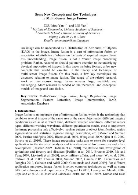
object’s appearance but also the object’s various physical attributes. Fig.1 shows<br />
three image samples. Fig.1 (a) is a multi-spectral image of somewhere, which shows<br />
more detailed geographical characteristics. Fig.1 (b) is its infrared image of the same<br />
area as that of the image in Fig.1 (a), which displays the temperature distribution of<br />
the area. Fig.1 (c) is a piece of a SAR image, in which there are a few airplanes. We<br />
cannot see any airplane clearly in Fig.1 (c). However the ultra-intensive reflection<br />
pattern appeared in the image shows the existence of the metal objects. Furthermore,<br />
the reflection pattern can offer useful information for confirming the structural<br />
characteristics of airplanes.<br />
4
(a) (b) (c)<br />
Fig.1 Three image samples. (a) A multispectral image. (b) An<br />
infrared image of the same area as that of the image in (a). (c) A<br />
piece of SAR image.<br />
In multi-spectral image processing, images at different wave b<strong>and</strong> <strong>and</strong> different<br />
polarization mode of the same vegetation area are usually different. In fact, such<br />
difference exhibits the property of the vegetation, i.e. it contains the feature<br />
attributes for distinguishing the property of the vegetation. In order to extract <strong>and</strong><br />
use these attributes, we should analyze every image <strong>and</strong> relate all attributes of all<br />
images together. But this by no means implies that we must ‘fuse’ these images<br />
together <strong>and</strong> form a single one. For such application, usually, it would be more<br />
desirable to create a few images or pseudo-colored geographic maps, each one of<br />
them exhibits a distribution of a special attribute of the vegetation area.<br />
(a)<br />
(b)<br />
Fig.2 <strong>Image</strong>s of the same metal bridge imaged by different polarization SAR.<br />
(a)VV Polarization SAR image;(b)HH Polarization SAR image<br />
Polarization SAR images are an important <strong>and</strong> typical example. The theory <strong>and</strong><br />
practice of backscattering of electromagnetic wave show that the reflection will<br />
enhance if the orientation of an edge of the object is coincident with the polarization<br />
5
direction of the electromagnetic wave. Especially, reflection will become much<br />
intensive if the length of the reflection edge is closer to the electromagnetic<br />
wavelength. If a SAR can work in HH, VV, or VH polarization modes, the acquired<br />
images in different modes will be different in general, even if the object has not any<br />
change. Fig.2 shows two images of the same metal bridge imaged by a SAR in<br />
different polarization modes. It can be seen that the lengths of the bridge in two<br />
images are quite different. This difference just reflects the metal attribute of the<br />
bridge. Imaging property caused by polarization has evident manifestations not only<br />
for metal objects but also for vegetations, soil <strong>and</strong> so on, although the manifestations<br />
may be different. It means that SAR images <strong>and</strong> even optical images obtained by<br />
various polarizations are different for different earth’s surface, i.e. these images<br />
contain the feature attributes of earth’s surface. These results of observation <strong>and</strong><br />
research have been widely used in agricultural monitoring, l<strong>and</strong> <strong>and</strong> resource<br />
surveying, disaster evaluation <strong>and</strong> statistics [Rignot, Camps-Valls 2008, Aanæs 2008,<br />
Unsalan 2009, Hedman et al. 2010].<br />
In conclusion of our observation, an image should be considered as a distribution<br />
of attributes of objects (DAO). A distribution (image) acquired from a sensor under<br />
a specified working mode describes certain particular attributes of the object.<br />
Different distributions (images) describe the object characteristics from different<br />
points of view, such as the visual appearance, material, the structure size <strong>and</strong><br />
orientation, temperature, the behavior of reflection, radiation <strong>and</strong> scattering, the<br />
foreground <strong>and</strong> the background associated with objects, etc. The task of image<br />
fusion is to utilize all information completely so as to realize information fusion.<br />
3. <strong>Key</strong> techniques involved in image fusion<br />
From the above observation, it can be seen that the research <strong>and</strong> application of<br />
image fusion depend on a mass of image materials coming from various imaging<br />
sensors. It is unlikely possible to provide reliable results using technical methods<br />
with absence of knowledge accumulation. Accompanied with image acquiring,<br />
analyzing <strong>and</strong> knowledge accumulation, the development of related theory <strong>and</strong><br />
techniques becomes indispensable.<br />
(1) <strong>Multi</strong>-sensor image registration<br />
<strong>Image</strong> registration based on the mutual correlation is suitable only to the case<br />
when two images to be aligned have the same gray feature. In medical image<br />
processing, in order to realize the registration operation between a CT<br />
(Computerized Tomography) image <strong>and</strong> an MRI (Magnetic Resonance Imaging)<br />
image, researches have developed a multi-modal image registration technique<br />
[Maintz 1998, Wong 2008]. The underlying theoretical basis is statistically<br />
computing the degree of coincidence of the variation of gray distributions of two<br />
images’ pixels. Such a degree of coincidence can be described by Kullback-Leibler<br />
divergence, mutual information, or mutual variance. <strong>Multi</strong>modal image registration<br />
can be used to process multi-sensor remote sensing image registration [Wang 2002,<br />
Shi 2004, Woo et al. 2009, Li et al. 2009]. However, the development of the related<br />
6
theory <strong>and</strong> technique remains expected.<br />
Inevitably, there are geometric distortions among multi-sensor remote sensing<br />
images, which make direct large-scale image registration non-practical. A technical<br />
method for the correction of geometric distortions is needed first. A typical<br />
geometric correction method is to determine two sets of feature points respectively<br />
in two images. The two sets of feature points are correctly corresponding to each<br />
other geometrically <strong>and</strong> they are used as reference points for geometric correction of<br />
one image to another. Traditional feature points are crossing points, corner points,<br />
etc. In practice, however, these points are difficult to be determined at pixel level for<br />
lack of a determinate criterion. In such a case, the correctness of selected feature<br />
points is not guaranteed. The concept of generalized feature points (GFD) [Zou 2002]<br />
provides more reasonable ground for determining the reference points of geometric<br />
correction.<br />
The primary idea of the GFD concept is as follows [Zou 2002]. Let A <strong>and</strong> B be<br />
two images to be registered. Select a small sub-image in A <strong>and</strong> it is denoted by SA1.<br />
The small image SA1 should be complicated enough, e.g. it contains crossing points,<br />
corners, endpoints, etc. We search for a small sub-image in B, denoted by SB1, so<br />
that SB1 <strong>and</strong> SA1 can be registered to each other exactly. This is possible by using<br />
the multimodal image registration technique. If this is realizable, an arbitrary point<br />
in SA1 has its counterpart in SB1, <strong>and</strong> such a pair can be used to serve as the feature<br />
points <strong>and</strong> called as the GFD. Typically, the centers of SA1 <strong>and</strong> SB1 can be selected<br />
as a pair of GFD. Similarly, we can select <strong>and</strong> determine more pairs of GFD in A<br />
<strong>and</strong> in B.<br />
For multi-sensor image fusion, we need not only to register/align the related<br />
images, but also to exhibit the different attributes of different images. This implies<br />
that, in certain areas of images, the patterns would be different from one image to the<br />
others. These different patterns cannot be registered each other. Rather, we must<br />
conserve these differences respectively. Clearly, we need such a registration<br />
technique that has the ability of distinguishing the object’s regions with non-object’s<br />
regions of images. Registration should be carried out only on the basis of<br />
non-object’s regions. In application, it is not really needed to determine the<br />
non-object’s regions exactly. In fact, for the aim of geometric correction we need<br />
only to determine three or more pairs of GFD located in the non-object’s regions.<br />
This is not a difficult task in usual case. However, detection of different patterns in<br />
different images by computer will be by no means an easy task for multi-model<br />
images. In fact, how to define “the different patterns” <strong>and</strong> distinguish it with other<br />
part of the image will be problematic. No exact theory <strong>and</strong> method have been<br />
reported in the literature.<br />
From the theory <strong>and</strong> experimental results of multi-modal image registration, we<br />
can see that the reported techniques in the literature suit for the situation that the<br />
geometric distribution of edges of the two images to be aligned is generally<br />
coincident while the gray attributes of corresponding regions of the images may be<br />
not consistent. For multi-sensor image registration application, these conditions may<br />
be difficult to be satisfied. Actually, in order to realize registration of Fig.1 (a) with<br />
7
Fig.1 (b), we need re-examine the existing theory <strong>and</strong> technique of multi-modal<br />
image registration because the lack of theory <strong>and</strong> method to verify <strong>and</strong> evaluate the<br />
precision of registration. Furthermore, it remains to be expected to investigate the<br />
registration problems for 3-D images <strong>and</strong> large size images formed from piecing<br />
together several images with distortion in geometry <strong>and</strong> in gray level. The h<strong>and</strong>ling<br />
of these problems would be challenging for researchers in this area.<br />
(2) Segmentation of the commonly interesting region<br />
On the basis of image registration, the second preprocessing step of<br />
implementation of image fusion is segmentation of the commonly interesting region<br />
in each related image. This work is naturally application-oriented. The interesting<br />
region may be the object itself. Also it may be the region containing the objects or<br />
the circumstance where objects are located. Segmentation of regions manually is not<br />
so realistic for massive image processing. In the literature, we can find a number of<br />
reports for image segmentation [Pham 2004, Artaechevarria et al. 2009, Wan et al.<br />
2009]. The most useful segmentation techniques can be established on the basis of<br />
the homogeneity of attributes in the region [Zou 2002]. The homogeneity generally<br />
used for image segmentation includes the homogeneity of gray level attribute; of<br />
statistical features of textures; of texture patterns; <strong>and</strong> of velocities of objects (for<br />
video image segmentation). A typical method is to compute the features of images in<br />
a specified small window. The features typically are: parameters of the probabilistic<br />
or deterministic image model, parameters of the images in the transform domain<br />
(Fourier Transform, DCT, Gabor Transform, Wavelet Transform, Curvelet<br />
Transform or <strong>Multi</strong>resolution Geometric Analysis, Singular Value Decomposition,<br />
Gray Histogram, etc.). These features can be directly used in image segmentation.<br />
However, a significant error of segmentation will appear in the neighborhood of the<br />
boundary of the region by this method. The active contour method has been<br />
successfully used for segmentation of images with homogeneity in gray level <strong>and</strong> it<br />
is very suitable to the task of segmentation <strong>and</strong> extraction of ocean coasts, lake<br />
surfaces, river channels <strong>and</strong> suchlike [Terzopoulious 1986, Kass et al. 1987]. There<br />
are lots of reports about image segmentation with large scale texture. But more<br />
general <strong>and</strong> efficient techniques are seeking yet [Zhang 2002, Yang 2004].<br />
Segmentation technique based on the feature homogeneity can only deal with<br />
very limited segmentation problems. <strong>Image</strong> fusion possibly requires more additional<br />
regional assignment techniques. For example, in order to evaluate the disaster, we<br />
need not only to determine the disaster-influenced region but also the potentially <strong>and</strong><br />
secondarily disaster-influenced areas. At the same time, we usually need to evaluate<br />
not only the capital disaster but the secondary disaster <strong>and</strong> the intergrowth disaster.<br />
When all of information should be exhibited on the basis of a complete set of images<br />
acquired from the past to the current, the image segmentation technique required for<br />
image fusion application will be in a composite form. In such a case, image<br />
segmentation <strong>and</strong> area partition need a data support from the large-area monitoring<br />
system. From the system framework of data fusion technique, such a level of<br />
inter-hierarchy fusion is short of investigation. Planning, controlling <strong>and</strong><br />
8
management of the urbanization process are important application of image fusion.<br />
It needs more detailed regional assignment <strong>and</strong> segmentation techniques to provide<br />
various statistics of information, such as constructing/constructed urban areas,<br />
planning regions, geography <strong>and</strong> geological distribution, <strong>and</strong> the dynamic process of<br />
urban evolution, etc. However, from the view point of image processing, how to<br />
define the segmentation region lacks of proper st<strong>and</strong>ard or criterion because the<br />
urban architecture usually forms irregular image patterns [Akçay 2007, 2008,<br />
Hedman et al. 2010].<br />
In practice of multi-sensor image fusion, the objects may exhibit divergent<br />
patterns <strong>and</strong> the boundaries of the objects versus its background may be not clearly<br />
distinguishable. This is the real case especially for radar <strong>and</strong> infrared images. In such<br />
a case, the conventional segmentation technique would produce a profile that may be<br />
different greatly from the real profile of the objects. A plausible way to avoid this<br />
difficulty is to produce a compact object’s region (COR) which satisfies a few<br />
conditions as follows. 1) The COR should be large enough that can contain the<br />
complete object’s pattern, visible <strong>and</strong> possibly invisible. 2) It is a common region for<br />
all acquired images from different sensors. 3) It is a compact (small enough) region<br />
that satisfies the conditions 1) <strong>and</strong> 2). To this end, the segmentation technique<br />
should be in a composite form that integrates several criteria <strong>and</strong> should be jointly<br />
carried out simultaneously to all images. The COR is an effective basis for<br />
extracting <strong>and</strong> describing the feature attributes of objects.<br />
(3) Extraction <strong>and</strong> association of feature attributes of objects<br />
<strong>Image</strong> processing for application of image fusion is asked to offer warranted<br />
information for the final image interpretation, <strong>and</strong> therefore extracting <strong>and</strong><br />
describing the feature attributes of objects become very important. The attributes of<br />
an image region generally mean the features of the texture of the region. We can<br />
extract various features of textures by means of mathematic modeling <strong>and</strong> transform<br />
techniques of images [Romdhani 2007]. Since an image is understood as a DAO, a<br />
basic problem should be investigated: what kind of feature attributes can fully reflect<br />
the physical property of a specified kind of objects <strong>and</strong> what kind of mathematic<br />
models is the most suitable for extracting the feature attributes. For example, the<br />
utilization of the polarization attributes has comprehensive significance. How to<br />
jointly process various texture features of polarized SAR images needs deeper<br />
theoretical study <strong>and</strong> experimental investigation.<br />
Extraction of objects from an image is a basic operation in image processing.<br />
Usually, a segmentation technique is required for extracting objects contained in an<br />
image. Typically, the profiles of objects are extracted. But this is not always feasible,<br />
when the boundary of the object is not distinguishable with the background. In<br />
military image fusion, a kind of particular artificial objects, such as airports, roads,<br />
large buckets, bridges, etc, are highly concerned [Mayer 1999, Akçay 2007, 2008].<br />
Usually, we cannot extract these objects directly from a large size image because in<br />
such a way we will waste too much computation resource. The grid searching<br />
scheme has the similar difficulty. At the first step, we can assign a particular object<br />
9
egion that contains the objects. This can be done on the basis of history knowledge<br />
obtained from remote sensing for most objects. For emerged unknown objects <strong>and</strong><br />
moving objects, such as airplanes, vehicles, tanks, warships, etc, a seeking algorithm<br />
would be needed. In any case, if a compact region that contains objects can be<br />
assigned before seeking, the computational burden of extraction operation will<br />
decrease drastically.<br />
In the development of the multimedia content description st<strong>and</strong>ard, MPEG7,<br />
researchers have proposed a series of technical methods for extracting <strong>and</strong><br />
describing the content in images [Manjunath 2002]. The research results for MPEG7<br />
inherently can be utilized as a good reference for researchers in our community.<br />
Take care that, however, implementation of image fusion requires much more<br />
precise results of extraction <strong>and</strong> description. A systemic research for the theory,<br />
method, <strong>and</strong> criteria remains in expectation.<br />
To describe regular artificial objects, such as airports, roads, large buckets,<br />
bridges, etc., there exist a number of methods that can be utilized singly or<br />
compositely. The mathematic transform methods (Fourier Transform, DCT, Gabor<br />
Transform, Wavelet Transform, Curvelet Transform or <strong>Multi</strong>-resolution Geometric<br />
Analysis, Singular Value Decomposition, Gray Histogram, etc.) are commonly used<br />
for extracting the numerical features of objects. Complex moments are a kind of<br />
numerical features with invariability. These features have been used successfully for<br />
pattern identification [Abu-Mostafa 1985, Jin <strong>and</strong> Davis 2005, Ruvimbo 2009].<br />
Hough transform is a feature extraction technique used for finding imperfect<br />
instances of objects within a certain class of shapes [Shapiro 2001]. The result of<br />
Hough transform can offer features of positions <strong>and</strong> arbitrary shapes including lines,<br />
squeres, circles or ellipses.<br />
Essentially, the description of an object by a set of numerical features implies a<br />
kind of simplified expresion of that object. A question is: what kind of description is<br />
the most efficient? The question closely relates to several important scientific<br />
problems such as data complexity, modeling, compression, <strong>and</strong> encoding. The<br />
research on this problem for images is highly expected.<br />
There is lack of general methods for describing movable objects, such as planes,<br />
vehicles, tanks, etc. These metal objects have strong reflecting points or reflecting<br />
lines accompanied by a particular reflection pattern in SAR images. Also they may<br />
have certain temperature distribution pattern in infrared images. Such a pattern will<br />
form a contrast with the background. Moreover, the movability of objects is a useful<br />
attribute. SAR will produce an imaging abnormality for moving objects. This<br />
implies a possibility of detecting moving objects. Furthermore, it is an effective<br />
method for images acquired at different time to obtain information of moving<br />
objects through moving detection. Care is needed that this method relies on the<br />
precision of image registration. The description method for attributes of moving<br />
metal objects now is not at h<strong>and</strong>. For SAR sensors, a possible method is to establish<br />
a database of reflection modes of various typical objects. Unluckily, the reflection<br />
patterns of SAR objects are greatly diverse. The reflection patterns depend on many<br />
factors, such as radar working frequency, transceiver polarization arrangement,<br />
10
object’s external structure, the spatial position <strong>and</strong> attitude of the object relative to<br />
the radar, etc. This makes the database of reflection patterns too large to be<br />
established. On the basis of reflection patterns, a possible way for establishing the<br />
radar object database is to find a set of numerical features with some invariability<br />
that can describe the reflection patterns. But it needs further theoretical <strong>and</strong><br />
experimental study.<br />
Association of feature attributes of objects has its special meaning for<br />
multi-sensor image fusion. The all attributes of an object obtained from all acquired<br />
multi-sensor images are associated to each other. This will offer a sound base for<br />
describing the objects so that the primary idea of image fusion can be implemented.<br />
To this end, an association database should be established. The association<br />
database proposed here is a database method which automatically associates the<br />
complete set of numerical features coming from different sensors relating to the<br />
same object or region. In the association database, a description may contain several<br />
terms. Each term consists of a few parameters that reflect the attributes of the object<br />
from all possible view angles. This is just the way of “blind men apperceive a big<br />
elephant”. For a special kind of objects, we should study <strong>and</strong> investigate the most<br />
essential features <strong>and</strong> the most suitable sensors. The database permits users to access,<br />
use <strong>and</strong> display each single image or combine all related images together flexibly,<br />
<strong>and</strong> to implement the synthesis <strong>and</strong> fusion algorithms conveniently. Such an<br />
association database must be application-oriented. For a specified application, a<br />
special data protocol, the object’s attribute-feature protocol (OAFP), should be<br />
established at the first step.<br />
Imaging a practical situation, if a few multi-sensor images of a same interesting<br />
area have been acquired, a primary question should be answered is that how to<br />
associate or relate the contents or objects of every image together? A general theory<br />
<strong>and</strong> method to answer this question would be very difficult to be made out. For a<br />
specified <strong>and</strong> a limited application, the model-based attribute association of objects<br />
is possible. For military image fusion application, for example, the objects to be<br />
concerned are limited. The available imaging apparatuses are also limited. Through a<br />
massive experiment investigation, the set of feature-attributes of objects under<br />
different imaging conditions can be established. Such a set can be viewed as a model<br />
for describing the object. This forms a basis for the model-based attribute<br />
association of objects <strong>and</strong> therefore the basis of the OAFP. Once such an OAFP is<br />
architected, it will offer a unified work frame in the research <strong>and</strong> application of<br />
image fusion.<br />
(4) Information fusion <strong>and</strong> automatic image interpretation<br />
This is the step of producing results of image fusion. On the basis of the<br />
established association database, the implementation of image fusion from the newly<br />
obtained images will become reasonable. The published information fusion theory<br />
<strong>and</strong> technique mainly concern the application of data fusion <strong>and</strong> fusion decision<br />
[Hall 2001]. The typical applications are concentrated to detection, tracking, <strong>and</strong><br />
identification of multiple moving targets; battlefield intelligence, surveillance, <strong>and</strong><br />
11
situation assessment; <strong>and</strong> integration <strong>and</strong> decision in Comm<strong>and</strong>-Control-<br />
Communication & Intelligence (C 3 I) systems; <strong>and</strong> a few non-military fields [Bar et<br />
al. 2010]. <strong>Image</strong> fusion has its extraordinary character which stems from the trait of<br />
images: richness <strong>and</strong> diversity of the content, <strong>and</strong> visibility <strong>and</strong> intuitiveness. In fact,<br />
the so-called “content” of an image may be divergently interpreted in usual case. In<br />
application, researchers must confine themselves to search for a specified set of<br />
attributes, each one of which can be described by a small set of numerical features.<br />
This would be realizable in virtue of the model-based attribute association of objects<br />
<strong>and</strong> the special data protocol OAFP mentioned previously.<br />
Automatic image interpretation is highly desirable for application. <strong>Image</strong><br />
interpretation closely relates to pattern recognition <strong>and</strong> image underst<strong>and</strong>ing. The<br />
research on these topics has got fruitful results in the recent several ten years. In the<br />
multi-sensor imaging circumstance, the input entries would be multiple. Once the<br />
operation of object association can be carried out on the basis of the OAFP, the<br />
development of the pattern recognition <strong>and</strong> image interpretation algorithms can be<br />
schemed on the br<strong>and</strong>-new basis. Since the objects we concerned can be described<br />
through multiple features, <strong>and</strong> each feature can be described by several numerical<br />
values, a weighted-composite feature-matching method would work well. The<br />
further advanced recognition <strong>and</strong> interpretation techniques may include [Dai <strong>and</strong><br />
Khorram 1999, Yun 2004, Dong et al. 2004, Huang <strong>and</strong> Jing 2007, Wang et al. 2007,<br />
Theodoridis, Koutroumbas 2009, Howson <strong>and</strong> Urbach 2005, Bolstad 2007, Carlin<br />
<strong>and</strong> Louis 2008, Bolstad 2010]:<br />
Hybrid numerical - morphological identification method<br />
Bayesian statistic based method<br />
Artificial neural network based identification method<br />
Mathematic manifold based identification method<br />
With the hybrid <strong>and</strong> composite inputs, the mentioned advanced methods <strong>and</strong> related<br />
theory should be re-examined. Nevertheless, the available data are now richer than<br />
ever, the correctness of object’s identification would be warranted with relative ease.<br />
When the result of image fusion is displayed in a dynamic video form or in the<br />
form of contrasted image series or geographic map series, the impact to our eye <strong>and</strong><br />
thought would be extraordinary. This implies that the mental factor <strong>and</strong> experience<br />
should be considered in fusion decision <strong>and</strong> image interpretation. In fact, a complete<br />
automatic image interpretation for practical scale images will ask a huge volume of<br />
computational resource. In practical circumstance, with the help of an experienced<br />
image interpreter, the man-machinery interactive image interpretation system would<br />
be much efficient. The interpreter can help to restrict the size of the concerned areas;<br />
to tag a part of intuitively discriminable objects; to correct some of errors in<br />
interpretation; <strong>and</strong> more. Clearly, in addition to the automatic image identification<br />
<strong>and</strong> fusion ability, a practical <strong>and</strong> efficient image fusion system should allow the<br />
control inputs from interpreters.<br />
4. Conclusions<br />
Since an image can be understood as a DAO, multi-sensor image fusion is<br />
12
naturally the matter of attribute composition or information fusion. With this view<br />
point, researchers must pay more attention to the physical implications of images. In<br />
the multi-sensor circumstance, the patterns of an identical object in different images<br />
may be significantly different from each other. The differences among patterns<br />
contain the feature attributes of the object. In this paper, a few preprocessing<br />
techniques, such as multi-sensor image registration, segmentation of the commonly<br />
interesting region, <strong>and</strong> extraction of feature attributes of objects, are discussed with<br />
considerations relating to image fusion. With the concept of the DAO, feature-level<br />
image fusion turns out to be association of attributes of objects. The natural<br />
reasoning of the consideration leads to the proposals for the association database <strong>and</strong><br />
the OAFP, which can be established on the basis of the model-based attribute<br />
association of objects. By means of the established association database, the<br />
implementation of image fusion from the newly obtained images will become<br />
reasonable.<br />
From the proposed concepts, the popular definition for image fusion, “The<br />
combination of two or more different images to form a new image by using a certain<br />
algorithm”, could not be the essential. “To form a new image” can be substituted by<br />
“to produce a set of associated attribute descriptions of objects”. The display <strong>and</strong> the<br />
related techniques are important, but not limited to a single fused image.<br />
The DAO is a new concept. It brings about a series of problems that should be<br />
considered in multi-sensor image fusion. In this paper, only a few commonly<br />
encountered problems have been mentioned. However, the range of the related<br />
research work is large, multifold, <strong>and</strong> challenging. The multi-sensor image fusion<br />
technique <strong>and</strong> the related theoretical concepts need continue efforts of many<br />
researchers.<br />
Notes on contributors<br />
Zou Mou-yan, Research Professor <strong>and</strong> retired from the Institute of Electronics,<br />
Chinese Academy of Science; Professor of the Graduate School, Chinese Academy<br />
of Science; Chief Executive Director of the Beijing TransMicrowave Technology<br />
Corp.. He has published more than 70 academic papers <strong>and</strong> is the author of the book<br />
“Deconvolution <strong>and</strong> Signal Recovery”. The recent research interests include image<br />
processing <strong>and</strong> commercial microwave radar techniques with application to the road<br />
traffic control <strong>and</strong> safety.<br />
Liu Yan, Lecturer of the Graduate School, Chinese Academy of Science. She<br />
Received her Doctoral Degree in 2007 from the Institute of Electronics, Chinese<br />
Academy of Science. The recent research interests include image processing <strong>and</strong><br />
video techniques with applications.<br />
References<br />
Aanæs, H., Sveinsson, J. R., <strong>and</strong> Nielsen, A. A. et al., 2008, Model-Based Satellite<br />
<strong>Image</strong> <strong>Fusion</strong>, IEEE Transactions on Geoscience <strong>and</strong> Remote Sensing, 46(5),<br />
1336-1346.<br />
13
Abu-Mostafa, Y. <strong>and</strong> Psaltis, D., 1985, <strong>Image</strong> normalization by complex moments.<br />
IEEE Trans Pattern Analysis Machine Intelligence, PAMI-7:46–55.<br />
Akçay, H. G. <strong>and</strong> Aksoy, S., 2008, Automatic Detection of Geospatial Objects<br />
Using <strong>Multi</strong>ple Hierarchical Segmentations, IEEE Transactions on<br />
Geoscience <strong>and</strong> Remote Sensing, 46(7),2097-2111.<br />
Akçay, H. G. <strong>and</strong> Aksoy, S., 2007,Automated Detection of Objects Using <strong>Multi</strong>ple<br />
Hierarchical Segmentations, Proc. of IEEE International Geoscience <strong>and</strong><br />
Remote Sensing Symposium (IGARSS’07) 1468-1471.<br />
Artaechevarria X., Munoz-Barrutia A., Ortiz-de-Solorzano C., 2009, Combination<br />
Strategies in <strong>Multi</strong>-Atlas <strong>Image</strong> Segmentation: Application to Brain MR Data,<br />
IEEE Transactions on Medical Imaging, 28(8), 1266-1277.<br />
Bai Ying-Wen, Shen Li-Sih, Li Zong-Han, 2010, Design <strong>and</strong> implementation of an<br />
embedded home surveillance system by use of multiple ultrasonic sensors,<br />
IEEE Transactions on Consumer Electronics, 56(1), 119-124.<br />
Bar D.E., Wolowelsky K., Swirski Y.,et al., 2010, Target Detection <strong>and</strong> Verification<br />
via Airborne Hyperspectral <strong>and</strong> High-Resolution <strong>Image</strong>ry Processing <strong>and</strong><br />
<strong>Fusion</strong>, IEEE <strong>Sensor</strong>s Journal,10(3), 707-711.<br />
Blum, R.S.; Liu, Z. 2006, <strong>Multi</strong>-<strong>Sensor</strong> <strong>Image</strong> <strong>Fusion</strong> <strong>and</strong> Its Applications; special<br />
series on Signal Processing <strong>and</strong> Communications; CRC Press: Boca Raton,<br />
FL, USA.<br />
Bolstad, William M., 2007, Introduction to Bayesian Statistics: Second Edition, John<br />
Wiley.<br />
Bolstad, William M. (2010) Underst<strong>and</strong>ing Computational Bayesian Statistics, John<br />
Wiley.<br />
Bovolo F., Bruzzone L., Capobianco L., et al., 2010, Analysis of the Effects of<br />
Pansharpening in Change Detection on VHR <strong>Image</strong>s, IEEE Geoscience <strong>and</strong><br />
Remote Sensing Letters, 7(1), 53-57.<br />
Brunner D., Lemoine G., Bruzzone L., 2010, Earthquake Damage Assessment of<br />
Buildings Using VHR Optical <strong>and</strong> SAR <strong>Image</strong>ry, IEEE Transactions on<br />
Geoscience <strong>and</strong> Remote Sensing, 48(5), 2403-2420.<br />
Calhoun V.D., Adali T., 2009, Feature-Based <strong>Fusion</strong> of Medical Imaging Data, IEEE<br />
Transactions on Information Technology in Biomedicine, 13(5), 711-720.<br />
Camps-Valls, G. Gómez-Chova, L. <strong>and</strong> Muñoz-Marí, J. et al., 2008, Kernel-Based<br />
Framework for <strong>Multi</strong>temporal <strong>and</strong> <strong>Multi</strong>source Remote Sensing Data<br />
Classification <strong>and</strong> Change Detection, IEEE Transactions on Geoscience <strong>and</strong><br />
Remote Sensing, 46(6),1822-1835.<br />
Carlin, Bradley P. <strong>and</strong> Louis, Thomas A. (2008). Bayesian Methods for Data<br />
Analysis, Third Edition. Boca Raton, FL: Chapman <strong>and</strong> Hall/CRC.<br />
Cartmill J., Wachowski N., Azimi-Sadjadi M.R., 2009, Buried Underwater Object<br />
Classification Using a Collaborative <strong>Multi</strong>aspect Classifier, IEEE Journal of<br />
Oceanic Engineering, 34(1), 32-44.<br />
Celik T., Ma Kai-Kuang, 2010, Unsupervised Change Detection for Satellite <strong>Image</strong>s<br />
Using Dual-Tree Complex Wavelet Transform, IEEE Transactions on<br />
Geoscience <strong>and</strong> Remote Sensing, 48(3), 1199-1210.<br />
14
Chen Shaohui, Zhang Renhua, Su Hongbo, et al, 2010, SAR <strong>and</strong> <strong>Multi</strong>spectral<br />
<strong>Image</strong> <strong>Fusion</strong> Using Generalized IHS Transform Based on à Trous Wavelet<br />
<strong>and</strong> EMD Decompositions, IEEE <strong>Sensor</strong>s Journal, 10(3), 737-745.<br />
Copel<strong>and</strong> A. D., Mangoubi R. S., Desai M. N., et al., 2010, Spatio-Temporal Data<br />
<strong>Fusion</strong> for 3D+T <strong>Image</strong> Reconstruction in Cerebral Angiography, IEEE<br />
Transactions on Medical Imaging, 29(6), 1238-1251.<br />
Correa Nicolle M., Adali Tulay, Li, Yi-Ou, et al., 2010,Canonical Correlation<br />
Analysis for Data <strong>Fusion</strong> <strong>and</strong> Group Inferences, IEEE Signal Processing<br />
Magazine, 27(4), 39-50.<br />
Cvejic N., Seppanen T., Godsill S.J., 2009, A Nonreference <strong>Image</strong> <strong>Fusion</strong> Metric<br />
Based on the Regional Importance Measure, IEEE Journal of Selected Topics<br />
in Signal Processing, 3(2), 212-221.<br />
Dai, X.; Khorram, S. Data fusion using artificial neural networks: a case study on<br />
multitemporal change analysis. Comput. Environ. Urban Syst. 1999, 23,<br />
19–31.<br />
Dong. J.; Yang, X.; Clinton, N.; Wang, N. 2004, An artificial neural network model<br />
for estimating crop yields using remotely sensed information. Int. J. Remote<br />
Sens., 25, 1723–1732.<br />
Dong Jiang, Zhuang Dafang, Huang Yaohuan <strong>and</strong> Fu Jingying,2009,Advances in<br />
<strong>Multi</strong>-<strong>Sensor</strong> Data <strong>Fusion</strong>: Algorithms <strong>and</strong> Applications , <strong>Sensor</strong>s, 9,<br />
7771-7784.<br />
Flusser, Jan. Sroubek, F. Zitova, B., 2007,<strong>Image</strong> <strong>Fusion</strong> Principles Methods <strong>and</strong><br />
Applications, Tutorial of the 15th European Signal Processing Conference<br />
(EUSIPCO’2007).<br />
Gamba, P. Hellwich, O. <strong>and</strong> Lombardo, P. 2005,<strong>Fusion</strong> of Remotely Sensed Data<br />
Over Urban Areas, Information <strong>Fusion</strong>, (6),189-192.<br />
Goshtasby, A. A. <strong>and</strong> Nikolov, S., 2007,<strong>Image</strong> fusion: Advances in The State of<br />
The Art, Information <strong>Fusion</strong>, (8),114-118.<br />
Gundimada S., Asari V.K., 2009, Facial Recognition Using <strong>Multi</strong>sensor <strong>Image</strong>s<br />
Based on Localized Kernel Eigen Spaces, IEEE Transactions on <strong>Image</strong><br />
Processing, 18(6), 1314-1312.<br />
Hall, D.L. <strong>and</strong> Llinas, J., 1997, An Introduction to <strong>Multi</strong>sensor Data <strong>Fusion</strong>, Proc.<br />
IEEE, 85 (1),6–23.<br />
Hall, D. L. <strong>and</strong> Llinas, J., ed., 2001, H<strong>and</strong>book of multisensor data fusion, CRC<br />
Press, New York.<br />
Hedman K., Stilla U., Lisini G., et al., 2010, Road Network Extraction in VHR SAR<br />
<strong>Image</strong>s of Urban <strong>and</strong> Suburban Areas by Means of Class-Aided Feature-Level<br />
<strong>Fusion</strong>, IEEE Transactions on Geoscience <strong>and</strong> Remote Sensing, 48(3),<br />
1294-1296.<br />
Hizem W., Allano L., Mellakh A., et al., 2009,Face recognition from synchronised<br />
visible <strong>and</strong> near-infrared images, IET Signal Processing, 3(4), 282-288.<br />
Howson, Colin <strong>and</strong> Urbach, Peter, 2005, Scientific Reasoning: the Bayesian<br />
Approach (3rd ed.). Open Court Publishing Company.<br />
Huang, W.; Jing, Z. <strong>Multi</strong>-focus image fusion using pulse coupled neural network.<br />
15
Pattern Recognit. Lett. 2007, 28, 1123–1132.<br />
Jeffrey K. A., Otto L. L., Kozioziemski, Bernard J., et al., 2009,<br />
Refraction-enhanced x-ray radiography for inertial confinement fusion <strong>and</strong><br />
laser-produced plasma applications, Journal of Applied Physics, 105(11),<br />
113112-113112-8.<br />
Jin, X.Y.; Davis, C.H. An integrated system for automatic road mapping from<br />
high-resolution multi-spectral satellite imagery by information fusion. Inf.<br />
<strong>Fusion</strong> 2005, 6, 257–273.<br />
Joshi M., Jalobeanu A., 2010, MAP Estimation for <strong>Multi</strong>resolution <strong>Fusion</strong> in<br />
Remotely Sensed <strong>Image</strong>s Using an IGMRF Prior Model, IEEE Transactions<br />
on Geoscience <strong>and</strong> Remote Sensing, 48(3), 1245-1255.<br />
Jun S., Xiaoling Z., Jianyu Y., et al., 2009, Radix- Resolution-<strong>Fusion</strong> for LASAR via<br />
Orthogonal Complement Decomposition, IEEE Geoscience <strong>and</strong> Remote<br />
Sensing Letters, 6(1) , 147-151.<br />
Kalka N.D.; Jinyu Zuo, Schmid N.A.,et al., 2010, Estimating <strong>and</strong> Fusing Quality<br />
Factors for Iris Biometric <strong>Image</strong>s, IEEE Transactions on Systems, Man <strong>and</strong><br />
Cybernetics, Part A: Systems <strong>and</strong> Humans, 40(3), 509-524.<br />
Karantzalos K., Paragios N., 2010, Large-Scale Building Reconstruction Through<br />
Information <strong>Fusion</strong> <strong>and</strong> 3-D Priors, IEEE Transactions on Geoscience <strong>and</strong><br />
Remote Sensing,48(5), 2283-2296.<br />
Kass M., Witkin A., Terzopoulos D., 1987, Snakes: Active Contour Models,<br />
International Journal Comp. Vis., 1(4):321-331.<br />
Kumar M. , Dass S., 2009, A Total Variation-Based Algorithm for Pixel-Level <strong>Image</strong><br />
<strong>Fusion</strong>, IEEE Transactions on <strong>Image</strong> Processing, 18(9), 2137-2143.<br />
Kumar, R. An<strong>and</strong>an, P. Irani, M., etc., 1995,Representation of Scenes from<br />
Collections of <strong>Image</strong>s, Proc. of IEEE Workshop on Representations of Visual<br />
Scenes, 10-17.<br />
Li Zhenhua, Leung H., 2009, <strong>Fusion</strong> of <strong>Multi</strong>spectral <strong>and</strong> Panchromatic <strong>Image</strong>s<br />
Using a Restoration-Based Method, IEEE Transactions on Geoscience <strong>and</strong><br />
Remote Sensing, 47(5) , 1482-1491.<br />
Li Qiaoliang, Wang Guoyou, Liu Jianguo, et al., 2009, Robust Scale-Invariant<br />
Feature Matching for Remote Sensing <strong>Image</strong> Registration, IEEE Geoscience<br />
<strong>and</strong> Remote Sensing Letters, 6(2), 287-291.<br />
Licciardi G., Pacifici F., Tuia D., et al., 2009, Decision <strong>Fusion</strong> for the Classification<br />
of Hyperspectral Data: Outcome of the 2008 GRS-S Data <strong>Fusion</strong> Contest,<br />
IEEE Transactions on Geoscience <strong>and</strong> Remote Sensing, 47(11), 3857-3865.<br />
Looney D., M<strong>and</strong>ic D.P., 2009, <strong>Multi</strong>scale <strong>Image</strong> <strong>Fusion</strong> Using Complex Extensions<br />
of EMD, IEEE Transactions on Signal Processing, 57(4), 1626-1630.<br />
Ma Hongchao, Yang Yun, 2009, Two Specific <strong>Multi</strong>ple-Level-Set Models for<br />
High-Resolution Remote-Sensing <strong>Image</strong> Classification, IEEE Geoscience <strong>and</strong><br />
Remote Sensing Letters, 6(3), 558-561.<br />
Masini A., Corsini G., Diani M., et al., 2009, Analysis of <strong>Multi</strong>resolution-Based<br />
<strong>Fusion</strong> Strategies for a Dual Infrared System, IEEE Transactions on<br />
Intelligent Transportation Systems , 10(4), 688-694.<br />
16
Maintz, J.B.A., Viergever, M.A., 1998, A Survey of Medical <strong>Image</strong> Registration,<br />
Medical <strong>Image</strong> Analysis, 2(1),1–36.<br />
Manjunath, B.S., Salembier, P. <strong>and</strong> Sikora, T. Ed., 2002, Introduction to MPEG-7:<br />
<strong>Multi</strong>media Content Description Interface. Wiley & Sons.<br />
Molch K., 2010, <strong>Multi</strong>sensor <strong>and</strong> <strong>Multi</strong>temporal <strong>Fusion</strong> of VHR Satellite <strong>Image</strong>ry<br />
Based on KIM, IEEE Geoscience <strong>and</strong> Remote Sensing Letters, 7(1), 48-52.<br />
Monwar M.M.; Gavrilova M.L., 2009, <strong>Multi</strong>modal Biometric System Using<br />
Rank-Level <strong>Fusion</strong> Approach, IEEE Transactions on Systems, Man, <strong>and</strong><br />
Cybernetics, Part B: Cybernetics, 39(4), 867-878.<br />
Moser G., Serpico S.B., 2009,Unsupervised Change Detection From <strong>Multi</strong>channel<br />
SAR Data by Markovian Data <strong>Fusion</strong>, IEEE Transactions on Geoscience <strong>and</strong><br />
Remote Sensing, 47(7), 2114-2128.<br />
Orchard J., Mann R., 2010,Registering a <strong>Multi</strong><strong>Sensor</strong> Ensemble of <strong>Image</strong>s, IEEE<br />
Transactions on <strong>Image</strong> Processing, 19(5), 1236-1247.<br />
Pham D.L., Xu Chenyang, <strong>and</strong> Prince J.L. 2004, A survey of current methods in<br />
medical image segmentation.<br />
http://www.rfai.li.univ-tour.fr/rousselle/docum/pdf/p124r.pdf.<br />
Pastina D., Spina C., 2009, <strong>Multi</strong>-feature based automatic recognition of ship targets<br />
in ISAR, IET Radar, Sonar & Navigation, 3(4),406-423.<br />
Petillot I., Trouve E., Bolon P.,et al., 2010, Radar-Coding <strong>and</strong> Geocoding Lookup<br />
Tables for the <strong>Fusion</strong> of GIS <strong>and</strong> SAR Data in Mountain Areas, IEEE<br />
Geoscience <strong>and</strong> Remote Sensing Letters,7(2), 309-313.<br />
Poh N., Kittler J., Bourlai T., 2010, Quality-Based Score Normalization With Device<br />
Qualitative Information for <strong>Multi</strong>modal Biometric <strong>Fusion</strong>, IEEE Transactions<br />
on Systems, Man <strong>and</strong> Cybernetics, Part A: Systems <strong>and</strong> Humans, 40(30),<br />
539-554.<br />
Pohl, C., Genderen, J. L., 1998, <strong>Multi</strong>sensor <strong>Image</strong> <strong>Fusion</strong> in Remote Sensing:<br />
Concepts, Methods <strong>and</strong> Applications, International Journal of Remote<br />
Sensing, 9(5),823-854.<br />
Qian M. , Aguilar M., Zachery K.N., et al., 2009, Decision-Level <strong>Fusion</strong> of EEG<br />
<strong>and</strong> Pupil Features for Single-Trial Visual Detection Analysis, IEEE<br />
Transactions on Biomedical Engineering, 56(7), 1929-1937.<br />
Rignot, E. <strong>and</strong> Chellappa, R., Segmentation of Polarimetric Synthetic Aperture<br />
Radar Data, IEEE Trans. on <strong>Image</strong> Processing, 1(3),281 – 300.<br />
Romdhani, S. <strong>and</strong> Vetter, T., 2007, 3D Probabilistic Feature Point Model for Object<br />
Detection <strong>and</strong> Recognition, Proc. of IEEE Conference on Computer Vision<br />
<strong>and</strong> Pattern Recognition (CVPR '07) 1-8.<br />
Ruvimbo, G.; Philippe, D.; Morgan, D. 2009, Object-oriented change detection for<br />
the city of Harare, Zimbabwe. Exp. Syst. Appl. 36, 571–588.<br />
Shah V.P., Younan N.H., Durbha S.S., et al., 2010, Feature Identification via a<br />
Combined ICA–Wavelet Method for <strong>Image</strong> Information Mining, IEEE<br />
Geoscience <strong>and</strong> Remote Sensing Letters, 7(1), 18-22.<br />
Shapiro, L. <strong>and</strong> Stockman, G., 2001, Computer Vision, Prentice-Hall, Inc..<br />
Shi Yonggang, 2004,Research of Generalized Distance Measure <strong>and</strong> <strong>Multi</strong>-modal<br />
17
<strong>Image</strong> Registration, PhD Thesis, Institute of Electronics, Chinese Academy of<br />
Sciences (in Chinese).<br />
Simone, G. Farina, A. <strong>and</strong> Morabito, F.C. et al., 2002,<strong>Image</strong> <strong>Fusion</strong> <strong>Techniques</strong> for<br />
Remote Sensing Applications, Information <strong>Fusion</strong>, (3),3-15.<br />
Smith, M.I.; Heather, J.P. 2005, Review of image fusion technology in 2005. In<br />
Proceedings of Defense <strong>and</strong> Security Symposium, Orl<strong>and</strong>o, FL, USA.<br />
Terzopoulios D., 1986, On matching deformable models to images, Technical Report<br />
60, Schlumberger Palo Alto Research,<br />
Theodoridis, Sergios, Koutroumbas, Konstantinos, 2009, "Pattern Recognition", 4th<br />
Edition, Academic Press, ISBN: 978-1-59749-272-0.<br />
Thomas, C., Ranchin, T., <strong>and</strong> Wald, L.,et al., 2008, Synthesis of <strong>Multi</strong>spectral<br />
<strong>Image</strong>s to High Spatial Resolution: A Critical Review of <strong>Fusion</strong> Methods<br />
Based on Remote Sensing Physics, IEEE Transactions on Geoscience <strong>and</strong><br />
Remote Sensing, 46(5),1301-1312.<br />
Udelhoven T., van der Linden S., Waske B. , et al., 2009, Hypertemporal<br />
Classification of Large Areas Using Decision <strong>Fusion</strong>, IEEE Geoscience <strong>and</strong><br />
Remote Sensing Letters, 6(3),592-596.<br />
Unsalan C., 2009, Statistical, Structural, Hybrid, <strong>and</strong> Graph Theoretical Features to<br />
Measure L<strong>and</strong> Development, IEEE Geoscience <strong>and</strong> Remote Sensing Letters,<br />
6(1), 72-76.<br />
Vijayaraj, V.; Younan, N.; O‟Hara, C. Concepts of image fusion in remote sensing<br />
applications. In Proceedings of IEEE International Conference on Geoscience<br />
<strong>and</strong> Remote Sensing Symposium, Denver, CO, USA, July 31–August 4, 2006;<br />
pp. 3798–3801.<br />
Wan Tao, Canagarajah N., Achim, A., 2009, Segmentation-Driven <strong>Image</strong> <strong>Fusion</strong><br />
Based on Alpha-Stable Modeling of Wavelet Coefficients, IEEE Transactions<br />
on <strong>Multi</strong>media,1 1(4), 624-633.<br />
Wang Dongfeng, 2002,A Study on Registration of <strong>Multi</strong>modal <strong>and</strong> Huge-size<br />
images, PhD Thesis, Institute of Electronics, Chinese Academy of Sciences<br />
(in Chinese).<br />
Wang, R.; Bu, F.L.; Jin, H.; Li, L.H. 2007, A feature-level image fusion algorithm<br />
based on neural networks. Bioinf. Biomed. Eng., 7, 821–824.<br />
Wang Z.F., Han Q., Li Q., et al., 2009, Complex common vector for multimodal<br />
biometric recognition, Electronics Letters, 45(10),495-496.<br />
Wong, A. <strong>and</strong> Bishop, W., 2008,Efficient Least Squares <strong>Fusion</strong> of MRI <strong>and</strong> CT<br />
<strong>Image</strong>s Using A Phase Congruency Model, Pattern Recognition, (29),<br />
173–180.<br />
Woo Sang-Keun, Kim Kyeong Min, Lee Tae Sup, et al., 2009, Registration Method<br />
for the Detection of Tumors in Lung <strong>and</strong> Liver Using <strong>Multi</strong>modal Small<br />
Animal Imaging, IEEE Transactions on Nuclear Science, 56(3), 1454-1458.<br />
Wu Shunguang, Decker S., Chang Peng, et al., 2009,Collision Sensing by Stereo<br />
Vision <strong>and</strong> Radar <strong>Sensor</strong> <strong>Fusion</strong>, IEEE Transactions on Intelligent<br />
Transportation Systems, 10(4), 606-614.<br />
Xie Shufu, Shan Shiguang, Chen Xilin, et al., 2010, Fusing Local Patterns of Gabor<br />
18
Magnitude <strong>and</strong> Phase for Face Recognition, IEEE Transactions on <strong>Image</strong><br />
Processing, 19(5), 1349-1361.<br />
Yang Bin, Shutao Li, 2010, <strong>Multi</strong>focus <strong>Image</strong> <strong>Fusion</strong> <strong>and</strong> Restoration With Sparse<br />
Representation, IEEE Transactions on Instrumentation <strong>and</strong> Measurement,<br />
59(4),884-892.<br />
Yang Hongbo, 2004,Research of Unsupervised Texture Segmentation, PhD Thesis,<br />
Institute of Electronics, Chinese Academy of Sciences (in Chinese).<br />
Yun, Z. 2004, Underst<strong>and</strong>ing image fusion. Photogram. Eng. Remote Sens., 6,<br />
657–661.<br />
Zhang Fan, Wu Xiaolin, Yang Xiaokang, et al., 2009, Robust Color Demosaicking<br />
With Adaptation to Varying Spectral Correlations, IEEE Transactions on<br />
<strong>Image</strong> Processing, 18(12),2706-2717.<br />
Zhang Yifan, De Backer S., Scheunders P., 2009, Noise-Resistant Wavelet-Based<br />
Bayesian <strong>Fusion</strong> of <strong>Multi</strong>spectral <strong>and</strong> Hyperspectral <strong>Image</strong>s, IEEE<br />
Transactions on Geoscience <strong>and</strong> Remote Sensing, 47(11) , 3834-3843.<br />
Zhang Lifei, 2002,Active Contour Technique Based on Minimum Description<br />
Length Principle, PhD Thesis, Institute of Electronics, Chinese Academy of<br />
Sciences (in Chinese).<br />
Zou Mouyan, Wang Dongfeng, Zhang Lifei, 2002,“The Evolution <strong>and</strong> <strong>Key</strong><br />
Problems of Remote Sensing <strong>Image</strong> Segmentation <strong>and</strong> Registration<br />
<strong>Techniques</strong>”, Proc. of the eighth Symposium on the Remote Sensing,<br />
Telemetry <strong>and</strong> Remote Control (in Chinese).<br />
Zou Mouyan <strong>and</strong> Liu Yan, 2009, “<strong>Multi</strong>-<strong>Sensor</strong> <strong>Image</strong> <strong>Fusion</strong>: <strong>Difficulties</strong> <strong>and</strong> <strong>Key</strong><br />
<strong>Techniques</strong>”, Proc. of the 2 nd International Congress on <strong>Image</strong> <strong>and</strong> Signal<br />
Processing, CISP’09, Oct, TianJin, China.<br />
19