Saturnino A. Pacubas - USAid
Saturnino A. Pacubas - USAid
Saturnino A. Pacubas - USAid
You also want an ePaper? Increase the reach of your titles
YUMPU automatically turns print PDFs into web optimized ePapers that Google loves.
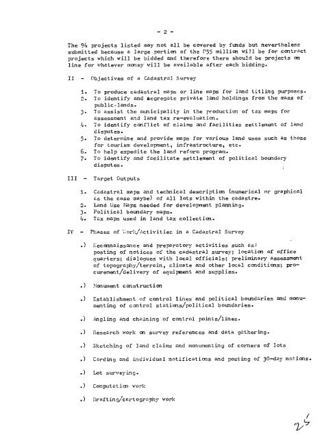
- 2 -<br />
The 94 projects listed may not all be covered by funds but nevertheless<br />
submitted because a large portion of the P55 million will be for contract<br />
projects which will be bidded and therefore there should be projects on<br />
line for whatever money will be available after each bidding.<br />
II - Objectives of a Cadastral Survey<br />
1. To produce cadastral maps or line maps for land titling purposes.<br />
2. To identify and aegregate private land holdings from the mass of<br />
public.lands.<br />
3. To assist the municipality in the production of tax maps for<br />
assessment and land tax re-evaluation.<br />
4. To identify conflict of claims and facilities settlement of land<br />
disputes.<br />
5. To determine and provide maps for various land uses such as those<br />
for tourism development, infrastructure, etc.<br />
6. To help expedite the land reform program.<br />
7. To identify and facilitate settlement of political boundary<br />
disputes.<br />
III - Target Outputs<br />
1. Cadastral maps and technical description (numerical or graphical<br />
as the case maybe) of all lots within the cadastre.<br />
2. Land Use I-aps needed for development planning.<br />
3- Political boundary maps.<br />
4. Tax maps used in land tax collection.<br />
IV - Phases of L'or%/Activitien in a Cadastral Survey<br />
.) ieconnaissance and preparatory activities such as:<br />
posting of notices of the cadastral survey; location of office<br />
quarters; dialogues with local officials; preliminary assessment<br />
of topography/terrain, climate and other local conditions; procurement/delivery<br />
of equipment and supplies.<br />
.) ilonunent construction<br />
.) Establishment of control lines and political boundaries and monumenting<br />
of control stations/political boundaries.<br />
.) Angling and chaining of control points/lines.<br />
.) Research work on survey references and data gathering.<br />
.) Sketching of land claims and monumenting of corners of lots<br />
.) Carding and individual notifications and posting of 30-day notions.<br />
.) Lot surveying.<br />
.) Computatio-n work<br />
.) Draftin gj/cart ography work<br />
/


