The Urban archeTypes projecT Community Case Study: The City of ...
The Urban archeTypes projecT Community Case Study: The City of ...
The Urban archeTypes projecT Community Case Study: The City of ...

You also want an ePaper? Increase the reach of your titles
YUMPU automatically turns print PDFs into web optimized ePapers that Google loves.
CANMET Energy Technology Centre<br />
CLEAN ENERGY TECHNOLOGIES<br />
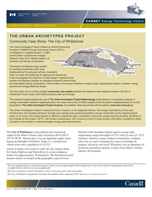
<strong>The</strong> <strong>Urban</strong> Archetypes Project<br />
<strong>Community</strong> <strong>Case</strong> <strong>Study</strong>: <strong>The</strong> <strong>City</strong> <strong>of</strong> Whitehorse<br />
<strong>The</strong> <strong>Urban</strong> Archetypes Project initiated by Natural Resources<br />
Canada’s CANMET Energy Technology Centre (CETC),<br />
investigated 31 neighbourhoods 1 in eight<br />
communities 2 to explore the linkages<br />
between urban form, lifestyle patterns <strong>of</strong><br />
residents and energy consumption.<br />
<strong>The</strong> project developed energy pr<strong>of</strong>iles<br />
for average households within each<br />
neighbourhood for personal vehicles, household<br />
heat, hot water and electricity for lighting and appliances.<br />
It also investigated the influence <strong>of</strong> urban design, neighbourhood<br />
location and lifestyle variables on average household vehicle travel<br />
and associated energy consumption. Communities in the project reflected a range <strong>of</strong> sizes, geographical regions, climates, energy<br />
sources and energy efficiency issues.<br />
This fact sheet, one in a series <strong>of</strong> eight community case studies presents the results for three neighbourhoods in the <strong>City</strong> <strong>of</strong><br />
Whitehorse: Porter Creek; Wolf Creek and Mary Lake; and Granger.<br />
This research project explored the use <strong>of</strong> <strong>The</strong> <strong>Urban</strong> Archetypes Project Methodology which allows for comparative analysis <strong>of</strong><br />
energy consumption between neighbourhoods in the same community. A further analysis <strong>of</strong> all the project’s neighbourhoods (31) will be<br />
presented in <strong>The</strong> <strong>Urban</strong> Archetypes Project Analysis. As available, these documents will be posted to www.sbc.nrcan.gc.ca.<br />
<strong>The</strong> <strong>Urban</strong> Archetypes Project is among the first to explore, in an integrated fashion, the energy implications <strong>of</strong> land use,<br />
infrastructure and building decisions through case studies that present quantitative energy information at the neighbourhood<br />
scale. In so doing, this project begins to address a significant gap in Canadian community energy planning practice. Building on<br />
the findings <strong>of</strong> this project, CETC, with project collaborators, will continue to work to make energy information available to assist<br />
Canadian communities in making strategic energy planning decisions.<br />
<strong>The</strong> <strong>City</strong> <strong>of</strong> Whitehorse is the political and commercial<br />
capital <strong>of</strong> the Yukon Territory and is located at 60°43’00”N<br />
135°03’00”W. Historically, it was an important supply centre<br />
during the Klondike Gold Rush. Today, it’s a modern and<br />
vibrant town with a population <strong>of</strong> 24,151 3 .<br />
Linear in nature, from north to south, the city extends along<br />
the Alaska Highway and Yukon River in a non-contiguous<br />
fashion for approximately 30 kilometres. <strong>The</strong> downtown/central<br />
business district is located in the geographic centre <strong>of</strong> town.<br />
Situated in the mountain climate region, average daily<br />
temperatures range from highs <strong>of</strong> 21°C (July) to lows <strong>of</strong> −22°C<br />
(January). Similar to many northern communities, residents<br />
<strong>of</strong>ten rely on a mix <strong>of</strong> heating fuel sources including oil,<br />
propane, electricity and wood. Whitehorse has an abundance <strong>of</strong><br />
electricity generation capacity; a legacy from Yukon’s mining<br />
industry development.<br />
1 <br />
<strong>The</strong> term neighbourhood, as used in this project, denotes an area approximately 300 dwelling units in size and <strong>of</strong> relatively homogenous urban form;<br />
a neighbourhood could vary in size geographically.<br />
2<br />
<strong>The</strong> term community, as used in this project, refers to the same scale as the municipality.<br />
3 <br />
<strong>The</strong> <strong>City</strong> <strong>of</strong> Whitehorse Integrated <strong>Community</strong> Sustainability Plan. September 2007. http://www.city.whitehorse.yk.ca<br />
Cat. N o .: M154-15/2008E-PDF ISBN: 978-1-100-10283-2
<strong>Urban</strong> Archetypes Project Whitehorse YK<br />
CANMET Energy Technology Centre<br />
NEIGHBOURHOOD DESCRIPTIONS<br />
Porter Creek<br />
Porter Creek is situated on the upper bench <strong>of</strong> the Yukon<br />
River Valley, approximately 6 km from downtown Whitehorse.<br />
Built in the late 1970s and early 1980s, dwellings are almost<br />
exclusively single detached although some contain legal<br />
secondary suites.<br />
<strong>The</strong> neighbourhood was developed according to a grid pattern<br />
<strong>of</strong> streets and avenues complete with sidewalks, streetlights,<br />
and cross-walks; houses are set back from the street allowing<br />
for manicured front yards and a suburban appearance. While<br />
there are no commercial operations within the study area, a<br />
few commercial businesses are found on Centennial Street.<br />
A school, a church, and art theatre are also located nearby.<br />
Residents <strong>of</strong> this area have access to a local park and outdoor<br />
rink. <strong>The</strong>re are many recreational trails throughout the<br />
neighbourhood.<br />
Wolf Creek & Mary Lake<br />
Wolf Creek and Mary Lake 4 are country residential<br />
subdivisions <strong>of</strong> large lots located approximately 15 km south <strong>of</strong><br />
downtown Whitehorse on the Alaska Highway. While the first<br />
homes were built in the late 1970s, redevelopment continues<br />
to take place. <strong>The</strong> majority <strong>of</strong> residences are single-detached<br />
dwellings interspersed with a few mobile homes.<br />
Homes are generally set back from the road, giving the<br />
neighbourhood a rural appearance. <strong>The</strong> road network pattern<br />
consists <strong>of</strong> crescents and cul-de-sacs branching out from a<br />
main road. <strong>The</strong> majority <strong>of</strong> the streets are minimally surfaced,<br />
with street lights but no sidewalks. <strong>The</strong>se subdivisions are<br />
surrounded by natural green space in all directions.<br />
<strong>The</strong>re are no city services to Wolf Creek and Mary Lake<br />
(no water, sewer or public transportation). No commercial<br />
operations exist within this study area; however, a convenience<br />
store, gas station, and restaurant are located in nearby McRae<br />
industrial area. Residents do have access to a local park and<br />
outdoor rink. Many trails are found within and around the<br />
neighbourhoods.<br />
Granger<br />
Located on the upper Yukon River bench, Granger lies<br />
approximately 3km west <strong>of</strong> downtown Whitehorse. Developed<br />
in the early 1990s, Granger consists mostly <strong>of</strong> single-detached<br />
homes, some <strong>of</strong> which contain legal suites, as well as a limited<br />
number <strong>of</strong> duplexes and town houses. Bordered to the south,<br />
west and north by residential development, Granger residents<br />
enjoy a large expanse <strong>of</strong> natural open space and recreational<br />
trails to the east as well as excellent views <strong>of</strong> the Yukon River<br />
valley and Grey Mountain.<br />
<strong>The</strong> road network pattern in Granger consists <strong>of</strong> local roads,<br />
crescents and courts branching <strong>of</strong>f from Hamilton Boulevard.<br />
Commercial operations include a grocery store, daycare, gas<br />
station and video store. Granger residents have access to a local<br />
park and outdoor rink. Additional recreational opportunities<br />
are available at the nearby Canada Games Centre. <strong>The</strong><br />
neighbourhood has bus service to downtown and bike and<br />
pedestrian paths leading to other areas within Whitehorse.<br />
4 <br />
Wolf Creek and Mary Lake are two separate subdivisions but were considered as one neighbourhood for the purposes <strong>of</strong> the Archetypes Project to ensure a<br />
sufficient sample size for the interviews.<br />
2<br />
www.sbc.nrcan.gc.ca
CANMET Energy Technology Centre<br />
<strong>Urban</strong> Archetypes Project Whitehorse YK<br />
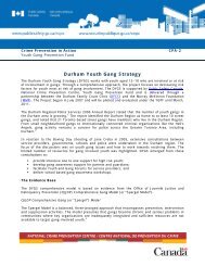
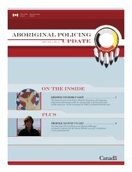
SUMMARY OF ENERGY INPUTS AND SERVICES<br />
<strong>The</strong> graphics summarize an average household’s energy inputs and services. <strong>The</strong> proportional scale between neighbourhoods is<br />
accurate and is reflected in the different size <strong>of</strong> the maps. More detailed source data can be found on pages 5 & 6.<br />
GHGs<br />
(14 tonnes<br />
C0 2<br />
e/yr)<br />
Cost<br />
($7,800/yr)<br />
Porter Creek<br />
Granger<br />
Central<br />
Business<br />
District<br />
Airport<br />
Electricity (14,700 kWh/yr)<br />
Propane (3,300 L/yr)<br />
Gasoline<br />
(3,600 L/yr)<br />
Pl<br />
Grouse Cres<br />
Heron Drive<br />
Falcon Drive<br />
ENERGY<br />
INPUTS<br />
(260 GJ/yr)<br />
Thompson Road<br />
Wilson Drive<br />
Hamilton Boulevard<br />
Turner Crescent<br />
Salter Pl<br />
Wilson Drive<br />
About 4 minutes<br />
walking or<br />
1 minute cycling<br />
250 meters<br />
Wilson Drive<br />
Park Lane<br />
Lighting<br />
and Appliances<br />
(32 GJ/yr)<br />
Hot Water (21 GJ/yr)<br />
Space Heat (85 GJ/yr)<br />
ENERGY<br />
SERVICES<br />
Hi lcrest Drive<br />
Transportation<br />
(123 GJ/yr)<br />
Wolf Creek &<br />
Mary Lake<br />
Falcon Dr<br />
GRANGER<br />
Hayes Pl<br />
GHGs<br />
(20 tonnes<br />
C0 2<br />
e/yr)<br />
Cost<br />
($9400/yr)<br />
Dogwood Street<br />
Electricity (15,100 kWh/yr)<br />
Oil (3,000 L/yr)<br />
Gasoline<br />
(4,500 L/yr)<br />
ENERGY<br />
INPUTS<br />
(320 GJ/yr)<br />
Alaska Highway<br />
14th Avenue<br />
Centennial Street<br />
Versluce Pl<br />
Elm Street<br />
Fir Street<br />
14th Avenue<br />
12th Avenue<br />
Fir Street<br />
Fir Street<br />
Grove Street<br />
Grove Street<br />
11th Avenue<br />
10th Avenue<br />
About 4 minutes<br />
walking or<br />
1 minute cycling<br />
9th Avenue<br />
Ho ly Street<br />
13th Avenue<br />
Grove Street<br />
Pine Street<br />
Spruce Street<br />
13th Avenue<br />
HemlockStreet<br />
Almond Place<br />
Pine Street<br />
11th Avenue<br />
Lighting<br />
and Appliances<br />
(32 GJ /yr)<br />
Hot Water (22 GJ/yr)<br />
Space Heat<br />
ENERGY<br />
(117 GJ/yr)<br />
SERVICES<br />
Transportation<br />
(154 GJ/yr)<br />
Mountainview<br />
250 meters<br />
PORTER CREEK<br />
www.sbc.nrcan.gc.ca 3
Larkspur Place<br />
<strong>Urban</strong> Archetypes Project Whitehorse YK<br />
CANMET Energy Technology Centre<br />
GHGs<br />
(25 tonnes<br />
C0 2<br />
e/yr)<br />
Cost<br />
($11,600/yr)<br />
HarveyPlace<br />
Nansen Drive<br />
Harvey Road<br />
Lighting and<br />
Appliances (33 GJ/yr)<br />
Boss Road<br />
Arke l Place<br />
Hot Water (21 GJ/yr)<br />
Logan Road<br />
Harbottle Road<br />
Phelps Place<br />
Langholz Road<br />
Harbottle Road<br />
Cronkhite Road<br />
Dawson Road<br />
Castle Drive<br />
Keele Place<br />
Tombstone Pl<br />
Logan Road<br />
ENERGY<br />
SERVICES<br />
Space Heat (142 GJ/yr)<br />
Transportation<br />
(204 GJ/yr)<br />
Cronkhite Road<br />
Ryder Place<br />
Fireweed Drive<br />
Dawson Road<br />
Orchid Place<br />
Salmon Trail<br />
Sage Place<br />
Fireweed Drive<br />
Lupin Place<br />
Sockeye Place<br />
Chum Place<br />
Electricity (14,900 kWh/yr)<br />
Aster Place<br />
Kokanee Place<br />
Fireweed Drive<br />
Oil (3,600 L/yr)<br />
Gasoline<br />
(5,900 L/yr)<br />
ENERGY<br />
INPUTS<br />
(400 GJ/YR)<br />
Iris Place<br />
Crocus Place<br />
Columbine Place<br />
Fireweed Drive<br />
Bluebe l Place<br />
Salmon Trail<br />
Do ly Varden Drive<br />
Do ly Varden Drive<br />
Grayling Place<br />
Coho Trail<br />
Chinook Lane<br />
Marigold Place<br />
Buttercup Place<br />
About 4 minutes walking<br />
or 1 minute cycling<br />
250 meters<br />
WOLF CREEK & MARY LAKE<br />
Legend for Area Maps<br />
Residential<br />
<strong>Study</strong> area with<br />
residential lots<br />
Land Use<br />
Retail/Commercial<br />
Industrial<br />
Institutional<br />
Municipal<br />
Recreational<br />
Parkland<br />
Water<br />
Transportation<br />
Arterial (with sidewalks)<br />
Collector (with sidewalks)<br />
Local (with sidewalks)<br />
Roads without sidewalks<br />
Alleys<br />
Pathways<br />
Bike lanes, bike paths<br />
Bus routes<br />
4<br />
www.sbc.nrcan.gc.ca
CANMET Energy Technology Centre<br />
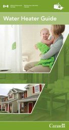
ENERGY USE IN HOUSES<br />
<strong>The</strong> amount <strong>of</strong> energy consumed to provide the energy services<br />
<strong>of</strong> space heating, domestic hot water heating, lighting and<br />
appliances can vary substantially from house to house. Factors<br />
influencing household energy consumption include: levels <strong>of</strong><br />
insulation and airtightness, efficiency <strong>of</strong> mechanical systems for<br />
space heating and hot water, choice <strong>of</strong> lighting and appliances,<br />
size <strong>of</strong> house, and occupant lifestyles.<br />
162 GJ<br />
$4,330<br />
8.3 tonnes<br />
171 GJ<br />
$4,540<br />
8.9 tonnes<br />
<strong>The</strong> energy consumption <strong>of</strong> common house types found within<br />
the Whitehorse study areas ranges from 138 GJ to 205 GJ per<br />
205 GJ<br />
$5,320<br />
11.7 tonnes<br />
174 GJ<br />
$4,600<br />
9.2 tonnes<br />
196 GJ<br />
$5,120<br />
10.7 tonnes<br />
175 GJ<br />
<strong>Urban</strong> Archetypes Project Whitehorse YK<br />
year. For homes heated with oil, this represents 2,750 litres to<br />
4,000 litres per year. For those heated with propane, it ranges<br />
from 3,250 litres to 4,650 litres per year. <strong>The</strong> electricity use<br />
for all houses ranges from 13,600 to 15,100 kilowatt hours<br />
per year for hot water heating, lighting and appliances. Given<br />
this consumption, energy costs 5 range from $3,890 to $5,320<br />
per year for the use <strong>of</strong> a combination <strong>of</strong> oil or propane and<br />
electricity; associated greenhouse gas emissions range from<br />
5.5 tonnes to 11.7 tonnes <strong>of</strong> equivalent CO 2<br />
per year.<br />
$4,820<br />
7.6 tonnes<br />
138 GJ<br />
$3,890<br />
5.5 tonnes<br />
Porter Creek Wolf Creek & Mary Lake Granger<br />
ENERGY SERVICES<br />
Lighting and Appliances<br />
Domestic Hot Water<br />
Space Heat<br />
COST<br />
Electricity<br />
Propane<br />
Oil<br />
GHG EMISSIONS<br />
A B A B C A B<br />
Equivalent C0 2<br />
5.5 tonnes<br />
$3,890<br />
138 GJ<br />
7.6 tonnes<br />
$4,820<br />
175 GJ<br />
10.7 tonnes<br />
$5,120<br />
196 GJ<br />
9.2 tonnes<br />
$4,600<br />
174 GJ<br />
11.7 tonnes<br />
$5,320<br />
205 GJ<br />
8.9 tonnes<br />
$4,540<br />
171 GJ<br />
8.3 tonnes<br />
$4,330<br />
162 GJ<br />
Building Type storeys One-storey One-storey Two-storeys Two-storeys One-storey Two-storeys One-storey<br />
attachment single-detached single-detached single-detached single-detached single-detached single-detached single-detached<br />
built 1978-1983 1961-1977 after 1995 1984-1995 1978-1983 1984-1995 1984-1995<br />
Heated Floor Area 185 m 2<br />
(2,000 sq.ft.)<br />
200 m 2<br />
(2,150 sq.ft.)<br />
260 m 2<br />
(2,800 sq.ft.)<br />
235 m 2<br />
(2,500 sq.ft.)<br />
240 m 2<br />
(2,600 sq.ft.)<br />
300 m 2<br />
(3,200 sq.ft.)<br />
225 m 2<br />
(2,400 sq.ft.)<br />
Insulation ceiling RSI 5.7 (R-32) RSI 4.6 (R-26) RSI 6.0 (R-34) RSI 7.0 (R-40) RSI 4.2 (R-24) RSI 6.0 (R-34) RSI 6.3 (R-36)<br />
Space<br />
Heating<br />
walls RSI 2.4 (R-14) RSI 2.3 (R-13) RSI 2.9 (R-16) RSI 3.6 (R-20) RSI 2.3 (R-13) RSI 3.6 (R-20) RSI 2.9 (R-16)<br />
foundation RSI 2.1 (R-12) RSI 2.3 (R-13) RSI 3.1 (R-18) RSI 2.6 (R-15) RSI 2.4 (R-14) RSI 3.7 (R-21) RSI 3.1 (R-18)<br />
fuel oil oil oil oil oil propane propane<br />
furnace<br />
furnace with flame<br />
retention head<br />
furnace with flame<br />
retention head<br />
furnace with flame<br />
retention head<br />
mid-efficiency<br />
furnace<br />
furnace with flame<br />
retention head<br />
condensing<br />
furnace<br />
efficiency 83% 83% 83% 85% 83% 87% 87%<br />
condensing<br />
furnace<br />
Hot Water fuel electric electric electric electric electric electric electric<br />
Lighting<br />
Appliances<br />
ENERGY SERVICES<br />
Lighting and Appliances<br />
Domestic Hot Water<br />
Space Heat<br />
COST<br />
Electricity<br />
Propane<br />
Oil<br />
tank conventional tank conventional tank conserver tank conserver tank conserver tank conserver tank conserver tank<br />
efficiency 82% 82% 87% 87% 87% 87% 87%<br />
GHG EMISSIONS<br />
Equivalent C0 2<br />
standard<br />
residential<br />
incandescent<br />
lighting<br />
standard<br />
appliances<br />
standard<br />
residential<br />
incandescent<br />
lighting<br />
standard<br />
appliances<br />
standard<br />
residential<br />
incandescent<br />
lighting<br />
standard<br />
appliances<br />
standard<br />
residential<br />
incandescent<br />
lighting<br />
standard<br />
appliances<br />
standard<br />
residential<br />
incandescent<br />
lighting<br />
standard<br />
appliances<br />
standard<br />
residential<br />
incandescent<br />
lighting<br />
standard<br />
appliances<br />
Occupants 4 4 3 4 4 4 4<br />
standard<br />
residential<br />
incandescent<br />
lighting<br />
standard<br />
appliances<br />
5 Average costs were calculated using available price data for Whitehorse: Oil (93.9 ¢/L, 2006 average), Propane (67¢/L, 2006 average)<br />
and Electricity (11.5 ¢/kWh, 2005 average).<br />
www.sbc.nrcan.gc.ca 5
<strong>Urban</strong> Archetypes Project Whitehorse YK<br />
CANMET Energy Technology Centre<br />
Energy Use for Personal Vehicle Transportation 6<br />
Personal transportation helps Canadians accomplish a wide<br />
variety <strong>of</strong> activities and is essential to the functioning <strong>of</strong> our<br />
communities. Personal vehicles are the predominant form <strong>of</strong><br />
personal transportation, accounting for 78% <strong>of</strong> total passenger<br />
transportation energy end-use in Canada in 2005 7 .<strong>The</strong> <strong>Urban</strong><br />
Archetypes Project calculated energy consumption for personal<br />
vehicles 8 and additionally examined public transit and the active<br />
modes <strong>of</strong> walking and cycling.<br />
Factors influencing transportation energy consumption for<br />
personal vehicles considered here include distance travelled,<br />
vehicle type, and fuel efficiency. <strong>The</strong> influence <strong>of</strong> neighbourhood<br />
design characteristics, neighbourhood location and lifestyle<br />
were analyzed across all neighbourhoods included in the study,<br />
the results <strong>of</strong> which are presented in <strong>The</strong> <strong>Urban</strong> Archetypes<br />
Methodology.<br />
Average annual household Vehicle Kilometres Travelled 9<br />
(VKT) in the Whitehorse study areas ranged from 30,700 km<br />
to 42,000 km. In 2006, the average study area household<br />
consumed between 3,560 and 5,885 litres <strong>of</strong> gasoline that cost 10<br />
between $3,898 and $6,444, and produced greenhouse gas<br />
emissions <strong>of</strong> between 9 and 14 tonnes <strong>of</strong> equivalent CO 2<br />
.<br />
ENERGY INPUTS<br />
Gasoline (L)<br />
ENERGY INPUTS<br />
Gasoline (L)<br />
Cost<br />
Porter Creek Wolf Creek & Mary Lake Granger<br />
Cost<br />
GHG Emissions<br />
(Equivalent C0 2<br />
)<br />
GHG Emissions<br />
(Equivalent C0 2<br />
)<br />
154 GJ<br />
154 GJ<br />
(4,500 L/yr)<br />
(4,500 L/yr)<br />
10.7 tonnes<br />
10.7 tonnes<br />
$4,887<br />
$4,887<br />
204 GJ<br />
204 GJ<br />
(5,900 L/yr)<br />
(5,900 L/yr)<br />
14.1 tonnes<br />
14.1 tonnes<br />
$6,4440<br />
$6,4440<br />
123 GJ<br />
123 GJ<br />
(3,600 L/yr)<br />
(3,600 L/yr)<br />
8.5 tonnes<br />
8.5 tonnes<br />
$3,898<br />
$3,898<br />
Neighbourhood Design Gross Density 4.00 UPH 0.46 UPH 6.60 UPH<br />
Neighbourhood Location<br />
Resident Lifestyle<br />
Percent <strong>of</strong> Housing Units<br />
Single Detached<br />
93% 98% 88%<br />
Land Use Mix Index 0.31 0 0.39<br />
Total Road Length 7.9 km 22.8 km 6.0 km<br />
Distance to Central<br />
Business District<br />
Average Number <strong>of</strong><br />
Vehicles per Household<br />
6.4 km 15.0 km 3.2 km<br />
2.4 2.5 1.9<br />
Vehicle Kilometers Traveled (VKT) 30,700 km 42,000 km 24,400 km<br />
PROJECT COLLABORATION<br />
Natural Resources Canada recognizes the contribution <strong>of</strong><br />
project collaborators in Whitehorse including the <strong>City</strong> <strong>of</strong><br />
Whitehorse, the Northern Climate Exchange, Yukon Electric<br />
and North 60° Petro.<br />
FOR MORE INFORMATION<br />
To learn more about the <strong>Urban</strong> Archetypes Project, or to access<br />
project companion documents (Methodology and additional case<br />
studies), go to www.sbc.nrcan.gc.ca or contact Jessica Webster by<br />
phone: (613) 992-9532 or email: jessica.webster@nrcan.gc.ca.<br />
6<br />
Indicator definitions can be found in <strong>The</strong> <strong>Urban</strong> Archetypes Project Methodology (www.sbc.nrcan.gc.ca).<br />
7 Passenger Transportation Secondary Energy Use by Energy Source and Transportation Mode<br />
http://www.oee.nrcan.gc.ca/corporate/statistics/neud/dpa/tableshandbook2/tran_00_4_e_2.cfm?attr=0.<br />
8 Personal vehicles include small and large cars and light trucks.<br />
9 Based on total household VKT-AVG responses, collected from study area residents in 2006. See <strong>Urban</strong> Archetype Project Methodology for more details.<br />
10 Average costs were calculated using available price data for Whitehorse: Gasoline ($1.095/L, 2006 average).<br />
6<br />
www.sbc.nrcan.gc.ca