behind scenes - Source
behind scenes - Source
behind scenes - Source

You also want an ePaper? Increase the reach of your titles
YUMPU automatically turns print PDFs into web optimized ePapers that Google loves.
Riabhach, the grey ridge, which may<br />
have been anglicised to Rockbrook.<br />
The other possible origin of Rockbrook<br />
is of course the literal name taken<br />
from the rocky brook which flows<br />
through the village. Mention has been<br />
made of the Owen Doher river. The<br />
Irish spelling is Abhainn Dothair, the<br />
ancient Irish name for the Dodder into<br />
which the Owen Doher flows at Rathfarnham.<br />
It is curious that the tributary<br />
has taken the old name of the larger river.<br />
The second stream coming down<br />
through Kelly's Glen and along Whitechurch<br />
Road has been called the River<br />
Glin, although an old map of the Kilmashogue<br />
area refers to it as the Kilmashogue<br />
River. The Little Dargle River<br />
flows northwards through Marlay Park.<br />
Much of the area is mountainous and<br />
sparsely populated. In 1837 the population<br />
of Whitechurch parish was 1710<br />
and that of Cruagh 1216, whilst by 1841<br />
the combined total was down to 2354.<br />
Readers will have noticed the two<br />
forms of spelling Marlay used in this<br />
geographical description. Marlay appears<br />
to be the correct spelling for the<br />
house and estate as this is the way in<br />
which the bishop's name was spelt.<br />
Marley Grange and the Marley Park Hotel<br />
have adopted the slightly altered<br />
version.<br />
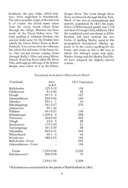
Townlands included in Whitechurch<br />
Parish<br />
Townland<br />
Ballyboden<br />
Clarkstown<br />
Cruagh<br />
Edmondstown<br />
Glendoo<br />
Haroldsgrange<br />
Jamestown<br />
Killakee<br />
Kilmashogue<br />
Newtown<br />
Orlagh<br />
Stackstown<br />
Taylorsgrange<br />
Tibradden<br />
Whitechurch<br />
Woodtown<br />
Ballyboden—Town<br />
Edmondstown—Town<br />
Totals<br />
Scholarstown*<br />
Area<br />
A-R-P<br />
125-3-12<br />
81-3-26<br />
947-3- 6<br />
226-0-36<br />
931-1- 1<br />
341-2-27<br />
92-1-36<br />
661-0-27<br />
1,409-2- 9<br />
450-0-30<br />
43-2- 5<br />
175-3-32<br />
451-3-39<br />
842-3-31<br />
60-1- 6<br />
488-3-33<br />
—<br />
—<br />
7,333-2-36<br />
200-2-39<br />
1841 Pop<br />
134<br />
22<br />
167<br />
160<br />
10<br />
270<br />
130<br />
258<br />
243<br />
20<br />
21<br />
58<br />
243<br />
64<br />
166<br />
252<br />
136<br />
2,354<br />
75<br />
7,534-1-35 2,429<br />
*Scholarstown was included in the parish of Rathfarnham in 1841.<br />
4