Download (36Mb) - Aquatic Commons
Download (36Mb) - Aquatic Commons
Download (36Mb) - Aquatic Commons

Create successful ePaper yourself
Turn your PDF publications into a flip-book with our unique Google optimized e-Paper software.
The opening of the Panama Canal had a<br />
vitalizing effect on commerce and trade between<br />
the nations of the American continents<br />
THE IDEA first contemplated four centuries<br />
ago of constructing a canal to join the<br />
two great oceans was inspired by the desire<br />
to move commodities from the Atlantic to the<br />
Pacih.c with greater speed and facility. Four<br />
hundred years ago important items of trade<br />
included pungent spices from the East Indies,<br />
worth almost their weight in gold, lustrous silks<br />
from China, gold and silver from the rich Mexican<br />
and Peruvian mines, and cochineal from Mexico<br />
and Central America to dye the royal· robes of<br />
Europe. .<br />
Although cargoes of these precious materials<br />
have been shipped through the Panama Canal<br />
during the last 25 years, they have formed an<br />
insignificant part of the more than one-half billion<br />
tons of cargo that has been moved through the<br />
Canal since it was opened to sea-borne traffic.<br />
They are relatively unimportant items in today's<br />
world trade, and more prosaic articles, such as<br />
oil, lumber, cotton, wheat, canned goods, fresb<br />
and dried fruits, nitrates, iron ore, automobiles,<br />
and manufactured articles of a wide variety,<br />
many of which were unknown to the arrogant<br />
courts of Europe during the sixteenth century or<br />
of no interest to them, now make up the bulk<br />
of the millions of tons of cargo transported<br />
through the Canal annually by the commercial<br />
fleets of the world.<br />
The primary functi8n of the Panama Canal is<br />
to facilitate the movement of commodities<br />
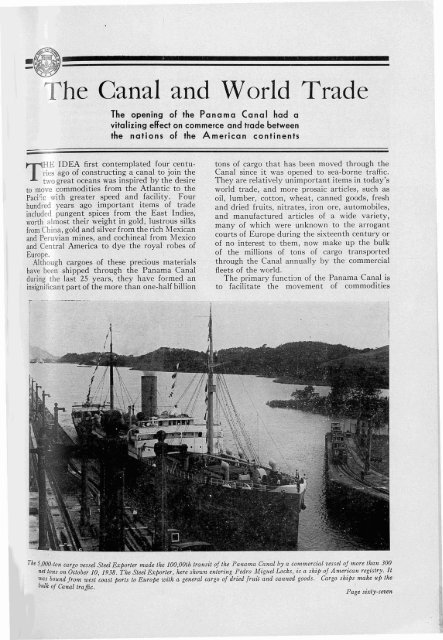
The 5,000-ton cargo vessel Steel Exporter m.ade the 100,00th transit of the Panama Canal by a commercial vessel of more than 300<br />
net. tons on October 10, 1938. The Steel Exporter, here shown entering Pedro Miguel Locks, is a ship of A merican registry. It<br />
was bound from west coast ports to Europe with a general cargo of dried fruit and canned goods. Cargo ships make liP the<br />
bulk of Canal traffic.<br />
Page sixty-seven
August 15, 1914 THE PANAMA CANAL August 15, 1939<br />
between the oceans and the manifold activities<br />
of the Canal enterprises are all fashioned and<br />
operated "vith that end in view.<br />
It is only natural that the Panama Canal has<br />
had a great influence on world commerce. New<br />
trade routes have developed, and many countries<br />
which were isolated trade areas before its opening<br />
have been brought within the radius of great<br />
world markets. Ships have been saved thousands<br />
of miles in distances, and the consequent economy<br />
in the movement of commodities proved<br />
a great stimulus in the development of agriculture,<br />
manufacturing and mining in many new<br />
areas. In turn, the development of such areas into<br />
thriving, prosperous communities as well as the<br />
fluctuations in world commerce have an important<br />
effect on the volume of shipping through<br />
the Canal.<br />
It would require a book-length report to<br />
describe in detail the effect the Panama Canal<br />
has had on wo'rld commerce. It is only possible<br />
in a brief article to point out some of the outstanding<br />
movements of cargo and to describe<br />
some of the fluctuations in cargo movement because<br />
of changing economic conditions.<br />
Up to July 1, 1939, 104,417 ocean-going vessels<br />
had transited the Canal from one ocean to the<br />
other. On these were transported 498,790,675<br />
tons of cargo. In addition 8,199 commercial<br />
vessels of less than 300 tons net have transited,<br />
carrying cargo which aggregated 286,525 tons<br />
over the 25-year period, making a grand total<br />
of 499,077,200 tons of cargo moved through<br />
the Canal since it was opened. The half-billion<br />
--=<br />
ton mark was exceeded during the month of July,<br />
about one month before the twenty-fifth anniversary<br />
of the opening of the Canal on August 15,<br />
Although the great majority of these vessels and<br />
the major proportion of thiscargo was in movement<br />
over well defined trade routes between the<br />
larger ports of the world, hundreds of ships have<br />
transited with cargo for the farthest outposts of<br />
civilization and to wayports of world trade. This<br />
enormous traffic is composed of vessels of practically<br />
all nationalities and the half-billion tons of<br />
cargo was composed of practically every item<br />
used by mankind, including the exotic luxuries<br />
as well as all the common necessaries of life.<br />
Unsettled economic conditions during and for<br />
a few years after the close of the World War<br />
disrupted trade routes, and traffic through the<br />
Canal did not reach a normal level until nearly<br />
ten years after the Isthmian waterway was<br />
opened. It was not until 1920, six years after<br />
the open'ing of the Canal, that the number of<br />
transits exceeded 2,000 and not until 1921 that<br />
the amount of cargo exceeded 10,000,000 tons in<br />
anyone year. However, from that time until the<br />
full effect of the world-wide depression was felt<br />
in shipping, there was a gradual increase in the<br />
flow of traffic and the movement of commodities.<br />
The peak was reached in the fiscal year 1929 when<br />
6,289 vessels transited the Canal and more than<br />
30,000,000 tons of cargo were transported, which<br />
nearly equalled the total number of vessels and<br />
total amount of cargo which moved through the<br />
Canal during the first five years following its<br />
opening in 1914.<br />
Traffic statistics covering ocean-going vessels for each fiscal year since the Canal was opened to navigation:<br />
Fiscal year ended June 30-<br />
Number Panama Canal I<br />
of transits net tonnage J<br />
----------------_.__._--<br />
Tolls Tons of cargo<br />
1915' ____ _____ ____ ____ ___ _ __ _______ ___ _____ 1,058 3,507,000 $4,366,747.13 4,888,400<br />
1916 2 __ _ _ _ _ _ __ _ _ __ _ __ __ _ _ _ __ _ __ _ _ _ _ _ _ _ _ _ _ __ __ _ _ _ _ 724 2,212,000 2,403,089.40 3,093,335<br />
1917 __ ___ ___ __ __ ____ ______ _ ___ ______ _ 1,738 5,357,000 5,620,799.83 7,054,720<br />
1918__ _ __ ___ 1,989 6,072,000 6,428,780.26 7,525,768<br />
1919_____ __ ___ ____ ___ _______ ____________ ___ _______ 1,948 5,658,000 6,164,290.79 6,910,097<br />
1920____ _____ _____ _____________________________ ______ 2,393 7,898,000 8,507,938.68 9,372,374<br />
192L__ ____ _________________________________________ 2,791 10,550,000 11,268,681.46 11,595,971<br />
1922..__ ___ __ _____ __ ___ __ ___ ____________ __________ 2,665 10,556,000 11,191,828.56 10,882,607<br />
1923_________________________________________________ 3,908 17,206,000 17,504,027.19 19,566,429<br />
1924____ _____ _____ _____ _____ __ _____________ __ 5,158 24,181,000 24,284,659.92 26,993,167<br />
1925____ ___ _____________ ___________ _________ ____ _____ 4,592 21,134,000 21,393,718.01 23,956,549<br />
1926___ ____ _ _____ __ __ ___ ____________ _____ 5,087 22,906,000 22,919,931.89 26,030,016<br />
1921..__ ____________________________ _______________ __ 5,293 24,245,000 24,212,250.61 27,733,555<br />
1928____ _________________________ _____ __ ______ __ __ 6,253 27,229,000 26,922,200.75 29,615,651<br />
1929 ~ ____ __________ 6,289 27,585,000 27,111,125.47 30,647,768<br />
1930____ ____ ____________________ __________ ______ __ ___ 6,027 27,716,000 27,059,998.94 30,018,429<br />
193L____ __ ____ ____ ___ _________ ____________ ____ __ 5,370 25,690,000 24,624,599.76 25,065,283<br />
1932___ __ ______ _____ _____ __________ _______ ____ 4,362 21,842,000 20,694,704.61 19,798,986<br />
1933____ ______ __ ______ __ _____ __ ____ ____________ 4,162 21,094,000 19,601,077.17 18,161,165<br />
1934_________ __ __ ______ __________ _____ ___ ____ ______ __ 5,234 26,410,000 24,047,183.44 24,704,009<br />
1935____ __ _____ __________ _ _____ __ ________ 5,180 25,720,000 23,307,062.93 25,309,527<br />
1936____ __ __ __ _ ____ __ ___ ____ ___________ ___ _____ 5,382 25,923,000 23,479,114.21 26,505,943<br />
1937 ____ ____________ _____________ __ ___ __ __ ____ 5,387 25,430,000 23,102,137.12 28,108,375<br />
1938____ __ ____ ____ __ ___ _____ ____ __ __________ __ 5,524 25,950,383 23,169,888.70 27,385,924<br />
1939 - .. _____ _________ __________ ____ __ __ _____ __ ____ 5,903 27,170,007 23,661,021.08 27,866,627<br />
TotaL ~_____ 104,417 469,241,390 453,046,857.91 498,790,675<br />
1 Canal opened to traffic August 15, 1914. 'Canal closed to traffic approximately seven moilths of fiscal year because of slides. 3 Comparable<br />
Panama Canal net tonnage pnor to 1939 is estimated, being based on revised measurement rules which became effective March 1, 1938 (tonnage<br />
figures are now approxllnately 92.5 percent of the tonnage under measurement rules in effect before that date.)<br />
Page sixty-eight
August 15, 1914 THE CANAL AND WORLD TRADE August 15, 1939<br />
ASIA<br />
woRiD MAP<br />
SHOWING DlSTANCES SAvm<br />
VIA THE PANAMA CANAL IN HAUTlCAL MILES<br />
NEW \"ORI. TO $A.'" FRA...CISCO•••••••••••••• •••••••••1.I7J<br />
~i: i~..,~~°u¥~~~::::::::::::::::::::::~m<br />
tR'~ ~ ~ru::"~~.::::::::::::::::::::::::::~::<br />
All but a small percentage of the traffic through the Panama Canal is moved over ten main trade routes. The following<br />
table gives the amount of cargo which was moved through the Canal over these routes during the fiscal year 1939:<br />
Tons of cargo<br />
Tons of cargo<br />
United States Intercoastal:<br />
Atlantic to Pacific<br />
Pacific to Atlantic<br />
TotaL<br />
United States and Far East (excluding<br />
Philippines) :<br />
Atlantic to Pacific<br />
Pacific to Atlantic<br />
TotaL<br />
_<br />
Europe and West Coast of United States:<br />
Atlantic to Pacific<br />
_<br />
Pacific to Atlantic<br />
_<br />
TotaL<br />
urope and West Coast of Canada:<br />
Atlantic to Pacific<br />
Pacific to Atlantic<br />
_<br />
_<br />
_<br />
_<br />
_<br />
_<br />
_<br />
_<br />
Total<br />
_<br />
ast Coast United States and West Coast<br />
of South America:<br />
Atlantic to Pacific<br />
_<br />
Pacific to Atlantic<br />
_<br />
TotaL<br />
urope and South America:<br />
Atlantic to Pacific<br />
Pacific to Atlantic<br />
TotaL<br />
_<br />
_<br />
_<br />
_<br />
2,391,523<br />
4,493,203<br />
6,884,726<br />
2,593,808<br />
280,593<br />
2,874,401<br />
337,401<br />
2,349,888<br />
2,687,289<br />
78,789<br />
2,539,436<br />
2,618,225<br />
192,732<br />
2,447,257<br />
2,639,989<br />
415,697<br />
2,481,541<br />
2,897,238<br />
Europe and Australasia:<br />
Atlantic to Pacific<br />
Pacific to Atlantic<br />
TotaL<br />
United States and Australasia:<br />
Atlantic to Pacific<br />
Pacific to Atlantic<br />
TotaL<br />
United States and Hawaiian Islands:<br />
Atlantic to Pacific<br />
Pacific to Atlantic<br />
TotaL<br />
United States and Philippine Islands:<br />
Atlantic to Pacific<br />
Pacific to Atlantic<br />
TotaL<br />
Miscellaneous Routes and Sailings:<br />
Atlantic to Pacific<br />
Pacific to Atlantic<br />
TotaL<br />
Total traffic, all routes:<br />
Atlantic to Pacific<br />
Pacific to Atlantic<br />
TotaL<br />
_<br />
_<br />
_<br />
_<br />
_<br />
_<br />
_<br />
_<br />
_<br />
_<br />
_<br />
_<br />
_<br />
_<br />
_<br />
_<br />
_<br />
_<br />
542,770<br />
759,794<br />
1,302,564<br />
378,468<br />
86,999<br />
465,467<br />
137,880<br />
361,857<br />
499,737<br />
277,399<br />
918,937<br />
1,196,336<br />
1,664,800<br />
2,135,855<br />
3,800,655<br />
9,011,267<br />
18,855,360<br />
27,866,627<br />
Page sixty-nine
August 15, 1914 THE PANAMA CANAL August 15, 1939<br />
Of the main routes the most important is that<br />
between the Atlantic and Pacific coasts of the<br />
United States. It was anticipated long before<br />
the Canal was opened that the traffic over this<br />
route would be heavy. The trade between the<br />
two coasts did not reach the higher levels until<br />
several years after the World War when idle<br />
tonnage of vessels built by the Government and<br />
intercoastal vessels which had transferred to the<br />
more profitable European trade were returned to<br />
their regular runs. These factors, coupled with<br />
of cargo, passed through the Canal. Since that<br />
time there has been a general improvement in<br />
world trade which has been reflected in a greater<br />
movement of shipping through the Canal.<br />
During the fiscal year 1939 there were .),903<br />
vessels, carrying 27,866,627 tons of cargo, both<br />
figures approaching the records established just<br />
ten years before.<br />
Although there is a wide variety of comp10dities<br />
shipped from the west coast to the e&. ...tern<br />
seaboard ports, the great bulk of the shipments<br />
Traffic did not reach a norrnallevel through the Canal nntil more th:Lil jiue years after it was opene:1, chiefly bJcause of the disrup·<br />
t'ion of trade routes during the World War, However, landslides kept the Canal closed for more than half thejiscal yea.r 1916,<br />
This picture of a disastrous slide in Gaillard Cut was taken on October 5, 1915.<br />
the large shipments of oil from the California<br />
fields, were the principal factors in bringing the<br />
traffic to the high levels reached between 1923<br />
and 1930 reaching the highest point in the fiscal<br />
year 1924 when there were 1,704 transits of<br />
tankers. Tanker traffic was an important component<br />
of the cargo shipments through the Canal<br />
during that period, but there has since been a<br />
gradual decline and during the past Escal year<br />
there were only 580 transits of tankers.<br />
During the ten-year period just. ended there<br />
was a great decline in the movement of ships and<br />
commodities on all trade routes through the<br />
Canal; the lowest point being reached in 1933<br />
when only 4,162 vessels, carrying 18,161,165 tons<br />
Page seventy<br />
is made up of mineral oil, wheat and other<br />
cereals, lumber, canned food products, food products<br />
in cold storage, and fresh and dried f.·uits.<br />
Of these one of the most important items is the<br />
lumber shipped from the great forests of the<br />
Pacific slope. The tonnage of cargo shipped from<br />
the west to the east coast of the United States is<br />
approximately twice as great as that which<br />
moved from the Atlantic to the Pacific seaboard.<br />
This is also generally true of all the other trade<br />
routes; however, the value of the cargoes is more<br />
nearly equal, as most of the westbound cargo is<br />
made up of finished manufactures. Manufactures<br />
of iron and steel constitute the greatest<br />
part of the commodities shipped from the Atlan-
August 15, 1914 THE CANAL AND WORLD TRADE August 15, 1939<br />
tic to the Pacif.c coast of the ~~ited St.ates via<br />
the Canal. Other commodities whlch are<br />
shipj:ed in large quantities over this route from<br />
east tll west include automobiles, machinery,<br />
paper ~ll1d p~per products, coal and coke, and<br />
variou, chemicals.<br />
An uutstanding example of the fluctuation in<br />
the movement of commodities over the various<br />
trade routes caused by changing economic conditionE.<br />
is found on the important route between<br />
European ports and the west coast of North<br />
America. There was a sudden rise in the amount<br />
of shipping over this route during the fiscal year<br />
1939,
August 15, 1914 THE PANAMA CANAL August 15,1939<br />
Practically all of the wheat shipped through the<br />
Canal is destined to Europe.<br />
Perhaps no large area benefited more from the<br />
opening of the Panama Canal than the west<br />
coast of South America. Until the Canal was<br />
opened to traffic, vessels had to make the long,<br />
costly trip around South America to reach the<br />
rich potential markets in Chile, Peru and Ecuador,<br />
as well as the Pacific ports of Colombia.<br />
A small portion of this trade was brought to<br />
Panama and transshipped across the Isthmus to<br />
tries were enabled to buy fertilizer containing<br />
this important component at a much lower price<br />
than hitherto obtained. During the World War<br />
the importance of obtaining nitrates became so<br />
great that several of the Panama Railroad ships<br />
were diverted to this trade during the period<br />
when commercial shipping was disrupted. The<br />
shipments of nitrates since about 1921 have l,een<br />
more or less regular and the fluctuations which<br />
are shown from year to year are mainly the<br />
result of changes in economic standards through-<br />
Cl'istobal Harbor, once little more than an open roadstead, is now one of the world's finest ports. The large covered piers, in the<br />
center of this aerial view of the Atlantic port, are provided with adequate facilities for cargo handling. A large coaling plant<br />
and oil-handling pla.nt provide for refueling.<br />
Atlantic ports on the west coast of South and<br />
Central America. All commerce along this west<br />
coast was greatly stimulated by the opening of<br />
the Canal which provided a ready outlet for the<br />
valuable mineral deposits and other natural<br />
resources.<br />
Among the first vessels to transit the Canal<br />
during 1914 'were those loaded with Chilean<br />
nitrates, and this commodity has been one of the<br />
leaders in the cargo lists in e9-ch of the 2S years<br />
of operation. A ready access to a great source<br />
of nitrate also had its effect in the United States<br />
and Europe as farmers throughout those coun-<br />
out the world. In 1921 the tonnage of nitrate<br />
shipments to Atlantic ports was greater than any<br />
other commodity. Since that time, however,<br />
several other commodities, including mineral oil,<br />
lumber, ores and manufactures of iron and steel<br />
have exceeded it in tonnage, although nitrate<br />
shipments have remained, with few exceptions,<br />
at a fairly constant figure of above 1,000,000<br />
tons annually.<br />
Iron ore and c0rlper shipments through the<br />
Canal from South America, which did not become<br />
important until after the World War,<br />
have become during the past few years leading<br />
Page seventy-two
tgust 15, 1914 THE CANAL AND WORLD TRADE August 15, 1939<br />
Ships may refuel at either of the two Canal ports. This i:: a<br />
pic/me of the U. S. Army transport Mt. Vernon bunkerzng<br />
coal ai/he Cristobal coaling plant.<br />
commodities in point of tonnage. This trade<br />
showed a continuous growth until the full<br />
effects of the world-wide depression were felt in<br />
the iron and steel industry and in the year 1933<br />
shipments of ore from South America through<br />
the Canal aggregated less than 100,000 tons, as<br />
compared with more than 600,000 tons during<br />
the previous year. Heavily laden ore ships<br />
began to move through the Canal in a steady<br />
stream after the slump of 1933 and in no year<br />
since has the tonnage been less than 1,000,000.<br />
In the fi£cal year 1938 ore shipments aggregated<br />
more than 2,000,000 tons, and during the past<br />
fiscal year the total tonnage of ores was 1,991,690.<br />
Although iron ores and nitrates compose the<br />
bulk of shipments from South America through<br />
the Canal over the trade routes to the United<br />
States and to European ports, many other commodities<br />
are shipped from the west coast ports<br />
which have a great influence on the prosperity of<br />
certain areas there. Among the products<br />
shipped in large quantities every year are skins<br />
and hides, mineral oil from Ecuador and Peru<br />
to Europe, fruits, coffee, raw cotton, beans,<br />
ivory nuts and cereals.<br />
Although the greatest number of ships and<br />
the greatest amount of cargo moving through<br />
the Canal follow four principal routes, viz.,<br />
United States intercoastal; United States and<br />
West Coast of South America; Europe and the<br />
West Coast of North America; and Europe and<br />
the West Coast of South America, a considerable<br />
proportion of the traffic every year is over the<br />
routes between the United States and Hawaii,<br />
the Philippines, the Far East, and Australasia,<br />
and between Europe and Australasia.<br />
An important aspect of the commerce on these<br />
routes is that the overwhelming proportion of the<br />
cargo on the United States-Far East route is<br />
moved trom the Atlantic to the Pacific, whereas<br />
on almost all other routes the reverse is true.<br />
'During the past year approximately 90 percent<br />
of all cargo moved on this route was shipped<br />
from United States ports to the Far East. The<br />
trade balance between the United States and<br />
Australasia, as indicated in cargo tonnage over<br />
that route, is approximately twice as great from<br />
the United States to Australasia. This condition<br />
is accounted for by the fact that a large portion<br />
of the raw products of Australasia, particularly<br />
those of New Zealand, is shipped to Europe.<br />
Cargo movement between Europe and Australasia<br />
shows little fluctuation from year to year,<br />
approximately 1,000,000 tons having been moved<br />
annually over this route during the past 20 years.<br />
The amount of cargo shipped from Australasia<br />
to Europe is much greater than from Europe<br />
to Australasia. The p:-incipal commodities<br />
moved over this route are refrigerated meats,<br />
dairy products, wool, sugar, skins and hides<br />
If,ere are wide Ructualions from year to year in the number of ships of the various nationalities and the amount of cargo carried<br />
by the ships of each nation. The following table shows the amount of cargo carried by ships of ten leading maritime nations<br />
during each of the past five fiscal years and the percentage of total cargo carried by ships of each nationality in the fiveyear<br />
period·<br />
Nationality<br />
1935 1936 1937 1933 1939<br />
Pcrcent-<br />
I I I I I<br />
age<br />
United Statcs_________________________ 10,825,573 10,700,535 9,844,254 9,892,619<br />
British_______________________________<br />
9,909,380 37.9<br />
5,776,021 6,181,571 7,179,136 6,417,016 6,801,556 23.9<br />
2,463,675 2,717,860 3,506,109 3,433,571 3,408,078 11.5<br />
k~~~~~~~~~==========================<br />
crman ______________________________<br />
1,446,049 1,697,880 1,789,178 1,877,502 1,710,303 6.3<br />
1,300,991 1,305,090 1,496,084 1,518,593 1,468,99G 5.2<br />
wed ish 782,548 855,409 775,800 763,049 1,008,245 3.1<br />
Danish _-_- ~ =========================== 555,981 627,407 757,379 865,235 727,552 2.6<br />
. etherlands 439,168 511,620 700,725 749,642 675,105 2.3<br />
~rcnch __ : __ ========================== 570,034 544,343 542,539 567,288 501,752 2.0<br />
anamanlan 121,758 654,610 627,812 415,561 371,721 1.6<br />
All others __ ~= ======================== 1,027,729 709,618 889,369 885,848 1,283,939 3.6<br />
TotaL___________________________<br />
25,309,527 26,505,943 28,108,375 27,385,924 27,866,627 100.0<br />
Page seventy-thre~
August 15, 1914 THE PANAMA CANAL August 15, 1939<br />
Shipments of lumber through the Panama Canal from the west coast constitute one of the leading commodities in the' trade lIIo~ing<br />
from PaC'ific ports to Atlantic destinations. This shows two fre·ighters meeting in Gaillard Cut, the one in the foreground<br />
bound for Atlantic ports with a heavy deck load of lumber from the great forests of the Pacific slopes of the United. States a1ld<br />
Canada.<br />
mostly from New Zealand, and copra from the<br />
South Pacific islands. .<br />
The trade routes between the United States<br />
and the Philippine Islands and between the<br />
United States and the Hawaiian Islands account<br />
for less than one-tenth of the total amount of<br />
cargo shipped through the Canal, but this trade<br />
is very important in the Philippines and Hawaii.<br />
Sugar makes up almost all of the shipments<br />
from the Philippines to the United States.<br />
Sugar and canned fruits constitute the bulk of<br />
the shipments from Hawaii. The amount of<br />
cargo shipped from the two groups of Islands in<br />
the Pacific to the United States is from three to<br />
five times as much as the cargo shipped from the<br />
east coast through the Canal to the Islands.<br />
Although practically every type of vessel<br />
passes through the Canal every year, cargo<br />
vessels constitute the largest proportion. Approximately<br />
8S percent of the ships transiting the<br />
Canal are freighters. In addition to the vessels<br />
which carry only general cargo, almost all of the<br />
passenger vessels, with the exception of a very<br />
few passenger ships on special cruises through<br />
the Canal, also are freight carriers and most of<br />
them depend more on revenue derived from this<br />
source than on revenue from passenger traffic.<br />
American and British vessels carry more than<br />
half of the cargo shipped through the Canal.<br />
During the past fiscal year the number of<br />
British vessels transiting and the amount of<br />
cargo carried by them more nearly approached<br />
the number of American vessels and cargo<br />
carried by them than any year since 1920. This<br />
great increase was caused principally by the<br />
increased movement over the trade route beween<br />
Europe and the west coast of North America.<br />
All but about five percent of the cargo shipped<br />
through the Canal every year is carried on<br />
vessels flying the flags of the United States,<br />
Great Britain, Norway, Japan, Germany, Denmark,<br />
Sweden, the Netherlands and France. Of<br />
these the largest group are those of American<br />
registry, and the second largest group are of<br />
British registry.<br />
Normally the yearly traffic through the Canal<br />
is composed of ships of about 2S nations.<br />
During the fiscal year 1939 the flags of<br />
21 nations were flown on commercial vessels<br />
transiting the Canal. Segregation of the oceangoing<br />
traffic through the Canal during the fiscal<br />
year 1939, by nationality, is presented in the f?llowing<br />
table, which shows the number of transits<br />
and tons of cargo:<br />
Nationality<br />
Belgian<br />
British<br />
- - - - - - - - --<br />
- - - --<br />
chilean - - - --<br />
Danish<br />
French<br />
- - - - ---<br />
_<br />
German<br />
_<br />
Greek<br />
Honduran<br />
_<br />
_<br />
Italian<br />
]apanese<br />
- - - - ---<br />
_<br />
Latvian " - - - - - - - - - --<br />
Netherland - ~ - - - - - - - - - -<br />
Norwegian - - - - - --<br />
Panamanian<br />
_<br />
Peruvian<br />
_<br />
Philippine Islands<br />
U.S.S. R.<br />
- - - - --<br />
- - - - - --<br />
swedish - - - - -- - --<br />
United States - - --<br />
Venezuelan - - - --<br />
Yugoslavian - - - --<br />
Number I<br />
of ships<br />
1<br />
1,502<br />
26'<br />
200<br />
107<br />
361<br />
117<br />
37<br />
59<br />
261<br />
1<br />
312<br />
704<br />
193<br />
6<br />
5<br />
8<br />
157<br />
1,788<br />
2<br />
56<br />
Tons of<br />
of cargo<br />
----<br />
12,483<br />
6,801,556<br />
62,904<br />
727,552<br />
501,752<br />
1,468,996<br />
666,471<br />
23,208<br />
179,468<br />
1,710,303<br />
4,870<br />
675,105<br />
3,408,078<br />
371,721<br />
8,339<br />
37,057<br />
19,926<br />
1,008,245<br />
9 909,380<br />
, 2,300<br />
266,913<br />
Paee seventy-four
·(~;~~~~~~~~~~<br />
-~~ .<br />
Ṡome World Famous Vessels<br />
The ships of the Seven Seas make<br />
the two modern harbors of the<br />
Panama Canal their ports of call<br />
This gallant old ship battled the icy wastes of Arctic seas and tropical storms in t!te Caribbean before it came to an inglorio'lts<br />
end on the salt mud flats of Cristobal harbor. The Roosevelt was the flagship of Admiral Peary on his voyage to the Arctic<br />
when he discovered the North Pole. It was later converted into a tug and was used several years in towing barge loads of<br />
lumber from the west coast through the Canal to Atlantic ports.<br />
SAILING vessels, palatial yachts, grim tugs, the ship for an- Arctic expedition. It had been<br />
whaling fleets, and ships on scientific expeditions<br />
or explorations all have been a part<br />
of the great sfream of traffic which has moved<br />
through the Panama Canal or visited the termi<br />
~al ports during the quarter century since the<br />
Interoceanic waterway was opened in 1914.<br />
One of the famous craft which visited Canal<br />
waters a short time before the Canal was opened<br />
was the Polar ship Fram, on which Captain<br />
Roald Amundsen made his Northwest Passage<br />
survey. The Fram was en route to San<br />
Francisco where Captain Amundsen was to join<br />
hoped that the Fram could transit the Canal but<br />
slides which occurred in 1913 prevented this.<br />
The Norwegian schooner finally was dispatched<br />
around South America.<br />
One of the first steam-propelled vessels to<br />
transit the waterway (before it was opened to<br />
commercial traffic) was the Panama Canal tugboat<br />
Reliance. Its trip was notahle because it<br />
marked the completion of the first circumnavigation<br />
of the South American continent.<br />
The Reliance made one of the strangest voyages<br />
in the history of the sea-10,SOO miles to<br />
Page seventy-five
August 15, 1914 THE PANAMA CANAL August 15, 1939<br />
move three barges a distance of less than 50<br />
miles. The tug and barges were at the Atlantic<br />
terminus of the Canal and were needed in the<br />
..rush to- tomplete' construction work on the Pa-"<br />
cific side. It was decided to send them around<br />
South America to avoid the gmat expense of dismantling<br />
them and shipping them by railway<br />
across the Isthmus.<br />
The Reliance, one of<br />
the finest and fastest seagoing<br />
tugs in the world<br />
when it was built, made<br />
the long and perilous<br />
.voyage without serious<br />
incident, but sank twice<br />
in later years. In December<br />
1916 it went down in<br />
Cristobal Harbor, taking<br />
with it the captain and<br />
·a member' of the crew.·-·<br />
Raised from a depth of<br />
42 feet and recommis- -<br />
sioned a few months<br />
later, the ill-fated 'craft<br />
sank a second time 35<br />
miles from Cristobal on<br />
August 2, 1918, and in<br />
this casualty the chief<br />
engineer and two sailors<br />
A transit of the United States Fleet throu.gh the Canal in<br />
full force is an impressive sight. This is the U. S. airplane<br />
carrier Saratoga in Mirafiores Locks.<br />
lost their lives. The<br />
whose ships passed<br />
Reliance had towed the British sailing bark through the Canal. The flagship City of New<br />
Westgate to sea and was returning to Cristobal York and the Eleanor Boling both transited the<br />
when it keeled over, filled and sank. In both Canal en route to Dunedin, New Zealand, the<br />
tragic accidents the tug went down so rapidly it<br />
was impossible for all members of the crew to<br />
be saved.<br />
Among the most interesting types of sea-going<br />
craft to visit the Canal are the whaling fleets<br />
which operate in the Pacific from the coast of<br />
Mexico to Antarctica. In September 1914 only<br />
a few weeks after the Canal was opened, a fleet<br />
of four Norwegian whalers transited. They<br />
were returning to Norway after a whaling expedition<br />
to the coast of Mexico for eight months, and<br />
their cargo of 20,000 barrels of oil was valued at<br />
$300,000. The largest of the ships was equipped<br />
with apparatus for dissecting and flensing the<br />
whales and rendering the blubber. Numerous<br />
other whaling ships, many with factories aboard,<br />
have transited the Canal or visited one of its<br />
ports since then.<br />
Among the many vessels on scientific expeditions<br />
which have visited Canal waters, one of the<br />
best known was the nonmagnetic ship Carnegie of<br />
the Carnegie Institute, Washington, D. C. This<br />
unusual vessel visited Canal waters in 1915,<br />
1918, 1921 and 1928 in the course of its many<br />
voyages in making magnetic and electric surveys<br />
of the oceans. The vessel was built of wood and<br />
practically all of its metal fittings were of nonmagnetic<br />
metal.<br />
Many tales of grim tragedies at sea have been<br />
Page seventy-six<br />
brought to the ports of Balboa and Cristobal<br />
but few have been so harrowing as that of th~<br />
S. S. William A. McKenney, a freighter en ,oute<br />
from Seattle, \Nashington, to its "nome pl',t in<br />
Boston. While off the coast of Lower California<br />
the vessel ran into a terrific storm and almost<br />
foundered. Fourteen men were swept fror'l the<br />
decks when the ship was struck by a gigantic<br />
wave, so high that the<br />
water poured dow" the<br />
stack and put out the<br />
furnace fires. TI1E: ship<br />
staggered into Balboa<br />
on August- 20, 1928,<br />
badly battered and with<br />
a sharp list.' It was<br />
believed that the only<br />
thing that saved the<br />
William A. McJ(enney<br />
from sinking was its<br />
deckload of 1,000,000<br />
=<br />
-feet of-"lumber, which<br />
broke the weight of the<br />
water.<br />
The largest and bestequipped<br />
expeditionever<br />
sent to the An tarctic<br />
was that of Rear Admiral<br />
Richard E. Byrd,<br />
rendezvous of the expedition's shi.ps and men.<br />
All four ships of the expedition returned to the<br />
United States by way of the Panama Canal when<br />
the explorations in Antarctica were completed.<br />
The most renowned vessel of the United States<br />
naval service, the frigate Constitution, transited<br />
the Canal in December 1932 and attracted much<br />
attention and more visitors than anyone of the<br />
multitude of interesting ships which have visited<br />
in Canal waters. "Old Ironsides" was towed<br />
through the Canal in 9 hours and 23 minutes.<br />
The trip through the Canal was made while the<br />
famous 44-gun frigate was en route to the West<br />
Coast for exhibition after'it had been refitted.<br />
It remained in port at Cristobal and Balboa for<br />
several days, and was drydocked in Balboa.<br />
Thousands of visitors thronged the ship and<br />
20,000 letters were mailed on the Constitution<br />
from the Canal Zone. The battle-scarred veteran<br />
returned and transited a second time after<br />
being exhibited in West Coast ports.<br />
On the mud flats in Cristobal Harbor may be<br />
seen an abandoned old tug that made history,<br />
It is the Roosevelt, on which Admiral Robert E.<br />
Peary made his trip to the Arctic to discover the<br />
North Pole in 1909. The vessel was built in<br />
1905 under Admiral Peary's personal supervision,<br />
and was named in honor of former President<br />
Theodore Roosevelt.
August 15, 1914 SOME WORLD FAMOUS VESSELS August 15, 1939<br />
"Old Ironsides" in Gatun Locks. This historic vessel of the United States Navy transited the Panama Canal in December 1932 en<br />
route to west coast ports for exhibition. Thousands of visitors flocked to see the famous old frigate Constitution when it visited<br />
the ports of Cristobal and Balboa.<br />
Page seventy-seven
August 15,1914 THE PANAMA CANAL August 15, 1939<br />
After the discovery of<br />
the North Pole the<br />
Roosevelt made another<br />
voyage of exploration to<br />
the Arctic under Admiral<br />
Peary's command, and<br />
later it was used for<br />
several years by the<br />
Bureau of Fisheries. Its<br />
sale to a private company<br />
for use as a towboat<br />
followed and for several<br />
years the famous vessel<br />
was engaged in towing<br />
big barge loads of lumber<br />
from Puget Sound<br />
through the Panama<br />
Canal to the East Coast.<br />
The story of that period<br />
was one of ignominy and<br />
disaster. The Roosevelt,<br />
pride of Peary, had to be rescued several times<br />
at sea by Panama Canal tugs, once in 1926 after<br />
it had lost its propeller :and drifted helplessly<br />
The la,rgest warship af any kind to transit the Canal was<br />
H, M. S. Hood which transited in July 1924. It has a<br />
displacement tonnage of 44,800 tons and paii $22,400<br />
in tolls.<br />
for several days in the<br />
Pacific Ocean.<br />
The gallant ship that<br />
battled the icy wastes of<br />
the far North and tropic<br />
storms in the South<br />
made its last fateful voyage<br />
in January 1937.<br />
It had brought the former<br />
U. S. Navy collier<br />
Jason in tow from California,<br />
transited to Cristobal,<br />
and then headed<br />
north in the Caribbean,<br />
only to be forced to put<br />
back to Cristobal for<br />
repairs. With its tow it<br />
pointed north again in<br />
Jan'uary, one of the<br />
worst seasons of the year<br />
in the Caribbean Sea,<br />
but again trouble developed and the tug turned<br />
to Cristobal after eight days of battling heavy<br />
seas and a roaring trade wind. The Canal tugboat<br />
The la;gest vessel of any ~ind t.o transit the Panama Canal was the North German Lloyd trans-Atlantic liner Bremen. In ihis<br />
lJ1,e~ of the bzg shzp ~n Gazllard Cut" tlte Bremen gives, the appearance of completely jilling the channel. Tugs were used to<br />
asszst the Bremen as zt moved through the Cut. The transit was made without untoward incident.<br />
Page seventy-eight
August 15, 1914 SOME WORLD FAMOUS VESSELS A2~gUst 15, 1939<br />
Tavemilla, sent to assist the old tug, took the its being made in 1939. A transit of the main<br />
Jason in tow, while the Roosevelt again limped body of the Fleet is an impressive and spectacular<br />
back to Cristobal. The vessel was leaking so bad sight for visitors and residents and provides an<br />
1y that it had to be beached soon after arrival.<br />
On'; ill-fated ship which transited the Canal<br />
and which created much attention and notoriety<br />
while in Canal waters was the motorship Badenexcellent<br />
test of the facilities and personnel of<br />
the Canal under stress of emergency conditions.<br />
During the last three transits of the Fleet all<br />
commercial traffic was temporarily halted as the<br />
Baden. It was originally built as a yacht but powerful battleships and other war vessels were<br />
later was converted into a rotor ship and made sent through in a steady procession.<br />
one trip across the Atlantic Ocean powered by Naval vessels of all the leading nations of the<br />
rotors, invented by Anton Flettner, a German. world have transited the Canal since it was<br />
However, it wa~ found that the rotor principle opened. The largest warship to transit the<br />
for motive power was not successful and the ship Canal was the British battleship Hood, which also<br />
was later converted into a freighter. The ship holds the record of having paid the highest toll<br />
was involved in much litigation while in Canal charges of any ship to transit the Panama Canal.<br />
water:;. The snip's crew libeled the Baden-Baden The Hood transited in July 1924. It has a<br />
for wages. Other suits were filed, and within an displacement tonnage of 44,800 and paid $22,400<br />
eight-month p.eriod no<br />
in tolls. Other notable<br />
-----,,-_.,,"'.'.,= _.~...<br />
less than four 'libel suits<br />
British warships which<br />
were filed against it in<br />
have passed through the<br />
Canal Zone courts. The<br />
Canal were H. M. S.<br />
vessel was finally sold,<br />
Nelson, which transited<br />
the libel cases settled,<br />
in February 1931, and<br />
and its name changed to<br />
H. lV1. S. Renown which<br />
M. S. Rio Nozara, after<br />
brought the Prince of<br />
which it was placed in<br />
Wales (later King Edward<br />
VIII) to the Isth<br />
service along the Pacific<br />
coast of Cen tral America.<br />
mus in March 1920. The<br />
In October 1931 the<br />
Renown returned in January<br />
1927, at which<br />
Rio Nozara sailed for<br />
Colombian ports in the<br />
time the Duke and<br />
Atlantic to get a load of<br />
Duchess of York (now<br />
salt. It ran into heavy<br />
King George VI and<br />
weather and foundered<br />
Queen Elizabeth) visited<br />
with the loss of five<br />
the Isthmus.<br />
An oil tanker in Mirafiores Locks. Tankers are an important<br />
men, including the two<br />
Thousands of troops<br />
component of Canal traffic. :Much of the oil from South<br />
owners who refused<br />
weretransportedthrough<br />
A merican ports goes to Eu.rope.<br />
to abandon the ship.<br />
the Panama Canal during<br />
the World War and for a few years after<br />
Eleven members of the crew put to sea in a lifeboat.<br />
After drifting for four days the lifeboat wards from Australia and New Zealand to<br />
was sighted by a Pan American Airways passenger<br />
plane and the survivors were rescued by last of the famous "Anzacs" were not returned<br />
the European front and home again. The<br />
the U. S. S. Swan, airplane tender from the Fleet home until 1920, the last of the troop ships<br />
Air Base at Coco Solo.<br />
returning to New Zealand that year through the<br />
The British barkentine Success, which was Canal.<br />
used during the first half of the nineteenth century<br />
for transporting prisoners from England to which have transited the Panama Canal. Few<br />
These are a few of the ships of the seven seas<br />
Australia and Tasmania, was towed through the ports in the world are visited by as many interesting<br />
ships as the terminal ports of the Canal.<br />
Canal in December 1914 on its way to the Panama-Pacific<br />
Exposition in San Francisco. The Among the thousands of vessels which transit<br />
barkentine was launched in 1790 at Moulmein, the Canal every year or visit the ports of Balboa<br />
near Rangoon. It was built entirely of Indian and Cristobal are many which have a story and a<br />
teak. It was converted to a prison ship in 1802 history, less notorious perhaps but no less interesting<br />
than the pirate ships and sea rovers which<br />
and was so used for about 50 years.<br />
The United States Fleet has made several once sailed the Spanish main in the vicinity of<br />
transits of the Panama Canal, the last two trans- the Isthmus of Panama.<br />
Page seventy-nine
August 15,1914<br />
THE PANAMA CANAL<br />
August 15, 1939<br />
Like a page out of a storybook is this old school building<br />
which was used in Gorgona, one of the principal construclion<br />
day towns, during 1904.<br />
Canal Zone school buildings now are modem concrete structures, and provide maximum facilities for educational work froll/<br />
primary grades to junior college. This is a view of the patio and one wing of the Cristobal high school. The Canal Z01IB<br />
school system has been highly praised by leading educators of the United States who have made extensive surveys of school<br />
work on the Zone.<br />
.Page eighty
A Trip Through the CanaJ<br />
I<br />
The efficent operation of the ,<br />
Panama Canal is accomplished<br />
without bustle or confusion<br />
VISITORS making their first trip through<br />
the Canal often comment on the absence<br />
of noise, bustle, and confusion, particularly<br />
while passing through the locks. It is a<br />
fact that, although the matter of taking an<br />
ocean vessel through the Canal is far from being<br />
a simple operation and involves the services of<br />
many men, the use of intricate machinery, and<br />
the application of many operating rules, even a<br />
light sleeper may doze 'peacefully in his stateroom<br />
with the assurance that he would not be<br />
disturbed by screaming whistles or bellowed<br />
commands.<br />
There is no mystery back of the quiet transit,<br />
simply remarkable planning. Everything is in<br />
readiness many hours before a vessel is sighted<br />
at Cristobal or Balboa and everyone along the<br />
line of the "big ditch" who has duties to perform<br />
in connection with the transit knows well in<br />
advance at what hour the ship will arrive at a<br />
given point in the Canal, and at no time during<br />
the transit is the ship "lost" to the workers<br />
along the shores.<br />
For a brief glimpse of what transpires on ship<br />
and shore, let us follow an ordinary passengercargo<br />
ship which transits the Canal from the<br />
time it is one day out of port in the Atlantic<br />
Ocean until the pilot leaves the ship at the<br />
Pacific entrance.<br />
At least 24 hours out of Cristobal the master<br />
of the vessel computes the distance from port<br />
and the approximate time of arrival. This infor-<br />
Gaillard C~lt is one of the most impressive sights on the Isthmus of Panama. This is a view of the ?r.eat m~n-ma~e chann~l looking<br />
south toward Pedro Miguel Locks. A dredge is at work in the foreground. Rarely does a lJ1,s~tor m~ss see~ng the b~g dredges<br />
at u'ork along lhe channel during a transit of the Panama Canal.<br />
Page eighty-oi,,~
August 15, 1914 THE PANA IJA CANAL August 15, 1939<br />
mation is sent by radio to the Captain of the<br />
Port at Cristobal and during the next few hours<br />
all arrangements are completed for the transit.<br />
Customs and quarantine offices are notified, and<br />
the night before the vessel is scheduled to arri,:,e,<br />
a Panama Canal pilot is assigned to meet the ship.<br />
When the transit schedule for the day is made up<br />
for ships bound from the Atlantic to the Pacific,<br />
a definite assignment of the hour for the ship to<br />
begin its journey through the Canal is made and<br />
before the ship begins transit all routine arrangements<br />
are completed for the entrance of the<br />
ship into the port of Cristobal and its clearance<br />
from the port of Balboa at the other end of the<br />
Canal. If the vessel is transiting for the first<br />
aboard the ship have an exceIlent view of the<br />
Gatun Locks on the approach from Cristobal<br />
and they appear as three giant steps up to the<br />
level of Gatun Lake, 85 feet higher. There are<br />
three sets of twin locks on each side of the Isth.<br />
mus, but those on the Atlantic side are in a<br />
continuous flight, while those on the Pacific side<br />
are in one step at Pedro Miguel, and two steps<br />
at Miraflores, a mile nearer the Paciflc entrance.<br />
The locks of the Panama Canal are enormous<br />
structures. Each chamber is 110 feet wide and<br />
has a usable length of 1,000 feet. The trend of<br />
shipbuilding has been toward building larger and<br />
stilI larger ships and it is notable that plans for the<br />
size of the locks were increased no less than three<br />
Tourists get a magnificent view of Gatun Locks on the approach from the Atlantic entrance. Here ships are lifted 85 feet above<br />
sea-le-tJel to the level of Gatun Lake. There are three steps in the twin locks at Gatun, in continuous line, providing for simul.<br />
taneous lockages in both directions.<br />
time, admeasurers will board the ship in Cristobal<br />
to measure it en route to determine the<br />
amount of toIls to be paid.<br />
Promptly at the given hour the ship, with a<br />
Canal pilot directing its navigation, is moved<br />
into the channel and slowly steams toward a<br />
narrow slit in the verdant tropical jungle.<br />
While the vessel is making the voyage to Gatun<br />
Locks the tourist aboard ship will have his best<br />
opportunity to see the tropical jungle in all its<br />
glory for the rank mangrove swamp grows down<br />
to the water's edge on the way to Gatun and<br />
forms an apparently impenetrable mass of vegetation.<br />
Here also is an opportunity to see a part<br />
of the old French canal channel. The old channel,<br />
once designed for ocean-going vessels, is now<br />
choked with silt and vegetation but it is still<br />
sl!fficiently wide and deep to be navigable by<br />
'small launches. .<br />
The dredged channel through which the ship<br />
pC;lsses from Cristobal to' Gatun is 500 feet wide<br />
and 42 feet deep at mean low water. Those<br />
Page eighty-two<br />
times, and even now larger locks are being<br />
planned to accommodate ships as large or larger<br />
than the Normandie and Queen Mary, the only<br />
two ships which are too large to pass through<br />
the present locks.<br />
When the vessel approaches Gatun Locks a<br />
large arrow on the approach waIl in the center<br />
is moved to indicate to the pilot aboard ship<br />
whether the eastor west flight of locks will be used,<br />
and its position signifies whether the ship may be<br />
brought into the locks immediately or must wait<br />
for a clear lock. This arrow is operated from an<br />
electric switch in the lock control tower more<br />
than a mile away. At the same time news of the<br />
approach of the ship to the locks is sent by<br />
teletype to all stations along the Canal and to<br />
both terminals.<br />
From the time the ship stops momentarily<br />
near the approach wall until the last towing line<br />
is disengaged a.t ,the. opposite end of the fligh t of<br />
three locks, its movements will be directed<br />
jointly by the pilot aboard ship and the lock
August 15, 1914 A TRIP THROUGH THE CANAL August 15, 1939<br />
master on the walls, who is in communication by<br />
telephone with the lock operator in tile control<br />
tower.<br />
As the ship nears the locks, rowboats are sent<br />
out with towing lines and these are tossed<br />
aboard ship and made fast. These lines are<br />
then attached to the powerful electric towing<br />
locomotives which run on both tracks. The<br />
electric towing locomotives or "mules" are<br />
strang-e appearing objects, and each has enormous<br />
pulling power. They are used in towing<br />
by means of hand signals and there is no shouting<br />
or confusion. After the ship is within the<br />
lock chamber, the lock master ashore speaks<br />
quietly into a telephone and as if by magic the<br />
gigantic gates s\ving together, there is an upward<br />
surge of water, and within a few minutes the<br />
ship is raised about 28 feet to the next level as<br />
if it were a toy.<br />
The operation of the Panama Canal locks is<br />
the most fascinating part of the trip for' the<br />
average visitor. Every mechanical operation is<br />
Many settings of tropical beauty are seen along the Panama Canal by the thousands of persons who visit the Isthmus annually.<br />
This is a view of Mirafiores Locks through a frame of tropical foliage. The ship is the U. S. S. Pennsylvania, flagship of tJle<br />
United States Fleet.<br />
the ship through the locks and keeping it in<br />
position so that it will not be damaged and so<br />
that it will not damage the mechanism of the<br />
locks. The number of towing locomotives used<br />
depends on the size and general maneuverability<br />
of.the ship. When the S. S. Bremen, third largest<br />
ship afloat, made the trip through the Canal in<br />
February 1939, fourteen locomotives were used.<br />
;'\fter the towing lines on both sides of the<br />
~hlp are made fast the vessel is. drawn slowly<br />
Into the lower lock chamber. This maneuver is<br />
directed jointly by the pilot and the lock master<br />
controlled from a tower on the wall between the<br />
two lock chambers. The lock operator has no need<br />
to look out to see the position of the ship or to<br />
watch the water level in the lock chambers. He<br />
is advised of the ship's position by telephone<br />
and every movement of the gates, the fender<br />
chains and even the water level in each lock<br />
chamber is shown in miniature on the control<br />
bOard before him.<br />
Although the mechanical operation of the<br />
locks is controlled by a systemof electric switches<br />
and appears simple, there is engineering genius<br />
Page eighty.three
August 15, 1914 THE PANAMA CANAL August 15,1939<br />
involved in its operation and the gargantuan of these are several smaller culverts from 33 ta<br />
apparatus which it controls. Each leaf of the 44 square feet in area of cross section which<br />
gates, which appear to swing as easily and extend under the floor of the lock and feed water<br />
smoothly as an ordinary door, is a steel structure,<br />
7 feet thick, 65 feet<br />
The large culverts are<br />
up through the floor of the lock through holes.<br />
long, from 47 to 82 feet<br />
controlled at various<br />
high, and weighs from<br />
points by means of large<br />
390 to 730 tons. Each<br />
valves, and each vf the<br />
leaf is divided horizontally<br />
into two separate<br />
ing from the middle wall<br />
smaller culverts excend<br />
compartments, the lower<br />
feeds water in both directions,<br />
which permits the<br />
compartment being<br />
o o o o o<br />
watertigh t so that it<br />
passage of water from<br />
practically floats in the<br />
one twin lock to another<br />
water and relieves the<br />
thus effecting a ;;aving<br />
stress on the bearings by Cross section of lock chamber and walls. A. Culvert in cenler in water.<br />
which it is hinged to the 7i.'all. B. Connections between center and lateral culvert. Another means of saving<br />
water is the use af<br />
lock walL<br />
e:. Lateral culvert. D. Wells openinf!. from lateral culvert<br />
into lock chamber. E. Culvert in side wall. F. Draina~e<br />
The upsurge of water<br />
gallery. G. Gallery for el~ctric wires. H.<br />
intermediate gates. All<br />
Passageway for<br />
which the tourist has<br />
operators. JlVater may be let into the lock chamber from except one pair of lacks<br />
watched from aboard either the side or center wall culvert, the water flowing have intermediate gates<br />
ship comes from an intricate<br />
system of tunnels floor of each lock chamber.<br />
the locks into chambers<br />
through the lateral culverts and up through wells in the so placed as to divide<br />
and culverts. Under<br />
600 and 400 feet long,<br />
each of the side and center walls runs a tunnel respectively. It is possible to use one of the<br />
through which a train could pass. From each smaller compartments when the size of the vessel<br />
=<br />
A gene~al ide~ of the lock structitres and the great tunnels through which water is fed by gravity flow to fill the lock chambers alld<br />
ra~ses shps from one lellel to another is given by this cross-section view of Miraflores Locks under construction. A modem<br />
locomotive could be driven through the tunnels in the side and center walls.<br />
Page eightyJour
A1tgUst 15, 1914 A TRIP THROUGH THE CANAL August 15, 1939<br />
permits and time and water are saved thereby.<br />
These are not often used although a large proportion<br />
of the traffic through the Canal is made up<br />
of small vessels, .since the demands of traffic have<br />
never been sufficient to cause a shortage of water.<br />
There are numerous safety devices in al1 of the<br />
mechanical parts of the locks and the protection<br />
of the lock gates consists of fender chains which<br />
are placed on the upstream side of the guard<br />
gates, intermediate and safety gates at the lower<br />
is performed and the water and the ship are<br />
raised again. When the third operation is completed<br />
the vessel is 85 feet above mean sea level<br />
and gates open into Gatun Lake and the towing<br />
locomotives pul1 the vessel clear of the locks and<br />
the towing lines'are disengaged.<br />
During the ti.me the ship has been locked up<br />
to Gatun Lake level the passengers have had an<br />
opportunity to see much of the workings of the<br />
giant locks and some of the surrounding territory.<br />
!<br />
The dying forest in Catun Lake presents a weird appearance as ships glide 'along the glassy su-rface. A striking contrast to the dead<br />
trees are many little islands covered with a thick carpet of velvety green vegetation. When Catun Lake was first filled, orchid<br />
hunters reaped a rich harvest from tree tops.<br />
end of each flight of locks. There are 24 fender<br />
chains in al1 and each weighs more than twelve<br />
tons. They are raised and lowered by means of<br />
a hydraulical1y operated system of cylinders by<br />
which the chain is paid out gradual1y if struck<br />
by a vessel. In addition to this safety feature,<br />
double gates are provided at the entrances to<br />
all locks and at the lower end of the upper lock<br />
in each .flight, the guard gate of each protecting<br />
the lower gate from ramming by a ship which<br />
might possible get out of control and break.a<br />
fender chain.<br />
Entering the lower lock at Gatun the ship is<br />
raised 28 feet to the next highest level and when<br />
the water in the lower and middle lock chambers<br />
has been equalized the gates between the two<br />
chambers are opened and the vessel is towed into<br />
the middle chamber. Again the same operation<br />
If it is a bright sunshiny day perhaps those.<br />
aboard ship wil1 see golfers playing over the long,<br />
smooth fairways of the 18-hole golf course on the<br />
top and along the slopes of Gatun Dam. On the<br />
left stands the town of Gatun where the employees<br />
at the locks and their families live.<br />
After leaving Gatun Locks, the vessel may<br />
steam across the 24 miles of the lake at full speed,<br />
for the channel through the lake is from 500 to<br />
1,000 feet wide, and from 45 to 87 feet deep. The<br />
trip through the lake area is a fascinating part of<br />
the trip through the Canal for the traveler realizes<br />
that the ship is passing high above what was<br />
formerly a dense jungle. The lake area just outside<br />
the channel gives evidence of a radical<br />
change wrought in nature by the multitude of<br />
gray, dead trees that stretch their arms skyward<br />
up through the water. Dotted across the lake<br />
Page eighty-five
August 15,1914 THE PANAMA CANAL August 15,1939<br />
Although the bulk of the Canal traffic is made up of ocean-going commercial vessels, more than 17,000 transits of the Canal have<br />
been made by noncommerciailiesseis. The United States Fleet has transited the Canal ill full force on several occasions. This<br />
is the U. S. S. Houston in Gaillard Cut.<br />
are numerous small islands that appear like<br />
emeralds on the still, murky water, each covered<br />
with a thick mat of green vegetation.<br />
Under the waters over which ships now sail<br />
serenely ran the trails over which pack trains<br />
made their way bearing the gold and riches of<br />
Peru and other colonies on their way to Spain.<br />
Under the waters also are the sites of several<br />
towns which played most important parts in the<br />
construction of the Canal and which teemed with<br />
activity from 1882 to 1914. The Canal channel<br />
follows almost exactly the route of the Panama<br />
Railroad before it was relocated above the level<br />
of the lake. The channel is now well marked by<br />
floating buoys and other aids to navigation.<br />
The vessel enters the renowned Gaillard<br />
(formerly Culebra) Cut when it reaches Gamboa,<br />
24 miles across the lake from Gatun. It is here<br />
that the waters of the mighty Chagres River<br />
join the main body of the lake. At Gamboa is<br />
located the Dredging Division and much of the<br />
equipment, including dredges, barges, floating<br />
cranes and launches are to be seen along the shore.<br />
There is a feeling that one is entering a narrow<br />
canyon as the s~ip passes from the wide expanse<br />
of Gatun Lake mto Gaillard Cut. The first few<br />
miles of the Cut are navigated through a territory<br />
of comparatively low hills, which rise gradually<br />
to the continental divide. Shortly before reaching<br />
Pedro Miguel on the left bank of the Cut the<br />
famous slide area is passed. Here the visitor<br />
more than likely will see one or two large<br />
dredges at work, scooping up earth and rocks<br />
and loading it into barges, for there is still some<br />
life left in the slides which once were a great<br />
menace, but the movement of earth is now so<br />
slow that it is always under control.<br />
Page eighty-six<br />
It was through this nine-mile stretch that the<br />
greatest amount of excavation was necessary in<br />
breaking through the range of mountains.<br />
Approximately half of the total excavation made<br />
for the Canal channel was made in this section,<br />
which was once a beehive of activity with<br />
hundreds of trainloads of dirt and rock being<br />
moved out daily while the sides of the Cut<br />
swarmed with men and machines.<br />
The character of the territory adjacent to the<br />
Canal changes gradually between Gamboaand the<br />
slide area, but after passing between Contractor's<br />
and Gold hills there is an abrupt change and<br />
the ship comes into view of the Pedro Miguel<br />
Locks with a startling suddenness. However,<br />
the operators of the Pedro Miguel Locks are not<br />
startled for they were advised when the vessel<br />
left Gatun Locks and when it passed Gamboa<br />
and the Canal signal station farther on at La<br />
Pita Point, so that they knew almost exactly<br />
when it would come into view.<br />
The operation of placing the ship in the lock<br />
which took place at Gatun Locks when the vessel<br />
was magically lifted upwards 85 feet is repeated<br />
at Pedro Miguel, except the ship is here lowered<br />
30 feet into the small Miraflores Lake which<br />
separates the one flight of locks at Pedro Miguel<br />
from the two flights at Miraflores by a distance<br />
of one mile. The ship is lowered the remaining<br />
distance to the level of the Pacific Ocean at<br />
Miraflores Locks, and the remaining three miles<br />
of the journey to Balboa is made through a low,<br />
swampy land.<br />
The journey of 47 miles is completed in about<br />
seven hours by the average ship. The trip, however<br />
entrancing it might have been to the<br />
tourists, was a routine matter to the small army<br />
of warkers who were responsible for the safe transit.
The Third Set of Locks<br />
The facilities of the Panama Canal<br />
will be increased to care for expected<br />
increase in traffic for many generations<br />
SCENES Feminiscent of Canal construction<br />
days will be witnessed on the Canal Zone<br />
during the next few years during the construction<br />
of a third set of locks for which<br />
$277 ,000,000 was authorized to be appropriated<br />
during the 76th Congress.<br />
Again giant steam shovels will bite their way<br />
through earth and rock in makiRg the excavations<br />
for the new locks and necessary channels.<br />
Old construction towns, abandoned for more<br />
than 20 years, will reawaken and hum with life<br />
and activity. Gold and Contractors Hills will<br />
again tremble from the detonation of dynamite<br />
set off near them, and long trains filled to capacity<br />
with spoils from the newly dug channel and<br />
lock sites will be moved daily.<br />
The new locks will be wider, longer, and deeper<br />
than the ones which have now been in operation<br />
for 2S years. They will embody new details of<br />
design and operation, and will be located at a<br />
distance from the present locks in order to provide<br />
additional safety from a defense standpoint<br />
and to provide many of the advantages in operation<br />
which would be afforded by two canals. It<br />
is anticipated that the work will require at least<br />
six years for completion, and certain phases will<br />
be comparable in scope with the construction of<br />
the Panama Canal.<br />
The general physical characteristics of the<br />
new locks will be very similar to the present ones<br />
which were designed more than 30 years ago<br />
and which have successfully met the test of<br />
actual operation since their completion. However,<br />
the new locks will embody many improvements<br />
on the present ones and the designs will be made<br />
in accordance with the latest developments in<br />
-_.-<br />
Nen"..~<br />
lHt: PAHAMA, CANAL<br />
-:':'-::=":J;--<br />
-.. ""' ", -<br />
Map showing the approximate location of the proposed third set of locks and bypass channel on the Atlantic side.<br />
Gatun Locks will be built in a continuous flight of three steps.<br />
"' ..."'"<br />
~=-?iE<br />
The new<br />
Page eighty-seven
August 15, 1914 THE PANAMA CANAL August 15,1939<br />
/'<br />
nc"AHAaACAPCAL<br />
-....:.=-----<br />
},i[ap showinK the approximate location of the proposed third set of locks and bypass channels at Pedro Miguel and Miraflores<br />
on the Pacific side. Both sets of Pacific Locks will be west of the present locks and the bypass channels will enter Miraflares<br />
Lake.<br />
engineering practice and advantage will be<br />
taken of recent developments in metallurgy,<br />
hydraulics, concrete production, and excavating<br />
equipment. These designs will embody methods<br />
to provide for faster operation and ample provisions<br />
for defense from attack or sabotage.<br />
In outlining the proportions of the new locks,<br />
consideration has been given to the trend of<br />
shipbuilding during the past few decades and it<br />
is intended to provide locks of sufficient width,<br />
length and depth to accommodate the largest<br />
commercial vessels or warships that may be<br />
built for several generations. The proposed<br />
dimensions are 1,200 feet long, 135 feet wide<br />
and 45 feet deep.<br />
It is estimated that the addition of the third<br />
set of locks and approach channels will increase<br />
the capacity of the Panama Canal to meet the<br />
needs of commercial traffic for many years. It is<br />
impossible to predict with reasonable accuracy<br />
the growth of traffic, but it has been estimated<br />
that the capacity of the existing locks will be<br />
reached by 1961, and that if the growth of<br />
traffic is in accordance wi th normal expectations<br />
the addition of the new locks will sufficiently<br />
increase the capacity of the Canal to care for<br />
traffic for another century or more.<br />
Page eighty-eight<br />
Studies relating to the problem of increasing<br />
the capacity of the Panama Canal were instituted<br />
two years ago by a small group of engineers<br />
and consultants under the general direction of<br />
Governor Ridley and under the immediate supervision<br />
of Col. Glen E. Edgerton, Engineer of<br />
Maintenance, with E. S. Randolph, Designing<br />
Engineer of The Panama Canal, in direct charge<br />
of the work. During the past year the studies<br />
were intensified and a number of expert consultants<br />
were employed from time to time to advise<br />
as to va,rious phases of the work. .<br />
The question of enlarging the capacity of the<br />
Canal by the addition of a third set of locks is<br />
not a new one. Even before the construction of<br />
the Canal was begun in 1904, this subject was<br />
given much consideration. The builders of the<br />
Canal recognized that the time would probably<br />
come when increasing ship traffic might challenge<br />
the capacity then provided, and the present<br />
locks were built in the most advantageous locations<br />
and in such a manner that an additional<br />
fligh t of locks might be built alongside them<br />
with c0mparative facility.<br />
However, it is now recognized that the new<br />
locks should be as far removed from the ones<br />
now in use as is economically consistent and
August 15, 1914 THE THIRD SET OF LOCKS August 15, 1939<br />
Pedro<br />
Item<br />
Gatun<br />
Miguel<br />
I Miranores Total<br />
Lock sit-e excavation<br />
(cubic yards) ........ 12,000,000 7,000,000 112,000,000 31,000,000<br />
Excavation for approacb<br />
channels (cubic yards) 12,000,000 19,000,000 13,000,000 «,000,000<br />
Thus it is seen that the amount of excavation<br />
at the three lock sites and the amount of concrete<br />
in the new locks will be in excess of the<br />
excavation made for the present set of twin<br />
locks and of the amount of concrete used in their<br />
construction. The total amount of excavation<br />
for the present locks was approximately 10,000,<br />
000 cubic yards, and the amount of concrete<br />
used was approximately 4,500,000 cubic yards.<br />
This difference is accounted for partly by the<br />
increased size of the new locks and partly because<br />
the new locks will be more massive and of<br />
different design. The present locks are 110 feet<br />
wide anel have a usable length of 1,000 feet. The<br />
new locks will be five feet deeper than the old<br />
ones at mean sea level. The proposed overall<br />
length of the new locks will be: at Gatun, 7,500<br />
feet; at Pedro Miguel, 4,900 feet; at Miraflores,<br />
,200 feet. These lengths are from the ends of<br />
he guide walls.<br />
The maps accompanying this article show the<br />
Ipproximate locations of the new locks and the<br />
)ypass channels on the Atlantic and Pacific sides.<br />
The new Gatun locks will be built with three<br />
ingle chambers in flight and will be located<br />
Ibout a half mile east of the present locks. The<br />
>ypass channel on the Atlantic side will go<br />
ractical. Although the direct from Gatun Lake<br />
ost of the work will be<br />
and will connect with<br />
lalerial1y increased, the ~.".:.. _<br />
ocation of the new ~<br />
the present channel near<br />
the head of Limon Bay.<br />
ocks at a distance from .:j \. A single chamber lock<br />
he presen t ones will F: will be located at Pedro<br />
,ffer many of the advan-<br />
Miguel about one-quarages<br />
of two canals, both<br />
tel' mile from the present<br />
rom the standpoint of Pedro iiguellocks. The<br />
lperation and that of<br />
north approach channel<br />
defense. The new locks wil1 pass w estwa I' d of<br />
will be connected to the<br />
Cerro Paraiso to connect<br />
main Canal channel<br />
with Gail1ard Cut about<br />
through bypass chan- two-thirds of a mile<br />
nels.<br />
south of Gold Hill and<br />
Some conception 0 f<br />
about two miles north of<br />
the scope of the work A view of geological explorations being made of the foundation Pedro Miguel locks. The<br />
may be had from the fol- rock at the proposed site of the third set of locks in Mira- south approach channel<br />
lowing tables of some ap- flares Lake. The subsurface exploration work has included will connect with Miraproxi<br />
mate figures (i n both test drilling and seismological surveys. flores Lake about oneround<br />
numbers) on the amount of excavation,<br />
amount of concrete, and amount of materials for<br />
third of a mile below the present Pedro Miguel<br />
locks.<br />
constructing the lock gates:<br />
The new Miraflores locks wil1 be on the same<br />
side of the Canal and will consist of two single<br />
chambers in flight, with the northern end almost<br />
opposite the southern end of the present Miraf10res<br />
locks, and about one-fourth of a mile<br />
away. The upper approach channel wil1 connect<br />
with Miraflores Lake and the lower approach<br />
Tot.I. ... ........ 24,000,000 26,000,000 !25,OOO,OOO 75,000,000 channel will connect with the main Canal channel<br />
opposite Balboa Harbor.<br />
Amount or concrete in<br />
locks (cubie y.rds) ... 2,100,000 1,100,000 1,600,000 4,800,000<br />
M.teri.1 for g.te leaves<br />
I t is expected that the first actual construction<br />
and parts (tons) ..... 15,000 10,000 9,000 34,000 work will begin in 1940. Legislation which was<br />
passed during the 76th Congress authorized an<br />
initial appropriation of $15,000,000 for expenditure<br />
during the fiscal year 1940.<br />
The first construction work will be the excavation<br />
at the lock sites, after which dry excavation<br />
of the approach channels will be made. Concrete<br />
work will follow the excavation of lock sites.<br />
Plans have been made for completion of the big<br />
job within six years time, and according to that<br />
schedule the new locks will be ready for operation<br />
by 1946. It is expected that the peak of the<br />
work will be reached during the third and fourth<br />
years of construction.<br />
The performance of such a vast construction<br />
job will entail a great amount of preparatory<br />
work, other than the surveys, plans and studies<br />
which have been made to date and this work will<br />
be carried forward throughout the first year. Arrangements<br />
must be made for the delivery of the<br />
necessary plant and equipment and the construction<br />
material needed. Camp sites must be prepared<br />
and housing provided for the personnel.<br />
The establishment of these camp sites and construction<br />
towns will involve the extension of<br />
practically all of the various governjTlental,<br />
municipal, and other services which are now<br />
provided in the permanent Canal Zone communities.<br />
Page eighty-nine
August 15, 1914 THE PANAMA CANAL August 15, 1939<br />
One of the main factors will be the provision be done by the Panama Railroad Company<br />
of adequate facilities for handling and storing forces.<br />
the vast amount of concrete, reinforcing and Extensions of the various services now provided<br />
for all Canal Zone communities will<br />
ordinary steel, and other materials which will be<br />
used in the construction<br />
inel ude such a wide<br />
of the new locks, lock<br />
range as the following:<br />
gates, tow i n g locomotives,<br />
emergency dams,<br />
saries, post offices, club<br />
Commissaries, dispen<br />
fender chains, lock entrance<br />
caissons, and<br />
stations, schools, hospihouses,<br />
police and fire<br />
other operating machinery<br />
of the locks.<br />
erection of housing facili.<br />
tals and others. The<br />
ties for thes e services<br />
Another major problem<br />
will be to provide<br />
and their personnel and<br />
construction of quarters<br />
transportation facilities,<br />
for them and for employees<br />
on the lock con<br />
especially for moving the<br />
spoil from the lock sites<br />
struction workconstitute<br />
and bypass channels.<br />
an important part of the<br />
The solution of this problem<br />
work. I n addition, exstruction<br />
during the early contensions<br />
must be made<br />
of the Panama<br />
for water lines, sewers,<br />
Canal was considered<br />
highways, streets, telephone<br />
and electric power<br />
one of the outstanding<br />
engineering achievements<br />
of the work. This<br />
Extensive subsurface<br />
lines, and other services.<br />
phase of the work will<br />
studies have been made<br />
be of less magnitude than<br />
to determine the geological<br />
formations at the<br />
during the construction<br />
of the Canal but it is a<br />
three lock sites and<br />
major problem in th e<br />
along the bypass channels.<br />
These studies have<br />
present work. Part of<br />
this work will involve<br />
also included investigation<br />
as to the sources of<br />
the relocation of several<br />
miles of track of the Panama<br />
Railroad between Colonel Glen E. Edgerton, Engineer of Maintenance, who has aggregate and cement<br />
Gatun and JVIindi as the direct supervision of the work of the Special Engineering rnaterials. Investigations<br />
indicate the pres<br />
Division in the preparation of plans and surveys for the<br />
new Iocks and part 0 ftel' h d .f l k<br />
channel there will be 10- t Itr set OJ oc s.<br />
ence of vast quantities<br />
cated east of the present railroad track.<br />
Much of the work will probably be done under<br />
contract, according to the present plans, and<br />
of river gravel in the Chagres River valley between<br />
Gamboa and Madden Dam, and it is not<br />
anticipated that the production and handling<br />
it is anticipated that practically all the dry of this material will present a complex problem,<br />
excavation, all the concrete work, and certain as all of the lock sites can be reached from there<br />
other work, will be done in this manner.<br />
by water haul. Crushed rock might be obtained<br />
However, there are several departments and on the Atlantic side by quarrying on several of<br />
divisions of The Panama Canal and Panama the islands in Gatun Lake near Gatun, and suitable<br />
sources of hard-rock materials are available<br />
Railroad which will actively participate directly<br />
in the construction of the new facilities and in the basalt hills near the Pacific lock sites.<br />
practically every department and division will The subsurface investigations have included<br />
furnish various services directly or indirectly. both seismic studies and core drilling over<br />
The Dredging Division will make all of the wet extended areas. During the past year the<br />
excavation in the new channels. The municipal services of a geophysical specialist were obtained<br />
work necessary at the camp sites and construction<br />
towns will be done by the Municipal Division,<br />
and the construction of quarters for the<br />
from the office of the Chief of Engineers, United<br />
States Army, and seismic studies were effectively<br />
coordinated with core drilling records.<br />
Government personnel will be done by the These subsurface studies have an important<br />
Constructing Quartermaster's Department. The<br />
relocation of the Panama Railroad track on the<br />
bearing on the location of the locks and the bypass<br />
channels, for the new locks must rest on<br />
Atlantic side and the extension of various tracks bedrock foundations. The determination of the<br />
and spurs to handle the excavated material will class of material which must be excavated in the<br />
Page ninety
August 15, 1914 THE THIRD SET OF LOCKS August 15, 1939<br />
new channels is important in computing the<br />
cost, determining the manner of excavating the<br />
material, and preventing landslides, which<br />
proved so troublesome during the construction<br />
of the Canal. The drilling and other subsurface<br />
investigations have indicated that all of the<br />
locks will have sound, igneous rock foundations.<br />
and that with the proper precautions as to slope<br />
of the channel banks no serious delays will be<br />
occasioned by landslides.<br />
Much study has been given to the production,<br />
handling and storage of gravel, cement and other<br />
simpler than it was during much of the Canal<br />
construction work, as the total amount of excavation<br />
for the new locks and channels will be less<br />
than one-third of that required in building the<br />
Canal, and ample spoil areas are located within<br />
a short distance of all three lock sites and near<br />
the two bypass channels. The use of these areas<br />
will not be definitely determined, however, until<br />
a definite plan is made for the dry excavation.<br />
One of the important studies which has been<br />
pursued in connection with the third set of locks<br />
and the probable traffic increase through the<br />
aile of the most important problems in the operation of a high-level canal is the water supply. Madden Dam. which was completed<br />
about six years ago, provides a great auxiliary storage basin for the waters of the Chagres River several miles above Gatun<br />
Lake. This is a view of the dam and spillway. The new dam also provides an important altxiliary electric power supply.<br />
The power plant is at the right.<br />
materials which will be used. The necessity of<br />
having readily accessible at all times an ample<br />
stock of these materials at all three lock sites is<br />
of utmost importance. It has been proposed to<br />
construct deep water wharfage facilities in<br />
Gatun Lake at Gatun and at the north end of<br />
the present" Pedro Miguel locks for use as unloading<br />
points for gravel barges, cement ships,<br />
and vessels carrying other materials. It is contemplated<br />
that the provision of these facilities<br />
would be advisable whether the cement is<br />
manufactured on the Canal Zone or is shipped<br />
to the Isthmus from other points.<br />
It is believed that the handling and disposition<br />
of the spoil from the excavation will be much<br />
Canal in the future is the provision of an ample<br />
water supply for the lockage of ships. Although<br />
the problem is not of immediate importance, it<br />
is foreseen that when traffic through the Canal<br />
increases enough to tax its capacity it will be<br />
one of vital importance. At present the water<br />
supply stored in Gatun Lake and Madden Lake<br />
is ample even during the longest dry seasons.<br />
However, studies have been made on this particular<br />
subject many times and the problem has<br />
been given special consideration in the course of<br />
the present studies.<br />
An enormous amount of water is used in the<br />
operation of a high-level canal in locking ships.<br />
Each lockage up or down from Gatun Lake uses<br />
Page ninety-one
August 15, 1914 THE PANAMA CANAL August 15, 1939<br />
=<br />
one lock full of. water. In addition, there is some<br />
loss by leakage and much more by evaporation,<br />
over such wide expanses of water as Gatun and<br />
Madden lakes. In some years evaporation may<br />
amount to more than four feet on the whole of<br />
the two lakes.<br />
After deducting all uses and losses of water<br />
from Gatun Lake there must still be a .sufficient<br />
depth for navigation at the end of the dry season.<br />
These great demands make it imperative for<br />
engineers to forestall any possibility of water<br />
shortage when the capacity of the Canal is<br />
increased, by providing very large capacity Jar<br />
impounding waters during the rainy season and<br />
storing them to meet the demands of the dry<br />
season. Fortunately the annual rainfall on the<br />
Isthmus is so great that the watersheds yield<br />
ample supplies of water if they are properly<br />
conserv.ed.<br />
The present water supply with the Madden<br />
_.-Dam..reservoir is sufficient to operate all locks,<br />
including the third set, during the average dry<br />
season but would be somewhat deficient in' a<br />
very dry "dry" season with heavy traffic.<br />
Two methods for providing sufficient water for.<br />
the ultimate capacity of the Canal have been<br />
considered. A site for a dam across the Chagres<br />
River just above Gamboa has long been recognized<br />
as a practical one. Even during construction<br />
days of the French Canal Company that<br />
site was picked as a logical one for flood control<br />
and to provide a great reservoir, larger than the<br />
present Madden Lake, for storing sufficient water<br />
for the Canal for many decades.<br />
Anether-.:method ~which has _been studied is<br />
that of pumping water from the Atlantic and<br />
Pacific oceans to the locks. This plan is can·<br />
sidered to be entirely feasible from an engineer·<br />
ing standpoi~t, but it ~as certain disadvantages,<br />
such as the. mtroductiOn of salt..:water into the<br />
lake and into the locks.<br />
In the course of the studies for the enlargement<br />
of facilities for the Panama Canal consideration<br />
has been given the provision for additional facili·<br />
ties in. the future if.traffic increases to a point<br />
where It cannot be adequately cared for with<br />
three sets of locks, or if ships are built which are<br />
too large to pass through the new locks. This<br />
factor is just as important now in planning for<br />
the future as it was when the first plans for the<br />
_Canal ..wer-e -made. -.J.t-was-cens·idered when the<br />
Canal was built that the facilities then provided<br />
for shipping would_ be sufficient .to meet the<br />
demands throughout the present century, and<br />
world conditions may change in the future to<br />
demand new and larger facilities than is now<br />
expected. This question has been given due<br />
consideration and in a letter to the Secretary of<br />
War, Governor Ridley stated that: "If, in the<br />
future, the number of commercial vessels desiring<br />
to use the Panama Canal, of a size that will<br />
not pass through the existing locks, reaches an<br />
important proportion, another set of large-size<br />
chambers could be built alongside the new locks<br />
proposed in the bypass project."<br />
...·..,v,;·"'-,.",.,- .....-...... ""'
The Army and Navy<br />
The military and naval activities<br />
on the Canal Zone are important<br />
elements of the Canal enterprise<br />
An aerial view oj Fort Amador. home of the Coast Artillery units on the Pacific side. Fort Amador is one oj the most beautiful<br />
residential sites on the Isthmus oj Panama. It was b1tilt oj spoil taken Jrom the Canal channel during its constmction. The<br />
post was named in honor oj Panama's first President.<br />
THE defense of the Panama Canal, which is vations on the Canal Zone exceeds the American<br />
an important factor in the national defense civilian population.<br />
of the United States, is maintained by units Almost all the military and naval units now<br />
of practically every branch of the United Statc3 stationed on the Isthmus were brought to the<br />
Army and some of the most important forces of Canal Zone after the construction of the Canal<br />
the United States Navy.<br />
was completed. During construction days a<br />
There are 11 large Army posts on the Canal battalion of the United States Marine Corps was<br />
Zone, including 2 aviation fields, and the Navy stationed on the Canal Zone at Camp Elliott<br />
has an adequate submarine and air base at the near the construction town of Bas Obispo. A<br />
Atlantic entrance of the Canal, and a large naval Marine detachment was stationed on the Isthmus<br />
continuously from 1903 until January 1914.<br />
ammunition depot on the Pacilic side. In<br />
addition, the Special Service Squadron, composed<br />
of several units of the United States Fleet, Colon prior to the revolution of 1903 under the<br />
A large detachment of Marines was landed in<br />
is based at Balboa and is used as a patrol unit command of Brigadier General Elliott, for whom<br />
for the Canal and surrounding waters. The Camp Elliott was named, to keep the Panama<br />
population of the various Army and Navy reser-<br />
Rai·lroad open for transit. At the time the<br />
Page ninety-three
August 15, 1914 THE PANAMA CANAL August 15, 1939<br />
Marines were relieved r-=-<br />
of duty on the Canal<br />
Zone, the bat~alion consisted<br />
of 12 officers and<br />
375 enlisted men, in<br />
command of Maj.<br />
Smedley D. Butler, who<br />
retired from active service<br />
in 1931 wi th the<br />
rank of major general.<br />
At an earlier·tim:e. the<br />
detachment was in com~<br />
mand of Maj. John- A.<br />
Lajeune, who later became<br />
com mandan t of<br />
the UnitedStates Marine<br />
Corps.<br />
The first United States<br />
Army. .unit to be stationed<br />
per·manently on the Isthmus was the<br />
Tentl,1 Infantry !yhich arrived in 1911 and was<br />
stationed at Culebra. The first units of the Coast<br />
Artillery Corps to be stationed on the Canal<br />
Zone arrived in September 1914. These consisted<br />
of three companies which were stationed for<br />
a short time at Empire until temporary quarters<br />
at Fort Amador 'Yere completed in November<br />
of that year. The Fifth Infantry arrived on the<br />
Canal Zone in December 1914, the strength of<br />
the regiment being 41 officers and 739 enlisted<br />
men; 2 officers, 16 men<br />
of the Medical Corps;<br />
and 3 men of the Quartermaster<br />
Corps. The<br />
regiment was garrisoned<br />
atE m pirean d used<br />
some of the buildings<br />
formerly occupied by<br />
units of the Isthmian<br />
Canal Commission.<br />
Various detachments<br />
from several branches of<br />
the service arrived on the<br />
Canal Zone soon after the<br />
Canal was opened, and<br />
at the time the United<br />
States entered the World War there was a military<br />
force of approximately 5,000 men on the<br />
Canal Zone. There were a few officers and men<br />
of the Army Air Corps stationed on the Canal<br />
Zone during the War but the equipment then in<br />
use consisted of only a few old type hydroplanes.<br />
The first executive order setting aside a certain<br />
area in the Canal Zone as a military reservation<br />
was issued March 25, 1918, establishing Fort<br />
Sherman Military Reservation, which is now<br />
headquarters of the harbor defenses of Cristobal:<br />
The Panama Canal DepartlT).ent, which includes<br />
all military units on- the Canal Zone, was<br />
formed in 1917. It is commanded by a major<br />
general of the United States Army, with head-<br />
Page ninety-four<br />
quarters at Quarry<br />
Heights on the Pacific<br />
side. The Panama Canal<br />
Department, for military<br />
and administrative purposes,<br />
is divided into two<br />
sectors, the Atlantic Sector,<br />
with headquarters<br />
at Fort DeLesseps, and<br />
the Pacific Sector, \\'ith<br />
headquarters in Balboa.<br />
Each of the two sectors<br />
is commanded by a<br />
general officer, and<br />
Nf,04,ern concrete structures are now replacing many of the the military activities<br />
"014. dilapidated buildings used by the Army. This is one conducted byeach sector<br />
oj~lje officers quarters at Albrook Field, the Army aviation are almost identical.<br />
fielfl on the Pacific side.<br />
The Army posts in<br />
the Atlantic Sector are:<br />
France Field, Fort Randolph, Fort William D.<br />
Davis, Fort Sherman, and Fort DeLesseps. The<br />
posts of the Pacific Sector are: Albrook Field,<br />
Fort Clayton, Fort Amador, the Post of Corozal,<br />
Fort Kobbe, and the Panama Air Depot.<br />
Military service on the Canal Zone is nominally<br />
for a period of two years, both for officers<br />
and enlisted men. The functions performed by<br />
the various units are the regular duties of the<br />
Army, adjusted to conditions of a tropical climate.<br />
An outstanding example of the type of<br />
work performed on the<br />
Isthmus of Panama is<br />
that which has been<br />
done by the Air Corps in<br />
the development of flying<br />
in tropical weather.<br />
The three branches of<br />
the military service<br />
which have the largest<br />
personnel on the Isthmus<br />
are the Infantry, Coast<br />
Artillery and Air Corps.<br />
Other branches of the<br />
Marching in the shadow of tropical foliage. This is a picture service represented on<br />
of an Army review at one of the Canal Zone posts.<br />
the Canal Zone include<br />
the Engineer Corps,Ordnance<br />
Department, Medical Department, Signal<br />
Corps, Chemical Warfare Service, with nominal<br />
auxiliary services.<br />
The two Army aviation fields., France Field on<br />
the Atlantic side and Albrook Field on the Pacific<br />
side, are well garrisoned and are highly representative<br />
of that branch of the service. Albrook<br />
Field is a comparatively recent Army post, having<br />
been built about ten years ago. During the<br />
early part of 1939 the main runway, nearly one<br />
mile long, and a smaller, intersecting runway and<br />
several taxi strips -joining the runways and<br />
hangars, were paved. This $500,000 project<br />
brought Albrook Field on a par with the finest<br />
aviation fields in the world. Practically all of
August 15,1914 THE ARMY AND NAVY August 15, 1939<br />
The Submarine Base at Coco Solo on the Atlantic side is one<br />
of the most important units of the naval force. This is a<br />
view of two submarines in Gatun Locks.<br />
the quarters and administrative buildings at both<br />
Albrook Field and France Field are of modern<br />
concrete construction, and all hangars are of<br />
steel-frame construction.<br />
Two of the largest posts on the Isthmus are<br />
those of Fort Clayton, of the Pacific Sector, and<br />
Fort William D. Davis, of the Atlantic Sector.<br />
Both are primarily infantry posts and most of<br />
the work of that branch of the service is centered<br />
there. The 33d Infantry is garrisoned at Fort<br />
Clayton and the 14th Infantry is stationed at<br />
Fort Davis. Both posts were built soon after<br />
the World War and the first units of troops were<br />
stationed there in 1920. Although both Fort<br />
Clayton and Fort Davis are primarily infantry<br />
posts, there are several other branches of the<br />
service represented at both posts, among them<br />
being Quartermaster Train, and detachments of<br />
Engineer Corps, Signal Corps, Field Artillery,<br />
Medical Corps and Quartermaster Corps. Practically<br />
all of the quarters and auxiliary buildings<br />
at both posts are of modern concrete construction.<br />
The Coast Artillery has units at Fort Amador,<br />
located at the Pacific entrance of the Canal, and<br />
at Fort Sherman and Fort Randolph on the Atlantic<br />
side. Fort Amador is built on an immense fill<br />
that was constructed from spoil taken from the<br />
Canal channel during its construction, and today<br />
is one of the most picturesque Army posts and<br />
one of the most beautiful residential sections on<br />
the Isthmus. Troops stationed at Fort Amador<br />
also garrison the small posts of Fort Kobbe and<br />
Paitilla Point and the fortified islands, Naos, Flamenco,<br />
and Perico, to which Fort Amador is<br />
joined by a causeway. Most of the buildings at<br />
Fort Amador are of modern concrete construction,<br />
although the housing facilities there have<br />
been inadequate during recent months.<br />
Fort Sherman and Fort Randolph are located<br />
on opposite sides of Limon Bay. The headquarters<br />
of the harbor defenses of Cristobal are located<br />
at Fort Sherman, which was one of the first Army<br />
reservations to be occupied on the Canal Zone.<br />
Part of the First Coast Artillery is stationed there<br />
and part at Fort Randolph. The quarters and<br />
administration' building at both posts are of<br />
frame construction, most of them having been<br />
built nearly 2S years ago.<br />
The headquarters and Headquarters Company<br />
of the Atlantic Sector are located at Fort DeLesseps,<br />
which is one of the smallest Army posts on<br />
the Isthmus in point of personnel.<br />
One of the oldest posts on the Canal Zone is<br />
the Post of Corozal. This area was the site of<br />
one of the principal towns during the construction<br />
period, and it was later transferred to the<br />
Army. All of the buildings there are of frame<br />
construction, most of them having been erected<br />
during the construction period. There are several<br />
branches of the service represented there. The<br />
units stationed at Corozal inelude: The First<br />
Separate Chemical Company; 11th Engineers;<br />
Pacific Motor Pool; School for Bakers and Cooks;<br />
the Panama Pacific General Depot, which in-<br />
A general view of the basin of the naval air base at Coco Solo,<br />
which is located across the bay from Colon and Cristobal.<br />
eludes the 10th and 41st Ordnance Companies,<br />
and the 6th, 8th, 41st and 71st Separate Quartermaster<br />
Companies; and detachments of the<br />
Signal Corps and Medical Department.<br />
The site where the Headquarters of the Panama<br />
Canal Department are located at Quarry<br />
Heights on the western slope of Ancon Hill was<br />
one of the busiest sites on the Isthmus during<br />
construction days, for it was there that the rock<br />
was quarried for the construction of Pedro Miguel<br />
and Miraflores Locks. The area is now a beautiful<br />
residential section, but nearly all of the<br />
buildings there are of frame construction, having<br />
been built soon after the Canal was completed.<br />
The military reservation of Quarry Heights was<br />
not set aside until December 1919, although the<br />
present site had been occupied as a military post<br />
for some years before that date.<br />
Page ninety-five
August 15, 1914 THE PANAMA CANAL August'15, 1939<br />
All units of the United States Navy on the<br />
Isthmus of Panama, with the exception of the<br />
Special Service Squadron, are part of the Fifteenth<br />
Naval District, established November 28,<br />
1917 with headquarters in Balboa. Although<br />
the headquarters ofthe Fifteenth Naval Qistrict<br />
are located in Balboa, much of the activity of<br />
the naval units is centered at Coco Solo on the<br />
Aflantic side, where are located the Submarine<br />
Base and the Fleet Air Base. These two bases<br />
adjoin each other across the bay from Cristobal<br />
and command an excellent view of Cristobal<br />
United States Navy on the Isthmus is the operation<br />
of the various high-power r.adio stations.<br />
Prior to 1917 there- were J.hreellaval r:adio ~tations<br />
on the ls~hmus, those being at Colon,<br />
Balboa and Danen. Of these only the Balboa<br />
station now remains, but other stations are now<br />
maintained at Summit, France Field, Toro<br />
Point, and Gatun in the Canal Zone, all(~, Cape<br />
Mala and David in the Republic of Panama.<br />
An important addition to the naval stren~th<br />
centered on tpe Isthmus during recent years was<br />
the establishment of the large naval ammuni-<br />
Like a mirrored picture is this view of the U. S. S. Charleston in picturesque Miraflores Lake. The Charleston is flagship oj the<br />
Special Service Squadron which was organized about twenty years ago Jor patrol duty in the Canal and adjacent waters.<br />
harbor. They are between two of the important<br />
Army posts there, Fr-ance Field and- Fort Randolph.<br />
Both the Submarine Base and the Fleet Air<br />
Base at Coco Solo are modern naval bases, and<br />
the quarters and administration buildings are<br />
being modernized. Both of the bases, as well<br />
as France Field and much of Fort Randolph,<br />
are located on reclaimed land. The Submarine<br />
~ase was temporarily organized in April 1917,<br />
Just a few days after the United States entered<br />
the World War. During the War there were a<br />
few naval planes on patrol. duty at the Canal,<br />
but the present modern air base was not permanently<br />
established until after the close of the War.<br />
One of the most important: functions of the<br />
tion depot on the west bank of the Canal at the<br />
Pacific-entrance: The -Naval Ammunition Depot<br />
was placed in commission on September 8,<br />
1937.<br />
The Special Service Squadron was organized<br />
about 20 years ago and is used to patrol waters<br />
adjacent to the Canal. At present it is composed<br />
of only a few units of the United States<br />
Fleet, including two gunboats, the Charleston,<br />
flagship of the squadron, and Erie; two destroy·<br />
ers, the Tatnall and J. Fred Talbot, and several<br />
smaller auxiliary craft.<br />
The Commandant of the Fifteenth Naval District<br />
and the Commander of the Special Service<br />
Squadron are rear admirals in the United States<br />
Navy. -<br />
Page ninety-six
Historic Sites and Legends<br />
No place in the New World has<br />
a richer or more colorful history<br />
. than the Isthmus of Panama<br />
o PLACE in the New World has a richer<br />
heritage of historic legend and human interest<br />
than the Isthmus of Panama, for<br />
it has been a center of activity in the Western<br />
Hemisphere for more than 400 years.<br />
Ruins and crumbling fortifications of the old<br />
city of Panama on the Pacific side, and Porto<br />
Bello and Fort San Lorenzo on the Atlantic<br />
coast may be seen today by the tourist. The<br />
cities of Panama and Porto Bello were founded<br />
and grew rich long before New York, Philadelphia<br />
or Boston were settled. They were once<br />
the greatest gold and silveLcenters of the world<br />
and were the most prized possessions of the<br />
Spanish Crown in its vast territories in the<br />
New World.<br />
More than 100,000 tourists visit the Isthmus<br />
of Panama every year, but comparatively few<br />
stay long enough to savor the full charm of the<br />
country of strange contrasts where the ruins and<br />
relics centuries old stand alongside modern,<br />
bustling cities. The average tourist disembarks<br />
in Balboa or Cristobal bent on seeing everything<br />
within a few hours, but it is impossible. The<br />
romantic history of Panama is too rich and<br />
colorful to be grasped in such a short time.<br />
Some of the boldest conquerors of the Spanish<br />
empire made their headquarters on the Isthm\ls.<br />
The names of Christopher Columbus, Vasco<br />
Nunez de Balboa and Francisco Pizarro<br />
are intimately associated with its early history.<br />
The bones of Sir Francis Drake, one of<br />
Las Cruces Trail, famous old treasure road, crosses the modern concrete Madden Highway. The old gmt was taken from. one of<br />
the many early Spanish fortifications on the Isthmus. Las Cruces Trail was ~Lsed by the pirate Morgan and his band of<br />
buccaneers when they crossed the Isthmus in 1671 to sack and destroy tl,e old city of Panama.<br />
Page ninety-seven
August 15,1914 THE PANAMA CANAL August 15,1939<br />
England's greatest naval heroes, 1.ie in a watery<br />
grave near Porto Bello. The old CIty of Panama,<br />
th~ famed "Cup of Gold," and the rich settlem~rrts<br />
on the Atlantic coast were preyed upon<br />
by pirates, sea rovers, freebooters and buccaneers,<br />
whose names struck terror along the<br />
Spanish Main. The ruins of the cities destroyed<br />
by these raiders may be seen today. .<br />
The Isthmus of Panama was one of the first<br />
parts of the mainland to be discovered and<br />
explored. Across the narrow neck of land ran<br />
the first transcontinental highways and the first<br />
transcontinental railway in the two Americas.<br />
The two highways were Las Cruces Trail and the<br />
Camino Real, better known as the Gold Road.<br />
Over these two were transshipped the gold and<br />
was not founded until after 1849 when the hardy<br />
builders of the Panama Railroad selected Manzanillo<br />
Island for the Atlantic terminus of the<br />
first transcontinental railway. For many years<br />
the straggling village was called Aspinwall, in<br />
honor of one of the founders of the Panama<br />
Railroad, but it was later changed to Colon<br />
the family name of Christopher Columbus. A<br />
few deep water piers were constructed in the<br />
harbor of Colon soon after the completion of the<br />
railway and it was a busy port for the first few<br />
years of its existence as the tide of migration to<br />
the gold fields of California swept across the<br />
Isthmus. However, it was little better than an<br />
open roadstead until the construction of the<br />
present breakwaters and many vessels were<br />
A view of Chagres River and Fort San Lorenzo, as the village of Chagres and the famous old Spanish fort appeared in 1850, the<br />
year construction was begun on the Panama Railroad. This was a busy port during those years when thousands of gold-crazed<br />
emigrants landed there en route to California. The trip across the Isthmus was then made up Chagres River to the village of<br />
Las Cmces and thence to Panama by mule train.<br />
silver of the Incas and some of the silver and<br />
treasure from Mexico and Guatemala, and<br />
three centuries later Las Cruces Trail was used<br />
by the Forty-Niners en route to and from<br />
the gold fields of California. Vestiges of these<br />
old trails may be seen today, but they were<br />
long ago abandoned as highways and there is<br />
now no highway across the Isthmus. These old<br />
highways were supplanted in 1855 when the first<br />
Panama Railroad train ran across the Isthmus.<br />
The twin cities of Colon and Cristobal at the<br />
Atlantic entrance to the Canal are young in<br />
comparison with the older settlements of Panama<br />
City, Porto Bello and Nombre de Dios.<br />
The present modern harpor facilities which<br />
tourists see on arrival were built during the<br />
construction of the Canal. The city of Colon<br />
Page ninety-eight<br />
wrecked there when fierce northers swept in<br />
from the open sea.<br />
Although the cities of Colon and Cristobal<br />
offer less in the way of historical interest to the<br />
tourists than other older Isthmian settlements,<br />
some of the most romantic spots on the Isthmus<br />
are within a short distance of Colon and<br />
Cristobal. A romantic trip of today is<br />
that to the ruins of Fort San Lorenzo<br />
at the mouth of the Chagres River. It protected<br />
the Atlantic terminus of the old Cruces Trail<br />
which was used from about 1530 to 1855 for<br />
commercial and passenger traffic over the Isthmus.<br />
The old fort was attacked and captured<br />
several times by the English during the sixteenth,<br />
seventeenth and eighteenth centuries,<br />
one of the notable expeditions being that of
August 15, 1914 HISTORIC SITES AND LEGENDS August 15, 1939<br />
Admiral Vernon, for<br />
annually when the treasure<br />
whom Mount Vernon<br />
fleet arrived from<br />
was named, and on<br />
Spain to load the galleons<br />
which he was accompanied<br />
with gold and silver<br />
by Lawrence<br />
which had been shipped<br />
Washington, brother of<br />
to Panama City from<br />
George Washington.<br />
It was at Fort San<br />
Peru and other Spanish<br />
colonies and transported<br />
Lorenzo at the mouth<br />
across the Isthmus on<br />
of the Chagres River<br />
the backs of mules.<br />
that Sir Henry Morgan<br />
The loading of the<br />
landed his band of pirates<br />
treasure fleet was a<br />
to cross the Isthmus and<br />
leisurely process and<br />
sack and destroy the old<br />
while it was in progress<br />
city of Panama in 1671.<br />
great tents, made of sails<br />
The ancient towns of<br />
from the ships, were<br />
Porto Bello and Nombre<br />
erected in the public<br />
Ruins of the old city of Panama, the "Cup of Gold," are still<br />
de Dios, both of which standing. This is a view of the Cathedral, one of the oldest square and there were<br />
were visited and named in America. Old Panama was destroyed in 1671. many days and nights<br />
by Christopher Columbus<br />
on his fourth and last voyage to the New dancing, lovemaking and fighting. Bars of silver<br />
of revelry, music and<br />
World, are within a few hours ride by motor were piled like cordwood along the warehouses<br />
launch from Colon and Cristobal. The ruin3 of and gold was handled with::mt unusual care.<br />
Porto Bello and the immense fortifications which Such a treasure chest was not long unmolested<br />
were erected there by the Spanish m3.Y still be for it3 fame for riches sOJn became known all<br />
seen. For more than a century these old towns over the New \iVorid. It was the capture of<br />
were the treasure ports of the SpJ.nish in the Porto Bello and its rich booty that fired the<br />
Caribbean. The more important of the two was imagination of Sir Henry Morgan and which led<br />
Porto Bello because of its excellent hJ.rbor. It to the plunder and destruction of Old Panama<br />
was the site of the famous fairs which were held City three years later. Many stories are told of<br />
I. Cu,'''',<br />
PANANA ~ VIEJA"<br />
THE COLD GUP<br />
1519 -1611·, f..:; ,<br />
' .. i IN ."" ~... 'IIf' ~" ~<br />
No city in the new world grew rich and powerful so quickly as did Panama City. In its older days IIf glory, prelates, learned<br />
travelers and bold conquerors brl/slld. shoulders along Panama's streets. Many of the old ruins are stitt standing, incll/ding<br />
Morgan's Bridge, which was on the principal road into the city from the Atlantic coast.<br />
Page ninety-nine
August 15, 1914 THE PANAMA CANAL August 15, 1939<br />
the gory fight between the buccaneers and the<br />
defenders. It is difficult to picture the bitter<br />
fight when one stands today among the desolate<br />
ruins of Porto Bello, half covered with lush<br />
vegetation, where the silence now is only broken<br />
by the sharp call of parrots or parrakeets in the<br />
nearby forest.<br />
One of the most interesting short tours available<br />
to the tourist who wishes to spend a few<br />
days vacation on the Isthmus is that from Colon<br />
to the nearby San BIas Islands. Here live the<br />
San BIas Indians, who are unspoiled by modern<br />
civilization, and who live in much the same<br />
the present city new and entertaining, but the<br />
historic interest is bountiful.<br />
A short automobile drive from the modern cily<br />
brings the visitor to the ruins of the old city of<br />
Panama which was once the proud queen of the<br />
Pacific. It was founded in 1519 and for EO<br />
years was one of the largest and most important<br />
cities in the New World. It was the clearing<br />
house for the treasure of the new found land, and<br />
large warehouses were built in which to stnre<br />
gold, silver, emeralds, pearls and diamonds.<br />
Like Porto Bello it became the prey of freebooters<br />
and sea rovers, but because of the great<br />
One of the ruins at Porlo Bello, at one time one of the richest cities on the Spanish Main. This building is believed to have beell<br />
the customs house where bars of silver are said to have been stacked like cordwood and gold dust stored like wheat, when the<br />
treasure trains arrived from Panama City bearing the riches of the Incas.<br />
fashion as their ancestors who watched the first<br />
Spanish conquerors make their settlements on<br />
the mainland.<br />
During the winter tourist season of 1938-39<br />
one of the largest tourist liners visited the Islands.<br />
1 he trips met with such enthusiasm that other<br />
cruises will include the lovely San Bias Islands<br />
in the future.<br />
The trip across the Isthmus of Panama may be<br />
made by ship, train or airplane. It is an interesting<br />
and entertaining trip by.any one of the three<br />
means of transportation.<br />
Panama City offers a kaleidoscope of color for<br />
the modern tourist. Not only are the sights of<br />
J'ar,e one hundred<br />
difficulties of the overland trip it was ably and<br />
successfully defended against many raids until<br />
it was finally sacked and destroyed by Morgan<br />
in 1671.<br />
After Morgan's successful capture of Porto<br />
Bello in 1668 he assembled an armada of 37 ships<br />
off the coast of Haiti and proceeded to Fort San<br />
Lorenzo at the mouth of the Chagres River.<br />
The pirates then went by shallow draft boats up<br />
the Chagres River to Las Cruces, a little village<br />
now buried under the waters of Gatun Lake,<br />
and from there they marched overland over Las<br />
Cruces Trail. It was a difficult journey and<br />
Morgan suffered many vicissitudes and the
August 15, 1914<br />
HISTORIC SITES AND LEGENDS August 15, 1939<br />
casualties in his ranks reached alarming proporrions<br />
in his daring march, but these served to<br />
spur him on and to increase his thirst for gold and<br />
blood. The defenses of the city of Panama fell<br />
after a short but gallant fight, and the city was<br />
The mighty guns of this old fort which once guarded Porto<br />
Bello have long since been silenced and now only the chattering<br />
parrots and parrakeets of the nearby jungles disturb<br />
the silence.<br />
ransacked and left in desolate ruins. Many of<br />
the old ruins are standing today, as most of the<br />
public buildings were built of ston'e and mortar<br />
and survived the devastating fire which swept<br />
the city after its capture.<br />
The present day city of Panama is a bustling<br />
modern city about eight miles from the site of<br />
the old city, but it is one of particular charm to<br />
the tourist. It is a city of strange contrasts.<br />
There are many wide, modern boulevards which<br />
serve the main streams of heavy automobile<br />
traffic, but there are many picturesque narrow<br />
streets with overhanging balconies which were<br />
built for carts and carriages.<br />
The site of the present city was selected after<br />
the destruction of the old city of Panama, because<br />
it was considered impregnable to attack from<br />
land or sea. Around the city the Spanish settlers<br />
erected a great wall, portions of which may still<br />
be seen. It was a colossal structure varying<br />
from 20 to 30 feet in height and in places 60 feet<br />
thick. On the seaside was erected a fort or<br />
bastion commanding the approach by water, and<br />
a deep moat was dug around the wall on the<br />
land side. It is said that $11,000,000 was spent<br />
on the gigantic system of fortifications.<br />
As was the custom in all early Spanish colonial<br />
settlements, the Cathedral was the main edifice<br />
and was located in the heart of the city. The<br />
site for the Cathedral, which stands today, was<br />
marked by the Bishop of Panama on January<br />
21, 1673. In addition to the Cathedral, there<br />
were seven churches built in the city and several<br />
of these are still standing and in use today.<br />
Three of the most famous of these are the La<br />
Mer~ed Church on Central Avenue, San Jose<br />
Church of the Golden Altar, and Santo Domingo<br />
Church of flat arch fame. In the San Jose<br />
Church is the famous Golden Altar, which is<br />
said to have been saved from the depredations<br />
of Morgan's pirates. It is exquisitely carved and<br />
covered with leaf gold. Santo Domingo Church<br />
was famous for its "flat arch" of brick which is<br />
still standing. The church was destroyed by fire<br />
two centuries ago but the well built flat arch<br />
remains. La Merced Church is said to have been<br />
almost whoily reconstructed from material taken<br />
from the church of the same name in Old Panama,<br />
and to hav.e been moved stone by stone<br />
to its present location.<br />
One of the sites of great historic in terest is the<br />
picturesque sea wall, known as "Las B6vedas"<br />
(the Vaults), underneath which are dungeons<br />
which were used by the Spanish. "Las B6vedas"<br />
was used as a prison as late as 1920. Some of the<br />
vaults were flooded at high tide and surly<br />
prisoners could improve their tempers standing<br />
neck deep in water at high tide.<br />
These are some of the main sites of historic<br />
interest in the present day Panama City, but<br />
there are other sights for the tourists with as<br />
much charm and which are just as alluring. One<br />
of these is the great market where are sold all<br />
kinds of food, native vegetables and fruits, fresh<br />
fish, and gaudy colored cloths. The market is<br />
built on a great concrete platform at the edge<br />
of Panama Bay and the sandy beach at the<br />
sides are crowded every day with a multitude of<br />
small boats filled with bananas, coconuts, pineapples,<br />
papayas, alligator pears, and other tropical<br />
fruits. These are brought from along the<br />
coast to be sold in the big market.<br />
There are many automobile drives in and near<br />
Panama City which are entertaining for visitors.<br />
A magnificent view of the azure blue Panama<br />
Bay is obtained from La Cresta, one of the<br />
exclusive residential sections of the city built on<br />
a high hill. It is only a short drive from the<br />
city limits until the verdant tropical forests are<br />
reached. Charming native villages and towns,<br />
with their thatched roofs, nestle between the sea<br />
and the rugged Cordilleras only a short distance<br />
from Panama City.<br />
Panama is truly a land of charm that holds<br />
interest for the visitor from any part of theworld.<br />
The majority of the tourists prefer to spend a<br />
little time looking at the workings of the Panama<br />
Canal, the modern engineering marvel, or<br />
in shopping, or brief sight-seeing tours, but there<br />
is adventure and interest to anyone who spends<br />
weeks or months at the "Crossroads of the<br />
World."<br />
Page one hundred and one
August 15,1914 THE PANAMA CANAL Augusl15, 1935;<br />
Dr. Manuel Amador Guerrero<br />
First President of the Republic of Panama<br />
The personality of Dr. Manuel Amador Guerrero was outstanding among the<br />
statesmen and patriots of Panama in the transcendental events on the Isthmus of<br />
Panama in 1903. His prestige among all classes, his firm determination, and the<br />
contagious force of his enthusiasm i~spired the pCiople of Panama in the formative<br />
period of the Republic. He died on May 2, 1909, one year after the close of his<br />
administration as President.<br />
Page one hundred and two
The Republic of Panama<br />
A remarkable record of progress<br />
has been made by the nation since<br />
it was Founded on November 3, 1903<br />
The friendly relations between the United States and Panama are exemplified by the warm greetings of the two Chief ExeClttives.<br />
This pictme was taken aboard the U. S. S. Houston in August 1938 when President Juan D. Arosemena, of Panama, visited<br />
President Franklin Delano Roosevelt. Gen. E. M. Watson, military aide to President Roosevelt is in the center.<br />
W<br />
HEN the Republic of Panama was bor.n<br />
in 1903 only a seer could have foretold<br />
the rapid development which has been<br />
made by the nation as a whole and the unprecedented<br />
growth and expansion of its two<br />
principal cities, Panama and Colon.<br />
Panama, youngest of the American nations,<br />
is geographically one of the most favorably<br />
located. The territory which forms the country<br />
is rich in historical background, and at many<br />
periods during the American colonization and<br />
expansion it was one of the most prosperous and<br />
important sections of the New World. However,<br />
at the time the new Republic was formed its<br />
fortunes were at a low ebb because of many<br />
factors, both political and physical.<br />
The prosperous days which had been enjoyed<br />
on the Isthmus while the flood of emigrants to<br />
Page Cllie hundred and three
August 15, 1914 THE PANAMA CANAL August 15,1931<br />
the California gold fields were passing through<br />
Colon and Panama, and later at the height of the<br />
French Canal construction days had long passed.<br />
In 1903 the city of Panama had an estimated<br />
population of .18,009 and Colon was a str:=tggling<br />
city of 6,000 lllhabitants. There were vIrtually<br />
no public utilities. Cisterns and open tanks<br />
were used to stote drinking water. In Panama<br />
the picturesque "aguador" or water man filled<br />
his water cart daily from El Chorrillo springs<br />
Modern sanitation had not yet reached Panama<br />
and yellow fever was endemic to the area. As CJ<br />
result it was a place shunned by travelers.<br />
Today the Republic of Panama is a thriving<br />
nation. It has an 'important role in the councils<br />
of the twenty-one nations of the Pan American<br />
Union. Its trade has multiplied and during<br />
recent years the Government has been able t<br />
give additional attention to the development 01<br />
its interior provinces which for many years la}<br />
T!~·gro.wtjL oj panama City and the replacement oj old buildings with new and completely modern structures has been remarkable<br />
~ duri1ig·tlie past ten years despite the world-wide depression. This is a view oj some oj the new buildings in the heart oj the<br />
~! city. rhe Banco Nacional building, which was completed in 1938, is the large building near the center.<br />
which flowed from Ancon Hill and peddled his<br />
drinking water from house to house for ten<br />
cents a' five-gallon tin.<br />
At that time the streets were not paved and<br />
there was no sewer system. There were no highways<br />
connecting Panama's rich and picturesque<br />
interior provinces. Finances of the State of<br />
Panama had been choked to such an extent that<br />
public education was at a low ebb. And, added<br />
to these misfortunes and unsatisfactory conditions<br />
was the problem of public health, a factor<br />
eve!1 !ll0re threatening to the future welfare of<br />
the two ~ajor cities and to the new Republic.<br />
Page. one hun4r~d and jour<br />
dormant. A system of modern highways is<br />
being developed. The Government has an excellent<br />
system of public education and spends more<br />
annually on its schools and universities than<br />
many countries with a greater population.<br />
The Republic of Panama is divided into nine<br />
provinces of which the provinces of Panama and<br />
Colon are the principal ones, the others being<br />
Bocas del Toro, Chiriqui, Veraguas, Herrera,<br />
Los Santos, Coc\e, and Darien. The area of the<br />
country is 33,667 square miles, and the estimated<br />
population in 1938 was 564,271, an increase of<br />
227,529 inhabitants since the first census of 1910.
August 15, 1914<br />
THE REPUBLIC OF PANAMA<br />
August 15, 1939<br />
Bottle Alley in Colon in September 1906 before it was paved.<br />
Only a few of the streets in Panama City and Colon were<br />
E paved when the Republic was formed in 1903.<br />
The Isthmus of Panama and its history have<br />
been intimately bound up with that of the Panama<br />
Canal idea. It was along the present Canal<br />
route that the first survey was made four centuries<br />
ago. Through its territory numerous surveys<br />
have been made. The Panama route was<br />
always considered one of the most logical routes<br />
for a canal. It was at Panama, therefore, that<br />
the first actual attempt to join the two oceans<br />
was inaugurated in 1880 by Count Ferdinand<br />
de Lesseps, and it was apparent that the succesful<br />
completion of such a great undertaking would<br />
be of great benefit to the world and of special<br />
value to the Isthmus.<br />
After the formation of the new nation in 1903<br />
and the beginning of the construction of the<br />
Panama Canal by the United States Government,<br />
the two nations joined hands in the great<br />
endeavor and the relationships which have<br />
existed since that time, both political and social,<br />
have been friendly and cordial, to the benefit of<br />
both nations and to the world. The economic<br />
growth of the Republic of Panama since that<br />
time has been steady and consistent.<br />
The growth and expansion of Panama City,<br />
capital of the Republic, and Colon have been<br />
outstanding. Both are modern and flourishing<br />
cities with healthful residential sections. Thousands<br />
of tourists each year find enjoyment in<br />
visiting the romantic and historic sites of the<br />
two modern cities. Government and private<br />
enterprise have joined hands in a general program<br />
of municipal development and improvement<br />
with the result that the old and dilapidated<br />
buildings of less prosperQus days are<br />
rapidly being replaced by modern structures.<br />
Streets built for carts and carriages are being<br />
widened into modern boulevards, and a general<br />
program of beautificatipn of the two cities has<br />
been consistently carded forward during the<br />
past few years.<br />
The progressive spirit which has marked the<br />
advancement of Panama City and Colon is<br />
indicative of the advances made in the rest of<br />
the nation, and the development which has taken<br />
place within these two cosmopolitan centers forecasts<br />
similar development in other sections of the<br />
nation when the present program of highway<br />
building, opening up the interior, is completed.<br />
The economic web of these two important<br />
centers of the Republic, upon which to a large<br />
measure is based the welfare of the entire nation.<br />
is composed of many strands. No longer is<br />
Panama a rich city merely because a steady<br />
stream of gold pours through from Peru, as was<br />
the case more than three centuries ago. Its<br />
prosperity and that of Colon on the Atlantic<br />
coast is based upon many and more substantial<br />
factors. Foremost among these is the business<br />
acumen of its merchants and civic leaders who<br />
had the foresight to keep abreast of the rapidly<br />
moving times of the twentieth century; of a<br />
rapidly increasing population of their cities; and<br />
of rapidly expanding business fields.<br />
Bottle Alley in Colon in J1tIte 1907 after it was paved and<br />
sewers were installed. Great strides have bew made in<br />
municipal improvements in Panama and Colon.<br />
Located as they are adjacent to the terminal<br />
ports of the Panama Canal where thousands of<br />
ships pass every year, both Colon and Panama<br />
City are cosmopolitan centers.<br />
More than 100,000 tourists visit the Isthmus<br />
of Panama annually and provide much business<br />
for the cities of Panama and Colon. In<br />
turn, the tourists are well rewarded because the<br />
Isthmus of Panama is one of the richest in historical<br />
lore and interest of any land in the New<br />
World. Also, tourists are said to be able to make<br />
their purchases here at prices far below what<br />
they would pay elsewhere. In addition to the<br />
thousands of tourists who flock to these trade<br />
wind-swept shores every year, the United States<br />
Fleet makes periodic visits to Canal waters<br />
which stimulate trade for many months as the<br />
Page one hundred and five
August 15,1914 THE PANAMA CANAL August 15, 1939<br />
thousands of officers and men come ashore to<br />
enjoy the sights and amusements of th~ two<br />
cities and to buy presents and merchandise of<br />
all kinds for their friends and families back home.<br />
Perhaps the most important outside source of<br />
income year in and year out for the merchants<br />
of Panama City and Colon is the trade derived<br />
from the thousands of Government employees<br />
of the Canal Zone. The payroll of The Panama<br />
Canal and the Panama Railroad Company on<br />
the Isthmus is more than $1,300,000 monthly.<br />
In addition to that sum there is the large payroll<br />
of the United States Army and Navy forces<br />
stationed on the Isthmus which amounts to<br />
r,lQre than $1,250,000 monthly.<br />
National Assembly created the Junta Central de<br />
Caminos (Central Roads Board) under which<br />
great strides have been made in building allweather<br />
highways, and a road, passable during<br />
the dry season to. the Costa Rica border, which<br />
will form a link in the proposed Pan American<br />
Highway.<br />
An added impetus will be given to the road<br />
building program within coming months by the<br />
cooperation of the United States Government.<br />
During the 76th Congress an appropriation of<br />
$1,500,000 was made available for completion<br />
of the concrete highway from Chorrera to Rio<br />
Hato, 70 miles from Panama City. This money<br />
will be used to supply materials and the Republic<br />
Panama City presented this appearance in 1855, the year the first Panama Railroad train ran across the Isthmus. At that time<br />
Panama was one of the busiest ports on the Pacific coast because of the great stream of emigrants who crossed the Isthmus en<br />
route to the gold fields of California.<br />
These sources of income are of great importance<br />
to the Republic since Panama is not a<br />
manufacturing center. The population is too<br />
small to permit volume manufacturing in competition<br />
with other countries, except in certain<br />
specialized lines. However, in a few lines small<br />
manufacturing units have been set up and<br />
produce manufactured goods of high quality.<br />
Until now, however, imports into the country<br />
have always been far in excess of exports.<br />
The Republic of Panama has made rapid<br />
advancement within the past two decades in<br />
highway building. Until that .time little had<br />
been done in joining the interior pr.ovinces with<br />
the capital city. It was n~t unti~ 1?~? that the<br />
of Panama will furnish land and labor. The<br />
highway is now concreted from Panama City to<br />
Chorrera, a distance of 20 miles, of which the<br />
eight-mile stretch in the Canal Zone had already<br />
been paved.<br />
The provision for compulsory primary education<br />
at the nation's expense was provided in the<br />
Constitution when it was drawn wpon formation<br />
of the Republic. The following year a law was<br />
passed by the National Assembly organizing<br />
public instruction and since that time each<br />
administration has effectively advanced its<br />
development. In 1909, only five years after the<br />
public instruction system had been established<br />
the budget totaled $660,'775, and in 1915 a<br />
Page one hundred and six
August 15, 1914 THE REPUBLIC OF PANAMA August 15, 1939<br />
A view of Panama City of today. This picture shows only the downtown section of the city. The suburban section, consisting of<br />
several residential areas, is located in the hills and along the beach just outside the main section of the city.<br />
total of $1,496,987 was set aside in the budget<br />
for public instruction. The total expenditure by<br />
the Government in salaries to teachers alone<br />
now aggregates nearly $2,750,000 each two years.<br />
Millions of dollars have been spent on school<br />
buildings and school equipment. A notable<br />
example of the progressive spirit of educational<br />
work was the completion during 1938 of the new<br />
Normal College of Santiago de Veraguas to<br />
which it is planned to add later other specialized<br />
centers of learning and to make it into a "school<br />
city" of the interior. The college is located in<br />
the western part of the Republic and provides<br />
secondary education for hundreds who hitherto<br />
had been unable to bear the expense of higher<br />
education in the schools of Panama City.<br />
The effect of this work on the part of the<br />
Government in furnishing secondary education<br />
facilities of the highest order is illustrated by the<br />
great increase in the number of high school,<br />
normal and college students within the ten-year<br />
period of 1928 to 1938. In 1928 there were<br />
1,924 students receiving secondary instruction,<br />
and in 1938 the number was double, there being<br />
3,871 students in the high schools, normal<br />
schools and colleges.<br />
The progress which has been made by the<br />
Republic in road building, in public education,<br />
and in municipal development, is indicative of<br />
other lines of endeavor. In fact, the political,<br />
social and economic steps of the young nation<br />
have been s6 guided during the short 36 years<br />
of its history that its future is assured.<br />
Page one hundred and seven
Facts and Figures<br />
Original construction cost of the Panama<br />
Canal (net)__________________ 380,000,000.00<br />
Capital investment July 1, 1939 $543,150,444.95<br />
Amount of tolls collected on commercial<br />
vessels of more than 300 tons net<br />
up to July 1, 1939 $453,046,857.91<br />
Amount of tolls collected on commercial<br />
vessels of less than 300 tons net up<br />
to July 1, 1939<br />
_<br />
Total amount of tolls collected up to<br />
July I, 1939 $453,471,602.13<br />
Total tonnage of cargo shipped through<br />
the Canal up to July I, 1939 (all<br />
classes of commercial vessels)_tons<br />
umber of transits by commercial vessels<br />
of more than 300 tons net up to<br />
July 1, 1939<br />
_<br />
Number of transits by commercial vessels<br />
of less than 300 tons net up to<br />
July 1, 1939<br />
_<br />
N umber of transits of noncommercial<br />
vessels, including U. S. warships<br />
and other Government-owned vessels,<br />
vessels owned by the Governments<br />
of Colombia and Panama,<br />
and ships locked through the Canal<br />
for drydocking and repair__ ___ __ __<br />
$424,744.22<br />
499,077,200<br />
104,417<br />
8,19.9<br />
lO,O~<br />
\').~1/'):.<br />
Peak year of operation-fiscal year 1929 with 6,289 sHips<br />
paying tolls of $27,111,125.47.<br />
Lowest year for traffic in full 12 months of operationfiscal<br />
year 1917 with 1,738 vessels, paying 5,620,<br />
799.83 in tolls.<br />
Largest ship to transit the Panama Canal-So S. Bremen,<br />
orth German Lloyd Line, 52,896 tons gross, paid<br />
$15,143.40 in tolls. Transited February 15, 1939.<br />
Largest warship to transit-H. M. S. Hood 44800 tons<br />
displac.:ement (a!l war vessels transiting' ar~ charged<br />
accordlIlg to displacement tonnage) paid 22,400.<br />
Transited July 1924.<br />
Largest amount of tolls paid by a commercial vessel<br />
$18,985 paid by S. S. Empress of Britain. (The<br />
Empress of Britain transited the Canal before the<br />
present rules of measurement and rate of tolls became<br />
effective in March 1938.)<br />
Largest amount of tolls paid by a commercial vessel under<br />
present rules of measurement and rate of tolls<br />
$17,894.70, paid by S. S. Nieuw Amsterdam 36287<br />
tons gross, which transited in February 1939. ' ,<br />
Largest American vessel to transit the Panama Canal<br />
S. S. Washington, flagship of the United States Line.<br />
The Washington, 24,290 tons gross, transited in February<br />
1939 en route to California and returned the<br />
following month. The ship paid $15,126.30 in tolls for<br />
each transit.<br />
Nationality of vessels forming the bulk of Canal traffic<br />
American, first; British, second; Norwegian, third.<br />
Trade route most used-United States intercoastal.<br />
Mineral oil is the heaviest of any single commodity movec<br />
through the Canal.<br />
Dry excavation in Canal prism<br />
up to time of opening (cubic yards) 118,991,753<br />
\'Vet excavation in Canal prism<br />
up to time of opening (cubic yards) 89,035,787<br />
Total excavation in Canal prism<br />
up to time of opening (cubic yards) 208,027,540<br />
Total auxiliary excavation up to<br />
time of opening (cubic yards) 76,644,655<br />
Excavation by the French (cubic yards) 78,146,960<br />
Excavation by the French useful<br />
to the Americans in the construction<br />
of the CanaL (cubic yards) 29,908,000<br />
Total excavation from Gaillard<br />
Cut section up to time of<br />
opening (nearly one-fourth<br />
necessary because of slides) _(cubic Y:lrds) 102,767,120<br />
Grand total of excavation fiscal<br />
years 1904-1939, inclusive __ (cubic yards) 419,467,555<br />
Length of the Panama Canal from deep water<br />
to deep water- (miles) __ 50<br />
Airline di!!tance. BalbO:! to CristobaL (miles) __ 36<br />
The Pacific entrance of the Canal is 27 miles east of the<br />
Atlantic entrance.<br />
Number of locks_ ______ ___ ___ _ ____ 12<br />
Usable dimen~ions of each 10ck-l,000 feet in length and<br />
110 feet in width.<br />
Total area of the Canal Zone-552.8 square miles. Land<br />
area, 361.86 square miles; water area, 190.94 square<br />
miles.<br />
Gatun Lake, area, 163.5 square miles; watershed area,<br />
1,320 square miles; normal capacity, 183,172 million<br />
cubic feet.<br />
Madden Lake, area, 17 square miles; watershed area 396<br />
square miles; normal capacity, 22,119 million cubic<br />
feet.<br />
Population of the Canal Zone-43,407.<br />
Page one hundred and eight
Historical Calendar<br />
1501.-The Isthmus of Panama was discovered by Rodrigo<br />
de Bastidas.<br />
1502-03.-Christopher Columbus made a voyage of<br />
exploration along the Atlantic coast of the Isthmus. He<br />
discovered and named the harbor of Porto Bello and visited<br />
the harbor of Nombre de Dios.<br />
1510.-The first European settlement was made at<br />
Santa Maria de la Antigua. The first cathedral ever built<br />
on the mainland of the Americas was located there.<br />
1513.-In September Vasco Nunez de Balboa. made a<br />
tortuous journey across the present province of Darien and<br />
discovered the Pacific Ocean. He claimed it and all the<br />
lands touched by its waters in the name of the King and<br />
Queen of Spain.<br />
1519.-Balboa was beheaded in January at Acla, a town<br />
which he had founded.<br />
The town of Nombre de Dios was founded.<br />
A detachment of Spanish soldiers was sent by Pedro<br />
Arias de Avila from the Island of Taboga. They met an<br />
expeditionary force being conducted overland by Dr.<br />
Gaspar de Espinosa at a small Indian fishing village. and<br />
there on August IS, 1519 the city of Panama was first<br />
settled by Europeans.<br />
1520.-Gil Gonzales Davila built a 40-foot road across<br />
the Isthmus on t'he route taken by Balboa across Darien.<br />
At the head of San Miguel Bay he built and launched two<br />
ships which he used in his conquest of Central America.<br />
1521.-The settlement at Panama was made a city by<br />
royal decree of King Charles V of Spain on September 15.<br />
1530.-Las Cruces trail was constructed across the Isthmus<br />
from Fort San Lorenzo at the mouth of the Chagres<br />
River to the old city of Panama.<br />
Francisco pizarro sailed from Panama on December 28<br />
on his third and successful expedition to Peru. The flotilla,<br />
composed of three vessels, was outfitted in Panama<br />
1534.-Charles V issued a decree in February directing<br />
that a survey be made for a ship canal between the Chagres<br />
River and the Pacific Ocean.<br />
1540.-The Camino Real (Royal Road) was built from<br />
Old Panama to Porto Bello and Nombre de Dios. It was<br />
used for nearly 100 years as a military and treasure road.<br />
1572.-Sir Francis Drake, England's great naval hero,<br />
captured Nombre de Dios.<br />
1596.-Sir Francis Drake returned to attack the rich<br />
Spanish settlements of Porto Bello and Nombre de Dios<br />
but died before a successful attack was made. His followers<br />
buried him in a lead coffin a few miles off the coast of Porto<br />
Bello.<br />
1668.-Porto Bello was captured and sacked by Henry<br />
Morgan and his pirates. He sent word to the Governor<br />
of Panama that he would return and take Panama City,<br />
the famous "Cup of Gold."<br />
1671.-Sir Henry Morgan gathered a large force of the<br />
most·ferocious buccaneers of the Spanish Main and landed<br />
at Fort San Lorenzo. After a part of his force captured<br />
that well-fortified post, the remainder landed and crossed<br />
the Isthmus. After a brief but furious battle the famous<br />
old city of Panama was captured on January 28, 1671. rt<br />
was destroyed and never rebuilt.<br />
1672.-0n October 21 the King of Spain issued a decree<br />
establishing the present city of Panama.<br />
1673.-0n January 21 the present city of Panama was<br />
formally dedicated.<br />
1698.-William Patterson, founder of the Bank of England,<br />
made his ill-fated Scotch settlement at Acla in Darien.<br />
Most of the colony died of tropical diseases and the remaining<br />
force was defeated by the Spanish and the town<br />
destroyed in 1700.<br />
1742.-Admiral Edward Vernon, for whom George<br />
Washington named Mount Vernon, attacked and destroyed<br />
Fort San Lorenzo. He was accompanied on the expedition<br />
by Lawrence Washington, brother of the first president.<br />
1783.-Simon Bolivar, great South American liberator,<br />
was born on July 24 at Caracas, Venezuela.<br />
1850.-Construction of the Panama Railroad was<br />
begun in May.<br />
1852.-0n February 27 the city' of Colon was officially<br />
founded.<br />
'<br />
1855.-0n January 28 the first transcontinental train<br />
in the New World ran from Aspinwall (now Colon) to<br />
Panama. The 50-mile journey required about five hours<br />
time..<br />
1876.-0n May 28 a concession to construct a Panama<br />
Canal was granted by Colombia to Anthony de Gogorza,<br />
an American citizen, and General Etienne TUrr. of France.<br />
Actual work on the construction of a canal was later begun<br />
as a result of this concession as later revised.<br />
1878.-Colombia granted a revised concession to Lt.<br />
Lucien N. B. Wyse for the construction of the Panama<br />
Canal. Lieutenant Wyse, a nephew of General TUrr, was<br />
acting as representative of the provisional company organized<br />
in France to build a canal under the Gogorza<br />
concession.<br />
1879.-May 15: The International Scientific Congress<br />
met in Paris at the instigation of Count Ferdinand<br />
De Lesseps to decide, on a route for an interoceanic waterway.<br />
After two weeks of discussion it was voted to build a<br />
sea-level canal through the Isthmus of Panama.<br />
December 30: De Lesseps arrived in Colon to inaugurate<br />
Canal construction work.<br />
1880.-January 10: Construction of the Panama Canal<br />
was formally inaugurated in the neighborhood of Culebra<br />
(now Gaillard) Cut by Count De Lesseps.<br />
1881.-March 3: The Compagnie Universelle du Canal<br />
Interoceanique (French Canal Company) was formally<br />
constituted with a capital of 300,000,000 francs ($60,000,<br />
000).<br />
January 29: The first detachment of French workers<br />
under the direction of Armand Reclus arrived in Colon.<br />
September 17: Ancon Hospital (now Gorgas Hospital)<br />
comprising 12 buildings was formally dedicated.<br />
Page one hundred and nine
August 15, 1914 THE PANAMA CANAL August 15, 1939<br />
1887-88.-Construction work under the French reached<br />
a peak during these two years. The maximum number of<br />
employees during this period was 17,885, and more than<br />
15,000.000 cubic yards of material were e.xcavated each<br />
year.<br />
188'1.-February 4: The Compagnie Universelle du<br />
Canal Interoceanique was disolved by a judgment of the<br />
Tribunal Civil de la Seine, and a liquidator was appointed<br />
to take charge of its affairs.<br />
May 15: All work on the Canal was suspended.<br />
1894.-0ctober 20: The ew Panama Canal Company<br />
was formed with a capital stock of 650,000 shares of 100<br />
francs each, a total of approximately 12,000,000. Immediately<br />
following the formation of the new company, work<br />
was resumed on the Isthmus and by the middle of 1895 a<br />
force of about 2,000 employees was at work.<br />
18'1'1.-March 3: President William McKinley approved<br />
an Act passed by the Senate and House of Representatives<br />
to appoint a commission to make a "full and<br />
complete investigation of the Isthmus of Panama with a<br />
view to the construction of a canal by the United States<br />
across the same to connect the Atlantic and Pacific Ocelns."<br />
June 10: Rear Admiral John G. Walker, U. S. N., retired,<br />
was appointed by President McKinley as chairman<br />
of the Canal Commission, composed of ten members.<br />
1901.-December 4: President Theodore Roosevelt<br />
transmitted to Congress the report of the 'vValker Canal<br />
Commission which recommended construction of a can3.l<br />
through icaragua.<br />
1902.-January 4: The president of the New Panama<br />
Canal Company notified the \~ alker Commission by cable<br />
from Paris that the property and rights of the company<br />
could be bought for $40,000,000, the valuation fixed by<br />
the Walker Commission.<br />
January 8: The House of Representatives passed a bill<br />
authorizinF; the President to proceed with the construction<br />
of a canal in Nicaragua.<br />
January 18: The Walker Commission sent a supplemental<br />
report to President Roosevelt recommending the<br />
Panama route in view of the French Company's willingness<br />
to sell its properties and rights for $40,000,000.<br />
January 20: President Roosevelt submitted the supplementary<br />
report to Congress, and soon after the receipt of<br />
this message, Senator John C. Spooner, of Wisconsin,<br />
offered an amendment to the House Bill which practically<br />
converted it into a new measure. The bill then became<br />
known as the Spooner Act. It authorized the President to<br />
purchase the French Company's properties and rights, to<br />
negotiate a new treaty with Colombia, and to cause to be<br />
constructed a ship canal from the Caribbean Sea to the<br />
Pacific Ocean.<br />
June 28: The Spooner Act, which passed the Senate by<br />
a vote of 67 to 6, and the House by a vote of 259 to 8 was<br />
signed by President Roosevelt.<br />
'<br />
1903.-January 22: The Hay-Herran Convention was<br />
signed in Washington, D. C. This treaty between the<br />
United States and Colombia concerning the construction of<br />
the Panama Canal was negotiated by two able diplomats,<br />
Secretary of State John Hay, of the United States, and<br />
Dr. Tomas Herran, Colombian Charge d'Affaires in Washington.<br />
March 17: The Hay-Herran Treaty was ratified by the<br />
United States Senate without change.<br />
October 31: The Colombian Congress adjourned in<br />
Bogota without having ratified the Hay-Herran Treaty.<br />
November 3: The State of Panama revolted from Colombia<br />
and a new nation was born.<br />
P age one hundred and ten<br />
November 6: The Republic of Panama was formally<br />
recognized by the United States.<br />
November 18: A treaty between Panama and the<br />
United States was signed by Secretary of State Hay, representing<br />
the United States, and Phillipe Bunau-Varilla<br />
representing the Panama Government. By the terms of<br />
this treaty the Republic of Panama granted to the United<br />
States in perpetuity the use, occupation, and control of a<br />
zone of land and land under water for the construction<br />
maintenance, operation, sanitation, and protection of ~<br />
ship canal across the Isthmus of Panama.<br />
December 2:<br />
The new treaty was ratified by Panama.<br />
1904.-February 23: The treaty between the United<br />
States and Panama was ratified by the Senate of the United<br />
States.<br />
February 29: The first Isthmian Canal Commission<br />
was appointed by President Roosevelt. It was composed of<br />
Rear Admiral John G. Walker, Chairman, Major General<br />
George W. Davis, William Barclay Parsons, Benjamin M.<br />
Harrod, Frank J. Hecker, William H. Burr, and Carl E.<br />
Grunsky.<br />
May 4: Lt. Mark Brooke, United States Army officer,<br />
accepted the transfer of the properties of the New French<br />
Canal Company in the name of the United States Government.<br />
The transfer took place at 7:30 o'clock in the morning<br />
at the Canal Company's administration building in<br />
Panama City.<br />
May I?: Major General Davis, as Governor, issued a<br />
proclamation announcing that he, acting for and in the<br />
name of the President of the United States. had assumed<br />
charge of the government of the territory within the Canal<br />
Zone.<br />
June 1: John F. Wallace was appointed Chief Engineer<br />
of the Isthmian Canal Commission.<br />
June 2: Colonel William Crawford Gorgas was appointed<br />
Chief Sanitary Officer.<br />
November 27: Secretary of War William Howard Taft<br />
arrived in Colon to confer with Panamanian officials and<br />
settle important questions relating to the government of<br />
the Canal Zone.<br />
1905.-March 4: President Roosevelt requested the<br />
resignation of the Isthmian Canal Commission, after the<br />
Senate failed to ratify an amendment to the Spooner Act<br />
authorizing him to appoint a smaller commission.<br />
April 1: A new Isthmian Canal Commission was appointed.<br />
It was composed of the following members:<br />
Theodore P. Shonts, Chairman, John F. Wallace, Member<br />
and Chief Engineer, Brigadier General Peter C. Hains,<br />
Rear Admiral Mordecai T. Endicott, Benjamin M.<br />
Harrod, Charles E. Magoon, and Colonel Oswald H.<br />
Ernst.<br />
June 24: President Roosevelt appointed an International<br />
Board of Consulting Engineers to consider and make<br />
recommendations on the type of canal to be built. The<br />
board was composed of eight American members and five<br />
European members, as follows: Major General George<br />
W. Davis, Alfred Noble, William Barclay Parsons, William<br />
H. Burr, Brigadier General Henry L. Abbot, Frederic P.<br />
Stearns, Joseph Ripley. and Isham Randolph, of the United<br />
States; William Henry Hunter, of. Englanc;l; A90!P-ti<br />
Guerard, of France; Egen Tincauzer, of Germany; J. W.<br />
Wekker, of The Netherlands; and Edouard .Quellennec,<br />
Consulting Engineer of the Suez ,Canal· t,· ,.,<br />
June 28: J oh'ii'F:'Walfac{resignecf as Chief "Engineer of<br />
the Isthmian' Camil Commission.<br />
July 1: John F. Stevens was appointed Chief Engineer<br />
to succeed Mr. Wallace.
August 15, 1914 HISTORICAL CALENDAR August 15, 1939<br />
1906.-February 5: The International Board of Consulting<br />
Engineers submitted a majority report, signed by<br />
eight members, recommending a sea-level canal, and a<br />
minority report, signed by five members, recommending a<br />
lock-type canal.<br />
June 29: The President approved an act passed by both<br />
houses of Congress prescribing that a lock-type canal be<br />
built.<br />
November 14: President Theodore Roosevelt arrived<br />
in Cristobal to inspect the Canal construction work. It<br />
was the first time any Chief Executive had left the continental<br />
United States while in office.<br />
1907.-March 4: Theodore P. Shonts resigned as Chairman<br />
of the Isthmian Canal Commission and John F.<br />
Stevens was appointed as Chairman and Chief Engineer.<br />
This was the first time the office of the Chairman of the<br />
Isthmian Canal Commission was located on the Isthmus.<br />
April 1: John F. Stevens resigned and the appointment<br />
of Lt. Colonel George W. Goethals as Chairman and Chief<br />
Engineer of the Isthmian Canal Commission became effective.<br />
At the same time the ap'pointment of new members<br />
of the Isthmian Canal Commission to replace those who<br />
had resigned or had been transferred to duties elsewhere<br />
became effective. The new commission was composed of<br />
the following members: Lt. Col. Goethals, Chairman and<br />
Chief Engineer; Col. W. C. Gorgas, Lt. Col. D. D. Gaillard,<br />
Lt. Col. H. F. Hodges, Maj. William L. Sibert, J. C. S<br />
Blackburn, and Rear Admiral H. H. Rousseau.<br />
October 4: The first serious landslide occurred in Culebra<br />
Cut. Two steam shovels were buried, and all railway<br />
track in the Canal prism for a distance of 1,000 feet was<br />
covered. Approximately 500,000 cubic yards of material<br />
moved into the Cut.<br />
1908.-The highest record for excavation in anyone year<br />
in the Canal's construction was set in this year when more<br />
more than 37,000,000 cubic yards of spoil were taken from<br />
the Canal prism.<br />
1909.-January 29: Secretary of War Taft and a commission<br />
of seven eminent civil engineers arrived in Cristobal<br />
to inspect the Canal work and especially Gatun Dam,<br />
the construction of which had been severely criticized<br />
The commission was composed of the following: Frederic<br />
P. Stearns. Arthur P. Davis, Henry A. Allen, James D.<br />
Schuyler, Isham Randolph, Allen Hazen, and John R.<br />
Freeman. On its return to the United States the commission<br />
submitted a favorable report to President Roosevelt on<br />
Gatun Dam and the feasibility and safety of the locks and<br />
other engineering features involved in the construction of<br />
the Canal.<br />
March: A total of 4,062,632 cubic yards of material<br />
were removed from the Canal prism during the month of<br />
March. This was the record month during Canal construction<br />
and the only month in which excavation exceeded<br />
4,000,000 cubic yards.<br />
August 24:<br />
First concrete poured for Gatun Locks.<br />
September 1: First concrete poured for Pedro Miguel<br />
Locks.<br />
1910.-May 30:<br />
Locks.<br />
First concrete poured for Miraflores<br />
November 14: President William Howard Taft disembarked<br />
in Cristobal from the U. S. S. Tennessee for a threeday<br />
visit.<br />
1912.-May 25: The work of relocating the Panama<br />
Railroad was completed and the road was formally transferred<br />
to the Panama Railroad Company.<br />
August 24: The Panama Canal Act providing for the<br />
permanent organization for the operation and maintenance<br />
of the Panama Canal was approved by the President.<br />
1913.-May 18: The waters of the Pacific Ocean were<br />
let into the Canal channel when the dike across the newly<br />
dug channel near Corozal was blown up.<br />
September 26: Gatun Locks were operated for the<br />
first time when the tugboat Gatun was locked through.<br />
October 10: The waters of the Pacific and Atlantic<br />
oceans were united when Gamboa dike was blown up at<br />
2 o'clock in the afternoon. The charge of dynamite was<br />
set off by President VI oodrow Wilson in Washington. D. C.<br />
October 14: The Pacific Locks were used for the first<br />
time when some dredging equipment was locked through<br />
Miraflores Locks.<br />
1914.-January 7: The crane boat AtexLaValley made<br />
the first trip of a steam-propelled vessel through the<br />
Panama Canal.<br />
January 27: President Woodrow Wilson issued an<br />
Executive Order establishing the organization for the completion,<br />
operation, maintenance, government, and sanitation<br />
of the Panama Canal and its adjuncts, and the government<br />
of the Canal Zone to become effective April 1, 1914.<br />
February 4: Colonel George W. Goethals was appointed<br />
first Governor of The Panama Canal.<br />
August 15: The first commercial transit of the Panama<br />
Canal by an ocean-going vessel was made by the Panama<br />
Railroad Company's twin-screw steamer Ancoll.<br />
October 14: A disastrous slide occurred just north of<br />
Gold Hill and blocked the Canal channel to the passage of<br />
vessels larger than a towboat.<br />
1924.-July 23: The H. M. S. Hood transited the<br />
Panama Canal. It is the largest warship which has tran·<br />
sited the Canal. It also paid the largest amount of tolls<br />
ever collected for the transit of any vessel. The Hood had<br />
a displacement tonnage of 44,800 tons and paid 22,400 in<br />
tolls.<br />
1932.-Aprill: The Canadian liner Empress of Britain<br />
transited the Canal, paying $18,985 in tolls, the larl;'est<br />
amount of tolls ever paid by a commercial vessel. Until<br />
1939 the Empress of Britain also held the record for the<br />
largest commercial vessel to transit the Canal.<br />
1934.-July II: President Franklin Delano Roosevelt<br />
arrived in Cristobal aboard the U. S. S. Houston for a brief<br />
visit to the Canal Zone and the Republic of Panama. He<br />
transited the Canal on the cruiser, being the first Chief<br />
Executive of the United States to transit the Panama<br />
Canal.<br />
1935.-0ctober 16: President Franklin Delano Roosevelt<br />
arrived in Balboa aboard the U. S. S. Houston for his<br />
second visit to the Panama Canal while Chief Executive.<br />
1938.-August 4: President Franklin Delano Roosevelt<br />
visited the Canal Zone on his return trip to Washington<br />
after his summer vacation.<br />
October 10: The 100,000th transit of the Panama<br />
Canal by a commercial vessel of more than 300 tons net<br />
was made by the S. S. Steel Exporter, a 5,000-ton vessel<br />
flying the American flag en route from Los Angeles to<br />
London with a general cargo.<br />
1939.-February 15: The orth German Lloyd liner<br />
Bremen transited the Canal. It is the largest vessel of any<br />
kind which has transited the Canal. It has a gross tonnage<br />
of 52,896, and a displacement tonnage of 57,760.<br />
February 17: The S. S. Washington, flagship of the<br />
United States Lines, and largest vessel of the American<br />
merchant marine, transited the Canal.<br />
August 15: The silver anniversary of the opening of<br />
the Panama Canal to commercial traffic was observed as<br />
a legal holiday on the Canal Zone. The S. S. Ancon reenacted<br />
its historic voyage through the Canal which was<br />
made just 25 years before.<br />
Page oue hundred and eleven
tt;-'~'~:-i;~<br />
___~ ' t ~\: t~el~~t~<br />
f<br />
I<br />
--- ----------------------------- - -- -- - ---- --- ----- ---