Meyniana
Meyniana
Meyniana

Create successful ePaper yourself
Turn your PDF publications into a flip-book with our unique Google optimized e-Paper software.
Sediment dynamics and hydrodynamics...... 127<br />
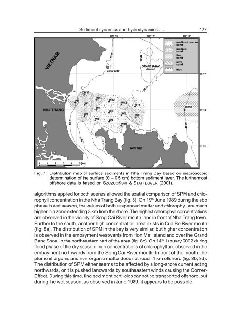
Fig. 7: Distribution map of surface sediments in Nha Trang Bay based on macroscopic<br />
determination of the surface (0 – 0.5 cm) bottom sediment layer. The furthermost<br />
offshore data is based on SZCZUCIÑSKI & STATTEGGER (2001).<br />
algorithms applied for both scenes allowed the spatial comparison of SPM and chlorophyll<br />
concentration in the Nha Trang Bay (fig. 8). On 19 th June 1989 during the ebb<br />
phase in wet season, the values of both suspended matter and chlorophyll are much<br />
higher in a zone extending 3 km from the shore. The highest chlorophyll concentrations<br />
are observed in the vicinity of Song Cai River mouth, and in front of Nha Trang town.<br />
Further to the south, another high concentration area exists in Cua Be River mouth<br />
(fig. 8a). The distribution of SPM in the bay is very similar, but higher concentration<br />
is observed in the embayment westwards from Hon Mat Island and over the Grand<br />
Banc Shoal in the northeastern part of the area (fig. 8c). On 14 th January 2002 during<br />
flood phase of the dry season, high concentrations of chlorophyll are observed in the<br />
embayment northwards from the Song Cai River mouth. In front of the mouth, the<br />
plume of organic and non-organic matter does not reach 1 km offshore (fig. 8b, 8d).<br />
The distribution of SPM either seems to be affected by a long-shore current acting<br />
northwards, or it is pushed landwards by southeastern winds causing the Corner-<br />
Effect. During this time, fine sediment parti-cles cannot be transported offshore, but<br />
during the wet season, as observed in June 1989, it appears to be possible.