Geological Excursion Guide to Iceland
Geological Excursion Guide to Iceland
Geological Excursion Guide to Iceland

Create successful ePaper yourself
Turn your PDF publications into a flip-book with our unique Google optimized e-Paper software.
Thordarson Chapman 2012 1<br />
Field <strong>Guide</strong> for Þingvellir<br />
Chapman Conference 2012<br />
by<br />
Thor Thordarson<br />
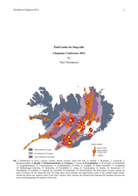
Fig. 1 Distribution of active volcanic systems among volcanic zones and belts in <strong>Iceland</strong>: 1. Reykjanes, 2. Krýsuvík, 3.<br />
Brennisteinsfjöll, 4. Hengill, 5. Hróðmundartindur, 6. Grímsnes, 7. Geysir, 8. Prestahnjúkur, 9. Hveravellir, 10. Hofsjökull,<br />
11. Tungnafellsjökull, 12, Vestmannaeyjar, 13. Eyjafjallajökull, 14. Katla, 15. Tindfjöll, 16. Hekla-Vatnafjöll, 17. Torfajökull,<br />
18. Bárðarbunga-Veiðivötn, 19. Grímsvötn, 20. Kverkfjöll, 21. Askja, 22. Fremrinámur, 23. Krafla, 24. Þeistareykir, 25.<br />
Öræfajökull, 26. Esjufjöll, 27. Snæfell, 28. Ljósufjöll, 29. Helgrindur, 30. Snæfellsjökull. The bold fonted volcanic systems are<br />
those of interest for the Þingvellir trip. The large open circle indicates the approximate centre of the <strong>Iceland</strong> mantle plume.<br />
Dotted line shows the northern limits of the East Volcanic Zone, whereas the hachured line indicates the boundary between the<br />
active and propagating rift segments of the zone.
Thordarson Chapman 2012 2<br />
USEFUL MAPS OF SOUTH ICELAND<br />
Fig. 2. The main geological features of South <strong>Iceland</strong>.<br />
Fig. 3. Distribution of lowland areas invaded by the sea <strong>to</strong>wards the very end of the Weichselian glaciation.
Thordarson Chapman 2012 3<br />
Þingvellir <strong>Excursion</strong><br />
No trip <strong>to</strong> <strong>Iceland</strong> is complete without a visit <strong>to</strong> the national park at Þingvellir. This his<strong>to</strong>rical site offers not only superb<br />
geology but also a glimpse in<strong>to</strong> <strong>Iceland</strong>’s his<strong>to</strong>ry. Þingvellir is the original site of the Alþing, the general assembly of<br />
the <strong>Iceland</strong>ic commonwealth (930-1262). It was established in 930 and is still operation <strong>to</strong>day, making it the Europe’s<br />
oldest operating parliament. In the days of the commonwealth, each year the chieftains and their followers gathered at<br />
Þingvellir <strong>to</strong> settle their debates. The laws of the land were recited by the law speaker from Lögberg – a natural pedestal<br />
made of lava – using the walls of Almannagjá<strong>to</strong> echo is words over the constituency.<br />
Þingvellir is truly the heart of <strong>Iceland</strong>ic culture and it has been the venue for some of the most significant events in the<br />
country’s his<strong>to</strong>ry, perhaps none as significant as the nationwide adoption of Christianity in the year 1000, which came<br />
about through political debate at the Alþing. The main reason appears <strong>to</strong> be that majority wanted <strong>to</strong> maintain peace and<br />
unity throughout the nation and <strong>to</strong> prevent civil war between the extremists within opposing factions, the followers of<br />
the old heathen religion and Christians. The records of the event also offer a rare indication of the contemporary<br />
understanding of volcanic eruptions.<br />
As the members of the Alþing were debating the adoption of Christianity, news was brought of an eruption in the<br />
Ölfusdistrict, south <strong>Iceland</strong>. It was apparent that the lava flow would overrun the farm of the heathen priest Þóroddur<br />
and the extremists among the heathen followers spoke: "We are not amazed that the heathen gods are enraged at such a<br />
decision." Then the heathen chieftain Snorri replied: "At what were the gods enraged when the lava on which we are<br />
now standing was formed?" According <strong>to</strong> the chronicles, this reply was the turning point in the debate and ended the<br />
protest by the heathen extremists. It also shows that volcanic eruptions were generally viewed as phenomena of nature<br />
rather than punishment from higher authorities. For further information on the other his<strong>to</strong>rical aspects of Þingvellir,<br />
there is an information centre at the park entrance.<br />
Viewing the Þingvellir area from the main lookout (Fig. 12: locality 1), it becomes clear in an instant that the geology of<br />
the area is one of seafloor spreading, displaying the intricate association of crustal rifting and volcanism within the West<br />
Volcanic Zone. The bedrock in the area consists of Holocene basalt lavas covering the central part of the fault-bounded<br />
lake basin (i.e. the Þingvellir graben) and Pleis<strong>to</strong>cene pillow lavas and hyaloclastites, forming the móberg ridges and<br />
table mountains aligned along the periphery of the basin. The Þingvellir graben is completely circumscribed on all sides<br />
by volcanoes that belong <strong>to</strong> four active volcanic systems, the Prestahnúkur and Hrafnabjörg systems <strong>to</strong> the north and<br />
the Hengill and Hrómundartindur systems <strong>to</strong> the south (Fig. 5).<br />
Starting in the north, the first in view is the strongly faulted Ármannsfell mountain, which was formed by a subglacial<br />
eruption that broke through the Weichselian glacier <strong>to</strong> form a table mountain composed of strongly olivine phyric basalt<br />
(Fig. 12). Behind Ármannsfell <strong>to</strong> the right is Skjaldbreiður, the pro<strong>to</strong>type of monogenetic lava shields. Exhibiting a<br />
perfect shield shape, the volcano has a basal diameter of 16-18 km and stretches right across the northern end of the<br />
Þingvellir graben. It is characterised by gently rising (1-8) outer slopes climbing from 350 m at the base <strong>to</strong> 1000 m at<br />
the summit. The Skjaldbreiður volcano was constructed by a long-lived effusive eruption that probably lasted for 50-<br />
100 years and its lavas have a <strong>to</strong>tal volume of 17 km 3 .<br />
To the east on the edge of the graben are the subglacial volcanoes Hrafnabjörg and Tindaskagi, displaying the classical<br />
forms of a table mountain and a móberg ridge, respectively. Further east in the background are the mountains of the<br />
Laugarvatn region, where J. G. Jones established the characteristic facies associations for subglacial volcanoes in his<br />
classic studies during the 1970’s.<br />
The extensive pahoehoe lava-flow fields that fill in the graben in front of Skjaldbreiður and Ármannsfell were largely<br />
formed by effusive eruptions within the Hrafnabjörg volcanic system in the early Holocene. One is the eruption that<br />
constructed the Skjaldbreiður volcano, whereas the other three originated from relatively short fissures <strong>to</strong> the east of<br />
Hrafnabjörg mountain (Fig. 12). Three of these lavas were formed in a major volcanic episode around 9000 years ago,<br />
issuing 30 km 3 of lava in<strong>to</strong> the Þingvellir graben.<br />
The first <strong>to</strong> form was the Þingvellir lava (C 14 age = 9130 260 years) that now floors the northern half of Lake<br />
Þingvallavatn and the area immediately <strong>to</strong> the north and east of the lake, and originated from volcanic fissures <strong>to</strong> the<br />
southeast of Hrafnabjörg. The flows of this lava are exposed in the fault scarp at Almannagjá, where they exhibit the<br />
classical structure of inflated pahoehoe lobes. Model calculations show that it <strong>to</strong>ok more than one year <strong>to</strong> accumulate<br />
the vertical thickness of the succession exposed at Almannagjá. Every level in the succession consists of a series of<br />
laterally arranged sheet-like lava lobes, each formed by successive breakouts from an earlier formed lobe, so it is<br />
obvious that the Þingvellir lava was formed by a long-lived eruption that may have lasted for decades. This activity was<br />
closely followed by the Skjaldbreiður lava-shield eruption, which, in addition <strong>to</strong> constructing the lava shield in the<br />
northern part of the graben, sent lavas southwards that partly covered the existing Þingvellir lava. This episode<br />
culminated with the Eldborgir fissure eruption, which produced the rubbly surface flows that cover the eastern part of<br />
the Þingvellir lava. These eruptions had a major impact on the evolution of Lake Þingvallavatn, because they reduced<br />
its size and changed its hydrological character. The youngest lava, Þjófahraun, was formed by a fissure eruption some<br />
2000-3000 years later.
Thordarson Chapman 2012 4<br />
To the east the Þingvellir graben is bordered by the interglacial (Eemian) Lyngdalsheiði lava shield and closed off <strong>to</strong> the<br />
south by the jagged mountains that make up the Hrómundartindur and Hengill central volcanoes, which were largely<br />
constructed by repeated subglacial centralised eruptions during the Weichselian glaciation (Fig. 12). The irregular form<br />
of these central volcanoes is a good example of how subglacial volcanism can modify the shape of such volcanoes. The<br />
Hrómundartindur volcano has produced the most basic and the most evolved rocks in the Þingvellir area, namely the<br />
picritic pillow basalts of Mælifell and the andesites of Stapafell. Both central volcanoes are very much alive, as is<br />
clearly indicated by occurrence of Holocene eruptions and the many hot springs and fumaroles venting the hightemperature<br />
geothermal systems of each volcano at Nesjavellir and Ölkelduháls, respectively.<br />
The Tjarnahnúkur scoria cone, a parasitic vent on the Hrómundartindur volcano, erupted in the early Holocene (> 9000<br />
years ago) <strong>to</strong> form small basaltic pahoehoe lava, which reached the shores of a proglacial lake that marks the embryonic<br />
stage of Lake Þingvallavatn (Fig. 14). During the Holocene, four small fissure eruptions have occurred within the<br />
Hengill volcanic system, with vent sites on the north flanks of the volcano. The youngest and the most prominent one<br />
was the 1900-year-old eruption that formed the Nesjahraun lava and the doubled-crater tuff cone of Sandey, the island<br />
in the lake. The Sandey cone is the hydromagmatic phase of the Nesjahraun eruption and the only eruption known<br />
within the boundaries of Lake Þingvallavatn.<br />
The prominent feature of the area is the spectacular north northeast-trending Þingvellir graben nested within the<br />
northern limb of the fissure swarm of the Hengill volcanic system. The Þingvellir graben is 10-20 km wide, narrowing<br />
<strong>to</strong> the southwest, and is bounded by a series of normal faults on either side, the main ones being Almannagjá in the west<br />
and Hrafnagjá <strong>to</strong> the east. The graben floor is sloping <strong>to</strong> the southwest, reaching 600 m altitude around the<br />
Skjaldbreiður lava shield and dropping below sea level at Lake Þingvallavatn.<br />
Perhaps the most dramatic structure at Þingvellir is the giant crack of Almannagjá, where the ground has simply been<br />
ripped by the forces of seafloor spreading. Almannagjá is 7.7 km long, and its greatest width is 64 m and its maximum<br />
throw is 30-40 m. The opposing boundary fault, Hrafnagjá, is 11 km-long, widest at 68 m and has a maximum throw of<br />
30 m. These and other boundary faults of the Þingvellir graben are thought be the surface expression of deep-rooted<br />
normal faults that extend through the crust, formed as the result of sea-floor spreading. Within the Þingvellir graben are<br />
open fissures revealing rifting of the crust.<br />
During the last 9000 years the graben floor has subsided some 40m (averaging about 1 mm/year) between Almannagjá<br />
and Hrafnagjá and the estimated horizontal extension is of the order of 70 m (averaging about 7 mm/year). Rifting<br />
within the graben is episodic and individual episodes and these tec<strong>to</strong>nic events are associated with vertical and<br />
horizontal movements on the order of several meters. The most recent rifting episode occurred in 1789, when the<br />
graben floor subsided 1-3 m, with the consequence that the old parliament flats became unusable as a venue for the<br />
annual assembly of the Alþing. Since then the Alþing has resided in Reykjavík.<br />
Þingvallavatn, the largest lake in <strong>Iceland</strong>, covers 82 km 2 and fills the deepest part of the graben, with a maximum depth<br />
of 114 m it descents <strong>to</strong> 10 m below sea level. The present-day Þingvallavatn began <strong>to</strong> form about 9700 years ago as a<br />
proglacial lake in front of the retreating Weichselian glacier (Fig. 14). As the glacier retreated farther, glacial rivers<br />
emanating from glaciers in the Langjökull area discharged in<strong>to</strong> the basin and consequently the lake grew <strong>to</strong> a size<br />
approximately equal that of its present extent. The eruptions of the 9000-year-old Þingvellir–Skjaldbreiður–Eldborgir<br />
lavas had a profound impact on the hydrological character of the Þingvellir graben because they effectively terminated<br />
the surface flow of glacial rivers from the north and reduced the lake size by more than 50% (Fig. 14). Ever since, the<br />
glacial melt water discharging from the southern end of Langjökull has percolated through the porous lava formations,<br />
undergoing a natural filtering in the process, before discharging as freshwater springs in<strong>to</strong> the lake. As a result of this<br />
continuous groundwater-driven discharge and ongoing subsidence of the graben floor over the last 9000 years, the lake<br />
as gradually grown <strong>to</strong> reach its current size.
Thordarson Chapman 2012 5<br />
Fig. 3 The development of Lake Þingvallavatn during the Holocene: Lake A is the proglacial lake stage formed as the late<br />
Weichselian glacier retreated from its maximum stand in early Preboreal times; Lake B inferred extent of the lake at about 9000<br />
years ago when the northern part of the Þingvellir graben was flooded by the voluminous Þingvellir–Skjaldbreiður–Eldborgir lava<br />
flows, changing it <strong>to</strong> a spring-fed lake. Over the last 9000 years the lake has gradually grown in size because of consistent subsidence<br />
within the graben and the present extent of Þingvallavatn is indicated by the heavy solid line.
Thordarson Chapman 2012 6<br />
A.<br />
B.<br />
C.<br />
D.<br />
Fig. 3. Another version. The development of Lake Þingvallavatn during the Holocene: A is the proglacial lake stage formed as the<br />
late Weichselian glacier retreated from its maximum stand in early Preboreal times; B Pre-9000 years lake. C. inferred extent of the<br />
lake at about 9000 years ago when the northern part of the Þingvellir graben was flooded by the voluminous Þingvellir–<br />
Skjaldbreiður–Eldborgir lava flows, changing it <strong>to</strong> a spring-fed lake. D. Over the last 9000 years the lake has gradually grown in size<br />
because of consistent subsidence within the graben and the present extent of Þingvallavatn is indicated by the heavy solid line.