RESUME J. Ronald Eastman - Clark University
RESUME J. Ronald Eastman - Clark University
RESUME J. Ronald Eastman - Clark University
Create successful ePaper yourself
Turn your PDF publications into a flip-book with our unique Google optimized e-Paper software.
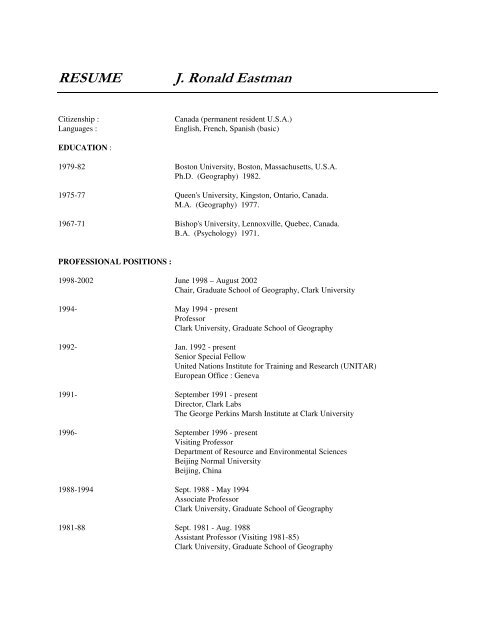
<strong>RESUME</strong><br />
J. <strong>Ronald</strong> <strong>Eastman</strong><br />
Citizenship :<br />
Languages :<br />
Canada (permanent resident U.S.A.)<br />
English, French, Spanish (basic)<br />
EDUCATION :<br />
1979-82 Boston <strong>University</strong>, Boston, Massachusetts, U.S.A.<br />
Ph.D. (Geography) 1982.<br />
1975-77 Queen's <strong>University</strong>, Kingston, Ontario, Canada.<br />
M.A. (Geography) 1977.<br />
1967-71 Bishop's <strong>University</strong>, Lennoxville, Quebec, Canada.<br />
B.A. (Psychology) 1971.<br />
PROFESSIONAL POSITIONS :<br />
1998-2002 June 1998 – August 2002<br />
Chair, Graduate School of Geography, <strong>Clark</strong> <strong>University</strong><br />
1994- May 1994 - present<br />
Professor<br />
<strong>Clark</strong> <strong>University</strong>, Graduate School of Geography<br />
1992- Jan. 1992 - present<br />
Senior Special Fellow<br />
United Nations Institute for Training and Research (UNITAR)<br />
European Office : Geneva<br />
1991- September 1991 - present<br />
Director, <strong>Clark</strong> Labs<br />
The George Perkins Marsh Institute at <strong>Clark</strong> <strong>University</strong><br />
1996- September 1996 - present<br />
Visiting Professor<br />
Department of Resource and Environmental Sciences<br />
Beijing Normal <strong>University</strong><br />
Beijing, China<br />
1988-1994 Sept. 1988 - May 1994<br />
Associate Professor<br />
<strong>Clark</strong> <strong>University</strong>, Graduate School of Geography<br />
1981-88 Sept. 1981 - Aug. 1988<br />
Assistant Professor (Visiting 1981-85)<br />
<strong>Clark</strong> <strong>University</strong>, Graduate School of Geography
1981 Jan. 1981 - April 1981<br />
Lecturer<br />
Boston <strong>University</strong>, Department of Geography.<br />
PAPERS AND PUBLICATIONS :<br />
Published Articles, Chapters, Monographs and Published Software<br />
Li, Z., and <strong>Eastman</strong>, J.R., (2006) “Commitment and Typicality Measurements for Fuzzy ARTMAP Neural<br />
Network”, Proceedings of SPIE -- The International Society for Optical Engineering, Volume 6420<br />
Geoinformatics 2006: Geospatial Information Science, Jianya Gong, Jingxiong Zhang, Editors, 64201I-2.<br />
Vester, H.F.M., Lawrence, D., <strong>Eastman</strong>, J.R., Turner, B.L. II, Calme, S., Dickson, R., Pozo, C., Sangermano, F., (in<br />
press) Land Change in the Southern Yucatán and Calakmul Biosphere Reserve: Implications for Habitat and<br />
Biodiversity, Ecological Applications.<br />
Lippitt, C.D., Rogan, J., Toledano, J., Sangermano, F., <strong>Eastman</strong>, J.R., Mastro, V., and Sawyer, A. (submitted,<br />
Ecological Modeling) “Incorporating Anthropogenic Variables into a Species Distribution Model to<br />
Estimate the Risk of Gypsy Moth Establishment in Uninfested Portions of the United States”.<br />
<strong>Eastman</strong>, J.R., Schmook, B., Dickson, R.P., Sangermano, F., Vadjunec (submitted, International Journal of Remote<br />
Sensing) A Step-Wise Land Cover Classification of the Tropical Forests of the Southern Yucatan, Mexico.<br />
<strong>Eastman</strong>, J.R., (2006) IDRISI 15.0 : The Andes Edition (Worcester MA: <strong>Clark</strong> <strong>University</strong>).<br />
Li, Z., <strong>Eastman</strong>, J.R., (2006) The Nature and Classification of Unlabelled Neurons in the Use of Kohenon’s Self-<br />
Organizing Map for Supervised Classification, Transactions in GIS, 10, 4, 599-613.<br />
<strong>Eastman</strong>, J.R., Van Fossen, M. E. and Solorzano, L.A., (2005) “Transition Potential Modeling for Land Cover<br />
Change”, Chapter 17 in GIS, Spatial Analysis and Modeling, D. Maguire, M. Batty, and M. Goodchild,<br />
eds., (Redlands, California : ESRI Press), 357-386.<br />
<strong>Eastman</strong>, J.R., Toledano, J., Crema, S., Zhu, H., and Jiang, H., (2005) “In-Process Classification Assessment of<br />
Remotely Sensed Imagery”, GeoCarto International, 20, 4, 33-44.<br />
D. Lawrence, H. Vester, D. Pérez-Salicrup, R. <strong>Eastman</strong>, B. L. Turner II, and J. Geoghegan. (2003) Integrated<br />
Analysis of Ecosystem Interactions with Land-Use Change: The Southern Yucatán Peninsular Region. In<br />
Ecosystem Interactions with Land Use Change, G. Asner and R. DeFries, eds., Geophysical Monograph<br />
Series 153, 277-292 (Washington, D.C.: American Geophysical Union).<br />
<strong>Eastman</strong>, J.R., (2003) IDRISI : The Kilimanjaro Edition (Worcester MA: <strong>Clark</strong> <strong>University</strong>).<br />
<strong>Eastman</strong>, J.R., and Laney, R., (2002) "Bayesian Soft Classification for Sub-Pixel Analysis: A Critical Evaluation,"<br />
Photogrammetric Engineering and Remote Sensing, 68, 11, 1149-1154.<br />
<strong>Eastman</strong>, J.R., Jiang, H., Zhu, H., Crema, S. and Toledano, J., (2002) “In-Process Classification Assessment (IPCA)<br />
using a Dempster-Shafer Decomposition of Classification Uncertainty”, Proceedings, 29 th International<br />
Symposium on Remote Sensing of the Environment, Buenos Aires, April 8-12, 2000.<br />
<strong>Eastman</strong>, J.R., (2002) “Analyzing Motion with Trend Surface Analysis”, Analytical Notes, 1, www.clarklabs.org.<br />
Haan, N., Gumbo, D., <strong>Eastman</strong>, R., Toledano, J., and Snel, M., (2002) Linking Geomatics and Participatory Social<br />
Analysis for Environmental Monitoring—Case Studies from Malawi, Cartographica, 37, 4, 21-32.
<strong>Eastman</strong>, J.R., (2001) "Uncertainty Management in GIS: Decision Support Tools for Effective Use of Spatial Data ",<br />
Chapter 18 in Hunsaker, C., Goodchild, M., Friedl, M., and Case, E., eds, Spatial Uncertainty in Ecology:<br />
Implications for Remote Sensing and GIS Applications, (NY : Springer-Verlag), 379-390.<br />
Anyamba, A., Tucker, C.J., and <strong>Eastman</strong>, J.R., (2001) "NDVI Anomaly Patterns over Africa during the 1997/98<br />
ENSO Warm Event", International Journal of Remote Sensing, 22, 10, 1847-1859.<br />
<strong>Eastman</strong>, J.R., (2001) “The Evolution of Modeling Tools in GIS”, Directions Magazine, July 2001, (on-line<br />
magazine (www.directionsmag.com).<br />
Zhu, H., <strong>Eastman</strong>, J.R., and Toledano, J., (2001) "Triangulated Irregular Network Optimization from Countour Data<br />
using Bridge and Tunnel Edge Removal", International Journal of Geographical Information Science, 15,<br />
3, 271-286.<br />
<strong>Eastman</strong>, J.R., (2001) IDRISI32 : IDRISI for Workstations, Release 2 (Worcester MA: <strong>Clark</strong> <strong>University</strong>).<br />
<strong>Eastman</strong>, J.R., (2000) “Managing Uncertainty for Effective Use of Data in GIS”, Proceedings, GISDECO IV.<br />
<strong>Eastman</strong>, J.R., (2000) “Decision Strategies in GIS”, Directions Magazine, December 2000 (on-line magazine<br />
(www.directionsmag.com).<br />
Toledano, J., Gumbo, D., and <strong>Eastman</strong>, J.R., (2000) "Linking National Geographical Information Systems Analysis<br />
and Local Social Analysis for Effective Environmental Management", Proceedings, 28th International<br />
Symposium on Remote Sensing of the Environment, Cape Town, South Africa, March 27-31, 51-54.<br />
Gumbo, D., <strong>Eastman</strong>, J.R., Toledano, J., Snel, M., and Haan, N., (2000) "It Takes a Village : Assessing Social<br />
Causes of Environmental Change in Africa", GeoInfo Systems, 10, 1, 22-27.<br />
Jiang, H., and <strong>Eastman</strong>, J.R., (2000) "Application of Fuzzy Measures in Multi-Criteria Evaluation in GIS",<br />
International Journal of Geographical Information Science, 14, 2, 173-184.<br />
<strong>Eastman</strong>, J.R., (1999) "Multi-criteria evaluation and GIS", Chap. 35 in Geographical Information Systems, Longley,<br />
P.A., Goodchild, M.F., Maguire, D.J., and Rhind, D.W., eds., (New York : John Wiley and Sons), 493-502.<br />
<strong>Eastman</strong>, J.R., (1999) IDRISI32 : IDRISI for Workstations, [Version 3.0] (Worcester MA: <strong>Clark</strong> <strong>University</strong>)<br />
Hagan, J., <strong>Eastman</strong>, J.R., Auble, J., (1999) CartaLinx, Version 1.2 (Worcester MA: <strong>Clark</strong> <strong>University</strong>)<br />
Zhu, H., <strong>Eastman</strong>, J.R., Schneider, K., (1999) "Constrained Delaunay Triangulation and Tin Optimization using<br />
Contour Data", Proceedings, Thirteenth International Conference on Applied Geologic Remote Sensing,<br />
Vancouver BC, Canada, March 1-3, 1999, II-373 - II-380.<br />
<strong>Eastman</strong>, J.R., Jiang, H., Toledano, J., (1998) "Multi-Criteria and Multi-Objective Decision Making for Land<br />
Allocation using GIS", in Euro Beinat and Peter Nijkamp, eds., Multi-Criteria Analysis for Land-use<br />
Management, Environment and Management Vol. 9. (Dordrecht, Netherlands: Kluwer Academic<br />
Publishers), 227-251.<br />
<strong>Eastman</strong>, J.R., (1998) "Uncertainty Management for Decision Support in GIS: New Tools for Effective Use of Data<br />
Resources" Proceedings, UNDP Regional Conference on Poverty-Related Core Data Needs for the Asia-<br />
Pacific Region, Kuala Lumpur, Malaysia , May 6-8, 1998, 156-161.<br />
Anyamba, A., <strong>Eastman</strong>, J.R., Ramachandran, M., (1998) The <strong>Clark</strong> Labs ENSO Monitor, Southern Africa Report,<br />
Volume 1, Number 7, March 1998, (www.idrisi.clarku.edu/10applic/assaf1/monitfront.htm).
Anyamba, A., <strong>Eastman</strong>, J.R., Ramachandran, M., (1998) The <strong>Clark</strong> Labs ENSO Monitor, Southern Africa Report,<br />
Volume 1, Number 6, January 1998, (www.idrisi.clarku.edu/10applic/assaf1/monitfront.htm).<br />
Hagan, J., <strong>Eastman</strong>, J.R., Auble, J., (1998) CartaLinx, Version 1.0 (Worcester MA: <strong>Clark</strong> <strong>University</strong>)<br />
Foresman, T.W., Cary, T., Shupin, T., <strong>Eastman</strong>, R., Estes, J.E., Faust, N., Jensen, J.R., and Kemp, K.K., (1997)<br />
"Internet teaching foundation for the Remote Sensing Core Curriculum program", ISPRS Journal of<br />
Photogrammetry and Remote Sensing, 52, 294-300.<br />
Anyamba, A., <strong>Eastman</strong>, J.R., Ramachandran, M., (1997) The <strong>Clark</strong> Labs ENSO Monitor, Southern Africa Report,<br />
Volume 1, Number 5, December 1997, (www.idrisi.clarku.edu/10applic/assaf1/monitfront.htm).<br />
Anyamba, A., <strong>Eastman</strong>, J.R., Ramachandran, M., (1997) The <strong>Clark</strong> Labs ENSO Monitor, Southern Africa Report,<br />
Volume 1, Number 4, November 1997, (www.idrisi.clarku.edu/10applic/assaf1/monitfront.htm).<br />
Anyamba, A., <strong>Eastman</strong>, J.R., Ramachandran, M., (1997) The <strong>Clark</strong> Labs ENSO Monitor, Southern Africa Report,<br />
Volume 1, Number 3, October 1997, (www.idrisi.clarku.edu/10applic/assaf1/monitfront.htm).<br />
Anyamba, A., <strong>Eastman</strong>, J.R., Ramachandran, M., (1997) The <strong>Clark</strong> Labs ENSO Monitor, Southern Africa Report,<br />
Volume 1, Number 2, September 1997, (www.idrisi.clarku.edu/10applic/assaf1/monitfront.htm).<br />
Anyamba, A., <strong>Eastman</strong>, J.R., Ramachandran, M., (1997) The <strong>Clark</strong> Labs ENSO Monitor, Southern Africa Report,<br />
Volume 1, Number 1, August 1997, (www.idrisi.clarku.edu/10applic/assaf1/monitfront.htm).<br />
<strong>Eastman</strong>, J.R., Anyamba, A., (1997) "The Spatial Manifestation of ENSO-related Drought and Drought Precursors in<br />
Southern Africa", Proceedings, Fifth International Conference on Southern Hemisphere Meteorology and<br />
Oceanography, 336-337, Pretoria, South Africa, April 7-11, 1997.<br />
Anyamba, A., <strong>Eastman</strong>, J.R., (1997) "Time-Space Examination of ENSO-related Patterns from Vegetation Index<br />
Time Series for Africa", Proceedings, Fifth International Conference on Southern Hemisphere<br />
Meteorology and Oceanography, 338-339, Pretoria, South Africa, April 7-11, 1997.<br />
Jiang, H., and <strong>Eastman</strong>, J.R., (1997) "Application of Fuzzy Measures in Multi-Criteria Evaluation in GIS",<br />
Proceedings, 13th International Conference on Multiple Criteria Decision Making, Jan. 6-10, 1997, Cape<br />
Town, South Africa.<br />
<strong>Eastman</strong>, J.R., Emani, S., Hulina, S., Jiang, H., Johnson, A., Ramachandran, M., (1997) Applications of Geographic<br />
Information Systems (GIS) Technology in Environmental Risk Assessment and Management, (UNEP,<br />
Division of Environmental Information and Assessment, Sioux Falls, SD).<br />
<strong>Eastman</strong>, J.R., Gold, S., (1997) "Assessing the Impacts of Sea-Level Rise in Vietnam", GeoInfo Systems, 7, 1, 38-43.<br />
<strong>Eastman</strong>, J.R., (1997) IDRISI for Windows, Version 2.0 (Worcester MA: <strong>Clark</strong> <strong>University</strong>)<br />
Ramachandran, M., <strong>Eastman</strong>, J.R., (1996) "Decision Making Techniques for Vulnerability Analysis: A West Africa<br />
Food Security Case Study", Proceedings, GIS/LIS'96, 964-974.<br />
Jiang, H., <strong>Eastman</strong>, J.R., (1996) "Applications of Fuzzy Measures in Multi-Criteria Evaluation", Proceedings,<br />
Chinese Association of GIS, 2nd Annual Meeting, 474-478.<br />
<strong>Eastman</strong>, J.R., Anyamba, A., (1996) "Prototypical Patterns of ENSO-related Drought and Drought Precusors in<br />
Southern Africa", Proceedings, Pecora 13, 438-446.<br />
<strong>Eastman</strong>, J.R., Toledano, J., (1996) "Forest Monitoring in Malawi", Earth Observation Magazine, 5, 9, 28-31.
<strong>Eastman</strong>, J.R., (1996) "GIS and Uncertainty Management : New Directions in Software Development", Proceedings,<br />
Spanish Association of Geographers.<br />
<strong>Eastman</strong>, J.R., Jiang, H., (1996) "Fuzzy Measures in Multi-Criteria Evaluation", Proceedings, Second International<br />
Symposium on Spatial Accuracy Assessment in Natural Resources and Environmental Studies, May 21-23,<br />
Fort Collins, Colorado, 527-534.<br />
<strong>Eastman</strong>, J.R., (1996) "Global Vegetation Index Time Series Image Data and the Analysis of Ecosystem Dynamics",<br />
Proceedings, Ecological Resource Monitoring: Change and Trend Detection, ASA/ESA/EPA, Laurel MD,<br />
May 1-3 [in press]<br />
<strong>Eastman</strong>, J.R., Toledano, J., (1996) "An Ecological Strategy for Sustainable GIS Technology Transfer", EIS News,<br />
July 1966, World Bank Secretariat of the Program on Environmental Information Systems.<br />
<strong>Eastman</strong>, J.R., (1996) "Uncertainty and Decision Risk in Multi-Criteria Evaluation: Implications for GIS Software<br />
Design", Proceedings, International Institute for Software Technology Expert Group Workshop on<br />
Software Technology for Agenda'21 : Decision Support Systems. Section 8.<br />
<strong>Eastman</strong>, J.R., Anyamba, A., Ramachandran, M., (1996) "The Spatial Manifestation of ENSO in Southern Africa",<br />
Proceedings, Conference on the Application of Remotely Sensed Data and Geographic Information<br />
Systems in Environmental and Natural Resources Assessment in Africa, Harare, March 15-22, 269-281.<br />
Anyamba, A., <strong>Eastman</strong>, J.R., (1996) "Interannual Variability of NDVI over Africa and its relation to El Niño /<br />
Southern Oscillation". International Journal of Remote Sensing 17(13) : 2533-2548.<br />
<strong>Eastman</strong>, J.R., Toledano, J., Hutchinson, C., (in press) GIS and Image Processing in Environmental Management<br />
and Research. Volume 1 : An Introduction to GIS and Image Processing (Nairobi : UNEP).<br />
<strong>Eastman</strong>, J.R., Jiang, H., (1995) "Uncertainty Metadata and GIS Software System Design", Proceedings,<br />
GISDATA'95 [in press]<br />
<strong>Eastman</strong>, J.R., (1995) IDRISI for Windows, Version 1.0 (Worcester MA: <strong>Clark</strong> <strong>University</strong>)<br />
Anyamba, A., <strong>Eastman</strong>, J.R., Fulk, M., (1995) "NDVI Image Time Series as an Indicator of Climate Variability",<br />
Proceedings, ACSM/ASPRS Technical Papers, 3, 714-723.<br />
<strong>Eastman</strong>, J.R., Jin, W., Kyem, P.A.K., Toledano, J., (1995) "Raster Procedures for Multi-Criteria/Multi-Objective<br />
Decisions", Photogrammetric Engineering and Remote Sensing. 61, 5, 539-547.<br />
<strong>Eastman</strong>, J. R., Anyamba, A. and Ramachandran, M., (1995) "African Vegetation Data Support Evidence of a<br />
Developing ENSO Warm Phase". Proceedings, AFRICAGIS'95, March 4-10, 1995. Abidjan, Cote d' Ivoire.<br />
Estes, J., Star, J., Goodchild, M., Cary, T., <strong>Eastman</strong>, J.R., Faust, N., Foresman, T., Jensen J., Shupin, A., (1993)<br />
"The NCGIA Core Curriculum in Remote Sensing", Photogrammetric Engineering and Remote Sensing,<br />
59, 6, 945-948.<br />
<strong>Eastman</strong>, J.R., Toledano, J., Jin, W., Kyem, P.A.K., (1993) Participatory Multi-Objective Decision Making in GIS,<br />
Proceedings, AUTOCARTO XI, 33-42.<br />
<strong>Eastman</strong>, J.R., (1993) IDRISI, Version 4.1 (Worcester, MA : <strong>Clark</strong> <strong>University</strong>).<br />
<strong>Eastman</strong>, J.R., (1993) Decision Theory and GIS, Proceedings, Africa GIS'93, UNITAR/UNSO/SSO, 45-64.<br />
<strong>Eastman</strong>, J.R., Jin, W., Kyem, P.A.K., Toledano, J., (1993) "An Algorithm for Multi-Objective Land Allocation<br />
Using GIS", Proceedings, International Workshop on GIS'93, Beijing, August, 261-270.
<strong>Eastman</strong>, J.R., and Fulk, M., (1993) "Long Sequence Time Series Evaluation using Standardized Principal<br />
Components", Photogrammetric Engineering and Remote Sensing, 59, 8, 1307-1312.<br />
<strong>Eastman</strong>, J.R., (1993) "Models of Space", The European Government Journal, 75-78.<br />
<strong>Eastman</strong>, J.R., Hutchinson, C., Toledano, J,. Fulk, M., (1993) Handbook on GIS (Washington : USAID).<br />
<strong>Eastman</strong>, J.R., and Fulk, M., (1993) "Time Series Analysis of Remotely Sensed Data using Standardized Principal<br />
Components", Proceedings, ERIM/CIESIN International Symposium on Remote Sensing, Graz, Austria,<br />
April 1993, Vol. I, 485-496.<br />
<strong>Eastman</strong>, J.R., Kyem, P.A.K., Toledano, J., (1993) "A Procedure for Multi-Objective Decision Making in GIS<br />
Under Conditions of Competing Objectives", Proceedings, EGIS'93, 438-447.<br />
<strong>Eastman</strong>, J.R., Kyem, P.A.K., Toledano, J., Jin, W., (1993) GIS and Decision Making (Geneva: UNITAR).<br />
<strong>Eastman</strong>, J.R., Jin, W., Kyem, P.A.K., (1993) "Participatory Procedures for Multi-Criteria Evaluation in GIS",<br />
Proceedings of the First Symposium of Chinese Professionals in Geographic Information Systems, Buffalo,<br />
NY Aug 15-16, 1992, 281-288. [in Chinese with an English abstract]<br />
<strong>Eastman</strong>, J.R., (1992) "Time Series Map Analysis Using Standardized Principal Components", Proceedings,<br />
ASPRS/ACSM/RT 92 Convention on Monitoring and Mapping Global Change, 195-204.<br />
<strong>Eastman</strong>, J.R., (1992) IDRISI, Version 4.0 (Worcester, MA : <strong>Clark</strong> <strong>University</strong>). A grid-based geographic analysis<br />
system : GIS and Image Processing software and manual prepared for and commercially distributed by<br />
<strong>Clark</strong> <strong>University</strong>, Graduate School of Geography (2 volumes / 400 pages / 15 disks)<br />
McKendry, J., <strong>Eastman</strong>, J.R., St. Martin, K., Fulk, M., (1991) Forestry Applications of GIS, (Geneva : UNITAR).<br />
<strong>Eastman</strong>, J.R., McKendry, J., (1991) Change and Time Series Analysis in GIS, (Geneva : UNITAR).<br />
<strong>Eastman</strong>, J.R., Ford, R., Gibson, A.E., Toledano, J., (1991) An Introduction to Geographic Information Systems for<br />
Natural Resources Management, (Worcester, MA : SARSA/USAID).<br />
<strong>Eastman</strong>, J.R., (1991) "Where's the Information in GIS", ACSM Bulletin, February, 50.<br />
<strong>Eastman</strong>, J.R., Kineman, J., Dodson, R., Livingston, M., Azimi, N., (1990) Global Change Database Project, Pilot<br />
Project for Africa Workbook, (ICSU Panel on World Data Centers/IGBP : UCAR, Boulder Colorado)<br />
<strong>Eastman</strong>, J.R., (1990) IDRISI, Version 3.2 (Worcester, MA : <strong>Clark</strong> <strong>University</strong>). A grid-based geographic analysis<br />
system : GIS and Image Processing software and manual prepared for and commercially distributed by<br />
<strong>Clark</strong> <strong>University</strong>, Graduate School of Geography (356 pages / 12 disks)<br />
<strong>Eastman</strong>, J.R., (1990) "Digital Atlas/Encyclopedia Systems for the Exploration of Global Change", Proceedings,<br />
International Society for Photogrammetry and Remote Sensing Commission IV, 28, 4, 1-8.<br />
Herwitz, S.R., Peterson, D.L., <strong>Eastman</strong>, J.R., (1990) "Thematic Mapper Detection of Changes in the Leaf Area of<br />
Closed Canopy Pine Plantations in Central Massachusetts", Remote Sensing of the Environment, 29, 129-<br />
140.<br />
<strong>Eastman</strong>, J.R., (1989) IDRISI, Version 3.1 (Worcester, MA : <strong>Clark</strong> <strong>University</strong>). A grid-based geographic analysis<br />
system : GIS software and manual prepared for and commercially distributed by <strong>Clark</strong> <strong>University</strong>, Graduate<br />
School of Geography (250 pages / 10 disks)
<strong>Eastman</strong>, J.R., (1989) "Requirements of a Research System for Cartographic Modeling and Geographic Analysis",<br />
Proceedings, International Cartographic Association, 14th International Conference, Budapest, [in press<br />
(Hungarian currency problems may ultimately prohibit final publication)].<br />
<strong>Eastman</strong>, J.R., (1989) "Pushbroom Algorithms for Calculating Distances in Raster Grids", Proceedings,<br />
AUTOCARTO 9, 288-297.<br />
<strong>Eastman</strong>, J.R., (1989) "GIS Software from the Academic Sector: A Different Vision?", Proceedings, Challenge for<br />
the 1990's GIS, (Ottawa : Canadian Institute of Surveying and Mapping), 1212-1219.<br />
<strong>Eastman</strong>, J.R., (1988) IDRISI, Version 3 (Worcester, MA : <strong>Clark</strong> <strong>University</strong>). A grid-based geographic analysis<br />
system : GIS software and manual prepared for and commercially distributed by <strong>Clark</strong> <strong>University</strong>, Graduate<br />
School of Geography (220 pages / 8 disks)<br />
<strong>Eastman</strong>, J.R., (1988) "Idrisi : A Geographic Analysis System for Research Applications", The Operational<br />
Geographer, 15, 17-21.<br />
<strong>Eastman</strong>, J.R., (1987) "Access to Technology : The Design of the IDRISI Research System", Proceedings, GIS '87,<br />
166-175.<br />
<strong>Eastman</strong>, J.R., (1987) IDRISI, Version 2 (Worcester, MA : <strong>Clark</strong> <strong>University</strong>). A grid-based geographic analysis<br />
system : GIS software and manual prepared for and commercially distributed by <strong>Clark</strong> <strong>University</strong>, Graduate<br />
School of Geography (180 pages / 6 disks)<br />
<strong>Eastman</strong>, J.R., (1987) "Mapping Out a Plan of Action" -- Mapping Information Management Systems : The Long<br />
Beach Experience, Digital Review, Aug.3, 46-49.<br />
<strong>Eastman</strong>, J.R., (1987) "A Microcomputer-based Geographic Analysis System for Research Applications",<br />
Proceedings, Canadian Cartographic Association, 88-99.<br />
<strong>Eastman</strong>, J.R., (1987) "Graphic Syntax and Expert Systems for Map Design", ACSM Technical Papers, Vol. 4, 87-<br />
96.<br />
<strong>Eastman</strong>, J.R., Warren, S., (1987) "IDRISI : A Collective Geographic Analysis System Project", Proceedings,<br />
AUTOCARTO 8, 421-430.<br />
<strong>Eastman</strong>, J.R., (1987) "Remote Sensing, Automated Cartography and GIS", <strong>Clark</strong> Now, 17, 2, 10-12.<br />
<strong>Eastman</strong>, J.R., (1986) "Opponent Process Theory and Syntax for Qualitative Relationships in Quantitative Series",<br />
The American Cartographer, 13, 4, 324-333.<br />
<strong>Eastman</strong>, J.R., (1985) "Cognitive Models and Cartographic Design Research", The Cartographic Journal, 22, 2, 95-<br />
101.<br />
<strong>Eastman</strong>, J.R., (1985) "Graphic Organization and Memory Structures for Map Learning", Cartographica, 22, 1, 1-<br />
20.<br />
<strong>Eastman</strong>, J.R., (1985) "Names Placement and Positional Recall of Map Information", ACSM Technical Papers, 474-<br />
482.<br />
Castner, H.W., <strong>Eastman</strong>, J.R., (1985) "Eye Movement Parameters and Perceived Map Complexity, Part 2", The<br />
American Cartographer, 12, 1, 29-40.<br />
Castner, H.W., <strong>Eastman</strong>, J.R., (1984) "Eye Movement Parameters and Perceived Map Complexity, Part 1", The<br />
American Cartographer, 11, 2, 107-117.
<strong>Eastman</strong>, J.R., Castner, H.W., (1983) "The Role of Experience in Task-Specific Map Reading", Chap. 6 in Graphic<br />
Communication and Design in Contemporary Cartography, D.R.F. Taylor, ed., (New York : John Wiley<br />
and Sons), 115-147.<br />
<strong>Eastman</strong>, J.R., (1981) "The Perception of Scale Change in Small-Scale Map Series", The American Cartographer,<br />
Vol. 8, No. 1, 5-21.<br />
<strong>Eastman</strong>, J.R., Nelson, B., Shields, G., (1981) "Production Considerations in Isodensity Mapping", Cartographica,<br />
Vol. 18, No. 1, 24-30.<br />
Published Reviews<br />
<strong>Eastman</strong>, J.R., (1989) Review of Tactics International's FASTMAP marketing<br />
Review, Sept. 25, 35-40.<br />
geographic analysis system, Digital<br />
<strong>Eastman</strong>, J.R., (1989) Review of Computer Associates DISSPLA graphics programming software, Digitial Review,<br />
May 15, 33-38.<br />
<strong>Eastman</strong>, J.R., (1988) Review of Procyon's Star-Draw graphics generation software, Digital Review, August 15, 47-<br />
53.<br />
<strong>Eastman</strong>, J.R., (1988) Review of FTG Data Systems' EMU-TEK Seven Plus Tektronix 4107 emulation software,<br />
Digitial Review, June 6, 63-68.<br />
<strong>Eastman</strong>, J.R., (1988) Review of Ithaca Software's Hierarchical Object-Oriented Picture System, Digital Review,<br />
March 21, 41-44.<br />
<strong>Eastman</strong>, J.R., (1987) Review of the Falco 5000 graphics terminal, Digital Review, December 7, 1987, 97-99.<br />
<strong>Eastman</strong>, J.R., (1987) Review of "An Integrated Study of Desertification", by Lennart Olson, Economic Geography,<br />
[in press].<br />
<strong>Eastman</strong>, J.R., (1987) Review of Pericom's MG700 Graphics Workstation, Digital Review, June 15, 1987, 45-49.<br />
Herwitz, S., <strong>Eastman</strong>, J.R., (1987) Review of "Phytogeomorphology", by J.A. Howard and C.W. Mitchell, Annals of<br />
the Assoc. of American Geographers, 77, 1, 150-152.<br />
<strong>Eastman</strong>, J.R., (1987) Review of MicroTerm's Foresight 4560 Graphics Terminal, Digital Review, April 6, 71-73.<br />
<strong>Eastman</strong>, J.R., (1987) Review of ICEX's GRAFkit graphics programming software, Digital Review, Feb. 23, 29-32.<br />
<strong>Eastman</strong>, J.R., (1986) Review of Multiware's RENDER graphics programming software, Digital Review, Sept.29,<br />
71-73.<br />
<strong>Eastman</strong>, J.R., (1986) Review of "Semiology of Graphics", by J. Bertin, Economic Geography, 62, 1, 104-105.<br />
<strong>Eastman</strong>, J.R., (1986) Review of MBX, GSX and the Graphical Kernal System graphics programming software,<br />
Digital Review, July, 58-63.<br />
<strong>Eastman</strong>, J.R., (1985) Review of "Algorithms for Graphics and Image Processing", by T. Pavlidis, Cartographica,<br />
22, 1, 113-115.
Unpublished Conference Papers and Presentations (* = published abstract)<br />
<strong>Eastman</strong>, J.R., (2006) “Software Development for Biodiversity Conservation”, presented to the Gordon and Betty<br />
Moore Foundation, San Francisco, Nov. 2, 2006.<br />
<strong>Eastman</strong>, J.R., (2006) “The Land Change Modeler for Ecological Sustainability”, presented to the <strong>University</strong> of<br />
Redlands, Redlands Calif., ,Nov. 1, 2006.<br />
<strong>Eastman</strong>, J.R., (2006) “The Land Change Modeler for Ecological Sustainability”, presented to the American Society<br />
for Photogrammetry and Remote Sensing, New England Chapter, Worcester, Oct 2, 2006.<br />
<strong>Eastman</strong>, J.R., (2006) Range Polygon Refinement and Biodiversity Mapping using the Land Change Modeler for<br />
Ecological Sustainability”, presented to Conservation Internacional, Washington, Sept, 19, 2006.<br />
<strong>Eastman</strong>, J.R., (2006) “A GIS Modeling Environment for Land Cover Change and Habitat Assessment”, presented to<br />
the United States Regional Chapter of the International Association for Landscape Ecology Annual<br />
Symposium, San Diego, March 28-31, 2006.<br />
<strong>Eastman</strong>, J.R., (2006) “The Land Change Modeler for Ecological Sustainability”, presentation to the Association of<br />
American Geographers, Chicago, March 7-11, 2006.<br />
<strong>Eastman</strong>, J.R., and Sangermano, F., (2005) “Modelos de Distribución de Especies Utilizando Tipicalidades Standard<br />
y Ponderadas” presntation to the NatureServe Workshop Modelos de Predicción para la Distribución de<br />
Especies Andinas, Lima, Peru, September 26, 2005.<br />
<strong>Eastman</strong>, J.R., (2005) “Envisioning the Endgame: Analysis and Planning Tools for Balancing Development and<br />
Ecological Sustainability“, keynote presentation, Resource Management Tools and Geospatial Conference,<br />
Phoenix, April 18-22.<br />
<strong>Eastman</strong>, J.R., Van Fossen, M.E., and Solarzano, L.A., (2005) Developing an Integrated Modeling Enviroment for<br />
the Analysis of Land Cover and Habitat Change and Planning for Biodiversity Conservation”, presented to<br />
the AAG Annual Convention, Denver, April 5-9.<br />
<strong>Eastman</strong>, J.R., (2005) “ANDES : Analysis of Nature and Development for Ecological Sustainability”, invited lecture<br />
presented to the Centro Interamerico de Recursos del Agua (CIRA), Universidad Autonoma del Estado de<br />
Mexico, February 25.<br />
<strong>Eastman</strong>, J.R., (2004) “ANDES : Analysis of Nature and Development for Ecological Sustainability”, invited<br />
presentation, Conservation International Biodiversity Corridors Workshop, Santarem, Brazil, Dec 6-10.<br />
<strong>Eastman</strong>, J.R., (2004) "<strong>Clark</strong> Labs and the IDRISI GIS and Image Processing System" invited lecture presented to<br />
Escuela de Asuntos Ambientales, Universidad Metropolitana, San Juan, Peurto Rico. November 12, 2004.<br />
<strong>Eastman</strong>, J.R., (2004) “"Major Challenges in Developing a Modeling Environment for Land Change Science",<br />
invited lecture presented to Escuela de Asuntos Ambientales, Universidad Metropolitana, San Juan, Peurto<br />
Rico. November 11, 2004.<br />
<strong>Eastman</strong>, J.R., (2004) “Transition Potential Modeling for Land Cover Change Analysis”, invited lecture presented to<br />
the <strong>University</strong> of Brasilia, Oct. 115, 2004.<br />
<strong>Eastman</strong>, J.R., (2004) “Developing a Modeling Environment for Land Change Science”, invited lecture presented to<br />
Conservation International, Campo Grande, Brasil, Oct. 7, 2004.
<strong>Eastman</strong>, J.R., (2004) “IDRISI : Past Objectives / Future Challenges”, keynote presentation, IDRISI Latin American<br />
and Spanish Users Conference, Centro Interamerico de Recursos del Agua (CIRA), Universidad Autonoma<br />
del Estado de Mexico, June 13-15.<br />
<strong>Eastman</strong>, J.R., (2004) “Land Cover Change Modeling”, invited lecture presented to the Centro Interamerico de<br />
Recursos del Agua (CIRA), Universidad Autonoma del Estado de Mexico, March 18, 2004.<br />
<strong>Eastman</strong>, J.R., (2004) “Analytical Developments in Geographic Information Systems”, invited presentation to the<br />
National Science Foundation, in conjunction with the Association of American Geographer’s 100th<br />
Anniversary, Philadelphia, March 15, 2004.<br />
<strong>Eastman</strong>, J.R., (2003) “Research Directions and Software Development for the IDRISI System”, invited<br />
presentation to the Inter-American Workshop on HydroGeomatics, Universidad Autonoma del Estado de<br />
Mexico, Toluca, October 2003.<br />
<strong>Eastman</strong>, J.R., (2003) GIS Software Development: The Critical Role of Academic Institutions, invited lecture<br />
presented to Harvard <strong>University</strong> Graduate School of Design, March 21, 2003.<br />
<strong>Eastman</strong>, J.R., (2002) “Software Tools for Supervised Image Classification”, Workshop presented at the 29 th<br />
International Symposium on Remote Sensing of the Environment, Buenos Aires, April 7, 2002.<br />
<strong>Eastman</strong>, J.R., and Pontius, R.G., (2002) “Master of Arts in Geographic Information Science for Environment and<br />
Development:, presentated to the Association of American Geographers, Annual Meeting, March 19-23,<br />
Los Angeles, CA.<br />
<strong>Eastman</strong>, J.R., (2002) “Spatial Decision Support Systems for Sustainable Development”, invited paper presented to<br />
the National Research Council Board on Earth Sciences and Resources, Committee on the Geographic<br />
Foundation for Agenda 21, Washington, Jan. 10-11, 2002.<br />
<strong>Eastman</strong>, J.R., Toledano, J., Crema, S and Zhu, H., (2001) “In-Process Classification Assessment (IPCA) of<br />
Remotely Sensed Imagery”, Remote Sensing and Accuracy Assessment Symposium, Las Vegas Nevada,<br />
Dec 11-13.<br />
<strong>Eastman</strong>, J.R., (2001) “Effective Use of Data through Uncertainty Management”, keynote presentation to AfricaGIS<br />
2001, Nairobi, Kenya, Nov. 5-9.<br />
<strong>Eastman</strong>, J.R., and Anyamba, A., (2001) “Spatial prediction of growing season characteristics based on time series<br />
image analysis”, paper presented to USAID/FEWS and NASA, NASA Goddard Space Flight Center,<br />
September 6, 2001.<br />
<strong>Eastman</strong>, J.R., (2001) “GIS, Decision Science and the Analysis of Landscape Change”, keynote address (invited),<br />
Workshop on Landscape Change, National Center for Geographic Information and Analysis, Santa<br />
Barbara, January 25-27, 2001.<br />
<strong>Eastman</strong>, J.R., (2000) “Managing Uncertainty for Effective Use of Data in GIS”, keynote address (invited),<br />
GISDECO 2000, International Rice Research Institute, Los Banos, Philippines, Nov. 2-3, 2000.<br />
<strong>Eastman</strong>, J.R., and Toledano, J., (2000) “Markov Chain and Cellular Automata Approaches to Land Cover Change<br />
Modeling”, workshop presentation (invited), 4 th International Conference on Integrating GIS and<br />
Environmental Modeling, Banff, Alberta, Sept. 2-8, 2000.<br />
<strong>Eastman</strong>, J.R., (2000) “Uncertainty Management: A New Horizon for GIS”, keynote address (invited), presented at<br />
GISBrasil 2000, Salvador, Bahia, Brazil, Aug.7-11, 2000.
<strong>Eastman</strong>, J.R., (2000) “Application of GIS in Land Use Planning, Part I : Multi-Criteria / Multi-Objective Decision<br />
Tools for Land Allocation”, workshop presentation (invited) , GISBrasil 2000, Salvador, Bahia, Brazil,<br />
Aug.7-11, 2000.<br />
<strong>Eastman</strong>, J.R., (2000) “Application of GIS in Land Use Planning, Part II : Markovian and Cellular Automata<br />
Approaches to Land Cover Classification and Change Prediction”, workshop presentation (invited),<br />
GISBrasil 2000, Salvador, Bahia, Brazil, Aug.7-11, 2000.<br />
<strong>Eastman</strong>, J.R., (2000) “History and Current Developments of the IDRISI Software System”, presentation to the<br />
IDRISI Brazil User’s Group Meeting (invited), GISBrasil 2000, Salvador, Bahia, Brazil, Aug.7-11, 2000.<br />
Snel, M., and <strong>Eastman</strong>, J.R., (2000) "The Development of Digital Spatial Data Standards: Ensuring the Development<br />
of Interoperable Digital Spatial Data Sets" Electronic Conference on Sustainable Information Systems<br />
Development, June 18-20, 2000, Center for Environmental Development for the Arab Region and Europe<br />
(CEDARE)<br />
<strong>Eastman</strong>, J.R., and Toledano, J., "Markovian and Cellular Automata Approaches to Land Cover Classification and<br />
Change Prediction", workshop (invited), presented at the 28th International Symposium on Remote Sensing<br />
of the Environment, March 26, 2000, Cape Town, South Africa.<br />
<strong>Eastman</strong>, J.R., "The Role of Universities in GIS Software Development : The IDRISI Project Experience", invited<br />
lecture presented to the Department of Geography, Boston <strong>University</strong>, Feb. 23, 2000.<br />
<strong>Eastman</strong>, J.R., "<strong>Clark</strong> Labs and <strong>Clark</strong> <strong>University</strong> Programs in Geographic Information Science", presentation to the<br />
Massachusetts Geographic Information Council session on GIS Academia and the Professional Community<br />
in the Greater Boston Region, December 7, 1999.<br />
<strong>Eastman</strong>, J.R., "Applications of Soft Classifiers in Remote Sensing: Maximizing the Utility of Uncertain<br />
Information", workshop presented at the 27th International Symposium on Remote Sensing of the<br />
Environment, June 7-12, 1998, Tromso, Norway.<br />
Anyamba, A., <strong>Eastman</strong>, J.R., Tucker, C.J., "Warm ENSO Event of 1997/98: NDVI Precursors and Drought Pattern<br />
Prediction for Southern Africa", paper presented to the Southern Africa Climate Outlook Forum, May 12-<br />
15, 1998. Pilanesburg, South Africa.<br />
<strong>Eastman</strong>, J.R., "Application of NDVI Anomaly Patterns as Predictors of Drought in Southern Africa: 1997/98<br />
Indications", paper presented to the Southern Africa Climate Outlook Forum, December 18-19, 1997.<br />
Windhoek, Namibia.<br />
<strong>Eastman</strong>, J.R., "Making Decisions under Uncertainty using GIS", paper presented to the National Center for<br />
Ecological Analysis and Synthesis (NCEAS) workshop on Spatial Uncertainty, October, 1997. Santa<br />
Barbara, California.<br />
Jiang, H., <strong>Eastman</strong>, J.R., "Representing Uncertainty in Decision Making in GIS" paper presented at GIS/LIS'96,<br />
November 19-21, 1996. Denver, Colorado.<br />
<strong>Eastman</strong>, J.R., "Predictive Models of Food Security in Southern Africa: Incorporating the Geography of ENSO<br />
Drought Events", paper presented to the National Research Council workshop on Remote Sensing and<br />
Social Science Research, Washington, DC, Nov. 12-13, 1996.<br />
<strong>Eastman</strong>, J.R. "The Analysis of Moving Events in Time Series Data", paper presented to the Chinese Association of<br />
GIS, 2nd Annual Meeting, September 10-13, 1996.
<strong>Eastman</strong>, J.R., "Prediction of ENSO-Related Droughts in Southern Africa", Southern Africa Development<br />
Corporation / FAO Workshop on IDRISI Applications, March 26-27, Harare, Zimbabwe, 1996.<br />
<strong>Eastman</strong>, J.R., Jiang, H., workshop on "Multi-Criteria Modelling in GIS using Fuzzy Measures", Third International<br />
Conference/Workshop on Integrating Geographic Information Systems and Environmental Modelling,<br />
Santa Fe, NM, Jan. 21-25, 1996.<br />
<strong>Eastman</strong>, J.R., Ramachandran, M, "Multi-Criteria / Multi-Objective Decision Procedures using GIS" International<br />
Institute for Software Technology Expert Group Workshop on Software Technology for Agenda'21 :<br />
Decision Support Systems, Macau, Feb.26 - Mar. 8, 1996.<br />
<strong>Eastman</strong>, J.R., Anyamba, A., "Concepts and Methodology for the Implementation of GIS: Database Design", paper<br />
presented to the AFRICAGIS'95 meeting in Abidjan, March 7, 1995.<br />
<strong>Eastman</strong>, J.R., "Assessing a Country's Capabilities for Using New Geotechnologies", paper presented to the SPOT<br />
Data User's meeting, Feb. 2, 1995.<br />
<strong>Eastman</strong>, J.R., "Analysis of Long Time Series NDVI Data", paper presented to NASA and the USAID Famine Early<br />
Warning System, Goddard Space Flight Center, June 30, 1993.<br />
<strong>Eastman</strong>, J.R., "Time Series Analysis Using Standardized PCA", paper presented to the Wood's Hole Research<br />
Center, April 16, 1993.<br />
<strong>Eastman</strong>, J.R., "Conceptual developments and technical implementations of GIS", paper presented to the<br />
International Academy of the Environment conference "From Local to Global Environmental Management:<br />
The Geographic Information Systems Approach", Nov. 25-29, 1991<br />
Ruttenberg, S., Kineman, J., and <strong>Eastman</strong>, J.R., (1991) "Global Change Multithematic Database Project: How<br />
Scientists Can Collaborate to Improve Data Sets", paper delivered to the Asian IGBP Implementation<br />
Meeting, Singapore.<br />
<strong>Eastman</strong>, J.R., "Analysis Techniques for the Study of Global Change", paper presented as part of the special session<br />
"An Experimental Database/Analysis System for Global Change : Issues of Data Quality and GIS<br />
Functionality", ACSM/ASPRS/AutoCarto Convention, Baltimore, MD, March 1990.<br />
<strong>Eastman</strong>, J.R., "The Design of a Geographic Analysis System for International Development", invited paper<br />
presented to Resource Technology 90, Washington, D.C., November 1990.<br />
<strong>Eastman</strong>, J.R., "Change Analysis Techniques in the IDRISI System", invited paper presented to the World Bank,<br />
October 19, 1990 as part of a workshop on "Forestry and Vegetation Monitoring in Nigeria".<br />
*<strong>Eastman</strong>, J.R., "Time Series Map Analysis for the ICSU/IGBP Global Change Diskette Project", paper presented to<br />
the Canadian Cartographic Association, Victoria, June 1990.<br />
<strong>Eastman</strong>, J.R., "IDRISI : A Geographic Information System for International Development", paper presented to the<br />
Conference on Information Technologies for Developing Countries, <strong>University</strong> of Southern California,<br />
December 1989.<br />
<strong>Eastman</strong>, J.R., "An Interactive Atlas : System Concept and Design", paper presented to the Canadian Cartographic<br />
Association, Halifax, June 1989.<br />
<strong>Eastman</strong>, J.R., "The IDRISI Geographic Analysis System", software demonstration presented for the "Innovative<br />
Software" session of AUTOCARTO 9, April 5, 1989.
<strong>Eastman</strong>, J.R., "An Interactive Atlas of Environmental Change", paper presented to the <strong>Clark</strong> <strong>University</strong> Earth<br />
Transformed Program Workshop on an Interactive Electronic Atlas of Environmental Change, January 29,<br />
1989.<br />
<strong>Eastman</strong>, J.R., "GIS Research at <strong>Clark</strong>", paper presented to the Institute of Geography, Soviet Academy of Sciences,<br />
Moscow, August 26, 1988.<br />
<strong>Eastman</strong>, J.R., "Grid-Based GIS Systems", workshop presented to the Canadian Cartographic Association, Annual<br />
Meeting, May 1988.<br />
<strong>Eastman</strong>, J.R., panel discussion participant and working demonstration on "GIS Systems for Educational<br />
Applications", IGU Commission on Spatial Data Handling Conference on Education in Geographic<br />
Information Systems, Ohio State <strong>University</strong>, May 1988.<br />
<strong>Eastman</strong>, J.R., "The Role of Spatial Statistics in GIS", paper and panel discussion presented to the 84th Annual<br />
Meeting of the Association of American Geographers, April 1988.<br />
<strong>Eastman</strong>, J.R., "Expert Systems for Map Design", paper presented to the Wilfred Laurier <strong>University</strong> Conference on<br />
Semiotic Systems for Map Design, February, 1988.<br />
*<strong>Eastman</strong>, J.R., "IDRISI : A Geographic Analysis System for Research Applications", poster presented to the 83rd<br />
Annual Meeting of the Association of American Geographers, April 1987.<br />
*<strong>Eastman</strong>, J.R., "Bi-parametric Choropleth Mapping of Skewed Distributions", paper presented to the Canadian<br />
Cartographic Association, Annual Meeting, June 1985.<br />
*<strong>Eastman</strong>, J.R., "Single-Pass Measurement of the Fractional Dimensionality of Digitized Cartographic Lines", paper<br />
presented to the Canadian Cartographic Association, Annual Meeting, June 1985.<br />
<strong>Eastman</strong>, J.R., "Memory Structure and Graphic Organization", paper presented to the Canadian Cartographic<br />
Association, Annual Meeting, May, 1982.<br />
<strong>Eastman</strong>, J.R., "Post-War Cartography and the Development of a Design<br />
NESTVAL (AAG) Conference, Nov 1979.<br />
Technology", paper presented to the<br />
<strong>Eastman</strong>, J.R., "Canada's First Map Series: The Three Mile Sectional Maps of the West", paper presented to the<br />
Canadian Cartographic Association, Annual Meeting, May 1977.<br />
PROFESSIONAL SERVICE :<br />
2000- December 2000 – present<br />
Contributing Editor<br />
Directions Magazine<br />
1999- Aug. 1999 - present<br />
Member, Editorial Board<br />
GeoWorld<br />
1996-1997 March 1996 - August 1997<br />
Member, Working Group on Decision Support Systems<br />
World Bank Programme on Environmental Information Systems<br />
1993-1995 April 1993 - April 1995<br />
Member, Panel of Experts
UNITAR / UNSO / OSS<br />
Integrated Information Systems for Environment Program (IISE)<br />
1992-1998 Sept. 1992 - March 1998<br />
Member, Steering Committee<br />
NCGIA Core Curriculum in Remote Sensing Project<br />
1992-1994 June 1992 - June 1994<br />
Member<br />
ERIM/CIESIN International Working Group on<br />
Global Food Security Early Warning<br />
1990-1992 March 1990 - March 1992<br />
Member, Board of Directors,<br />
American Cartographic Association<br />
American Congress on Surveying and Mapping<br />
1990-1991 Aug. 1990 to Nov. 1991<br />
Member, Editorial Board<br />
GIS World<br />
1989-1992 February 1989 - December 1992<br />
Chair, IGU Working Group on GIS Requirements<br />
IGU Global Database Planning Project<br />
1989-1992 January 1989 - January 1992<br />
Member, ICA Commission on Concepts in Cartography<br />
International Cartographic Association<br />
1988-1989 May 1988 - April 1989<br />
Member, Technical Program Committee<br />
AUTOCART 9 Conference (sponsored by ASCM & ASPRS)<br />
April 2-7, 1989, Baltimore.<br />
1987-1990 Oct. 1987 - June 1990<br />
Chair, Computer Assisted Mapping and GIS Interest Group<br />
Canadian Cartographic Association<br />
1987-1992 Jan. 1987 to Jan. 1992<br />
Contributing Editor<br />
Digital Review, Ziff-Davis Publications<br />
1986-1988 Oct. 1986 - 1988<br />
Long Range Planning Committee<br />
Association of American Geographers<br />
PROFESSIONAL CONSULTING / CONTRACTS / RESEARCH GRANTS<br />
2006 – 2007 June 13, 2006 – Nov. 1, 2007<br />
Principal Investigator<br />
$644,395, The Gordon and Betty Moore Foundation<br />
Spatial Monitoring of Trends in Biodiversity through Time Series Analysis
of High Temporal Resolution Remotely Sensed Imagery<br />
2006 Jan 15, 2006 – Oct 31, 2006<br />
Principal Investigator<br />
$84, 816, Conservation International<br />
Species and Biodiversity Modeling for the Andean Region<br />
2005 Mar. 1, 2005 – Dec 31, 2005<br />
Principal Investigator<br />
$248,308, Conservation International<br />
Land-use Modeling and Prediction for Biodiversity Conservation in the Andes<br />
(contract renewal)<br />
2004 - 2005 Feb. 1, 2004 – Feb. 28, 2005<br />
Principal Investigator<br />
$227,037, Conservation International<br />
Land-use Modeling and Prediction for Biodiversity Conservation in the Andes<br />
(contract renewal)<br />
2004 – 2005 September 15, 2004 – September 14, 2005<br />
Principal Investigator<br />
$25,000, USDA – APHIS (Animal and Plant Health Inspection Service)<br />
National-level predictive modeling of Gypsy Moths<br />
2004 – 2005 September 15, 2004 – September 14, 2005<br />
Principal Investigator<br />
$55813, USDA – APHIS (Animal and Plant Health Inspection Service)<br />
Analysis and interpretation of hyperspectral imagery for mapping distributions of<br />
Fraxinus species and emerald ash borer host trees<br />
(contract renewal)<br />
2003 – 2004 September 15, 2003 – September 14, 2004<br />
Principal Investigator<br />
$55813, USDA – APHIS (Animal and Plant Health Inspection Service)<br />
Analysis and interpretation of hyperspectral imagery for mapping distributions of<br />
Fraxinus species and emerald ash borer host trees<br />
2003 June 1, 2003 – December 31, 2003<br />
Principal Investigator<br />
$88,312, Conservation International<br />
Land-use Modeling and Prediction for Biodiversity Conservation in the Andes<br />
2001-2004 August 2001-August 2004<br />
Co-Principal Investigator (with B. Turner and J. Geoghegan)<br />
$730,000 NASA Grant #NAG 56046<br />
Land-Cover and Land Use Change in the Southern Yucatan Peninsular Region<br />
2000-2001 August 2000 - August 2001<br />
Co-Principal Investigator (with A. Anyamba, NASA)<br />
$50,000 United Nations Environment Programme (UNEP) Grant<br />
"Satellite monitoring and assessment of EL NINO and LA NINA impacts<br />
over East and Southern Africa - towards developing an early warning system"<br />
1999-2000 September 1999 - August 2000
Co-Principal Investigator (with A. Anyamba, NASA)<br />
$50,000 National Oceanic and Atmospheric Administration (NOAA) Grant<br />
"Differential Effects of ENSO over the Southern Africa Region: Physical and<br />
Socio-Economic Manifestations"<br />
1998-1999 September 1998 - March 1999<br />
Principal Investigator<br />
$200,000 USAID Extension Grant<br />
To continue development of an Environmental Information System in Malawi<br />
1996-1998 April 1996 - September 1998<br />
Principal Investigator<br />
$598,000 USAID Grant<br />
To develop an Environmental Information System in Malawi<br />
1997 October 1997<br />
Advisor to the Department of Meteorology, Government of Botswana<br />
Funded by the Office of Development Assistance (UK)<br />
Presented basis for drought prediction in Botswana based on time series<br />
analysis of NDVI data<br />
1996 January 1996 - December 1996.<br />
Co-Principal Investigator (with S. Emani).<br />
Applications of Geographic Information Systems (GIS) Technology in<br />
Environmental Risk Assessment and Management,<br />
United Nation Environment Programme<br />
$50,000<br />
1995 September 1995<br />
Presented Seminar on GIS and Climate Change Research<br />
UNITAR<br />
Hanoi, Vietnam, September 18-22.<br />
1995-1997 Aug 1995- Aug 1997<br />
NASA Mission to Earth Program<br />
NCGIA Core Curriculum in Remote Sensing Project<br />
Co-PI with T. Foresman, T. Carey, J. Estes, J. Jensen, N. Faust, A. Shupin<br />
$196,445 ($26,219 to <strong>Clark</strong>)<br />
1995 June 1995 - December 1995<br />
Principal Investigator<br />
$70,000 USAID/SARSA Grant<br />
Extension to Malawi Project<br />
1993-1995 July 1993 - June 1995 1995<br />
Principal Investigator<br />
$33,197 USAID/SARSA Grant<br />
Supplement to Malawi Project<br />
1992-1995 July 1992 - August 1995<br />
Principal Investigator<br />
$300,000 USAID/SARSA Grant<br />
To field test procedures for GIS implementation in Malawi<br />
1993 November 1993
Presented Advanced Seminar on GIS<br />
UNITAR / ICIMOD<br />
Dakha, Bangladesh Nov. 14-18<br />
1993 November 1993<br />
Presented Advanced Seminar on GIS<br />
UNITAR<br />
Cha Am, Thailand, Nov. 22-26<br />
1993 October 1993<br />
Co-taught Advanced Workshop on GIS :<br />
Geographical Information Systems in the Field of Environmental Management.<br />
UNITAR / Ecole Polytechnique Federale de Lausanne<br />
Lausanne, Switzerland, October 13-15.<br />
1993 August 1993<br />
Co-taught Advanced Workshop on GIS :<br />
Spatial Terrestrial Modelling.<br />
Nordic Academy for Advanced Study<br />
Arendal, Norway, August 5-12.<br />
1992 October 1992<br />
Presented seminar on GIS and Image Processing<br />
UNITAR/Lithuania Ministry of the Environment<br />
Druskininkai, Lithuania, October 25 - October 31, 1992<br />
1992 September 1992<br />
Presented advanced seminar on GIS<br />
UNITAR/ICIMOD<br />
Kathmandu, Nepal, September 28 - October 2, 1992<br />
1992-1993 July 1992 - June 1993<br />
Principal Investigator<br />
$100,000 USAID/SARSA Grant<br />
To develop a handbook on GIS implementation in Africa<br />
1992 May 1992<br />
Presented seminar on Natural Resource Management and GIS<br />
UNITAR/ICIMOD/<strong>Clark</strong> <strong>University</strong><br />
<strong>Clark</strong> <strong>University</strong>, Worcester, USA May 25-29, 1992<br />
1992 March 1992<br />
Presented advanced seminar on error and decision making in GIS<br />
UNITAR / UNEP-GRID / <strong>University</strong> of Santiago, Chile<br />
Puerto Montt, Chile March 9-13, 1992<br />
1991 September 1991<br />
Presented seminar on GIS and the IDRISI System for the<br />
International Centre for Integrated Mountain Development (UNITAR funded)<br />
Kathmandu, Nepal, Sept. 23-30, 1991<br />
1991 May 1991<br />
Presented seminar on GIS and the IDRISI System for the<br />
Czechoslovak Academy of Science (UNITAR funded)<br />
Prague, Czechoslovakia, May 19-24, 1991
1991 May 1991<br />
Presented seminar on GIS and the IDRISI System for the<br />
Slovak Commission for the Environment (UNITAR funded)<br />
Bratislava, Czechoslovakia, May 27-31, 1991<br />
1991 April 1991<br />
Presented seminar on GIS and the IDRISI System for the<br />
Indira Gandhi National Forest Academy (USAID funded)<br />
Dehra Dun, India, April 8-12, 1991<br />
1990 October 1990<br />
Presented seminar on GIS and the IDRISI System for the<br />
India Ministry of Environment and Forests (USAID funded)<br />
<strong>Clark</strong> <strong>University</strong>, October 1-2, 1990.<br />
1990 October 1990<br />
Co-Principal Investigator (with L. Lewis)<br />
$50,000 National Science Foundation Grant<br />
To develop an undergraduate teaching lab for GIS<br />
1990 March 1990<br />
Co-Principal Investigator (with J. Kineman)<br />
$8000 ICSU Panel on World Data Centers / IGBP Grant<br />
To develop the Global Change Database Project Workbook.<br />
1990 July 1990<br />
Consultant<br />
U.S. Agency for International Development<br />
Presented Seminar on IDRISI at Centro de Investigaciones de la Capacidad<br />
de Uso Mayor de la Tierra (CUMAT) La Paz, Bolivia, July 16-20, 1990.<br />
1990-94 September 1990 - 1994<br />
Consultant<br />
United Nations Institute for Training and Research (UNITAR)<br />
Geneva, Nairobi, Bangkok, Prague, Mexico City<br />
Consultant on the development of the UNITAR training program in GIS.<br />
1989-92 November 1989 - December 1992<br />
Consultant<br />
United Nations Environment Program / GRID<br />
Nairobi, Kenya / Geneva, Switzerland<br />
Consultant on the further development of the IDRISI software system for<br />
use by the UNEP/GRID program<br />
1988-89 August 1988 to December 1989<br />
Principal Investigator<br />
$50,000 <strong>Clark</strong> <strong>University</strong> Earth Transformed Program Grant<br />
To pursue the development of an Interactive Electronic Atlas of Environmental<br />
Change (in collaboration with the USSR Academy of Sciences)<br />
1987-88 May 1987 - May 1988<br />
Co-Principal Investigator (with J. Jones)<br />
$1500 Mellon Faculty Development Fund Grant<br />
For the investigation of a prototype GIS for Costa Rica.
1985-86 Sept. 1985 to Aug. 1986<br />
SARSA / USAID Research Grant Recipient<br />
For research (with L. Berry) on the configuration of geographic information<br />
systems for regional planning and development.<br />
1985-86 Oct. 1985 to Aug. 1986<br />
Consultant<br />
Atlas of Massachusetts Project<br />
<strong>University</strong> of Massachusetts, Amherst<br />
1984-85 June 1984 to June 1985<br />
Consultant<br />
Integrated Resource Information Services, Inc.,<br />
IQC contract to USAID for Remote Sensing<br />
1983 July 1983 - Oct. 1983<br />
Consultant<br />
USAID<br />
Assessment of the state of natural resources mapping in Baluchistan Province,<br />
Pakistan, and field reconnaissance for land use / land cover mapping, Makran<br />
Division.<br />
1983 May 1983 - July 1983<br />
Research Associate<br />
United States National Parks Service / <strong>Clark</strong> <strong>University</strong> Program for<br />
International Development<br />
Renewable Resource Trends in East Africa atlas project.<br />
1980-82 July 1980 - Aug. 1980 / July 1982 - Aug. 1982<br />
Site Cartographer<br />
Chicha Archaeological Project, Pampachiri, Peru.<br />
1978 Sept. 1978 - Dec. 1978<br />
Site Cartographer<br />
Royal Ontario Museum Excavation, Qal'eh-i Yazdigird, Iran.<br />
AWARDS :<br />
2003 Association of American Geographers<br />
Distinguished Service Honors<br />
1996 American Society for Photogrammetry and Remote Sensing<br />
Second Place, ESRI Award for achievement in published research<br />
1995 The Canadian Cartographic Association<br />
Award of Distinction for Scholarly Contributions<br />
1981 American Congress on Surveying and Mapping<br />
The Andrew McNally Award for achievement in published research.<br />
1979-81 Social Sciences and Humanities Research Council of Canada<br />
Doctoral Fellowship
1980 Canadian Cartographic Association<br />
The President's Award for cartographic design<br />
1979 American Congress on Surveying and Mapping<br />
Blue Ribbon Award for cartographic design<br />
1975 Queen's <strong>University</strong><br />
Graduate Fellowship<br />
CURRENT ADDRESSES :<br />
<strong>Clark</strong> <strong>University</strong> or 83 Galen Street<br />
Graduate School of Geography Waltham, MA 02451<br />
950 Main Street U.S.A.<br />
Worcester, MA 01610 Tel : (781) 891-3906<br />
U.S.A.<br />
Tel : (508) 793-7526<br />
Email : reastman@clarku.edu<br />
Fax: (508) 793-8842


