

Global Geospatial Conference 2012 - Global Spatial Data ...
Global Geospatial Conference 2012 - Global Spatial Data ...
Global Geospatial Conference 2012 - Global Spatial Data ...

You also want an ePaper? Increase the reach of your titles
YUMPU automatically turns print PDFs into web optimized ePapers that Google loves.
6/23/12<br />
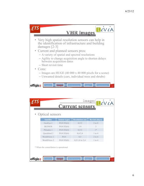
• Very high spatial resolution sensors can help in<br />
the identification of infrastructure and building<br />
damages [2-3]<br />
• Current and planned sensors pros:<br />
– A variety of spatial and spectral resolutions<br />
– Agility to change acquisition angle to shorten delays<br />
between acquisition dates<br />
– Short revisit time<br />
• Cons:<br />
– Images are HUGE (40 000 x 40 000 pixels for a scene)<br />
– Unwanted details (cars, individual trees and shrubs)<br />
11<br />
• Optical sensors<br />
Satellite Sensor types Resolution (m) Revisit (days)<br />
GeoEye-1 PAN/XS(4) 0,5/2 2 to 8<br />
IKONOS PAN/XS(4) 1/4 3<br />
Pléiades-1 PAN/XS(4) 0,5/2 1*<br />
Quickbird 2 PAN/XS(4) 0,6/2,4 1 to 4<br />
WorldView-1 PAN 0,5 2 to 6<br />
WorldView-2 PAN/XS(8) 0,5/1,8 to 2,4 1 to 4<br />
* When the constellation is operational<br />
12<br />
6


