Yarramundi Reserve Cultural Heritage Report - Hawkesbury City ...
Yarramundi Reserve Cultural Heritage Report - Hawkesbury City ...
Yarramundi Reserve Cultural Heritage Report - Hawkesbury City ...

Create successful ePaper yourself
Turn your PDF publications into a flip-book with our unique Google optimized e-Paper software.
YARRAMUNDI RESERVE.<br />
ARCHAEOLOGICAL & CULTURAL<br />
HERITAGE ASSESSMENT.<br />
FOR HAWKESBURY CITY<br />
COUNCIL.<br />
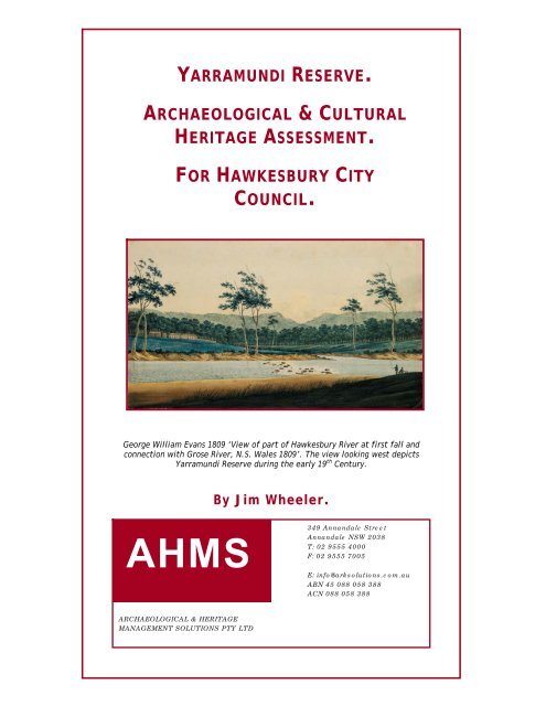
George William Evans 1809 ‘View of part of <strong>Hawkesbury</strong> River at first fall and<br />
connection with Grose River, N.S. Wales 1809’. The view looking west depicts<br />
<strong>Yarramundi</strong> <strong>Reserve</strong> during the early 19 th Century.<br />
By Jim Wheeler.<br />
AHMS<br />
349 Annandale Street<br />
Annandale NSW 2038<br />
T: 02 9555 4000<br />
F: 02 9555 7005<br />
E: info@arksolutions.com.au<br />
ABN 45 088 058 388<br />
ACN 088 058 388<br />
ARCHAEOLOGICAL & HERITAGE<br />
MANAGEMENT SOLUTIONS PTY LTD
YARRAMUNDI RESERVE – ARCHAEOLOGICAL & CULTURAL HERITAGE ASSESSMENT<br />
CONTENTS<br />
Contents................................................................................................... 1<br />
Abbreviations ............................................................................................ 6<br />
1 Introduction ........................................................................................ 8<br />
1.1 Preamble ...................................................................................... 8<br />
1.2 Site identification ........................................................................... 8<br />
1.3 Reason for the current study ............................................................10<br />
1.4 Statutory controls ..........................................................................10<br />
1.4.1 Statutory protection .................................................................10<br />
1.4.2 National Parks & Wildlife Act 1974 ...............................................10<br />
1.4.3 The <strong>Heritage</strong> Act 1977 (amended 1998) ........................................12<br />
1.4.4 Environmental Planning and Assessment Act 1979 ...........................13<br />
1.4.5 Aboriginal and Torres Strait Islander <strong>Heritage</strong> Protection Act 1984<br />
(Commonwealth) .................................................................................14<br />
1.4.6 Environmental Protection & Biodiversity Conservation Act 1999<br />
(Commonwealth) .................................................................................14<br />
1.5 Project aims and objectives .............................................................15<br />
1.5.1 Research ...............................................................................16<br />
1.5.2 Community Consultation............................................................16<br />
1.5.3 Field survey ...........................................................................17<br />
1.5.4 Significance Assessment ............................................................17<br />
1.5.5 Management Opportunities with the local Aboriginal Community .........17<br />
1.5.6 <strong>Report</strong>ing...............................................................................17<br />
1.6 <strong>Report</strong> Outline ..............................................................................18<br />
1.7 Authorship ...................................................................................19<br />
1.8 Acknowledgements ........................................................................19<br />
2 Environmental context..........................................................................20<br />
2.1 Background ..................................................................................20<br />
2.2 Landscape Characteristics................................................................20<br />
AHMS<br />
1<br />
ARCHAEOLOGICAL & HERITAGE<br />
MANAGEMENT SOLUTIONS PTY LTD November 2007
YARRAMUNDI RESERVE – ARCHAEOLOGICAL & CULTURAL HERITAGE ASSESSMENT<br />
2.3 Soils and Geology...........................................................................20<br />
2.4 Vegetation ...................................................................................21<br />
2.5 Landscape Modification ...................................................................22<br />
3 Aboriginal & European History ................................................................26<br />
3.1 Preamble .....................................................................................26<br />
3.2 The Traditional Owners ...................................................................26<br />
3.2.1 The Darug Language .................................................................26<br />
3.2.2 Clans ....................................................................................27<br />
3.2.3 Tribes ...................................................................................27<br />
3.3 Lifestyle of the Traditional Owners ....................................................28<br />
3.3.1 The <strong>Hawkesbury</strong> – Nepean .........................................................29<br />
3.3.2 Resources of the Land...............................................................32<br />
3.3.3 Use of Trees ...........................................................................33<br />
3.3.4 Woodland & Grassland...............................................................33<br />
3.3.5 Swamps and Lagoons ................................................................36<br />
3.3.6 Plant Management ...................................................................37<br />
3.4 Exploration and First Contact ...........................................................38<br />
3.5 Early Settlement & Frontier Relations .................................................42<br />
3.6 Aboriginal Life on the <strong>Hawkesbury</strong>-Nepean ..........................................44<br />
3.6.1 Intensified Settlement ..............................................................44<br />
3.6.2 Further Conflict & Institutionalisation...........................................47<br />
3.6.3 Assimilation & Population Decline ................................................49<br />
3.7 Site Specific History .......................................................................50<br />
3.7.1 Methodology...........................................................................50<br />
3.7.2 Early Settlement......................................................................51<br />
3.7.3 Notification of the <strong>Reserve</strong>.........................................................54<br />
3.7.4 Sand & Gravel Extraction (1924 – 1990’s).......................................55<br />
3.7.5 <strong>Yarramundi</strong> <strong>Reserve</strong> .................................................................61<br />
4 Archaeological Context .........................................................................63<br />
4.1 Regional Aboriginal Archaeological Context ..........................................63<br />
AHMS<br />
2<br />
ARCHAEOLOGICAL & HERITAGE<br />
MANAGEMENT SOLUTIONS PTY LTD November 2007
YARRAMUNDI RESERVE – ARCHAEOLOGICAL & CULTURAL HERITAGE ASSESSMENT<br />
4.1.1 General Background .................................................................63<br />
4.1.2 Early Occupation .....................................................................64<br />
4.1.3 Intensification during the Holocene Period.....................................65<br />
4.1.4 Regional Site Patterns ...............................................................66<br />
4.1.5 Stone Artefacts .......................................................................69<br />
4.2 AHIMS search results.......................................................................70<br />
4.3 Local Archaeological Context............................................................72<br />
4.3.1 Cranebrook Terrace 1974 - 2000 .................................................72<br />
4.3.2 Jamisons Creek 1977 - 1984.......................................................73<br />
4.3.3 Lapstone Creek Salvage - 1977....................................................74<br />
4.3.4 Shaws Creek KII – 1979 - 1980.....................................................74<br />
4.3.5 Regentville RS1 – 1994-1999.......................................................75<br />
4.3.6 Rouse Hill Infrastructure Development..........................................75<br />
4.3.7 Blighton, Pitt Town – 2005 .........................................................77<br />
4.3.8 Springwood Road, <strong>Yarramundi</strong> – 2002 ...........................................78<br />
4.3.9 Agnes Banks Survey – 1984.........................................................79<br />
4.3.10 Boral Extraction, <strong>Yarramundi</strong> – 1983.............................................79<br />
4.4 Predictive Modeling........................................................................80<br />
4.4.1 Site Types ..............................................................................80<br />
4.4.2 Aboriginal Site Predictions .........................................................81<br />
4.5 Historical Archaeological Predictions ..................................................81<br />
5 Survey ..............................................................................................83<br />
5.1 Survey Details ...............................................................................83<br />
5.2 Survey Methodology .......................................................................83<br />
5.3 Survey Coverage............................................................................83<br />
5.4 Survey Results ..............................................................................84<br />
5.4.1 General Observations................................................................84<br />
5.4.2 Individual Items.......................................................................87<br />
5.4.2.1 Item 1 & 2 – Aboriginal sites .................................................87<br />
5.4.2.2 Item 3 & 4 – 1937 railway and bins .........................................88<br />
AHMS<br />
3<br />
ARCHAEOLOGICAL & HERITAGE<br />
MANAGEMENT SOLUTIONS PTY LTD November 2007
YARRAMUNDI RESERVE – ARCHAEOLOGICAL & CULTURAL HERITAGE ASSESSMENT<br />
5.4.2.3 Item 5 – 1943 building.........................................................89<br />
5.4.2.4 Item 6 – Ashton’s Falls.........................................................89<br />
5.4.2.5 Item 7 – Mill Race...............................................................89<br />
5.4.2.6 Item 8 – Archaeological Potential ...........................................89<br />
5.5 Conclusions ..................................................................................90<br />
6 Aboriginal Community Consultation..........................................................92<br />
6.1 Development of Consultation............................................................92<br />
6.2 Outcomes of Consultation ................................................................94<br />
7 Significance Assessment ........................................................................95<br />
7.1 Aboriginal <strong>Heritage</strong> Significance Assessment.........................................95<br />
7.1.1 Basis for significance assessment .................................................95<br />
7.1.2 Aboriginal <strong>Cultural</strong> Significance ...................................................95<br />
7.1.3 Public Significance ...................................................................96<br />
7.1.4 Scientific Significance ...............................................................96<br />
7.2 Historical <strong>Heritage</strong> Significance .........................................................97<br />
7.2.1 Principles and evaluation criteria ................................................97<br />
7.2.2 Evaluation..............................................................................99<br />
8 Impact Assessment ............................................................................. 100<br />
8.1 Proposed Development ................................................................. 100<br />
8.2 Impact Assessment ....................................................................... 100<br />
9 Interpretation................................................................................... 102<br />
9.1 Preamble ................................................................................... 102<br />
9.2 Themes ..................................................................................... 102<br />
9.3 Interpretation Options .................................................................. 103<br />
9.3.1 Aboriginal life on the River ...................................................... 103<br />
9.3.2 Early Exploration of the River ................................................... 105<br />
9.3.3 River as a Resource ................................................................ 107<br />
10 Recommendations........................................................................... 109<br />
10.1 Basis for Recommendations ......................................................... 109<br />
AHMS<br />
4<br />
ARCHAEOLOGICAL & HERITAGE<br />
MANAGEMENT SOLUTIONS PTY LTD November 2007
YARRAMUNDI RESERVE – ARCHAEOLOGICAL & CULTURAL HERITAGE ASSESSMENT<br />
10.2 Aboriginal Consultation .............................................................. 109<br />
10.3 Archaeological management ........................................................ 110<br />
References............................................................................................. 112<br />
Appendix 1 –........................................................................................... 117<br />
Aboriginal Community Correspondence ......................................................... 117<br />
AHMS<br />
5<br />
ARCHAEOLOGICAL & HERITAGE<br />
MANAGEMENT SOLUTIONS PTY LTD November 2007
YARRAMUNDI RESERVE – ARCHAEOLOGICAL & CULTURAL HERITAGE ASSESSMENT<br />
ABBREVIATIONS<br />
AHC<br />
AHIA<br />
AHIMS<br />
CHL<br />
DECC<br />
DEH<br />
DoP<br />
EA<br />
EIA<br />
EIS<br />
EP&A<br />
EPBC<br />
GSV<br />
Australian <strong>Heritage</strong> Council<br />
Aboriginal <strong>Heritage</strong> Impact Assessment<br />
Aboriginal <strong>Heritage</strong> Information Management System<br />
Commonwealth <strong>Heritage</strong> List<br />
Dept of Environment & Climate Change<br />
Department of Environment and <strong>Heritage</strong><br />
Department of Planning<br />
Environmental Assessment<br />
Environment Impact Assessment<br />
Environmental Impact Statement<br />
Environmental Planning and Assessment<br />
Environment Protection and Biodiversity Conservation<br />
Ground surface visibility<br />
ICOMOS International Council on Monuments and Sites<br />
LALC<br />
LEP<br />
LGA<br />
MGA<br />
NHL<br />
NNTT<br />
NPWS<br />
REF<br />
REP<br />
Local Aboriginal Land Council<br />
Local Environmental Plan<br />
Local Government Area<br />
Map Grid of Australia – unless otherwise specified all coordinates are in MGA<br />
National <strong>Heritage</strong> List<br />
National Native Title Tribunal<br />
National Parks and Wildlife Service (now part of DECC)<br />
Review of Environmental Factors<br />
Regional Environment Plan<br />
AHMS<br />
6<br />
ARCHAEOLOGICAL & HERITAGE<br />
MANAGEMENT SOLUTIONS PTY LTD November 2007
YARRAMUNDI RESERVE – ARCHAEOLOGICAL & CULTURAL HERITAGE ASSESSMENT<br />
RNE<br />
SHI<br />
SHR<br />
SOHI<br />
Register of the National Estate<br />
State <strong>Heritage</strong> Inventory<br />
State <strong>Heritage</strong> Register<br />
Statement of <strong>Heritage</strong> Impact<br />
S.90 Section 90 of the National Parks & Wildlife Act 1974<br />
S.87 Section 87 of the National Parks & Wildlife Act 1974<br />
S.140 Section 140 of the NSW <strong>Heritage</strong> Act 1977<br />
S.60 Section 60 of the NSW <strong>Heritage</strong> Act 1977<br />
AHMS<br />
7<br />
ARCHAEOLOGICAL & HERITAGE<br />
MANAGEMENT SOLUTIONS PTY LTD November 2007
YARRAMUNDI RESERVE – ARCHAEOLOGICAL & CULTURAL HERITAGE ASSESSMENT<br />
1 INTRODUCTION<br />
1.1 Preamble<br />
<strong>Hawkesbury</strong> <strong>City</strong> Council engaged Archaeological and <strong>Heritage</strong> Management<br />
Solutions (AHMS) Pty Ltd to undertake an archaeological and cultural heritage<br />
assessment of <strong>Yarramundi</strong> <strong>Reserve</strong>, <strong>Yarramundi</strong>, NSW. The assessment was<br />
commissioned to document and assess the cultural values of the <strong>Reserve</strong> and<br />
provide management strategies in advance of proposed landscaping and visitor<br />
upgrade works proposed by the draft Plan of Management for the <strong>Reserve</strong> . 1<br />
1.2 Site identification<br />
The subject land is located at the confluence of the Grose and Nepean Rivers,<br />
which form the start of the <strong>Hawkesbury</strong> River (Figure 1).<br />
The study area lies to the west of Agnes Banks, south of Grosewold and north of the<br />
small township of <strong>Yarramundi</strong>. The <strong>Reserve</strong> straddles both sides of the Nepean<br />
River, although most of the land is located on the western side of the river.<br />
<strong>Yarramundi</strong> <strong>Reserve</strong> was transferred to the Crown in 2002 with <strong>Hawkesbury</strong> <strong>City</strong><br />
Council appointed as the <strong>Reserve</strong> Trust Manager. The <strong>Reserve</strong> covers an area of 78<br />
hectares and is comprised of a lineal parcel of land and water (including the river<br />
bed). It is located wholly within the riparian corridor and comprises a diverse<br />
landscape of natural river and flood channels, former quarried lagoons and backwaters,<br />
steep river banks and gently sloping foreshores.<br />
The reserve comprises Crown land parcels Lot 1 DP 1040789 (formerly Lot 190 DP<br />
803295), Lot 3 DP 393015 (formerly Lot 191 DP 803295), Lots 188 – 189 inclusive DP<br />
803295, Lot 90 DP 786549, Lots 57 and 293 DP 751660, and Part Lot 28 DP 752021<br />
within the Parishes of Ham Common, County of Cumberland and Parishes of<br />
Castlereagh and Nepean, County of Cook.<br />
1 Landarc 2004<br />
AHMS<br />
8<br />
ARCHAEOLOGICAL & HERITAGE<br />
MANAGEMENT SOLUTIONS PTY LTD November 2007
YARRAMUNDI RESERVE – ARCHAEOLOGICAL & CULTURAL HERITAGE ASSESSMENT<br />
<strong>Yarramundi</strong><br />
<strong>Reserve</strong><br />
Figure 1.<br />
Location Plan (<strong>Yarramundi</strong> <strong>Reserve</strong> is shaded dark blue).<br />
AHMS<br />
9<br />
ARCHAEOLOGICAL & HERITAGE<br />
MANAGEMENT SOLUTIONS PTY LTD November 2007
YARRAMUNDI RESERVE – ARCHAEOLOGICAL & CULTURAL HERITAGE ASSESSMENT<br />
1.3 Reason for the current study<br />
The purpose of the assessment is to develop procedures for management of<br />
Aboriginal and non-Indigenous archaeological sites and cultural heritage values<br />
within the <strong>Reserve</strong>. The assessment will augment Council’s Plan of Management<br />
(POM) for the <strong>Reserve</strong> as a companion document specifically dealing with cultural<br />
heritage management.<br />
The principal objectives are to identify known and potential threats to cultural<br />
heritage sites, objects and values within the <strong>Reserve</strong>, including landscaping and<br />
visitor facility upgrade and other works proposed by the POM (such as<br />
environmental re-generation, pedestrian trail construction and maintenance etc)<br />
and ad hoc impacts that may be associated with public use and access to the<br />
<strong>Reserve</strong>.<br />
The assessment also aims to identify opportunities for future public interpretation<br />
and Aboriginal community involvement in managing the <strong>Reserve</strong>.<br />
1.4 Statutory controls<br />
1.4.1 Statutory protection<br />
The National Parks & Wildlife Act (1974), the NSW <strong>Heritage</strong> Act (1977) and the<br />
Environmental Planning and Assessment Act (1979) provide the statutory tools for<br />
archaeological and cultural heritage management in New South Wales. The<br />
Aboriginal and Torres Strait Islander <strong>Heritage</strong> Protection Act 1984 and the<br />
Environmental Protection and Biodiversity Conservation (EPBC) Act 1999 also<br />
provide heritage protection at a Federal level. The implications of these statutes<br />
are outlined overleaf.<br />
1.4.2 National Parks & Wildlife Act 1974<br />
The provisions of the NP & W Act (1974) provide blanket protection for Aboriginal<br />
objects (material evidence of indigenous occupation) and Aboriginal places (areas<br />
of cultural significance to the Aboriginal community).<br />
AHMS 10<br />
ARCHAEOLOGICAL & HERITAGE<br />
MANAGEMENT SOLUTIONS PTY LTD September 2007
YARRAMUNDI RESERVE – ARCHAEOLOGICAL & CULTURAL HERITAGE ASSESSMENT<br />
The following sections are particularly pertinent:<br />
• Section 91 states that anyone who discovers an Aboriginal object is obliged<br />
to report the discovery to the DECC.<br />
• Section 90 states that it is an offence to destroy, deface, damage or<br />
desecrate, or cause or permit the destruction, defacement, damage or<br />
desecration of, an Aboriginal object or Aboriginal place.<br />
• Section 86 and 87 state that it is an offence to collect or disturb objects or<br />
excavate, or in any way disturb land for the purpose of discovering objects<br />
without a permit authorised by the Director-General DECC.<br />
• Section 84 makes provision for protection of 'Aboriginal Places' or locations<br />
of special significance to Aboriginal culture.<br />
In practical terms, the provisions of the Act require an archaeological assessment<br />
of any land where there is potential that Aboriginal sites or objects may be<br />
impacted by development. Aboriginal archaeological assessments are guided by the<br />
NPWS Guidelines for Archaeological Survey and <strong>Report</strong>ing (1997). These guidelines<br />
require consultation with Aboriginal communities and relevant representative<br />
bodies such as Local Aboriginal Land Councils (LALCs) and Traditional Owner<br />
groups. This includes Aboriginal community participation in all archaeological<br />
survey and excavation work and consideration of the Aboriginal cultural<br />
significance of sites and places.<br />
In accordance with Section 90 of the National Parks & Wildlife Act 1974, all<br />
Aboriginal objects are protected and cannot be destroyed or disturbed without<br />
Consent under Section 90 of the National Parks & Wildlife Act 1974 from DEC.<br />
Protection is provided irrespective of both the level of significance of the objects<br />
and issues of land tenure.<br />
In 2004 DEC released Interim Community Consultation Requirements for Applicants<br />
that require a series of formal Aboriginal community consultation and notification<br />
procedures for sites that require applications under Section 87 or Section 90 of the<br />
National Parks & Wildlife Act 1974.<br />
AHMS 11<br />
ARCHAEOLOGICAL & HERITAGE<br />
MANAGEMENT SOLUTIONS PTY LTD September 2007
YARRAMUNDI RESERVE – ARCHAEOLOGICAL & CULTURAL HERITAGE ASSESSMENT<br />
In summary, the following procedures are required:<br />
1. Notification and Registration of Interests: The consultant must actively seek to<br />
identify stakeholder groups by:<br />
(a) providing written notification to Local Aboriginal Land Council(s), Registrar<br />
of Aboriginal Owners, Native Title Services, Local Council(s), and DEC; and<br />
(b)<br />
placing an advertisement in the local print media.<br />
The closing date for registration of interest must allow at least 10 working days for<br />
groups to respond.<br />
2. Preparation of the Assessment Methodology: The consultant must present and/or<br />
provide Registered Stakeholders with a proposed methodology for the assessment /<br />
testing methodology. The stakeholders must be allowed at least 21 days to review<br />
and provide feedback to the consultant.<br />
3. Drafting, Review and Finalisation of the Assessment <strong>Report</strong>: Following<br />
completion of the survey a draft Aboriginal <strong>Heritage</strong> Impact Assessment (AHIA)<br />
report on the cultural and archaeological significance of the study area should be<br />
made available to all Registered Stakeholders and the Local Aboriginal Land Council<br />
for comment. After considering comments received, the consultant must then<br />
finalise the report and submit to DEC for consideration with their application.<br />
1.4.3 The <strong>Heritage</strong> Act 1977 (amended 1998)<br />
The <strong>Heritage</strong> Act 1977 provides automatic statutory protection for ‘relics’. The Act<br />
defines relics as:<br />
‘any deposit, object or material evidence relating to the settlement<br />
of the area that comprises NSW, not being an Aboriginal settlement,<br />
and which is 50 or more years old.’<br />
Sections 139 to 145 of the Act prevent the excavation or disturbance of land for the<br />
purpose of discovering, exposing or moving a relic, except by a qualified<br />
archaeologist to whom an excavation permit has been issued by the <strong>Heritage</strong><br />
AHMS 12<br />
ARCHAEOLOGICAL & HERITAGE<br />
MANAGEMENT SOLUTIONS PTY LTD September 2007
YARRAMUNDI RESERVE – ARCHAEOLOGICAL & CULTURAL HERITAGE ASSESSMENT<br />
Council of NSW. The protection is provided irrespective of either the level of<br />
significance of the objects or issues of land tenure.<br />
In practical terms, the provisions of the Act require an archaeological assessment<br />
of any land where there is potential for historical archaeological relics to be<br />
disturbed by development. The required format of historical archaeological<br />
assessments is set out in the Archaeological Assessment Guidelines (1996).<br />
If the presence of significant relics is indicated by a site assessment, the NSW<br />
<strong>Heritage</strong> Office (delegated authority of the <strong>Heritage</strong> Council) generally requires<br />
archaeological test excavation of the site before development in order to:<br />
• physically determine the nature, extent and significance of any such relics;<br />
and<br />
• determine an appropriate strategy for their management during future<br />
development.<br />
1.4.4 Environmental Planning and Assessment Act 1979<br />
The EP & A Act 1979 requires that environmental and heritage impacts are<br />
considered by consent authorities prior to granting development approvals. Under<br />
Part IV of the Act, specific approval from state agencies may be required in certain<br />
circumstances. This mechanism is known as an ‘integrated development<br />
application’ or IDA.<br />
The DECC and NSW <strong>Heritage</strong> Office are approval bodies in the IDA process when a<br />
development will impact respectively on an Aboriginal object / place or an<br />
historical relic and thereby require Consent from DECC or NSW <strong>Heritage</strong> Office. In<br />
such circumstances, consent must be granted by DECC and/or NSW <strong>Heritage</strong> Office<br />
prior to a development being approved.<br />
The provisions of the EP & A Act 1979 are largely irrelevant to the current project<br />
as a development approval will not be required for the proposed works – Council is<br />
the proponent.<br />
AHMS 13<br />
ARCHAEOLOGICAL & HERITAGE<br />
MANAGEMENT SOLUTIONS PTY LTD September 2007
YARRAMUNDI RESERVE – ARCHAEOLOGICAL & CULTURAL HERITAGE ASSESSMENT<br />
1.4.5 Aboriginal and Torres Strait Islander <strong>Heritage</strong><br />
Protection Act 1984 (Commonwealth)<br />
The Aboriginal and Torres Strait Islander <strong>Heritage</strong> Protection Act 1984 was enacted<br />
at a Federal level to preserve and protect areas (particularly sacred sites) and<br />
objects of particular significance to Aboriginal Australians from damage or<br />
desecration. Steps necessary for the protection of a threatened place are outlined<br />
in a gazetted Ministerial Declaration (Sections 9 and 10). This can include the<br />
prevention of development.<br />
As well as providing protection to areas, it can also protect objects by Declaration,<br />
in particular Aboriginal skeletal remains (Section 12). Although this is a Federal<br />
Act, it can be invoked if a State is unwilling or unable to provide protection for<br />
such sites or objects.<br />
There are no Aboriginal sites or places within the study area currently subject to a<br />
Declaration.<br />
1.4.6 Environmental Protection & Biodiversity<br />
Conservation Act 1999 (Commonwealth)<br />
The EPBC Act provides protection for natural and cultural heritage places at a<br />
Federal level. The Act established three heritage registers: World heritage,<br />
Commonwealth heritage and National heritage. World heritage items are those<br />
listed for outstanding international heritage values. National heritage items are<br />
assessed as having natural or cultural significance at a national level. The World<br />
and National lists may include items on private or State crown land. The<br />
Commonwealth list only includes items on land owned by the Commonwealth.<br />
Items on the registers described above are protected under the terms of the EPBC<br />
Act. The Act requires approval before any action takes place which has, will have,<br />
or is likely to have, a significant impact on the heritage values of a listed place.<br />
Proposals for actions which could affect such values are rigorously assessed. The<br />
EPBC Act is administered by the Australian <strong>Heritage</strong> Council.<br />
There are no items within the study area currently listed as items of National or<br />
World heritage.<br />
AHMS 14<br />
ARCHAEOLOGICAL & HERITAGE<br />
MANAGEMENT SOLUTIONS PTY LTD September 2007
YARRAMUNDI RESERVE – ARCHAEOLOGICAL & CULTURAL HERITAGE ASSESSMENT<br />
1.5 Project aims and objectives<br />
Specific aims of the study were as follows:<br />
• Identify, record and assess Aboriginal and non-Aboriginal heritage sites and<br />
areas of potential archaeological deposit (PAD) within <strong>Yarramundi</strong> <strong>Reserve</strong> and<br />
determine their significance in consultation with relevant Aboriginal<br />
community organisations;<br />
• Establish a register of Aboriginal Stakeholder Groups by following the first step<br />
of the Department of Environment and Climate Change (DECC) Interim<br />
Community Consultation Requirements (2004);<br />
• Assess the impact of current and future recreational uses of the <strong>Reserve</strong> on<br />
identified heritage items and recognize potential opportunities and constraints<br />
for the improvement of facilities;<br />
• Apply general principles & policies of heritage management to develop clear,<br />
concise management strategies to conserve the <strong>Reserve</strong>’s heritage sites and<br />
mitigate current and future impacts on their heritage values; and<br />
• Investigate opportunities for local Aboriginal involvement in a management<br />
role, including cross-cultural training, visitor management and interpretation<br />
of the Aboriginal heritage values of the <strong>Reserve</strong>.<br />
The assessment was undertaken in accordance with the:<br />
• Legislative requirements of the NSW National Parks and Wildlife Act (1974),<br />
NSW <strong>Heritage</strong> Act (1977) and relevant Federal legislation cited above;<br />
• Procedures for Aboriginal heritage assessments and management outlined in<br />
the Aboriginal <strong>Cultural</strong> <strong>Heritage</strong> Standards and Guidelines Kit (National Parks<br />
and Wildlife Service, 1997);<br />
• Procedures for historical archaeological assessments outlined in the NSW<br />
<strong>Heritage</strong> Office Manual 1996; and<br />
AHMS 15<br />
ARCHAEOLOGICAL & HERITAGE<br />
MANAGEMENT SOLUTIONS PTY LTD September 2007
YARRAMUNDI RESERVE – ARCHAEOLOGICAL & CULTURAL HERITAGE ASSESSMENT<br />
• Australia ICOMOS 'Burra' Charter for the conservation of culturally significant<br />
places and associated guidelines regarding significance assessment,<br />
conservation policy and processes.<br />
The assessment required completion of the following tasks:<br />
1.5.1 Research<br />
• Review of previous archaeological investigations and studies carried out in the<br />
<strong>Yarramundi</strong> area;<br />
• A search of the DECC Aboriginal <strong>Heritage</strong> Information Management System<br />
(AHIMS) in order to determine the type and distribution of Aboriginal sites that<br />
have been recorded in the vicinity of the study area;<br />
• Preparation of a predictive model of the “archaeological potential” of the<br />
study area, including prediction of the potential for unrecorded Aboriginal<br />
sites to occur within the study area; and<br />
• Review of existing heritage studies and historic source material (including<br />
maps, plans and texts showing and/or discussing past historical use of the site)<br />
to prepare a brief history of <strong>Yarramundi</strong> <strong>Reserve</strong> and to identify any evidence<br />
of past historical occupation and any other heritage values pertaining to the<br />
land.<br />
1.5.2 Community Consultation<br />
• Undertake the first stage of the Department of Environment and Climate<br />
Change (DECC) Interim Community Consultation Requirements (2004) to<br />
establish a register of Aboriginal Stakeholder Groups interested in future<br />
management of the <strong>Reserve</strong>. Groups who register their interest will then be<br />
consulted with about the project and will be asked to comment on the draft<br />
assessment report.<br />
• Consult with the registered Aboriginal stakeholders to determine the cultural<br />
significance of the area; and<br />
• Liaise with the <strong>Hawkesbury</strong> Historical Society to obtain any information about<br />
historic sites or values within the <strong>Reserve</strong>.<br />
AHMS 16<br />
ARCHAEOLOGICAL & HERITAGE<br />
MANAGEMENT SOLUTIONS PTY LTD September 2007
YARRAMUNDI RESERVE – ARCHAEOLOGICAL & CULTURAL HERITAGE ASSESSMENT<br />
1.5.3 Field survey<br />
• Record Aboriginal sites or Historical relics within the <strong>Reserve</strong>;<br />
• Identify any areas that have archaeological potential based on the results of<br />
field survey, predictive modelling and previous investigations in the area;<br />
• Assess the potential for buried sub-surface Aboriginal and/or historical<br />
archaeological deposits within the area; and<br />
• Determine the degree to which previous development and landscape<br />
modification has disturbed original soils, and assess its implications for<br />
preservation of archaeological deposits.<br />
1.5.4 Significance Assessment<br />
• Assess the cultural significance of any historical archaeological relics or<br />
deposits with potential to contain relics; and<br />
• Assess the scientific, public and Aboriginal (cultural) heritage significance of<br />
any Aboriginal sites, objects or places.<br />
1.5.5 Management Opportunities with the local<br />
Aboriginal Community<br />
• Undertake preliminary consultation with representatives of the Deerubbin<br />
Local Aboriginal Land Council, Darug Tribal Aboriginal Corporation and Darug<br />
Custodian Aboriginal Corporation and any other stakeholders identified by the<br />
notification procedures; and<br />
• Discuss opportunities for local Aboriginal involvement with the management of<br />
<strong>Yarramundi</strong> <strong>Reserve</strong>. Each of the registered Stakeholders were asked to<br />
provide their written advice regarding cross-cultural training, visitor<br />
management and interpretation of Aboriginal heritage values of the <strong>Reserve</strong>.<br />
1.5.6 <strong>Report</strong>ing<br />
• Preparation of an assessment report for <strong>Hawkesbury</strong> <strong>City</strong> Council documenting<br />
the results of the study;<br />
AHMS 17<br />
ARCHAEOLOGICAL & HERITAGE<br />
MANAGEMENT SOLUTIONS PTY LTD September 2007
YARRAMUNDI RESERVE – ARCHAEOLOGICAL & CULTURAL HERITAGE ASSESSMENT<br />
• Identify heritage constraints and opportunities for any Aboriginal or Historical<br />
heritage items or values within the study area;<br />
• Recommend appropriate management of Aboriginal objects and/or historical<br />
archaeological relics, and mitigation of potential heritage impacts posed by<br />
proposed works, in accordance with the requirements of the National Parks &<br />
Wildlife Act 1974 and <strong>Heritage</strong> Act 1977; and<br />
• Prepare relevant DECC site cards and <strong>Heritage</strong> Inventory Forms for any<br />
Aboriginal or historical sites identified in the <strong>Reserve</strong>.<br />
1.6 <strong>Report</strong> Outline<br />
The remainder of the report is set out as follows:<br />
• Description of the environmental context including the implications of<br />
landscape modifications caused by flooding and sand/gravel extraction<br />
(Section 2.0).<br />
• A chronological site history that includes a review of the Aboriginal ethnohistory<br />
for the region using early documentary records, a contact history and a<br />
review of historical occupation and use of the site using documentary records,<br />
maps, plans, illustrations and photographs (Section 3.0).<br />
• Review of the local and regional archaeological context, including predictions<br />
regarding types of archaeological evidence that may be present in the<br />
development area (Section 4.0).<br />
• Description of the archaeological field survey results (Section 5.0).<br />
• Results of Aboriginal community consultation (Section 6.0).<br />
• Assessment of the heritage significance of the study area (Section 7.0).<br />
• Impact assessment (Section 8.0)<br />
• A discussion of interpretation options, including themes and recommendations<br />
for implementation (Section 9.0)<br />
• Management recommendations (Section 10.0).<br />
AHMS 18<br />
ARCHAEOLOGICAL & HERITAGE<br />
MANAGEMENT SOLUTIONS PTY LTD September 2007
YARRAMUNDI RESERVE – ARCHAEOLOGICAL & CULTURAL HERITAGE ASSESSMENT<br />
1.7 Authorship<br />
This report was written by archaeologist Jim Wheeler. Archaeologist Adam<br />
Paterson assisted with historical research. Archaeologists Lisa Campbell and Felicity<br />
Barry assisted with plans and graphics.<br />
1.8 Acknowledgements<br />
The authors acknowledge the assistance and valuable input provided by Steve<br />
Randall of the Deerubbin Local Aboriginal Land Council, Leanne Watson of the<br />
Darug Custodian Aboriginal Corporation, Gordon Workman of the Darug Tribal<br />
Aboriginal Corporation and Celestine Everingham representing Gordon Morton of<br />
Darug Aboriginal <strong>Cultural</strong> <strong>Heritage</strong> Assessments. We would also like to acknowledge<br />
the valuable assistance provided by John Bosque and Michelle Engelhard of<br />
<strong>Hawkesbury</strong> <strong>City</strong> Council.<br />
AHMS 19<br />
ARCHAEOLOGICAL & HERITAGE<br />
MANAGEMENT SOLUTIONS PTY LTD September 2007
YARRAMUNDI RESERVE – ARCHAEOLOGICAL & CULTURAL HERITAGE ASSESSMENT<br />
2 ENVIRONMENTAL CONTEXT<br />
2.1 Background<br />
Archaeological assessment reports include information about the environmental<br />
context of study areas because of the important role environmental characteristics<br />
played in influencing the types of archaeological sites in any given area. Physical<br />
environments influenced both the type and availability of natural resources and the<br />
types of cultural activities that were carried out in the past. As a result, this also<br />
influenced the types of archaeological sites that may be found.<br />
A determination of the former environmental context is essential to develop<br />
accurate models of cultural activity, site distribution patterns and the<br />
archaeological potential of any given area. The environmental setting of the study<br />
area is discussed below.<br />
2.2 Landscape Characteristics<br />
The <strong>Reserve</strong> lies within the active floodplain of the <strong>Hawkesbury</strong> – Nepean River,<br />
which is characterised by broad, relatively flat floodplains, meander scrolls, levees<br />
and wetlands. It is a highly dynamic environment that is constantly changing<br />
through the processes of alluvial deposition (gradual accretion and flood<br />
deposition) and channel scouring. The river channels, embankments, lagoons and<br />
islands are all affected by these on-going and at times dramatic changes. Historical<br />
evidence indicates large flood events have obliterated past river channels and<br />
created entirely new channel patterns and landscapes during the last 200 years.<br />
2.3 Soils and Geology<br />
The study area lies on the Freeman’s Reach alluvial soil landscape, which comprises<br />
banks, beds and levees of the <strong>Hawkesbury</strong>-Nepean River. The parent material is<br />
alluvium deposited by the river system.<br />
The soils are typically deep layered unconsolidated sediments (ie. sands and loams)<br />
deposited during floods. The river system has a sinuous, meandering character<br />
AHMS 20<br />
ARCHAEOLOGICAL & HERITAGE<br />
MANAGEMENT SOLUTIONS PTY LTD September 2007
YARRAMUNDI RESERVE – ARCHAEOLOGICAL & CULTURAL HERITAGE ASSESSMENT<br />
flowing over and through its own deposited material of gravel, cobble, sand and<br />
soil.<br />
Sediments within the southern portion of the reserve (upstream of <strong>Yarramundi</strong><br />
Bridge) are typically fine-grained dark-brown and red-brown alluvial loams. This<br />
contrasts with the northern portion of the reserve (downstream of <strong>Yarramundi</strong><br />
Bridge), which is influenced by the Grose River. Sediments of the Grose River are<br />
dominated by coarse-grained alluvial sand, gravel and cobbles. These materials<br />
have been deposited along the lower reach of the Grose River (adjacent to Navua<br />
<strong>Reserve</strong>), the western bars and beaches and throughout the northern flood<br />
channel.<br />
The gravel and cobble deposits contain a wide variety of workable stone materials<br />
used by Aboriginal people for making stone implements. Numerous studies have<br />
identified the gravel bars of the <strong>Hawkesbury</strong>-Nepean System as important<br />
traditional stone sources, particularly for indurated mudstone / tuff cobbles 2 .<br />
2.4 Vegetation<br />
Original vegetation within the study area was removed by flooding and quarrying.<br />
Current vegetation across the study area comprises a variety of re-growth<br />
communities.<br />
During the first European expedition up the <strong>Hawkesbury</strong> River in 1789, Capt. John<br />
Hunter described the country around Richmond Hill (just north of the study area)<br />
as:<br />
“…perfectly clear of any kind of under-wood; the trees upon it were<br />
all very tall, and stood very wide apart; the soil was also examined,<br />
and found [to be] very good..”<br />
More specific detail about the study area was provided on an 1891 Survey Plan,<br />
which described the study area as a large island of “sand and boulders” that was<br />
covered in pasture grass and timbered with “River Wattle and Oak”.<br />
2 Kohen 1986: 229<br />
AHMS 21<br />
ARCHAEOLOGICAL & HERITAGE<br />
MANAGEMENT SOLUTIONS PTY LTD September 2007
YARRAMUNDI RESERVE – ARCHAEOLOGICAL & CULTURAL HERITAGE ASSESSMENT<br />
2.5 Landscape Modification<br />
The river channels, banks and islands within the study area have been modified<br />
through the effects of erosion, flood scouring, alluvial deposition, cultivation and<br />
quarrying. The effects of flood scouring and quarrying on the study area have been<br />
profound.<br />
Removal of original vegetation during the 19 th century exposed soils to erosion.<br />
During flooding events, soils on river banks were exposed and scoured away without<br />
the protection of tree and grass root systems. Further up river catchments, rain<br />
washed exposed surface soils into rivers causing a large amount of silt deposition<br />
further downstream. The archaeological implications are two-fold. In areas that<br />
have been scoured away by flooding, Aboriginal sites and objects have been<br />
removed. In areas that have been covered with silt deposited during flooding,<br />
original land-surfaces that may contain Aboriginal sites and objects have been<br />
covered.<br />
In addition to the effects of flooding and erosion, the study area was substantially<br />
modified by gravel and sand extraction between 1927 and 1994. Boral Resources<br />
(formerly BMG Resources Ltd) removed large quantities of material from the study<br />
area and so doing formed the artificial lagoons, spoil heaps and islands that created<br />
<strong>Yarramundi</strong> <strong>Reserve</strong> in its current form we see today.<br />
A Comparison of the current River configuration with early descriptions of the River<br />
illustrates the degree of modification the study area has undergone. Capt John<br />
Hunter was a member of the 1789 expedition up the <strong>Hawkesbury</strong> River and<br />
provided the following description of the study area and surrounds 3 :<br />
“In the morning of the 6th, we examined the river, which, as I have<br />
before observed, was narrow and shoally; its bed was composed of<br />
loose round stones and sand….We here found the river to divide into<br />
two narrow branches, from one of which the stream came down with<br />
considerable velocity, and with a fall 4 over a range of stones which<br />
seemed to lye across its entrance: this was the fall which we had<br />
3 Hunter 1793: 6 th July Diary Entry<br />
4 This probably refers to “<strong>Yarramundi</strong> Falls” or “Ashton’s Falls”<br />
AHMS 22<br />
ARCHAEOLOGICAL & HERITAGE<br />
MANAGEMENT SOLUTIONS PTY LTD September 2007
YARRAMUNDI RESERVE – ARCHAEOLOGICAL & CULTURAL HERITAGE ASSESSMENT<br />
heard the night before from our situation on the side of Richmondhill.”<br />
This early description of fast flowing narrow river channels with waterfalls<br />
contrasts with its current form, which could probably be described as broad, slowmoving<br />
and flat-bottomed (ie. devoid of any “falls”).<br />
The development of the study area during the late 19 th century and the 20 th<br />
century is shown in the following figures 2 – 5 and described below. Each figure has<br />
a ‘best-fit’ overlay of the current stream and lagoon configuration (shaded blue)<br />
overlain on the original plan or photo. This illustrates the degree to which the<br />
stream, banks and islands have been modified over the last 120 years.<br />
Mill Race<br />
Ashton’s Falls<br />
Original channel<br />
indicated by dashed<br />
line<br />
Figure 2. 1893 Parish Map showing Ashton’s Falls (possibly the same as ‘<strong>Yarramundi</strong> Falls’), the original river<br />
channel and a mill race. The current river channels (shaded blue) have a dramatically different configuration.<br />
(Source: Parish Map Preservation Project).<br />
AHMS 23<br />
ARCHAEOLOGICAL & HERITAGE<br />
MANAGEMENT SOLUTIONS PTY LTD September 2007
YARRAMUNDI RESERVE – ARCHAEOLOGICAL & CULTURAL HERITAGE ASSESSMENT<br />
Original course of<br />
the Grose River<br />
(now in-filled)<br />
Original western<br />
channel of the<br />
Nepean (now infilled)<br />
Figure 3. 1947 Aerial Photo showing original western channel of the Nepean (now in-filled) and the original course<br />
of the Grose River (now completely altered). (Source: Dept of Lands).<br />
Western channel<br />
of the Nepean<br />
in-filled<br />
Extensive sand and<br />
gravel extraction<br />
(particularly across<br />
southern and central<br />
portions of the study<br />
area)<br />
Figure 4. 1961 Aerial Photo showing extensive sand and gravel extraction underway and the western channel of the<br />
Nepean in-filled. (Source: Dept of Lands).<br />
AHMS 24<br />
ARCHAEOLOGICAL & HERITAGE<br />
MANAGEMENT SOLUTIONS PTY LTD September 2007
YARRAMUNDI RESERVE – ARCHAEOLOGICAL & CULTURAL HERITAGE ASSESSMENT<br />
Sand & gravel<br />
extraction has moved<br />
Areas to the heavily western disturbed and<br />
by northern sand and portions gravel of<br />
extraction the study area) (extraction<br />
Figure 5. 1978 Aerial Photo showing sand and gravel extraction underway on western and northern portions of the<br />
study area. (Source: Dept of Lands). The study area is starting to resemble its current configuration (shaded blue).<br />
AHMS 25<br />
ARCHAEOLOGICAL & HERITAGE<br />
MANAGEMENT SOLUTIONS PTY LTD September 2007
YARRAMUNDI RESERVE – ARCHAEOLOGICAL & CULTURAL HERITAGE ASSESSMENT<br />
3 ABORIGINAL & EUROPEAN HISTORY<br />
3.1 Preamble<br />
This section presents a history of Aboriginal use and occupation of the study area<br />
based on documentary evidence and early ethnographic records. A summary of<br />
historical use and occupation of the study is also included for the purpose of<br />
assessing the historical heritage values of the <strong>Reserve</strong> and to identify any historical<br />
archaeological relics that may survive post-sand mining.<br />
3.2 The Traditional Owners<br />
The first people known to have an association with the study area were people of<br />
the Darug language group.<br />
There is considerable ongoing debate about the nature, territory and range of the<br />
pre-contact Aboriginal language groups of the greater Sydney region. These debates<br />
have arisen largely because by the time colonial diarists, missionaries and protoanthropologists<br />
began making detailed records of Aboriginal people in the late 19th<br />
Century, pre-European Aboriginal groups had been broken up and reconfigured by<br />
European settlement activity. Sydney region archaeologist and historian Val<br />
Attenbrow has cautioned:<br />
‘Any boundaries mapped today for (these) languages or dialects can<br />
only be indicative at best. This is not only because of an apparent<br />
lack of detail about such boundaries in the historical documents, but<br />
because boundaries between language groups are not always precise<br />
lines’. 5<br />
3.2.1 The Darug Language<br />
Darug was first described as a language (or dialectic group) by pioneer surveyor,<br />
anthropologist and linguist R H Mathews in the early 20 th century. He described the<br />
extensive range of this language group as follows:<br />
5<br />
Attenbrow, 2002: 34-45<br />
AHMS 26<br />
ARCHAEOLOGICAL & HERITAGE<br />
MANAGEMENT SOLUTIONS PTY LTD September 2007
YARRAMUNDI RESERVE – ARCHAEOLOGICAL & CULTURAL HERITAGE ASSESSMENT<br />
‘The Dharruk speaking people adjoined the Thurrawal on the north,<br />
extending along the coast to the <strong>Hawkesbury</strong> River, and inland to<br />
what are now Windsor, Penrith, Campbelltown and intervening<br />
towns’. 6<br />
Since then, most historic and linguistic research has suggested that the Darug were<br />
principally an ‘inland’ group, associated with the Cumberland Plain and distinct<br />
from the Aborigines of Coastal Sydney. 7<br />
3.2.2 Clans<br />
The Darug language group included a number of sub-groups often referred to as<br />
'clans', based upon religious and/or totemic associations to country. The northern<br />
most clan of the Darug group were the Buruberongal who Governor Phillip noted to<br />
the northwest of Parramatta. 8 It is likely that the study area falls within the range<br />
of the Buruberongal people, who were associated with <strong>Yarramundi</strong> and nearby<br />
Richmond Hill.<br />
3.2.3 Tribes<br />
Tribe names were names of convenience given to Aboriginal groups witnessed by<br />
colonial observers. These groups were often clan groups at the time of first white<br />
settlement, but after the breakdown of traditional groupings (c1820s onwards) they<br />
tended to be aggregations of Aborigines from various clans who banded together<br />
‘to provide mutual protection and to maintain viable social and economic units’. 9<br />
These tribes were generally named after the area in which they lived (though they<br />
were occasionally named after a noted individual in a particular group). Tribes of<br />
the <strong>Hawkesbury</strong>, referred to in newspaper articles and other documents, included<br />
the <strong>Hawkesbury</strong> River Tribe, the Windsor Blacks and the Branch Natives, the<br />
Caddie Tribe, and the Richmond Hill Tribe. 10<br />
6<br />
Mathews, 1901: 135<br />
7<br />
Ross, 1990: 31-33<br />
8 Phillip in Hunter, 1793 [1968]: 514-523<br />
9 Kohen 1985; Ross 1988: 49<br />
10<br />
Nichols, 2004: 4<br />
AHMS 27<br />
ARCHAEOLOGICAL & HERITAGE<br />
MANAGEMENT SOLUTIONS PTY LTD September 2007
YARRAMUNDI RESERVE – ARCHAEOLOGICAL & CULTURAL HERITAGE ASSESSMENT<br />
Despite significant changes following contact, these ‘tribes’ continued to adhere to<br />
certain rules governing social organisation and boundaries, as Dr John Dunsmore<br />
Lang, an early principal of the Sydney College and <strong>Hawkesbury</strong> chaplain, noted in<br />
the 1830s:<br />
‘The whole race is divided into tribes, more or less numerous,<br />
according to circumstances, and designated from the localities they<br />
inhabit; for although universally a wandering race, their wanderings<br />
are circumscribed by certain well defined limits, beyond which they<br />
seldom pass, except for purposes of war or festivity. In short every<br />
tribe has its own district, the boundaries of which are well known to<br />
the natives generally’. 11<br />
3.3 Lifestyle of the Traditional Owners<br />
By studying accounts of early British settlers, we can reconstruct aspects of<br />
traditional Aboriginal lifestyle and economy. Although such accounts are<br />
fragmentary and present a biased European view of Aboriginal culture, they provide<br />
an important insight about Aboriginal use and occupation of the land at Contact.<br />
Early observers indicate that the subsistence and economy of Aboriginal groups<br />
depended largely on the environment in which they lived. While coastal groups<br />
exploited marine and estuarine resources, hinterland groups relied on freshwater<br />
and terrestrial animals and plants. A distinction between the two lifestyles is<br />
clearly made in early European accounts. During a trip along the <strong>Hawkesbury</strong>-<br />
Nepean during 1791, Watkin Tench wrote that hinterland people:<br />
'depend but little on fish, as the river yields only mullets, and that<br />
their principal support is derived from small animals which they kill,<br />
and some roots (a species of wild yam chiefly) which they dig out of<br />
the earth'.<br />
In contrast, Collins wrote that for coastal people:<br />
‘Fish is their chief support…the woods, exclusive of the animals which<br />
they occasionally find in their neighbourhood, afford them but little<br />
sustenance; a few berries, the yam and fern root, the flowers of the<br />
11<br />
Letter from John Lang in APB, 1839, Volume V: 140-142<br />
AHMS 28<br />
ARCHAEOLOGICAL & HERITAGE<br />
MANAGEMENT SOLUTIONS PTY LTD September 2007
YARRAMUNDI RESERVE – ARCHAEOLOGICAL & CULTURAL HERITAGE ASSESSMENT<br />
different Banksia, and at times some honey, make up the whole<br />
vegetable catalogue’<br />
Although early observations have provided much useful information about<br />
Aboriginal society at contact, archaeological investigations have shown clear<br />
deficiencies. Archaeological excavations along the NSW coast have clearly shown<br />
that coastal people exploited a wide range of hinterland terrestrial resources,<br />
which sits in contradiction to early records that coastal people were almost<br />
exclusively ‘fishers’ and inland people were ‘hunters’. The contradiction is<br />
probably accounted for by the visibility of fishing and gathering activities on and<br />
near the water as opposed to the relative invisibility of hunting and foraging<br />
activities in the hinterland.<br />
Aboriginal groups living in the <strong>Hawkesbury</strong> sandstone region made extensive use of<br />
the natural rock overhangs and caverns that are characteristic of the area. George<br />
Barrington observed that "Those who build bark huts are very few compared to the<br />
whole. Generally speaking, they prefer the ready made habitations they find in<br />
the rocks".<br />
Aboriginal people living on Cumberland Plain landforms (where sandstone<br />
overhangs were not available) utilised huts. Tench described how native huts were<br />
constructed by laying pieces of bark together in the form of an ‘oven’. The end<br />
result consisted of a low shelter, which was opened at one end and sufficient to<br />
accommodate one person lying down 12 . Tench 13 goes on to conclude "there is<br />
reason, however, to believe that they depend less on them (huts) for shelter than<br />
on the caverns with which the rocks abound".<br />
3.3.1 The <strong>Hawkesbury</strong> – Nepean<br />
The <strong>Hawkesbury</strong>-Nepean river was called Deerrubbin, (or Veeruben), by Aborigines<br />
who occupied the area. 14 Within the Cumberland Plain, the river was a major<br />
resource for Aboriginal people. It was a source of finfish, shellfish, crustaceans,<br />
and birdlife. Its anabranch channels, creeks and swamps also supported aquatic and<br />
terrestrial food resources. Beyond the waterways, the banks and alluvial flats<br />
12<br />
Tench, W. 1996: 53<br />
13<br />
Ibid<br />
14 Nichols, 2004: 4<br />
AHMS 29<br />
ARCHAEOLOGICAL & HERITAGE<br />
MANAGEMENT SOLUTIONS PTY LTD September 2007
YARRAMUNDI RESERVE – ARCHAEOLOGICAL & CULTURAL HERITAGE ASSESSMENT<br />
featured varied woodland and forest containing trees, shrubs and grasses that<br />
provided a range of usable products from canoe bark to traditional medicines, and<br />
habitat for food animals including possums, kangaroos and emus.<br />
Fish and fishing were of major social and economic importance to Sydney Aboriginal<br />
people. Early colonial observer and diarist Watkin Tench wrote that:<br />
‘Fishing, indeed, seems to engross nearly all of their time, probably<br />
from its forming a chief part of their subsistence’. 15<br />
The aforementioned Dr Lang, writing in the 1830s also noted:<br />
‘It is well known that these aborigines in no instance cultivate the<br />
soil, but subsist entirely by hunting and fishing, and on the wild roots<br />
they find in certain localities (especially the common fern), with<br />
occasionally a little wild honey; indigenous fruits being extremely<br />
rare’.<br />
The methods utilized by Aborigines to obtain fish on the <strong>Hawkesbury</strong> and its<br />
tributaries were many and varied, however the principle methods appear to have<br />
been line fishing, spearing and netting. Generally, the type of fishing was relatively<br />
strictly divided according to sex - Aboriginal women line fished the river and creeks<br />
from bark canoes; men speared fish from canoes and riverbanks. Netting was the<br />
most labour intensive and involved members of both sexes.<br />
Bark canoes were used for travelling along the river and its tributaries, and as<br />
mobile fishing platforms. The craft used on the <strong>Hawkesbury</strong> were the same as<br />
those utilised on the coast. 16 Generally these craft were between 2.5 and 6 metres<br />
long, were made of bark, and were propelled by wooden paddles, between 0.6 and<br />
0.9 metres long. Small fires were kept alight on clay beds in the centre of the<br />
canoes to provide light and warmth and to cook meals. Captain James Cook was<br />
one of the first to describe the fishing canoes of the Sydney Aborigines when he<br />
noted during the Endeavour’s voyage of Discovery to Botany Bay:<br />
‘… Three canoes lay upon the bea(c)h the worst I think I ever saw,<br />
they were about 12 or 14 feet long made of one piece of bark of a<br />
15<br />
Tench, 1979<br />
16<br />
Tench cited in Atttenbrow, 2002: 87<br />
AHMS 30<br />
ARCHAEOLOGICAL & HERITAGE<br />
MANAGEMENT SOLUTIONS PTY LTD September 2007
YARRAMUNDI RESERVE – ARCHAEOLOGICAL & CULTURAL HERITAGE ASSESSMENT<br />
tree drawn or tied up at each end and the middle kept open by means<br />
of pieces of sticks by way of thwarts’. 17<br />
The bark used to build such canoes in the Greater Sydney region was often sourced<br />
from the Grey or Saltwater Swamp She Oak (Casuarina glauca), Bangalay<br />
(Eucalyptus Botroides) and several species of stringybark (Eucalyptus agglomerate<br />
and acmeniodies). Canoe bark was removed from trees with stone axes, and later<br />
in the post-contact period, with metal axes. Plant fibres bound the canoes<br />
together at each end. As indicated by the comments of Cook, the bark canoes<br />
were serviceable but flimsy craft, and in order to keep them operational they were<br />
occasionally patched with the resin from grass trees (Xanthorrhoea sp.) and lined<br />
with Cabbage Tree Palm leaves (Livistonia australis). 18<br />
Canoes facilitated access to fishing locations that could not be reached from shore<br />
such as deep holes, drops offs, snags and weed beds, where fish were speared or<br />
line caught. Spearing involved the use of long, wooden spears with a pronged tip 19 ,<br />
while line fishing, generally the domain of women, utilised twine fishing line and<br />
baited shell or animal bone hooks. 20 Interestingly, catch rates on hook and line<br />
appear to have been improved by the prodigious use of ‘ground baiting’ or<br />
burleying. Lieutenant David Collins noted in his Account of NSW in 1798 that:<br />
‘While fishing, the women generally sing: and I have seen them in<br />
their canoes chewing muscles or cockles and spitting them into the<br />
water as bait’. 21<br />
Along the Australian East Coast and adjacent rivers, fish were also caught in casting<br />
nets and traps. One method of net fishing (utilized to trap shoaling mullet)<br />
involved a ‘drive’ along shallow creeks where Aborigines advanced in line abreast<br />
17<br />
Cook, 1968 [1768-1771]; Curby, 1998: 3<br />
18<br />
notes from the Australian Museum Exhibition ‘Catching Sydney Harbour’ – ‘Building a Canoe’.<br />
19<br />
multi pronged spears were called ‘fizz gigs’ by early colonists. The shafts of these spears were up<br />
to 6 metres long and made of the wood or the stems of flowering Xanthorroea grass trees. The<br />
prongs of fishing spears were barbed or pointed with stone, shell, hardwood, fish teeth, sharpened<br />
animal bone and stingray spines which were bound with two ply rope or plant fibre and coated in<br />
plant resin.<br />
20<br />
the lines described were often made of Cabbage Tree Palm and Kurrajong bark, with lesser use of<br />
Hibiscus and Settlers Flax (Hibiscus heterophyllus & Gymnostachys anceps) Refer: Mudie, 1829: 238;<br />
Notes from the Australian Museum Exhibition ‘Catching Sydney Harbour’ – ‘Making Fishing Line’.<br />
21<br />
Collins, 1975 [1798]<br />
AHMS 31<br />
ARCHAEOLOGICAL & HERITAGE<br />
MANAGEMENT SOLUTIONS PTY LTD September 2007
YARRAMUNDI RESERVE – ARCHAEOLOGICAL & CULTURAL HERITAGE ASSESSMENT<br />
to a netted end point. 22 As with the fishing lines, these nets were likely made from<br />
plant fibres.<br />
3.3.2 Resources of the Land<br />
The land adjacent to the <strong>Hawkesbury</strong>- Nepean proved Aborigines with terrestrial<br />
animals and birds, plant foods and the various resources offered by the wide<br />
variety of plants, grasses, roots, fruits and flowers. Watkin Tench noted that when<br />
fish were not readily available:<br />
‘their principle support is derived from small animals which they kill<br />
and some roots which they dig out of the earth’. 23<br />
The ‘roots’ described by Tench are generally believed to be yams which appear to<br />
have formed a significant component of the Aboriginal vegetable diet in the<br />
<strong>Hawkesbury</strong>-Nepean area. Capt Hunter recorded evidence of yam digging at the<br />
junction of the Grose and Nepean Rivers (ie. on or near the study area) in July<br />
1789:<br />
“On the banks here also we found yams and other roots, and had<br />
evident marks of the natives frequenting these parts in search of<br />
them for food. They have no doubt some method of preparing these<br />
roots, before they can eat them; for we found one kind which some<br />
of the company had seen the natives dig up; and with which being<br />
pleased, as it had much the appearance of horse-radish, and had a<br />
sweetish taste, and having swallowed a small quantity, it occasioned<br />
violent spasms, cramps in the bowels, and sickness at the stomach: it<br />
might probably be the casada root” 24<br />
Yams are the bulbs found on a variety of creepers and vines. It appears that<br />
Aborigines on the <strong>Hawkesbury</strong> ate a range of these yams. Some, such as Dioscorea<br />
transversa could be eaten directly after being dug up, others such as Dioscorea<br />
bulbifera were poisonous and required detoxifying prior to use. Use of yam<br />
22 Yeates, 1993a: 13<br />
23<br />
Tench, 1793 [1979]: 121<br />
24 Hunter 1793: 6 th July 1789 Diary Entry<br />
AHMS 32<br />
ARCHAEOLOGICAL & HERITAGE<br />
MANAGEMENT SOLUTIONS PTY LTD September 2007
YARRAMUNDI RESERVE – ARCHAEOLOGICAL & CULTURAL HERITAGE ASSESSMENT<br />
varieties appears to have related to seasonality with few of the species growing all<br />
year round. 25<br />
3.3.3 Use of Trees<br />
Ethno-historical records indicate that the Aborigines of the Sydney region made use<br />
of a variety of tree species for such things as the sourcing of food products,<br />
production of canoes and the manufacture of tools and implements, as outlined<br />
below:<br />
• Coastal timber was used for the manufacture of clubs and spears. Bark from<br />
select Eucalypts was used for the production of canoes and shields;<br />
• Aboriginal women wove the bark fibres from the Hibiscus trees that grew<br />
along creek lines to produce fishing nets, which were cast over shoals of<br />
mullet. Other fibres produced fishing lines and twine;<br />
• Babies were wrapped in soft tea-tree bark and slung in woven fibre bags;<br />
• Saps and gums were used as adhesives; and<br />
• Flowers, nectars, leaves and fruits were collected for processing as food,<br />
drinks and medicaments.<br />
In addition to providing the raw materials needed to produce products that were<br />
utilised in everyday life, trees also provided access to the birds and animals that<br />
made use of them. Tree climbing allowed Aborigines to access a variety of<br />
foodstuffs including wild honey, possums, flying foxes (fruit bats), koalas and bird<br />
eggs (refer to figure 6). 26<br />
3.3.4 Woodland & Grassland<br />
The more open areas along the <strong>Hawkesbury</strong>-Nepean were grazing areas for<br />
macropods and these formed an important part of the economy of the <strong>Hawkesbury</strong><br />
Aborigines.<br />
25<br />
Ross, 1990: 37; Attenbrow, 2002: 78<br />
26<br />
Collins, 1798 [1975]: 456; Phillip in Hunter, 1793 [1968]: 507<br />
AHMS 33<br />
ARCHAEOLOGICAL & HERITAGE<br />
MANAGEMENT SOLUTIONS PTY LTD September 2007
YARRAMUNDI RESERVE – ARCHAEOLOGICAL & CULTURAL HERITAGE ASSESSMENT<br />
Figure 6. Joseph Lycett c.1817 “Aborigines climbing a tree, with two Aborigines sitting by a fire, others spearing<br />
birds” 27 .<br />
Surveyor, engineer, artillery officer and explorer Francis Barrallier recorded the<br />
Aboriginal method of catching kangaroos in Sydney's west in the very early 19th<br />
century. Barrallier's account highlights communal hunting and the use of fire (also<br />
refer to figure 7):<br />
'they form a circle which contains an area of 1 or 2 miles, according<br />
to the number of natives assembled. They usually stand about 30<br />
paces apart, armed with spears and tomohawks. When the circle is<br />
formed, each one of them holding a handful of lighted bark, they at a<br />
set signal set fire to the grass and bush in front of them. In<br />
proportion as the fire progresses they advance forward with their<br />
27<br />
Lycett, J. 1830<br />
AHMS 34<br />
ARCHAEOLOGICAL & HERITAGE<br />
MANAGEMENT SOLUTIONS PTY LTD September 2007
YARRAMUNDI RESERVE – ARCHAEOLOGICAL & CULTURAL HERITAGE ASSESSMENT<br />
spear in readiness, narrowing the circle and making as much noise as<br />
possible, with deafening shouts, until, through the fire closing in<br />
more and more, they are so close as to touch one another. The<br />
kangaroos try to escape in various directions, and the native<br />
frightening them with their shouts throw spears at the one passing<br />
nearest them. By this means not one can escape'. 28<br />
Figure 7. Joseph Lycett c.1817 – “Aborigines using fire to hunt kangaroos” 29 .<br />
While the above method was suitable for wood and grassland, it was not suited to<br />
the more elevated, rockier land where a different method of catching macropods<br />
was utilised. Mrs Felton Matthews, wife of the famous 19th century surveyor,<br />
wrote about life on the <strong>Hawkesbury</strong> in her diary while journeying with her husband<br />
in 1833. On one occasion near the MacDonald River, she recorded Aboriginal<br />
wallaby hunting on rocky ground above the river:<br />
'The lofty rocky ranges which border this river on either side I have<br />
frequently described, and there is nothing either to describe or<br />
relate during this journey: the dead unbroken silence which prevailed<br />
all around was extremely oppressive, and the voices of some natives<br />
28<br />
Barrallier, 1802 [1975]: 2-3<br />
29 Lycett, J. 1830<br />
AHMS 35<br />
ARCHAEOLOGICAL & HERITAGE<br />
MANAGEMENT SOLUTIONS PTY LTD September 2007
YARRAMUNDI RESERVE – ARCHAEOLOGICAL & CULTURAL HERITAGE ASSESSMENT<br />
which broke on the ear after some time, was really quite a relief: on<br />
nearer approach we found they were hunting wallabi or what they<br />
call wallabunging, a number of them assemble, and while some run<br />
along the tops and sides of the rocky heights shouting and screaming,<br />
drive down the poor little frightened inhabitants to the flats below<br />
where others attack them with their spears and dogs; we saw three<br />
of these little creatures hopping along with speed, followed by dogs<br />
and blacks at full cry - '. 30<br />
The above passage describes the use of dingos as hunting dogs; however they were<br />
also food for Aborigines on occasion, as were other land animals including koalas,<br />
wombats, grubs and lizards. 31<br />
A practice noted by early European explorers of the <strong>Hawkesbury</strong>-Nepean, was the<br />
use of traps to ensnare animals. Collins made the following observations near<br />
Richmond Hill, just north of the study area:<br />
“At the foot of Richmond Hill, I once found several places constructed<br />
expressly for the purpose of ensnaring animals or birds. These were<br />
wide enough at the entrance to admit a person without much<br />
difficulty; but tapering away gradually from the entrance to the end,<br />
and terminating in a small wickered grate. It was between forty and<br />
fifty feet in length; on each side the earth was thrown up; and the<br />
whole was constructed of weeds, rushes, and brambles: but so well<br />
secured, that an animal once within it could not possibly liberate<br />
itself. We supposed that the prey, be it beast or bird, was hunted and<br />
driven into this toil; and concluded, from finding one of them<br />
destroyed by fire, that they force it to the grated end, where it is<br />
soon killed by their spears. In one I saw a common rat, and in another<br />
the feathers of a quail” 32 .<br />
3.3.5 Swamps and Lagoons<br />
Resource rich swamps and lagoons, such as <strong>Yarramundi</strong> Lagoon located just east of<br />
the study area, were resource zones of great importance to the inland Aborigines.<br />
Within these small freshwater bodies were eels, fish and a variety of shellfish<br />
30<br />
Mathews in Havard, 1943c: 237<br />
31<br />
Attenbrow, 2002: 71; Ross, 1990: 37<br />
32 Collins 1798: Appendix 4<br />
AHMS 36<br />
ARCHAEOLOGICAL & HERITAGE<br />
MANAGEMENT SOLUTIONS PTY LTD September 2007
YARRAMUNDI RESERVE – ARCHAEOLOGICAL & CULTURAL HERITAGE ASSESSMENT<br />
including freshwater mussels (Velesunio ambiguus, Hyridella australis and Hyridella<br />
depressa).<br />
The swamps also harboured water rats, frogs, echidnas, as well as a variety of bird<br />
life including ducks. Birds in particular were targeted in a number of ways and<br />
were harvested by nets, spearing, ensnared in pit-traps and hand caught by<br />
stationary Aborigines using fish pieces as bait (refer to figure 8). 33<br />
Figure 8. Joseph Lycett c.1817 “Aborigines Hunting Waterbirds” 34 .<br />
3.3.6 Plant Management<br />
Plant management practices that bear remarkable similarity to those reported in<br />
northern Australia were also conducted in the Sydney area. For instance, there is<br />
good evidence that Aborigines practiced fire-stick farming in and around Sydney.<br />
When the first fleet arrived in Sydney, Captain John Hunter found an environment<br />
where:<br />
33 Ross, 1990: 37; Attenbrow, 2002: 88<br />
34 Lycett, J. 1830<br />
AHMS 37<br />
ARCHAEOLOGICAL & HERITAGE<br />
MANAGEMENT SOLUTIONS PTY LTD September 2007
YARRAMUNDI RESERVE – ARCHAEOLOGICAL & CULTURAL HERITAGE ASSESSMENT<br />
"the trees stand very wide of one another, and have no underwood; in<br />
short the woods ... resemble a deer park, as much as if they had been<br />
intended for such a purpose"<br />
This is the classic result of Aboriginal firing of the landscape. Ethnographic<br />
evidence from Northern Australia suggests that the systematic burning of the<br />
landscape was carried out for a variety of reasons. 'Fire-stick farming' opened up<br />
access to land and created pockets of early succession vegetation that increased<br />
the amount of important plant foods. Early regrowth vegetation, particularly<br />
grasses, attracted animals, which in turn made them easier to hunt. Aboriginal<br />
firing of the landscape was an important tool in manipulating the environment to<br />
increase food sources.<br />
Plant management was not just restricted to the manipulation of the environment<br />
though. Plant processing also figured prominently and enabled Aboriginal groups to<br />
broaden their range of food sources. Hunter provides an interesting account of<br />
trying to eat a poisonous yam (probably Dioscorea bulbifera) and getting violently<br />
sick. Hunter had seen Aborigines digging this same yam and concluded, "They no<br />
doubt have some way of preparing these roots, before they can eat them".<br />
According to George Washington Walker's journal of 1836, the Illawarra Aborigines<br />
processed Xamias. Walker recorded that the Aborigines:<br />
"either roast them, and pound them into a paste, steeping them in<br />
water to get rid of their acrid and hurtful properties, or get rid of<br />
these by longer period of steeping in water , so as to render them fit<br />
to be eaten in a raw state" 35<br />
Such plant management and processing practices were an important part of the<br />
economies of Aboriginal groups.<br />
3.4 Exploration and First Contact<br />
The settlement of Sydney was established at Camp Cove in 1788. Due to the<br />
infertility of the soils on Sydney Harbour, fertile land at Rose Hill (Parramatta) was<br />
settled soon after to provide food for the fledgling settlement.<br />
35 Quoted in Organ, M. 1990: pp.208<br />
AHMS 38<br />
ARCHAEOLOGICAL & HERITAGE<br />
MANAGEMENT SOLUTIONS PTY LTD September 2007
YARRAMUNDI RESERVE – ARCHAEOLOGICAL & CULTURAL HERITAGE ASSESSMENT<br />
In the following year, 1789, considerable exploration of the Sydney region and the<br />
rivers and lands beyond was undertaken at the behest of the Colonial<br />
administration in an effort to find further suitable lands for settlement and<br />
agriculture, and resources such as timber, with which to construct the growing<br />
settlements.<br />
The first recorded exploration party to explore the <strong>Hawkesbury</strong>-Nepean beyond its<br />
entrance and coastal estuaries was lead by Governor Phillip in 1789. Phillip's<br />
exploration party, which included Captains Hunter, Collins, and Johnson, and<br />
Surgeons White and Worgon, left Sydney on 6 June, walking from Manly to<br />
Pittwater where they met the boats that would take them on their journey inland.<br />
The story of the journey that ensued is detailed in John Hunter's journal and<br />
featured a detailed reconnaissance of the river, which fixed the latitude of<br />
Richmond Hill and identified the Grose River junction within the current study area<br />
(the upper limit of tidal influence and the area where the <strong>Hawkesbury</strong> becomes the<br />
Nepean River). 36<br />
During the journey, Phillip's party witnessed many Aborigines and recorded<br />
numerous signs of Aboriginal life and occupation including animal traps and bird<br />
decoys. 37 They also witnessed the signs of infectious disease in the form of<br />
smallpox, which had preceded them. Notable were the corpses of several<br />
Aborigines who had succumbed to the disease.<br />
The expedition encountered the junction of the Grose and Nepean on July 6 th (ie.<br />
the current study area), where the party found “...too little water for the boats<br />
which we had with us to advance any farther, and the stream was very strong” 38 .<br />
Capt. Hunter provides the first European description of the study area as the<br />
expedition party unsuccessfully attempted to continue beyond the tidal zone of the<br />
<strong>Hawkesbury</strong> and progress up the Nepean. According to Hunter the party “found the<br />
river to divide into two narrow branches, from one of which the stream came<br />
down with considerable velocity, and with a fall over a range of stones which<br />
seemed to lye across its entrance”. This describes the junction of the Grose and<br />
Nepean Rivers at first contact.<br />
36<br />
Dash, 1990<br />
37<br />
Hunter, 1793 [1968]<br />
38<br />
Hunter 1793: July 6 th 1789 Diary Entry<br />
AHMS 39<br />
ARCHAEOLOGICAL & HERITAGE<br />
MANAGEMENT SOLUTIONS PTY LTD September 2007
YARRAMUNDI RESERVE – ARCHAEOLOGICAL & CULTURAL HERITAGE ASSESSMENT<br />
Near the study area, Hunter also observed:<br />
“evident marks of the vast torrents which must pour down from the<br />
mountains, after heavy rains. The low grounds, at such times, are<br />
entirely covered, and the trees with which they are overgrown, are<br />
laid down (with their tops pointing down the river,) as much as I ever<br />
saw a field of corn after a storm; and where any of these trees have<br />
been strong enough to resist in any degree the strength of the<br />
torrent, (for they are all less or more bent downwards) we saw in the<br />
clifts of the branches of such trees, vast quantities of large logs<br />
which had been hurried down by the force of the waters, and lodged<br />
from thirty to forty feet above the common level of the river; and at<br />
that height there were great quantities of grass, reeds, and such<br />
other weeds as are washed from the banks of the river, hanging to<br />
the branches” 39<br />
This is good evidence that the <strong>Hawkesbury</strong>-Nepean was subject to significant<br />
flooding prior to European settlement and modification of the landscape.<br />
Phillip undertook a second expedition 40 in April 1791. The purpose of this journey,<br />
which involved two Sydney Aborigines (Colobee and Balladerry), was to determine<br />
if the <strong>Hawkesbury</strong> and the Nepean were the same rivers. Capt. Watkin Tench<br />
documented the journey 41 .<br />
During the course of this venture, the party again encountered numerous<br />
Aborigines, who they conversed with via the translations of Colobee and Balladerry<br />
(refer to figure 9). One of the inland Aboriginal groups whom they encountered<br />
were the Boorooberongal clan whom the Aboriginal guides referred to as 'climbers<br />
of trees'. One of the clan demonstrated tree climbing to the exploration party,<br />
bolting up a tree by means of toeholds or notches that had been cut into the trunk.<br />
Relations between the party and the Aborigines encountered were cordial and<br />
three of the clan joined the group for a period - Gomberee, his son<br />
Yellowmundee 42 , and grandson Djimba.<br />
39 Hunter 1793: 6 th July 1789 Diary Entry<br />
40<br />
The exploration group numbered about 40<br />
41<br />
Tench 1793 [1979]<br />
42<br />
better known as <strong>Yarramundi</strong><br />
AHMS 40<br />
ARCHAEOLOGICAL & HERITAGE<br />
MANAGEMENT SOLUTIONS PTY LTD September 2007
YARRAMUNDI RESERVE – ARCHAEOLOGICAL & CULTURAL HERITAGE ASSESSMENT<br />
Figure 9.<br />
Portrait of Balladerry (Museum of London)<br />
At the completion of his journey, Philip conveyed a letter to the Home Office,<br />
detailing his impression of the <strong>Hawkesbury</strong> and the potential benefit of its<br />
settlement:<br />
'The high country which forms Broken Bay is lost as you proceed up<br />
the <strong>Hawkesbury</strong>, & the Banks of the River are then covered with<br />
Timber, the Soil a rich light Mould, & judging from what little I saw<br />
of the Country, I should suppose it good land to a very considerable<br />
Extent...<br />
On the Rivers we saw great Numbers of Wild Ducks and some black<br />
Swans; and on the Banks of the <strong>Hawkesbury</strong>, several Decoys made by<br />
the Natives for to catch quail...<br />
The great Advantages of so noble a River, when a Settlement can be<br />
made on its Banks, will be obvious to your Lordship'. 43<br />
With Phillip's positive appraisal of the <strong>Hawkesbury</strong>, the stage was set for<br />
settlement and the opening up of the <strong>Hawkesbury</strong> region.<br />
43 Phillip to Lord Sydney, HRNSW 1(2): 305<br />
AHMS 41<br />
ARCHAEOLOGICAL & HERITAGE<br />
MANAGEMENT SOLUTIONS PTY LTD September 2007
YARRAMUNDI RESERVE – ARCHAEOLOGICAL & CULTURAL HERITAGE ASSESSMENT<br />
3.5 Early Settlement & Frontier Relations<br />
The first step in opening up the <strong>Hawkesbury</strong>-Nepean to settlers was a survey for<br />
marking out farms and this commenced almost immediately after the completion of<br />
Phillip’s exploration. Surveyor General Augustas Alt carried out initial survey<br />
work 44 until 1791 when he was relieved and the task fell to botanist David Barton,<br />
who died in 1792 after accidentally shooting himself.<br />
In 1793, Lieutenant -Governor Francis Grose received a dispatch from the Home<br />
Office granting approval for the assignment of allotments to settlers and<br />
authorising military and civil officers to have grants of land. By 1794, Alt had<br />
completed a map entitled 'A plan of the first farms on the <strong>Hawkesbury</strong> River' which<br />
indicates that by this time settlement along the river and its tributaries had<br />
commenced, principally about Wilberforce Reach where 19 grants had been<br />
established at 'Pitt Town Bottoms'. 45<br />
Settlement thereafter occurred relatively rapidly, and despite the isolation, there<br />
were 1,100 settlers on the upper reaches and creeks of the <strong>Hawkesbury</strong> by 1799.<br />
By 1802, settlers who had arrived on the Perseus and Coromandel were settling<br />
near Portland and Sackville Reaches. 46<br />
The locking up of land through the formation of farms, reserves and riverside<br />
settlement served to block Aboriginal access to resources and disrupted traditional<br />
Aboriginal movements and lifestyle. European diseases and the ill treatment of<br />
Aborigines by some settlers had further negative impact on <strong>Hawkesbury</strong> Aborigines.<br />
Not surprisingly, the district Aborigines rallied against their misfortune and ill<br />
treatment and retaliated principally by burning and ransacking the crops of settlers<br />
and spearing the animals that were taking over the lands formally grazed by<br />
kangaroos.<br />
Aboriginal attacks such as these inevitably lead to settler revenge attacks that<br />
started a cycle of violence characterised by attacks and counter attacks. Violence<br />
involving Aborigines probably occurred from the period of earliest white settlement<br />
in the mid 1790s, but it began to become prominent towards the end of the 18th<br />
44<br />
possibly with assistance from William Dawes<br />
45<br />
Andrews, 1990: 71-72<br />
46<br />
Powell, 1990: 43<br />
AHMS 42<br />
ARCHAEOLOGICAL & HERITAGE<br />
MANAGEMENT SOLUTIONS PTY LTD September 2007
YARRAMUNDI RESERVE – ARCHAEOLOGICAL & CULTURAL HERITAGE ASSESSMENT<br />
century. Probably the first recorded instance of <strong>Hawkesbury</strong> River racial violence<br />
occurred in 1794 when an Aboriginal boy, accused of being sent among white<br />
settlers as a spy was set upon:<br />
'... the settlers tied his hands and feet together, and dragging him<br />
several times through a fire, threw him in the river and shot him'. 47<br />
Not surprisingly, the local Aborigines retaliated; killing a <strong>Hawkesbury</strong> settler and a<br />
convict, before eight Aborigines were subsequently shot in revenge. 48<br />
Five years later, five white settlers 49 appeared before a court charged with the<br />
murder of two teenage Aboriginal boys in the <strong>Hawkesbury</strong> district. Though the men<br />
were found guilty after days of deliberation, they were later acquitted. 50 Governor<br />
Hunter made note of the event in 1800 when he reported:<br />
'Two native boys have been most barbarously murdered by several of<br />
the settlers at the <strong>Hawkesbury</strong> River, not with standing orders have<br />
upon this subject been repeatedly given pointing out in what<br />
circumstances only they were warranted in punishing with severity'. 51<br />
Governor Hunter himself acknowledged at the time that much of the blame for the<br />
early conflicts in the <strong>Hawkesbury</strong> lay with settlers, noting:<br />
'Much of the hostile disposition which has occasionally appeared in<br />
these people has been too often provoked by the treatment which<br />
many of them have received from white inhabitants...'. 52<br />
A striking example of the type of frontier violence typical of the 1790’s occurred<br />
near the study area in 1795. Following violent government reprisals against the<br />
“the Wood Tribe (the Be-dia-gal)” for harassing settlers and stealing corn, Collins<br />
reported that:<br />
47<br />
Barrington: 136<br />
48<br />
Bowd, 1982: 33<br />
49<br />
Edward Powell, Simon Freebody, James Metcalfe, William Timm & William Butler<br />
50<br />
HRA 1(1): 401-422; Nichols, 2004: 4-5<br />
51<br />
Hunter to the Duke of Portland, HRNSW 4: 1<br />
52<br />
Hunter to the Duke of Portland, HRNSW 4: 1-3<br />
AHMS 43<br />
ARCHAEOLOGICAL & HERITAGE<br />
MANAGEMENT SOLUTIONS PTY LTD September 2007
YARRAMUNDI RESERVE – ARCHAEOLOGICAL & CULTURAL HERITAGE ASSESSMENT<br />
“the natives attacked a farm nearly opposite Richmond Hill,<br />
belonging to one William Rowe, and put him and a very fine child to<br />
death, the wife, after receiving several wounds, crawled down the<br />
bank, and concealed herself among some reeds half immersed in the<br />
river …. In consequence of this horrid circumstance, another party of<br />
the corps was sent out; and while they were there the natives kept at<br />
a distance. This duty now became permanent; and the soldiers were<br />
distributed among the settlers for their protection; a protection,<br />
however, that many of them did not merit” 53 .<br />
Despite the above incidents, the <strong>Hawkesbury</strong> was considered to be relatively<br />
peaceful at the turn of the century in 1800. While frontier violence raged about<br />
Parramatta 54 , the Georges River and Prospect Hill, as Pemulwey and his followers<br />
conducted guerrilla attacks, Hunter's successor Governor Phillip Gidley King noted<br />
the following:<br />
'The natives about Sydney and the <strong>Hawkesbury</strong> continued as<br />
domesticated as ever, and reprobated the conduct of the natives in<br />
the vicinity of Parramatta and Toongabbie, who were irritated by an<br />
active daring leader named "Pemulwye"'. 55<br />
The relative peace in the region was not to last. As settlement intensified on the<br />
<strong>Hawkesbury</strong> in the opening years of the 19th century, so did local conflict.<br />
3.6 Aboriginal Life on the <strong>Hawkesbury</strong>-Nepean<br />
3.6.1 Intensified Settlement<br />
The first major town settlement in the <strong>Hawkesbury</strong> district was called 'Green Hills'<br />
and existed under this name until Governor Lachlan Macquarie renamed it Windsor<br />
on the 6 th December 1810. On this day he also named the four other "Macquarie<br />
Towns" of Castlereagh, Richmond, Pitt Town and Wilberforce. These towns were<br />
established by the Governor to act as 'food bowls' for the greater Sydney area and<br />
53 Collins 1798: Chapt 98<br />
54<br />
Botanist George Caley referred to the racial conflicts of the late 19th century as 'this sort of war'<br />
(refer: Caley in Kohen, 1985)<br />
55<br />
Hunter to Lord Hobart, 1802, HRNSW 4: 867<br />
AHMS 44<br />
ARCHAEOLOGICAL & HERITAGE<br />
MANAGEMENT SOLUTIONS PTY LTD September 2007
YARRAMUNDI RESERVE – ARCHAEOLOGICAL & CULTURAL HERITAGE ASSESSMENT<br />
brought increased numbers of free settlers and convicts to the greater <strong>Hawkesbury</strong><br />
region. As a consequence of the establishment of these towns, general riverside<br />
settlement and industry increased to service both the river settlers and the new<br />
townships.<br />
The accelerated development of settlement and industry along the <strong>Hawkesbury</strong><br />
Nepean likely contributed to the further breakdown of race relations which<br />
culminated in major instances of conflict along the River system in the early 19 th<br />
Century.<br />
We know that conflict was escalating in the <strong>Hawkesbury</strong> region in 1803 because in<br />
that year a petition signed by settlers at Portland Head was forwarded to Governor<br />
King requesting that settlers be allowed to shoot Aborigines found on their farms.<br />
This document turned out to be a forgery, and the forger was gaoled for several<br />
days. 56 Despite the fact that the letter was a forgery, disquiet in the vicinity of the<br />
study area bothered Governor King who sent for three local Aborigines to enquire<br />
as to the reason for their displeasure with the settlers of the area. King mentioned<br />
of the meeting:<br />
'On questioning the cause of their disagreement with the new<br />
settlers, they very ingeniously answered that they did not like to be<br />
driven from the few places that were left on the banks of the river,<br />
where alone they could procure food; that they had gone down the<br />
river as the white man took possession of the banks; if they went<br />
across white men's grounds the settlers fired upon them and were<br />
angry'. 57<br />
The Aborigines interviewed requested that they be given land to compensate them<br />
for their loss, at which point King assured the group that there would be no further<br />
settlement down the river.<br />
In June 1804, probably not long after King's interview with local Aborigines,<br />
Magistrate Thomas Arndell received a dispatch from the Governor authorising a<br />
body of settlers to pursue Aborigines and further enquire as to why they had<br />
committed 'numerous outrages' at Portland Head. The group of settlers<br />
subsequently encountered a large group of Aborigines at an unknown location in<br />
56<br />
Nichols, 2004: 5<br />
57 HRA, 5: 166<br />
AHMS 45<br />
ARCHAEOLOGICAL & HERITAGE<br />
MANAGEMENT SOLUTIONS PTY LTD September 2007
YARRAMUNDI RESERVE – ARCHAEOLOGICAL & CULTURAL HERITAGE ASSESSMENT<br />
the mountains. Some of the Aborigines wore stolen settler's clothes and stolen corn<br />
was in evidence. The Aborigines justified their actions stating 'they wanted, and<br />
would have, corn…and whatever else the settlers had' before throwing down spears<br />
in a defiant manner. The settlers then opened fire, though it is unknown how many<br />
Aborigines were wounded or killed. 58<br />
Not surprisingly, the conflicts continued and two weeks after the reporting of the<br />
above episode, the Sydney Gazette reported that:<br />
'Further to our former accounts respecting the hostile hordes whose<br />
conduct of late has been worthy of attention, we have to add, that<br />
among the reaches about Portland Head their ravages have been felt<br />
with much greater severity than elsewhere…<br />
Last Friday … the farms of Crumby and Cuddie (sp) at the South Creek<br />
were totally stripped by a formidable body of natives supposed to be<br />
about 150 in number whom darted their spears at a labouring<br />
servant, who fortunately effected an escape without receiving a<br />
wound…<br />
The above persons have thrice been plundered in the space of a very<br />
few months and have now lost not only their crops but their whole<br />
flock of poultry, together with their bedding, wearing apparel, and<br />
every other movable'. 59<br />
The Aboriginal raids are perhaps understandable given that the intensified<br />
settlement took away important resource-rich traditional lands. In an attempt to<br />
defuse the violence, Magistrate Arndell engaged with Richmond Hill Aboriginal<br />
chiefs Yaramandy and Yarogowhy. The Gazette reported the communications<br />
60<br />
between Arndell and the Richmond chiefs as follows:<br />
'Two of the Richmond Hill chiefs, Yaragowhy and Yaramandy were<br />
sent for the day after the firing by Rev. Mr Marsden and Mr. Arndell,<br />
58<br />
Sydney Gazette, 17 June 1804<br />
59<br />
Sydney Gazette, 24 June 1804<br />
60 aka <strong>Yarramundi</strong> c. 1760 - 1818. The current study area is named after <strong>Yarramundi</strong>, chief of the<br />
Richmond Hill tribe. <strong>Yarramundi</strong> was the son of Gomberee, both of whom met Gov Phillip and Watkin<br />
Tench on their 1791 expedition up the <strong>Hawkesbury</strong>. <strong>Yarramundi</strong> was also the father of Maria Locke,<br />
who attended the Parramatta Native Institution. Many Darug descendents in the Sydney area trace<br />
their ancestry back to <strong>Yarramundi</strong> through Maria Locke.<br />
AHMS 46<br />
ARCHAEOLOGICAL & HERITAGE<br />
MANAGEMENT SOLUTIONS PTY LTD September 2007
YARRAMUNDI RESERVE – ARCHAEOLOGICAL & CULTURAL HERITAGE ASSESSMENT<br />
residentiary magistrate, who received them in a most friendly<br />
manner, and requested that they would exert themselves in putting a<br />
period to the mischiefs, at the same time loading them with gifts of<br />
food and raiment for themselves and their friendly countrymen'. 61<br />
Despite Arndell's entreaties, Aboriginal hostilities about Portland Head again broke<br />
out in winter the following year (a time when displaced Aborigines were most<br />
vulnerable). Firesticks were thrown onto the farm of Henry Lamb and William<br />
Stubbs was robbed of his clothing and food reserves. 62<br />
3.6.2 Further Conflict & Institutionalisation<br />
Governor Lachlan Macquarie came to Australia with instructions 'enjoining all our<br />
subjects to live in harmony with them (Aborigines)' and it was early in his<br />
administration that government and religious attempts to ‘civilise’ the natives<br />
commenced in earnest. Governor from 1810 to 1821, Macquarie pursued a policy of<br />
assimilation which aimed at encouraging Aborigines to abandon traditional culture<br />
and adopt European ways and encourage peaceful relations between Aborigines and<br />
whites. Central to Macquarie’s vision were plans to provide land and farming<br />
equipment to select aborigines, and establish an Aboriginal School or Native<br />
Institution. 63<br />
The Native Institution, established at Parramatta in 1815 was to be the showpiece<br />
of Macquarie's plan. Interestingly, though Parramatta was chosen as the location<br />
for this school, it was not the only location considered. One Tree Point on the<br />
Parramatta River and Ebenezer, on the <strong>Hawkesbury</strong> were also viewed as potential<br />
school sites prior to the acceptance of Parramatta.<br />
By 1816 however, after several years of intensified settlement, drought and<br />
renewed racial conflict (including major attacks at South Creek), Macquarie lost<br />
patience with the traditional owners, ordering three punitive expeditions against<br />
offending Aborigines and pursuing a policy of partial segregation. Macquarie<br />
justified his actions stating that over the course of three years, Aborigines had:<br />
61<br />
Sydney Gazette, 1 July 1804<br />
62<br />
Bowd, 1982: 36<br />
63 Macquarie to Bathurst, August 20, 1814, HRA, 1(8): 372; Macquarie to Bathurst, October 8, 1814, HRA, I(8):<br />
369<br />
AHMS 47<br />
ARCHAEOLOGICAL & HERITAGE<br />
MANAGEMENT SOLUTIONS PTY LTD September 2007
YARRAMUNDI RESERVE – ARCHAEOLOGICAL & CULTURAL HERITAGE ASSESSMENT<br />
'…committed most atrocious and wanton Barbarities murdering Men,<br />
Women, and Children, killing Cattle, and plundering grain and<br />
property of Settlers on Nepean, Grose, and <strong>Hawkesbury</strong>'. 64<br />
As a consequence of the 'barbarities', Macquarie ordered that Aborigines were not<br />
to appear within one mile of established settlements with arms of any kind, and<br />
that not more than six unarmed natives were able to 'lurk' about farms. In<br />
addition, the Aborigines were instructed to desist with traditional tribal fights. 65<br />
In April 1816 with outbreaks of violence continuing in the Nepean-<strong>Hawkesbury</strong><br />
districts, Macquarie broadened his objectives and directed three detachments of<br />
the 43rd regiment to the areas most ‘infested and annoyed ’ by Aborigines - the<br />
neighbourhoods of the Nepean (Cow Pastures), <strong>Hawkesbury</strong> and Grose. While most<br />
parties met no resistance and saw few Aborigines, the detachment under the<br />
direction of Captain Wallis, which was sent to the Appin and Airds districts,<br />
surprised a native encampment and ‘meeting some resistance’ killed 14 and took 5<br />
prisoners to Liverpool. 66<br />
This violence took place at Appin, near where a number of Aborigines had been<br />
hiding out at a settler's farm. Amongst the dead were women and children. The<br />
men, who were hung from trees by the soldiers, included Durelle, believed to be a<br />
Tharawal tribesman and Cannabayagal, a Gandangara man. Tharawal men Gogy,<br />
Bundle and Budburry were all utilised as guides during the punitive expedition but,<br />
and perhaps not surprisingly, their employment resulted in the capture of no<br />
Aborigines and they all escaped before the final brutalities at Appin. After the<br />
massacre, a patrol of soldiers remained in the various districts to protect farms and<br />
round up any ‘trouble-makers’.<br />
The effect of the Macquarie's 1816 punitive expeditions against the Aborigines of<br />
the <strong>Hawkesbury</strong>-Nepean was almost immediate and put an end to organised<br />
Aboriginal resistance on the Cumberland Plain. 67<br />
64<br />
HRA 1(9): 141<br />
65<br />
HRA 1(9): 141<br />
66<br />
Macquarie to Bathurst, 8th June, 1816, HRA, 1(9): 139-140<br />
67<br />
Kohen, 1985<br />
AHMS 48<br />
ARCHAEOLOGICAL & HERITAGE<br />
MANAGEMENT SOLUTIONS PTY LTD September 2007
YARRAMUNDI RESERVE – ARCHAEOLOGICAL & CULTURAL HERITAGE ASSESSMENT<br />
3.6.3 Assimilation & Population Decline<br />
Regional hostilities ended in 1816 and a new era of European-Aboriginal relations<br />
commenced. Devastated by dislocation and depopulation due to small pox, neglect<br />
and violence against them, and with reduced access to traditional food resources,<br />
Aboriginal groups became more dependant on Europeans to provide them with food<br />
clothing and shelter. 68<br />
While traditional lifestyles continued to some degree, particularly in the more<br />
remote areas of the greater Sydney district, many remnant bands of Aborigines<br />
began to congregate on the fringes of white settlement and on the estates of some<br />
larger landowners where they were afforded some autonomy and protection. The<br />
South Creek Tribe for example, often camped at Mamre, Charles Marsden’s<br />
property near the junction of South and Eastern Creeks. A clan group of the<br />
Tharawal, the Cubbitch-Barta, resided on John Macarthur’s property at Camden. 69<br />
While the white population of the <strong>Hawkesbury</strong> continued to grow, the Aboriginal<br />
population seriously declined, as the effects of violence, disease and dislocation<br />
became manifest. In 1827, Aboriginal returns associated with Government<br />
distribution of blankets and slop clothing reveal that 114 Aborigines were recorded<br />
at Portland Head in that year. The breakdown of the district tribes was as follows : 70<br />
Return of Aboriginal Natives at Portland Head - 1827<br />
Tribe Males, Females & Children Total<br />
Mangaroo Tribe 9; 5; 4 18<br />
Northeast Arm Tribe 8; 6; 8 22<br />
Mullet Island Tribe 4; 5 9<br />
First Branch Tribe 25; 22; 18 65<br />
Total of All Tribes 114<br />
68<br />
Kohen, 1985<br />
69<br />
Russell, 1914<br />
70 Table formatted from information in Banks, 1990: 100<br />
AHMS 49<br />
ARCHAEOLOGICAL & HERITAGE<br />
MANAGEMENT SOLUTIONS PTY LTD September 2007
YARRAMUNDI RESERVE – ARCHAEOLOGICAL & CULTURAL HERITAGE ASSESSMENT<br />
This was only eleven years after one punitive expedition into the <strong>Hawkesbury</strong><br />
Valley had recorded '…not less than 400 blacks'. 71 By the 1850s, there were fewer<br />
local Aboriginal people still with Reverend T.C. Ewing, a regular visitor to the<br />
<strong>Hawkesbury</strong> and Pitt Town Parson noting, 'we see no blacks here now'. 72<br />
While the <strong>Hawkesbury</strong> Aborigines were fewer in number, they had not disappeared,<br />
as some of the district settlers would have hoped. Some members of the Aboriginal<br />
community simply moved away, others obtained work on the properties of<br />
benevolent settlers and others congregated on fringe camps. One property within<br />
the broader study area that provided work and rations for Aborigines was the farm<br />
of the Hall Family at Lilburndale on the West Portland Road. 73 Within regards to<br />
the fringe camps, a number of informal communities consisting of traditional<br />
people and dislocated Aborigines from elsewhere, established themselves<br />
periodically at Richmond, Windsor and Sackville Reach. 74<br />
There are few references relating to the Aborigines of the <strong>Hawkesbury</strong> region until<br />
the 1880s. In 1881, it was recorded that 31 members of the Lower Portland Tribe<br />
had gathered at Windsor to receive the annual distribution of blankets on the<br />
Queen's birthday. 75 This number was significantly lower the figures reported for<br />
Portland Head in 1827. Interestingly there was no subdivision of the group into the<br />
various clan groupings recorded in the 1820s, which suggests both depopulation and<br />
a breakdown of traditional Aboriginal social groups.<br />
3.7 Site Specific History<br />
3.7.1 Methodology<br />
Site-specific historical research undertaken for this study was based largely on<br />
secondary written material along with pictorial evidence, and early maps of the<br />
site and surrounding lands. A range of sources were consulted including, primary<br />
and secondary historical documents. Sources of primary historical documents were<br />
71<br />
cited in Brook, 1999: 14<br />
72<br />
William Clarke Papers cited in Brook, 1999: 16<br />
73<br />
Nichols, 2004: 5<br />
74<br />
Brook, 1999: 14-15<br />
75<br />
The Australian, 28 May 1881<br />
AHMS 50<br />
ARCHAEOLOGICAL & HERITAGE<br />
MANAGEMENT SOLUTIONS PTY LTD September 2007
YARRAMUNDI RESERVE – ARCHAEOLOGICAL & CULTURAL HERITAGE ASSESSMENT<br />
the Land Titles Office, Mitchell Library, State Archives NSW, and <strong>Hawkesbury</strong> Local<br />
Studies Library.<br />
Due to time constraints, the research undertaken for this project was<br />
comprehensive, however it was not exhaustive. Further, more extensive research<br />
may provide additional information regarding the development of the subject site.<br />
Historical research undertaken for this study identified five broad phases of<br />
European land use and occupation. These are:<br />
• Exploration and Early Settlement (1789-1806);<br />
• Consolidation of Farming Activities (1806-1868);<br />
• Notification of the <strong>Reserve</strong> and early Gravel Extraction (1868 – 1924);<br />
• Sand and Gravel Extraction (1924 – 1990’s); and<br />
• <strong>Yarramundi</strong> <strong>Reserve</strong> (1990’s to Present)<br />
3.7.2 Early Settlement<br />
Information specific to the subject site that has been identified by this research is<br />
limited. The earliest plan showing the subject site and grants surrounding it dates<br />
to 1822, the only grant indicated in the vicinity of the subject site at this time is<br />
that of Obadiah Ikin (refer to Figure 10). The accuracy of the plan is questionable<br />
as accounts from the Sydney Gazette indicate that the land was no longer owned or<br />
occupied by Obadiah Ikin in 1822. The land was probably granted prior to 1806<br />
which is the earliest account of Ikin occupying the 160 acres.<br />
Ikin’s Farm was granted prior to 1806. – Account from Sydney Gazette, December<br />
28, 1806, pg2 column b.<br />
Stolen or strayed from Ikin’s farm at the Nepean, five goats the<br />
property of M. Kearns. If strayed the person returning them will be<br />
handsomely rewarded; and if Stolen, the sum of Twenty pounds will<br />
be paid to any person giving information that shall lead to conviction,<br />
by me,<br />
AHMS 51<br />
ARCHAEOLOGICAL & HERITAGE<br />
MANAGEMENT SOLUTIONS PTY LTD September 2007
YARRAMUNDI RESERVE – ARCHAEOLOGICAL & CULTURAL HERITAGE ASSESSMENT<br />
M. Kearns 76<br />
Two years later M. Kearns posted a notice in the Gazette advertising the land for<br />
let, this description suggests that the land had passed from Obadiah Ikin to M.<br />
Kearns.<br />
To Let – Farm<br />
Known by the name of Kearns Retreat at Richmond Hill, or Nepean<br />
Point, containing 160 acres, 50 cleared with two miles square of<br />
pasture bounded by the rivers Nepean, Grose and Blue Mountains.<br />
Sydney 77<br />
M.Kearns, Pitt Row,<br />
Figure 10. Part of an anonymous sketch of the Nepean River from Grose River to Emu Plains, 1822 (AO Map 4411).<br />
The approximate location of the study area is circled.<br />
The settlers in the region faced many difficulties including drought, caterpillar<br />
plagues and “rust” which affected the wheat crops, however by far the most<br />
76 Sydney Gazette, December 28, 1806: 2<br />
77 Sydney Gazette, December 25, 1808: 2<br />
AHMS 52<br />
ARCHAEOLOGICAL & HERITAGE<br />
MANAGEMENT SOLUTIONS PTY LTD September 2007
YARRAMUNDI RESERVE – ARCHAEOLOGICAL & CULTURAL HERITAGE ASSESSMENT<br />
destructive force of nature that the settlers had to contend with was the river<br />
itself. Phillip and his party had recognised signs that the river was prone to flooding<br />
during their early exploration of the region, their concerns were largely ignored by<br />
the British who chose to settle in the region. Following several years of drought a<br />
deluge of rain, caused the <strong>Hawkesbury</strong> to flood, with water level reaching 15.25<br />
metres above average river level. This was to be the first of many flood events on<br />
the <strong>Hawkesbury</strong> during the Nineteenth Century.<br />
The danger that the flooding posed to the settlers at the upper <strong>Hawkesbury</strong> was of<br />
concern to Governor Macquarie who following his arrival in NSW in 1809 identified<br />
the establishment of towns on high ground as a priority in this area. The sites of<br />
the towns for Richmond, and Windsor were largely based on the advice given to<br />
Macquarie by Andrew Thompson, who had arrived at the <strong>Hawkesbury</strong> as the<br />
Constable for the fledgling settlement<br />
Within the years following their establishment the towns and the surrounding farm<br />
lands began to develop a permanency that had been lacking in earlier years. In<br />
1813 Macquarie visited the region recording his movements and thoughts regarding<br />
the country through which he travelled. His entry for Saturday April 17 th 1813<br />
described a visit to the vicinity of the study area.<br />
“Breakfasted at the confluence of the Grose & Nepean Rivers; crossed<br />
the latter on Horseback by an easy Ford close to our Breakfast Place,<br />
and ascended the mountain to the Summit, which we reached about<br />
Noon – the distance thither from where we crossed the Nepean being<br />
about Five miles”. 78<br />
Macquarie returned to the area later that year on Thursday 11 th of November 1813.<br />
The following extract from is journal entry for this day, describes the state of the<br />
land in the area.<br />
“Rode wt. Capt. Mitchell &c. &c. along the Banks of the Hawky. as far<br />
as the confluence of the Nepean & Grose Rivers; and was equally<br />
gratified wt. the fine appearance of the Crops in that part of the<br />
Country.” 79<br />
78 http://www.lib.mq.edu.au/digital/lema/1813/1813april.html<br />
79 http://www.lib.mq.edu.au/digital/lema/1813/1813nov.html<br />
AHMS 53<br />
ARCHAEOLOGICAL & HERITAGE<br />
MANAGEMENT SOLUTIONS PTY LTD September 2007
YARRAMUNDI RESERVE – ARCHAEOLOGICAL & CULTURAL HERITAGE ASSESSMENT<br />
3.7.3 Notification of the <strong>Reserve</strong><br />
Land encompassing the subject site was notified as a reserve on the 16 th April 1868.<br />
A lease for the removal of ballast and gravel from the island was granted to Messers<br />
A.L. & A.S Hough. Exact dates of this lease have not been determined by historical<br />
research undertaken for this study however as it is not indicated on the 1903 parish<br />
map it must have been cancelled between 1893 and 1903. The extent and nature of<br />
this operation has not been identified by research undertaken for this study,<br />
however, the description of the material as “ballast”, suggests that it may have<br />
been used in the construction of railways. It is possible that the material was used<br />
as ballast in river boats, although this is less likely, given the location of the site<br />
above the navigable reaches of the river. Ballast could have been loaded more<br />
easily in other parts of the river.<br />
A mill race is also indicated on the 1893 Parish Map (Parish of Nepean County of<br />
Cook – refer to Figure 11). This race appears to have been partly silted up at this<br />
time indicating that it was no longer in use. No evidence if a mill on the subject<br />
site has been identified by research for this study, taking the direction of river flow<br />
and gradient into consideration the most likely location for a mill would be at the<br />
point that the race meets the former western channel of the Grose River.<br />
The only mill within the general vicinity of the site identified by research<br />
undertaken for this study was located on the high ground between the Nepean<br />
River and <strong>Yarramundi</strong> Lagoon. The annotation adjacent to the mill is “Howell’s Old<br />
Mill”, along with “Chimney”. Given its location on a terrace between the river and<br />
lagoon together with an annotation that says “chimney”, it is considered most<br />
likely that this mill was a steam powered mill and was not associated with the mill<br />
race. George Howell did own a water mill at Richmond, between 1830-1841, and<br />
given the proximity of the mill race to the steam mill it is possible that the race<br />
was associated with Howell’s water mill. 80<br />
80 Returns and Manufactories, mills, machinery, mines and quarries in the District of the <strong>Hawkesbury</strong>,<br />
AO NSW Loc. 4/7267 (compiled in Barkley and Nichols 1994)<br />
AHMS 54<br />
ARCHAEOLOGICAL & HERITAGE<br />
MANAGEMENT SOLUTIONS PTY LTD September 2007
YARRAMUNDI RESERVE – ARCHAEOLOGICAL & CULTURAL HERITAGE ASSESSMENT<br />
Figure 11. Part of 1893 Parish Map, Parish of Nepean, County of Cook (NSW Dept of Lands PMPP). Note the “Mill<br />
Race” indicated within the study area (marked by red arrow).<br />
3.7.4 Sand & Gravel Extraction (1924 – 1990’s)<br />
During the early 1900’s there were two sources of sand and gravel for the Sydney<br />
market, dune sand from Mascot or Rosebery, and river sand from the Nepean.<br />
Following World War One, the demand for the higher quality river sand increased<br />
due to several public building contracts. The extension of the branch railway from<br />
Richmond to Kurrajong opened up an additional point of access/export for Nepean<br />
Sand at Richmond. 81<br />
A local resident, Mr W Percival obtained a mining lease over eighty five years, of<br />
part of the sand island at the Junction of the Grose and Nepean Rivers. This<br />
81 Wilson 1985: 3<br />
AHMS 55<br />
ARCHAEOLOGICAL & HERITAGE<br />
MANAGEMENT SOLUTIONS PTY LTD September 2007
YARRAMUNDI RESERVE – ARCHAEOLOGICAL & CULTURAL HERITAGE ASSESSMENT<br />
location was three miles south of the proposed branch railway. Following the start<br />
of construction works on the railway, Mr Percival proceeded to float a company<br />
named the Nepean Sand & Gravel Company Limited. Two major share holders in<br />
the new company were James Hardie Ltd and Concrete Constructions Ltd. 82<br />
The initial plan for operations on the island consisted of an aerial ropeway from the<br />
island to the eastern bank of the Nepean River, where a company Railway would<br />
run the two and a half miles to the branch line. Early on, the board foresaw the<br />
problems associated with the flooding of the river, they therefore chose to locate<br />
most of their plant on the river bank adjacent to the branch line. 83<br />
In September 1924, Dorman Long & Co Ltd, concerned that there would not be<br />
enough supply of quality material for their Sydney Harbour Bridge Contract bought<br />
shares in the company. 84 Construction of the ropeway began in October 1924, and<br />
plans for construction of a crushing and screening plant on Mr Nowlands farm were<br />
presented to council. This area was to become known as “the Depot”. 85<br />
Dr Bradfield, the engineer in charge of the construction of the Sydney Harbour<br />
Bridge visited the site in February 1925 to inspect the sand deposits, which were an<br />
immediate priority for the bridge construction. Finally, following testing of the<br />
aerial rope way, production on the island began in March 1925. 86 Initially extraction<br />
on the island was fairly simple and labour intensive, the overburden was removed<br />
with horse drawn scoops revealing the “clean sand” below, which was shovelled<br />
through screens into portable skips. The skips were horse drawn to a central point<br />
where they were emptied into a small elevated holding bin which fed the aerial<br />
ropeway buckets. 87 A horse drawn two foot gauge railway led from the ropeway to<br />
the Depot.<br />
Within the first year of operations the Company made moves to increase<br />
production. In 1926, two Barber and Greene mechanical loaders were purchased -<br />
their introduction dramatically cut the workforce on the island while<br />
82 Wilson 1985: 3<br />
83 Wilson 1985: 3<br />
84 Wilson 1985: 4<br />
85 Wilson 1985: 4<br />
86 Wilson 1985: 4-5<br />
87 Wilson 1985: 5<br />
AHMS 56<br />
ARCHAEOLOGICAL & HERITAGE<br />
MANAGEMENT SOLUTIONS PTY LTD September 2007
YARRAMUNDI RESERVE – ARCHAEOLOGICAL & CULTURAL HERITAGE ASSESSMENT<br />
simultaneously increasing production. 88 A new 3ft 6inch gauge railway was<br />
constructed towards the end of 1926. This railway could carry the new larger<br />
loading bins required for the two steam powered draglines that replaced the Barber<br />
Greene’s in 1927. 89 The tracks on the island at this time were to an extent<br />
temporary, as they were moved around to service the points of extraction as<br />
needed. 90 The trucks were hauled by chain driven rail tractors, which could haul<br />
up to six skips. 91<br />
Increased production on the island affected the running of the rope line, which had<br />
not been up graded during these first years of operation. Meal breaks were<br />
staggered so that the line could operate continuously and with the introduction of<br />
the draglines a second shift working the rope line was required to raise the<br />
stockpiles produced by a single production shift. 92<br />
The ropeway was quickly replaced, and in 1927 a standard gauge railway was<br />
constructed between the Island and the Depot, following <strong>Yarramundi</strong> road until it<br />
crossed it at its junction with Crowleys Lane, from here it headed west towards the<br />
river where it turned and followed the river bank for a short distance (refer to<br />
Figure 12). Near to the island it cut down through the river bank, curving to the<br />
level of the Island, where it crossed the river on a timber trestle bridge,<br />
terminating at the existing bins, approximately 30 feet higher than the river<br />
level. 93 The sand and gravel were now separated on the island in the bins using a<br />
series of trammel screens to separate the sand and size grade the gravel. Two<br />
steam engines were bought to work the new rail line, Big Emma an 1104 locomotive<br />
and a less powerful F-Class nicknamed Little Mary. During times of peak<br />
production, both engines would operate on the line, with Big Emma taking the<br />
stone, and Little Mary the sand. 94<br />
88 Wilson 1985: 5<br />
89 Wilson 1985: 6<br />
90 Wilson 1985: 6<br />
91 Wilson 1985: 6<br />
92 Wilson 1985: 6<br />
93 Wilson 1985: 7<br />
94 Wilson 1985: 8-9<br />
AHMS 57<br />
ARCHAEOLOGICAL & HERITAGE<br />
MANAGEMENT SOLUTIONS PTY LTD September 2007
YARRAMUNDI RESERVE – ARCHAEOLOGICAL & CULTURAL HERITAGE ASSESSMENT<br />
Figure 12. One of the company steam engines crossing the channel of the Nepean River c1936. The river<br />
was almost dry at the time the photograph was taken. (Wilson 1985: 12)<br />
Growth continued during 1928 and 1929, largely on the back of orders for public<br />
works projects, such as the Sydney Harbour Bridge, the <strong>City</strong> Railway, Bunnerong<br />
power Station, and dams like Woronora and Cataract, as well as major road<br />
projects. 95 A steam navvy was purchased for use on stockpiles and overburden.<br />
While the Great Depression affected the profits of the Nepean Sand And Gravel Co.<br />
they managed to diversify their market, by supplying small orders of less than a rail<br />
truck load, allowing them to maintain a profitable operation from 1929-31. Many of<br />
these clients were for private construction jobs in the city and inner suburbs. The<br />
sand and gravel were transported to Sydney via rail and delivered via lorries direct<br />
to the customers. 96<br />
By 1932 the company was struggling and reported its first loss in that year.<br />
Production was limited to Monday - Wednesday. At the prices going at that time,<br />
sand was not profitable, and while gravel production continued the sand was<br />
pumped back into the river. The draglines were modified so that they had a screen<br />
rather than a bucket, to allow the sand to pass through while still collecting gravel<br />
which was loaded directly into the rail mounted skips. Separating and grading bins<br />
operating on the island were no longer necessary and ceased operation in 1932. 97<br />
95 Wilson 1985: 9<br />
96 Wilson 1985: 11<br />
97 Wilson 1985: 13<br />
AHMS 58<br />
ARCHAEOLOGICAL & HERITAGE<br />
MANAGEMENT SOLUTIONS PTY LTD September 2007
YARRAMUNDI RESERVE – ARCHAEOLOGICAL & CULTURAL HERITAGE ASSESSMENT<br />
Figure 13. Map showing the location of the bins on the island, the railway linking the island to the depot<br />
in 1937 (Wilson 1985: 8).<br />
Figure 14. Island plant under construction in 1939. The original bins are the smaller structure to right of the larger<br />
new structure (Wilson 1985: 17).<br />
AHMS 59<br />
ARCHAEOLOGICAL & HERITAGE<br />
MANAGEMENT SOLUTIONS PTY LTD September 2007
YARRAMUNDI RESERVE – ARCHAEOLOGICAL & CULTURAL HERITAGE ASSESSMENT<br />
Figure 15. Map showing buildings and plan on the island c.1945 (Wilson 1985: 19)<br />
In 1935 following several years of struggling to compete with government quarries<br />
for large public works programmes, seven private quarry owners entered into an<br />
agreement to tender for the State Metal Quarries and were successful. 98<br />
Modernisation as a means to increase productivity was a priority for the cooperative<br />
however it was slow to eventuate. The introduction of lorries to the<br />
operation in 1937 was to have the most dramatic effect on operations at the<br />
<strong>Yarramundi</strong> Quarry. An additional set of holding bins were constructed on the<br />
island, and the plant at the Depot was closed down in March 1940. The railway was<br />
now limited to distribution of product, its internal role had been superseded by the<br />
lorries. 99<br />
98 Wilson 1985: 16<br />
99 Wilson 1985: 18<br />
AHMS 60<br />
ARCHAEOLOGICAL & HERITAGE<br />
MANAGEMENT SOLUTIONS PTY LTD September 2007
YARRAMUNDI RESERVE – ARCHAEOLOGICAL & CULTURAL HERITAGE ASSESSMENT<br />
During the early years of World War Two production declined, however following<br />
the fall of Singapore in 1942, the Garden Island Graving Dock was flagged as a<br />
priority, and many thousands of tons of material would be required for its<br />
construction. The company became a protected industry under manpower<br />
control. 100<br />
It was during the war period that the use of lorries for deliveries direct from the<br />
quarry began. While more expensive, lorries were better suited to the market<br />
developing at the time because they were able to deliver directly to the customers<br />
work site. 101<br />
Late in 1948 NSW Associated Blue Metal Quarries made a successful takeover bid,<br />
however the day to day running of the quarry and the plant on the island remained<br />
unchanged until the 1960’s when a new sand classifying plant was built. A flood<br />
shortly after its completion washed away the entire infrastructure on the island<br />
except for the gravel bins constructed in 1939, which were partly undermined and<br />
later demolished. 102<br />
Comparison of a series of historical aerial photographs of the island (Figures 3, 4<br />
and 5) indicate that workings in the second half of the twentieth century were<br />
undertaken across the area of the earlier plant. The bins and plant associated with<br />
the later operations also moved several times during this period. Operation of the<br />
quarry was continued by Blue Metal industries until the 1980’s when operations<br />
were taken over by Boral Ltd who ceased extractive operations in 1989. 103<br />
3.7.5 <strong>Yarramundi</strong> <strong>Reserve</strong><br />
Boral Ltd were granted permissive occupancy of the crown land at the northern end<br />
of the island in 1987. The permissive occupancy was granted to allow removal of<br />
material and storage on the basis that the land was restored. In addition Boral<br />
agreed to return a portion of the land for creation of a public reserve. In 1994<br />
100 Wilson 1985: 18<br />
101 Wilson 1985: 20<br />
102 Wilson 1985: 21<br />
103 Wilson 1985: 21<br />
AHMS 61<br />
ARCHAEOLOGICAL & HERITAGE<br />
MANAGEMENT SOLUTIONS PTY LTD September 2007
YARRAMUNDI RESERVE – ARCHAEOLOGICAL & CULTURAL HERITAGE ASSESSMENT<br />
following completion of restoration works by Boral Resources, the permissive<br />
occupancy was terminated. 104<br />
<strong>Hawkesbury</strong> <strong>City</strong> Council became the Trust Manager of <strong>Yarramundi</strong> <strong>Reserve</strong> in April<br />
2002 when the <strong>Reserve</strong> was gazetted as <strong>Reserve</strong> 1003168 for the purpose of public<br />
recreation and environmental protection. Council commissioned restoration works<br />
(Weed control, bush regeneration and revegetation) within the reserve from<br />
November 2002 to present. After some initial landscaping works (car park, entry<br />
walls etc), the reserve was officially opened to the public in April 2007.<br />
104 LandArc 2002: A2-5<br />
AHMS 62<br />
ARCHAEOLOGICAL & HERITAGE<br />
MANAGEMENT SOLUTIONS PTY LTD September 2007
YARRAMUNDI RESERVE – ARCHAEOLOGICAL & CULTURAL HERITAGE ASSESSMENT<br />
4 ARCHAEOLOGICAL CONTEXT<br />
4.1 Regional Aboriginal Archaeological<br />
Context<br />
For the purposes of determining settlement and site location patterns,<br />
archaeologists examine regional and local trends in the distribution of known sites<br />
in relation to environment and topography. This provides evidence about economic<br />
and social systems in the past and also assists archaeologists in predicting likely site<br />
types, site locations and the nature of the archaeological resource in any given<br />
area.<br />
4.1.1 General Background<br />
The archaeology of the Sydney region has been well documented through a large<br />
number of academic studies, regional management studies and impact assessment<br />
investigations over the past 30 years. More than 4,500 sites have been recorded and<br />
registered with the DECC Aboriginal <strong>Heritage</strong> Information Management System<br />
(AHIMS) for Sydney, reflecting both the wealth of archaeology in the region and the<br />
number of archaeological investigations undertaken. The Cumberland Plain is the<br />
most intensively investigated archaeological landscape in Australia.<br />
The dominant site types in the Sydney region (in the 15 - 20 % frequency range) are<br />
rock shelters with midden deposit, rock shelters with art, rock art engravings and<br />
open artefact scatters 105 . Site types in the 5 - 15 % range include rock shelters with<br />
artefacts, grinding grooves and open middens 106 . The distribution, density and size<br />
of sites are largely dependent on environmental context. For instance, middens are<br />
found in close proximity to marine, estuarine and less often, freshwater bodies.<br />
Rock shelters are only found in areas of exposed sandstone escarpment and<br />
grinding grooves are found on areas of exposed flat bedded sandstone near a source<br />
of water.<br />
105<br />
Attenbrow 2002: 49<br />
106<br />
ibid<br />
AHMS 63<br />
ARCHAEOLOGICAL & HERITAGE<br />
MANAGEMENT SOLUTIONS PTY LTD September 2007
YARRAMUNDI RESERVE – ARCHAEOLOGICAL & CULTURAL HERITAGE ASSESSMENT<br />
4.1.2 Early Occupation<br />
Aboriginal occupation in the region dates back well into the Pleistocene period (ie.<br />
before 10,000 years ago). This evidence comes from radio carbon (C14) dates<br />
retrieved from excavated sites at Cranebrook Terrace (41,700 years before present<br />
[BP]), Shaw's Creek K2 (14,700 BP) 107 and George & Charles St Parramatta (c.25,000<br />
– 30,000 BP) 108 . The dating of Cranebrook Terrace deposits have been revised 109 and<br />
the identification of stones from the terrace as artefacts has also been<br />
challenged 110 , so at this time the George and Charles Street site is considered as<br />
the oldest reliable date for Aboriginal occupation in the Sydney region.<br />
The early occupation sites dating to the late Pleistocene /early Holocene have<br />
been found in deep stratified rockshelter deposits and within alluvial deposits,<br />
particularly on the margins of large rivers such as the <strong>Hawkesbury</strong>-Nepean and<br />
Parramatta Rivers. Drawing on this evidence, McDonald has recently argued that<br />
early occupation of the Sydney basin was focused on these primary river systems<br />
and characterised by a high degree of ‘residential mobility’ 111 between small<br />
numbers of sites 112 . In our opinion it is unclear whether these patterns are real or<br />
biased by the exceptional preservation conditions found in deep alluvial deposits<br />
created by the large rivers. More work is required to test McDonald’s model,<br />
specifically identifying and investigating landforms and deposits with potential to<br />
contain intact Pleistocene evidence, particularly those further away from the<br />
primary river systems.<br />
107<br />
Shaws Creek and Cranebrook Terrace are both located in the Penrith area<br />
108 As cited in Attenbrow 2002:18-19; Cranebrook Terrace [41 700 +3000/-2000 ANU-4016]; Shaw’s Creek [14<br />
700±250 Beta-12423]<br />
109<br />
Stockton & Nanson 2004<br />
110<br />
Attenbrow 2002: 20-21<br />
111<br />
frequent movement between campsites<br />
112<br />
McDonald 2005a<br />
AHMS 64<br />
ARCHAEOLOGICAL & HERITAGE<br />
MANAGEMENT SOLUTIONS PTY LTD September 2007
YARRAMUNDI RESERVE – ARCHAEOLOGICAL & CULTURAL HERITAGE ASSESSMENT<br />
4.1.3 Intensification during the Holocene Period<br />
The vast majority of dated sites in the Sydney region are less than 5,000 years old<br />
(35 out of a total of 48 dated sites). It has been argued that this is a result of<br />
increased populations and 'intensification' of cultural activity during this period.<br />
The prevalence of sites dating to the last 5000 years may also be a result of the last<br />
significant rise in sea level, approximately 6000 years ago. The sea level rise would<br />
have submerged many of the older sites along the coastal fringe and forced<br />
Aboriginal groups westward to the current coastline.<br />
In an attempt to better understand changes in use and occupation during the<br />
Holocene period, Val Attenbrow undertook a detailed study of the Upper Mangrove<br />
Creek catchment to the north of Sydney. 113 Attenbrow’s study found significant<br />
changes in site patterning during the Holocene, notably, a gradual increase in<br />
habitation sites during the early Holocene followed by a dramatic increase after<br />
2,000 BP. During the study, sites were classified as either base camps or activity<br />
locations/transit camps based on comparative millennial artefact accumulation<br />
rates.<br />
Using these criteria Attenbrow found that:<br />
• Very few base camps were established during the early Holocene. It was not<br />
until the 4th millennium B.P. that more base camps were established; at the<br />
same time as ground-edged implements were introduced into the<br />
assemblage;<br />
• During the 3rd millennium BP base camps substantially increased with a<br />
reversal in the ratio of base camps to activity/transit camps; and<br />
• During the last 2,000 years a dramatic increase in activity/transit camps<br />
occurred, but no new base camps were established - suggesting a dramatic<br />
increase in residential mobility.<br />
Continually changing distribution patterns indicated a re-organisation of mobility<br />
patterns of occupation and use at frequent intervals, particularly during the last<br />
113<br />
Attenbrow 2003<br />
AHMS 65<br />
ARCHAEOLOGICAL & HERITAGE<br />
MANAGEMENT SOLUTIONS PTY LTD September 2007
YARRAMUNDI RESERVE – ARCHAEOLOGICAL & CULTURAL HERITAGE ASSESSMENT<br />
4,000 years. Although more detailed studies are required, particularly in regard to<br />
the classification of ‘base camps’, the Mangrove Creek investigations demonstrate<br />
at a broad level that:<br />
• The number of occupation sites increased over time, particularly after 2000<br />
BP; and<br />
• shifts in site patterning indicate periodic re-organisation of residential<br />
mobility.<br />
4.1.4 Regional Site Patterns<br />
A study of the regional archaeology of the Cumberland Plain by Dr Jim Kohen made<br />
a number of findings about site location patterns in the Sydney area. The study<br />
demonstrated that proximity to water was an important factor in site patterning.<br />
Kohen found that 65 % of open artefact scatter sites were located within 100<br />
metres of permanent fresh water 114 . Only 8 % of sites were found more than 500<br />
metres away from permanent fresh water. In short, Kohen argued that open<br />
artefact scatters are larger, more complex and more densely clustered along<br />
permanent creek and river lines. Kohen's study also found that Silcrete (51 %) and<br />
Chert (34 %) are the most common raw materials used to manufacture stone<br />
artefacts 115 . Other raw materials include quartz, basalt and quartzite.<br />
Although the patterns described above have been generally supported by<br />
subsequent investigations, Kohen’s study was limited by a reliance on surface<br />
evidence. Extensive excavation across the Cumberland Plain has since shown that<br />
areas with no surface evidence often contain sub-surface deposits buried beneath<br />
current ground surfaces. This is a critical consideration in aggrading soil<br />
landscapes, such as those commonly found across the Cumberland Plain and<br />
Woronora Ramp. In a 1997 study of the Cumberland Plain, McDonald 116 found that:<br />
• 17 out of 61 excavated sites had no surface artefacts prior to excavation;<br />
• The ratio of recorded surface to excavated material was 1:25; and<br />
114<br />
Kohen 1986: 229-275<br />
115<br />
Kohen 1986: 280-281<br />
116<br />
McDonald 1997<br />
AHMS 66<br />
ARCHAEOLOGICAL & HERITAGE<br />
MANAGEMENT SOLUTIONS PTY LTD September 2007
YARRAMUNDI RESERVE – ARCHAEOLOGICAL & CULTURAL HERITAGE ASSESSMENT<br />
• None of the excavated sites could be properly characterised on the basis of<br />
surface evidence. In short, surface evidence (or the absence of surface<br />
evidence) does not necessarily indicate the potential, nature or density of<br />
sub-surface material.<br />
The results of McDonald's study clearly highlight the limitations of surface survey in<br />
identifying archaeological deposits in this landscape. The study also shows the<br />
importance of test excavation in establishing the nature and density of<br />
archaeological material on the Cumberland Plain.<br />
McDonald developed a predictive Aboriginal site location model based on previous<br />
archaeological studies across the Cumberland Plain and the results of<br />
archaeological survey and excavation across the Australian Defence Industries (ADI)<br />
site near St Marys. McDonald predicted that archaeological evidence is likely to<br />
occur across the entire landscape. Areas of archaeological potential were<br />
predicted wherever there has been limited prior surface disturbance 117 . It was<br />
predicted the size (density and complexity) of archaeological sites will vary<br />
according to permanence of water (stream order), landscape unit and proximity to<br />
stone sources as follows 118 :<br />
• In the headwaters of upper tributaries (first order creeks) archaeological<br />
evidence will be sparse and represent little more than background scatter;<br />
• In the middle reaches of minor tributaries (second order creeks), such as the<br />
tributary of Menangle Creek in the Noorumba <strong>Reserve</strong>, archaeological<br />
evidence will comprise sparse but focused activity (one-off camps, single<br />
event knapping etc);<br />
• In the lower reaches of tributary creeks (third order), such as Menangle<br />
Creek, there will be evidence of more frequent occupation including<br />
repeated occupation by small groups, knapping floors and evidence of more<br />
concentrated activities;<br />
117<br />
Jo McDonald CHM 1997: 56<br />
118<br />
Jo McDonald CHM 1997: 56-57<br />
AHMS 67<br />
ARCHAEOLOGICAL & HERITAGE<br />
MANAGEMENT SOLUTIONS PTY LTD September 2007
YARRAMUNDI RESERVE – ARCHAEOLOGICAL & CULTURAL HERITAGE ASSESSMENT<br />
• On major creeks (fifth order), such as the Georges and Nepean Rivers,<br />
archaeological evidence will reflect more permanent or repeated<br />
occupation. Sites will be complex and may be stratified;<br />
• Creek junctions, such as the junction of Menangle Creek and the Nepean,<br />
may have been a particular focus of occupation;<br />
• Ridge top locations between drainage lines will usually contain limited<br />
archaeological evidence although isolated knapping floors or other forms of<br />
one-off occupation may be present; and<br />
• Sites in close proximity to an identified stone source will include stone<br />
artefacts with a range of size and cortex characteristics. The general size of<br />
artefacts and percentage of cortex will both decrease with distance from<br />
source.<br />
Although the patterns described above may provide a useful general guide to site<br />
patterning and inferred cultural behaviour, there are always exceptions such as<br />
large waterholes or wetlands on upper tributaries that were important resource<br />
zones and attracted repeated and complex Aboriginal occupation. This point is<br />
illustrated by McDonald’s recent work across the Rouse Hill Development Area<br />
(RHDA) 119 which found similarity in the composition of lithic assemblages across<br />
different landforms. Comparison of ‘Marginal’ sites (further away from permanent<br />
water) with those adjacent to Seconds Pond Creek (a 2 nd order permanent water<br />
source) showed only subtle variations, such as slightly lower cortical lithics and<br />
higher frequencies of modified artefacts in marginal site assemblages. In short,<br />
although lithic assemblages decreased in scale and repetition further away from<br />
water, the composition of assemblages remained fairly consistent across the entire<br />
landscape.<br />
McDonald concludes that classifying various landscape evidence according to site<br />
types (such as residential base camps, dinnertime camps etc) is not a useful<br />
framework for interpreting the archaeology of the Cumberland Plain.<br />
119<br />
McDonald 2005a<br />
AHMS 68<br />
ARCHAEOLOGICAL & HERITAGE<br />
MANAGEMENT SOLUTIONS PTY LTD September 2007
YARRAMUNDI RESERVE – ARCHAEOLOGICAL & CULTURAL HERITAGE ASSESSMENT<br />
4.1.5 Stone Artefacts<br />
Aboriginal stone artefacts are an important source of archaeological information<br />
because stone is preserved for long periods of time whereas organic materials such<br />
as bone, shell, wood and plant fibres decay. Stone artefacts provide valuable<br />
information about technology, economy, cultural change through time and<br />
settlement patterning. Stone has also been used for ‘relative’ dating of sites where<br />
direct methods such as Carbon dating cannot be applied. A technological sequence<br />
for stone artefacts for the region was first described in the late 1940s by Fred<br />
McCarthy and has since been refined 120 . Known as the ‘Eastern Regional Sequence’<br />
it was based on direct dating of excavated sequences. Some debate about the<br />
precise nature and significance of the technological changes described still<br />
continues 121 , therefore the ERS should be regarded only as a general guide to<br />
technological change. The ERS phases are as follows: 122<br />
Capertian – is distinguished by large uniface pebble tools, core tools, horsehoof<br />
cores, scrapers and hammerstones. Backed artefacts are occasionally present.<br />
Generally dates to before 5,000 years before present (BP).<br />
Early Bondaian – Aspects of the Capertian assemblage continue, but backed<br />
artefacts and ground-edged artefacts increase. Artefacts during this period were<br />
predominantly made from fine-grained silicious stone such as silcrete and tuff.<br />
Generally dated from 5,000 BP to 2,800 BP.<br />
Middle Bondaian – Characterised by backed artefacts, particularly Bondi Points and<br />
ground-edged artefacts. Artefacts made from silicious materials, however quartz<br />
becomes more frequent. Generally dated from 2,800 BP to 1,600 BP.<br />
Late Bondaian – characterised by bipolar technology, eloueras, ground-edged<br />
artefacts, and bone and shell artefacts. Bondi points are virtually absent and<br />
artefacts are predominantly made from Quartz. Generally dated from 1,600 BP to<br />
contact<br />
120<br />
The ERS is currently being re-examined by Hiscock & Attenbrow.<br />
121Hiscock & Attenbrow 2002; Hiscock & Attenbrow 1988; Hiscock & Attenbrow 2005<br />
122 Based on Attenbrow 2002:152-159<br />
AHMS 69<br />
ARCHAEOLOGICAL & HERITAGE<br />
MANAGEMENT SOLUTIONS PTY LTD September 2007
YARRAMUNDI RESERVE – ARCHAEOLOGICAL & CULTURAL HERITAGE ASSESSMENT<br />
4.2 AHIMS search results<br />
A search of the DECC Aboriginal <strong>Heritage</strong> Information Management System (AHIMS)<br />
for a five kilometre area surrounding the study area was undertaken to identify<br />
previously recorded sites in and around the study area (refer to Figure 3.1).<br />
Two Aboriginal stone artefact scatter sites (AHIMS # 45-5-0444 & 45-5-0443) have<br />
been recorded within the study area. Both sites were identified by Brayshaw and<br />
Happ in 1983 during a survey for a sand and gravel extraction operation . An<br />
123<br />
overlay of the Brayshaw & Happ’s site location plan on a current aerial photo of the<br />
site indicates both sites are now located within the large artificial lagoon created<br />
by the sand extraction operations. This strongly suggests both sites were destroyed<br />
by the extraction operations.<br />
A total of 35 sites have been recorded within the search area, encompassing the<br />
following site types and frequencies:<br />
• Open Camp (Artefact Scatter) - 22<br />
• Axe Grinding Groove – 7<br />
• Shelter with Art / Deposit – 5<br />
• Rock Engraving – 1<br />
An analysis of the search results provides an indication of local site patterning. The<br />
AHIMS search results show a predominance of open camp sites, which is typical of<br />
shale and alluvial landscapes of the Cumberland Plain. Some of the artefact scatter<br />
sites along the margins of the <strong>Hawkesbury</strong>-Nepean system are primary reduction or<br />
‘on source’ sites due to their close proximity to flakable stone sources found in<br />
gravel and cobble deposits on the river beds and banks.<br />
The other site types (rock shelter, axe grinding groove, engravings) are only found<br />
in areas of outcropping sandstone bedrock. There is no outcropping bedrock within<br />
<strong>Yarramundi</strong> <strong>Reserve</strong>, therefore there is not potential for these site types in the<br />
<strong>Reserve</strong>.<br />
123 Brayshaw & Happ 1983<br />
AHMS 70<br />
ARCHAEOLOGICAL & HERITAGE<br />
MANAGEMENT SOLUTIONS PTY LTD September 2007
YARRAMUNDI RESERVE – ARCHAEOLOGICAL & CULTURAL HERITAGE ASSESSMENT<br />
Figure 16.<br />
Topographic map showing recorded sites within the search area on the DECC AHIMS register (Source: Topoview. Dept of Lands).<br />
AHMS 71<br />
ARCHAEOLOGICAL & HERITAGE<br />
MANAGEMENT SOLUTIONS PTY LTD September 2007
YARRAMUNDI RESERVE – ARCHAEOLOGICAL & CULTURAL HERITAGE ASSESSMENT<br />
4.3 Local Archaeological Context<br />
A small number of archaeological studies have been undertaken near the study<br />
area. Archaeological investigations have been primarily surveys for development<br />
and environmental impact assessments. This section provides a review of studies in<br />
the local area as a means of determining site types and site distribution in the local<br />
area, and the nature of the archaeological resource.<br />
4.3.1 Cranebrook Terrace 1974 - 2000<br />
The quaternary alluvial deposits of the Cranebrook terrace formation, located on<br />
alluvial terraces of the Nepean River, south of the current study area, were the<br />
subject of an archaeological study undertaken by Stockton and Holland in 1974 124 .<br />
During an investigation of quarrying operations near the Nepean River where the<br />
Penrith Lakes complex is now located, Stockton and Holland reported the discovery<br />
of a range of ‘choppers and steep-edged scrapers’, including one chopper that was<br />
reportedly in-situ within the gravel unit. A radiocarbon date of approx 30,000 BP<br />
was obtained from a log found within the gravel unit from which the artefacts were<br />
found.<br />
Subsequent geomorphological investigations of the Cranebrook terrace deposits by<br />
Nanson & Young 125 included a series of radiocarbon and thermoluminescence dates<br />
which indicated the terrace deposits dated to the period 40,000 – 45,000 BP. This<br />
suggested an even earlier date for the cultural material reported by Stockton and<br />
Holland. More recent geomorphological investigations by Nanson have significantly<br />
revised the earlier dating of terrace deposits; however, the unit that contained the<br />
cultural material reported by Stockton and Holland is now thought to date to the<br />
period 40,000 – 50,000 BP 126 .<br />
The Cranebrook terrace findings have been criticised on a number of fronts. Firstly,<br />
it has been argued that the cultural material identified by Stockton and Holland<br />
was not in-situ and may have derived from more recent units above the Pleistocene<br />
terrace. The recent significant revision of dating presented by Nanson also suggests<br />
124<br />
Stockton & Holland 1974<br />
125<br />
Nanson et al 1987<br />
126<br />
Stockton & Nanson 2004<br />
AHMS 72<br />
ARCHAEOLOGICAL & HERITAGE<br />
MANAGEMENT SOLUTIONS PTY LTD November 2007
YARRAMUNDI RESERVE – ARCHAEOLOGICAL & CULTURAL HERITAGE ASSESSMENT<br />
that more work needs to be done to confidently assess the age of the terrace<br />
deposits. Secondly, the identification of the stones as cultural artefacts has also<br />
been questioned 127 . However, in her textbook Archaeology of the Dreamtime,<br />
Josephine Flood reports personally examining the stones and concluding there are<br />
definite artefacts amongst the collection, including ovoid scrapers and choppers<br />
characteristic of the pre-Bondaian core-tool and scraper tradition 128 .<br />
In conclusion, although there are real concerns about the integrity of the artefacts<br />
and dating of the terrace deposits, on balance it is likely that at least some of the<br />
artefactual material derives from gravel deposits that date to the Pleistocene<br />
period. Therefore the Cranebrook Terrace deposits should be considered a<br />
regionally significant geo-archaeological unit. Similar deposits may have been<br />
present within the current study area prior to the extensive sand and gravel<br />
extraction during the 20 th century.<br />
4.3.2 Jamisons Creek 1977 - 1984<br />
In the late 1970’s and early 1980’s Jim Kohen investigated an extensive artefact<br />
scatter site on a terrace of the Nepean River beside Jamisons Creek 129 . Jamisons<br />
Creek is located to the south of our study area on the western side of the Nepean<br />
River.<br />
A surface collection of the Jamisons Creek site recovered almost 10,000 stone<br />
artefacts over an area of 775 square metres. All major categories of stone tools<br />
were found including stone axe heads, uniface pebble tools, elouera adze flakes,<br />
bondi points, geometric microliths, thumbnail discoid scrapers, bipolar cores, single<br />
and multiplatform cores and blade cores. Raw material types included chert,<br />
basalt, quartz from the Nepean gravels, quartzite, silcrete and siliceous wood. In<br />
addition to stone artefacts, post-contact artefacts were also found, including clay<br />
pipe bowl fragments and ceramics indicating that the site had been continuously<br />
used until at least the 1830s. Excavations at the site revealed a 1.5 metre deep<br />
deposit dating from 7,000 to 1,500 years BP. Unfortunately the site was heavily<br />
disturbed during the development of a sporting complex in 1984.<br />
127<br />
Mulvaney & Kamminga 1999, 138<br />
128<br />
Flood 1995, 114<br />
129<br />
Kohen 1984<br />
AHMS 73<br />
ARCHAEOLOGICAL & HERITAGE<br />
MANAGEMENT SOLUTIONS PTY LTD November 2007
YARRAMUNDI RESERVE – ARCHAEOLOGICAL & CULTURAL HERITAGE ASSESSMENT<br />
4.3.3 Lapstone Creek Salvage - 1977<br />
In 1977 a salvage surface collection was carried out by Kohen at Lapstone Creek,<br />
between the railway line and the Great Western Highway, Emu Plains. The work<br />
was carried out prior to a housing development 130 . A large number of stone<br />
artefacts, including retouched implements, were recovered from the site. Ceramic<br />
pieces and broken glass, some with retouch, were also found dating to the period<br />
1820-1840. Analyses of the assemblage indicated that the site had been<br />
continuously occupied for a long time period (estimated at around 24,000 years<br />
BP). The earliest industry was characterised by uniface pebble tools and scrapers<br />
made on cores and thick flakes. The Bondaian industry was not well represented in<br />
the assemblage (Backed artefacts were surprisingly rare). Eloueras, fabricators and<br />
edge-ground axes were also found and are thought to have extended into the<br />
contact period.<br />
4.3.4 Shaws Creek KII – 1979 - 1980<br />
In 1979-80, a team led by Jim Kohen and Eugene Stockton excavated a rockshelter<br />
called KII on the right bank of Shaws Creek. The site was located 700 metres<br />
upstream of the confluence of Shaws Creek and the Nepean River 131 , on the<br />
western side of the river. The excavations recovered in excess of 25,000 pieces of<br />
worked stone and over 600 bone fragments. A series of 8 radiocarbon dates on<br />
charcoal samples indicated the site was occupied from c.13,000 BP.<br />
The upper units of deposit contained a Bondaian assemblage with backed artefacts<br />
and fragments of ground-edged axes. The underlying earlier units lacked the forms<br />
and technology associated with Bondaian industry. These earlier deposits contained<br />
tools made on cores, pebbles and thick flakes with steep-angled retouch. The suite<br />
of evidence indicated the importance of sites located on resource intersection<br />
zones and the exceptional preservation conditions that are found in deep<br />
rockshelter sites.<br />
130<br />
Kohen, 1977<br />
131<br />
Kohen et al 1981<br />
AHMS 74<br />
ARCHAEOLOGICAL & HERITAGE<br />
MANAGEMENT SOLUTIONS PTY LTD November 2007
YARRAMUNDI RESERVE – ARCHAEOLOGICAL & CULTURAL HERITAGE ASSESSMENT<br />
4.3.5 Regentville RS1 – 1994-1999<br />
A series of archaeological investigations have been undertaken at a site called<br />
Regentville RS1, located approximately 4 kms south of Penrith between Mulgoa<br />
Creek and the Nepean River. The various investigations summarised below were<br />
undertaken in advance of an electricity sub-station development.<br />
The initial archaeological survey, undertaken by Oakley & Koettig in 1994,<br />
identified the site RS1 and recommended test excavation 132 . Following the<br />
assessment, the site was subject to two phases of test excavation by Koettig &<br />
Hughes in 1995 and McDonald et al in 1996. Finally, the site was subject to salvage<br />
excavations undertaken by Craib & Bonhomme et al in 1999.<br />
The initial test excavation found possible pre-bondaian occupation may have been<br />
present on the basis of heavily patinated artefacts 600 – 800 mm below ground<br />
surfaces 133 . The subsequent test excavations by McDonald et al found a low density<br />
of stone artefacts, none of which appeared to be pre-Bondaian in age. However,<br />
McDonald et al collected six samples of deposit in association with artefacts for<br />
thermoluminescence (TL) dating. The dates ranged from 3,000 – 12,000 BP,<br />
suggesting occupation may have extended back into the Pleistocene 134 .<br />
The discrepancy between dating and the technology was examined during the<br />
salvage excavation undertaken by Craib & Bonhomme et al 135 . They found that the<br />
stone artefacts were middle to late Bondaian and had been vertically displaced by<br />
natural processes such as bioturbation. This pushed the artefacts into older<br />
sediments, explaining McDonald’s TL dates extending into the Pleistocene.<br />
4.3.6 Rouse Hill Infrastructure Development<br />
Jo McDonald <strong>Cultural</strong> <strong>Heritage</strong> Management and Brayshaw McDonald undertook a<br />
series of investigations associated with various stages of the Rouse Hill<br />
Infrastructure Development throughout the 1990’s and most recently in 2005 136 .<br />
132<br />
Oakley & Koettig 1994<br />
133<br />
Koettig & Hughes 1995<br />
134<br />
McDonald et al 1996<br />
135<br />
Craib & Bonhomme 1999<br />
136<br />
Jo McDonald CHM 2005, 2002 a & b, 1999; Brayshaw McDonald 1993 a, b & c<br />
AHMS 75<br />
ARCHAEOLOGICAL & HERITAGE<br />
MANAGEMENT SOLUTIONS PTY LTD November 2007
YARRAMUNDI RESERVE – ARCHAEOLOGICAL & CULTURAL HERITAGE ASSESSMENT<br />
The investigations covered a large area of urban release land in the vicinity of<br />
Kellyville and Rouse Hill. Although the development areas are located some 15<br />
kilometres to the east of <strong>Yarramundi</strong>, the intensity and scale of the investigations<br />
give them relevance to understanding archaeological patterns across the<br />
Cumberland Plain. The intensity of study is reflected in the fact that a large<br />
proportion of the sites registered on the AHIMS were recorded as part of the<br />
ongoing Rouse Hill investigations. More than 1,800 square metres have been<br />
excavated during the project, yielding almost 68,000 stone artefacts.<br />
Some key elements of McDonald’s findings are presented in point-form below.<br />
• Prior to excavation, many sites had little or no indication of artefacts on the<br />
ground surface – potential archaeological deposits should be identified on the<br />
basis of low levels of previous land use disturbance; and<br />
• The percentage of indurated mudstone as a preferred raw material increased<br />
toward the northern end of the study area, while silcrete (mostly heattreated)<br />
was predominant further south. There was an absence of obvious<br />
conservation strategies and identified local stone sources. This is problematic<br />
for explaining the variation in preferred stone types across the area.<br />
• Most artefacts were small indicating people prepared and heat-treated stone<br />
near source and carried selected materials back to residential sites;<br />
• McDonald’s interpretation of the results of earlier excavation found that a<br />
range of functionally different site types were located in a range of differing<br />
environmental contexts, suggesting a complex relationship between site use,<br />
environment and resource distribution (particularly water sources).<br />
Subsequent investigations in the Second Ponds creek valley 137 modified this<br />
interpretation, suggesting that while lithic assemblages decreased in scale and<br />
repetition further away from water, the composition of assemblages remained<br />
fairly consistent across the entire landscape;<br />
• Backed artefacts (commonly found across the landscape) were mostly made<br />
using asymmetric alternating flaking and considerable variation in their<br />
morphology suggests they were not standardised.<br />
137<br />
Jo McDonald CHM 2005<br />
AHMS 76<br />
ARCHAEOLOGICAL & HERITAGE<br />
MANAGEMENT SOLUTIONS PTY LTD November 2007
YARRAMUNDI RESERVE – ARCHAEOLOGICAL & CULTURAL HERITAGE ASSESSMENT<br />
• Functional analysis of the backed artefacts indicates they were multifunctional<br />
– used as spear barbs and as hand-held tools for plant / animal<br />
processing;<br />
• Areas with sparse lithic scatter represent low levels of accumulated activity.<br />
Areas with > 20 lithics per square metre are likely to contain knapping<br />
concentrations.<br />
• The presence of silicified tuff may indicate pre-Bondaian occupation.<br />
• Fluvial deposits on a lower order tributary of Second Ponds Creek yielded a<br />
Pleistocene date. Although the date was not associated with cultural activity,<br />
it indicates significant changes in hydrology over time and suggests there is a<br />
potential for investigating Pleistocene occupation on lower-order drainage<br />
lines.<br />
4.3.7 Blighton, Pitt Town – 2005<br />
Archaeological and <strong>Heritage</strong> Management Solutions (AHMS) Pty Ltd undertook<br />
Aboriginal archaeological test excavation on a high terrace landform adjacent to<br />
the <strong>Hawkesbury</strong> River, just north of Pitt Town . 138<br />
The primary aim of the investigation was to sample landforms present within the<br />
study area to determine whether Aboriginal sites and/or objects were likely to be<br />
present in subsurface deposits and gain an understanding of their nature, integrity<br />
and potential significance.<br />
Transects were placed across various landforms, sampling the river bank, terrace<br />
slopes, floodplain, flood channel, the alluvial terrace capped with a sand levee and<br />
high ground on the northern edge of Lot 18. Twelve (12) 2 x 2 metre test trenches,<br />
situated at 60m intervals along transects, were excavated by a 7 tonne excavator<br />
equipped with a 1.2m wide batter bucket. The total depth of excavation varied<br />
from 40cm to 160cm below the surface.<br />
The results of the investigation indicated that: (1) soil disturbance from<br />
agricultural land use practices was generally restricted to the upper levels of the<br />
soil profile; (ie. the top 20 to 30cm) (2) bioturbation varies in soils across the study<br />
138 AHMS 2005<br />
AHMS 77<br />
ARCHAEOLOGICAL & HERITAGE<br />
MANAGEMENT SOLUTIONS PTY LTD November 2007
YARRAMUNDI RESERVE – ARCHAEOLOGICAL & CULTURAL HERITAGE ASSESSMENT<br />
area; (3) artefact density varies across landforms; (4) the elevated alluvial terrace<br />
and terrace slopes contain a deep, stratified stone assemblage with signs of spatial<br />
patterning and; (5) alluvial, rather than aeolian processes, were responsible for site<br />
formation and preservation on the sand terrace. Flooding of the <strong>Hawkesbury</strong> River<br />
was found to have had opposing effects on the archaeological deposits at Hall<br />
Street, depending on their distance from the river and elevation.<br />
Aboriginal sites and deposits identified at Hall Street, Pitt Town were assessed as<br />
being highly significant to the Aboriginal community for their cultural heritage<br />
values. Aboriginal archaeological deposits were also assessed to have considerable<br />
public and scientific significance for their integrity, rarity and representative<br />
value. Intact portions of the alluvial terrace were considered regionally significant<br />
for their horizontal and vertical integrity, potential antiquity and potential to<br />
inform research questions about pre-Bondaian occupation in the greater Sydney<br />
region.<br />
4.3.8 Springwood Road, <strong>Yarramundi</strong> – 2002<br />
Jo McDonald CHM undertook an archaeological survey of Lots 1 & 2 [DP 871953] on<br />
the western bank of the Nepean River, immediately to the south of <strong>Yarramundi</strong><br />
<strong>Reserve</strong> 139 . The survey was commissioned by Planning NSW in advance of proposed<br />
sale of the Lots for residential use.<br />
Three artefact scatter sites were located during the survey, all on surface<br />
exposures approximately 100 metres from the Nepean River. <strong>Yarramundi</strong> 3 was<br />
located on a track and comprised more than 300 artefacts exposed across an 80m<br />
by 3m area. <strong>Yarramundi</strong> 4 was located across a 200m by 10m exposure on a track<br />
situated on a high terrace above a creekline. The artefacts were found among<br />
dense natural gravels (presumably alluvial in origin). <strong>Yarramundi</strong> 5 was located<br />
immediately north of their subject land on slopes above a steep section of<br />
riverbank and comprised one ground edged hatchet amongst a background scatter<br />
of silicified tuff and silcrete artefacts. They also noted a possible rockshelter that<br />
was overgrown with dense vegetation and could not be accessed.<br />
Artefacts found at the three sites included a wide variety of raw material types<br />
(incl silcrete, silicified tuff, quartz, chert, petrified wood and quartzite), indicating<br />
139 Jo McDonald CHM 2002<br />
AHMS 78<br />
ARCHAEOLOGICAL & HERITAGE<br />
MANAGEMENT SOLUTIONS PTY LTD November 2007
YARRAMUNDI RESERVE – ARCHAEOLOGICAL & CULTURAL HERITAGE ASSESSMENT<br />
an alluvial source (probably Nepean River gravels). A variety of tool types were<br />
observed, including an anvil/hammer stone, ground edged axe, debitage produced<br />
as a result of making flaked tools and retouch/usewear tools.<br />
McDonald’s report assessed undisturbed landforms as having good archaeological<br />
potential and recommended archaeological test excavation should be carried out in<br />
advance of development.<br />
4.3.9 Agnes Banks Survey – 1984<br />
Jim Kohen carried out an archaeological survey at Agnes Banks for proposed sand<br />
extraction . The study area was located 2 kms east of the Nepean River on a<br />
140<br />
Pleistocene sand sheet. Despite low survey visibility, Kohen identified 7 sites of<br />
varying density, with ‘chert’ the predominant raw material.<br />
4.3.10 Boral Extraction, <strong>Yarramundi</strong> – 1983<br />
In 1983 Gwenda Happ and Helen Brayshaw undertook a survey of the southern part<br />
of <strong>Yarramundi</strong> <strong>Reserve</strong>, described as Part Portion 67 . The survey was undertaken<br />
141<br />
in advance of sand extraction.<br />
As discussed earlier in Section 4.2, two artefact sites were identified during the<br />
survey – both are now located within a large lagoon created by the sand extraction<br />
operation. Therefore both sites were almost certainly destroyed during the<br />
extraction process . 142<br />
Happ and Brayshaw describe the sites as follows : 143<br />
Site # 1 – An extensive scatter of flaked stone material approx 10m by 25m in area,<br />
disturbed by earthmoving activities associated with the gravel and sand extraction<br />
operations. The density of artefacts was estimated at 77 per square metre. The<br />
predominant material was chert, with a high percentage of waste flakes noted.<br />
140 Kohen 1984<br />
141 Happ & Brayshaw 1983<br />
142 No Section 90 Consent is indicated on the AHIMS search results data for these sites. It is noted,<br />
however, that both sites were located just outside Brayshaw & Happ’s study area.<br />
143 Happ & Brayshaw 1983: 7<br />
AHMS 79<br />
ARCHAEOLOGICAL & HERITAGE<br />
MANAGEMENT SOLUTIONS PTY LTD November 2007
YARRAMUNDI RESERVE – ARCHAEOLOGICAL & CULTURAL HERITAGE ASSESSMENT<br />
Site # 2 – Located further south of Site # 1, comprised a sparse scatter of artefacts<br />
that consisted largely of chert waste flakes.<br />
The results of Brayshaw and Happ’s investigation provide an indication of the likely<br />
nature and density of archaeological deposits that existed on the former banks and<br />
terraces of the Nepean River before they were removed during extraction<br />
operations.<br />
4.4 Predictive Modeling<br />
4.4.1 Site Types<br />
Based upon information compiled within the DECC AHIMS, and background<br />
archaeological data reviewed above, the types of sites that may be expected to<br />
occur within the study area are as follows:<br />
Open Artefact Scatter<br />
Open artefact scatters occur almost anywhere that Aborigines travelled in the past.<br />
The cultural activity represented by these sites may be associated with hunting or<br />
gathering activities, domestic camps, or the manufacture and maintenance of stone<br />
tools.<br />
The density of artefacts present in these scatters can vary dramatically and may<br />
relate to either transient or short stay camps, or base camps of long term and/or<br />
repeated occupation. These types of sites are commonly referred to as 'open<br />
campsites'.<br />
Stone Source<br />
The beds, banks and terraces of the Nepean River were an important stone for<br />
stone for Aboriginal people who lived on the Cumberland Plain. A wide variety of<br />
workable stone sources were available in gravel bars and in the gravels and cobbles<br />
exposed in terraces and on scoured banks.<br />
Isolated Find<br />
Occur anywhere in the landscape and may represent the random loss, deliberate<br />
discard or abandonment of artefacts, or the remains of dispersed artefact scatters.<br />
AHMS 80<br />
ARCHAEOLOGICAL & HERITAGE<br />
MANAGEMENT SOLUTIONS PTY LTD November 2007
YARRAMUNDI RESERVE – ARCHAEOLOGICAL & CULTURAL HERITAGE ASSESSMENT<br />
4.4.2 Aboriginal Site Predictions<br />
The topography and distribution of natural resources near the study area indicates<br />
a potential for the site types described above. However, because virtually the<br />
entire site has been heavily disturbed by sand and gravel extraction over a period<br />
of more than 70 years, there is a very low potential for intact Aboriginal sites or<br />
objects in the <strong>Reserve</strong>. Although Aboriginal artefacts may be present within reworked<br />
sediments and tailings left over from the extraction operations, they are<br />
highly unlikely to be in-situ or even near primary deposition.<br />
Our analysis of a series of Parish Maps and aerial photographs (1943 – 1990’s)<br />
indicates the only area with any potential for intact Aboriginal sites is the zone<br />
shaded brown (item 8) on Figure 17. All other parts of the <strong>Reserve</strong> have been<br />
heavily disturbed by the extraction industries.<br />
Other site types that may normally be expected within alluvial landscapes, such as<br />
burials, scarred trees and middens, would have been similarly destroyed or<br />
completely re-worked by flooding and sand/gravel extraction.<br />
The two Aboriginal sites previously recorded in the study area (AHIMS # 45-5-0444 &<br />
45-5-0443) are located within a quarried-out lagoon and are almost certainly<br />
destroyed (refer to Figure 17).<br />
4.5 Historical Archaeological Predictions<br />
During documentary research, a range of sources were consulted, including the<br />
Land Titles Office, Mitchell Library, State Archives NSW and <strong>Hawkesbury</strong> Local<br />
Studies Library.<br />
Historical maps, plans, images and ethnographic records that show or discuss<br />
occupation on and in the locality surrounding the study area were consulted to<br />
reconstruct the historical use of the study area. These sources were used to<br />
compile the site-specific history of the study area presented in Section 3.5 and to<br />
establish the presence of previously recorded historical archaeological or heritage<br />
resources within the study area.<br />
This research has identified a number of historical items that would have existing<br />
within <strong>Yarramundi</strong> <strong>Reserve</strong> in the past. These items are shown on Figure 17, and<br />
AHMS 81<br />
ARCHAEOLOGICAL & HERITAGE<br />
MANAGEMENT SOLUTIONS PTY LTD November 2007
YARRAMUNDI RESERVE – ARCHAEOLOGICAL & CULTURAL HERITAGE ASSESSMENT<br />
include a 1937 railway and bins associated with sand/gravel extraction (items 3 and<br />
4), a small building shown on the 1943 aerial photograph of the site (item 5),<br />
‘Ashton’s Falls’ shown on early Parish Maps and referred to by John Hunter in the<br />
1789 expedition up the <strong>Hawkesbury</strong> River (item 6) and a mill race shown on 19 th<br />
century Parish Maps (item 7). The series of aerial photos from 1943 to the 1990’s<br />
indicate sand/gravel extraction is likely to have destroyed or disturbed most, if not<br />
all, of these items.<br />
<strong>Heritage</strong> Features Indicated:<br />
1 – Aboriginal site <strong>Yarramundi</strong> 2<br />
(AHIMS # 45-5-0443)<br />
2- Aboriginal site <strong>Yarramundi</strong> 1<br />
(AHIMS # 45-5-0444)<br />
3 – Railway (1937)<br />
4- Bins (1937)<br />
5 – Building shown on 1943 aerial<br />
photograph<br />
6 – “Ashton’s Falls” and original ford<br />
across the river<br />
7 – Mill Race indicated on 19 th<br />
century Parish Maps.<br />
8 – Area of Aboriginal archaeological<br />
potential.<br />
Figure 17.<br />
<strong>Heritage</strong> features indicated within <strong>Yarramundi</strong> <strong>Reserve</strong>.<br />
AHMS 82<br />
ARCHAEOLOGICAL & HERITAGE<br />
MANAGEMENT SOLUTIONS PTY LTD November 2007
YARRAMUNDI RESERVE – ARCHAEOLOGICAL & CULTURAL HERITAGE ASSESSMENT<br />
5 SURVEY<br />
5.1 Survey Details<br />
An archaeological inspection of the site was carried out on 5th and 11 th of<br />
September 2007 by archaeologist Jim Wheeler of AHMS and John Bosque of<br />
<strong>Hawkesbury</strong> <strong>City</strong> Council in partnership with Aboriginal community representatives<br />
Steve Randall (Deerubbin Local Aboriginal Land Council), Leanne Watson (Darug<br />
Custodian Aboriginal Corporation), Gordon Workman (Darug Tribal Aboriginal<br />
Corporation) and Celestine Everingham (Darug Aboriginal <strong>Cultural</strong> <strong>Heritage</strong><br />
Assessments).<br />
The objectives of the survey were to identify any Aboriginal and Non-Indigenous<br />
sites, objects or Potential Archaeological Deposits (PADs). The investigation also<br />
assessed the extent to which past land-uses have affected original landscapes and<br />
natural soil profiles. This information was used to assess the degree and extent of<br />
disturbance across the study area and the likely archaeological impact of proposed<br />
development.<br />
5.2 Survey Methodology<br />
The study area was traversed on foot, with the aim of locating and examining any<br />
areas of ground surface visibility. Areas of erosion and ground exposure were<br />
examined for archaeological evidence such as stone artefacts, charcoal and shell.<br />
Ground surfaces were also examined to determine the degree of soil disturbance,<br />
erosion and potential for archaeological deposits below current ground.<br />
5.3 Survey Coverage<br />
Survey coverage data is usually calculated to determine the effectiveness of<br />
surface survey. The calculation of effective coverage shows the effectiveness of<br />
the surface survey in detecting archaeological sites and accordingly, how much<br />
weight ought to be put on the results. As the <strong>Yarramundi</strong> <strong>Reserve</strong> study area has<br />
been almost entirely modified and disturbed by sand and gravel extraction, the<br />
calculation of effective coverage is largely meaningless because our research shows<br />
there is very little potential for any intact archaeological sites in the study area.<br />
AHMS 83<br />
ARCHAEOLOGICAL & HERITAGE<br />
MANAGEMENT SOLUTIONS PTY LTD November 2007
YARRAMUNDI RESERVE – ARCHAEOLOGICAL & CULTURAL HERITAGE ASSESSMENT<br />
Accordingly, rather than undertaking systematic sampling of the study area as<br />
would be the case on unmodified landscapes, we adopted a targeted survey<br />
approach designed to specifically examine the heritage features indicated by our<br />
research shown on Figure 17. The purpose of this approach was to:<br />
1. Confirm that the items have been disturbed / destroyed by sand and gravel<br />
extraction;<br />
2. Identify whether any archaeological evidence of the features remain, and if<br />
so, assess their integrity and significance; and<br />
3. Identify any portions of the study area that may contain un-modified land<br />
that has potential to contain intact archaeological sites.<br />
The results of the survey are presented in the following sections, which include a<br />
general summary of results, followed by a description of the results of inspection at<br />
each of the heritage items indicated by our research on Figure 17.<br />
5.4 Survey Results<br />
5.4.1 General Observations<br />
No Aboriginal sites or objects were identified within the study area. One small area<br />
with low potential for Aboriginal archaeological deposits was identified.<br />
No intact historical sites were identified. Re-deposited fabric such as a piece of rail<br />
and large concrete blocks from a demolished structure were found during the<br />
survey.<br />
Low ground surface visibility encountered during the survey indicates the<br />
investigation was generally ineffective in identifying whether or not surface<br />
archaeological sites and/or objects are present. Across more than 90 % of the study<br />
area thick grasses prevented the survey team from viewing the ground surface<br />
(refer to Figure 18). Soil exposures were limited to patches of sheet/rill erosion,<br />
tracks and paths.<br />
Original vegetation has been cleared across the entire study area, with re-growth<br />
vegetation, grass and weeds dominating much of the <strong>Reserve</strong>.<br />
AHMS 84<br />
ARCHAEOLOGICAL & HERITAGE<br />
MANAGEMENT SOLUTIONS PTY LTD November 2007
YARRAMUNDI RESERVE – ARCHAEOLOGICAL & CULTURAL HERITAGE ASSESSMENT<br />
Figure 18.<br />
Typical survey visibility encountered. Note the thick re-growth vegetation.<br />
The site inspection confirmed the conclusions of our research – namely that the<br />
study area has been heavily modified by past flooding and more than 70 years of<br />
sand and gravel extraction. Artificial lagoons created by extraction operations are<br />
present where gently sloping river banks and a large island of sand and boulders<br />
once existed. This is perhaps best illustrated in Figure 19, which is a view looking<br />
east across a large artificial lagoon created by sand and gravel extraction. Historic<br />
aerial photos indicate the area now occupied by the lagoon was originally a large<br />
sand hill that separated two branches of the Nepean River. Figure 20 shows the<br />
landscape in the vicinity of the former western arm of the Nepean River, as can be<br />
seen this area has been radically modified and now comprises a hill consisting of<br />
tailings re-deposited during sand and gravel operations (Figure 21).<br />
AHMS 85<br />
ARCHAEOLOGICAL & HERITAGE<br />
MANAGEMENT SOLUTIONS PTY LTD November 2007
YARRAMUNDI RESERVE – ARCHAEOLOGICAL & CULTURAL HERITAGE ASSESSMENT<br />
Figure 19. Looking east across a large artificial lagoon created by sand/gravel extraction. Before the<br />
extractive industries this area was a sand hill separating two branches of the Nepean River.<br />
Figure 20. Looking north-west across an artificial hill created by deposition of mining tailings. This is<br />
the former location of the western branch of the Nepean River.<br />
AHMS 86<br />
ARCHAEOLOGICAL & HERITAGE<br />
MANAGEMENT SOLUTIONS PTY LTD November 2007
YARRAMUNDI RESERVE – ARCHAEOLOGICAL & CULTURAL HERITAGE ASSESSMENT<br />
Figure 21. Ground comprising well-sorted river cobbles – these are screened tailings deposited during<br />
the sand extraction process. Deposition of these tailings has completely altered the landscape.<br />
5.4.2 Individual Items<br />
As part of the survey, we specifically targeted the heritage items indicated by our<br />
research on Figure 17. The purpose was to determine whether any evidence of the<br />
items can be seen on current ground surfaces, and to assess the potential for<br />
buried intact remains of each item.<br />
5.4.2.1 Item 1 & 2 – Aboriginal sites<br />
The Aboriginal sites <strong>Yarramundi</strong> 1 & <strong>Yarramundi</strong> 2 recorded by Happ and Brayshaw<br />
in 1983 are now located in the large artificial lagoon created by sand extraction. An<br />
overlay of Happ and Brayshaw’s site location map on a current scaled aerial photo<br />
of the study area indicated that the sites were located within the current lagoon.<br />
During the survey we used a hand-held GPS unit to locate the site ‘<strong>Yarramundi</strong> 1’<br />
using the northings and eastings (AGD 66 format) provided by Happ and Brayshaw.<br />
We were able to confirm that the site location is currently some 20 metres out into<br />
the lagoon. It is almost certain that both <strong>Yarramundi</strong> 1 and <strong>Yarramundi</strong> 2 were<br />
destroyed by sand and gravel extraction during the 1980’s.<br />
AHMS 87<br />
ARCHAEOLOGICAL & HERITAGE<br />
MANAGEMENT SOLUTIONS PTY LTD November 2007
YARRAMUNDI RESERVE – ARCHAEOLOGICAL & CULTURAL HERITAGE ASSESSMENT<br />
5.4.2.2 Item 3 & 4 – 1937 railway and bins<br />
The 1937 railway and bins were substantial pieces of infrastructure during the mid<br />
20 th century sand and gravel quarrying operation at <strong>Yarramundi</strong> <strong>Reserve</strong>. The series<br />
of aerial photographs from 1943 – 1990’s indicated intact evidence of earlier<br />
operations was unlikely to have survived subsequent intense extraction and<br />
periodic flooding. No intact evidence of the 1937 infrastructure was seen during the<br />
survey and the land that was associated with this earlier operation has been heavily<br />
re-worked by subsequent extraction. A small re-deposited section of rail (probably<br />
associated with the 1937 light rail system) was observed near its original alignment<br />
(see Figure 22). No other evidence of the rail system or bins was observed, however<br />
a range of industrial demolition debris (such as large broken concrete aggregate<br />
blocks) is scattered across the area to the south of <strong>Hawkesbury</strong> (Springwood) Road<br />
and north of the large lagoon. These relate to more recent industrial use of the<br />
land.<br />
Figure 22. Small section of rail lying on current ground surface – this is probably a remnant of the 1937<br />
light rail system. No intact remains were found.<br />
AHMS 88<br />
ARCHAEOLOGICAL & HERITAGE<br />
MANAGEMENT SOLUTIONS PTY LTD November 2007
YARRAMUNDI RESERVE – ARCHAEOLOGICAL & CULTURAL HERITAGE ASSESSMENT<br />
5.4.2.3 Item 5 – 1943 building<br />
Item 5 was a small building indicated on the 1943 aerial photograph. It was located<br />
adjacent to what is now a gravel carpark, recently constructed by Council. There is<br />
no evidence of the building now and no indications that sub-ground evidence may<br />
be present within the area.<br />
5.4.2.4 Item 6 – Ashton’s Falls<br />
Ashton’s Falls were first recorded by John Hunter during the 1789 expedition up the<br />
<strong>Hawkesbury</strong> River. They must have been a reasonably significant waterfall /<br />
cascade because they could be heard from the 1789 expedition camp on Richmond<br />
Hill, a few kilometres north of the study area. There is no evidence of the falls<br />
now, they were probably removed or gradually destroyed during sand and gravel<br />
extraction and flood scouring. This area was also the site of an early ford across the<br />
river. There is no physical evidence of the ford now, however, the roadway on the<br />
north-western side of the river adjacent to Navua <strong>Reserve</strong> preserves the original<br />
road alignment leading down to the former ford crossing.<br />
5.4.2.5 Item 7 – Mill Race<br />
During the survey we found no evidence of the mill race or buildings that may have<br />
been associated with the mill race. It is likely that subsequent sand/gravel<br />
extraction and flood deposition erased all evidence of the mill and race.<br />
5.4.2.6 Item 8 – Archaeological Potential<br />
Our research identified this area may have potential for intact Aboriginal<br />
archaeological deposits because the series of aerial photographs from 1943 to the<br />
1990’s do not indicate major sand/gravel extraction on this small piece of land.<br />
During our inspection we observed this area retains what appears to be a fairly<br />
unmodified lower slope landform (it would have formed the east bank of the<br />
former western branch of the Nepean River), however the surface soils are heavily<br />
disturbed. It is unclear whether deeper soils are intact or not (refer to Figure 23).<br />
Therefore this area may have some archaeological potential.<br />
.<br />
AHMS 89<br />
ARCHAEOLOGICAL & HERITAGE<br />
MANAGEMENT SOLUTIONS PTY LTD November 2007
YARRAMUNDI RESERVE – ARCHAEOLOGICAL & CULTURAL HERITAGE ASSESSMENT<br />
Figure 23. Unmodified hill slope landform – may have some potential for buried Aboriginal<br />
archaeological deposits.<br />
5.5 Conclusions<br />
Drawing on the results of our research described in Chapter 4 and the results of<br />
survey described above, we make the following conclusion regarding archaeological<br />
sites and potential archaeological sites in the study area:<br />
• With the exception of Item 8 (the area shaded brown on Figure 17), there is no<br />
potential for intact Aboriginal or historical archaeological sites or deposits<br />
within the <strong>Reserve</strong>;<br />
• There is a low potential for deeply buried intact Aboriginal archaeological<br />
deposits within the areas shaded brown (ie. Item 8) on Figure 17. There is<br />
little to no potential for intact surface sites in this area; and<br />
• There are re-deposited industrial demolition remnants within the <strong>Reserve</strong>,<br />
including broken concrete aggregate blocks and a small section of rail. There<br />
AHMS 90<br />
ARCHAEOLOGICAL & HERITAGE<br />
MANAGEMENT SOLUTIONS PTY LTD November 2007
YARRAMUNDI RESERVE – ARCHAEOLOGICAL & CULTURAL HERITAGE ASSESSMENT<br />
is potential for re-deposited industrial demolition material and discarded plant<br />
components buried below current ground surfaces throughout the reserve.<br />
AHMS 91<br />
ARCHAEOLOGICAL & HERITAGE<br />
MANAGEMENT SOLUTIONS PTY LTD November 2007
YARRAMUNDI RESERVE – ARCHAEOLOGICAL & CULTURAL HERITAGE ASSESSMENT<br />
6 ABORIGINAL COMMUNITY CONSULTATION<br />
6.1 Development of Consultation<br />
Consultation with the local Aboriginal community was undertaken in accordance<br />
with procedures set out in DECC’s Interim Community Consultation Requirements<br />
for Applicants 2005. The following procedures were undertaken (a log of actions<br />
and correspondence regarding Aboriginal community consultation is presented in<br />
Table 6.1 overleaf):<br />
Notification and Registration of Interests: stakeholder groups were identified by:<br />
(a) providing written notification to Deerubbin Local Aboriginal Land Council<br />
(ILALC), Registrar of Aboriginal Owners, Native Title Services, <strong>Hawkesbury</strong> <strong>City</strong><br />
Council and DECC Director of Operations;<br />
(b) notifying the Darug Tribal Aboriginal Corporation and the Darug Custodian<br />
Aboriginal Corporation. These groups have previously registered their interest in<br />
<strong>Cultural</strong> heritage projects with <strong>Hawkesbury</strong> <strong>City</strong> Council; and<br />
(c) placing an advertisement in the <strong>Hawkesbury</strong> Independent and Penrith Star -<br />
local print media.<br />
Registration of interest allowed 10 working days for groups or individuals to<br />
respond. Groups that registered their interest are listed in Table 6.1.<br />
Archaeological Survey: The Deerubbin Local Aboriginal Land Council, Darug Tribal<br />
Aboriginal Corporation and Darug Custodian Aboriginal Corporation confirmed their<br />
interest in the project and were invited to participate in a site survey. Darug<br />
Aboriginal <strong>Cultural</strong> <strong>Heritage</strong> Assessments expressed an interest in the project after<br />
the completion of the registration period and were also invited to participate in the<br />
survey. All four parties accepted our invitation and participated in the survey.<br />
Drafting, Review and Finalisation of the AHIA <strong>Report</strong>: Copies of a draft version of<br />
this report was provided to the Deerubbin Local Aboriginal Land Council, Darug<br />
Tribal Aboriginal Corporation, Darug Custodian Aboriginal Corporation and Darug<br />
Aboriginal <strong>Cultural</strong> <strong>Heritage</strong> Assessments for review and comment. All<br />
correspondence received from the registered stakeholders has been included in<br />
AHMS 92<br />
ARCHAEOLOGICAL & HERITAGE<br />
MANAGEMENT SOLUTIONS PTY LTD November 2007
YARRAMUNDI RESERVE – ARCHAEOLOGICAL & CULTURAL HERITAGE ASSESSMENT<br />
Appendix 1 of this report. No response has been forthcoming from the Deerubbin<br />
Local Aboriginal Land Council<br />
TABLE 6.1 - Aboriginal Community Correspondence Log<br />
Date Action Method<br />
14/08/2007 Placement of Notification Advertisement in the<br />
<strong>Hawkesbury</strong> Independent and Penrith Star seeking<br />
expressions of interest from the Aboriginal<br />
community<br />
16/08/2007 Notification letters to Native Title Services, DECC<br />
Director of Operations, NSW Native Title Services,<br />
Deerubbin Local Aboriginal Land Council,<br />
<strong>Hawkesbury</strong> <strong>City</strong> Council and NSW Dept of<br />
Aboriginal Affairs<br />
21/08/2007 Deerubbin Local Aboriginal Land Council provided<br />
written confirmation of their interest in the<br />
project.<br />
28/08/2007 Office of the Registrar Aboriginal Land Rights Act<br />
1983 advised that there are no registered<br />
Aboriginal Owners for the subject land.<br />
03/09/2007 Invited Darug Tribal Aboriginal Corporation and<br />
Darug Custodian Aboriginal Corporation to express<br />
their interest in the project and participate in the<br />
survey.<br />
5/09/07 Received an expression of interest from Darug<br />
Aboriginal <strong>Cultural</strong> <strong>Heritage</strong> Assessments – invited<br />
them to participate in the survey.<br />
5/09/2007 Undertook survey with representatives of DTAC,<br />
DCAC and DACHA<br />
Print<br />
Media<br />
Express<br />
Post<br />
Post<br />
Email<br />
Phone /<br />
email<br />
Phone<br />
Survey<br />
AHMS 93<br />
ARCHAEOLOGICAL & HERITAGE<br />
MANAGEMENT SOLUTIONS PTY LTD November 2007
YARRAMUNDI RESERVE – ARCHAEOLOGICAL & CULTURAL HERITAGE ASSESSMENT<br />
9/09/2007 Undertook survey with Steve Randall of DLALC Survey<br />
09/10/2007 Draft copies of the report posted to DLALC, DTAC,<br />
DCAC and DACHA<br />
Post<br />
29/10/2007 Received feedback from DCAC Fax<br />
1/11/2007 Received Feedback from DTAC and DACHA Fax<br />
6.2 Outcomes of Consultation<br />
At the time of finalising this report feedback has been received from DACHA, DCAC<br />
and DTAC, which has been included in Appendix 1 of this report. No response has<br />
been forthcoming from DLALC after 3 working weeks and despite follow-up phone<br />
calls to request a letter.<br />
The outcomes that have emerged to date as a result of consultation with the<br />
Aboriginal community regarding cultural heritage values of the study area and<br />
management of Aboriginal heritage during development include the following:<br />
1. DCAC, DACHA and DTAC support the recommendations made by AHMS;<br />
2. DCAC, DACHA and DTAC have all noted the cultural importance of the <strong>Reserve</strong>,<br />
particularly its associations with <strong>Yarramundi</strong> and the Booruberongal clan;<br />
3. The groups requested consultation about and involvement in, all stages of the<br />
Aboriginal heritage management process so that Aboriginal community views<br />
are considered in management outcomes;<br />
4. DTAC have requested monitoring of all earthworks in the <strong>Reserve</strong>; and<br />
5. DCAC have noted that an opportunity exists for signage within the reserve<br />
telling Aboriginal stories that relate to the reserve and of Aboriginal<br />
occupation in the area from a Darug perspective. DCAC would like to be<br />
consulted regarding any signage to be placed within the <strong>Reserve</strong>.<br />
AHMS 94<br />
ARCHAEOLOGICAL & HERITAGE<br />
MANAGEMENT SOLUTIONS PTY LTD November 2007
YARRAMUNDI RESERVE – ARCHAEOLOGICAL & CULTURAL HERITAGE ASSESSMENT<br />
7 SIGNIFICANCE ASSESSMENT<br />
7.1 Aboriginal <strong>Heritage</strong> Significance<br />
Assessment<br />
7.1.1 Basis for significance assessment<br />
Aboriginal sites are assessed in terms of three significance criteria: Archaeological<br />
(scientific), <strong>Cultural</strong> (Aboriginal) and Public Significance. These criteria recognise<br />
that Aboriginal sites are valuable in a number of ways. Namely:<br />
• To the Aboriginal community as an aspect of their cultural heritage and as<br />
part of continuing traditions;<br />
• To the broader community, for educational, historical and cultural enrichment<br />
values; and<br />
• To the scientific community for potential research value.<br />
• The guidelines outlined in the NSW National Parks and Wildlife publication<br />
Aboriginal <strong>Cultural</strong> <strong>Heritage</strong>: Standards and Guidelines Kit provide the basis<br />
and background for the following discussion regarding evaluation of site<br />
significance.<br />
7.1.2 Aboriginal <strong>Cultural</strong> Significance<br />
This area of assessment concerns the relationship and importance of sites to the<br />
Aboriginal community. Aspects of cultural significance include both people’s<br />
traditional and contemporary links with a given site or landscape as well as an<br />
overall concern by Aboriginal people for sites and their continued protection.<br />
Unmodified natural features in the landscape can signify sacred sites/places of<br />
significance. As such they are archaeologically invisible and can only be identified<br />
with the aid of Aboriginal interpretation. If such sites are known they may hold<br />
particular cultural significance to contemporary Aboriginal communities.<br />
Furthermore, sites of significance are not restricted to the period prior to contact<br />
with Europeans. Often events related to the Contact-period may be so important<br />
AHMS 95<br />
ARCHAEOLOGICAL & HERITAGE<br />
MANAGEMENT SOLUTIONS PTY LTD November 2007
YARRAMUNDI RESERVE – ARCHAEOLOGICAL & CULTURAL HERITAGE ASSESSMENT<br />
to local Aboriginal communities that they have become significant. If these events<br />
relate to a specific place in the landscape, then that place may become sacred or<br />
highly significant to the local Aboriginal communities.<br />
The cultural (Aboriginal) significance is a matter for the local Aboriginal<br />
community. Please refer to Appendix 1 for correspondence received from the<br />
registered Aboriginal stakeholders regarding the importance of the study area,<br />
their views with respect to the proposed development and their views regarding<br />
management of Aboriginal heritage in the <strong>Reserve</strong>.<br />
7.1.3 Public Significance<br />
This category concerns a site’s potential to educate people about the past. It also<br />
relates to the heritage value of particular sites as being representative examples of<br />
past lifestyles, why they are important, and why they should be preserved.<br />
At present, no Aboriginal sites or objects are known to exist within the study area<br />
(The sites identified by Happ & Brayshaw are likely to have been destroyed by sand<br />
and gravel extraction during the 1980’s). If any intact Aboriginal sites are present<br />
within the <strong>Reserve</strong> (this is considered unlikely), such sites and objects are likely to<br />
have public significance as a demonstration of past Aboriginal life on the edge of<br />
the Nepean River.<br />
Although there is very little potential for intact Aboriginal sites or objects within<br />
the <strong>Reserve</strong>, the <strong>Reserve</strong> does have less tangible public significance values because<br />
of its association with <strong>Yarramundi</strong>, an important Aboriginal figure in the early<br />
colony and a leader of the Buruberongal Clan. The <strong>Reserve</strong> also has important<br />
public significance relating to the detailed early European records about Aboriginal<br />
use and occupation of the area, such as those made by Hunter, Tench and<br />
Paterson. These associations have public significance and have potential to be<br />
used for public education and interpretation within the <strong>Reserve</strong>. Public<br />
interpretation of aspects of Aboriginal use and occupation of the area has the<br />
potential to enhance the cultural and educative values of the <strong>Reserve</strong>.<br />
7.1.4 Scientific Significance<br />
The objective of undertaking scientific significance assessment for a site is to<br />
determine its research potential in terms of contribution to knowledge about the<br />
AHMS 96<br />
ARCHAEOLOGICAL & HERITAGE<br />
MANAGEMENT SOLUTIONS PTY LTD November 2007
YARRAMUNDI RESERVE – ARCHAEOLOGICAL & CULTURAL HERITAGE ASSESSMENT<br />
past. Criteria used to evaluate scientific potential include condition/integrity,<br />
representativeness and rarity.<br />
At present, no Aboriginal sites or objects are known to be present within the study<br />
area. If they are present it is considered unlikely that they would have scientific<br />
significance given the degree of landscape and soil disturbance caused by past<br />
flooding and sand/gravel extraction. An assessment of scientific significance would<br />
be based on the results of archaeological excavation and would take into account<br />
the condition, integrity, representativeness and rarity of such finds. In short, the<br />
scientific significance would be based on archaeological research potential.<br />
7.2 Historical <strong>Heritage</strong> Significance<br />
Accurate assessment of the cultural significance of sites, places and items is an<br />
essential component of the NSW heritage assessment and planning process. A clear<br />
determination of a site’s cultural significance allows informed planning decisions to<br />
be made, in addition to ensuring heritage values are maintained, enhanced, or at<br />
least minimally affected by development.<br />
7.2.1 Principles and evaluation criteria<br />
“<strong>Heritage</strong> significance” and “cultural significance” are terms used to describe an<br />
item’s value or importance to our society. The Australian ICOMOS Burra Charter<br />
(1988) defines cultural significance as:<br />
“Aesthetic, historic, scientific or social value for past, present or<br />
future generations”<br />
This value may be contained in the fabric of the item, its setting and relationship<br />
to other items, the response that the item stimulates in those who value it now, or<br />
the meaning of that item to contemporary society. By applying standard evaluation<br />
criteria assessments of significance can be made. These criteria are as follows:<br />
Criterion (a) An item is important in the course or pattern of NSW’s cultural or<br />
natural history (or the cultural or natural history of the local area);<br />
AHMS 97<br />
ARCHAEOLOGICAL & HERITAGE<br />
MANAGEMENT SOLUTIONS PTY LTD November 2007
YARRAMUNDI RESERVE – ARCHAEOLOGICAL & CULTURAL HERITAGE ASSESSMENT<br />
Criterion (b) An item has strong or special associations with the life or works of a<br />
person, or group of persons, of importance in NSW’ cultural or natural history (or<br />
the cultural or natural history of the local area);<br />
Criterion (c) An item is important in demonstrating aesthetic characteristics<br />
and/or a high degree of creative or technical achievement in NSW (or the local<br />
area);<br />
Criterion (d) An item has strong or special associations with a particular community<br />
or cultural group in NSW (or the local area) for social, cultural or spiritual reasons;<br />
Criterion (e) An item has potential to yield information that will contribute to an<br />
understanding of NSW’s cultural or natural history (or the cultural or natural history<br />
of the local area);<br />
Criterion (f) An item possesses uncommon, rare or endangered aspects of NSW’s<br />
cultural or natural history (or the cultural or natural history of the local area);<br />
Criterion (g) An item is important in demonstrating the principal characteristics of<br />
a class of NSW’s cultural or natural places; or cultural and natural environments.<br />
To an extent the archaeological significance of a site may be seen as directly linked<br />
to its scientific or research value. The deposits it contains may include cultural<br />
artefacts and structural remnants of buildings and other features made by previous<br />
occupants at various times in the past. Such deposits, if they are subject to well<br />
designed archaeological investigation, can provide important information about<br />
historic occupation of a site, its locality and the State. They can reveal new<br />
information about people’s lives, society and past social conditions, and the<br />
material and technology that was available to people in different periods. Because<br />
of this, archaeological sites can have excellent research potential, and therefore<br />
high scientific significance.<br />
In Australia this concept is commonly defined as a set of questions, originally<br />
proposed by Bickford and Sullivan in 1984 144 , that are used as a means of assessing<br />
the significance of an archaeological site:<br />
144 Bickford and Sullivan 1984:23-24<br />
AHMS 98<br />
ARCHAEOLOGICAL & HERITAGE<br />
MANAGEMENT SOLUTIONS PTY LTD November 2007
YARRAMUNDI RESERVE – ARCHAEOLOGICAL & CULTURAL HERITAGE ASSESSMENT<br />
• Can the site contribute knowledge that no other resource can?<br />
• Can the resource contribute knowledge that no other site can?<br />
Is this knowledge relevant to general questions about human history or other<br />
substantive questions relating to Australian history, or does it contribute to other<br />
major research questions?<br />
7.2.2 Evaluation<br />
This study identified demolition material (a piece of rail and broken concrete<br />
blocks) relating to the <strong>Reserve</strong>’s 20 th century industrial use as a sand and gravel<br />
extraction quarry. Although these items are considered historical archaeological<br />
relics (as defined by the NSW <strong>Heritage</strong> Act 1977), they have low archaeological<br />
significance because they are re-deposited.<br />
None of the relics identified during survey are considered to have any potential to<br />
yield significant information relevant to current State Research themes if they<br />
were to be the subject of archaeological investigation. Accordingly, the relics are<br />
not considered to meet the guidelines for inclusion under any of the criteria<br />
described in Section 7.2.1 above.<br />
AHMS 99<br />
ARCHAEOLOGICAL & HERITAGE<br />
MANAGEMENT SOLUTIONS PTY LTD November 2007
YARRAMUNDI RESERVE – ARCHAEOLOGICAL & CULTURAL HERITAGE ASSESSMENT<br />
8 IMPACT ASSESSMENT<br />
8.1 Proposed Development<br />
Landarc have prepared a Plan of Management (POM) for the <strong>Reserve</strong> on behalf of<br />
<strong>Hawkesbury</strong> <strong>City</strong> Council . The POM includes details on proposed pedestrian trail<br />
145<br />
construction, environmental re-generation, upgrade and enhancement of visitor<br />
facilities and ongoing maintenance. The proposed works are shown on Figure 24<br />
overleaf.<br />
Generally, the works are fairly minor and will be limited to shallow excavation<br />
works for proposed pathways and ground disturbance across limited discrete areas<br />
required for establishing seating, canoe launch, signage and tree / shrub planting<br />
etc.<br />
8.2 Impact Assessment<br />
Our assessment found that, with the exception of the area of potential<br />
archaeological deposit shaded brown on Figure 17, there is very-low to nil potential<br />
for any intact Aboriginal or historical archaeological sites within the <strong>Reserve</strong>. There<br />
are no specific works currently proposed in the area of sub-surface archaeological<br />
potential shaded brown on Figure 17 (NB: Landscape Master Plan for the area<br />
shaded in brown is "investigate options for providing a limited range of recreational<br />
facilities...eg composting toilet, shelter, picnic settings” – Council have indicated<br />
they are unlikely to proceed with these works in the area of archaeological<br />
potential).<br />
Accordingly, unless works are proposed in the area shaded brown on Figure 17, the<br />
proposed Landscape Masterplan (Figure 24) should have no impact on intact<br />
archaeological sites, deposits or objects. Works and activities may affect redeposited<br />
historical relics and/or Aboriginal objects that have been heavily<br />
disturbed by past sand and gravel extraction and flooding. These objects and relics<br />
have no integrity and very-low to nil archaeological research value.<br />
145 Landarc 2004<br />
AHMS 100<br />
ARCHAEOLOGICAL & HERITAGE<br />
MANAGEMENT SOLUTIONS PTY LTD November 2007
YARRAMUNDI RESERVE – ARCHAEOLOGICAL & CULTURAL HERITAGE ASSESSMENT<br />
Figure 24. Landscape Masterplan Prepared by Landarc 2004.<br />
AHMS 101<br />
ARCHAEOLOGICAL & HERITAGE<br />
MANAGEMENT SOLUTIONS PTY LTD November 2007
YARRAMUNDI RESERVE – ARCHAEOLOGICAL & CULTURAL HERITAGE ASSESSMENT<br />
9 INTERPRETATION<br />
9.1 Preamble<br />
Options for public interpretation of themes about human use and occupation of<br />
<strong>Yarramundi</strong> <strong>Reserve</strong> are presented below. The purpose of this section is to provide<br />
Council with options for incorporating important aspects of Aboriginal and<br />
European use and occupation of the River into the design of landscaping and<br />
artworks.<br />
9.2 Themes<br />
Our research has highlighted a number of themes associated with National and<br />
State level historical themes set out by the NSW <strong>Heritage</strong> Office. 146<br />
They are:<br />
Australian Themes<br />
Tracing the natural evolution of<br />
Australia<br />
Peopling Australia<br />
Developing local, regional &<br />
national economies<br />
Building settlements, towns &<br />
cities<br />
Working<br />
Developing Australia’s cultural<br />
life<br />
NSW Themes<br />
Environment – Naturally Evolved<br />
Aboriginal history & Aboriginal-European<br />
interactions<br />
Agriculture<br />
Exploration<br />
Transport<br />
Events<br />
Environment – <strong>Cultural</strong> Landscape<br />
Technology<br />
Mining<br />
Land tenure<br />
Utilities<br />
Labour<br />
Leisure<br />
146<br />
http://www.heritage.nsw.gov.au/docs/themes.pdf<br />
AHMS 102<br />
ARCHAEOLOGICAL & HERITAGE<br />
MANAGEMENT SOLUTIONS PTY LTD November 2007
YARRAMUNDI RESERVE – ARCHAEOLOGICAL & CULTURAL HERITAGE ASSESSMENT<br />
9.3 Interpretation Options<br />
From the site specific history more focused themes have been identified which may<br />
be explored through various interpretive options, some of which are outlined<br />
below. They are:<br />
• Aboriginal life on the River;<br />
• Early Exploration of the River; and<br />
• River as a Resource.<br />
9.3.1 Aboriginal life on the River<br />
A combination of historical and archaeological information about Aboriginal use and<br />
occupation of the River and its foreshore indicates that the local environment<br />
supported many aspects of traditional Aboriginal life. The area was a favourable<br />
location for more permanent or repeated Aboriginal occupation due to a<br />
combination of environmental factors.<br />
A diverse range of local environments provided a wide variety of food and material<br />
resources, particularly because the study area is near the interface between<br />
freshwater and saltwater on the <strong>Hawkesbury</strong> - Nepean river system. This meant<br />
that fresh drinking water, estuarine and riverine resources were all locally<br />
available. The hinterland provided an additional suite of terrestrial resources and<br />
the river bed and banks provided an important source of flakable stone materials.<br />
The broad and contrasting range of local resources allowed for sustained<br />
occupation and use of the area.<br />
The flat topography and open “fire-stick” generated woodland described by John<br />
Hunter in 1789 was also conducive to Aboriginal occupation and transit through the<br />
area, assisted hunting and created a diverse suite of vegetation in different stages<br />
of succession – effectively broadening the subsistence and resource base. Members<br />
of the 1789 expedition, particularly John Hunter, make specific references to the<br />
Buruberongal people and individuals such as <strong>Yarramundi</strong> they encountered in the<br />
vicinity of <strong>Yarramundi</strong> <strong>Reserve</strong>. They also made specific reference to yam digging<br />
and ‘wicker’ traps on the river banks within the current <strong>Yarramundi</strong> <strong>Reserve</strong>. These<br />
AHMS 103<br />
ARCHAEOLOGICAL & HERITAGE<br />
MANAGEMENT SOLUTIONS PTY LTD November 2007
YARRAMUNDI RESERVE – ARCHAEOLOGICAL & CULTURAL HERITAGE ASSESSMENT<br />
observations have public and cultural significance because they are early (first<br />
contact) detailed records directly associated with the <strong>Reserve</strong>.<br />
The Landscape Masterplan and associated improvement of <strong>Yarramundi</strong> <strong>Reserve</strong><br />
therefore offers an opportunity for Council to use the first contact records as a<br />
means to communicate aspects of Buruberongal life on the River. It also offers an<br />
opportunity, in consultation with the local Aboriginal community, to make these<br />
aspects of Aboriginal life accessible to the broader community.<br />
Options may include incorporating quotations taken from the 1789 expedition in an<br />
interpretive display, such as a sign adjacent to a footpath or viewing area. The<br />
display could highlight the nature of Aboriginal use of the <strong>Reserve</strong> at first contact<br />
and the association of <strong>Yarramundi</strong> with the area. As an example, a suitable<br />
quotation may include the following extract from John Hunter’s diary, recorded on<br />
the 6 th July 1789 when the expedition reached the junction of the Grose and<br />
Nepean Rivers:<br />
“On the banks here also we found yams and other roots, and had<br />
evident marks of the natives frequenting these parts in search of<br />
them for food. They have no doubt some method of preparing these<br />
roots, before they can eat them; for we found one kind which some<br />
of the company had seen the natives dig up; and with which being<br />
pleased, as it had much the appearance of horse-radish, and had a<br />
sweetish taste, and having swallowed a small quantity, it occasioned<br />
violent spasms, cramps in the bowels, and sickness at the stomach: it<br />
might probably be the casada root” 147<br />
Such extracts might be accompanied by a suitable image such as an early drawing<br />
of the Buruberongal people or one of the Joseph Lycett paintings which illustrate<br />
aspects of Aboriginal life in the early 19 th Century. An example is shown in Figure<br />
24 overleaf.<br />
Implementation of these options should be undertaken in consultation with the<br />
registered Aboriginal stakeholders and a suitably qualified archaeologist. This will<br />
ensure that interpretation is appropriate, culturally respectful and historically<br />
accurate.<br />
147 Hunter 1793: 6 th July 1789 Diary Entry<br />
AHMS 104<br />
ARCHAEOLOGICAL & HERITAGE<br />
MANAGEMENT SOLUTIONS PTY LTD November 2007
YARRAMUNDI RESERVE – ARCHAEOLOGICAL & CULTURAL HERITAGE ASSESSMENT<br />
Figure 25. Joseph Lycett 1830 ‘Two Aborigines Spearing Eels”- a good illustration of Aboriginal life on<br />
the major river systems in the Sydney Basin.<br />
9.3.2 Early Exploration of the River<br />
The early exploration of the <strong>Hawkesbury</strong>-Nepean and the Grose Rivers is historically<br />
significant and has social and public significance values. As described in the<br />
historical summary presented in this report, there were a considerable number of<br />
early references that directly relate to the study area, particularly the diary<br />
records made by John Hunter in 1789 and those of Tench and Paterson during<br />
subsequent expeditions. The nature of the landscape, evidence of flooding,<br />
characteristics of the river and particular features such as ‘Ashton’s / <strong>Yarramundi</strong><br />
Falls’ are described by the early explorers and diarists.<br />
Similar to the previous theme of Aboriginal life on the river, there is an opportunity<br />
to present some of this historical information in an interpretive display. The display<br />
could highlight the original nature of the River (comparing with the current<br />
character of the river) and the study area’s associations with the early expeditions.<br />
A number of suitable quotations can be found in John Hunter’s diary entries for the<br />
6 – 7 th July 1789 (some of which are included in the historical summary in this<br />
report). A good example is the following excerpt:<br />
AHMS 105<br />
ARCHAEOLOGICAL & HERITAGE<br />
MANAGEMENT SOLUTIONS PTY LTD November 2007
YARRAMUNDI RESERVE – ARCHAEOLOGICAL & CULTURAL HERITAGE ASSESSMENT<br />
“evident marks of the vast torrents which must pour down from the<br />
mountains, after heavy rains. The low grounds, at such times, are<br />
entirely covered, and the trees with which they are overgrown, are<br />
laid down (with their tops pointing down the river,) as much as I ever<br />
saw a field of corn after a storm; and where any of these trees have<br />
been strong enough to resist in any degree the strength of the<br />
torrent, (for they are all less or more bent downwards) we saw in the<br />
clifts of the branches of such trees, vast quantities of large logs<br />
which had been hurried down by the force of the waters, and lodged<br />
from thirty to forty feet above the common level of the river; and at<br />
that height there were great quantities of grass, reeds, and such<br />
other weeds as are washed from the banks of the river, hanging to<br />
the branches” 148<br />
The historical extract(s) might be accompanied by a suitable early depiction of the<br />
study area, such as the 1809 GW Evans view of the Grose River and <strong>Hawkesbury</strong><br />
River confluence shown in Figure 26 below.<br />
Figure 26. GW Evans ‘View of part of the <strong>Hawkesbury</strong> River at 1 st fall and connection with Grose River<br />
NS Wales 1809’. – This depicts the study area in the early 19 th century.<br />
148 Hunter 1793: 6 th July 1789 Diary Entry<br />
AHMS 106<br />
ARCHAEOLOGICAL & HERITAGE<br />
MANAGEMENT SOLUTIONS PTY LTD November 2007
YARRAMUNDI RESERVE – ARCHAEOLOGICAL & CULTURAL HERITAGE ASSESSMENT<br />
Implementation of this interpretation option should be undertaken in consultation<br />
with a suitably qualified archaeologist or historian. This will ensure that<br />
interpretation is historically accurate.<br />
9.3.3 River as a Resource<br />
This is a theme that has been dominant since human occupation of the Sydney<br />
Basin. Before European settlement, the <strong>Hawkesbury</strong>-Nepean was an important<br />
Resource for Aboriginal people across the Cumberland Plain. It provided an<br />
important source of stone for making tools and attracted a rich and diverse suite of<br />
plant, animal and aquatic resources that made it a focus of Aboriginal occupation<br />
and use.<br />
During the early colony, the River powered grain mills, provided drinking water,<br />
irrigation and a means of transport. These resources were critical to the survival<br />
and development of the early settlement by facilitating agriculture, settlement and<br />
transport of goods to markets.<br />
During the Late 19 th and 20 th centuries, the focus shifted to the alluvial sand and<br />
gravel resources within the <strong>Reserve</strong>. Large extraction operations quarried almost<br />
the entire <strong>Reserve</strong> over a 70 year period and provided important materials used in<br />
construction of buildings, roads, bridges (including the Sydney Harbour Bridge) and<br />
rail.<br />
Aspects of the River’s resources and their use through time could form a valuable<br />
facet of public interpretation. There is an opportunity for Council to consider an<br />
interpretive display highlighting the use of resources over time. Photographs of the<br />
sand and gravel operations, including aerial photographs from the 1970s presented<br />
in this report, could be used to illustrate the scale and importance of the sand and<br />
gravel resource extraction within the <strong>Reserve</strong>.<br />
Implementation of this interpretation option should be undertaken in consultation<br />
with a suitably qualified archaeologist or historian. This will ensure that<br />
interpretation is historically accurate.<br />
Examples of two interpretive panels are shown overleaf in Figures 27 and 28 as an<br />
sample of the type of interpretive display that have been successfully used to<br />
communicate themes of human use and occupation.<br />
AHMS 107<br />
ARCHAEOLOGICAL & HERITAGE<br />
MANAGEMENT SOLUTIONS PTY LTD November 2007
YARRAMUNDI RESERVE – ARCHAEOLOGICAL & CULTURAL HERITAGE ASSESSMENT<br />
Figure 27.<br />
A detailed interpretive panel from Old Windsor Hill archaeological site in England.<br />
Figure 28.<br />
A less detailed interpretive panel at Charles Street Wharf on the Parramatta River, Sydney.<br />
AHMS 108<br />
ARCHAEOLOGICAL & HERITAGE<br />
MANAGEMENT SOLUTIONS PTY LTD November 2007
YARRAMUNDI RESERVE – ARCHAEOLOGICAL & CULTURAL HERITAGE ASSESSMENT<br />
10 RECOMMENDATIONS<br />
10.1 Basis for Recommendations<br />
The following recommendations are based upon:<br />
• Legal requirements of the National Parks and Wildlife Act of 1974;<br />
• Legal requirements of the <strong>Heritage</strong> Act 1977;<br />
• Results of the archaeological investigations documented in this report;<br />
• Views and recommendations of the local Aboriginal community; and<br />
• Analysis of the impact of development.<br />
10.2 Aboriginal Consultation<br />
It is recommended that:<br />
1. Liaison established with the local Aboriginal community should be maintained<br />
by Council and consultation should be undertaken with the registered<br />
Aboriginal community stakeholders in relation to management and<br />
interpretation of Aboriginal cultural heritage;<br />
2. The registered stakeholders should be specifically consulted about any<br />
proposals for interpretation of the <strong>Reserve</strong>’s Aboriginal heritage, including any<br />
interpretive signage and/or information pamphlets;<br />
3. A copy of this report should be forwarded to the registered Aboriginal<br />
stakeholders as follows:<br />
Deerubbin Local Aboriginal Land Council<br />
Attn: Steve Randall (Sites Officer)<br />
PO Box 3184<br />
MT DRUIT VILLAGE NSW 2770<br />
Darug Custodian Aboriginal Corporation<br />
Attn: Leanne Watson<br />
PO BOX 81<br />
Windsor, NSW, 2756<br />
AHMS 109<br />
ARCHAEOLOGICAL & HERITAGE<br />
MANAGEMENT SOLUTIONS PTY LTD November 2007
YARRAMUNDI RESERVE – ARCHAEOLOGICAL & CULTURAL HERITAGE ASSESSMENT<br />
Darug Tribal Aboriginal Corporation<br />
Attn: Gordon Workman<br />
PO BOX 441<br />
BLACKTOWN, NSW, 2148<br />
Darug Aboriginal <strong>Cultural</strong> <strong>Heritage</strong> Assessments<br />
Attn: Gordon Morton<br />
90 Hermitage Road<br />
KURRAJONG HILLS, NSW, 2758<br />
10.3 Archaeological management<br />
Recommendations for management of Aboriginal and non-indigenous heritage are<br />
set out below.<br />
1. Any development that will or may impact Aboriginal sites or objects will<br />
require Section 90 Consent to Destroy from the Department of Environment &<br />
Climate Change (DECC). It is an offence to disturb, destroy or deface<br />
Aboriginal objects without prior consent from DECC;<br />
2. Any development that will or may impact on an historical archaeological relic<br />
will require approval under Section 139/140 of the NSW <strong>Heritage</strong> Act 1977 or<br />
an exception under 139(4) of the NSW <strong>Heritage</strong> Act 1977;<br />
3. This assessment found that development, works and activities associated with<br />
implementation of the Landscape Masterplan are highly unlikely to disturb any<br />
intact Aboriginal or historical archaeological sites except if such development<br />
is to occur in Area 8, shaded brown on Figure 17. Therefore, no further<br />
archaeological investigations are required in advance of the proposed works<br />
unless works are to occur in Area 8;<br />
4. If any Aboriginal objects or sites are found during the course of development<br />
works or other activities in the <strong>Reserve</strong>, the work or activity should cease<br />
immediately. A suitably qualified archaeologist should be engaged to record<br />
the site or object and provide advice about appropriate management. In the<br />
first instance, the site or object should be avoided. If the site or object can<br />
not be avoided, a Section 90 Consent will be required from DECC before the<br />
work or activity can re-commence;<br />
AHMS 110<br />
ARCHAEOLOGICAL & HERITAGE<br />
MANAGEMENT SOLUTIONS PTY LTD November 2007
YARRAMUNDI RESERVE – ARCHAEOLOGICAL & CULTURAL HERITAGE ASSESSMENT<br />
5. Council should apply to the NSW <strong>Heritage</strong> Office, Dept of Planning for an<br />
Exception (Type of Exception A and C) under Section 139(4) of the NSW<br />
<strong>Heritage</strong> Act. The application will require submission of an Excavation Permit<br />
Exception Notification Form along with 2 copies of the final version of this<br />
report and 2 copies of the Landscape Masterplan. The NSW <strong>Heritage</strong> Office<br />
address is as follows:<br />
NSW <strong>Heritage</strong> Office<br />
Dept of Planning<br />
Locked Bag 5020,<br />
Parramatta, NSW, 2124.<br />
6. Council should consider the interpretation options provided in Section 9 of this<br />
report; and<br />
7. Two copies of this report should be sent to the DECC Aboriginal <strong>Heritage</strong><br />
Information Management System (AHIMS) Registrar. The DECC AHIMS address<br />
is:<br />
DECC AHIMS Aboriginal Sites Registry<br />
The Registrar<br />
PO BOX 1967,<br />
Hurstville, NSW 2220.<br />
AHMS 111<br />
ARCHAEOLOGICAL & HERITAGE<br />
MANAGEMENT SOLUTIONS PTY LTD November 2007
YARRAMUNDI RESERVE – ARCHAEOLOGICAL & CULTURAL HERITAGE ASSESSMENT<br />
REFERENCES<br />
AHMS (2005). Blighton Pitt Town, Aboriginal Archaeological Test Excavation<br />
<strong>Report</strong>. Prepared for Johnson Property Group.<br />
Andrews, A. (1990). ‘Early Surveys of the <strong>Hawkesbury</strong>’ in Powell, J. & Banks, L<br />
(eds). <strong>Hawkesbury</strong> River History: Governor Phillip, Exploration & Early<br />
Settlement. Darug & Lower <strong>Hawkesbury</strong> Historical Society in association with<br />
<strong>Hawkesbury</strong> River Enterprises, Sydney. Pp: 71-84.<br />
Attenbrow, V. (2002) Sydney's Aboriginal Past: Investigating the Archaeological and<br />
Historical Records. UNSW Press, Sydney.<br />
Attenbrow, V. (2003) Habitation and Land Use Patterns in the Upper Mangrove<br />
Catchment, New South Wales Central Coast, Australia. Australian Archaeology<br />
Vol.57 pp. 20 – 31.<br />
Banks, L. (1990). ‘Developments Along the Lower <strong>Hawkesbury</strong> River: 1789-1889’ in<br />
Powell, J. & Banks, L (eds). <strong>Hawkesbury</strong> River History: Governor Phillip,<br />
Exploration & Early Settlement. Darug & Lower <strong>Hawkesbury</strong> Historical Society in<br />
association with <strong>Hawkesbury</strong> River Enterprises, Sydney. Pp: 99-110.<br />
Bickford & Sullivan (1984) “Assessing Research Significance of historic Sites”, in<br />
Sullivan & Bowdler, 1984, Site Surveys and Significance Assessment in Australian<br />
Archaeology.<br />
Bowd, D. (1984). Macquarie Country: A History of the <strong>Hawkesbury</strong>. Library of<br />
Australian History, Sydney.<br />
Brayshaw McDonald (1993a) Archaeological Survey of the Rouse Hill Infrastructure<br />
Project (Stage1) Works along Caddies, Smalls and Second Ponds Creeks, Rouse Hill,<br />
NSW. <strong>Report</strong> to Rouse Hill Joint Venture Pty Ltd.<br />
Brayshaw McDonald (1993b) Additional Archaeological Survey in the Rouse Hill<br />
Development Area along Second Ponds Creek and Caddies Creek, Rouse Hill NSW.<br />
<strong>Report</strong> to Landcom.<br />
AHMS 112<br />
ARCHAEOLOGICAL & HERITAGE<br />
MANAGEMENT SOLUTIONS PTY LTD November 2007
YARRAMUNDI RESERVE – ARCHAEOLOGICAL & CULTURAL HERITAGE ASSESSMENT<br />
Brayshaw McDonald (1993c) Additional Archaeological Survey of the Rouse Hill<br />
Infrastructure Project (Stage 1 Works) along Caddies and Second Ponds Creeks,<br />
Rouse Hill, NSW. <strong>Report</strong> to Rouse Hill Pty Ltd.<br />
Brook, J. (1999). Shut Out From the World: The <strong>Hawkesbury</strong> Aborigines Mission &<br />
<strong>Reserve</strong>, 1889 – 1946. Revised edition - Deerubbin Press, Berowra Heights.<br />
Craib J.L, Bonhomme T, Mangold G.R. & Williams, S.S. (1999) Archaeological<br />
Salvage Excavations at Site RS1, Regentville, Western Sydney. <strong>Report</strong> prepared for<br />
Transgrid.<br />
Collins, D. 1975 [1798]. An Account of the English Colony in New South Wales.<br />
Volume 1. A.H. & A. W. Reed in association with the Royal Australian Historical<br />
Society, Sydney.<br />
Flood, J. (1995) Archaeology of the Dreamtime: Angus & Robertson, Sydney.<br />
Happ, G. & Brayshaw, H. (1983) An Archaeological Survey of a Proposed Soil<br />
Extraction Area from part Portion 67, County of Nepean, <strong>Yarramundi</strong>. Prepared for<br />
P.S. Graham & Associates.<br />
Havard, O. (1943). ‘Mrs Felton Mathew’s Journal’ in RAHS Journal & Proceedings.<br />
29(2): 88-128; 29(3): 162-195; 29(4): 217-244.<br />
Hiscock, P. & Attenbrow V (1998) Early Holocene Backed Artefacts from Australia.<br />
Archaeology in Oceania 33(2).<br />
Hiscock, P. & Attenbrow, V. (2002) Morphological and Reduction Continuums in<br />
Eastern Australia: Measurement and Implications at Capertee 3. Tempus 7,<br />
Anthropology Museum, University of Queensland.<br />
HRA (Historical Records of Australia) (1914-1925). Vol 1, Series II, (Ed). Frank<br />
Watson. Library Committee of the Commonwealth Parliament, Sydney<br />
HRNSW – Historical Records of NSW<br />
Hunter, J. 1968 [1793]. An Historical Account of the Transactions at Port Jackson<br />
and Norfolk Island...including the Journals of Governors Phillip and King, and of<br />
Lieutenant Ball. Libraries Board of South Australia, Adelaide.<br />
AHMS 113<br />
ARCHAEOLOGICAL & HERITAGE<br />
MANAGEMENT SOLUTIONS PTY LTD November 2007
YARRAMUNDI RESERVE – ARCHAEOLOGICAL & CULTURAL HERITAGE ASSESSMENT<br />
Koettig, M & Hughes, P. (1995) Test Excavations at RS1 Regentville near Penrith on<br />
the Cumberland Plain, Sydney. <strong>Report</strong> to Pacific Power.<br />
Kohen, J. L. (1977) A Surface Workshop at Lapstone Creek. Unpublished <strong>Report</strong>.<br />
Kohen, J. L (1981) Excavations and Surface Collections at an Aboriginal Campsite<br />
of Jamison’s Creek. <strong>Report</strong> prepared for the NSW National Parks and Wildlife<br />
Service.<br />
Kohen, J. L. (1984) An Archaeological Survey within the Agnes Banks / Londonderry<br />
Area. <strong>Report</strong> to Taylor Thomson Whitting Pty Ltd.<br />
Kohen, J.L. (1986) Prehistoric Settlement in the Western Cumberland Plain:<br />
Resources, Environment, Technology. PhD Thesis, School of Earth Sciences,<br />
Macquarie University, Sydney.<br />
LandArc (2002) Draft plan of Management; <strong>Yarramundi</strong> <strong>Reserve</strong>. Prepared for<br />
<strong>Hawkesbury</strong> <strong>City</strong> Council.<br />
Lycett, J. (1830). Drawings of the Natives and Scenery of Van Diemen’s Land.<br />
Mathews, R. (1901). ‘The Thurrawal Language (including Gundungarra and Dharrak<br />
languages, with vocabularies’ in Journal & Proceedings of the Royal Society of New<br />
South Wales. 35:127-160.<br />
McDonald. J, Mitchell. P & Rich .E (1996) A Further Investigation of site RS1 at<br />
Regentville, Mulgoa Creek, Western Sydney. <strong>Report</strong> to Environmental Services,<br />
Pacific Power.<br />
McDonald, J. (1997) Interim <strong>Heritage</strong> Management <strong>Report</strong>: ADI Site St Marys.<br />
Volume 1: Text. <strong>Report</strong> to Lend Lease - ADI Joint Venture in Response to the<br />
Section 22 Committee Interim <strong>Report</strong>.<br />
McDonald, J. (2002) Archaeological Survey for Aboriginal Sites – Lots 1 & 2<br />
DP871953, 269 and 305 Springwood Road, <strong>Yarramundi</strong>, NSW. <strong>Report</strong> to Connacher<br />
Travers Environmental Consultants.<br />
McDonald, J. (2005) Archaeological Salvage Excavation of Eight Archaeological<br />
Landscapes in the Second Ponds Creek Valley, Rouse Hill Development Area, NSW.<br />
<strong>Report</strong> to Rouse Hill Infrastructure Pty Ltd and Landcom.<br />
AHMS 114<br />
ARCHAEOLOGICAL & HERITAGE<br />
MANAGEMENT SOLUTIONS PTY LTD November 2007
YARRAMUNDI RESERVE – ARCHAEOLOGICAL & CULTURAL HERITAGE ASSESSMENT<br />
Mulvaney, D.J. & Kamminga, J. (1999) Prehistory of Australia. Allen & Unwin,<br />
Sydney.<br />
Nanson, G.C, Young, R.W. & Stockton, E.D. (1987) Chronology and<br />
Palaeoenvironment of the Cranebrook Terrace containing artefacts more than<br />
40,000 years old. Archaeology in Oceania 22:72-78.<br />
Nichols, M. (2004). Pictorial History of the <strong>Hawkesbury</strong>. Kingsclear Books,<br />
Alexandria.<br />
NSW National Parks and Wildlife Service. (1997). Aboriginal <strong>Cultural</strong> <strong>Heritage</strong>:<br />
Standards and Guidelines Kit. Sydney.<br />
Oakley, B. & Koettig, M. (1994) Survey for archaeological sites along the route of<br />
the proposed 132kV transmission line related to the Power for Penrith project.<br />
<strong>Report</strong> to Mitchell McCotter.<br />
Organ, M. (1990) Illawarra and South Coast Aborigines 1770-1850. Aboriginal<br />
Education Unit, University of Wollongong. pp.158.<br />
Powell, J. 1990. ‘Early <strong>Hawkesbury</strong> River Settlement: Subsistence, Agriculture &<br />
Industries’ in Powell, J. & Banks, L (eds). <strong>Hawkesbury</strong> River History: Governor<br />
Phillip, Exploration & Early Settlement. Darug & Lower <strong>Hawkesbury</strong> Historical<br />
Society in association with <strong>Hawkesbury</strong> River Enterprises, Sydney. Pp: 43-70.<br />
Ross, A. (1988) Tribal and Linguistic Boundaries: A Reassessment of the Evidence IN<br />
Aplin, G (ed.) Sydney Before Macquarie: A Difficult Infant. NSW University Press,<br />
Sydney.<br />
Ross, A. (1990). Aboriginal Life on the Lower <strong>Hawkesbury</strong> at the Time of European<br />
Settlement in Powell, J. & Banks, L (eds). <strong>Hawkesbury</strong> River History: Governor<br />
Phillip, Exploration & Early Settlement. Darug & Lower <strong>Hawkesbury</strong><br />
Russell, W. 1914 (1991). My Recollections by William Russell, ‘Werriberrie’: 1830-<br />
1914 Oaks Historical Society for the Wollondilly <strong>Heritage</strong> Centre.<br />
Stockton, E.D. & Holland, W. (1974) <strong>Cultural</strong> sites and their environment in the<br />
Blue Mountains. Archaeology & Physical Anthropology in Oceania 9(I):36-65.<br />
AHMS 115<br />
ARCHAEOLOGICAL & HERITAGE<br />
MANAGEMENT SOLUTIONS PTY LTD November 2007
YARRAMUNDI RESERVE – ARCHAEOLOGICAL & CULTURAL HERITAGE ASSESSMENT<br />
Stockton, E. & Nanson, G. (2004) Cranebrook Terrace Re-visited. Archaeology in<br />
Oceania 39:59-60.<br />
Tench, W. (1996) [1793] Watkin Tench 1788. Ed. Tim Flannery, The Text Publishing<br />
Company, Melbourne.<br />
Wilson C, (1985), Nepean Sand: The Railways of <strong>Yarramundi</strong> Falls, The Light<br />
Railway Research Society of Australia.<br />
AHMS 116<br />
ARCHAEOLOGICAL & HERITAGE<br />
MANAGEMENT SOLUTIONS PTY LTD November 2007
YARRAMUNDI RESERVE – ARCHAEOLOGICAL & CULTURAL HERITAGE ASSESSMENT<br />
APPENDIX 1 –<br />
ABORIGINAL COMMUNITY CORRESPONDENCE<br />
AHMS 117<br />
ARCHAEOLOGICAL & HERITAGE<br />
MANAGEMENT SOLUTIONS PTY LTD November 2007
YARRAMUNDI RESERVE – ARCHAEOLOGICAL & CULTURAL HERITAGE ASSESSMENT<br />
AHMS 118<br />
ARCHAEOLOGICAL & HERITAGE<br />
MANAGEMENT SOLUTIONS PTY LTD November 2007
YARRAMUNDI RESERVE – ARCHAEOLOGICAL & CULTURAL HERITAGE ASSESSMENT<br />
AHMS 119<br />
ARCHAEOLOGICAL & HERITAGE<br />
MANAGEMENT SOLUTIONS PTY LTD November 2007
YARRAMUNDI RESERVE – ARCHAEOLOGICAL & CULTURAL HERITAGE ASSESSMENT<br />
AHMS 120<br />
ARCHAEOLOGICAL & HERITAGE<br />
MANAGEMENT SOLUTIONS PTY LTD November 2007