

Belarusian Polish Forest Mapping Belarusian Polish Forest Mapping
Belarusian Polish Forest Mapping Belarusian Polish Forest Mapping
Belarusian Polish Forest Mapping Belarusian Polish Forest Mapping

You also want an ePaper? Increase the reach of your titles
YUMPU automatically turns print PDFs into web optimized ePapers that Google loves.
<strong>Belarusian</strong>-<strong>Polish</strong> <strong>Forest</strong> <strong>Mapping</strong> project<br />
Reserve, located in the floodplain of the Prypiat River, most BIFs are temporarily flooded<br />
riparian, mesotrophic moist deciduous forests and oligotrophic slightly wet pine forests.<br />
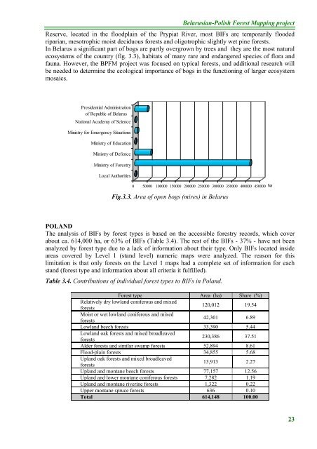
In Belarus a significant part of bogs are partly overgrown by trees and they are the most natural<br />
ecosystems of the country (fig. 3.3), habitats of many rare and endangered species of flora and<br />
fauna. However, the BPFM project was focused on typical forests, and additional research will<br />
be needed to determine the ecological importance of bogs in the functioning of larger ecosystem<br />
mosaics.<br />
Presidential Administration<br />
of Republic of Belarus<br />
National Academy of Science<br />
Ministry for Emergency Situations<br />
Ministry of Education<br />
Ministry of Defence<br />
Ministry of <strong>Forest</strong>ry<br />
Local Authorities<br />
0 50000 100000 150000 200000 250000 300000 350000 400000 450000 ha<br />
Fig.3.3. Area of open bogs (mires) in Belarus<br />
POLAND<br />
The analysis of BIFs by forest types is based on the accessible forestry records, which cover<br />
about ca. 614,000 ha, or 63% of BIFs (Table 3.4). The rest of the BIFs - 37% - have not been<br />
analyzed by forest type due to a lack of information about their type. Only BIFs located inside<br />
areas covered by Level 1 (stand level) numeric maps were analyzed. The reason for this<br />
limitation is that only forests on the Level 1 maps had a complete set of information for each<br />
stand (forest type and information about all criteria it fulfilled).<br />
Table 3.4. Contributions of individual forest types to BIFs in Poland.<br />
<strong>Forest</strong> type Area (ha) Share (%)<br />
Relatively dry lowland coniferous and mixed<br />
forests<br />
120,012 19.54<br />
Moist or wet lowland coniferous and mixed<br />
forests<br />
42,301 6.89<br />
Lowland beech forests 33,390 5.44<br />
Lowland oak forests and mixed broadleaved<br />
forests<br />
230,386 37.51<br />
Alder forests and similar swamp forests 52,894 8.61<br />
Flood-plain forests 34,855 5.68<br />
Upland oak forests and mixed broadleaved<br />
forests<br />
13,913 2.27<br />
Upland and montane beech forests 77,157 12.56<br />
Upland and lower montane coniferous forests 7,282 1.19<br />
Upland and montane riverine forests 1,322 0.22<br />
Upper montane spruce forests 636 0.10<br />
Total 614,148 100.00<br />
23


