

to download "Historic Landscape Characterisation (HLC) in Ireland ...
to download "Historic Landscape Characterisation (HLC) in Ireland ...
to download "Historic Landscape Characterisation (HLC) in Ireland ...

You also want an ePaper? Increase the reach of your titles
YUMPU automatically turns print PDFs into web optimized ePapers that Google loves.
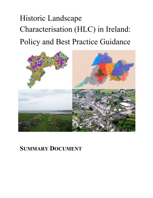
His<strong>to</strong>ric <strong>Landscape</strong><br />
<strong>Characterisation</strong> (<strong>HLC</strong>) <strong>in</strong> <strong>Ireland</strong>:<br />
Policy and Best Practice Guidance<br />
SUMMARY DOCUMENT
His<strong>to</strong>ric <strong>Landscape</strong> <strong>Characterisation</strong> <strong>in</strong> <strong>Ireland</strong>:<br />
Policy and Best Practice Guidance<br />
WHAT IS <strong>HLC</strong>?....................................................................................................................................... 1<br />
BENEFITS OF HISTORIC LANDSCAPE AND SEASCAPE CHARACTERISATION........................... 1<br />
THE <strong>HLC</strong> PROCESS .............................................................................................................................. 2<br />
STAGE A DEFINING THE OVERALL RATIONALE OF THE STUDY ................................................ 4<br />
STAGE B MAPPING AND DESCRIPTION .......................................................................................... 6<br />
STAGE C ASSESSMENT AND ANALYSIS......................................................................................... 8<br />
STAGE D MANAGEMENT ISSUES AND RECOMMENDATIONS .................................................... 10<br />
GENERAL ISSUES: DATA MANAGEMENT, ACCESS AND PRESENTATION................................ 11<br />
GENERIC HISTORIC CHARACTER TYPES (HCTS).......................................................................... 14<br />
FURTHER READING:........................................................................................................................... 15
His<strong>to</strong>ric <strong>Landscape</strong> <strong>Characterisation</strong> <strong>in</strong> <strong>Ireland</strong>:<br />
Policy and Best Practice Guidance<br />
What is <strong>HLC</strong>?<br />
His<strong>to</strong>ric <strong>Landscape</strong> <strong>Characterisation</strong> (<strong>HLC</strong>) is concerned with identify<strong>in</strong>g the contribution of<br />
the past <strong>to</strong> the present day landscape.<br />
All areas have some element of his<strong>to</strong>ric character, which contributes <strong>to</strong> their dist<strong>in</strong>ctiveness<br />
and people’s sense of place even where such character reflects major modern change.<br />
<strong>HLC</strong> is not particularly concerned with sites or monuments, although these can make an<br />
important contribution <strong>to</strong> character, just as their landscape sett<strong>in</strong>g is an important aspect of<br />
their his<strong>to</strong>ric <strong>in</strong>terest.<br />
<strong>HLC</strong> creates a seamless mosaic of his<strong>to</strong>ric character of the present day landscape. It beg<strong>in</strong>s<br />
with identification and description of character followed by assessments of value, sensitivity,<br />
significance and pressures. The first stage usually <strong>in</strong>volves identification of generic types of<br />
landscape which recur <strong>in</strong> different areas. These may comb<strong>in</strong>e <strong>to</strong>gether <strong>to</strong> create <strong>in</strong>dividual<br />
character areas, which are specific <strong>to</strong> the locality.<br />
A further stage of the <strong>HLC</strong> process will often <strong>in</strong>volve mak<strong>in</strong>g recommendations about how<br />
respect for the his<strong>to</strong>ric character of places can be built <strong>in</strong><strong>to</strong> strategies and decisions about<br />
future development or landuse, or enhanc<strong>in</strong>g public understand<strong>in</strong>g.<br />
Benefits of His<strong>to</strong>ric <strong>Landscape</strong> and Seascape <strong>Characterisation</strong><br />
<br />
<br />
<br />
<br />
<br />
<br />
<br />
<br />
Implementation of the European <strong>Landscape</strong> Convention at a local, regional and national level as a<br />
key plank of general landscape character Assessment (LCA) at regional county or local level<br />
<strong>HLC</strong> can form a robust basis for cover<strong>in</strong>g heritage issues <strong>in</strong> draft<strong>in</strong>g of Regional County and Local<br />
Development Plans and guidance and their associated Strategic Environmental Assessments<br />
Consideration of suitable locations for large-scale <strong>in</strong>frastructure projects <strong>in</strong>clud<strong>in</strong>g roads, bridges<br />
and w<strong>in</strong>d farms, etc;<br />
Provid<strong>in</strong>g a robust basis for assess<strong>in</strong>g <strong>in</strong>teractions of heritage, wildlife and landscape fac<strong>to</strong>rs <strong>in</strong><br />
EIAs of major developments or programme of landuse improvement.<br />
Regeneration of small <strong>to</strong>wns and villages <strong>in</strong> association with the preparation of Village Design<br />
Statements<br />
Target<strong>in</strong>g of landscape management <strong>in</strong>itiatives, REPS agri-environment schemes, rural<br />
regeneration, farm diversification and woodland expansion,;<br />
Assist<strong>in</strong>g development of design guidel<strong>in</strong>es for a wide range of developments from expansion of<br />
settlements and one-off rural hous<strong>in</strong>g <strong>to</strong> w<strong>in</strong>dfarms and other major <strong>in</strong>frastructure<br />
Input <strong>to</strong> Heritage Strategies, Local Action Plans and Tourism strategies<br />
Input <strong>to</strong> wider environmental <strong>in</strong>itiatives like Integrated Coastal Zone Management and Agenda 21;<br />
<br />
<br />
<br />
Inform the management of National Heritage Sites, Architectural Conservation Areas, Designed<br />
<strong>Landscape</strong>s etc<br />
Improv<strong>in</strong>g public awareness, appreciation and understand<strong>in</strong>g of his<strong>to</strong>ric landscape as a key part of<br />
people’s sense of place and identity.<br />
Provid<strong>in</strong>g a valuable <strong>to</strong>ol for further research <strong>in</strong><strong>to</strong> heritage at local, regional and national level.
The <strong>HLC</strong> Process<br />
Purpose of the Guidance<br />
This guidance is not prescriptive because his<strong>to</strong>ric characterisation can be undertaken at<br />
widely different scales and for many different purposes and applications.<br />
While not <strong>in</strong>tended <strong>to</strong> impose a uniform approach, the guidance does nevertheless seek <strong>to</strong><br />
establish some common pr<strong>in</strong>ciples and standards of his<strong>to</strong>ric characterisation that should<br />
ensure achievement of three important goals for any project:<br />
<br />
<br />
<br />
<strong>HLC</strong> is fit for purpose – both primary uses for which it was designed and what<br />
secondary uses or applications are also possible<br />
There is sufficient consistency of approach across different scales of<br />
assessment <strong>to</strong> provide a relatively seamless broad brush characterisation of<br />
large areas from separate studies<br />
Studies of large areas allow more detailed analysis and ref<strong>in</strong>ement at a more<br />
local level.<br />
Structure and Presentation of the Guidance<br />
The structure of the guidance reflects the expectation that it will be used <strong>to</strong> develop and<br />
execute specific projects, but these may differ significantly <strong>in</strong> purpose, and scale and <strong>in</strong> the<br />
type of environment be<strong>in</strong>g characterised.<br />
<strong>HLC</strong> is seen as a multi-stage process as illustrated <strong>in</strong> the Flow Chart on the page 3. There<br />
are four key Stages, <strong>to</strong>gether with a series of General Issues, which apply throughout the<br />
<strong>HLC</strong> process.<br />
While <strong>in</strong> many cases <strong>HLC</strong> studies will seek <strong>to</strong> complete all the stages of assessment, it is<br />
also recognised that some may be taken through only the <strong>in</strong>itial stages, while others might<br />
pick up at a later stage when the basel<strong>in</strong>e characterisation is complete, or when implications<br />
have been assessed. The Guidance sets out the issues that need <strong>to</strong> be considered under<br />
each of these broad <strong>to</strong>pics.<br />
A more detailed guidance document is also available <strong>in</strong> a separate document. Details of<br />
where <strong>to</strong> f<strong>in</strong>d this and selected other relevant documentation are given on page 15.<br />
135 o Panorama from Tulla churchyard, Co Clare show<strong>in</strong>g a variety of his<strong>to</strong>ric landscape<br />
characteristics and recent changes with<strong>in</strong> the sett<strong>in</strong>g of the ancient hill<strong>to</strong>p ecclesiastical centre<br />
2
Stage A Def<strong>in</strong><strong>in</strong>g the Overall Rationale of the Study<br />
Stage A ensures that there is clarity from the outset about the <strong>in</strong>tended purpose of the <strong>HLC</strong><br />
study, its relationship <strong>to</strong> other studies and <strong>to</strong> relevant Plans and Guidel<strong>in</strong>es. This enables the<br />
most appropriate geographical area and scale <strong>to</strong> be selected, and will ensure that the detailed<br />
methodology <strong>to</strong> be followed will meet user requirements.<br />
While some <strong>HLC</strong> studies will seek <strong>to</strong> complete all stages of assessment and analysis, others<br />
may only cover the <strong>in</strong>itial steps leav<strong>in</strong>g the more analytical assessment <strong>to</strong> be completed at a<br />
later stage. For example it may often be appropriate <strong>to</strong> take an <strong>in</strong>itial specialist study <strong>to</strong> the<br />
end of basel<strong>in</strong>e characterisation <strong>in</strong> Stage B, leav<strong>in</strong>g subsequent analysis and<br />
recommendations <strong>to</strong> be part of other <strong>in</strong>itiatives (eg broader landscape character assessment,<br />
prepar<strong>in</strong>g design guidel<strong>in</strong>es, development plan zon<strong>in</strong>g, or Environmental Assessment).<br />
<strong>HLC</strong> can serve many uses, <strong>in</strong>clud<strong>in</strong>g some which will be subsidiary <strong>to</strong> the ma<strong>in</strong> purpose of a<br />
study. Understand<strong>in</strong>g these uses is fundamental <strong>in</strong> choos<strong>in</strong>g the most appropriate<br />
methodology <strong>to</strong> characterise the area <strong>in</strong> question <strong>in</strong> ways that will helpfully <strong>in</strong>form future<br />
decision mak<strong>in</strong>g, research or public understand<strong>in</strong>g.<br />
Anaverna, Cooley Mounta<strong>in</strong>s, Co Louth show<strong>in</strong>g a wide variety of HL characteristics<br />
4
A1 Def<strong>in</strong><strong>in</strong>g the Nature of Project and End User Needs<br />
Def<strong>in</strong><strong>in</strong>g the purpose and potential users of the survey is crucial. These decisions <strong>in</strong>clude<br />
whether the <strong>HLC</strong> is a stand-alone <strong>in</strong>itiative or a contribution <strong>to</strong> wider <strong>Landscape</strong> Character<br />
Assessment. However, its scope should not be limited <strong>to</strong> one <strong>in</strong>tendeduse such if this<br />
<strong>in</strong>hibits the <strong>HLC</strong> contribut<strong>in</strong>g <strong>to</strong> other purposes.<br />
The pr<strong>in</strong>cipal uses for <strong>HLC</strong> are likely <strong>to</strong> be: strategic plann<strong>in</strong>g, development management,<br />
conservation management, outreach and education, academic research, and <strong>in</strong>creas<strong>in</strong>g<br />
public awareness. The role of public participation is vital and needs <strong>to</strong> be considered from<br />
the start of the <strong>HLC</strong> process.<br />
A2 Def<strong>in</strong><strong>in</strong>g the geographical context and scale of the study and its relationship <strong>to</strong><br />
others<br />
The <strong>in</strong>tended purpose of the study will determ<strong>in</strong>e its geographical area; whether it conforms<br />
with adm<strong>in</strong>istrative boundaries or an area def<strong>in</strong>ed for a particular purpose like a specific<br />
development proposal or research study. The purpose will also determ<strong>in</strong>e whether the scale<br />
is: national/regional; county; district or local. Other considerations for scale are the<br />
relationship with adjacent areas and other <strong>HLC</strong> and related studies, ensur<strong>in</strong>g that<br />
approaches are compatible.<br />
A3 Range and Levels of Detail Required <strong>in</strong> Assembl<strong>in</strong>g Basel<strong>in</strong>e Information<br />
The range of basel<strong>in</strong>e data sources <strong>to</strong> be consulted will vary accord<strong>in</strong>g <strong>to</strong> the purpose and<br />
scale of the study, but should <strong>in</strong>clude: <strong>to</strong>pographical context, his<strong>to</strong>ric landuse, morphology of<br />
enclosure and settlement, forms of boundaries, evidence for time-depth, his<strong>to</strong>ric background,<br />
adm<strong>in</strong>istration/tenure and cultural fac<strong>to</strong>rs.<br />
A4 Decid<strong>in</strong>g the Approach <strong>to</strong> Def<strong>in</strong><strong>in</strong>g His<strong>to</strong>ric <strong>Landscape</strong> Character<br />
Various mapp<strong>in</strong>g units can be used, typically based on: his<strong>to</strong>ric land use (e.g. groups of land<br />
parcels), his<strong>to</strong>ric resource management (e.g. <strong>to</strong>wnlands) or modern land management<br />
needs (e.g. Architectural Conservation Areas). Each approach has its strengths and the<br />
most appropriate need <strong>to</strong> be selected <strong>to</strong> suit the purpose of each study.<br />
GIS systems are typically used for mapp<strong>in</strong>g his<strong>to</strong>ric character units and must be designed so<br />
that all the attributes associated with them can be l<strong>in</strong>ked and <strong>in</strong>terogated. <strong>Characterisation</strong><br />
of small, pre-decided areas may be more purely descriptive and may not <strong>in</strong>volve GIS.<br />
A5 Def<strong>in</strong><strong>in</strong>g Relationships with Other Formal Plans or Guidel<strong>in</strong>es etc<br />
The <strong>HLC</strong> needs <strong>to</strong> be organised <strong>to</strong> allow it easily <strong>to</strong> supply the <strong>in</strong>formation necessary for<br />
LCA, SEA, Conservation Plans, research projects etc. It needs <strong>to</strong> address key<br />
characteristics, capacity for change and potential impacts, provid<strong>in</strong>g recommendations for<br />
address<strong>in</strong>g these issues, <strong>in</strong>clud<strong>in</strong>g possible mitigation and moni<strong>to</strong>r<strong>in</strong>g.<br />
5
Stage B Mapp<strong>in</strong>g and Description<br />
Stage B requires the collection of a wide range of basel<strong>in</strong>e data from which the key his<strong>to</strong>ric<br />
characteristics of the area can be identified and described and assimilated, usually <strong>in</strong><strong>to</strong> a<br />
database l<strong>in</strong>ked <strong>to</strong> digital mapp<strong>in</strong>g <strong>in</strong> a Geographic Information System (GIS).<br />
His<strong>to</strong>ric Character Types (HCTs) based on attributes of chronology, landuse, morphology or<br />
form, will need <strong>to</strong> be def<strong>in</strong>ed and mapped where studies cover large areas. Def<strong>in</strong>itions of HC<br />
Types may draw on a generic list, but should take <strong>in</strong><strong>to</strong> account any unusual and dist<strong>in</strong>ctive<br />
elements of the study area.<br />
His<strong>to</strong>ric character needs <strong>to</strong> be described as well as mapped and the use of GIS allows highly<br />
flexible analysis and group<strong>in</strong>g of characteristics. Consideration of a pilot area will often help<br />
<strong>to</strong> ref<strong>in</strong>e the methodology. On completion of mapp<strong>in</strong>g the distribution of these HCTs and<br />
their associated attributes will allow more general dist<strong>in</strong>ctive his<strong>to</strong>ric characteristics and<br />
relationships <strong>to</strong> be described.<br />
<strong>HLC</strong> mapp<strong>in</strong>g of Lough Currane area, Iveragh Pen<strong>in</strong>sula, Co Kerry<br />
6
B1 Detailed def<strong>in</strong>ition of area for mapp<strong>in</strong>g and any differences <strong>in</strong> levels of data<br />
collection<br />
The study area must be clearly def<strong>in</strong>ed, whether it is a s<strong>in</strong>gle block (e.g. county) or dispersed<br />
areas (e.g. f<strong>in</strong>d<strong>in</strong>g areas suitable for w<strong>in</strong>dfarms). It may be cost-effective <strong>to</strong> adopt a ‘nested’<br />
approach <strong>in</strong> which different levels of data are compiled <strong>to</strong> ensure clear focus on key issues<br />
(eg detailed exam<strong>in</strong>ation of development plan zones with<strong>in</strong> general <strong>HLC</strong> characterisation). If<br />
so, there must be a clear rationale and consistency of approach.<br />
B2 Identify<strong>in</strong>g access<strong>in</strong>g and import<strong>in</strong>g data sets<br />
The range of datasets available is extensive but should <strong>in</strong>clude: modern maps, aerial pho<strong>to</strong>s,<br />
geology and soils, his<strong>to</strong>ric maps, built environment and designed landscape, archaeological<br />
records, placenames, <strong>to</strong>wnland and other his<strong>to</strong>ric boundaries, habitats and nature reserves,<br />
and for seascape areas, charts, shipp<strong>in</strong>g data and wreck registers.<br />
B3 Def<strong>in</strong><strong>in</strong>g His<strong>to</strong>ric Character Types (HCTs)<br />
In many cases GIS is used <strong>to</strong> map areas that can be assigned different his<strong>to</strong>ric character<br />
types (HCTs). HCTs can be def<strong>in</strong>ed at various levels of detail accord<strong>in</strong>g <strong>to</strong> the scale of a<br />
project. Detailed categories need <strong>to</strong> capture local dist<strong>in</strong>ctiveness, but should also be<br />
compatible with a number of more widely applicable generic types (see Page 14).<br />
B4 His<strong>to</strong>ric Character Attributes and Dist<strong>in</strong>ctiveness<br />
The ma<strong>in</strong> attributes of how his<strong>to</strong>ric character is reflected through landscape features and<br />
relationships are landuse function, morphology, period, form and survival. These attributes<br />
should be recorded through descriptions and GIS attribute data.<br />
B5 Relict landscape and archaeological potential<br />
Coherent areas of earthworks or ru<strong>in</strong>s can often <strong>in</strong>fuence and may sometimes dom<strong>in</strong>ate<br />
landscape character and cultural associations. Almost any HCT may occur <strong>in</strong> a ‘relict’ form,<br />
add<strong>in</strong>g time depth and his<strong>to</strong>ric legibility <strong>to</strong> the landscape. Archaeological potential (known<br />
and suspected sites ) is another layer that can add depth of understand<strong>in</strong>g.<br />
B6 Cultural and associative landscape characteristics and their mapp<strong>in</strong>g<br />
Cultural, aesthetic and his<strong>to</strong>rical associations can contribute significantly <strong>to</strong> the his<strong>to</strong>ric<br />
character of an area and need <strong>to</strong> be considered. Approaches <strong>to</strong> mapp<strong>in</strong>g might <strong>in</strong>clude<br />
plott<strong>in</strong>g pilgrimage areas or def<strong>in</strong><strong>in</strong>g significant vistas or views. Other his<strong>to</strong>ric associations,<br />
placenames and family name associations may be described or given as attributes of places.<br />
B7 Work needed <strong>to</strong> enhance and validate desk-based analysis<br />
Once desk studies have been carried out and prelim<strong>in</strong>ary def<strong>in</strong>itions of HCTs drawn up these<br />
need <strong>to</strong> be tested <strong>in</strong> the field and ref<strong>in</strong>ed as appropriate. Consultation, with a wide range of<br />
stakeholders, is an important element of the characterisation process.<br />
B8 Identify<strong>in</strong>g what specific features are important <strong>in</strong> def<strong>in</strong><strong>in</strong>g his<strong>to</strong>ric dist<strong>in</strong>ctiveness<br />
For each HCT and HC Area key features that def<strong>in</strong>e his<strong>to</strong>ric dist<strong>in</strong>ctiveness should be<br />
identified. These might <strong>in</strong>clude monuments, patterns of settlement, vernacular architecture,<br />
his<strong>to</strong>ric landuses, shape size or form of enclosure, and a comb<strong>in</strong>ation of such fac<strong>to</strong>rs.<br />
7
Stage C Assessment and Analysis<br />
Stage C is concerned with assess<strong>in</strong>g the significance of the his<strong>to</strong>ric characteristics identified<br />
<strong>in</strong> Stage B and how this relates <strong>to</strong> past and ongo<strong>in</strong>g landscape change. In some studies<br />
areas compris<strong>in</strong>g several detailed HCTs will be comb<strong>in</strong>ed <strong>to</strong> def<strong>in</strong>e larger areas or zones<br />
that represent locally dist<strong>in</strong>ctive His<strong>to</strong>ric Character Areas (HCAs).<br />
Ongo<strong>in</strong>g and future trajec<strong>to</strong>ries of change should be identified and the sensitivity of the<br />
landscape assessed, tak<strong>in</strong>g <strong>in</strong><strong>to</strong> account both its <strong>in</strong>tr<strong>in</strong>sic his<strong>to</strong>ric <strong>in</strong>terest and value, and the<br />
survival condition and legibility of features and relationships that particularly contribute <strong>to</strong> the<br />
his<strong>to</strong>ric character of the area.<br />
Vulnerability <strong>to</strong> change can be exam<strong>in</strong>ed by tak<strong>in</strong>g account of the sensitivity of the his<strong>to</strong>ric<br />
landscape character, and exam<strong>in</strong><strong>in</strong>g how ongo<strong>in</strong>g and prospective trends and changes <strong>in</strong><br />
landuse and development imp<strong>in</strong>ge on the features and relationships that particularly<br />
contribute <strong>to</strong> the his<strong>to</strong>ric character locally dist<strong>in</strong>ctive areas. Some may be more robust than<br />
others, and positive benefits and opportunities as well as negative pressures should be<br />
considered.<br />
Changes <strong>in</strong> his<strong>to</strong>ric landscape coherence and <strong>in</strong>tegrity result<strong>in</strong>g from field boundary loss and<br />
clearance between 1964 and 1990 at Glanfahan, Co Kerry<br />
8
C1 Def<strong>in</strong><strong>in</strong>g the His<strong>to</strong>ric Character of Areas or Zones<br />
His<strong>to</strong>ric Character Types typically occur <strong>in</strong> several locations divid<strong>in</strong>g the study area <strong>in</strong><strong>to</strong><br />
many small units. Larger areas of broader his<strong>to</strong>ric character can be def<strong>in</strong>ed by comb<strong>in</strong><strong>in</strong>g<br />
HCTs or groups of <strong>to</strong>wnlands accord<strong>in</strong>g <strong>to</strong> broader patterns of recurr<strong>in</strong>g HCTs or other<br />
attributes (eg period, sensitivity), which can be useful <strong>in</strong> analys<strong>in</strong>g capacity for change.<br />
C2 Approach <strong>to</strong> Assess<strong>in</strong>g Heritage Values and Significance<br />
The significance of his<strong>to</strong>ric character can be considered <strong>in</strong> terms of two groups of values.<br />
Evidential values <strong>in</strong>clude criteria of period, survival and condition, rarity, coherence and<br />
group value and trajec<strong>to</strong>ries of change.<br />
Socio-economic and community values <strong>in</strong>clude Aesthetic and cultural value (his<strong>to</strong>rical,<br />
cultural and artistic association, visual qualities and design), Community values (education,<br />
sense of place, amenity and local dist<strong>in</strong>ctiveness), and Economic value (conservation-led<br />
regeneration, <strong>to</strong>urism, agricultural diversification).<br />
Overall the significance of a HC Type or HC Area can be considered <strong>in</strong> terms of the weight <strong>to</strong><br />
be given <strong>to</strong> different fac<strong>to</strong>rs <strong>in</strong> balanc<strong>in</strong>g these values and criteria. In do<strong>in</strong>g so professional<br />
judgement is needed, us<strong>in</strong>g both the his<strong>to</strong>ric landscape analysis and results of consultation.<br />
C3 Evidential Values<br />
<strong>Landscape</strong> change is much more piecemeal than broad categorisation of HCTs would<br />
suggest, and gradual modifications will eventually turn one type <strong>in</strong><strong>to</strong> another.<br />
Character that reflects older his<strong>to</strong>ric periods may be more significant than some more recent<br />
ones, but association with relatively recent key his<strong>to</strong>rical events or trends, such as the<br />
Fam<strong>in</strong>e and its aftermath, can also be very important <strong>in</strong> def<strong>in</strong><strong>in</strong>g his<strong>to</strong>ric landscape value.<br />
The completeness <strong>in</strong>tegrity and legibility of his<strong>to</strong>ric character depends partly on survival of<br />
elements (eg boundary removal; features <strong>in</strong> designed landscapes; urban plot shapes) and<br />
partly on physical condition (eg boundaries; effects of clearance, architectural modifications).<br />
C4 Socio-Economic and Community Values<br />
The contribution of his<strong>to</strong>rical and cultural associations may be recognised at a national,<br />
regional or local scale. The potential of associative values be<strong>in</strong>g used <strong>in</strong> <strong>to</strong>urism and the<br />
nature of events celebrat<strong>in</strong>g these associations are also important.<br />
Consultation with the local community will help <strong>to</strong> identify features seen as of particular value<br />
or characteristic of the area and its educational potential, and important local traditions.<br />
Both positive and negative aspects of economic values need <strong>to</strong> be considered <strong>in</strong> a context of<br />
his<strong>to</strong>ric change and opportunities (eg <strong>to</strong>urism, agriculture, forestry, hous<strong>in</strong>g, employment).<br />
C5 Synthesis<strong>in</strong>g Sensitivity and Vulnerability <strong>to</strong> Change<br />
Assess<strong>in</strong>g sensitivity needs <strong>to</strong> take account both of heritage and socio-economic values and<br />
of completeness and <strong>in</strong>tegrity of character <strong>to</strong> highlight areas where his<strong>to</strong>ric character is rare,<br />
especially dist<strong>in</strong>ctive, well-preserved, diverse, or with strong time-depth or associative value.<br />
Assess<strong>in</strong>g vulnerability <strong>to</strong> change needs <strong>to</strong> exam<strong>in</strong>e such sensitivity <strong>in</strong> relation <strong>to</strong> trends <strong>in</strong><br />
current and future opportunities and pressures that will affect his<strong>to</strong>ric character.<br />
9
Stage D Management Issues and Recommendations<br />
Stage D relates <strong>to</strong> proposals for manag<strong>in</strong>g the pressures and opportunities aris<strong>in</strong>g from<br />
changes that imp<strong>in</strong>ge on his<strong>to</strong>ric landscape character and sensitivity, and l<strong>in</strong>k<strong>in</strong>g these <strong>to</strong> the<br />
decision-mak<strong>in</strong>g process.<br />
Significant issues, opportunities and impacts need <strong>to</strong> be identified, allow<strong>in</strong>g proposals <strong>to</strong> be<br />
developed for implement<strong>in</strong>g and moni<strong>to</strong>r<strong>in</strong>g ways that valued his<strong>to</strong>ric characteristics of areas<br />
can be enhanced, protected and managed.<br />
<strong>HLC</strong> assessment will often be needed <strong>to</strong> <strong>in</strong>form the development of broader brush<br />
landscape characterisation as well as contribut<strong>in</strong>g <strong>to</strong> specific guidance on opportunities and<br />
constra<strong>in</strong>ts across many k<strong>in</strong>ds of development and other landuse change.<br />
Athenry Zon<strong>in</strong>g Map<br />
10
D1 Strategic Decision Mak<strong>in</strong>g Processes<br />
Many frameworks already exist for mak<strong>in</strong>g strategic decisions about the his<strong>to</strong>ric environment<br />
<strong>in</strong> conjunction with other management needs. They <strong>in</strong>clude strategic development plans and<br />
SEAs; Heritage plans; LCA assessments; Village Design Statements; Design Guidel<strong>in</strong>es;<br />
Agri-environment schemes; Forestry plann<strong>in</strong>g; and Integrated Coastal Zone Management.<br />
Assessments of impacts and recommendations for management need <strong>to</strong> be matched <strong>to</strong> the<br />
relevant tier(s) of decision-mak<strong>in</strong>g and the legislative requirements. For example, <strong>in</strong> SEAs<br />
actual changes <strong>to</strong> character aris<strong>in</strong>g from zon<strong>in</strong>g should be addressed.<br />
D2 Frameworks for Active Management of His<strong>to</strong>ric Character<br />
Ultimately changes <strong>in</strong> his<strong>to</strong>ric character are the cumulative result of <strong>in</strong>numerable localised,<br />
often very detailed decisions at a site-specific level. This is why the specific features and<br />
relationships that embody an area’s his<strong>to</strong>ric dist<strong>in</strong>ctiveness need <strong>to</strong> be identified and fed <strong>in</strong><strong>to</strong><br />
strategic frameworks that guide day-<strong>to</strong>-day development and landuse management. These<br />
<strong>in</strong>clude EIAs, agri-environment grant-giv<strong>in</strong>g, conservation plann<strong>in</strong>g and local outreach.<br />
Recommendations should address predicted k<strong>in</strong>ds of change <strong>in</strong> a robust, well-focussed, and<br />
practicable manner that is reasonable for developers, landowners and local communities.<br />
D3 Issues and Impact Assessment<br />
Development can profoundly change local his<strong>to</strong>ric landscape character and <strong>HLC</strong> can be a<br />
valuable <strong>to</strong>ol <strong>in</strong> assess<strong>in</strong>g and manag<strong>in</strong>g impacts. Change also happens more <strong>in</strong>sidiously<br />
though agricultural improvement.<br />
The ma<strong>in</strong> ways that his<strong>to</strong>ric character is changed are loss or addition of physical features;<br />
changes <strong>in</strong> condition; alterations affect<strong>in</strong>g coherence and <strong>in</strong>tegrity of character; severance of<br />
his<strong>to</strong>ric relationships, features or his<strong>to</strong>ric coherence; changes <strong>in</strong> visual appearance and<br />
alterations <strong>to</strong> views and vistas; other changes <strong>in</strong> perceptual values and his<strong>to</strong>ric associations.<br />
D4 Management, Implementation, Mitigation and Moni<strong>to</strong>r<strong>in</strong>g<br />
Implementation of management actions may be strategic (eg recommended plann<strong>in</strong>g<br />
policies, <strong>in</strong>put <strong>to</strong> design guidel<strong>in</strong>es, conservation plans) or site- specific (how actions seek <strong>to</strong><br />
res<strong>to</strong>re or improve character or how negative impacts can be avoided, reduced or modified).<br />
Such mechanisms must be related <strong>to</strong> the key his<strong>to</strong>ric landscape characteristics of the area<br />
and identified impacts or opportunities, and should be both robust and cost effective.<br />
In SEAs moni<strong>to</strong>r<strong>in</strong>g is <strong>to</strong>o often related <strong>to</strong> targets and performance <strong>in</strong>dica<strong>to</strong>rs that bear little<br />
or no relation <strong>to</strong> real changes <strong>in</strong> his<strong>to</strong>ric character. The pr<strong>in</strong>ciple should be <strong>to</strong> establish ways<br />
of directly moni<strong>to</strong>r<strong>in</strong>g actual change as identified by impact assessments, and <strong>to</strong> show how<br />
well decision-mak<strong>in</strong>g procedures deliver desired outcomes.<br />
D5 Integration with Other Guidance and Frameworks<br />
Although <strong>HLC</strong> does not figure <strong>in</strong> current guidance on <strong>Landscape</strong> Character Assessment or<br />
for SEAs and EIAs or other management frameworks, it offers important opportunities <strong>to</strong><br />
promote an <strong>in</strong>tegrated approach <strong>to</strong> susta<strong>in</strong>ability. This is implicit <strong>in</strong> how <strong>HLC</strong> should seek <strong>to</strong><br />
draw <strong>to</strong>gether a range of his<strong>to</strong>ric and socio-economic values of heritage with<strong>in</strong> wider<br />
landscape, wildlife and other environmental considerations.<br />
11
General Issues: Data Management, Access and Presentation<br />
Clear term<strong>in</strong>ology and mapp<strong>in</strong>g conventions are required and large amount of data<br />
generated, both <strong>in</strong> electronic and hard copy formats needs <strong>to</strong> be accessible for subsequent<br />
<strong>in</strong>terrogation or related studies, and should be archived <strong>to</strong> rema<strong>in</strong> accessible longer term.<br />
The format(s) chosen <strong>to</strong> communicate the results of <strong>HLC</strong> studies should address the needs<br />
of a wide range of potential users. The content design and legibility of maps and diagrams<br />
needs <strong>to</strong> be considered <strong>in</strong>clud<strong>in</strong>g detailed choices such as colour palettes.<br />
Public participation as well as formal consultation is vital <strong>to</strong> the success of <strong>HLC</strong>, process.<br />
GIS characterisation round Lough Currane, Co Kerry,shows HCT polygons (blue) and <strong>to</strong>wnland<br />
boundaries (p<strong>in</strong>k) on a digital his<strong>to</strong>ric OS 6” <strong>in</strong>ch map base with RMP data as spot symbols.<br />
12
G1 Consultation<br />
Consultation should be <strong>in</strong>tegral <strong>to</strong> all stages of the <strong>HLC</strong> process. At the outset it is important<br />
that the parameters of the study are established <strong>in</strong> consultation with those commission<strong>in</strong>g it.<br />
Wider participation of local communities, extend<strong>in</strong>g beyond formal consultation, has several<br />
potential benefits for the study. Methods of consultation may be varied but need <strong>to</strong> use best<br />
practice <strong>in</strong> public participation.<br />
G2 Data management<br />
<strong>HLC</strong> employs a wide range of datasets, many of them digital. GIS provides an effective<br />
approach <strong>to</strong> record<strong>in</strong>g and query<strong>in</strong>g large amounts of <strong>in</strong>formation, but for <strong>HLC</strong>s of small or<br />
uncomplicated areas, or where <strong>HLC</strong> seeks <strong>to</strong> enhance characterisation of pre-def<strong>in</strong>ed areas,<br />
a non-GIS approach may be appropriate. In either case, a comb<strong>in</strong>ation of text-based data,<br />
imagery and digital or hard copy mapp<strong>in</strong>g will be generated from which an accompany<strong>in</strong>g<br />
report will be developed.<br />
Data management procedures whether or not GIS based, need <strong>to</strong> be planned <strong>to</strong> allow<br />
creation of multiple layers of mapp<strong>in</strong>g and <strong>in</strong>terrogation of attributes l<strong>in</strong>ked <strong>to</strong> features with<strong>in</strong><br />
a particular layer. Technical term<strong>in</strong>ologies and mapp<strong>in</strong>g conventions should allow for a range<br />
of users, so that different types and levels of data are easily appreciated.<br />
G3 Report<strong>in</strong>g and Presentation<br />
While particular attention should be paid <strong>to</strong> the specific purpose and needs of the project, the<br />
various stages outl<strong>in</strong>ed above should be reflected <strong>in</strong> the structure of reports and explana<strong>to</strong>ry<br />
handbooks that accompany His<strong>to</strong>ric <strong>Characterisation</strong> studies.<br />
G4 Access<br />
Provision for access <strong>to</strong> <strong>HLC</strong> reports and GIS data should be decided from the outset. This<br />
may achieved through circulated reports, deposition <strong>in</strong> libraries and museums, local authority<br />
websites, pre-arranged access <strong>to</strong> GIS, CD copies, summary leaflets, pr<strong>in</strong>t on demand.<br />
G5 Presentation <strong>in</strong> reports<br />
<strong>HLC</strong> reports should adopt a logical order reflect<strong>in</strong>g the stages of the <strong>HLC</strong> process, presented<br />
<strong>in</strong> user-friendly form, accessible <strong>to</strong> non-specialists as well as experts. Key po<strong>in</strong>ts are not <strong>to</strong><br />
assume previous knowledge, us<strong>in</strong>g appendices for technical detail, cross-referenc<strong>in</strong>g<br />
between report and mapp<strong>in</strong>g, provid<strong>in</strong>g a glossary and l<strong>in</strong>ks <strong>to</strong> additional detail on websites.<br />
Reports should be illustrated with pho<strong>to</strong>graphs, copies of his<strong>to</strong>ric maps, graphs, diagrams<br />
and GIS generated mapp<strong>in</strong>g. The colours used <strong>in</strong> maps need <strong>to</strong> be chosen carefully so they<br />
are dist<strong>in</strong>guishable at most scales and are reproducible <strong>in</strong> pr<strong>in</strong>t. Keys are vital.<br />
Web-based GIS facilities will need <strong>to</strong> reflect the requirements of the commission<strong>in</strong>g body, but<br />
several features facilitat<strong>in</strong>g ease of use can be <strong>in</strong>corporated.<br />
G6 Archiv<strong>in</strong>g Data<br />
The location of both digital and non-digital archives should be determ<strong>in</strong>ed at the start of the<br />
project, ensur<strong>in</strong>g long-term capacity for s<strong>to</strong>rage and adherence <strong>to</strong> archival standards<br />
(electronic and hard copy). Archival arrangements should be expla<strong>in</strong>ed <strong>in</strong> <strong>HLC</strong> reports.<br />
13
Generic His<strong>to</strong>ric Character Types (HCTs)<br />
The follow<strong>in</strong>g His<strong>to</strong>ric Character Types are <strong>in</strong>tended <strong>to</strong> be applicable <strong>to</strong> any <strong>HLC</strong> study and<br />
may be divided <strong>in</strong><strong>to</strong> more numerous sub-types <strong>to</strong> provide more detailed resolution of<br />
character (see ma<strong>in</strong> Policy and Good Practice Guidance document for some <strong>in</strong>dicative<br />
specific types with<strong>in</strong> these categories).<br />
While they can be grouped under their head<strong>in</strong>gs <strong>to</strong> provide a broader brush classification,<br />
this is mov<strong>in</strong>g the character more <strong>to</strong>wards simple landcover than his<strong>to</strong>ric dist<strong>in</strong>ctiveness.<br />
C Coastal<br />
CU Coastal: upland and hard rock<br />
character<br />
CL Coastal: lowland and soft rock<br />
character<br />
W Water<br />
WN Natural <strong>in</strong>land water bodies<br />
WA Artificial water bodies<br />
B Bog<br />
BB Blanket bog<br />
BR Raised Bog<br />
O Open rough ground and commons<br />
OR Open upland rough ground<br />
OE Semi-open rough ground (open<br />
ground divided by large enclosures)<br />
and scrub<br />
OC Open lowland commons<br />
T Trees and Woodland<br />
TW – Ancient and mixed woodland<br />
TP – Plantation woodland and forest<br />
F Fields<br />
FA – Ancient fields<br />
FH – His<strong>to</strong>ric fields of dist<strong>in</strong>ct character<br />
FI – S<strong>in</strong>uous bounded and irregular fields<br />
FS – Straight sided and surveyed<br />
rectil<strong>in</strong>ear fields<br />
FM –Fields of mixed orig<strong>in</strong> or result<strong>in</strong>g<br />
from boundary loss<br />
FO – Other fields for specialist productive<br />
uses<br />
P Parks and Demesne <strong>Landscape</strong><br />
PF – Demesne farmland<br />
PP – Designed parks and gardens<br />
PD – Deer Park<br />
D Devotional Ceremonial and Funerary<br />
DR Devotional Religious complex<br />
DF Devotional funerary only<br />
DC Ceremonial<br />
S Settlement <strong>in</strong> Rural areas<br />
SM Medieval rural settlements<br />
SV Settlements of ‘village’ form<br />
SC Settlement clusters of particular<br />
his<strong>to</strong>ric forms<br />
SS Other street-form and l<strong>in</strong>ear<br />
settlements<br />
ST Late 19 th and 20 th century and recent<br />
rural settlement<br />
U Urban Settlement<br />
UM Urban Medieval<br />
UP Urban post medieval<br />
UV Urban Vic<strong>to</strong>rian and Edwardian<br />
UT Urban mid <strong>to</strong> late 20 th cent<br />
UR Urban recent<br />
I Industry and Commerce<br />
IL Light <strong>in</strong>dustry and commerce<br />
IC Major Industry and commerce<br />
U Utilities and Infrastructure<br />
UE Utilities (electricity and<br />
telecommunications)<br />
UI Utilities (term<strong>in</strong>al based <strong>in</strong>frastructure)<br />
E Extractive Industry and Landfill<br />
EX M<strong>in</strong>eral extraction<br />
EP Peat extraction<br />
EW Landfill<br />
C Communication and transport<br />
CR L<strong>in</strong>ear communication routes and<br />
associated <strong>in</strong>frastructure<br />
CA Area communication and transport<br />
M Military<br />
MF Military fortifications & batteries<br />
MS Military support facilities<br />
R Recreation Sport and Tourism<br />
RS Recreational sports<br />
RT Recreational <strong>to</strong>urism<br />
14
His<strong>to</strong>ric <strong>Landscape</strong> <strong>Characterisation</strong> <strong>in</strong> <strong>Ireland</strong>:<br />
Policy and Best Practice Guidance<br />
His<strong>to</strong>ric <strong>Landscape</strong> <strong>Characterisation</strong> (<strong>HLC</strong>) is concerned with identify<strong>in</strong>g the<br />
contribution of the past <strong>to</strong> the present day landscape. It can be applied anywhere and<br />
can contribute substantially <strong>to</strong> improved understand<strong>in</strong>g of and conservation of the<br />
his<strong>to</strong>ric dist<strong>in</strong>ctiveness of landscape and places. This can be achieved through a range of<br />
different applications benefit<strong>in</strong>g many different users. This Guidance is designed <strong>to</strong> help<br />
those commission<strong>in</strong>g or carry<strong>in</strong>g out <strong>HLC</strong> <strong>to</strong> ensure that the results are robust, flexible<br />
and reasonable and clear <strong>to</strong> users. More detailed guidance and <strong>in</strong>formation on the<br />
background <strong>to</strong> <strong>HLC</strong> is available, <strong>in</strong>clud<strong>in</strong>g the documents listed below.<br />
The multi-period landscape around Strokes<strong>to</strong>wn House and village Co. Roscommon<br />
Further Read<strong>in</strong>g:<br />
Atlas of the Rural Irish <strong>Landscape</strong> (Aalen, F.H.A., Whelan, K. and S<strong>to</strong>ut, M.(eds),1997)<br />
European <strong>Landscape</strong> Convention (www.coe.<strong>in</strong>t/T/E/cultural-co-operation/Environmental/<strong>Landscape</strong><br />
National Heritage Plan 2002 (Government of <strong>Ireland</strong>)<br />
<strong>Landscape</strong> Guidel<strong>in</strong>es(Julie Mart<strong>in</strong> Associates with Alison Farmer Associates 2006, Heritage Council)<br />
His<strong>to</strong>ric <strong>Landscape</strong> <strong>Characterisation</strong> <strong>in</strong> <strong>Ireland</strong>: Policy and Best Practice Guidance (Oxford<br />
Archaeology & George Lambrick HeritageConsultancy, Heritage Council)<br />
Review of Irish His<strong>to</strong>ric <strong>Landscape</strong> <strong>Characterisation</strong> (Oxford Archaeology & George Lambrick<br />
HeritageConsultancy, Heritage Council)<br />
15


