Township of Rockaway DRAFT Highlands Element for Municipal ...
Township of Rockaway DRAFT Highlands Element for Municipal ...
Township of Rockaway DRAFT Highlands Element for Municipal ...

Create successful ePaper yourself
Turn your PDF publications into a flip-book with our unique Google optimized e-Paper software.
<strong>DRAFT</strong> FOR PUBLIC COMMENT<br />
Please Note: This document should be read in concert with the Final Draft<br />
Consistency Review and Recommendations Report prepared by <strong>Highlands</strong><br />
Council Staff <strong>for</strong> <strong>Rockaway</strong> <strong>Township</strong>.<br />
Prior to adoption: a) this cover page will be replaced in its entirety with one<br />
using the municipality’s <strong>for</strong>matting and logo; b) the document will be<br />
finalized; and c) all instructional text will be removed.<br />
<strong>Township</strong> <strong>of</strong> <strong>Rockaway</strong><br />
<strong>DRAFT</strong> <strong>Highlands</strong> <strong>Element</strong> <strong>for</strong><br />
<strong>Municipal</strong> Master Plan<br />
Prepared by the State <strong>of</strong> New Jersey <strong>Highlands</strong> Water Protection and<br />
Planning Council in Support <strong>of</strong> the <strong>Highlands</strong> Regional Master Plan<br />
November 2010
HIGHLANDS ELEMENT<br />
<strong>DRAFT</strong> MASTER PLAN SUPPLEMENT<br />
TOWNSHIP OF ROCKAWAY<br />
MORRIS COUNTY, NEW JERSEY<br />
<strong>DRAFT</strong> FOR SUBMISSION TO THE NEW JERSEY HIGHLANDS WATER<br />
PROTECTION AND PLANNING COUNCIL TOWARD ACHIEVING PLAN<br />
CONFORMANCE WITH THE HIGHLANDS REGIONAL MASTER PLAN<br />
PLANNING BOARD<br />
Morton Dicker, Chairperson<br />
David Washington, Secretary<br />
Louis S. Sceusi, Mayor<br />
John DiMaria, Councilman<br />
Carolyn Keegan<br />
Robert Santoro<br />
Joseph Chovanec<br />
Frank Barilla<br />
Vincent Brennan<br />
John Quinn<br />
James Kickham, Alternate #1<br />
Jack Elko, Alternate #2<br />
The Planning Board presented, discussed, and accepted public comment on this draft<br />
Master Plan supplement at its duly-noticed public meeting <strong>of</strong> August 17, 2009. Copies <strong>of</strong> the<br />
document were made available <strong>for</strong> review by the public at least 10 days prior to that<br />
meeting, and adequate notice <strong>of</strong> the meeting advising that the <strong>Highlands</strong> <strong>Element</strong> was on<br />
the agenda <strong>for</strong> discussion and public comment, was provided.<br />
This document is based on a model <strong>Highlands</strong> <strong>Element</strong> prepared and provided to all<br />
<strong>Highlands</strong> municipalities by the New Jersey <strong>Highlands</strong> Water Protection and Planning<br />
Council. Modifications required to tailor it <strong>for</strong> application to the <strong>Township</strong> <strong>of</strong> <strong>Rockaway</strong><br />
were provided by the individual indicated below.<br />
PREPARED BY:<br />
Joseph H. Burgis, PP, AICP Pr<strong>of</strong>essional License No. 2450
<strong>DRAFT</strong> <strong>Highlands</strong> <strong>Element</strong> to the <strong>Rockaway</strong> <strong>Township</strong> Master Plan November 2010<br />
TABLE OF CONTENTS<br />
INTRODUCTION ........................................................................................................................................................... 3<br />
POLICIES, GOALS & OBJECTIVES ........................................................................................................................ 5<br />
A. PRESERVATION AREA GOALS ............................................................................................................... 5<br />
B. PLANNING AREA GOALS .......................................................................................................................... 6<br />
C. GENERAL PURPOSES OF ZONING ....................................................................................................... 6<br />
D. RELATIONSHIP BETWEEN HIGHLANDS ACT & MLUL ............................................................ 8<br />
LAND USE PLAN ........................................................................................................................................................ 10<br />
A. HIGHLANDS ZONES AND SUB-ZONES............................................................................................ 10<br />
B. LAND USES ................................................................................................................................................... 11<br />
C. DENSITY AND INTENSITY OF DEVELOPMENT ......................................................................... 13<br />
D. CLUSTER DEVELOPMENT .................................................................................................................... 17<br />
E. LAND USE INVENTORY .......................................................................................................................... 18<br />
F. REDEVELOPMENT PLANNING........................................................................................................... 18<br />
HOUSING PLAN.......................................................................................................................................................... 22<br />
CONSERVATION PLAN .......................................................................................................................................... 23<br />
A. FOREST RESOURCES ............................................................................................................................... 23<br />
B. HIGHLANDS OPEN WATERS AND RIPARIAN AREAS............................................................. 24<br />
C. STEEP SLOPES ............................................................................................................................................ 26<br />
D. CRITICAL HABITAT .................................................................................................................................. 27<br />
E. CARBONATE ROCK ................................................................................................................................... 29<br />
F. LAKE MANAGEMENT .............................................................................................................................. 30<br />
G. WATER RESOURCES AVAILABILITY............................................................................................... 32<br />
H. PRIME GROUND WATER RECHARGE AREAS ............................................................................. 34<br />
I. WATER QUALITY ...................................................................................................................................... 35<br />
J. WELLHEAD PROTECTION .................................................................................................................... 36<br />
K. LOW IMPACT DEVELOPMENT ........................................................................................................... 39<br />
UTILITY SERVICES PLAN ..................................................................................................................................... 41<br />
A. PRESERVATION AREA ............................................................................................................................ 41<br />
B. PLANNING AREA ....................................................................................................................................... 41<br />
C. PLANNING & PRESERVATION AREAS ........................................................................................... 42<br />
- 1 -
<strong>DRAFT</strong> <strong>Highlands</strong> <strong>Element</strong> to the <strong>Rockaway</strong> <strong>Township</strong> Master Plan November 2010<br />
CIRCULATION PLAN ............................................................................................................................................... 44<br />
LAND PRESERVATION AND LAND STEWARDSHIP PLAN .................................................................. 47<br />
COMMUNITY FACILITIES PLAN........................................................................................................................ 50<br />
SUSTAINABLE ECONOMIC DEVELOPMENT PLAN ................................................................................. 51<br />
HISTORIC PRESERVATION PLAN .................................................................................................................... 52<br />
A. HISTORIC, CULTURAL, AND ARCHAEOLOGICAL RESOURCES.......................................... 52<br />
B. SCENIC RESOURCES ................................................................................................................................ 54<br />
DEVELOPMENT TRANSFER PLAN .................................................................................................................. 56<br />
RELATIONSHIP OF MASTER PLAN TO STATE/REGIONAL/LOCAL PLANS ............................... 58<br />
ACRONYMS .................................................................................................................................................................. 60<br />
EXHIBITS ...................................................................................................................................................................... 61<br />
APPENDIX A MAJOR POTENTIAL CONTAMINANT SOURCES ....................................................... 94<br />
APPENDIX B MINOR POTENTIAL CONTAMINANT SOURCES ....................................................... 96<br />
APPENDIX C MAJOR POTENTIAL POLLUTANT SOURCES ............................................................... 97<br />
- 2 -
<strong>DRAFT</strong> <strong>Highlands</strong> <strong>Element</strong> to the <strong>Rockaway</strong> <strong>Township</strong> Master Plan November 2010<br />
INTRODUCTION<br />
The <strong>Township</strong> <strong>of</strong> <strong>Rockaway</strong> is located in the New Jersey <strong>Highlands</strong> Region. It is one <strong>of</strong> 88<br />
municipalities protected by and subject to the provisions <strong>of</strong> the <strong>Highlands</strong> Water Protection<br />
and Planning Act (“<strong>Highlands</strong> Act,” N.J.S.A. 13:20-1 et seq.). The <strong>Highlands</strong> Act was enacted<br />
by the State Legislature on August 10, 2004 <strong>for</strong> the purpose <strong>of</strong> protecting, enhancing, and<br />
restoring <strong>Highlands</strong> natural resources, in particular water resources, which provide<br />
drinking water to over 5 million New Jersey residents. The <strong>Highlands</strong> Act created the<br />
<strong>Highlands</strong> Water Protection and Planning Council (the “<strong>Highlands</strong> Council”) and charged it<br />
with crafting a comprehensive master plan <strong>for</strong> the <strong>Highlands</strong> Region.<br />
To complete that task, the <strong>Highlands</strong> Council engaged in a four-year planning process<br />
involving extensive scientific and technical analysis <strong>of</strong> the Region, along with an intensive<br />
program <strong>of</strong> public outreach and participation. The <strong>Highlands</strong> Council solicited the advice<br />
and input <strong>of</strong> all stakeholders and interested parties through a variety <strong>of</strong> means, including<br />
but not limited to: initiation <strong>of</strong> the “Partnership Program” <strong>for</strong> municipal and county<br />
government representatives; <strong>for</strong>mation <strong>of</strong> 18 Technical Advisory Committees comprised <strong>of</strong><br />
technical experts and practitioners in relevant fields such as land use planning, engineering,<br />
agriculture, real estate appraisal, transportation, and business; and development <strong>of</strong> the<br />
“Network,” a <strong>for</strong>um <strong>for</strong> in<strong>for</strong>mation-sharing and outreach to the general public. In addition,<br />
the <strong>Highlands</strong> Council has held and continues to adhere to a regular schedule <strong>of</strong> open public<br />
meetings providing continuous opportunity <strong>for</strong> public comment, and has provided <strong>for</strong> ongoing<br />
data sharing and access to in<strong>for</strong>mation through its internet website.<br />
The <strong>Highlands</strong> Regional Master Plan (RMP) was adopted by the <strong>Highlands</strong> Council on July<br />
17, 2008, and became effective on September 8, 2008. As the product <strong>of</strong> a long-term,<br />
participatory, and region-wide planning ef<strong>for</strong>t, the RMP is representative <strong>of</strong> the collective<br />
response <strong>of</strong> the wider community to the Legislature’s call <strong>for</strong> a <strong>Highlands</strong> comprehensive<br />
master plan. The <strong>Township</strong> places value in the regional planning process that was<br />
undertaken to fully develop the RMP and acknowledges its role in furthering the vision that<br />
it represents.<br />
The <strong>Highlands</strong> Region encompasses some 1,343 square miles in the northwest part <strong>of</strong> New<br />
Jersey. The <strong>Highlands</strong> Act designates about half <strong>of</strong> the seven-county Region as Preservation<br />
Area (415,000 acres) and the other half as Planning Area (445,000 acres). The Act requires<br />
that jurisdictions having lands in the Preservation Area con<strong>for</strong>m to the <strong>Highlands</strong> RMP with<br />
respect to that area, while <strong>for</strong> lands located in the Planning Area, con<strong>for</strong>mance is voluntary.<br />
The <strong>Township</strong> <strong>of</strong> <strong>Rockaway</strong> is located partially in each, the Preservation and Planning Area.<br />
The municipality affirmatively seeks to align its land use planning program with the<br />
provisions <strong>of</strong> the RMP with respect to the whole <strong>of</strong> the municipality. For purposes <strong>of</strong> this<br />
document, these lands shall hence<strong>for</strong>th be referred to as the “<strong>Township</strong> <strong>Highlands</strong> Area.” As<br />
to voluntary con<strong>for</strong>mance <strong>for</strong> the Planning Area, the Governing Body adopted General<br />
Ordinance #____ on ___ (insert date) [<strong>Township</strong> will insert prior to adoption] indicating its<br />
intention to revise the municipal Master Plan and development ordinances, as applicable to<br />
- 3 -
<strong>DRAFT</strong> <strong>Highlands</strong> <strong>Element</strong> to the <strong>Rockaway</strong> <strong>Township</strong> Master Plan November 2010<br />
the development and use <strong>of</strong> land in the Planning Area, to con<strong>for</strong>m with the goals,<br />
requirements, and provisions <strong>of</strong> the <strong>Highlands</strong> RMP.) This supplement to the <strong>Township</strong><br />
Master Plan, designated the “<strong>Highlands</strong> <strong>Element</strong>,” represents a first step toward achieving<br />
full con<strong>for</strong>mance with the <strong>Highlands</strong> RMP.<br />
The <strong>Highlands</strong> <strong>Element</strong> sets <strong>for</strong>th the policies that shall guide the future land use and<br />
development <strong>of</strong> the <strong>Township</strong> <strong>Highlands</strong> Area. It provides the rationale and the framework<br />
<strong>for</strong> the adoption <strong>of</strong> land use regulations that are protective <strong>of</strong> <strong>Highlands</strong> resources and<br />
consistent with the <strong>Highlands</strong> RMP. With regard to specific regulatory requirements, these<br />
shall apply primarily (but not exclusively) to non-exempt land use activities in the<br />
<strong>Highlands</strong> Area. “Non-exempt” land use and development refers to uses, activities, and<br />
development projects not expressly listed as exemptions in the <strong>Highlands</strong> Act (N.J.S.A.<br />
13:20-28). <strong>Highlands</strong> Act exemptions pertain to specific “activities, improvements and<br />
development projects.” With the exception <strong>of</strong> the lands <strong>of</strong> federal military installations<br />
existing at the time <strong>of</strong> enactment <strong>of</strong> the <strong>Highlands</strong> Act, the exemptions do not apply acrossthe-board<br />
to lots, tracts, or any other divisions <strong>of</strong> land, whether existing or proposed at the<br />
time <strong>of</strong> passage <strong>of</strong> the Act. Land use activities, improvements, and development projects<br />
that are exempt from the <strong>Highlands</strong> Act shall remain subject to all other applicable<br />
provisions <strong>of</strong> the underlying municipal Master Plan, Zoning and Land Use Ordinances, and<br />
Development Regulations.<br />
The <strong>Highlands</strong> <strong>Element</strong> amends or creates in limited <strong>for</strong>m (where not already existing),<br />
each <strong>of</strong> the components <strong>of</strong> the municipal Master Plan, as provided in the sections that<br />
follow. The <strong>Highlands</strong> <strong>Element</strong> is intended to apply in conjunction with the language <strong>of</strong> the<br />
existing <strong>Township</strong> Master Plan to the maximum extent feasible. In the event <strong>of</strong> conflicts<br />
between the two, the <strong>Highlands</strong> <strong>Element</strong> shall supersede, unless the existing municipal<br />
Master Plan provisions are more restrictive.<br />
- 4 -
<strong>DRAFT</strong> <strong>Highlands</strong> <strong>Element</strong> to the <strong>Rockaway</strong> <strong>Township</strong> Master Plan November 2010<br />
POLICIES, GOALS & OBJECTIVES<br />
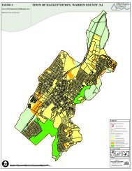
The <strong>Township</strong> <strong>Highlands</strong> Area encompasses the whole <strong>of</strong> the municipality. It consists <strong>of</strong><br />
approximately 29,405 acres <strong>of</strong> land (see Exhibit A, <strong>Township</strong> <strong>Highlands</strong> Area). Of the total<br />
acreage, approximately 17,823 acres (60.6 percent) lies within the <strong>Highlands</strong> Preservation<br />
Area while 11,582 acres (39.4 percent) lies within the Planning Area.<br />
The <strong>Township</strong> Environmental Resource Inventory (ERI) (prepared by Burgis Associates,<br />
and dated June 2009) [<strong>Township</strong> will update when final] provides detailed in<strong>for</strong>mation<br />
concerning the physical features, natural resources and specific characteristics <strong>of</strong> the<br />
municipal <strong>Highlands</strong> Area. The municipal ERI includes all <strong>of</strong> the in<strong>for</strong>mation available<br />
through the <strong>Highlands</strong> Regional Master Plan and supporting technical documents, which<br />
document the wide array <strong>of</strong> natural and cultural resources that characterize the New Jersey<br />
<strong>Highlands</strong> Region.<br />
The municipality recognizes the unique value <strong>of</strong> the <strong>Township</strong> <strong>Highlands</strong> Area and seeks to<br />
protect and enhance it, in keeping with the <strong>Highlands</strong> Act and the <strong>Highlands</strong> RMP.<br />
Accordingly, the overarching land use policy with respect to the <strong>Township</strong> <strong>Highlands</strong> Area<br />
is to place priority emphasis on the protection, enhancement and restoration <strong>of</strong> <strong>Highlands</strong><br />
natural and cultural resources while ensuring that land use and development activities<br />
therein occur only in a manner and location that is consistent with the <strong>Highlands</strong> RMP.<br />
In keeping with this policy, the following goals <strong>of</strong> the <strong>Highlands</strong> Act and <strong>Highlands</strong> RMP are<br />
embraced by the municipality and shall guide the land use and development <strong>of</strong> the<br />
<strong>Township</strong> <strong>Highlands</strong> Area:<br />
A. PRESERVATION AREA GOALS<br />
1. To protect, restore, and enhance the quality and quantity <strong>of</strong> surface and ground<br />
waters;<br />
2. To preserve extensive and, to the maximum extent possible, contiguous areas <strong>of</strong><br />
land in its natural state, thereby ensuring retention <strong>of</strong> the unique and significant<br />
natural, scenic, and other resources representative <strong>of</strong> the <strong>Township</strong> <strong>Highlands</strong> Area;<br />
3. To protect the natural, scenic, and other resources <strong>of</strong> the <strong>Township</strong> <strong>Highlands</strong> Area,<br />
including but not limited to contiguous <strong>for</strong>ests, wetlands, vegetated stream<br />
corridors, steep slopes, and critical habitat <strong>for</strong> fauna and flora;<br />
4. To preserve farmland, historic sites, and other historic resources;<br />
5. To preserve outdoor recreation opportunities on publicly owned land;<br />
6. To promote conservation <strong>of</strong> water resources;<br />
7. To promote Brownfield remediation and redevelopment, where applicable;<br />
- 5 -
<strong>DRAFT</strong> <strong>Highlands</strong> <strong>Element</strong> to the <strong>Rockaway</strong> <strong>Township</strong> Master Plan November 2010<br />
8. To promote compatible agricultural, horticultural, recreational, and cultural uses<br />
and opportunities within the framework <strong>of</strong> protecting the environment <strong>of</strong> the<br />
<strong>Township</strong> <strong>Highlands</strong> Area; and<br />
9. To prohibit or limit to the maximum extent possible construction or development<br />
which is incompatible with preservation <strong>of</strong> this unique area.<br />
B. PLANNING AREA GOALS<br />
1. To protect, restore, and enhance the quality and quantity <strong>of</strong> surface and ground<br />
waters;<br />
2. To preserve to the maximum extent possible any environmentally sensitive lands<br />
and other lands needed <strong>for</strong> recreation and conservation purposes;<br />
3. To protect and maintain the essential character <strong>of</strong> the <strong>Township</strong> <strong>Highlands</strong> Area<br />
environment;<br />
4. To preserve farmland, historic sites, and other historic resources;<br />
5. To promote the continuation and expansion <strong>of</strong> agricultural, horticultural,<br />
recreational, and cultural uses and opportunities;<br />
6. To preserve outdoor recreation opportunities on publicly owned land;<br />
7. To promote conservation <strong>of</strong> water resources;<br />
8. To promote Brownfield remediation and redevelopment, where applicable;<br />
9. To encourage as applicable, and consistent with the State Development and<br />
Redevelopment Plan and smart growth strategies and principles, appropriate<br />
patterns <strong>of</strong> compatible residential, commercial, and industrial development,<br />
redevelopment, and economic growth, in or adjacent to areas already utilized <strong>for</strong><br />
such purposes, and to discourage piecemeal, scattered, and inappropriate<br />
development, in order to accommodate local growth and economic development in<br />
an orderly way while protecting the <strong>Township</strong> <strong>Highlands</strong> Area environment from<br />
the individual and cumulative adverse impacts there<strong>of</strong>; and<br />
10. To the extent applicable: To promote local transportation opportunities that are<br />
consistent with smart growth strategies and principles.<br />
C. GENERAL PURPOSES OF ZONING<br />
The a<strong>for</strong>e-listed goals <strong>for</strong> the use and development <strong>of</strong> lands located within the <strong>Township</strong><br />
<strong>Highlands</strong> Area are consistent with and intended to apply equally and in conjunction with<br />
the purposes <strong>of</strong> zoning as expressed by the New Jersey <strong>Municipal</strong> Land Use Law (MLUL)<br />
(N.J.S.A. 40:55D-1 et seq.). Nothing in the body <strong>of</strong> the <strong>Highlands</strong> <strong>Element</strong> shall be construed<br />
- 6 -
<strong>DRAFT</strong> <strong>Highlands</strong> <strong>Element</strong> to the <strong>Rockaway</strong> <strong>Township</strong> Master Plan November 2010<br />
to imply that the provisions <strong>of</strong> the MLUL are not also applicable to the <strong>Township</strong> in<br />
exercising its authority to engage in land use planning and regulation pertinent to the<br />
<strong>Highlands</strong> Area.<br />
The intents and purposes <strong>of</strong> the MLUL (N.J.S.A. 40:55D-2) are expressly incorporated herein<br />
<strong>for</strong> application to <strong>Township</strong> land use planning and management <strong>of</strong> the <strong>Highlands</strong> Area, as<br />
follows:<br />
a. To guide the appropriate use or development <strong>of</strong> all lands under <strong>Township</strong><br />
jurisdiction, in a manner which will promote the public health, safety, morals,<br />
and general welfare;<br />
b. To secure safety from fire, flood, panic and other natural and man-made<br />
disasters;<br />
c. To provide adequate light, air and open space;<br />
d. To ensure that the development <strong>of</strong> the <strong>Township</strong> does not conflict with the<br />
development and general welfare <strong>of</strong> neighboring municipalities, the county, or<br />
the state as a whole;<br />
e. To promote the establishment <strong>of</strong> appropriate population densities and<br />
concentrations that will contribute to the well-being <strong>of</strong> persons, neighborhoods,<br />
communities and regions and preservation <strong>of</strong> the environment;<br />
f. To encourage the appropriate and efficient expenditure <strong>of</strong> public funds by the<br />
coordination <strong>of</strong> public development with land use policies;<br />
g. To provide sufficient space in appropriate locations <strong>for</strong> a variety <strong>of</strong> agricultural,<br />
residential, recreational, commercial and industrial uses and open space, both<br />
public and private, according to their respective environmental requirements in<br />
order to meet the needs <strong>of</strong> all citizens;<br />
h. To encourage the location and design <strong>of</strong> transportation routes which will<br />
promote the free flow <strong>of</strong> traffic while discouraging location <strong>of</strong> such facilities and<br />
routes which result in congestion or blight;<br />
i. To promote a desirable visual environment through creative development<br />
techniques and good civic design and arrangement;<br />
j. To promote the conservation <strong>of</strong> historic sites and districts, open space, energy<br />
resources and valuable natural resources in the <strong>Township</strong> and to prevent urban<br />
sprawl and degradation <strong>of</strong> the environment through improper use <strong>of</strong> land;<br />
k. To encourage planned unit developments, where appropriate, which<br />
incorporate the best features <strong>of</strong> design and relate the type, design and layout <strong>of</strong><br />
residential, commercial, industrial and/or recreational development to the<br />
particular site;<br />
- 7 -
<strong>DRAFT</strong> <strong>Highlands</strong> <strong>Element</strong> to the <strong>Rockaway</strong> <strong>Township</strong> Master Plan November 2010<br />
l. To ensure sufficient availability <strong>of</strong> senior citizen community housing;<br />
m. To encourage coordination <strong>of</strong> the various public and private procedures and<br />
activities shaping land development with a view <strong>of</strong> lessening the cost <strong>of</strong> such<br />
development and to the more efficient use <strong>of</strong> land;<br />
n. To promote utilization <strong>of</strong> renewable energy resources; and<br />
o. To promote the maximum practicable recovery and recycling <strong>of</strong> recyclable<br />
materials from municipal solid waste through the use <strong>of</strong> planning practices<br />
designed to incorporate the State Recycling Plan goals and to complement<br />
municipal recycling programs.<br />
D. RELATIONSHIP BETWEEN HIGHLANDS ACT & MLUL<br />
The <strong>Municipal</strong> Land Use Law gives authority to New Jersey municipalities to govern land<br />
use and development within their borders. The <strong>Highlands</strong> Act augments that authority to<br />
allow municipalities the power to en<strong>for</strong>ce the goals, policies, objectives, and programs <strong>of</strong> the<br />
<strong>Highlands</strong> Regional Master Plan. The <strong>Highlands</strong> Act and the RMP together provide the<br />
regional perspective from which local decisions and actions will emanate.<br />
As a result <strong>of</strong> the passage <strong>of</strong> the <strong>Highlands</strong> Act, the future <strong>of</strong> land use planning has<br />
significantly changed <strong>for</strong> both municipalities and counties in the <strong>Highlands</strong> Region. The<br />
New Jersey Supreme Court, in upholding the constitutionality <strong>of</strong> the <strong>Highlands</strong> Act in OFP,<br />
LLC v. State, 197 N.J. 418 (2008), affirmed the Appellate Division’s decision, which<br />
emphasized the broad scope <strong>of</strong> the <strong>Highlands</strong> Act to protect the natural and agricultural<br />
resources <strong>of</strong> the <strong>Highlands</strong> through a coordinated system <strong>of</strong> regional land use controls. The<br />
<strong>Highlands</strong> Act creates a system in which a regional plan is designed to be implemented<br />
primarily through local government units. The net effect is that the statutory authority <strong>of</strong><br />
local government units in the <strong>Highlands</strong> Region, inclusive <strong>of</strong> that provided under the<br />
<strong>Municipal</strong> Land Use Law (MLUL), is not preempted by the <strong>Highlands</strong> Act, but rather is<br />
supplemented through the passage <strong>of</strong> the <strong>Highlands</strong> Act and the adoption <strong>of</strong> the <strong>Highlands</strong><br />
Regional Master Plan. The <strong>Highlands</strong> Act provides, through the con<strong>for</strong>mance <strong>of</strong> municipal<br />
master plans and ordinances with the <strong>Highlands</strong> RMP, authorities <strong>for</strong> municipal regulation<br />
that are in addition to those <strong>of</strong> the MLUL.<br />
Accordingly, the criteria <strong>for</strong> approval <strong>of</strong> development applications under the ordinances<br />
that ultimately effectuate this <strong>Highlands</strong> <strong>Element</strong> will incorporate aspects <strong>of</strong> both the<br />
<strong>Municipal</strong> Land Use Law and the <strong>Highlands</strong> Act. To the extent that MLUL criteria <strong>for</strong><br />
approval <strong>of</strong> variances, waivers, exceptions and/or any other relevant aspect are altered or<br />
supplemented by provisions indicated in the <strong>Highlands</strong> <strong>Element</strong>, authority <strong>for</strong> such<br />
modifications derives from passage <strong>of</strong> the <strong>Highlands</strong> Act.<br />
1. A waiver may be issued or authorized by the <strong>Highlands</strong> Council on a case-by-case<br />
basis from the requirements <strong>of</strong> the RMP or any amendments to a master plan,<br />
development regulations, or other regulations adopted by a local government unit<br />
- 8 -
<strong>DRAFT</strong> <strong>Highlands</strong> <strong>Element</strong> to the <strong>Rockaway</strong> <strong>Township</strong> Master Plan November 2010<br />
specifically to con<strong>for</strong>m them with the RMP: 1) if determined to be necessary in order<br />
to protect public health and safety; 2) <strong>for</strong> redevelopment in accordance with a<br />
<strong>Highlands</strong> Redevelopment Area Designation (see Land Use Plan, Section F); or 3) in<br />
order to avoid the taking <strong>of</strong> property without just compensation. Any waiver issued<br />
shall be conditioned upon a determination that the proposed development meets<br />
the requirements prescribed <strong>for</strong> a finding as listed in Section 36.a <strong>of</strong> the <strong>Highlands</strong><br />
Act to the maximum extent possible. Waivers to requirements <strong>of</strong> the RMP are<br />
addressed separately from New Jersey Department <strong>of</strong> Environmental Protection<br />
(NJDEP) waivers to its <strong>Highlands</strong> Preservation Area regulations at N.J.A.C. 7:38.<br />
2. Variances <strong>for</strong> density <strong>of</strong> development (i.e., permitted number <strong>of</strong> dwelling units per<br />
acre) in excess <strong>of</strong> that permitted by a Land Use Ordinance that has been approved<br />
by the <strong>Highlands</strong> Council <strong>for</strong> con<strong>for</strong>mance with the RMP, or <strong>for</strong> any use, bulk<br />
standard, or other requirement <strong>of</strong> such Ordinance that would result in an increase in<br />
the permitted use <strong>of</strong> septic system yield shall be authorized by the <strong>Highlands</strong><br />
Council, only where: 1) water availability, water supply utility capacities and either<br />
wastewater utility capacities or septic system yield are in excess <strong>of</strong> development<br />
yield based on municipal zoning limitations and moreover, are sufficient to support<br />
the development proposal; 2) <strong>Highlands</strong> resources will not be adversely affected by<br />
virtue <strong>of</strong> the proposed increase in density or use <strong>of</strong> septic system yield; and 3) the<br />
applicant secures <strong>Highlands</strong> Development Credits (HDCs) in sufficient quantity to<br />
meet criteria to be set <strong>for</strong>th and established by the <strong>Highlands</strong> Council. This provision<br />
shall not apply in the case <strong>of</strong> a variance requested pursuant to a specific<br />
development or land use activity that is exempt from the <strong>Highlands</strong> Act.<br />
3. With respect only to the Preservation Area, the <strong>Highlands</strong> Council will coordinate<br />
with NJDEP during <strong>Highlands</strong> permit review <strong>for</strong> any major <strong>Highlands</strong> development<br />
including the review <strong>of</strong> waivers on a case-by-case basis: 1) if determined to be<br />
necessary in order to protect public health and safety; 2) <strong>for</strong> redevelopment in<br />
accordance with a <strong>Highlands</strong> Redevelopment Area Designation (see Land Use Plan,<br />
Section F); or 3) in order to avoid the taking <strong>of</strong> property without just compensation.<br />
- 9 -
<strong>DRAFT</strong> <strong>Highlands</strong> <strong>Element</strong> to the <strong>Rockaway</strong> <strong>Township</strong> Master Plan November 2010<br />
LAND USE PLAN<br />
A. HIGHLANDS ZONES AND SUB-ZONES<br />
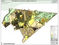
The <strong>Township</strong> <strong>Highlands</strong> Area includes the <strong>Highlands</strong> Zones and Sub-Zones listed and<br />
described below. These Zones are configured as depicted in Exhibit A (“<strong>Township</strong> <strong>Highlands</strong><br />
Area”) and are herewith incorporated into the Land Use Plan as an overlay to the existing<br />
Land Use Plan. The <strong>Highlands</strong> Council delineation <strong>of</strong> <strong>Highlands</strong> Zones finds basis in the<br />
underlying natural resources, the extent <strong>of</strong> existing development and supporting<br />
infrastructure, and the potential to support new development and/or redevelopment.<br />
<strong>Highlands</strong> Zones are intended to ensure that the density and intensity <strong>of</strong> future<br />
development and/or redevelopment do not exceed the capacity <strong>of</strong> the land, natural<br />
resources, and existing infrastructure to support it.<br />
The <strong>Highlands</strong> Zones in <strong>Rockaway</strong> <strong>Township</strong> include two primary zones (the Protection<br />
Zone and Existing Community Zone) and three sub-zones (Wildlife Management Sub-Zone,<br />
Existing Community Zone–Environmentally Constrained Sub-Zone, and Lake Community<br />
Sub-Zone) each with its own purpose, application and development criteria.<br />
1. Protection Zone. The Protection Zone consists <strong>of</strong> the highest quality natural<br />
resource value lands that are essential to maintaining water quality, water quantity<br />
and sensitive ecological resources and processes. Land acquisition is a high priority<br />
<strong>for</strong> lands in the Protection Zone and development activities will be extremely<br />
limited. Any development will be subject to stringent limitations on consumptive<br />
and depletive water use, degradation <strong>of</strong> water quality, and impacts to<br />
environmentally sensitive lands and natural resources.<br />
a. Wildlife Management Sub-Zone. The Wildlife Management Sub-Zone consists<br />
<strong>of</strong> areas managed by the United States Fish and Wildlife Service as part <strong>of</strong> the<br />
National Wildlife Refuge System, and lands within the Wildlife Management<br />
Area System administered by the NJDEP Division <strong>of</strong> Fish & Wildlife’s Bureau <strong>of</strong><br />
Land Management. These areas are part <strong>of</strong> a network <strong>of</strong> lands and waters <strong>for</strong><br />
conservation, management, and where appropriate, restoration <strong>of</strong> fish, wildlife<br />
and plant resources and their habitats and permit compatible wildlifedependent<br />
recreational uses.<br />
2. Existing Community Zone. The Existing Community Zone consists <strong>of</strong> areas <strong>of</strong><br />
concentrated development representing existing communities. These areas tend to<br />
have limited environmental constraints due to previous development patterns, and<br />
may have existing infrastructure that can support additional development and/or<br />
redevelopment. Where served by adequate supporting infrastructure, lands within<br />
the Existing Community Zone are suited to higher densities and intensities <strong>of</strong><br />
development (see Section C, below) than other Zones. This Zone has the greatest<br />
potential to accommodate mixed-use development projects and center-based<br />
planning initiatives, generally.<br />
- 10 -
<strong>DRAFT</strong> <strong>Highlands</strong> <strong>Element</strong> to the <strong>Rockaway</strong> <strong>Township</strong> Master Plan November 2010<br />
a. Existing Community Zone–Environmentally Constrained Sub-Zone. The<br />
Existing Community Zone–Environmentally Constrained Sub-Zone consists <strong>of</strong><br />
significant contiguous critical habitat, steep slopes and <strong>for</strong>ested lands within the<br />
Existing Community Zone that should be protected from further fragmentation.<br />
They serve as regional habitat “stepping stones” to larger contiguous critical<br />
habitat and <strong>for</strong>ested areas. As such, they are not appropriate <strong>for</strong> significant<br />
development, and are best served by land preservation and protection.<br />
Development is subject to stringent limitations on consumptive and depletive<br />
water use, degradation <strong>of</strong> water quality, and impacts to environmentally<br />
sensitive lands.<br />
b. Lake Community Sub-Zone. The Lake Community Sub-Zone consists <strong>of</strong><br />
patterns <strong>of</strong> community development that are within the Existing Community<br />
Zone within 1,000 feet <strong>of</strong> lakes. Lakes are defined to include those 10 acres or<br />
greater in size with lake management areas consisting <strong>of</strong> lands within the first<br />
1,000 feet (or less, depending on the protection focus) from the lake shoreline.<br />
The purpose <strong>for</strong> the sub-zone is to protect and enhance water quality, resource<br />
features, shoreline recreation, scenic quality, and community character. This<br />
zone incorporates unique regulatory requirements to prevent degradation <strong>of</strong><br />
water quality, harm to lake ecosystems, and watershed pollution, while<br />
promoting natural aesthetic values within the Existing Community Zone.<br />
In light <strong>of</strong> the significant environmental constraints that affect many <strong>of</strong> the <strong>Highlands</strong> Zones<br />
and Sub-Zones, future growth should be channeled into compact centers within them,<br />
where feasible, provided suitable locations can be identified. Such development must<br />
incorporate smart growth principles and should be designed at densities (see Section C,<br />
below) appropriate to the Zone, the community character, and the capacities <strong>of</strong> the water<br />
and wastewater systems (including septic systems) that support them. The Planning Board<br />
will examine the potential <strong>for</strong> such opportunities.<br />
B. LAND USES<br />
The intents and purposes <strong>for</strong> each municipal land use category or zoning district, as set<br />
<strong>for</strong>th by the underlying Land Use Plan, are herewith amended to recognize and give priority<br />
to the intents and purposes listed above <strong>for</strong> the <strong>Highlands</strong> Zones and Sub-Zones. As to land<br />
use classifications (e.g., single- or multi-family residential, commercial, industrial) and<br />
specific permitted land uses, a thorough review and comparison between municipal and<br />
<strong>Highlands</strong> Zones and Sub-Zones must be undertaken to assess compatibility and to<br />
determine whether zoning amendments (pertinent to non-exempt development) are<br />
necessary to achieve consistency. Until such time as that examination is complete,<br />
permitted uses shall remain in effect <strong>for</strong> non-exempt development, with the significant<br />
caveat that each is subject to compliance with: a) all resource constraints (discussed at<br />
length in the Conservation Plan <strong>Element</strong>); b) all applicable provisions <strong>of</strong> both the NJDEP<br />
<strong>Highlands</strong> Water Protection and Planning Act Rules (N.J.A.C. 7:38) and the New Jersey<br />
- 11 -
<strong>DRAFT</strong> <strong>Highlands</strong> <strong>Element</strong> to the <strong>Rockaway</strong> <strong>Township</strong> Master Plan November 2010<br />
Department <strong>of</strong> Agriculture (NJDA) Agricultural Development in the <strong>Highlands</strong> Rules (N.J.A.C.<br />
2:92); and c) the density and intensity requirements set <strong>for</strong>th in the section that follows<br />
(see Section C, Density and Intensity <strong>of</strong> Development).<br />
Specific immediate changes to permitted uses will include the following, each pending the<br />
adoption <strong>of</strong> implementing ordinance provisions approved by the <strong>Highlands</strong> Council:<br />
1. Carbonate Rock Area. Upon adoption <strong>of</strong> the appropriate regulatory provisions, the<br />
following principal and/or accessory uses and/or structures, where otherwise<br />
permitted by the municipal ordinance, shall be explicitly prohibited from any<br />
portion <strong>of</strong> the <strong>Highlands</strong> Area designated a “Carbonate Rock Area” (as defined and<br />
delineated in the Conservation Plan <strong>Element</strong>) or from any lands identified as<br />
draining into a designated Carbonate Rock Area: solid waste landfills, hazardous<br />
waste storage and disposal facilities, hazardous materials storage and handling<br />
facilities, and underground storage tanks.<br />
2. Prime Ground Water Recharge Area. Upon adoption <strong>of</strong> the appropriate regulatory<br />
provisions, any principal and/or accessory use or structure related or devoted to<br />
such use, which is designated as a Major Potential Contaminant Source (PCS) by the<br />
<strong>Highlands</strong> Council (see Appendices A and C), where otherwise permitted by the<br />
municipal ordinance, shall be expressly prohibited from any portion <strong>of</strong> the<br />
<strong>Highlands</strong> Area delineated as a “Prime Ground Water Recharge Area” (as defined<br />
and delineated in the Conservation Plan <strong>Element</strong>).<br />
3. Wellhead Protection Area (Tier 1). Upon adoption <strong>of</strong> the appropriate regulatory<br />
provisions, any principal and/or accessory use or structure related or devoted to<br />
such use, which is listed as a Major or Minor Potential Contaminant Source (PCS) or<br />
which is designated by the <strong>Highlands</strong> Council as a potential source <strong>of</strong> pathogenic<br />
contaminants (see Appendices A, B and C), where otherwise permitted by the<br />
municipal ordinance, shall be expressly prohibited from any portion <strong>of</strong> the<br />
<strong>Highlands</strong> Area delineated as a “Tier 1 Wellhead Protection Area” (as defined and<br />
delineated in the Conservation Plan <strong>Element</strong>).<br />
4. Wellhead Protection Area (Tier 2). Upon adoption <strong>of</strong> the appropriate regulatory<br />
provisions, any principal and/or accessory use or structure related or devoted to<br />
such use, which is designated as a Major Potential Contaminant Source (PCS) by the<br />
<strong>Highlands</strong> Council (see Appendices A and C) where otherwise permitted by the<br />
municipal ordinance, shall be expressly prohibited from any portion <strong>of</strong> the<br />
<strong>Highlands</strong> Area delineated as a “Tier 2 Wellhead Protection Area” (as defined and<br />
delineated in the Conservation Plan <strong>Element</strong>).<br />
5. <strong>Highlands</strong> Special Environmental Zone. Upon adoption <strong>of</strong> the appropriate<br />
regulatory provisions, the permitted principal and accessory uses (and any<br />
structures related or devoted to such uses) applicable to any land falling within a<br />
designated “<strong>Highlands</strong> Special Environmental Zone” (as defined and delineated in<br />
- 12 -
<strong>DRAFT</strong> <strong>Highlands</strong> <strong>Element</strong> to the <strong>Rockaway</strong> <strong>Township</strong> Master Plan November 2010<br />
the Land Preservation & Land Stewardship Plan <strong>Element</strong>), shall be modified such<br />
that they remain valid only in conjunction with a waiver permitting such use from<br />
the <strong>Highlands</strong> Council.<br />
C. DENSITY AND INTENSITY OF DEVELOPMENT<br />
The physical potential <strong>for</strong> development and/or redevelopment in each <strong>Highlands</strong> Zone and<br />
Sub-Zone <strong>of</strong> the <strong>Township</strong> <strong>Highlands</strong> Area is limited by existing natural features, resource<br />
protection priorities, and the capacity <strong>of</strong> the land and available infrastructure to support it.<br />
This section sets <strong>for</strong>th a capacity-based planning framework intended to ensure that future<br />
development and redevelopment do not exceed carrying capacity.<br />
To the extent that the existing development density and intensity standards <strong>of</strong> the<br />
underlying zone districts (as defined and applied under the existing Land Use Plan and<br />
Zoning Ordinance) are consistent with the parameters <strong>of</strong> this section, they shall remain in<br />
effect. Where any density or intensity goals <strong>of</strong> the existing Land Use Plan are inconsistent<br />
with these limits, they are herewith modified with respect to the <strong>Highlands</strong> Area, to the<br />
extent necessary to con<strong>for</strong>m to the <strong>Highlands</strong> RMP. For purposes <strong>of</strong> these provisions,<br />
density <strong>of</strong> development standards refer to the requirements <strong>of</strong> the underlying Zoning<br />
Ordinance that regulate the permitted number <strong>of</strong> dwelling units per acre <strong>of</strong> land, whether<br />
specifically defined as density standards or set <strong>for</strong>th as minimum lot size requirements <strong>for</strong><br />
application to specific zoning districts. Intensity <strong>of</strong> development standards refer to those<br />
requirements used to define the relationship between the permitted extent, <strong>for</strong>m and<br />
location <strong>of</strong> development <strong>of</strong> a lot, to the size, shape, and configuration <strong>of</strong> the lot on which it is<br />
situated (e.g., floor area ratio, building coverage, building height, yard setbacks, number <strong>of</strong><br />
stories).<br />
In the context herein, modifications to the underlying density or intensity <strong>of</strong> development<br />
standards will occur only to the extent that existing standards conflict with provisions <strong>of</strong> the<br />
<strong>Highlands</strong> Act, NJDEP Preservation Area Rules, or RMP, in particular those concerning water<br />
availability or available septic system yield. These modifications shall not apply to lawfully<br />
existing or approved development in the <strong>Highlands</strong> Area at the time <strong>of</strong> adoption <strong>of</strong> the<br />
ordinances that effectuate such provisions. They shall apply, however, if modifications or<br />
improvements to such existing development result in an increase in demand <strong>for</strong> water<br />
availability or septic system yield (excluding any increase directly attributed to exercise <strong>of</strong> a<br />
<strong>Highlands</strong> Act exemption).<br />
Permitted densities and intensities <strong>of</strong> development shall comport with the provisions <strong>of</strong> the<br />
<strong>Highlands</strong> RMP, <strong>Highlands</strong> Council Technical Reports and all data related thereto, and the<br />
applicable provisions <strong>of</strong> the Preservation Area Rules adopted by the NJDEP (N.J.A.C. 7:38).<br />
As provided therein, the framework <strong>for</strong> setting development density/intensity guidelines<br />
relies primarily on water and wastewater capacity analyses, with natural resource<br />
constraints to be applied largely on a project-specific basis at the development review level.<br />
Permitted density and intensity allowances <strong>for</strong> the <strong>Highlands</strong> Area must also reflect<br />
municipal intents with respect to growth and development <strong>of</strong> the community. A<br />
- 13 -
<strong>DRAFT</strong> <strong>Highlands</strong> <strong>Element</strong> to the <strong>Rockaway</strong> <strong>Township</strong> Master Plan November 2010<br />
comprehensive analysis will be required as follow-up to adoption <strong>of</strong> the <strong>Highlands</strong> <strong>Element</strong>,<br />
to determine specific density and intensity allowances <strong>for</strong> future non-exempt development<br />
within the <strong>Highlands</strong> Area. The Board will, with the assistance <strong>of</strong> its pr<strong>of</strong>essionals, complete<br />
this analysis to determine: 1) the capacity <strong>for</strong> future growth and development <strong>of</strong> the<br />
<strong>Highlands</strong> Area (based on the RMP, Technical Reports, NJDEP Rules); 2) the extent to which<br />
such growth may be appropriate within the relevant portions <strong>of</strong> the community; and 3) the<br />
specific allocation <strong>of</strong> such growth and development over the <strong>Highlands</strong> Zones and Sub-<br />
Zones. (This analysis will take place with assistance from the <strong>Highlands</strong> Council after the<br />
<strong>Township</strong> has achieved Basic Plan Con<strong>for</strong>mance.)<br />
Until such time as the full analysis can be completed, applications <strong>for</strong> development within<br />
the <strong>Highlands</strong> Area require reviews <strong>for</strong> consistency on a project-by-project basis. The major<br />
criteria <strong>for</strong> assessing the proposed density/intensity <strong>of</strong> development include the following:<br />
1. Base Maps/Data. Base data regarding water availability and wastewater treatment<br />
capacity appear in the technical in<strong>for</strong>mation provided in the Conservation Plan and<br />
Utility Services Plan <strong>Element</strong>s, which includes associated mapping identified as<br />
Exhibits Q, U, and V. These include, respectively, the <strong>Township</strong> <strong>Highlands</strong> Area: Net<br />
Water Availability Map, Public Community Water Systems Map, and <strong>Highlands</strong><br />
Domestic Sewerage Facilities Map. All are herewith adopted and incorporated as a<br />
component <strong>of</strong> the <strong>Highlands</strong> <strong>Element</strong>.<br />
2. Water Availability. As provided under Conservation Plan <strong>Element</strong> Section G,<br />
Water Resources Availability.<br />
3. Public Water Supply and Wastewater Utilities. Where properties are served by<br />
existing water and wastewater utility infrastructure having sufficient available<br />
capacity, the density and intensity <strong>of</strong> new development shall be consistent with the<br />
requirements <strong>of</strong> existing zoning.<br />
4. Public Water Supply Utilities – Key Provisions<br />
a. Preservation Area. New, expanded, or extended public water systems are<br />
prohibited unless approved through issuance <strong>of</strong> either a <strong>Highlands</strong> Applicability<br />
Determination indicating that a project is exempt from the <strong>Highlands</strong> Act, or a<br />
<strong>Highlands</strong> Preservation Area Approval with waiver pursuant to N.J.A.C. 7:38.<br />
b. Planning Area – Protection Zone and Environmentally-Constrained Sub-<br />
Zones. New, expanded, or extended public water systems are permitted only<br />
where approved by the <strong>Highlands</strong> Council.<br />
c. Planning Area – Existing Community Zone (excluding Environmentally-<br />
Constrained Sub-Zone, including Lake Community Sub-Zone). Expansion or<br />
creation <strong>of</strong> public water systems is permitted: to serve lands which are<br />
appropriate <strong>for</strong> Transfer <strong>of</strong> Development Rights (TDR) Receiving Zones, infill<br />
development, or redevelopment; to address public health and safety; or to serve<br />
new areas <strong>for</strong> development that address all other requirements <strong>of</strong> the RMP.<br />
- 14 -
<strong>DRAFT</strong> <strong>Highlands</strong> <strong>Element</strong> to the <strong>Rockaway</strong> <strong>Township</strong> Master Plan November 2010<br />
5. Wastewater Utilities – Key Provisions<br />
a. Preservation Area. New, expanded or extended wastewater collection and<br />
treatment systems and community on-site treatment facilities are prohibited<br />
unless approved through issuance <strong>of</strong> either a <strong>Highlands</strong> Applicability<br />
Determination indicating that a project is exempt from the <strong>Highlands</strong> Act, or a<br />
<strong>Highlands</strong> Preservation Area Approval with waiver pursuant to N.J.A.C. 7:38.<br />
b. Planning Area – Protection Zone and Environmentally-Constrained Sub-<br />
Zones. New, expanded or extended wastewater collection and treatment<br />
systems and community on-site treatment facilities are permitted only where<br />
approved by the <strong>Highlands</strong> Council.<br />
c. Planning Area – Existing Community Zone (excluding Environmentally-<br />
Constrained Sub-Zone, but including Lake Community Sub-Zone). Expansion or<br />
creation <strong>of</strong> wastewater collection and treatment systems and community on-site<br />
treatment facilities are permitted: to serve lands which are appropriate <strong>for</strong><br />
designated TDR Receiving Zones, infill development, or redevelopment; to<br />
address public health and safety; or to serve new areas <strong>for</strong> development that<br />
address all other requirements <strong>of</strong> the RMP. Such systems and facilities will be<br />
subject to all conditions <strong>of</strong> approval associated with amended Areawide Water<br />
Quality Management Plans, as authorized by the NJDEP in coordination with the<br />
<strong>Highlands</strong> Council.<br />
6. Septic Systems – Key Provisions<br />
a. Major <strong>Highlands</strong> Development, Preservation Area. Development proposals<br />
involving the installation <strong>of</strong> one or more new individual subsurface disposal<br />
systems (or aggregate <strong>of</strong> equivalent disposal units as provided at N.J.A.C. 7:38)<br />
shall meet NJDEP septic system density requirements as set <strong>for</strong>th at N.J.A.C.<br />
7:38. In the case <strong>of</strong> Cluster Development, the septic system density <strong>for</strong> the<br />
developed portion <strong>of</strong> the site shall be based on a nitrate dilution target not to<br />
exceed 10 mg/L, determined by application <strong>of</strong> the modified Trela-Douglas<br />
Nitrate Dilution Model, as provided below.<br />
b. Non-Major <strong>Highlands</strong> Development, Preservation Area and all<br />
Development, Planning Area.<br />
i. Nitrate Targets. The following nitrate dilution targets shall apply to<br />
the calculation <strong>of</strong> septic system yields:<br />
Existing Community Zone (and Sub-Zones) – 2 mg/L,<br />
maximum<br />
Protection Zone (and Sub-Zones) – 0.72 mg/L, maximum<br />
ii. Cluster Development Nitrate Targets. New residential cluster<br />
development (see Section D) shall have a gross septic system density<br />
- 15 -
<strong>DRAFT</strong> <strong>Highlands</strong> <strong>Element</strong> to the <strong>Rockaway</strong> <strong>Township</strong> Master Plan November 2010<br />
(<strong>for</strong> all parcels involved in the development proposal) based on the<br />
nitrate dilution target applicable to the <strong>Highlands</strong> Zone (6b.i, above).<br />
The septic system density <strong>for</strong> the developed portion <strong>of</strong> the site,<br />
however, shall be based on a nitrate dilution target not to exceed 10<br />
mg/L.<br />
iii. Septic System Density/Yield. Septic system densities will vary not<br />
only on the basis <strong>of</strong> nitrate targets <strong>for</strong> each Zone (as above), but by<br />
HUC14 subwatershed, on the basis <strong>of</strong> drought ground water<br />
recharge. Septic system yields will further vary based on the amount<br />
<strong>of</strong> undeveloped and underdeveloped lands where septic system<br />
densities can be applied.<br />
iv. Nitrate Dilution Model. Development proposals involving any need<br />
<strong>for</strong> new or increased septic system capacity shall demonstrate<br />
compliance with the nitrate targets in 6b.i and, where applicable,<br />
6b.ii above. Such compliance shall be determined by application <strong>of</strong><br />
one <strong>of</strong> the following methods:<br />
The modified Trela-Douglas nitrate dilution model used by the<br />
NJDEP (<strong>for</strong> more in<strong>for</strong>mation see<br />
http://www.highlands.state.nj.us/njhighlands/plancon<strong>for</strong>mance<br />
), but with recharge based on drought conditions. This model<br />
provides the minimum acreage required per septic system, to<br />
ensure that recharge is sufficient to achieve a specified nitrate<br />
dilution target. The following factors, representative <strong>of</strong> a onefamily<br />
household, or wastewater generation <strong>of</strong> 300 gallons per<br />
day, shall be used as inputs to the model: a household size <strong>of</strong> 4<br />
persons, average nitrate loading <strong>of</strong> 10 pounds per person per<br />
year, and drought ground water recharge <strong>for</strong> the HUC14<br />
subwatershed as dilution.<br />
The chart <strong>of</strong> minimum average lot sizes by HUC14 subwatershed<br />
and <strong>Highlands</strong> Zone (including sub-zones) provided by the<br />
<strong>Highlands</strong> Council indicating the minimum average land area<br />
necessary <strong>for</strong> each new septic system (or equivalent system yield<br />
based on an average 300 gallons per day <strong>of</strong> wastewater<br />
generation). A copy <strong>of</strong> the chart is available at:<br />
http://www.highlands.state.nj.us/njhighlands/plancon<strong>for</strong>mance<br />
/.<br />
v. Application <strong>of</strong> Results. The septic system yield <strong>for</strong> a proposed<br />
project shall be determined by dividing the total project area by the<br />
minimum acreage required per septic system, as determined by one<br />
<strong>of</strong> these models. For non-residential development, the resulting<br />
acreage is that necessary to support every 300 gallons <strong>of</strong> daily<br />
- 16 -
<strong>DRAFT</strong> <strong>Highlands</strong> <strong>Element</strong> to the <strong>Rockaway</strong> <strong>Township</strong> Master Plan November 2010<br />
wastewater flow generated by the proposed non-residential use (see<br />
conversion factors below). Where a project site is located within<br />
more than one HUC14 subwatershed, septic system yields shall be<br />
computed <strong>for</strong> and applied to each portion <strong>of</strong> the site, accordingly.<br />
This approach shall be applied on a project-specific basis until such<br />
time as the Septic System Yield is allocated among parcels through<br />
municipal zoning; the allocation <strong>of</strong> yield shall supersede this method.<br />
Regardless <strong>of</strong> whether a project-specific yield analysis or an<br />
allocation <strong>of</strong> Septic System Yield by zoning applies, the<br />
subwatershed yield shall in no case be exceeded; an increase in any<br />
one portion <strong>of</strong> a HUC14 subwatershed must be <strong>of</strong>fset by an<br />
equivalent decrease elsewhere within the same subwatershed.<br />
For purposes <strong>of</strong> these analyses, the RMP septic system yield<br />
rules apply (see the <strong>Highlands</strong> Council Regional Build-Out<br />
Technical Report). For residential uses, the calculation<br />
assumes wastewater generation <strong>of</strong> 300 gallons per<br />
household per day. The RMP equivalent dwelling unit (EDU)<br />
value <strong>for</strong> non-residential septic uses equates to 2,400 square<br />
feet <strong>of</strong> Office/Commercial space and 18,182 square feet <strong>of</strong><br />
Industrial space.<br />
For detached single-family residential development, where<br />
the underlying density allowances <strong>of</strong> the Master Plan and<br />
zoning regulations are higher than those resulting from the<br />
nitrate dilution analysis as provided herein, septic system<br />
yields and resultant system density (typically denoted as<br />
minimum average acreage per septic system) may be<br />
equated to maximum permitted dwelling unit yield and<br />
minimum average lot size. Alternatively, the underlying<br />
allowances may be applied over a portion <strong>of</strong> the project area,<br />
to the point at which the calculated septic system yield (by<br />
HUC14) is reached, with the remainder <strong>of</strong> the site left<br />
undeveloped. If a <strong>Highlands</strong> Council-approved Cluster<br />
Development Ordinance (see Section D, following) has been<br />
adopted, its provisions shall apply and may take precedence<br />
in making this determination, if so provided therein.<br />
For all other <strong>for</strong>ms <strong>of</strong> development, projects shall be<br />
evaluated on the basis <strong>of</strong> overall wastewater disposal need<br />
and the capacity <strong>of</strong> the calculated septic system yield to<br />
support it.<br />
D. CLUSTER DEVELOPMENT<br />
- 17 -
<strong>DRAFT</strong> <strong>Highlands</strong> <strong>Element</strong> to the <strong>Rockaway</strong> <strong>Township</strong> Master Plan November 2010<br />
In furtherance <strong>of</strong> the goals and objectives <strong>of</strong> the <strong>Highlands</strong> <strong>Element</strong>, and <strong>of</strong> the State<br />
Development and Redevelopment Plan (SDRP), this Land Use Plan embraces cluster and<br />
conservation design development. These concepts allow flexibility in the design and lay-out<br />
<strong>of</strong> development projects, providing opportunity <strong>for</strong> new construction while addressing<br />
other priorities, such as: protecting environmentally sensitive areas, preserving large<br />
contiguous areas <strong>of</strong> open space and agricultural land, and enabling the continuation <strong>of</strong><br />
existing agricultural and/or horticultural land uses.<br />
Specifically, this Plan continues the <strong>Township</strong>’s ongoing policy <strong>of</strong> permitting optional<br />
cluster development in the Very Low Density (R-5 Acre and R-88 Zones only), Low Density,<br />
and Moderate Density Residential land use categories, wherein residential development<br />
may be concentrated on a limited portion <strong>of</strong> a much larger tract, with the remaining land<br />
permanently deed-restricted <strong>for</strong> agriculture, conservation or open space and either held in<br />
common by the homeowners or dedicated to the municipality. Residential cluster<br />
development shall be permitted within the areas set <strong>for</strong>th above wherever the minimum<br />
thresholds <strong>for</strong> residential cluster development pursuant to Sections 54-30.13, 54-30.21.f.,<br />
54-30.22.f., 54-30.23.f., and 54-30.29.f. <strong>of</strong> the <strong>Township</strong>’s Land Use Ordinance can be<br />
satisfied.<br />
E. LAND USE INVENTORY<br />
Planning <strong>for</strong> the future <strong>of</strong> the <strong>Highlands</strong> Area requires a clear understanding and<br />
assessment <strong>of</strong> existing land uses and development within the <strong>Highlands</strong> Area, in the areas<br />
surrounding the <strong>Highlands</strong> Area, and throughout the municipality. The <strong>Township</strong> Land Use<br />
Inventory prepared by Robert Catlin and Associates, is representative <strong>of</strong> land use and<br />
development conditions within the municipality through April, 1990 (see Exhibit B). The<br />
Land Use Inventory requires an update to accurately represent existing land uses.<br />
F. REDEVELOPMENT PLANNING<br />
The Planning Board will examine the potential <strong>for</strong> redevelopment opportunities within the<br />
<strong>Highlands</strong> Area. The term “redevelopment” is used herein to refer to reconstruction or reuse<br />
<strong>of</strong> previously developed and underutilized properties (which may include Preservation<br />
Area sites that have 70% or greater <strong>of</strong> impervious surface, as well as other redevelopment<br />
and “grayfield” sites in the Planning Area), and to the rehabilitation and re-use <strong>of</strong><br />
“brownfield” sites (identified as such by NJDEP where in the Preservation Area). Unless<br />
specifically stated otherwise, neither the term “redevelopment,” nor the phrase “in need <strong>of</strong><br />
redevelopment” is used herein to invoke the definitions, processes, powers or any other<br />
facet <strong>of</strong> the provisions <strong>of</strong> the New Jersey Local Redevelopment and Housing Law (N.J.S.A.<br />
40A:12A-1 et seq.).<br />
Rather, <strong>Highlands</strong> Area redevelopment planning refers to the identification <strong>of</strong> previously<br />
developed areas that: a) are suitable <strong>for</strong> re-use and/or reconstruction, or reversion to<br />
- 18 -
<strong>DRAFT</strong> <strong>Highlands</strong> <strong>Element</strong> to the <strong>Rockaway</strong> <strong>Township</strong> Master Plan November 2010<br />
“greenfields,” such as parklands, conservation areas, or open space; and/or b) may be<br />
eligible <strong>for</strong> designation by the <strong>Highlands</strong> Council as <strong>Highlands</strong> Redevelopment Areas.<br />
<strong>Highlands</strong> Redevelopment Areas are typically characterized by ready access to or potential<br />
<strong>for</strong> water and wastewater utility infrastructure (and available or potential capacities);<br />
existing transportation infrastructure and/or services with links to viable transportation<br />
networks; proximity to supporting community facilities and services; and suitability <strong>for</strong><br />
increased development intensity in keeping with smart growth planning principles. Where<br />
brownfields are involved in the Preservation Area, NJDEP identification <strong>of</strong> the brownfield<br />
site is a necessary step prior to <strong>Highlands</strong> Council designation <strong>of</strong> a <strong>Highlands</strong><br />
Redevelopment Area. In the Preservation Area, such applications must be submitted to<br />
NJDEP <strong>for</strong> a <strong>Highlands</strong> Preservation Area Approval (HPAA) with Redevelopment Waiver.<br />
It is the intent <strong>of</strong> this Plan to encourage redevelopment where appropriate within the<br />
<strong>Highlands</strong> Area, to ensure optimal and efficient use <strong>of</strong> land. By maximizing the use <strong>of</strong><br />
previously developed areas and areas in need <strong>of</strong> environmental clean-up or other<br />
improvements, the municipality may provide <strong>for</strong> desirable new development (or new green<br />
spaces), while protecting lands that contain sensitive environmental features and important<br />
<strong>Highlands</strong> resources. This approach is intended to guide development toward the most<br />
suitable locations in the municipality, to encourage environmental clean-up where needed,<br />
and to maximize the use <strong>of</strong> existing infrastructure to meet future needs.<br />
Redevelopment projects and activities that con<strong>for</strong>m to density/intensity allowances and<br />
meet all other requirements <strong>of</strong> the applicable land use ordinances (specifically including<br />
those developed <strong>for</strong> the <strong>Highlands</strong> Area and the <strong>Highlands</strong> Preservation Area Rules at<br />
N.J.A.C. 7:38), do not require <strong>Highlands</strong> Redevelopment Area designation and may proceed<br />
as <strong>of</strong> right in accordance with all municipal procedural requirements. Any municipallysponsored<br />
redevelopment project proposed pursuant to N.J.S.A. 40A:12A, while perhaps<br />
also requiring <strong>Highlands</strong> Council Redevelopment Area designation, must be advanced in<br />
accordance with all applicable statutory requirements, including preparation and adoption<br />
by the Governing Body <strong>of</strong> a Redevelopment Plan. The Planning Board, in making any<br />
<strong>Highlands</strong> Area determination <strong>of</strong> “area in need <strong>of</strong> redevelopment” pursuant to N.J.S.A.<br />
40A:12A, will incorporate the considerations listed below <strong>for</strong> <strong>Highlands</strong> Redevelopment<br />
Area designations in evaluating the applicable criteria under N.J.S.A. 40A:12A-5.<br />
1. Definitions.<br />
a. A “brownfield” site consists <strong>of</strong> a commercial or industrial site that is currently<br />
vacant or underutilized and on which there has been or is suspected to have<br />
been, a contaminant discharge.<br />
b. A “grayfield” site consists <strong>of</strong> a site supported by existing infrastructure that<br />
contains an industrial or commercial facility (not excluding one having a<br />
residential component) exhibiting signs <strong>of</strong> abandonment or underutilization, but<br />
without evidence or expectation <strong>of</strong> contamination.<br />
- 19 -
<strong>DRAFT</strong> <strong>Highlands</strong> <strong>Element</strong> to the <strong>Rockaway</strong> <strong>Township</strong> Master Plan November 2010<br />
c. A “redevelopment project” or “redevelopment activity” refers to the re-use,<br />
reconstruction, or conversion to alternate use, <strong>of</strong> a brownfield site, a grayfield<br />
site, or a previously developed site that is currently vacant or underutilized in<br />
the <strong>Highlands</strong> Area. Redevelopment projects and activities may include but are<br />
not limited to: removal, reconstruction, or adaptive reuse <strong>of</strong> existing buildings<br />
and other structures; construction <strong>of</strong> new buildings and other structures; and<br />
conversion/restoration <strong>of</strong> a site or portions <strong>of</strong> a site <strong>for</strong> open space, recreation<br />
or conservation purposes <strong>of</strong> any kind.<br />
d. A “<strong>Highlands</strong> Redevelopment Area” consists <strong>of</strong> a property or group <strong>of</strong> properties<br />
designated as such by the <strong>Highlands</strong> Council, and which includes one or more <strong>of</strong><br />
the following: a) a brownfield site; b) a grayfield site; and c) any previously<br />
developed site in the <strong>Highlands</strong> Area. A <strong>Highlands</strong> Redevelopment Area may<br />
include the intervening or surrounding lands which are significantly affected by<br />
or are necessary to support such sites, and will be subject to a <strong>Highlands</strong><br />
Council-approved redevelopment plan setting <strong>for</strong>th the full scope and details <strong>of</strong><br />
the proposed redevelopment project(s) and/or activities.<br />
2. Redevelopment Projects and Activities.<br />
a. Redevelopment projects and activities that comply with all applicable land use<br />
ordinances (specifically including those developed <strong>for</strong> the <strong>Highlands</strong> Area) are<br />
encouraged in all Areas, Zones, and Subzones <strong>of</strong> the <strong>Highlands</strong> Area. Such<br />
projects and activities are also subject to all applicable county, state, and federal<br />
regulatory requirements.<br />
b. Redevelopment projects and activities involving conversion to greenfields are<br />
particularly encouraged in environmentally constrained areas, where<br />
compliance with <strong>Highlands</strong> Area ordinance provisions <strong>for</strong> new development<br />
may not be feasible.<br />
c. In consideration <strong>of</strong> the <strong>for</strong>egoing, the Board will recommend specific sites,<br />
consisting <strong>of</strong> brownfields, grayfields, and/or other previously developed vacant<br />
or underutilized properties, that should be considered <strong>for</strong> potential<br />
redevelopment projects and/or activities in accordance with all applicable<br />
ordinances and regulatory requirements.<br />
3. <strong>Highlands</strong> Redevelopment Areas. In assessing the potential <strong>for</strong> <strong>Highlands</strong><br />
Redevelopment Area designations, the Planning Board incorporates the following<br />
relevant considerations:<br />
a. <strong>Highlands</strong> Redevelopment Area designation in the Preservation Area is confined<br />
to: a) sites having 70% or greater impervious coverage, and/or b) sites<br />
designated as “<strong>Highlands</strong> brownfields” in accordance with NJDEP Preservation<br />
Area Rules (at N.J.A.C. 7:38-6.6). In addition to <strong>Highlands</strong> Council approval, a<br />
- 20 -
<strong>DRAFT</strong> <strong>Highlands</strong> <strong>Element</strong> to the <strong>Rockaway</strong> <strong>Township</strong> Master Plan November 2010<br />
waiver is required from the NJDEP in conjunction with a <strong>Highlands</strong> Preservation<br />
Area Approval (HPAA).<br />
b. <strong>Highlands</strong> Redevelopment Area designation within the Planning Area will<br />
require <strong>Highlands</strong> Council approval <strong>of</strong> a detailed redevelopment plan. This plan<br />
will supersede all ordinances otherwise applicable to the <strong>Highlands</strong><br />
Redevelopment Area, including those developed specifically <strong>for</strong> the <strong>Township</strong><br />
<strong>Highlands</strong> Area, and will fully regulate the use and development <strong>of</strong> lands within<br />
the <strong>Highlands</strong> Redevelopment Area.<br />
c. <strong>Highlands</strong> Redevelopment Area designation will only be considered where lands<br />
are particularly suited to the proposed redevelopment plan, by virtue <strong>of</strong> a<br />
preponderance <strong>of</strong> existing characteristics such as, but not limited to:<br />
appropriate community location; availability <strong>of</strong> water and wastewater utility<br />
infrastructure and capacity; access to transit and/or other suitable<br />
transportation systems and networks; suitability <strong>for</strong> increased land use<br />
intensity or conversion to greenfields, as applicable; extensive coverage by<br />
impervious surfaces; proximity to community facilities and services; potential to<br />
embody and/or further smart growth principles; opportunity to protect<br />
resources; and potential to contribute to a sustainable local and/or regional<br />
economy.<br />
d. Any redevelopment project or activity permitted under the auspices <strong>of</strong><br />
<strong>Highlands</strong> Redevelopment Area redevelopment plan must be designed and<br />
developed in accordance with smart growth and Low Impact Development<br />
principles (see Section K).<br />
e. Identification <strong>of</strong> opportunities <strong>for</strong> redevelopment projects and activities that are<br />
potentially suitable <strong>for</strong> <strong>Highlands</strong> Redevelopment Area designation in the<br />
<strong>Highlands</strong> Area should be assisted by the <strong>Highlands</strong> Council Redevelopment and<br />
Infill Analysis Tool. This review should also include any sites depicted in Exhibit<br />
C, “<strong>Highlands</strong> Contaminated Sites Inventory”. In<strong>for</strong>mation on <strong>Highlands</strong><br />
Contaminated Site Inventories is available in the <strong>Highlands</strong> Council Regional<br />
Land Use Conditions and Smart Design Guidelines Technical Report.<br />
f. In consideration <strong>of</strong> the <strong>for</strong>egoing, the Planning Board will identify potential<br />
<strong>Highlands</strong> Redevelopment Areas.<br />
- 21 -
<strong>DRAFT</strong> <strong>Highlands</strong> <strong>Element</strong> to the <strong>Rockaway</strong> <strong>Township</strong> Master Plan November 2010<br />
HOUSING PLAN<br />
<strong>Rockaway</strong> <strong>Township</strong>’s Planning Board adopted a Third Round Housing <strong>Element</strong> and Fair<br />
Share Plan, prepared by Burgis Associates, Inc., on June 1, 2010. The adopted Housing<br />
<strong>Element</strong> incorporates all applicable goals and objectives relating to the <strong>Highlands</strong> Area,<br />
consistent with the <strong>Highlands</strong> Regional Master Plan.<br />
- 22 -
<strong>DRAFT</strong> <strong>Highlands</strong> <strong>Element</strong> to the <strong>Rockaway</strong> <strong>Township</strong> Master Plan November 2010<br />
CONSERVATION PLAN<br />
The basis <strong>for</strong> the Conservation Plan <strong>Element</strong> is the <strong>Highlands</strong> Area Environmental Resource<br />
Inventory (ERI), which is herewith adopted and incorporated in its entirety as an integral<br />
component <strong>of</strong> the Master Plan. The ERI (which will be further supplemented through the<br />
Plan Con<strong>for</strong>mance process) was developed based on the vast store <strong>of</strong> resource in<strong>for</strong>mation,<br />
technical data, and scientific analyses that provide foundation <strong>for</strong> the <strong>Highlands</strong> Regional<br />
Master Plan, including all <strong>Highlands</strong> Technical Reports and guidance documents. The ERI<br />
identifies, categorizes and delineates the wide array <strong>of</strong> natural resources and resource areas<br />
existing in the <strong>Township</strong> <strong>Highlands</strong> Area, and serves as a preeminent guidance document in<br />
<strong>Highlands</strong> Area community planning. In keeping with the general goals <strong>of</strong> the <strong>Highlands</strong><br />
<strong>Element</strong>, it is the overarching policy <strong>of</strong> the Conservation Plan to safeguard the natural<br />
resources <strong>of</strong> the <strong>Township</strong> <strong>Highlands</strong> Area, ensuring sustainable use <strong>of</strong> renewable<br />
resources, protecting environmentally critical areas, and preserving significant natural<br />
areas. This policy directly advances the intents and purposes <strong>of</strong> the <strong>Highlands</strong> Act and is<br />
consistent with and furthers a number <strong>of</strong> the specific purposes <strong>of</strong> zoning as set <strong>for</strong>th under<br />
the MLUL (N.J.S.A 40:55D-2).<br />
A. FOREST RESOURCES<br />
<strong>Highlands</strong> Area Forest Resource delineations appear in the ERI maps duplicated herein at<br />
Exhibit D, “Forest Resource Area,” Exhibit E, “Total Forest Area,” and Exhibit F, “Forest<br />
Subwatersheds.”<br />
This Plan seeks to balance the need to protect <strong>for</strong>est resources, biodiversity and water<br />
resources with the economic use and continued sustainable management <strong>of</strong> <strong>for</strong>ests. It<br />
encourages active stewardship <strong>of</strong> <strong>for</strong>est resources in order to optimize the benefits and<br />
services <strong>for</strong>ests provide such as clean air, clean water, soil protection, recreation area,<br />
wildlife habitat, and availability <strong>of</strong> <strong>for</strong>est products. The below-listed goals and objectives<br />
will guide the regulation and management <strong>of</strong> <strong>Township</strong> <strong>Highlands</strong> Area Forest Resources.<br />
1. Preservation Area<br />
a. To protect and preserve extensive and, to the maximum extent possible,<br />
contiguous <strong>for</strong>ests.<br />
b. To limit development in the Forest Resource Area.<br />
c. Where development is permitted in the Forest Resource Area, to avoid<br />
de<strong>for</strong>estation and require submission <strong>of</strong> and compliance with a Forest<br />
Mitigation Plan.<br />
d. To prohibit clear-cutting in the Forest Resource Area except in accordance with<br />
a Forest Management Plan approved by the State Forester.<br />
- 23 -
<strong>DRAFT</strong> <strong>Highlands</strong> <strong>Element</strong> to the <strong>Rockaway</strong> <strong>Township</strong> Master Plan November 2010<br />
e. To require compliance with NJDEP Preservation Area Rules (N.J.A.C. 7:38)<br />
regarding <strong>for</strong>est protection in the case <strong>of</strong> all “major developments,” as defined<br />
therein.<br />
2. Planning Area<br />
a. Protection Zone. To limit development <strong>of</strong> High- and Moderate Integrity Forest<br />
Subwatersheds, while requiring <strong>for</strong> all Forest Resource Areas and all Forest<br />
Subwatersheds, incorporation <strong>of</strong> Low Impact Development Best Management<br />
Practices (see Section K) and adherence to Forest Mitigation Plans.<br />
b. Existing Community Zone. To limit de<strong>for</strong>estation in connection with<br />
development in the Forest Resource Area and in High Integrity Forest<br />
Subwatersheds to that which will not diminish <strong>for</strong>est integrity, while requiring<br />
incorporation <strong>of</strong> Low Impact Development Best Management Practices and<br />
adherence to Forest Mitigation Plans.<br />
3. Planning & Preservation Areas<br />
a. To ensure that site-specific <strong>for</strong>est resources are identified through project<br />
review and that those to remain are protected both during the construction <strong>of</strong><br />
an approved development project and by conservation easement postconstruction.<br />
b. To prohibit clear-cutting within any portion <strong>of</strong> the Total Forest Area except<br />
pursuant to a Forest Management Plan approved by the State Forester.<br />
c. To permit <strong>for</strong>estry activities within a Forest Resource Area or within the<br />
<strong>for</strong>ested lands within a High Integrity Forest Subwatershed only in compliance<br />
with an approved Forest Management Plan.<br />
d. To maintain <strong>for</strong>est cover in the natural and built environment <strong>of</strong> the <strong>Township</strong><br />
<strong>Highlands</strong> Area to the maximum extent possible.<br />
B. HIGHLANDS OPEN WATERS AND RIPARIAN AREAS<br />
<strong>Highlands</strong> Open Waters and Riparian Areas within the <strong>Highlands</strong> Area appear in ERI<br />
mappings duplicated herein at Exhibit G, “<strong>Highlands</strong> Open Waters” and Exhibit H,<br />
“<strong>Highlands</strong> Riparian Areas.” Closely related and also duplicated herein, are Exhibit I,<br />
“Watershed Value,” and Exhibit J, “Riparian Integrity.” This Plan recognizes and<br />
incorporates the descriptions, definitions, delineations, and values regarding <strong>Highlands</strong><br />
Open Waters and Riparian Areas as discussed in the ERI.<br />
<strong>Highlands</strong> Open Waters are defined by the <strong>Highlands</strong> Act as all springs, streams including<br />
intermittent streams, wetlands, and bodies <strong>of</strong> surface water, whether natural or artificial<br />
(excluding swimming pools), located wholly or partially within the boundaries <strong>of</strong> the<br />
<strong>Highlands</strong> Region. The <strong>Highlands</strong> Act and the <strong>Highlands</strong> RMP establish the importance <strong>of</strong><br />
- 24 -
<strong>DRAFT</strong> <strong>Highlands</strong> <strong>Element</strong> to the <strong>Rockaway</strong> <strong>Township</strong> Master Plan November 2010<br />
providing protective buffers adjacent to <strong>Highlands</strong> Open Waters. Key functional values that<br />
such buffers provide or contribute to, include but are not limited to habitat, stormwater and<br />
flood water retention and filtration, water quality protection, temperature moderation,<br />
aquatic ecosystem integrity and channel integrity. <strong>Highlands</strong> Riparian Areas are the lands<br />
associated with and bordering <strong>Highlands</strong> Open Waters, but <strong>of</strong>ten extending beyond the<br />
<strong>Highlands</strong> Open Water buffers, that provide critical hydrologic, ecologic and pollutant<br />
attenuation functions <strong>for</strong> the Open Waters.<br />
The below-listed goals and objectives will guide the regulation and management <strong>of</strong><br />
<strong>Highlands</strong> Open Waters and Riparian Areas in the <strong>Township</strong> <strong>Highlands</strong> Area.<br />
1. To protect, restore and enhance <strong>Highlands</strong> Open Waters and Riparian Areas.<br />
2. To require protective buffers adjacent to <strong>Highlands</strong> Open Waters <strong>of</strong> sufficient width<br />
and composition to protect the integrity <strong>of</strong> the water resource from impairment due<br />
to proximate land uses and/or development activities. Minimum standards <strong>for</strong> such<br />
buffers should be consistent with those <strong>of</strong> the NJDEP and the RMP.<br />
3. To limit disturbances within established <strong>Highlands</strong> Open Waters buffer areas to<br />
previously disturbed areas, only, with jurisdiction over any waivers from this<br />
restriction left to the <strong>Highlands</strong> Council and/or the NJDEP, as applicable. Approval <strong>of</strong><br />
buffer disturbances in previously disturbed areas should occur only where an<br />
applicant can satisfactorily demonstrate that: a) the encroachment cannot be<br />
avoided, b) the disturbance is the minimum feasible, and c) any adverse impacts will<br />
be mitigated to result in no net loss <strong>of</strong> functional value (in accordance with the<br />
functional value assessment methodology provided in the ERI).<br />
4. To seek opportunities to restore the functional value <strong>of</strong> <strong>Highlands</strong> Open Waters<br />
buffers where existing development or land uses have reduced or impaired their<br />
quality.<br />
5. To seek opportunities to enhance <strong>Highlands</strong> Open Waters buffers by improving<br />
functional values while ensuring no net loss (see ERI assessment methodology).<br />
6. To develop a Stream Corridor Protection and Restoration Management Plan that<br />
identifies: a) substantially impaired <strong>Highlands</strong> Open Waters buffer areas in the<br />
municipality; b) opportunities <strong>for</strong> mitigation, restoration, and stabilization <strong>of</strong> such<br />
impaired buffer areas; c) stream corridor areas that require buffers in excess <strong>of</strong><br />
minimum standards and the characteristics necessary to provide optimum<br />
functional value; and d) <strong>for</strong> Planning Area Category 2 surface waters, only, areas <strong>for</strong><br />
which scientific analysis indicates that a lesser or alternative buffer is sufficient to<br />
maintain or improve protections, while at the same time, ensuring no net loss in<br />
functional value (see ERI assessment methodology).<br />
7. To prohibit modifications to Riparian Areas in the Protection Zone except where a<br />
waiver is approved by the NJDEP or the <strong>Highlands</strong> Council.<br />
- 25 -
<strong>DRAFT</strong> <strong>Highlands</strong> <strong>Element</strong> to the <strong>Rockaway</strong> <strong>Township</strong> Master Plan November 2010<br />
8. To limit disturbance <strong>of</strong> existing natural vegetation or increases in impervious area<br />
within High and Moderate Integrity Riparian Areas in all other Zones and Sub-Zones<br />
to the minimum feasible in areas beyond <strong>Highlands</strong> Open Waters buffer<br />
requirements; protect the water quality <strong>of</strong> adjacent <strong>Highlands</strong> Open Waters; and<br />
maintain or restore habitat value <strong>of</strong> the Riparian Area.<br />
9. To restrict modifications to Riparian Areas in Existing Community Zone, other than<br />
those addressed by Objective 8, above, that would alter or be detrimental to the<br />
water quality and habitat value <strong>of</strong> a Riparian Area.<br />
10. To require use <strong>of</strong> Low Impact Development Best Management Practices (see Section<br />
K) <strong>for</strong> any development activity proposed within a Riparian Area to minimize both<br />
alteration <strong>of</strong> natural vegetation and increase in impervious area and to provide <strong>for</strong><br />
mitigation through restoration <strong>of</strong> impaired Riparian Areas in the same HUC14<br />
subwatershed.<br />
C. STEEP SLOPES<br />
Steep slopes within the <strong>Highlands</strong> Area appear in the ERI mapping duplicated herein at<br />
Exhibit K, “Steep Slope Protection Areas.” This Plan recognizes and incorporates the<br />
descriptions, definitions, delineations and values regarding steep slopes as discussed in the<br />
ERI.<br />
The <strong>Township</strong> is particularly concerned with the potential negative impacts <strong>of</strong> land<br />
development practices that do not properly consider the constraints and challenges<br />
presented by steep slope areas. As discussed in the ERI, disturbance <strong>of</strong> such areas can<br />
trigger erosion and sedimentation, resulting in the loss <strong>of</strong> topsoil. Silting <strong>of</strong> wetlands, lakes,<br />
ponds and streams damages and degrades wetland and aquatic habitats, especially trout<br />
streams, which require rigorous water quality protections. Steep slope disturbance can also<br />
result in the loss <strong>of</strong> habitat quality, degradation <strong>of</strong> surface water quality, silting <strong>of</strong> wetlands,<br />
and alteration <strong>of</strong> drainage patterns. These processes, when severe, can result in land<br />
slumping and landslides that can damage both developed property and ecosystems. The<br />
severity and extent <strong>of</strong> slopes, soil characteristics, and land cover all affect the potential <strong>for</strong><br />
damages from the disturbance <strong>of</strong> steep slopes.<br />
Accordingly, the below-listed goals and objectives will guide the regulation and<br />
management <strong>of</strong> <strong>Township</strong> <strong>Highlands</strong> Area Steep Slope Protection Areas.<br />
1. Maps and delineations <strong>of</strong> Steep Slope Protection Areas should be updated and<br />
improved as better in<strong>for</strong>mation becomes available (i.e., through enhanced mapping<br />
anticipated to be made available from the <strong>Highlands</strong> Council) and/or as new areas<br />
are identified through project reviews pertaining to individual sites and properties.<br />
2. Land disturbance within all Steep Slope Protection Areas should incorporate Low<br />
Impact Development (see Section K) techniques to minimize the extent <strong>of</strong> such<br />
disturbance and the potential negative impacts resulting from it.<br />
- 26 -
<strong>DRAFT</strong> <strong>Highlands</strong> <strong>Element</strong> to the <strong>Rockaway</strong> <strong>Township</strong> Master Plan November 2010<br />
3. Land disturbance within areas <strong>of</strong> Severely and Moderately Constrained Slopes<br />
should be prohibited altogether, with exceptions only <strong>for</strong> linear development<br />
meeting the requirements <strong>of</strong> NJDEP Preservation Area Rules (at N.J.A.C. 7:38-<br />
3.8(c)1-4).<br />
D. CRITICAL HABITAT<br />
Critical Habitat within the <strong>Highlands</strong> Area appears in the ERI mappings duplicated herein at<br />
Exhibit L, “Critical Wildlife Habitat,” Exhibit M, “Significant Natural Areas,” and Exhibit N,<br />
“Vernal Pools.” This Plan recognizes and incorporates the descriptions, definitions,<br />
delineations and values regarding Critical Habitat as discussed in the ERI.<br />
Biodiversity is the variety <strong>of</strong> plant species, animal species, and all other organisms found in<br />
a particular environment and is a critical indicator <strong>of</strong> ecological integrity. Habitat protection<br />
is critical to maintaining biodiversity including the many rare, threatened and endangered<br />
plant and animal species <strong>of</strong> the <strong>Highlands</strong> Region. There are three categories <strong>of</strong> Critical<br />
Habitat in the <strong>Highlands</strong> Region: 1) Critical Wildlife Habitat (habitat <strong>for</strong> rare, threatened or<br />
endangered animal species); 2) Significant Natural Areas (regionally significant ecological<br />
communities, including habitat <strong>for</strong> documented threatened and endangered plant species);<br />
and 3) vernal pools (confined, ephemeral wet depressions that support distinctive, and<br />
<strong>of</strong>ten endangered, species that are specially adapted to periodic extremes in water pool<br />
levels). Critical Wildlife Habitat and Significant Natural Areas are designated based on the<br />
presence <strong>of</strong>, and associated habitat required <strong>for</strong>, the survival and propagation <strong>of</strong> species <strong>of</strong><br />
concern. Vernal pools shown in Exhibit N are those certified by the NJDEP. To protect the<br />
habitat requirements <strong>of</strong> vernal pool-breeding wildlife, the <strong>Highlands</strong> Council has<br />
determined that a terrestrial habitat buffer <strong>of</strong> 1,000 feet around vernal pools is required.<br />
The below-listed goals and objectives will guide the regulation and management <strong>of</strong><br />
<strong>Township</strong> <strong>Highlands</strong> Area Critical Habitat.<br />
1. To prohibit the direct impact <strong>of</strong> new human development or expansion or increased<br />
intensity <strong>of</strong> existing development within Critical Habitat.<br />
2. To promote the restoration and enhancement <strong>of</strong> impaired lands in Critical Habitat.<br />
3. To develop and adopt a Habitat Conservation and Management Plan(s), including<br />
minimum per<strong>for</strong>mance standards and criteria as outlined below, <strong>for</strong> the protection,<br />
enhancement and restoration <strong>of</strong> lands within Critical Habitat.<br />
a. Require use <strong>of</strong> Low Impact Development Best Management Practices (see<br />
Section K) to, in this order: 1) avoid the disturbance <strong>of</strong> Critical Habitat, 2)<br />
minimize impacts to Critical Habitat, and 3) mitigate all adverse modification to<br />
Critical Habitat so that there is no net loss <strong>of</strong> habitat value. Habitat value is<br />
determined by quantity (e.g., acreage), quality (e.g., core <strong>for</strong>est vs. edge <strong>for</strong>est),<br />
type (e.g., scrub-shrub), and function (e.g., winter hibernacula <strong>for</strong> timber<br />
rattlesnakes). The mitigation requirement <strong>of</strong> no net loss <strong>of</strong> habitat value shall<br />
- 27 -
<strong>DRAFT</strong> <strong>Highlands</strong> <strong>Element</strong> to the <strong>Rockaway</strong> <strong>Township</strong> Master Plan November 2010<br />
ensure that all four elements are accounted <strong>for</strong> and included in the mitigation<br />
design. Mitigation must meet the habitat and life-cycle requirements <strong>of</strong> the<br />
specific impacted species.<br />
b. Establish criteria <strong>for</strong> mitigation <strong>of</strong> disturbed Critical Habitat. Mitigation should<br />
be required <strong>for</strong> all adverse modification to Critical Habitat so that there is no net<br />
loss <strong>of</strong> habitat value.<br />
c. Establish per<strong>for</strong>mance standards <strong>for</strong> the enhancement or restoration <strong>of</strong><br />
historically disturbed Critical Habitat.<br />
d. Provide a GIS or map-series Critical Habitat Overlay to identify Critical Habitat,<br />
that highlights:<br />
i. Habitat in need <strong>of</strong> protection from fragmentation and other anthropogenic<br />
impacts;<br />
ii. Habitat critical to maintaining wildlife and plant populations; and<br />
iii. Habitat that serves other essential ecosystem functions, including, but not<br />
limited to, carbon sequestration and ground water recharge.<br />
e. Develop guidelines <strong>for</strong> habitat stewardship, including, but not limited to<br />
prevention <strong>of</strong> habitat fragmentation through open space preservation and<br />
corporate, non-pr<strong>of</strong>it, and community involvement in creating, protecting, and<br />
restoring habitat.<br />
4. To require that applications <strong>for</strong> development affecting Critical Habitat be subject to<br />
the standards and criteria outlined in the applicable Habitat Conservation and<br />
Management Plan.<br />
a. Prohibit direct impacts from new development or expansion or increased<br />
intensity <strong>of</strong> existing development that will jeopardize the continued existence <strong>of</strong>,<br />
or result in the likelihood <strong>of</strong> the destruction or adverse modification <strong>of</strong> Critical<br />
Habitat, except as permitted through the issuance <strong>of</strong> a waiver from the<br />
<strong>Highlands</strong> Council or the NJDEP.<br />
b. Prohibit indirect impacts from activity that is <strong>of</strong>f-site, adjacent to, or within<br />
Critical Habitat that will jeopardize the continued existence <strong>of</strong>, or result in the<br />
likelihood <strong>of</strong> the destruction or adverse modification <strong>of</strong> Critical Habitat, except<br />
as permitted through the issuance <strong>of</strong> a waiver from the <strong>Highlands</strong> Council or the<br />
NJDEP.<br />
c. Prohibit modification <strong>of</strong> a vernal pools protection buffer, except as permitted<br />
through the issuance <strong>of</strong> a waiver from the <strong>Highlands</strong> Council or the NJDEP.<br />
- 28 -
<strong>DRAFT</strong> <strong>Highlands</strong> <strong>Element</strong> to the <strong>Rockaway</strong> <strong>Township</strong> Master Plan November 2010<br />
d. Prohibit modifications to the delineation <strong>of</strong> Critical Wildlife Habitat and<br />
Significant Natural Areas, except as permitted through the issuance <strong>of</strong> a waiver<br />
from the <strong>Highlands</strong> Council or the NJDEP.<br />
E. CARBONATE ROCK<br />
Carbonate Rock Areas within the <strong>Highlands</strong> Area appear in the ERI mapping duplicated<br />
herein at Exhibit O, “Carbonate Rock Areas.” This Plan recognizes and incorporates the<br />
descriptions, definitions, delineations, and issues <strong>of</strong> concern regarding carbonate rock areas<br />
as discussed in the ERI.<br />
Of particular concern to the <strong>Township</strong>, are the potential negative impacts <strong>of</strong> land<br />
development practices that do not properly consider the constraints and challenges<br />
presented by carbonate rock areas. As discussed in the ERI, dissolution <strong>of</strong> underlying<br />
carbonate rocks (such as limestone and dolomite) by surface water or ground water can<br />
cause surface depressions and the development <strong>of</strong> such features as sinkholes, sinking<br />
streams, enlarged bedrock fractures, caves and underground streams. Sinkholes function as<br />
funnels, directing surface water run<strong>of</strong>f into karst aquifers with little or no attenuation <strong>of</strong> any<br />
transported contaminants. Stormwater basins, septic system leaching fields, sewers,<br />
agricultural run<strong>of</strong>f, lawn run<strong>of</strong>f, underground pipelines, and soil disturbance may also<br />
contribute contaminants directly to ground water through karst features. Soils in sinkhole<br />
bottoms may be thin or non-existent. In addition to ground water concerns, karst areas can<br />
lead to public safety concerns. Sinkholes present a geologic hazard as they may undermine<br />
such infrastructure as stormwater basins, roads, sewer lines, septic systems, and natural<br />
gas lines.<br />
Accordingly, the below-listed goals and objectives will guide the regulation and<br />
management <strong>of</strong> <strong>Township</strong> <strong>Highlands</strong> Area Carbonate Rock Areas.<br />
1. To continuously update and improve maps and delineations <strong>of</strong> Carbonate Rock<br />
Areas as better in<strong>for</strong>mation becomes available (i.e., through enhanced mapping<br />
technologies) and/or as new areas are identified through project reviews pertaining<br />
to individual sites and properties.<br />
2. To develop maps identifying all lands that drain into established Carbonate Rock<br />
Areas, <strong>for</strong> easy reference by applicants, reviewing <strong>of</strong>ficials, and Land Use Boards.<br />
This will ensure that consideration is given to the protection <strong>of</strong> affected Carbonate<br />
Rock Areas (whether on- or <strong>of</strong>f-site) during the course <strong>of</strong> development reviews.<br />
3. To carefully examine land development applications <strong>for</strong> potential impacts to<br />
Carbonate Rock Areas, whether by direct disturbance, or by indirect means such as<br />
introduction <strong>of</strong> additional stormwater run<strong>of</strong>f.<br />
a. To require submission <strong>of</strong> any and all in<strong>for</strong>mation, technical data, geotechnical<br />
studies and/or analyses that may be necessary to locate and determine the<br />
- 29 -
<strong>DRAFT</strong> <strong>Highlands</strong> <strong>Element</strong> to the <strong>Rockaway</strong> <strong>Township</strong> Master Plan November 2010<br />
extent <strong>of</strong> affected carbonate rock features during the course <strong>of</strong> development<br />
reviews.<br />
b. To ensure that potential carbonate-rock-related hazards to public health or<br />
safety, to existing structures (including public infrastructure), and to ground or<br />
surface water quality are avoided, minimized or otherwise addressed by<br />
incorporation <strong>of</strong> appropriate measures and/or design features into project plans<br />
prior to approval <strong>of</strong> such development applications. Preference should be given<br />
to nonstructural approaches, where feasible, such as avoiding carbonate rock<br />
features altogether, and ensuring that existing conditions relating to them<br />
(where satisfactory) are not modified.<br />
4. To ensure that issues and concerns related to carbonate rock are similarly evaluated<br />
and addressed in the planning, design, construction and maintenance <strong>of</strong> public<br />
infrastructure projects, including those discussed in the Utilities Service and<br />
Transportation/Circulation Plan <strong>Element</strong>s <strong>of</strong> this Master Plan.<br />
5. To prohibit, from Carbonate Rock Areas and from lands identified as draining into<br />
such areas, the construction or installation <strong>of</strong> new uses, structures or facilities that<br />
present an unacceptable risk <strong>of</strong> discharge, including but not limited to: solid waste<br />
landfills, hazardous waste storage and disposal facilities, hazardous materials<br />
storage and handling facilities, and underground storage tanks.<br />
F. LAKE MANAGEMENT<br />
Lake Management Areas within the <strong>Highlands</strong> Area appear in the ERI mapping duplicated<br />
herein at Exhibit P, “Lake Management Area.” This Plan recognizes and incorporates the<br />
descriptions, definitions, delineations and issues <strong>of</strong> concern regarding lakes management as<br />
discussed in the ERI. Definitions include those pertinent to four lake management tiers: the<br />
Shoreland Protection Tier, the Water Quality Management Tier, the Scenic Resources Tier,<br />
and the Lake Watershed Tier.<br />
Of particular concern to the <strong>Township</strong> are the potential negative impacts <strong>of</strong> land<br />
development practices that do not properly consider the constraints and challenges<br />
presented by lake management areas. As discussed in the ERI, overdeveloped, damaged and<br />
poorly managed shore land areas can degrade water quality, harm lake ecosystems,<br />
diminish natural aesthetic values, and cause an overall loss <strong>of</strong> property values <strong>for</strong> lake<br />
communities. Lakes can also be harmed by pollutant sources in the watershed area draining<br />
to them. Polluted lakes can, in turn, damage downstream streams and rivers.<br />
The <strong>Township</strong> <strong>Highlands</strong> Lake Management Area is affected by the existence <strong>of</strong> many<br />
subsurface septic systems which process sanitary wastewater in proximity to the lake. It is<br />
relevant to note that, in Green Pond, a number <strong>of</strong> dwellings are situated on the interior or<br />
lake side <strong>of</strong> the road, which extends around the lake, while their septic systems are located<br />
on the other side <strong>of</strong> the road, on a different lot. The Planning Board believes that this<br />
arrangement <strong>of</strong>fers a unique degree <strong>of</strong> protection to Green Pond from potential septic<br />
- 30 -
<strong>DRAFT</strong> <strong>Highlands</strong> <strong>Element</strong> to the <strong>Rockaway</strong> <strong>Township</strong> Master Plan November 2010<br />
system failures and seeks to continue it, as appropriate. Given the character <strong>of</strong> the lots and<br />
the environmental factors that impact development in this area, the Board will seek input<br />
from the <strong>Highlands</strong> Council to ensure that suitable distances are maintained between any<br />
new septic systems and the hydrologic interface with Green Pond.<br />
Accordingly, the below-listed goals and objectives will guide the regulation and<br />
management <strong>of</strong> the <strong>Township</strong> <strong>Highlands</strong> Lake Management Area.<br />
1. To prevent degradation <strong>of</strong> lake water quality, protect lake ecosystems, and promote<br />
lake area aesthetic values in the Lake Community Sub-Zone.<br />
2. To protect lake water quality and associated ecosystems from the impacts <strong>of</strong><br />
present and future development <strong>for</strong> all lakes. Applicable management strategies<br />
should address direct and proximate potential impacts from such activities as<br />
shoreline modification and development, dredging and pollutant discharges<br />
including those from septic systems, cesspools and other <strong>for</strong>ms <strong>of</strong> wastewater<br />
management.<br />
a. Ensure that land use and development activities in the Shoreland Protection<br />
Tier do not damage on-shore and near-shore ecological resources and cause<br />
direct pollutant loadings to lake waters.<br />
b. Ensure that land use and development activities in the Water Quality<br />
Management Tier do not contribute continuous pollutant loadings to lake<br />
waters.<br />
c. Develop and implement lake restoration management plans to protect, restore<br />
and, where possible, enhance lake water quality through management <strong>of</strong><br />
pollutant sources in the Lake Watershed Tier.<br />
3. For each lake in the municipality identified as water quality-impaired, to either<br />
ensure compliance with Total Maximum Daily Load (TMDL) limitations adopted by<br />
the NJDEP, or to develop and implement lake restoration management plans. Such<br />
plans should include at minimum, watershed delineation, description <strong>of</strong> point and<br />
nonpoint sources <strong>of</strong> pollution in the watershed, lake monitoring schedules, existing<br />
and proposed in-lake management techniques, and recommended watershed best<br />
management practices.<br />
4. To protect the character <strong>of</strong> the <strong>Township</strong> <strong>Highlands</strong> Lake Management Area.<br />
a. Assess existing zoning requirements to determine whether amendments are<br />
necessary to ensure that development is compatible with shoreline uses and<br />
activities and that it occurs at a scale and intensity appropriate to the Lake<br />
Management Area.<br />
- 31 -
<strong>DRAFT</strong> <strong>Highlands</strong> <strong>Element</strong> to the <strong>Rockaway</strong> <strong>Township</strong> Master Plan November 2010<br />
b. Protect the visual and scenic resources in the Scenic Resources Tier through<br />
such means as vegetative screening, limits on tree removal, shore line<br />
building/disturbance setbacks, and building height limitations.<br />
5. To maximize opportunities <strong>for</strong> public access to lakes and lake areas (excluding those<br />
under private ownership/management) <strong>for</strong> appropriate passive and active<br />
recreational uses that do not degrade lake environments.<br />
6. To maintain lakes or restore lake beds and downstream areas when lakes are<br />
drained. Damages to lake bed and/or downstream stream habitat, <strong>for</strong> example,<br />
should be prevented, mitigated or restored as needed following the breach or<br />
removal <strong>of</strong> a dam. Achieving this goal will require dedicated sources <strong>of</strong> funding from<br />
public and private sources, as applicable.<br />
G. WATER RESOURCES AVAILABILITY<br />
<strong>Highlands</strong> Area water availability is represented by the ERI mapping duplicated herein at<br />
Exhibit Q, “Net Water Availability.” This Plan recognizes and incorporates the descriptions,<br />
definitions, analyses and issues <strong>of</strong> concern regarding water availability as discussed in the<br />
ERI. Based on the Low Flow Margin analytical method described in the ERI, the <strong>Township</strong><br />
lies within 3 HUC14 subwatersheds having positive net water availability, and 10 HUC14’s<br />
determined to be in deficit.<br />
The availability <strong>of</strong> water <strong>for</strong> human use is a critical factor in determining the capacity <strong>for</strong><br />
growth and continued economic vitality in the <strong>Township</strong> <strong>Highlands</strong> Area. The availability <strong>of</strong><br />
water <strong>for</strong> ecological purposes is critical to sustaining the aquatic ecosystems <strong>of</strong> streams,<br />
ponds and lakes. Of particular concern to the <strong>Township</strong> is the potential <strong>for</strong> overuse <strong>of</strong> water<br />
to reduce base flows, impair ecological function and integrity, and reduce the reliability <strong>of</strong><br />
potable water supplies that the municipality depends upon.<br />
Accordingly, the below-listed goals and objectives will guide the regulation and<br />
management <strong>of</strong> <strong>Township</strong> <strong>Highlands</strong> Area water availability.<br />
1. To protect, restore (if applicable) and enhance the availability <strong>of</strong> surface and ground<br />
water in the <strong>Township</strong> <strong>Highlands</strong> Area.<br />
2. To ensure that increasing water demands do not exceed Net Water Availability or<br />
exacerbate existing deficits <strong>of</strong> subwatersheds.<br />
3. To strictly limit consumptive and depletive water uses to the water availability in<br />
each HUC14 subwatershed.<br />
4. To provide limited water availability (Conditional Water Availability) within a<br />
Current Deficit Area with appropriate standards regarding its use and rigorous<br />
requirements <strong>for</strong> mitigation, effective only until such time as a municipal Water Use<br />
and Conservation Management Plan has been developed and adopted.<br />
- 32 -
<strong>DRAFT</strong> <strong>Highlands</strong> <strong>Element</strong> to the <strong>Rockaway</strong> <strong>Township</strong> Master Plan November 2010<br />
5. Within Protection Zone subwatersheds, to give highest priority <strong>for</strong> the use <strong>of</strong> nonagricultural<br />
Net Water Availability or Conditional Water Availability addressing a<br />
documented existing or imminent threat to public health and safety from<br />
contaminated domestic and other on-site water supplies that is <strong>of</strong> sufficient scale to<br />
justify a public water supply and where no alternative is feasible that would<br />
sufficiently assure long-term protection <strong>of</strong> public health and safety. To assign<br />
secondary priority to the following:<br />
a. A designated <strong>Highlands</strong> Redevelopment Area;<br />
b. A cluster development that complies with Sections 54-30.13, 54-30.21.f., 54-<br />
30.22.f., 54-30.23.f., and 54-30.29.f. <strong>of</strong> the <strong>Township</strong>’s Land Use Ordinance; and<br />
c. Any project proposing af<strong>for</strong>dable housing in excess <strong>of</strong> the obligation otherwise<br />
generated by it.<br />
6. Within Existing Community Zone subwatersheds, to give highest priority <strong>for</strong> use <strong>of</strong><br />
Net Water Availability or Conditional Water Availability to addressing a<br />
documented threat to public health and safety from contaminated water supplies.<br />
To assign secondary priority to the following:<br />
a. Designated TDR Receiving Zones;<br />
b. Infill development;<br />
c. Designated <strong>Highlands</strong> Redevelopment Areas;<br />
d. Projects proposing af<strong>for</strong>dable housing in excess <strong>of</strong> the obligation otherwise<br />
generated by them; and<br />
e. New areas <strong>for</strong> development that meet all other requirements.<br />
7. To require the use <strong>of</strong> water conservation, recycling and reuse methods (where<br />
appropriate) and devices <strong>for</strong> any redevelopment or development activity, including<br />
renovations to existing buildings, to minimize consumptive water use. This should<br />
include mandatory collection and use <strong>of</strong> stormwater to serve non-agricultural<br />
irrigation needs and to the extent feasible, other non-potable purposes.<br />
8. To ensure that proposed public water supply and wastewater service areas, and<br />
new or increased water allocations and transfers will not directly or indirectly cause<br />
or contribute to a Net Water Availability deficit, and where feasible will help<br />
mitigate any existing deficit.<br />
9. To ensure efficient and effective use <strong>of</strong> water availability, reduction and elimination<br />
<strong>of</strong> water deficits, and mitigation <strong>of</strong> new consumptive or depletive use in any Current<br />
Deficit Areas or subwatersheds that could become deficit areas based on projected<br />
development and water uses.<br />
- 33 -
<strong>DRAFT</strong> <strong>Highlands</strong> <strong>Element</strong> to the <strong>Rockaway</strong> <strong>Township</strong> Master Plan November 2010<br />
10. To permit new consumptive or depletive water uses within a Current Deficit Area<br />
only under the auspices <strong>of</strong> a Water Use and Conservation Management Plan; or until<br />
such a Plan is in place, to permit such uses only within the allocated Conditional<br />
Water Availability and provided that mitigation <strong>of</strong> the proposed use is accomplished<br />
within the same HUC14 subwatershed through: a permanent reduction <strong>of</strong> existing<br />
consumptive and depletive water uses; ground water recharge in excess <strong>of</strong> the<br />
requirements <strong>of</strong> N.J.A.C. 7:8 (Stormwater Management Rules); or other permanent<br />
means.<br />
11. To develop and implement a Water Use and Conservation Management Plan that<br />
sets <strong>for</strong>th the manner and mechanisms by which to achieve each <strong>of</strong> the preceding<br />
goals and objectives.<br />
a. Where developed <strong>for</strong> Current Deficit Areas, the Plan must include provisions to<br />
reduce or manage consumptive and depletive uses <strong>of</strong> ground and surface waters<br />
as necessary to reduce or eliminate deficits in Net Water Availability, or to<br />
ensure continued stream flows to downstream Current Deficit Areas from<br />
Existing Constrained Areas, to the maximum extent practicable within each<br />
HUC14 subwatershed.<br />
b. For Current Deficit Areas, the Plan must in addition include a detailed<br />
implementation plan and schedule indicating how and when the current deficit<br />
will be resolved in the applicable subwatershed(s) prior to approval <strong>of</strong> new<br />
water uses in the subwatersheds with the most severe deficits (e.g., in excess <strong>of</strong><br />
0.25 million gallons per day), and the plan shall be implemented prior to<br />
initiation <strong>of</strong> new water uses.<br />
c. The Plan must also ensure that transfers between or from <strong>Highlands</strong><br />
Subwatersheds occur only where no viable alternative exists to meet public<br />
health, safety and welfare needs and where no impairment <strong>of</strong> subwatershed<br />
resources will result.<br />
H. PRIME GROUND WATER RECHARGE AREAS<br />
Prime Ground Water Recharge Areas within the <strong>Highlands</strong> Area appear in the ERI mapping<br />
duplicated herein at Exhibit R, “Prime Ground Water Recharge Areas.” This Plan recognizes<br />
and incorporates the descriptions, definitions and delineations <strong>for</strong> Prime Ground Water<br />
Recharge Areas (PGWRAs) as discussed in the ERI. Prime Ground Water Recharge Areas are<br />
those lands within a HUC14 subwatershed that most efficiently provide in the aggregate, 40<br />
percent <strong>of</strong> total drought recharge volume <strong>for</strong> the HUC14 subwatershed, as determined in<br />
accordance with parameters set <strong>for</strong>th in the ERI. Protection <strong>of</strong> such areas is clearly vital to<br />
maintaining the quality and quantity <strong>of</strong> the ground water resources upon which both<br />
human and non-human communities in the <strong>Highlands</strong> Area so heavily rely.<br />
Accordingly, the below-listed goals and objectives will guide the regulation and<br />
management <strong>of</strong> <strong>Township</strong> <strong>Highlands</strong> Prime Ground Water Recharge Areas.<br />
- 34 -
<strong>DRAFT</strong> <strong>Highlands</strong> <strong>Element</strong> to the <strong>Rockaway</strong> <strong>Township</strong> Master Plan November 2010<br />
1. To protect, enhance, and restore the quantity and quality <strong>of</strong> Prime Ground Water<br />
Recharge Areas.<br />
2. To require use <strong>of</strong> Low Impact Development (see Section K) and other Best<br />
Management Practices to maximize natural ground water recharge and minimize<br />
the need <strong>for</strong> engineered recharge methods.<br />
3. To restrict land use and development activities that reduce natural ground water<br />
recharge volumes in PGWRAs or that may contribute to or result in degradation <strong>of</strong><br />
ground water quality, whether directly or indirectly.<br />
4. To avoid disturbance <strong>of</strong> lands identified as PGWRAs to the maximum extent feasible,<br />
and to minimize such disturbance where it cannot be avoided. Where disturbances<br />
do occur in PGWRAs, to require mitigation measures to enhance pre-construction<br />
recharge volumes.<br />
5. To prohibit land uses and activities that pose significant risk <strong>of</strong> ground water<br />
contamination from locations delineated as PGWRAs. Such uses (and any structures<br />
devoted or related thereto) should include at minimum, those designated as Major<br />
and/or Minor Potential Contaminant Sources (PCS) by the <strong>Highlands</strong> Council (see<br />
Appendices A, B and C)).<br />
6. To identify and implement opportunities <strong>for</strong> the restoration or enhancement <strong>of</strong><br />
recharge in Prime Ground Water Recharge Areas and other lands through such<br />
means as the retr<strong>of</strong>it or rehabilitation <strong>of</strong> stormwater recharge facilities, land<br />
management improvements and re<strong>for</strong>estation.<br />
7. To achieve a net improvement in ground water volume and quality through<br />
enhanced infiltration, pretreatment and other available means.<br />
I. WATER QUALITY<br />
This Plan incorporates the descriptions, definitions and summary data regarding water<br />
quality by HUC14, as discussed in the ERI. In addition, it incorporates as Exhibit S, “HUC 14s<br />
on NJDEP Impaired Waters List,” as duplicated from the ERI. Water quality affects drinking<br />
water, recreation, ecosystems and aesthetic beauty. The most common parameters that may<br />
impair surface and ground water quality are fecal coli<strong>for</strong>m bacteria, phosphorus,<br />
temperature, arsenic and nitrate-nitrogen. These and other contaminants can either cause<br />
health risks if ingested or harm native biota, resulting in non-attainment <strong>of</strong> designated<br />
water uses <strong>for</strong> the water body.<br />
Water quality is influenced by the type and intensity <strong>of</strong> land use adjacent to and upstream <strong>of</strong><br />
the water body. Pollutants are contributed to the environment from a wide variety <strong>of</strong><br />
nonpoint sources (NPS) including human development (through stormwater and<br />
residential run<strong>of</strong>f, septic systems, fertilizer applications on lawns, and Brownfields or<br />
- 35 -
<strong>DRAFT</strong> <strong>Highlands</strong> <strong>Element</strong> to the <strong>Rockaway</strong> <strong>Township</strong> Master Plan November 2010<br />
contaminated sites), domestic or captive animals, agricultural practices (crop farming,<br />
livestock, and manure applications), and wildlife (large populations). Pollutants from these<br />
sources can reach water bodies directly, through overland run<strong>of</strong>f, or through stormwater<br />
conveyance facilities. Point sources also exist, primarily wastewater treatment plants<br />
serving communities or industrial facilities.<br />
Accordingly, the below-listed goals and objectives apply to the management and regulation<br />
<strong>of</strong> water quality in the <strong>Township</strong> <strong>Highlands</strong> Area.<br />
1. To protect, restore (if applicable) and enhance water quality in the <strong>Highlands</strong> Area.<br />
2. To remedy the pollutant sources associated with existing or historic land uses in<br />
conjunction with redevelopment opportunities.<br />
3. To ensure that land use and development is permitted only in such locations, at such<br />
densities, and in such manner as to ensure sustainable use <strong>of</strong> <strong>Highlands</strong> Area water<br />
resources and continued protection and management <strong>of</strong> critical lands <strong>for</strong> water<br />
quality purposes.<br />
4. To ensure that the municipal portion <strong>of</strong> any Areawide Water Quality Management<br />
Plan or Wastewater Management Plan will not directly or indirectly support<br />
development that would be in violation <strong>of</strong> any adopted Total Maximum Daily Load<br />
(TMDL) limits established by NJDEP.<br />
5. To adopt and implement stormwater management controls through a municipal<br />
Stormwater Management Plan.<br />
6. To require use <strong>of</strong> applicable Low Impact Development (see Section K) and Best<br />
Management Practices to protect the quality <strong>of</strong> ground and surface waters.<br />
J. WELLHEAD PROTECTION<br />
Wellhead Protection Areas within the <strong>Highlands</strong> Area appear in the ERI mapping duplicated<br />
herein at Exhibit T, “Wellhead Protection Areas.” This Plan recognizes and incorporates the<br />
descriptions, definitions and delineations <strong>for</strong> Wellhead Protection Areas (WHPAs) as<br />
discussed in the ERI. <strong>Highlands</strong> Area WHPAs are delineated <strong>for</strong> community water supply<br />
wells based upon time <strong>of</strong> travel, reflecting the time required <strong>for</strong> ground water to flow into<br />
the well. WHPAs are composed <strong>of</strong> three tiers based upon a 2-year (Tier 1), 5-year (Tier 2),<br />
and 12-year (Tier 3) time <strong>of</strong> travel. Each tier includes the area <strong>of</strong> each smaller tier within it.<br />
Protection <strong>of</strong> ground water resources that directly provide water to potable water supply<br />
wells is vital to the public health, safety, and welfare <strong>of</strong> the community. It is also <strong>of</strong> primary<br />
importance to ensure continued availability <strong>of</strong> clean drinking water to all that rely upon it.<br />
Through regulation <strong>of</strong> land use, physical facilities and other activities within WHPAs, the<br />
potential <strong>for</strong> ground water contamination can be reduced by preventing the introduction<br />
and migration <strong>of</strong> pollutants into ground water sources that supply water supply wells.<br />
- 36 -
<strong>DRAFT</strong> <strong>Highlands</strong> <strong>Element</strong> to the <strong>Rockaway</strong> <strong>Township</strong> Master Plan November 2010<br />
Accordingly, the below-listed goals and objectives will guide the regulation and<br />
management <strong>of</strong> <strong>Township</strong> <strong>Highlands</strong> Wellhead Protection Areas.<br />
1. To identify and ensure proper management <strong>of</strong> existing land uses within Wellhead<br />
Protection Areas that have a significant potential <strong>for</strong> contributing pollutants <strong>of</strong><br />
concern to ground water.<br />
2. To protect and enhance ground water and water supply resources within Wellhead<br />
Protection Areas consistent with the source water assessments <strong>for</strong> each water<br />
supply source.<br />
3. To prohibit land uses and activities that pose significant risk <strong>of</strong> ground water<br />
contamination from locations delineated as Tier 1 Wellhead Protection Areas. Such<br />
uses (and any structures devoted or related thereto) should include at minimum,<br />
those designated by the <strong>Highlands</strong> Council as Major and/or Minor Potential<br />
Contaminant Source (PCS) and/or as potential sources <strong>of</strong> pathogenic contaminants<br />
(see Appendices A, B and C).<br />
4. To prohibit land uses and activities that pose significant risk <strong>of</strong> ground water<br />
contamination from locations delineated as Tier 2 Wellhead Protection Areas. Such<br />
uses (and any structures devoted or related thereto) should include at minimum,<br />
those designated as Major and/or Minor Potential Contaminant Source (PCS) by the<br />
<strong>Highlands</strong> Council (see Appendices A, B and C).<br />
5. To require that land uses and activities that pose significant risk <strong>of</strong> ground water<br />
contamination in locations delineated as Tier 3 Wellhead Protection Areas,<br />
incorporate ongoing management <strong>of</strong> toxic chemical sources and prohibition <strong>of</strong> nonpermitted<br />
discharges, so that the potential <strong>for</strong> ground water contamination is<br />
minimized and the opportunity <strong>for</strong> discharge discovery and control is maximized.<br />
6. To ensure that stormwater management plans pertinent to both development<br />
applications and municipal-wide planning, address wellhead protection<br />
requirements.<br />
7. To encourage stormwater reuse <strong>for</strong> non-agricultural irrigation and other nonpotable<br />
water purposes to minimize the volume <strong>of</strong> stormwater discharges (other<br />
than from clean sources) within a Tier 1 or Tier 2 Wellhead Protection Area.<br />
8. To restrict development activities that pose threats to the water quality <strong>of</strong> public<br />
water supply wells.<br />
9. To ensure that development activities and existing land use activities implement<br />
best management practices to protect the quality <strong>of</strong> ground water within Wellhead<br />
Protection Areas.<br />
10. To ensure that the uses, structures or activities permitted within utility service<br />
areas, as proposed within the municipal portion <strong>of</strong> the Areawide Water Quality<br />
- 37 -
<strong>DRAFT</strong> <strong>Highlands</strong> <strong>Element</strong> to the <strong>Rockaway</strong> <strong>Township</strong> Master Plan November 2010<br />
Management Plan or Wastewater Management Plan, will not adversely affect any<br />
Wellhead Protection Area.<br />
- 38 -
<strong>DRAFT</strong> <strong>Highlands</strong> <strong>Element</strong> to the <strong>Rockaway</strong> <strong>Township</strong> Master Plan November 2010<br />
K. LOW IMPACT DEVELOPMENT<br />
This Plan embraces the concept <strong>of</strong> Low Impact Development (LID) and seeks to ensure its<br />
maximum use in land development activities throughout the <strong>Highlands</strong> Area. LID<br />
encompasses a broad array <strong>of</strong> development and management techniques that can minimize<br />
or mitigate the potential adverse impacts <strong>of</strong> land use and development on the natural<br />
environment. LID is used in stormwater management, resource management, “green”<br />
building, and sustainable site design. In stormwater management <strong>for</strong> example, LID<br />
techniques can be employed to capture rainfall, filter it through existing vegetation, and<br />
maximize its absorption by on-site soils in order to recharge ground water supplies. In site<br />
design, LID would incorporate strategies to reduce site disturbance, limit impervious<br />
coverage, and integrate existing natural features affecting the site and/or its immediate<br />
surroundings into the proposed layout and design.<br />
To accomplish such aims, specific LID standards should be developed and incorporated into<br />
<strong>Township</strong> land use regulations. Because LID practices and innovations continue to emerge,<br />
these should include, but by no means be limited to the following:<br />
1. Stormwater management LID standards that preserve or mimic the natural<br />
hydrologic features and characteristics <strong>of</strong> the land.<br />
a. Use <strong>of</strong> stormwater management features that maintain, restore and enhance the<br />
pre-existing natural drainage patterns <strong>of</strong> the site.<br />
b. Limitations on impervious coverage allowances to maximize stormwater<br />
infiltration and reduce run<strong>of</strong>f.<br />
c. Requirements <strong>for</strong> site-specific hydrologic studies which identify the velocity,<br />
volume and pattern <strong>of</strong> water flow into, through and flowing from a parcel<br />
proposed <strong>for</strong> development.<br />
d. Requirements that stormwater management systems employ a “design with<br />
nature” approach by use <strong>of</strong> grass channels, dry swales, wet swales (vegetated<br />
channels designed to retain water or marshy conditions that support wetland<br />
vegetation), infiltration basins, bio-swales and water gardens, constructed<br />
wetlands, green ro<strong>of</strong>s, and other low impact approaches to attenuate and<br />
control stormwater and provide multiple environmental benefits.<br />
2. LID practices that minimize land disturbance during construction activities.<br />
a. Requirements <strong>for</strong> site-specific analysis <strong>of</strong> environmental features and<br />
constraints as an integral component <strong>of</strong> site design.<br />
b. Limitations on site disturbance, soil compaction, clearing and grading to the<br />
minimum necessary to allow <strong>for</strong> permissible development.<br />
- 39 -
<strong>DRAFT</strong> <strong>Highlands</strong> <strong>Element</strong> to the <strong>Rockaway</strong> <strong>Township</strong> Master Plan November 2010<br />
c. Provisions to minimize soil erosion and airborne dust during construction and<br />
to protect streams and other water bodies from silt and sedimentation.<br />
3. LID best management practices where any development application proposes<br />
disturbance <strong>of</strong> a <strong>Highlands</strong> Area resource, including but not limited to Steep Slope<br />
Protection Areas, Forest Areas, Critical Habitat Areas, <strong>Highlands</strong> Open Waters and<br />
Riparian Areas, and Prime Ground Water Recharge Areas.<br />
a. <strong>Highlands</strong> Area resources should be identified as a first step in site planning.<br />
b. To the maximum extent practicable <strong>Highlands</strong> Area resources should be avoided<br />
or their disturbance minimized through site design.<br />
c. The quality and value <strong>of</strong> <strong>Highlands</strong> Area resources located on development sites<br />
should be maintained by use <strong>of</strong> LID strategies that minimize the impacts <strong>of</strong><br />
development to the maximum extent possible.<br />
4. LID practices in design <strong>of</strong> sites, buildings, structures and roadways. Development<br />
and redevelopment projects should follow a prescribed conservation design<br />
planning process that considers existing site features and site context; maximizes<br />
opportunities <strong>for</strong> open space and connections to open space systems; and<br />
incorporates LID practices in all aspects <strong>of</strong> stormwater management, site layout, and<br />
resource protection. In addition to the previously listed items (1-3, above) these<br />
include but are not limited to the following:<br />
a. Use <strong>of</strong> water conservation measures in site layout and structures, including but<br />
not limited to such practices as water efficient landscaping (including use <strong>of</strong><br />
native and drought-tolerant plant species), rain collection systems, use <strong>of</strong> gray<br />
water, and water-efficient landscape irrigation.<br />
b. Use <strong>of</strong> low maintenance landscaping that encourages retention and planting <strong>of</strong><br />
native vegetation and minimizes lawn areas and use <strong>of</strong> fertilizers and pesticides.<br />
c. Use <strong>of</strong> pervious paving materials and minimization <strong>of</strong> impervious surfaces.<br />
d. Use <strong>of</strong> micro-climate conditions to maximize solar gain <strong>for</strong> winter heating and<br />
minimize solar gain during high temperature summer conditions.<br />
e. Re-use and recycling <strong>of</strong> building materials when development involves<br />
demolition.<br />
f. Inclusion <strong>of</strong> energy-efficient features in site layouts and buildings.<br />
g. Roadway design standards (subject to RSIS limitations) that incorporate LID<br />
techniques to address stormwater management, limit impervious coverage,<br />
ensure planting <strong>of</strong> native and drought-resistant vegetation, and integrate other<br />
“green street” design initiatives.<br />
- 40 -
<strong>DRAFT</strong> <strong>Highlands</strong> <strong>Element</strong> to the <strong>Rockaway</strong> <strong>Township</strong> Master Plan November 2010<br />
UTILITY SERVICES PLAN<br />
It is the overarching policy <strong>of</strong> this Plan to ensure that development <strong>of</strong> the <strong>Highlands</strong> Area<br />
does not exceed the available environmental and infrastructural capacity to support it. The<br />
Utilities Services Plan recognizes and incorporates the following Exhibits, as described and<br />
discussed in the ERI and duplicated herein: Public Community Water Systems Map (Exhibit<br />
U); and <strong>Highlands</strong> Domestic Sewerage Facilities Map (Exhibit V).<br />
This Plan recognizes that future development must only occur within the carrying capacity<br />
<strong>of</strong> water resources, as to both quality and quantity. It also recognizes the importance <strong>of</strong><br />
ensuring that water supply and wastewater utility capacities are made available in ways<br />
that provide maximum benefit within the constraints <strong>of</strong> water availability and water quality<br />
protection, and are used in ways that provide cost-effective and efficient service. Utility<br />
services support more dense development than on-site wells and septic systems, and<br />
there<strong>for</strong>e can provide <strong>for</strong> more housing and job creation per square mile. They also can<br />
result in more intensive environmental impacts, however, and a greater strain on available<br />
water resources. It is <strong>of</strong> particular concern to the <strong>Township</strong>, that utility service locations<br />
occur in the most appropriate portions <strong>of</strong> the <strong>Highlands</strong> Area and that development reliant<br />
upon wells and/or septic systems occur only at densities that can be sustained by existing<br />
environmental characteristics.<br />
Accordingly, the below-listed goals and objectives will guide <strong>Township</strong> regulation and<br />
management <strong>of</strong> water and wastewater utilities, and use and maintenance <strong>of</strong> septic systems.<br />
A. PRESERVATION AREA<br />
1. To prohibit the expansion or creation <strong>of</strong> public water supply systems, wastewater<br />
collection and treatment systems and community on-site treatment facilities in the<br />
Preservation Area unless approved through a <strong>Highlands</strong> Applicability<br />
Determination (HAD) or an HPAA with waiver pursuant to the NJDEP Preservation<br />
Area rules at N.J.A.C. 7:38.<br />
2. To identify those lands <strong>of</strong> the Preservation Area that may be appropriate <strong>for</strong> the<br />
extension or creation <strong>of</strong> public water supply systems, wastewater collection and<br />
treatment systems and community on-site treatment facilities <strong>for</strong> redevelopment<br />
that would meet the waiver requirements <strong>of</strong> the NJDEP Preservation Area rules at<br />
N.J.A.C. 7:38 regarding public health and safety or redevelopment.<br />
B. PLANNING AREA<br />
1. To ensure that all existing and future development in the <strong>Highlands</strong> Area using<br />
public water supply systems and wastewater collection and treatment systems are<br />
served by adequate and appropriate infrastructure.<br />
- 41 -
<strong>DRAFT</strong> <strong>Highlands</strong> <strong>Element</strong> to the <strong>Rockaway</strong> <strong>Township</strong> Master Plan November 2010<br />
2. To ensure that proposed public water supply and wastewater service areas will not<br />
directly or indirectly cause or contribute to a Net Water Availability deficit, and<br />
where feasible, will mitigate any deficit.<br />
3. To prohibit the creation or extension <strong>of</strong> public water supply systems and<br />
wastewater collection and treatment systems within the Protection Zone and the<br />
Environmentally-Constrained Sub-Zones until or unless authorized by the <strong>Highlands</strong><br />
Council.<br />
4. To allow <strong>for</strong> the creation or extension <strong>of</strong> public water supply systems and<br />
wastewater collection and treatment systems where appropriate within the Existing<br />
Community Zone (excluding the Environmentally-Constrained Sub-Zone) in<br />
accordance with the conditions <strong>of</strong> approval applicable to any amended Areawide<br />
Water Quality Management Plan (as authorized by the NJDEP in coordination with<br />
the <strong>Highlands</strong> Council).<br />
a. The highest priority <strong>for</strong> allocation <strong>of</strong> excess or additional wastewater treatment<br />
capacity is to areas where there are clusters <strong>of</strong> failed septic systems that are<br />
located within or adjacent to Existing Areas Served.<br />
b. Secondary priority <strong>for</strong> such systems should be assigned to TDR Receiving Zones,<br />
infill development, redevelopment and af<strong>for</strong>dable housing projects.<br />
C. PLANNING & PRESERVATION AREAS<br />
1. To require that development supported by new or expanded public water supply<br />
systems and/or wastewater collection and treatment systems occur at a density and<br />
intensity that ensures efficiency and cost-effectiveness <strong>of</strong> the public infrastructure.<br />
2. To ensure that Carbonate Rock Areas and Wellhead Protection Areas are considered<br />
and appropriately protected in the design and construction <strong>of</strong> any new or expanded<br />
wastewater collection/treatment system.<br />
3. To ensure that on-site wastewater system discharges do not exceed the natural<br />
capacity <strong>of</strong> ground water to attenuate loadings, exacerbate existing nitrate<br />
impairment, or contribute to potential nitrate impairment <strong>for</strong> subwatersheds <strong>of</strong> the<br />
<strong>Highlands</strong> Area.<br />
4. To ensure that all development in areas not served by public water supply or<br />
wastewater collection and treatment systems is at a density that can be supported<br />
by on-site wells and subsurface septic systems, respectively. With respect to septic<br />
systems, to determine such densities on the basis <strong>of</strong> median nitrate concentrations<br />
in ground water and nitrate dilution modeling.<br />
5. To ensure the development <strong>of</strong> a <strong>Township</strong>-wide septic system<br />
management/maintenance plan.<br />
- 42 -
<strong>DRAFT</strong> <strong>Highlands</strong> <strong>Element</strong> to the <strong>Rockaway</strong> <strong>Township</strong> Master Plan November 2010<br />
6. To develop a Wastewater Management Plan <strong>for</strong> the <strong>Township</strong> <strong>Highlands</strong> Area.<br />
- 43 -
<strong>DRAFT</strong> <strong>Highlands</strong> <strong>Element</strong> to the <strong>Rockaway</strong> <strong>Township</strong> Master Plan November 2010<br />
CIRCULATION PLAN<br />
The existing Master Plan has a Circulation Plan <strong>Element</strong> providing detailed in<strong>for</strong>mation on<br />
existing and proposed transportation infrastructure within, or providing access to and from<br />
the municipality, including in<strong>for</strong>mation on all modes and supporting facilities and services.<br />
This Plan supplements the existing <strong>Element</strong>, as applicable to the <strong>Highlands</strong> Area, to include<br />
the additional in<strong>for</strong>mation and goals and objectives listed below.<br />
The “<strong>Highlands</strong> Roadway Network” (Exhibit X) and “<strong>Highlands</strong> Transit Network” (Exhibit Y)<br />
maps together illustrate the regional transportation network and facilities <strong>of</strong> the <strong>Township</strong><br />
<strong>Highlands</strong> Area. <strong>Municipal</strong> roadways and transportation features interface with those <strong>of</strong> the<br />
region and the state as a whole, as will be discussed and illustrated in the Circulation Plan<br />
<strong>Element</strong> <strong>for</strong> the <strong>Township</strong> <strong>Highlands</strong> Area.<br />
The Planning Board currently anticipates, proposes and/or has identified need <strong>for</strong><br />
modifications to the portion <strong>of</strong> the transportation system located within the <strong>Highlands</strong> Area,<br />
as listed and briefly described below:<br />
1. Railway infrastructure improvements;<br />
2. Transit station upgrades;<br />
3. Bus availability/routing enhancements;<br />
4. Parking improvements;<br />
5. Bicycle lanes or bike trail installations;<br />
6. Pedestrian safety enhancements;<br />
7. Sidewalk/lighting improvements;<br />
8. Provision <strong>of</strong> multi-modal linkages to/between community facilities;<br />
9. Roadway infrastructure improvements.<br />
As discussed in the ERI, future and existing development and redevelopment in the<br />
<strong>Highlands</strong> Area relies upon a complex network <strong>of</strong> roads, railways and bridges serving not<br />
only the municipality, but the county, the region and the state as a whole. A variety <strong>of</strong> modes<br />
<strong>of</strong> transportation are vital to ensuring efficient movement <strong>of</strong> people and goods, including<br />
but not limited to automobile, bus, rail, truck, bicycle and pedestrian. By promoting smart<br />
growth principles and efficient land use, the municipality and the <strong>Highlands</strong> Region as a<br />
whole can expand access to a multi-modal transportation system while protecting<br />
environmentally sensitive areas and <strong>Highlands</strong> resources.<br />
Accordingly, the following goals and objectives shall guide the development, improvement,<br />
and on-going management <strong>of</strong> the transportation network and supporting facilities <strong>of</strong> the<br />
<strong>Township</strong> <strong>Highlands</strong> Area.<br />
1. To ensure that transportation facilities and infrastructure are designed and located<br />
in a manner that achieves optimal efficiencies in land use and provision <strong>of</strong> service,<br />
- 44 -
<strong>DRAFT</strong> <strong>Highlands</strong> <strong>Element</strong> to the <strong>Rockaway</strong> <strong>Township</strong> Master Plan November 2010<br />
while at the same time, protecting the environmental resources and critical<br />
environmental areas <strong>of</strong> the <strong>Highlands</strong> Area.<br />
2. To enhance opportunities <strong>for</strong> pedestrian and bicycle access, mobility and safety,<br />
through provision <strong>of</strong> sidewalks, walking trails, pedestrian crosswalks, bicycle lanes<br />
and trails, bicycle racks, and networked linkages that both access and connect<br />
community facilities, parks, schools and shopping areas.<br />
3. To improve public safety through implementation <strong>of</strong> traffic calming measures in<br />
areas with high pedestrian activity.<br />
4. To provide <strong>for</strong> safe and efficient pedestrian connections including features such as<br />
sidewalks, proper lighting, signage, shelters and “green street” initiatives such as<br />
those <strong>of</strong> the New Jersey Department <strong>of</strong> Transportation’s (NJDOT) Pedestrian Safety<br />
Initiative.<br />
5. To enhance roadway corridors and encourage pedestrian activity, where<br />
appropriate, by installation <strong>of</strong> ample sidewalk areas with aesthetic enhancements<br />
such as street trees, decorative lighting, and benches.<br />
6. To promote safe routes <strong>for</strong> children to travel to and from school, potentially with the<br />
financial and technical assistance <strong>of</strong> NJDOT’s Safe Routes to School Program.<br />
7. To optimize use <strong>of</strong> existing roadway capacity by appropriate means, such as<br />
increased bus, van, jitney and car pool ridership.<br />
8. To identify roadways designated as scenic byways and, to the extent <strong>of</strong> municipal<br />
jurisdiction, to protect and preserve their defining characteristics in conjunction<br />
with the scenic viewsheds they provide access to.<br />
9. To recognize and support the unique needs <strong>of</strong> the agricultural industry to move<br />
farm vehicles and goods along transportation corridors, and to establish safe travel<br />
routes <strong>for</strong> farmers and agri-tourism, as appropriate in the <strong>Highlands</strong> Area, to<br />
ensure the safety and viability <strong>of</strong> farming as an occupation.<br />
10. To evaluate the potential growth-inducing effects <strong>of</strong> roadway improvements that<br />
will increase traffic capacity, such as substantial new land use, new residents or<br />
new employment.<br />
11. To prohibit road improvements in areas <strong>for</strong> which a Growth-Inducing Study<br />
demonstrates that proposed improvements do not support the resource protection<br />
and smart growth policies otherwise established by the <strong>Highlands</strong> <strong>Element</strong>, or that<br />
are likely to be growth-inducing <strong>for</strong> lands with limited or no capacity to support<br />
human development without adverse impact on <strong>Highlands</strong> Area resources.<br />
12. To limit road improvements where roads are constrained by topography, adjacent<br />
<strong>for</strong>ested lands, or other sensitive environmental features such as critical habitat.<br />
- 45 -
<strong>DRAFT</strong> <strong>Highlands</strong> <strong>Element</strong> to the <strong>Rockaway</strong> <strong>Township</strong> Master Plan November 2010<br />
13. To ensure that road improvements are designed to enhance community character<br />
and to avoid adverse impacts to adjoining or otherwise affected properties.<br />
14. To promote land use patterns that support a balance <strong>of</strong> jobs to housing as a means<br />
<strong>of</strong> reducing motor vehicle trips and average trip lengths.<br />
15. To seek and encourage to the extent applicable, development and redevelopment in<br />
areas proximate to rail stations and along bus routes.<br />
16. To promote development <strong>of</strong> mixed land uses, where appropriate, in locations that<br />
result in reduced motor vehicular trips and average trip lengths.<br />
17. To permit and encourage use <strong>of</strong> shared parking areas, driveways, and other such<br />
infrastructure to limit paved surfaces and maximize efficiencies.<br />
18. To ensure coordination between transportation planning and the Land Use Plan<br />
<strong>Element</strong> and to integrate smart growth principles into both.<br />
- 46 -
<strong>DRAFT</strong> <strong>Highlands</strong> <strong>Element</strong> to the <strong>Rockaway</strong> <strong>Township</strong> Master Plan November 2010<br />
LAND PRESERVATION AND LAND STEWARDSHIP PLAN<br />
The existing Master Plan has an Open Space and Recreation Plan <strong>Element</strong> providing detailed<br />
in<strong>for</strong>mation on existing and proposed open space preservation and recreational<br />
opportunities in the community. This Plan supplements the existing <strong>Element</strong>, as applicable<br />
to the <strong>Highlands</strong> Area, to include the additional in<strong>for</strong>mation and goals and objectives listed<br />
below.<br />
A mapped inventory <strong>of</strong> Preserved Lands in the <strong>Township</strong> <strong>Highlands</strong> Area, appears at Exhibit<br />
Z, “Preserved Lands” (duplicated from the ERI). This Plan in addition incorporates (from the<br />
ERI) Exhibit AA, “<strong>Highlands</strong> Conservation Priority Areas,” Exhibit BB, “<strong>Highlands</strong> Special<br />
Environmental Zone,” Exhibit CC, “Preserved Farms, SADC Easements, All Agricultural Uses”<br />
and Exhibit DD, “Important Farmland Soils”, This Plan recognizes and incorporates the<br />
definitions, derivations and delineations used to develop these maps, as provided in the ERI.<br />
Preserved Lands in the <strong>Township</strong> <strong>Highlands</strong> Area include lands under ownership by the<br />
municipality, the county, the state, the federal government and non-pr<strong>of</strong>it land trusts. In<br />
addition, Preserved Lands includes dedicated easements (such as Conservation Easements)<br />
to the extent these are currently known and identified (i.e., by deed description) <strong>for</strong><br />
mapping purposes. (The Planning Board recognizes and will address the need <strong>for</strong> a more<br />
complete inventory <strong>of</strong> all such easements after Basic Plan Con<strong>for</strong>mance has been attained,<br />
with the assistance <strong>of</strong> the <strong>Highlands</strong> Council.) In total, the map indicates 7,622 acres <strong>of</strong><br />
Preserved Lands.<br />
<strong>Highlands</strong> Conservation Priority Area lands are those designated a high priority <strong>for</strong><br />
preservation due to exceptional water and ecological resource value. The priority order<br />
derives from the <strong>Highlands</strong> Council Resource Assessment methodology, which identifies<br />
and ranks <strong>Highlands</strong> lands based on a combination <strong>of</strong> indicators, including but not limited<br />
to: watershed conditions, <strong>Highlands</strong> Open Waters, riparian areas, prime ground water<br />
recharge areas, <strong>for</strong>ests, critical habitat and steep slopes.<br />
Lands within the <strong>Highlands</strong> Special Environmental Zone are those having the highest<br />
priority ranking <strong>for</strong> preservation based on the <strong>Highlands</strong> Council Resource Assessment and<br />
<strong>for</strong> which development is expressly prohibited. Preservation <strong>of</strong> these lands is vital to: a)<br />
protecting <strong>Highlands</strong> Area water resources and environmentally sensitive lands; b)<br />
protecting water supply reservoirs and other critical water features; c) creating large<br />
contiguous areas <strong>of</strong> environmentally sensitive lands; d) creating habitat corridors; and e)<br />
connecting existing preserved open space.<br />
All Agricultural Uses includes lands currently serving farming and/or other agricultural<br />
purposes, whether permanently deed restricted or not. The map <strong>of</strong> Important Farmland<br />
Soils provides a delineation <strong>of</strong> the four farmland soil classifications as prepared by the U.S.<br />
Department <strong>of</strong> Agriculture (USDA), NRCS, Soil Survey Geographic Database <strong>for</strong> farmland soil<br />
quality, including:<br />
- 47 -
<strong>DRAFT</strong> <strong>Highlands</strong> <strong>Element</strong> to the <strong>Rockaway</strong> <strong>Township</strong> Master Plan November 2010<br />
a) Prime Farmland Soils - Soils having the best combination <strong>of</strong> physical and chemical<br />
characteristics <strong>for</strong> producing food, feed, <strong>for</strong>age, fiber and oilseed crops. It has the<br />
soil quality, growing season, and moisture supply needed to produce high yields <strong>of</strong><br />
crops when treated and managed according to acceptable farming methods. Prime<br />
farmland soils are not excessively erodible or saturated with water <strong>for</strong> a long period<br />
<strong>of</strong> time, and they either do not flood frequently or are protected from flooding.<br />
b) Soils <strong>of</strong> Statewide Importance – Soils that produce high yields <strong>of</strong> crops when treated<br />
and managed according to acceptable farming methods. This soil may support yields<br />
as high as Prime farmland if conditions are favorable.<br />
c) Unique Farmland Soils - Soils used <strong>for</strong> special crops (such as cranberries in the New<br />
Jersey Pinelands). Unique soils are determined on a statewide basis by the State Soil<br />
Conservation Committee.<br />
d) Locally Important Farmland Soils - Soils designated and ranked by the County<br />
Agriculture Development Board. Farmland <strong>of</strong> Locally Important soils include those<br />
soils that are not Prime or <strong>of</strong> Statewide Importance and are used <strong>for</strong> the production<br />
<strong>of</strong> high value food, fiber, or horticultural crops.<br />
The following goals and objectives will guide the future identification, prioritization,<br />
dedication, and stewardship <strong>of</strong> Preserved Lands in the <strong>Township</strong> <strong>Highlands</strong> Area:<br />
1. To recognize and consider <strong>Highlands</strong> Council prioritization criteria in addition to<br />
existing <strong>Township</strong> criteria, in making determinations regarding non-agricultural<br />
Land Preservation (whether by fee simple or easement dedication). <strong>Highlands</strong><br />
priorities are ordered as follows:<br />
a. Lands within the <strong>Highlands</strong> Special Environmental Zone;<br />
b. Lands within <strong>Highlands</strong> Conservation Priority Areas; and<br />
c. Lands within <strong>Highlands</strong> Resource Areas generally, including but not limited to<br />
<strong>for</strong>ested portions <strong>of</strong> Forest Resource Areas, Critical Habitat Areas, and Riparian<br />
Areas, particularly any portion <strong>of</strong> a Resource Area designated as “High Integrity”<br />
or “High Resource Value.”<br />
2. To maintain a current Recreation and Open Space Inventory (ROSI) where required<br />
by the NJDEP Green Acres Program.<br />
3. To seek ways to establish and fund local land acquisition <strong>for</strong> preservation and<br />
stewardship programs or to expand existing open space and stewardship programs.<br />
4. To identify lands subject to stewardship programs within this Land Preservation<br />
and Land Stewardship Plan and to provide that in<strong>for</strong>mation to the <strong>Highlands</strong><br />
Council.<br />
- 48 -
<strong>DRAFT</strong> <strong>Highlands</strong> <strong>Element</strong> to the <strong>Rockaway</strong> <strong>Township</strong> Master Plan November 2010<br />
5. To require that conservation or land stewardship easements imposed during the<br />
course <strong>of</strong> development applications be en<strong>for</strong>ceable by the <strong>Highlands</strong> Council and at<br />
least one <strong>of</strong> the following entities, as qualified and amenable in accordance with the<br />
particular circumstances: the <strong>Township</strong>, the County Agriculture Development<br />
Board, the SADC, Green Acres, or a non-pr<strong>of</strong>it land trust organized pursuant to § 501<br />
(c)(3) <strong>of</strong> the federal tax code and engaged in the protection <strong>of</strong> land <strong>for</strong> the purpose<br />
<strong>of</strong> providing long-term stewardship <strong>of</strong> land resources.<br />
6. To establish a stewardship and monitoring program <strong>for</strong> preserved lands owned by<br />
or dedicated to the <strong>Township</strong>. This objective may be accomplished with the<br />
assistance <strong>of</strong> a non-pr<strong>of</strong>it land trust organized pursuant to § 501 (c)(3) <strong>of</strong> the<br />
federal tax code and engaged in the protection <strong>of</strong> land <strong>for</strong> the purpose <strong>of</strong> providing<br />
long-term stewardship <strong>of</strong> land resources.<br />
7. To develop and implement a Forest Management Plan or Forest Stewardship Plan<br />
consistent with the standards <strong>of</strong> the NJ Forest Stewardship Program <strong>for</strong> application<br />
to municipally-owned <strong>for</strong>est lands.<br />
8. To ensure periodic monitoring <strong>of</strong> easement restrictions protecting Critical Habitat<br />
Areas, associated species and ecological communities from any changes in land use<br />
or management practices that would impair these resources.<br />
9. To implement Riparian Area restoration practices on Preserved Lands that give<br />
priority to ecological and watershed protection measures.<br />
10. To identify and preserve opportunities <strong>for</strong> outdoor recreation, including a variety <strong>of</strong><br />
active and passive recreation options, in such locations and in such manner as to<br />
ensure environmental resource protections, while addressing the needs <strong>of</strong> the local<br />
population <strong>for</strong> physical activity, social interaction, connection with nature and the<br />
natural environment, and enjoyment <strong>of</strong> the outdoors.<br />
11. To promote the Right to Farm Act and to incorporate land use regulations that are<br />
consistent with and further its intents and purposes.<br />
12. To promote the long-term viability <strong>of</strong> the local agricultural industry by promoting<br />
and utilizing existing county, state, and federal agriculture related programs and<br />
developing land use regulations and programs where appropriate, in support <strong>of</strong><br />
direct marketing, organic farming, niche markets, agri-tourism initiatives such as<br />
farmers’ markets and roadside stands (located on or <strong>of</strong>f the site <strong>of</strong> an active farm),<br />
ancillary business opportunities, community supported agriculture, and other such<br />
projects, programs, or activities.<br />
- 49 -
<strong>DRAFT</strong> <strong>Highlands</strong> <strong>Element</strong> to the <strong>Rockaway</strong> <strong>Township</strong> Master Plan November 2010<br />
COMMUNITY FACILITIES PLAN<br />
The existing Master Plan has a Community Facilities Plan <strong>Element</strong> providing detailed<br />
in<strong>for</strong>mation on all existing community facilities, including but not limited to government<br />
<strong>of</strong>fices, fire, police, and rescue squad facilities, parks and playgrounds, educational facilities,<br />
libraries, public works facilities and yards, treatment works, storage depots, and so <strong>for</strong>th.<br />
This Plan supplements the existing <strong>Element</strong>, as applicable to the <strong>Highlands</strong> Area, to include<br />
the additional goals and objectives listed below.<br />
The overriding policy <strong>of</strong> this Plan is to ensure that community facilities reflect community<br />
needs while minimizing resource impacts and maximizing the efficiency <strong>of</strong> resource use.<br />
Achieving this aim requires attention to the design and location <strong>of</strong> community facilities.<br />
Accordingly, the below-listed goals and objectives will guide community facilities in the<br />
<strong>Township</strong>.<br />
1. To locate and maintain community facilities and services that support compact<br />
development patterns and shared services, and provide a high level <strong>of</strong> service.<br />
2. To identify existing and planned community facilities and to encourage shared<br />
service opportunities, whether at intra- or inter-municipal levels.<br />
3. To identify <strong>for</strong> all such facilities, realistic options to enhance energy efficiencies,<br />
incorporate “green” building materials and technologies, reduce pollutant<br />
emissions, and minimize “carbon footprints;” and to develop a community strategy<br />
<strong>for</strong> implementing them.<br />
4. To consider and incorporate all feasible Low Impact Development techniques in the<br />
design, development, operation and management <strong>of</strong> existing and proposed<br />
community facilities. (For description and discussion <strong>of</strong> LID techniques, see<br />
Conservation Plan <strong>Element</strong>.)<br />
5. To incorporate the goals, objectives and resource protections discussed throughout<br />
this <strong>Highlands</strong> <strong>Element</strong> into the planning and development <strong>of</strong> properties and<br />
facilities under municipal jurisdiction.<br />
- 50 -
<strong>DRAFT</strong> <strong>Highlands</strong> <strong>Element</strong> to the <strong>Rockaway</strong> <strong>Township</strong> Master Plan November 2010<br />
SUSTAINABLE ECONOMIC DEVELOPMENT PLAN<br />
A sustainable economy is important to the well-being <strong>of</strong> the <strong>Township</strong> and the wider<br />
economic region <strong>of</strong> which it is a part. It is the intent <strong>of</strong> the Planning Board to examine this<br />
issue and to prepare an economic development plan <strong>for</strong> future adoption, which will set<br />
<strong>for</strong>th strategies <strong>for</strong> strengthening the local economy and/or the municipal contribution<br />
toward the wider economy to which it belongs.<br />
The goals and objectives <strong>of</strong> the Sustainable Economic Development Plan in addition include,<br />
but are not limited to:<br />
1. To develop appropriate strategies to improve the local tax base and create jobs and<br />
economic opportunities, while remaining consistent with the other policies and<br />
objectives <strong>of</strong> the <strong>Highlands</strong> <strong>Element</strong>.<br />
2. To ensure opportunities <strong>for</strong> home <strong>of</strong>fice, entrepreneurial and other small business<br />
activities, as appropriate.<br />
3. To identify appropriate opportunities <strong>for</strong> development and/or redevelopment,<br />
including possible brownfield redevelopment that may further the goal <strong>of</strong> economic<br />
sustainability.<br />
4. To encourage development <strong>of</strong> small business incubator programs, particularly those<br />
focused on advancing specific goals and objectives <strong>of</strong> the <strong>Highlands</strong> <strong>Element</strong>, such as<br />
initiatives in compact design, native species landscaping, Low Impact Development,<br />
energy efficiency and resource conservation.<br />
5. To coordinate with the <strong>Highlands</strong> Council and other applicable state and/or county<br />
agencies to develop or participate in eco-, agri-, and/or heritage tourism programs,<br />
as appropriate.<br />
- 51 -
<strong>DRAFT</strong> <strong>Highlands</strong> <strong>Element</strong> to the <strong>Rockaway</strong> <strong>Township</strong> Master Plan November 2010<br />
HISTORIC PRESERVATION PLAN<br />
The existing Master Plan does not have an Historic Preservation Plan <strong>Element</strong> setting <strong>for</strong>th<br />
the applicable goals and objectives, criteria <strong>for</strong> historic designation, and specific properties<br />
<strong>of</strong> historic interest in the community. It is the intent <strong>of</strong> the Planning Board to fully develop<br />
and adopt such an <strong>Element</strong>, applicable at minimum to the <strong>Highlands</strong> Area. Until such time as<br />
that task is complete, the narrative herein shall serve as the Historic Preservation Plan<br />
<strong>Element</strong>.<br />
A. HISTORIC, CULTURAL, AND ARCHAEOLOGICAL RESOURCES<br />
The <strong>Township</strong> survey <strong>of</strong> historic sites appears as a map within the ERI, which is duplicated<br />
herein at Exhibit EE, “Historic, Cultural, and Archaeological Resource Inventory.” The<br />
specific list <strong>of</strong> affected properties and a brief discussion pertaining to each is provided<br />
below. The list comes directly from the <strong>Highlands</strong> Region Historic, Cultural, and<br />
Archaeological Resources Inventory (as <strong>of</strong> November 2007), which includes: 1) all<br />
properties listed on the State or National Register <strong>of</strong> Historic Places; 2) all properties which<br />
have been deemed eligible <strong>for</strong> listing on the State or National Register; and 3) all properties<br />
<strong>for</strong> which a <strong>for</strong>mal State Historic Preservation Office (SHPO) opinion has been issued.<br />
This Plan recognizes that the historic, cultural and archaeological resources <strong>of</strong> the<br />
<strong>Highlands</strong> Area <strong>for</strong>m an essential component <strong>of</strong> its character and aesthetic quality. They<br />
preserve a part <strong>of</strong> the history <strong>of</strong> the <strong>Township</strong> <strong>Highlands</strong> Area and provide a link to its past.<br />
They remind us <strong>of</strong> significant people, places and events in our history and they provide vital<br />
in<strong>for</strong>mation about what life was like in this community in earlier times.<br />
[<strong>Municipal</strong>ities that anticipate adoption <strong>of</strong> historic preservation ordinances should consider<br />
inclusion <strong>of</strong> the language hereunder, denoted as “Alternative 1.” Adoption <strong>of</strong> such ordinances is<br />
encouraged but not required. For those that do not intend to adopt historic preservation<br />
ordinances, please use the language provided in the section denoted “Alternative 2,” which<br />
follows below. <strong>Township</strong> will finalize prior to adoption. Language will be revised accordingly.]<br />
[Alternative 1:] Accordingly, the below-listed goals and objectives shall apply to the future<br />
preservation <strong>of</strong> Historic, Cultural, and Archaeological resources in the <strong>Highlands</strong> Area.<br />
1. To ensure that human development does not adversely affect the character or value<br />
<strong>of</strong> resources which are listed on the Historic and Cultural Resource Inventory to the<br />
maximum extent practicable.<br />
2. To require that all development and redevelopment applications include submission<br />
<strong>of</strong> a report identifying potential historic, cultural and archaeological resources on<br />
the subject property or immediately adjacent properties.<br />
3. To ensure that historic, cultural and archaeological resources identified through the<br />
development review process are: a) evaluated <strong>for</strong> inclusion on the survey <strong>of</strong> historic<br />
- 52 -
<strong>DRAFT</strong> <strong>Highlands</strong> <strong>Element</strong> to the <strong>Rockaway</strong> <strong>Township</strong> Master Plan November 2010<br />
sites within this document; and b) submitted to the <strong>Highlands</strong> Council <strong>for</strong> possible<br />
inclusion in the <strong>Highlands</strong> Region Historic and Cultural Resources Inventory.<br />
4. To ensure that the impact <strong>of</strong> proposed human development on the historic and<br />
cultural resources <strong>of</strong> the <strong>Highlands</strong> Area is addressed during development review.<br />
5. To at minimum utilize State and National Register criteria, as applied at the local<br />
level, in considering sites and districts <strong>for</strong> historic designation.<br />
6. To use the U.S. Secretary <strong>of</strong> the Interior’s Standards <strong>for</strong> the Treatment <strong>of</strong> Historic<br />
Properties as guidance <strong>for</strong> historic and cultural preservation review and to seek and<br />
encourage preservation and adaptive re-use <strong>of</strong> historic structures.<br />
[Alternative 2:] Accordingly, the below-listed goals and objectives shall apply to the Historic,<br />
Cultural, and Archaeological resources in the <strong>Highlands</strong> Area.<br />
1. To examine the character and qualities <strong>of</strong> the community’s Historic, Cultural, and<br />
Archaeological resources to gain further understanding <strong>of</strong> the extent <strong>of</strong> their<br />
contributions to the aesthetics, character, economic vitality, and sense <strong>of</strong> place <strong>of</strong><br />
the community.<br />
2. To consider the educational value <strong>of</strong> the community’s Historic, Cultural, and<br />
Archaeological resources and encourage opportunities to celebrate and share<br />
in<strong>for</strong>mation about the community’s heritage.<br />
3. To consider the character and qualities <strong>of</strong> the community’s Historic, Cultural, and<br />
Archaeological resources in any development application that may affect them,<br />
whether directly or indirectly.<br />
4. To examine the potential <strong>for</strong> development and adoption <strong>of</strong> regulatory provisions<br />
that are protective <strong>of</strong> the Historic, Cultural, and Archaeological resources <strong>of</strong> the<br />
community.<br />
5. To consider the character and qualities <strong>of</strong> the community’s Historic, Cultural, and<br />
Archaeological resources in development <strong>of</strong> the Land Use Plan, Community<br />
Facilities Plan, Circulation Plan, and all other aspects <strong>of</strong> the <strong>Highlands</strong> <strong>Element</strong>.<br />
The following sites, districts and properties are listed in the <strong>Highlands</strong> Historic and<br />
Cultural Resources Inventory:<br />
a) Ford-Faesch Manor House, Mount Hope Road<br />
b) Ground Bee Rockshelter Archaeological Site<br />
c) Hibernia Methodist Episcopal Church, Green Pond Road<br />
d) Hibernia Historic District, Parts <strong>of</strong> Green Pond, Main, and Lower Hibernia Roads,<br />
Church Street<br />
- 53 -
<strong>DRAFT</strong> <strong>Highlands</strong> <strong>Element</strong> to the <strong>Rockaway</strong> <strong>Township</strong> Master Plan November 2010<br />
e) Lake Denmark Road Historic Homestead Site<br />
f) Morris Canal<br />
g) Mount Hope Mine Historic District, Mount Hope Road<br />
h) Bed <strong>of</strong> Mount Hope Mine Railroad<br />
i) Old Main Delaware, Lackawanna and Western Railroad Historic District<br />
j) Picatinny Arsenal 600 Ordinance Testing Area District, 20 th Avenue<br />
k) Picatinny Arsenal Administration and Research District, Buffington Road, Joyces<br />
Lane, Parker Road<br />
l) Picatinny Arsenal Navy Commander’s Quarters, Main Road<br />
m) Picattinny Arsenal Stable, Main Road<br />
n) Picatinny Arsenal Test Area E, Naval Air Rocket Test Station District, Snake Hill<br />
Road<br />
o) Snake Hill Road Historic Homestead Site<br />
p) Split Rock Furnace<br />
B. SCENIC RESOURCES<br />
The <strong>Township</strong> baseline survey <strong>of</strong> scenic resources appears at Exhibit FF, “Baseline Scenic<br />
Resources Inventory,” duplicated from the ERI. The specific list <strong>of</strong> affected properties and a<br />
brief discussion pertaining to each is provided below. The list comes directly from the<br />
<strong>Highlands</strong> Council as a first-step inventory <strong>of</strong> Scenic Resources having potential <strong>for</strong> local<br />
and/or regional designation. It includes national historic landmarks and federal, state and<br />
county publicly-owned parks, <strong>for</strong>ests, and recreation areas.<br />
The <strong>Highlands</strong> Council also adopted a Procedure <strong>for</strong> Nomination, Evaluation and Inventory<br />
<strong>of</strong> <strong>Highlands</strong> Regionally Significant Scenic Resources which establishes the process <strong>for</strong><br />
<strong>for</strong>mal nomination and inclusion <strong>of</strong> additional scenic resources in the <strong>Highlands</strong> Scenic<br />
Resource Inventory. The process requires the adoption and implementation <strong>of</strong> management<br />
plans to ensure that the scenic resources are protected and maintained.<br />
This Plan recognizes the value and importance <strong>of</strong> scenic resources in preserving the<br />
aesthetic qualities <strong>of</strong> the <strong>Township</strong> <strong>Highlands</strong> Area. Accordingly, the below-listed goals and<br />
objectives shall apply to the future management <strong>of</strong> Scenic Resources in the <strong>Highlands</strong> Area.<br />
1. To ensure that human development does not adversely affect the character or value<br />
<strong>of</strong> resources which are listed on the <strong>Highlands</strong> Scenic Resources Inventory.<br />
- 54 -
<strong>DRAFT</strong> <strong>Highlands</strong> <strong>Element</strong> to the <strong>Rockaway</strong> <strong>Township</strong> Master Plan November 2010<br />
2. To require that the impact <strong>of</strong> proposed human development on the scenic resources<br />
<strong>of</strong> the <strong>Highlands</strong> Area be addressed during local development review.<br />
3. To utilize <strong>Highlands</strong> Scenic Resource designation standards, as applied at the local<br />
level, in considering scenic resources <strong>for</strong> designation.<br />
4. To require that all development applications include identification <strong>of</strong> any scenic<br />
resources in the <strong>Highlands</strong> Region that are listed on the <strong>Highlands</strong> Scenic Resources<br />
Inventory and may be affected by the proposed development.<br />
5. To develop regulatory standards to protect Scenic Resources from negative impacts<br />
due to development.<br />
6. To develop minimum standards <strong>for</strong> the protection and enhancement <strong>of</strong> the Scenic<br />
Resources listed in the <strong>Highlands</strong> Scenic Resources Inventory.<br />
The following locations are listed in the <strong>Highlands</strong> Scenic Resources Inventory:<br />
a) Farny State Park<br />
b) Wildcat Ridge Wildlife Management Area<br />
c) Mount Hope Historical Park<br />
- 55 -
<strong>DRAFT</strong> <strong>Highlands</strong> <strong>Element</strong> to the <strong>Rockaway</strong> <strong>Township</strong> Master Plan November 2010<br />
DEVELOPMENT TRANSFER PLAN<br />
The MLUL provides <strong>for</strong> inclusion <strong>of</strong> a Development Transfer Plan <strong>Element</strong> setting <strong>for</strong>th the<br />
public purposes, the locations <strong>of</strong> sending and receiving zones and the technical details <strong>of</strong> a<br />
development transfer program. It is the intent <strong>of</strong> the Planning Board to investigate and<br />
consider the opportunity to fully develop and adopt such an <strong>Element</strong>, in accordance with<br />
the in<strong>for</strong>mation and goals and objectives listed below.<br />
Transfer <strong>of</strong> Development Rights (TDR) is a land use tool that permits the transfer <strong>of</strong><br />
development potential from areas identified <strong>for</strong> preservation, called sending zones, to areas<br />
that are appropriate to accommodate increased growth, called receiving zones. Landowners<br />
in the sending zones receive compensation <strong>for</strong> the transferable development potential <strong>of</strong><br />
their property once it has been restricted <strong>for</strong> preservation. Payment is provided through<br />
purchasers who buy credits representing the transferred development potential <strong>of</strong> parcels<br />
in the sending zones. The credits entitle the purchaser to build in a receiving zone at a<br />
density or intensity greater than that permitted under existing zoning.<br />
The TDR program, if opted into, must be established and administered in accordance with<br />
the requirements set <strong>for</strong>th in the <strong>Highlands</strong> Regional Master Plan. A TDR program involving<br />
lands located within the <strong>Township</strong> <strong>Highlands</strong> Area will require approval from the <strong>Highlands</strong><br />
Council. The <strong>Highlands</strong> Council has established “<strong>Highlands</strong> Development Credits” (HDCs)<br />
representative <strong>of</strong> the transferable development rights, and a <strong>Highlands</strong> Development Credit<br />
Bank through which such credits may be bought and sold. The municipality may seek<br />
technical assistance from the <strong>Highlands</strong> Council regarding TDR requirements, along with<br />
grant funding to explore the feasibility <strong>of</strong> establishing a TDR receiving zone. Under the<br />
<strong>Highlands</strong> TDR Program, the municipality may limit the use <strong>of</strong> HDCs to intra-municipal<br />
transfers in designated Receiving Zones, if approved by the <strong>Highlands</strong> Council.<br />
The following goals and objectives will apply to the municipal TDR program if developed or<br />
expanded to affect lands located within the <strong>Township</strong> <strong>Highlands</strong> Area:<br />
1. To use transferable development rights to guide growth and development away<br />
from ecologically sensitive and/or agriculturally important lands and towards lands<br />
which have the capacity to support additional human development without<br />
compromising the ecological integrity <strong>of</strong> the <strong>Highlands</strong> Area.<br />
2. To use TDR to maximize the preservation <strong>of</strong> Preservation Area properties outside <strong>of</strong><br />
the Existing Community Zone or a <strong>Highlands</strong> Redevelopment Area, with emphasis<br />
on properties with the highest Conservation Priority scores.<br />
3. To recognize and consider <strong>Highlands</strong> Council designation <strong>of</strong> all lands within the<br />
Preservation Area, except those in the Existing Community Zone and any approved<br />
<strong>Highlands</strong> Redevelopment Area, as eligible to serve as Sending Zones in accordance<br />
with the <strong>Highlands</strong> TDR Program.<br />
- 56 -
<strong>DRAFT</strong> <strong>Highlands</strong> <strong>Element</strong> to the <strong>Rockaway</strong> <strong>Township</strong> Master Plan November 2010<br />
4. To recognize and consider <strong>Highlands</strong> Council designation <strong>of</strong> all lands within the<br />
Planning Area, except those in the Existing Community Zone or within any approved<br />
<strong>Highlands</strong> Redevelopment Area, as eligible to serve as Sending Zones in accordance<br />
with the <strong>Highlands</strong> TDR Program.<br />
5. To exclude lands located within the Existing Community Zone or within any<br />
approved <strong>Highlands</strong> Redevelopment Area from consideration <strong>for</strong> allocation <strong>of</strong> HDCs<br />
in accordance with <strong>Highlands</strong> Council prohibitions.<br />
6. To incorporate in<strong>for</strong>mation provided by the <strong>Highlands</strong> Council concerning the<br />
allocation <strong>of</strong> HDCs to individual Sending Zone parcels, which will vary according to<br />
location within the <strong>Highlands</strong> Region, comparative development potential, and<br />
whether a Sending Zone landowner chooses to exercise an applicable <strong>Highlands</strong> Act<br />
exemption.<br />
7. To designate upon <strong>Highlands</strong> Council approval, where appropriate and in keeping<br />
with municipal development objectives, lands located within the Existing<br />
Community Zone or <strong>Highlands</strong> Redevelopment Areas as Receiving Zones.<br />
- 57 -
<strong>DRAFT</strong> <strong>Highlands</strong> <strong>Element</strong> to the <strong>Rockaway</strong> <strong>Township</strong> Master Plan November 2010<br />
RELATIONSHIP OF MASTER PLAN TO STATE/REGIONAL/LOCAL PLANS<br />
By adoption <strong>of</strong> this <strong>Highlands</strong> <strong>Element</strong>, the <strong>Township</strong> Master Plan is brought into alignment<br />
with the <strong>Highlands</strong> Regional Master Plan (RMP). The <strong>Highlands</strong> <strong>Element</strong> incorporates all <strong>of</strong><br />
the policies, goals, and objectives <strong>of</strong> the <strong>Highlands</strong> RMP that are relevant to the use and<br />
development <strong>of</strong> land in the <strong>Township</strong> <strong>Highlands</strong> Area. The <strong>Highlands</strong> <strong>Element</strong> calls <strong>for</strong> the<br />
development and adoption <strong>of</strong> various land use regulations and specific environmental<br />
management plans, which together will effectuate its vision and in so doing, advance the<br />
intents and purposes <strong>of</strong> the <strong>Highlands</strong> RMP.<br />
The <strong>Highlands</strong> Act provides that any portion <strong>of</strong> a municipality located in the <strong>Highlands</strong><br />
Preservation Area is exempt from the State Planning Commission (SPC) Plan Endorsement<br />
process. It provides further that once the RMP has attained Plan Endorsement from the SPC<br />
<strong>for</strong> the Planning Area, <strong>Highlands</strong> Council approval <strong>of</strong> Plan Con<strong>for</strong>mance with respect to<br />
lands in the Planning Area shall be deemed the equivalent <strong>of</strong> Plan Endorsement.<br />
By aligning the municipal Master Plan with the <strong>Highlands</strong> RMP, its consistency with the<br />
State Development and Redevelopment Plan (SDRP) is achieved. A map depicting the<br />
municipality’s SDRP Planning Areas appears at Exhibit GG. The <strong>Highlands</strong> <strong>Element</strong> furthers<br />
SDRP policies, goals, and objectives in many ways, not least <strong>of</strong> which are the following:<br />
1. Seeking to protect, preserve, restore, and enhance the natural resources <strong>of</strong> the<br />
<strong>Highlands</strong> Area;<br />
2. Encouraging the use <strong>of</strong> smart growth principles in locations <strong>of</strong> the Area deemed<br />
appropriate <strong>for</strong> development and/or redevelopment;<br />
3. Protecting historic, cultural and aesthetic resources;<br />
4. Encouraging a sustainable local economy;<br />
5. Protecting agricultural resources, supporting local agricultural businesses, and<br />
promoting sustainable agricultural practices;<br />
6. Preserving open space and providing <strong>for</strong> an array <strong>of</strong> active and passive recreational<br />
opportunities; and<br />
7. Ensuring a viable and well-integrated transportation network that incorporates and<br />
encourages multi-modal options and efficiency <strong>of</strong> land use.<br />
The <strong>Highlands</strong> <strong>Element</strong> modifies the relationship <strong>of</strong> the <strong>Township</strong> development plan to<br />
those <strong>of</strong> the county and contiguous municipalities ins<strong>of</strong>ar as it affects the intents <strong>for</strong> land<br />
use and development within the <strong>Township</strong> <strong>Highlands</strong> Area. Given that the <strong>Highlands</strong><br />
<strong>Element</strong> introduces a substantial number <strong>of</strong> new constraints to development based on<br />
environmental resources and carrying capacities, it is anticipated that the future impacts<br />
from development <strong>of</strong> the <strong>Highlands</strong> Area will be reduced from previous trends. A complete<br />
understanding will not exist however, until further analysis is undertaken to determine the<br />
full impacts <strong>of</strong> con<strong>for</strong>mance with the RMP on the municipal Land Use Plan. An important<br />
- 58 -
<strong>DRAFT</strong> <strong>Highlands</strong> <strong>Element</strong> to the <strong>Rockaway</strong> <strong>Township</strong> Master Plan November 2010<br />
component <strong>of</strong> that analysis will be in regard to watershed-based planning. To the extent<br />
that the <strong>Township</strong> shares a HUC14 subwatershed with other municipal and/or county<br />
entities, a cooperative planning ef<strong>for</strong>t involving all parties will be vital to ensuring sound<br />
use and management <strong>of</strong> the available water resources. It will also be important to<br />
understand which, if any, <strong>of</strong> the adjoining municipalities and/or the county con<strong>for</strong>m to the<br />
<strong>Highlands</strong> RMP and <strong>for</strong> what portions <strong>of</strong> their land areas. The land uses, the permitted<br />
densities and intensities <strong>of</strong> development, and the locations and extent <strong>of</strong> anticipated growth<br />
in neighboring <strong>Highlands</strong> communities that are also pursuing con<strong>for</strong>mance with the RMP<br />
are all subject to change. Until in<strong>for</strong>mation is available concerning such decision-making, a<br />
comparison between these master plans will not be meaningful. Further discussion <strong>of</strong> these<br />
aspects will there<strong>for</strong>e be provided in the next amendment to the Master Plan.<br />
- 59 -
<strong>DRAFT</strong> <strong>Highlands</strong> <strong>Element</strong> to the <strong>Rockaway</strong> <strong>Township</strong> Master Plan November 2010<br />
ACRONYMS<br />
ERI<br />
EDU<br />
FAR<br />
GIS<br />
HAD<br />
HDC<br />
HPAA<br />
HUC<br />
LID<br />
MLUL<br />
NJDA<br />
NJAC<br />
NJDEP<br />
NJDOT<br />
NJSA<br />
NPS<br />
NRCS<br />
PCS<br />
PGWRA<br />
RMP<br />
ROSI<br />
SADC<br />
SCD<br />
SDRP<br />
SHPO<br />
SPC<br />
TDR<br />
TMDL<br />
TSP<br />
USDA<br />
WHPA<br />
Environmental Resourced Inventory<br />
Equivalent Dwelling Unit<br />
Floor Area Ratio<br />
Geographic In<strong>for</strong>mation Systems<br />
<strong>Highlands</strong> Applicability Determination<br />
<strong>Highlands</strong> Development Credit<br />
<strong>Highlands</strong> Preservation Area Approval<br />
Hydrologic Unit Code<br />
Low Impact Development<br />
<strong>Municipal</strong> Land Use Law (<strong>of</strong> the State <strong>of</strong> New Jersey)<br />
New Jersey Department <strong>of</strong> Agriculture<br />
New Jersey Administrative Code<br />
New Jersey Department <strong>of</strong> Environmental Protection<br />
New Jersey Department <strong>of</strong> Transportation<br />
New Jersey Statutes Annotated<br />
Nonpoint Source<br />
Natural Resources Conservation Service<br />
Potential Contaminant Source<br />
Prime Ground Water Recharge Area<br />
Regional Master Plan (<strong>of</strong> the New Jersey <strong>Highlands</strong> Water Protection and<br />
Planning Council)<br />
Recreation and Open Space Inventory<br />
State Agriculture Development Committee<br />
Soil Conservation District<br />
State Development and Redevelopment Plan<br />
State Historic Preservation Office<br />
State Planning Commission<br />
Transfer <strong>of</strong> Development Rights<br />
Total Maximum Daily Load<br />
Technical Service Provider<br />
United States Department <strong>of</strong> Agriculture<br />
Wellhead Protection Area<br />
- 60 -
<strong>DRAFT</strong> <strong>Highlands</strong> <strong>Element</strong> to the <strong>Rockaway</strong> <strong>Township</strong> Master Plan November 2010<br />
EXHIBITS<br />
A. <strong>Township</strong> <strong>Highlands</strong> Area<br />
B. <strong>Township</strong> Land Use Inventory<br />
C. <strong>Highlands</strong> Contaminated Sites Inventory<br />
D. Forest Resource Area<br />
E. Total Forest Area<br />
F. Forest Subwatersheds<br />
G. <strong>Highlands</strong> Open Waters<br />
H. <strong>Highlands</strong> Riparian Areas<br />
I. Watershed Values<br />
J. Riparian Integrity<br />
K. Steep Slope Protection Areas<br />
L. Critical Wildlife Habitat<br />
M. Significant Natural Areas<br />
N. Vernal Pools<br />
O. Carbonate Rock Areas<br />
P. Lake Management Area<br />
Q. Net Water Availability<br />
R. Prime Ground Water Recharge Areas<br />
S. HUC 14s on NJDEP Impaired Waters List<br />
T. Wellhead Protection Areas<br />
U. Public Community Water Systems Map<br />
V. <strong>Highlands</strong> Domestic Sewerage Facilities Map<br />
W. [Reserved]<br />
X. <strong>Highlands</strong> Roadway Network<br />
Y. <strong>Highlands</strong> Transit Network<br />
Z. Preserved Lands<br />
AA. <strong>Highlands</strong> Conservation Priority Areas<br />
BB. <strong>Highlands</strong> Special Environmental Zone<br />
CC. Preserved Farms, SADC Easements, All Agricultural Uses<br />
DD. Important Farmland Soils<br />
EE. Historic, Cultural, and Archaeological Resource Inventory<br />
FF. Baseline Scenic Resources Inventory<br />
GG. SDRP Planning Areas<br />
- 61 -
<strong>DRAFT</strong> <strong>Highlands</strong> <strong>Element</strong> to the <strong>Rockaway</strong> <strong>Township</strong> Master Plan November 2010<br />
Exhibit A. <strong>Township</strong> <strong>Highlands</strong> Area<br />
- 62 -
<strong>DRAFT</strong> <strong>Highlands</strong> <strong>Element</strong> to the <strong>Rockaway</strong> <strong>Township</strong> Master Plan November 2010<br />
Exhibit B. <strong>Township</strong> Land Use Inventory<br />
- 63 -
<strong>DRAFT</strong> <strong>Highlands</strong> <strong>Element</strong> to the <strong>Rockaway</strong> <strong>Township</strong> Master Plan November 2010<br />
Exhibit C. <strong>Highlands</strong> Contaminated Sites Inventory<br />
- 64 -
<strong>DRAFT</strong> <strong>Highlands</strong> <strong>Element</strong> to the <strong>Rockaway</strong> <strong>Township</strong> Master Plan November 2010<br />
Exhibit D. Forest Resource Area<br />
- 65 -
<strong>DRAFT</strong> <strong>Highlands</strong> <strong>Element</strong> to the <strong>Rockaway</strong> <strong>Township</strong> Master Plan November 2010<br />
Exhibit E. Total Forest Area<br />
- 66 -
<strong>DRAFT</strong> <strong>Highlands</strong> <strong>Element</strong> to the <strong>Rockaway</strong> <strong>Township</strong> Master Plan November 2010<br />
Exhibit F. Forest Subwatersheds<br />
- 67 -
<strong>DRAFT</strong> <strong>Highlands</strong> <strong>Element</strong> to the <strong>Rockaway</strong> <strong>Township</strong> Master Plan November 2010<br />
Exhibit G. <strong>Highlands</strong> Open Waters<br />
- 68 -
<strong>DRAFT</strong> <strong>Highlands</strong> <strong>Element</strong> to the <strong>Rockaway</strong> <strong>Township</strong> Master Plan November 2010<br />
Exhibit H. <strong>Highlands</strong> Riparian Areas<br />
- 69 -
<strong>DRAFT</strong> <strong>Highlands</strong> <strong>Element</strong> to the <strong>Rockaway</strong> <strong>Township</strong> Master Plan November 2010<br />
Exhibit I. Watershed Values<br />
- 70 -
<strong>DRAFT</strong> <strong>Highlands</strong> <strong>Element</strong> to the <strong>Rockaway</strong> <strong>Township</strong> Master Plan November 2010<br />
Exhibit J. Riparian Integrity<br />
- 71 -
<strong>DRAFT</strong> <strong>Highlands</strong> <strong>Element</strong> to the <strong>Rockaway</strong> <strong>Township</strong> Master Plan November 2010<br />
Exhibit K. Steep Slope Protection Areas<br />
- 72 -
<strong>DRAFT</strong> <strong>Highlands</strong> <strong>Element</strong> to the <strong>Rockaway</strong> <strong>Township</strong> Master Plan November 2010<br />
Exhibit L. Critical Wildlife Habitat<br />
- 73 -
<strong>DRAFT</strong> <strong>Highlands</strong> <strong>Element</strong> to the <strong>Rockaway</strong> <strong>Township</strong> Master Plan November 2010<br />
Exhibit M. Significant Natural Areas<br />
- 74 -
<strong>DRAFT</strong> <strong>Highlands</strong> <strong>Element</strong> to the <strong>Rockaway</strong> <strong>Township</strong> Master Plan November 2010<br />
Exhibit N. Vernal Pools<br />
- 75 -
<strong>DRAFT</strong> <strong>Highlands</strong> <strong>Element</strong> to the <strong>Rockaway</strong> <strong>Township</strong> Master Plan November 2010<br />
Exhibit O. Carbonate Rock Areas<br />
- 76 -
<strong>DRAFT</strong> <strong>Highlands</strong> <strong>Element</strong> to the <strong>Rockaway</strong> <strong>Township</strong> Master Plan November 2010<br />
Exhibit P. Lake Management Area<br />
- 77 -
<strong>DRAFT</strong> <strong>Highlands</strong> <strong>Element</strong> to the <strong>Rockaway</strong> <strong>Township</strong> Master Plan November 2010<br />
Exhibit Q. Net Water Availability<br />
- 78 -
<strong>DRAFT</strong> <strong>Highlands</strong> <strong>Element</strong> to the <strong>Rockaway</strong> <strong>Township</strong> Master Plan November 2010<br />
Exhibit R. Prime Ground Water Recharge Areas<br />
- 79 -
<strong>DRAFT</strong> <strong>Highlands</strong> <strong>Element</strong> to the <strong>Rockaway</strong> <strong>Township</strong> Master Plan November 2010<br />
Exhibit S. HUC 14s on NJDEP Impaired Waters List<br />
- 80 -
<strong>DRAFT</strong> <strong>Highlands</strong> <strong>Element</strong> to the <strong>Rockaway</strong> <strong>Township</strong> Master Plan November 2010<br />
Exhibit T. Wellhead Protection Areas<br />
- 81 -
<strong>DRAFT</strong> <strong>Highlands</strong> <strong>Element</strong> to the <strong>Rockaway</strong> <strong>Township</strong> Master Plan November 2010<br />
Exhibit U. Public Community Water Systems<br />
- 82 -
<strong>DRAFT</strong> <strong>Highlands</strong> <strong>Element</strong> to the <strong>Rockaway</strong> <strong>Township</strong> Master Plan November 2010<br />
Exhibit V. <strong>Highlands</strong> Domestic Sewerage Facilities<br />
- 83 -
<strong>DRAFT</strong> <strong>Highlands</strong> <strong>Element</strong> to the <strong>Rockaway</strong> <strong>Township</strong> Master Plan November 2010<br />
Exhibit X. <strong>Highlands</strong> Roadway Network<br />
- 84 -
<strong>DRAFT</strong> <strong>Highlands</strong> <strong>Element</strong> to the <strong>Rockaway</strong> <strong>Township</strong> Master Plan November 2010<br />
Exhibit Y. <strong>Highlands</strong> Transit Network<br />
- 85 -
<strong>DRAFT</strong> <strong>Highlands</strong> <strong>Element</strong> to the <strong>Rockaway</strong> <strong>Township</strong> Master Plan November 2010<br />
Exhibit Z. Preserved Lands<br />
- 86 -
<strong>DRAFT</strong> <strong>Highlands</strong> <strong>Element</strong> to the <strong>Rockaway</strong> <strong>Township</strong> Master Plan November 2010<br />
Exhibit AA. <strong>Highlands</strong> Conservation Priority Areas<br />
- 87 -
<strong>DRAFT</strong> <strong>Highlands</strong> <strong>Element</strong> to the <strong>Rockaway</strong> <strong>Township</strong> Master Plan November 2010<br />
Exhibit BB. <strong>Highlands</strong> Special Environmental Zone<br />
- 88 -
<strong>DRAFT</strong> <strong>Highlands</strong> <strong>Element</strong> to the <strong>Rockaway</strong> <strong>Township</strong> Master Plan November 2010<br />
Exhibit CC. Preserved Farms, SADC Easements, All Agricultural Uses<br />
- 89 -
<strong>DRAFT</strong> <strong>Highlands</strong> <strong>Element</strong> to the <strong>Rockaway</strong> <strong>Township</strong> Master Plan November 2010<br />
Exhibit DD. Important Farmland Soils<br />
- 90 -
<strong>DRAFT</strong> <strong>Highlands</strong> <strong>Element</strong> to the <strong>Rockaway</strong> <strong>Township</strong> Master Plan November 2010<br />
Exhibit EE. Historic, Cultural, and Archeological Resources Inventory<br />
- 91 -
<strong>DRAFT</strong> <strong>Highlands</strong> <strong>Element</strong> to the <strong>Rockaway</strong> <strong>Township</strong> Master Plan November 2010<br />
Exhibit FF. Baseline Scenic Resources Inventory<br />
- 92 -
<strong>DRAFT</strong> <strong>Highlands</strong> <strong>Element</strong> to the <strong>Rockaway</strong> <strong>Township</strong> Master Plan November 2010<br />
Exhibit GG. SDRP Planning Areas<br />
- 93 -
<strong>DRAFT</strong> <strong>Highlands</strong> <strong>Element</strong> to the <strong>Rockaway</strong> <strong>Township</strong> Master Plan November 2010<br />
APPENDIX A<br />
MAJOR POTENTIAL CONTAMINANT SOURCES<br />
Land uses and activities determined by the <strong>Highlands</strong> Council (based on New Jersey Safe<br />
Drinking Water Act regulations and NJDEP regulations) to be Major Potential Contaminant<br />
Sources include the following:<br />
1. Permanent storage or disposal <strong>of</strong> hazardous wastes, industrial or municipal sludge<br />
or radioactive materials, including solid waste landfills.<br />
2. Collection and transfer facilities <strong>for</strong> hazardous wastes, solid wastes that contain<br />
hazardous materials, and radioactive materials.<br />
3. Any use or activity requiring the underground storage <strong>of</strong> a hazardous substance or<br />
waste in excess <strong>of</strong> an aggregate total <strong>of</strong> 50 gallons.<br />
4. Underground fuel and chemical storage and oil tanks regulated by NJDEP under<br />
provisions <strong>of</strong> the Underground Storage <strong>of</strong> Hazardous Substances Act (N.J.S.A.<br />
58:10A-21 et seq.).<br />
5. Above-ground storage facility <strong>for</strong> a hazardous substance or waste with a cumulative<br />
capacity greater than 2,000 gallons.<br />
6. Any industrial treatment facility lagoon.<br />
7. Any industrial facility with a SIC Code number included under the New Jersey Safe<br />
Drinking Water Act Regulations at N.J.A.C 7:10A-1.14, Table II(N)A, with a toxicity<br />
number <strong>of</strong> II or greater. (See Appendix C.)<br />
8. Automotive service center (repair & maintenance).<br />
9. Landfill.<br />
10. Dry cleaning processing facility.<br />
11. Road salt storage facility.<br />
12. Cemetery.<br />
13. Highway maintenance yard.<br />
14. Truck, bus, locomotive maintenance yard.<br />
15. Site <strong>for</strong> storage and maintenance <strong>of</strong> heavy construction equipment and materials,<br />
excluding household storage and maintenance <strong>of</strong> such equipment.<br />
16. Site <strong>for</strong> storage and maintenance <strong>of</strong> equipment and materials <strong>for</strong> landscaping,<br />
excluding household storage and maintenance <strong>of</strong> such equipment.<br />
- 94 -
<strong>DRAFT</strong> <strong>Highlands</strong> <strong>Element</strong> to the <strong>Rockaway</strong> <strong>Township</strong> Master Plan November 2010<br />
17. Livestock operation containing 300 or more Animal Units (AU) [1 AU= 1000 pounds<br />
<strong>of</strong> live animal weight] as defined by the NJ Department <strong>of</strong> Agriculture in its Criteria<br />
and Standards <strong>for</strong> Animal Waste Management, at NJAC 2:91.<br />
18. Quarrying and/or mining facility.<br />
19. Asphalt and/or concrete manufacturing facility.<br />
20. Junkyard/auto recycling and scrap metal facility.<br />
21. Residential or agricultural motor fuel in NJDEP exempted underground storage<br />
tanks (i.e., under 1,000 gallons).<br />
- 95 -
<strong>DRAFT</strong> <strong>Highlands</strong> <strong>Element</strong> to the <strong>Rockaway</strong> <strong>Township</strong> Master Plan November 2010<br />
APPENDIX B<br />
MINOR POTENTIAL CONTAMINANT SOURCES<br />
Land uses and activities determined by the <strong>Highlands</strong> Council (based on New Jersey Safe<br />
Drinking Water Act regulations and NJDEP regulations) to be Minor Potential Contaminant<br />
Sources include the following:<br />
1. Underground storage <strong>of</strong> hazardous substance or waste <strong>of</strong> less than 50 gallons.<br />
2. Underground heating oil storage tank with a capacity <strong>of</strong> less than 2,000 gallons.<br />
3. Sewage treatment facility regulated by a NJPDES permit granted under NJAC 7:14A.<br />
4. Sanitary sewer system, including sewer line, manhole, or pump station.<br />
5. Industrial waste line.<br />
6. Septic leaching field.<br />
7. Facility requiring a ground water discharge permit issued by the NJDEP pursuant to<br />
N.J.A.C 7:14A et seq.<br />
8. Stormwater retention-recharge basin.<br />
9. Dry well.<br />
10. Storm water conveyance line.<br />
11. Waste oil collection, storage and recycling facility.<br />
12. Agricultural chemical bulk storage and mixing or loading facility including crop<br />
dusting facilities.<br />
13. Above-ground storage <strong>of</strong> hazardous substance or waste in quantities <strong>of</strong> less than<br />
2,000 gallons.<br />
14. Livestock operation containing 8 or more Animal Units (AU) [1 AU= 1000 pounds <strong>of</strong><br />
live animal weight] or those receiving 142 or more tons <strong>of</strong> animal waste per year as<br />
defined by the NJ Department <strong>of</strong> Agriculture pursuant to its Criteria and Standards<br />
<strong>for</strong> Animal Waste Management, at NJAC 2:91.<br />
15. [Optional – Insert other Potential Contaminant Sources <strong>of</strong> similar nature that are not<br />
listed in (1) through (14) above, or as Major Potential Contaminant Sources in<br />
Appendix B, but are <strong>of</strong> concern to the municipality. <strong>Township</strong> will address prior to<br />
adoption.]<br />
- 96 -
<strong>DRAFT</strong> <strong>Highlands</strong> <strong>Element</strong> to the <strong>Rockaway</strong> <strong>Township</strong> Master Plan November 2010<br />
APPENDIX C<br />
MAJOR POTENTIAL POLLUTANT SOURCES<br />
SIC Code <strong>for</strong><br />
Industrial Facility*<br />
Any SIC Code<br />
Any SIC Code<br />
Facilities with Toxicity Ratings <strong>of</strong> II or Greater<br />
N.J.A.C. 7:10A-1.14(c)4, Table II(N)A<br />
Description <strong>of</strong> Industrial Facility which includes<br />
activities that may release hazardous substances<br />
All ground water remediation <strong>of</strong> toxic substances,<br />
including priority pollutants<br />
Contaminated storm water run<strong>of</strong>f from any type<br />
<strong>of</strong> facility listed below<br />
- 97 -<br />
Toxicity<br />
Rating<br />
0721 Crop dusting and spraying IV<br />
10xx Metal mining V<br />
12xx Coal mining III<br />
1475 Phosphate rock mining IV<br />
22xx<br />
Textile mills with finishing operations (dyeing,<br />
coating, etc.)<br />
V<br />
2491 Wood preserving VI<br />
2493 Reconstituted wood products II<br />
25xx Furniture & fixtures with metal finishing V<br />
261x, 262x, 263x Pulp, paper, and paperboard mills V<br />
27xx Printing & publishing II<br />
2812 Inorganic chemicals, alkalies & chlorine V<br />
2813 Indus trial gases II<br />
2816 Inorganic pigments IV<br />
2819 Industrial inorganic chemicals IV<br />
282x Plastic materials & synthetic resins V<br />
283x Drugs V<br />
284x Soaps, detergents, etc. III<br />
285x Paints, etc. IV<br />
2861 Gum & wood chemicals III<br />
2865, 2869 Industrial organic chemicals VI<br />
2879 Pesticides & agricultural chemicals VI<br />
289x, except 2891 Miscellaneous chemical products IV<br />
2891 Adhesives & sealants V<br />
29xx Petroleum refining V<br />
30xx Rubber & plastic products IV<br />
3111 Leather tanning & finishing IV<br />
331x, except 3313 Steel mills VI<br />
3313 Electrometallurgical products, except steel III<br />
332x Iron & steel foundries V<br />
333x Primary smelting, nonferrous metals VI<br />
334x Secondary smelting, nonferrous metals V<br />
335x Rolling, drawing, extruding, nonferrous metals V<br />
336x Nonferrous foundries V<br />
339x Miscellaneous primary metals products V<br />
*SIC (Standard Industrial Classification) Codes are determined from the Federal Manual<br />
(1987) issued by the United States Office <strong>of</strong> Management and Budget.<br />
V
<strong>DRAFT</strong> <strong>Highlands</strong> <strong>Element</strong> to the <strong>Rockaway</strong> <strong>Township</strong> Master Plan November 2010<br />
SIC Code <strong>for</strong><br />
Industrial Facility*<br />
Description <strong>of</strong> Industrial Facility which includes<br />
activities that may release hazardous substances<br />
Toxicity<br />
Rating<br />
341x, 342x, 343x, Fabricated metal products, with metal finishing<br />
V<br />
344x, 345x, 346x,<br />
except 3431 & 3463<br />
3431 Enameled sanitary ware, cast iron basis VI<br />
3463 Nonferrous <strong>for</strong>gings V<br />
347x Plating & coating V<br />
348x Ordinance, with metal finishing V<br />
348x Ordinance, explosive load, assembly, packing IV<br />
349x, except 3497<br />
Miscellaneous fabricated metal products, with<br />
metal finishing<br />
V<br />
3497 Metal foil & leaf V<br />
35xx<br />
Industrial/commercial machinery & equipment,<br />
with<br />
V<br />
metal finishing<br />
36xx<br />
Electronic equipment, with metal finishing or<br />
porcelain enameling<br />
V<br />
3624 Carbon & graphite products V<br />
3671 Cathode ray tubes V<br />
3672 Printed circuit boards V<br />
3674 Semiconductors VI<br />
3679 Electronic crystals only III<br />
3691, 3692 Batteries IV<br />
37xx, except 3731 Transportation equipment, with metal finishing V<br />
3731 Ship building IV<br />
38xx<br />
Measuring, analyzing & controlling instruments,<br />
with metal finishing<br />
V<br />
3844, 3845<br />
Measuring, analyzing & controlling instruments,<br />
with electron tube manufacture<br />
V<br />
3861 Photographic related chemicals V<br />
39xx<br />
Miscellaneous manufacturing industries, with<br />
metal finishing<br />
V<br />
4231 Trucking terminals III<br />
4493 Marinas III<br />
4499 Water transportation services III<br />
46xx Pipelines, except natural gas V<br />
4911, 4931 Electric services IV<br />
4941 Water supply treatment (public and industrial) IV<br />
4953 Solid waste facilities IV<br />
4953 Hazardous waste treatment facilities VI<br />
5052 Coal & other minerals & ores V<br />
5093 Scrap & waste materials VI<br />
5169 Chemicals & allied products VI<br />
5171 Petroleum bulk stations & terminals V<br />
5191 Farm supplies IV<br />
7211, 7215, 7216 & Laundries, dry-cleaning & carpet/upholstery<br />
7217<br />
cleaning<br />
II<br />
- 98 -
<strong>DRAFT</strong> <strong>Highlands</strong> <strong>Element</strong> to the <strong>Rockaway</strong> <strong>Township</strong> Master Plan November 2010<br />
SIC Code <strong>for</strong><br />
Industrial Facility*<br />
Description <strong>of</strong> Industrial Facility which includes<br />
activities that may release hazardous substances<br />
Toxicity<br />
Rating<br />
7213, 7218 Linen supply & industrial launderers IV<br />
7342 Disinfecting & pest control services VI<br />
7389 Solvents recovery services only VI<br />
7542 Car & truck washes II<br />
7699 Repair shops, with metal finishing V<br />
8062 General medical & surgical hospitals VI<br />
8069 Specialty hospitals VI<br />
8071 Medical laboratories VI<br />
8731 Commercial research organizations IV<br />
8733 Non-commercial research organizations IV<br />
*SIC (Standard Industrial Classification) Codes are determined from the Federal Manual<br />
(1987) issued by the United States Office <strong>of</strong> Management and Budget.<br />
- 99 -