international hydrographic organization 2003 - IHO
international hydrographic organization 2003 - IHO
international hydrographic organization 2003 - IHO

Create successful ePaper yourself
Turn your PDF publications into a flip-book with our unique Google optimized e-Paper software.
35<br />
among member societies and to provide an authoritative contact point for all agencies interested in<br />
geospatial information. The meeting was chaired by Prof. Bengt RYSTEDT, ICA President.<br />
Chairmanship of the Board rotates annually among the presidents of each member society.<br />
Presentations were made by each <strong>organization</strong>'s representative on their main activities over the past<br />
year. It was agreed that a website would be created, if possible using the address www.jbgis.org, and<br />
that the JB-GIS postal address would be the permanent headquarters of FIG in Denmark. The next<br />
meeting of JB-GIS has been planned in conjunction with an ISPRS Congress in Istanbul, Turkey, in<br />
July 2004. Up until that date, the JB-GIS Chairman will be Dr. John C. TRINDER, President of ISPRS.<br />
Following a suggestion by the <strong>IHO</strong> representative (Michel HUET), it was agreed that the subsequent<br />
meeting would take place in Monaco, on the occasion of the 3 rd EIHC, in April 2005. The <strong>IHO</strong><br />
President, VAdm Alexandros MARATOS, will therefore chair JB-GIS from July 2004 to April 2005.<br />
In addition to the IHB, the following Hydrographic Offices, at least, were represented at ICC <strong>2003</strong>:<br />
China, Ecuador, Finland, India, South Africa, Sweden and Ukraine.<br />
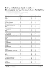
Small Scale Series (1:2 million and smaller)<br />
The status of these charts at the year's end was:<br />
INTERNATIONAL CHARTS<br />
- INT charts projected ................................ ................................ ................................ ............. ..... 95<br />
- INT charts published ................................ ................................ ................................ ............ ..... 84<br />
- INT charts reprinted by other <strong>IHO</strong> Member States ................................ ............................… .... 80<br />
- Number of <strong>IHO</strong> producer nations................................ ............................... .......................…. ..... 17<br />
- Number of <strong>IHO</strong> printer nations ................................ ..............................… ............................ . .. 15<br />
Medium and Large Scale Series (larger than 1:2 million)<br />
i) The production of INT charts at medium and large scales by Member States' Hydrographic<br />
Offices has continued, in accordance with the schemes prepared by <strong>IHO</strong> Regional Charting<br />
Groups or Committees. Sections of M-11 pertaining to INT Regions 'D', 'E', 'F', 'G', „H‟, „I‟,<br />
„J‟, 'K', 'L' and „M‟ have been completed.<br />
ii)<br />
iii)<br />
iv)<br />
INT chart schemes have been adopted in the Regions D (Coord: Netherlands), E (Coord:<br />
Germany), F and G (Coord: France), H (Coord: South Africa), I (Coord: Iran), J (Coord:<br />
India), K (Coord: Japan), L (Coord: Australia; medium scales only), and M (Antarctica -<br />
Coord: IHB).<br />
INT chart schemes for Region B (Coord: Mexico), C1 (Coord: Brazil), and C2 (Coord: Chile)<br />
are in various states of preparation or completion.<br />
No progress was reported on the preparation of an INT chart scheme for Region A (Coord:<br />
USA(NOAA)).