Hamilton Brantford Cambridge Trails - County of Brant
Hamilton Brantford Cambridge Trails - County of Brant
Hamilton Brantford Cambridge Trails - County of Brant

You also want an ePaper? Increase the reach of your titles
YUMPU automatically turns print PDFs into web optimized ePapers that Google loves.
East River Rd.<br />
Thanks to our donors who<br />
helped build the trails<br />
The trails are provided free for public use, but the cost to<br />
acquire the land and build the four trails approached<br />
$1.5 million. The funds were provided by generous<br />
donations from the following corporations, individuals<br />
and like-minded foundations.<br />
Station Masters Honour Roll<br />
<strong>Brant</strong> Waterways Foundation<br />
Canadian General-Tower<br />
Province <strong>of</strong> Ontario<br />
Redland Quarries<br />
Kilometre Club<br />
<strong><strong>Brant</strong>ford</strong> Jaycees<br />
CAA South Central Ontario<br />
Ciba-Geigy<br />
D<strong>of</strong>asco Inc.<br />
Electrohome Ltd.<br />
Green Life Proteins<br />
The McLean Foundation<br />
Trail Supporters<br />
Ancaster High & Vocational School<br />
H.G. Bertram Foundation<br />
<strong><strong>Brant</strong>ford</strong> Community Foundation<br />
<strong>Cambridge</strong> & Kitchener Rotary<br />
CIBC (Halton/Wentworth District)<br />
CKCO-TV - Kitchener<br />
Ron Clark<br />
Cloverleaf Charitable Foundation<br />
Gordon Cockshutt Foundation<br />
Carl Dare<br />
Peter Etril Snyder Galleries<br />
Freeman Foundation<br />
Grand Valley <strong>Trails</strong> Association<br />
Alf & Mary Hales<br />
<strong>Hamilton</strong> Naturalists Club<br />
Kitchener and Waterloo<br />
Community Foundation<br />
John Labbatt Foundation<br />
The Jean Rich Foundation<br />
SC Johnson and Son, Limited<br />
TCG Materials<br />
Trans Canada Trail Foundation<br />
Ken Murray<br />
Peter & Harvey Sims<br />
TD Canada Trust - Friends <strong>of</strong> the<br />
Environment Foundation<br />
Waterfront Regeneration Trust<br />
The W. Garfield Weston<br />
Foundation<br />
Ned Lauder<br />
Malloch Foundation<br />
The R. Samuel McLaughlin<br />
Foundation<br />
George C. Metcalf Charitable<br />
Foundation<br />
William Nelson<br />
Bank <strong>of</strong> Nova Scotia<br />
Ontario Heritage Foundation<br />
Page Foundation<br />
Polymer Technologies<br />
Royal Bank <strong>of</strong> Canada<br />
Charitable Foundation<br />
Fred & Jane Schneider<br />
Samuel W. Stedman Foundation<br />
TransCanada Pipeline<br />
Union Gas<br />
...and many others who helped make the project a success.<br />
If you would like to support continued upgrades and<br />
maintenance <strong>of</strong> our trails, tax deductible<br />
donations can be made to:<br />
Grand River Conservation Foundation<br />
P.O. Box 729, <strong>Cambridge</strong>, ON N1R 5W6<br />
Conservation Foundation <strong>of</strong> the <strong>Hamilton</strong> Region<br />
P.O. Box 7099, Ancaster, ON L9G 3L3<br />
<strong>Brant</strong> Waterways Foundation<br />
38 Darling St., Suite 104, <strong><strong>Brant</strong>ford</strong>, ON N3T 6A8<br />
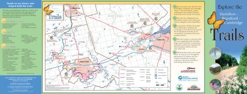
401<br />
<strong>Trails</strong><br />
Pinehurst Lake<br />
Conservation Area<br />
Nith River<br />
53<br />
2<br />
403<br />
The<br />
<strong>Hamilton</strong> -<br />
<strong><strong>Brant</strong>ford</strong> -<br />
<strong>Cambridge</strong><br />
24A<br />
P 58.2 km<br />
Paris<br />
57.4 km<br />
75<br />
Glen Morris Rd.<br />
Grand River<br />
Green Ln.<br />
57.8 km<br />
5<br />
56.8 km<br />
24<br />
97<br />
Glen Morris<br />
67.9 km<br />
P<br />
65 km<br />
61.1 km<br />
53.9 km<br />
P<br />
52.9 km<br />
50.1 km<br />
Alternate<br />
<strong>Brant</strong><br />
Conservation<br />
Area<br />
CAMBRIDGE<br />
Concession St.<br />
77 km<br />
74.6 km<br />
Regional Municipality <strong>of</strong> Waterloo<br />
Map produced by the GRCA using data owned by the Province <strong>of</strong> Ontario and the GRCA.<br />
Copyright © Grand River Conservation Authority, 2007.<br />
Copyright © Queen`s Printer, 2007.<br />
This map may not be reproduced or altered in any way. This map is for illustrative purposes<br />
only. The Grand River Conservation Authority takes no responsibility for, nor guarantees,<br />
the accuracy <strong>of</strong> the information contained on this map. Any interpretations or conclusions<br />
drawn from this map are the sole responsibility <strong>of</strong> the user.<br />
<strong>Brant</strong> Rd.<br />
Blue Lake Rd.<br />
24<br />
Governor’s Rd.<br />
Powerline Rd.<br />
Hardy Rd.<br />
47 km<br />
P<br />
42.5 km<br />
P<br />
5<br />
44.4 km<br />
44.1 km<br />
8<br />
St. George<br />
Osborne<br />
Corners<br />
403<br />
Erie Ave.<br />
99<br />
BRANTFORD<br />
P<br />
32 km<br />
38.9 km<br />
33.2 km<br />
Newport<br />
<strong>County</strong> <strong>of</strong> <strong>of</strong> <strong>Brant</strong><br />
<strong>Brant</strong><br />
18<br />
City <strong>of</strong> <strong>of</strong> <strong>Hamilton</strong><br />
<strong>Hamilton</strong><br />
2/53<br />
Fairchild Creek<br />
25.5 km<br />
26.8 km<br />
30 km<br />
Colborne St.<br />
54<br />
Grand River<br />
Watershed<br />
Governor’s Rd.<br />
Langford<br />
2/53<br />
Grand River<br />
P 18.5 km<br />
<strong>Hamilton</strong><br />
Watershed<br />
Jerseyville<br />
P 12.7 km<br />
Jerseyville Rd.<br />
12.7 km<br />
52<br />
403<br />
Christie Lake<br />
Conservation Area<br />
Trinity Rd.<br />
2<br />
8<br />
5<br />
6<br />
Spencer Gorge/<br />
Webster’s Falls<br />
Conservation Area<br />
5.5 km<br />
P<br />
3.3 km<br />
Dundas<br />
Cootes Dr.<br />
Main St. W<br />
P<br />
0 km<br />
Borer’s Falls<br />
Conservation<br />
Area<br />
Mineral Springs Rd.<br />
12.3 km<br />
Ancaster<br />
Dundas Valley<br />
Conservation Area<br />
Kilometre marker<br />
(see reverse for description)<br />
<strong>Hamilton</strong> to <strong><strong>Brant</strong>ford</strong><br />
Rail Trail<br />
Gordon Glaves<br />
Memorial Pathway<br />
SC Johnson Trail<br />
<strong>Cambridge</strong> to Paris<br />
Rail Trail<br />
Freeway<br />
Highway<br />
Major Road<br />
Municipal<br />
Boundary<br />
Watershed<br />
Boundary<br />
2<br />
Lincoln M. Alexander Pkwy.<br />
P<br />
Upper James St.<br />
403<br />
HAMILTON<br />
Built-up area<br />
Conservation Area<br />
River or Water Body<br />
Parking<br />
Scale:<br />
1 0 1 2 km<br />
Lake Ontario<br />
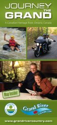
A major trail system now links the cities<br />
<strong>of</strong> <strong>Hamilton</strong>, <strong><strong>Brant</strong>ford</strong> and <strong>Cambridge</strong>.<br />
These 77 kms <strong>of</strong> trail form a major<br />
component in the southern Ontario<br />
loop <strong>of</strong> the Trans Canada Trail System.<br />
In 1993, the City <strong>of</strong> <strong><strong>Brant</strong>ford</strong> commenced<br />
its Gordon Glaves Memorial<br />
Pathway along the scenic Grand River.<br />
When opened in 1994 by the Grand<br />
River Conservation Authority, the<br />
<strong>Cambridge</strong> to Paris Rail Trail was one <strong>of</strong><br />
the first abandoned rail lines to be<br />
converted for recreational trail use in<br />
southern Ontario.<br />
In 1996, the <strong>Hamilton</strong> to <strong><strong>Brant</strong>ford</strong> Rail<br />
Trail was completed by the <strong>Hamilton</strong><br />
Region and Grand River Conservation<br />
Authorities and became Canada’s first<br />
fully developed, entirely <strong>of</strong>f-road<br />
inter-urban trail.<br />
In 1998 these three trails were joined<br />
by the SC Johnson Trail, through the<br />
generosity <strong>of</strong> SC Johnson and Son,<br />
Limited <strong>of</strong> <strong><strong>Brant</strong>ford</strong>, forming a<br />
continuous trail system suitable for<br />
both hiking and bicycle use.<br />
Explore the<br />
<strong>Hamilton</strong> -<br />
<strong><strong>Brant</strong>ford</strong> -<br />
<strong>Cambridge</strong><br />
<strong>Trails</strong>
Explore the<br />
<strong>Hamilton</strong> -<br />
<strong><strong>Brant</strong>ford</strong> -<br />
<strong>Cambridge</strong><br />
<strong>Trails</strong><br />
How the trails came to be<br />
It wasn’t originally planned to build a continuous trail<br />
from <strong>Hamilton</strong> to <strong>Cambridge</strong>. Rather, the trail system<br />
came about through the linking <strong>of</strong> four separate trail<br />
project initiatives.<br />
1 2<br />
<strong><strong>Brant</strong>ford</strong>’s trail system began in the early 1990’s.<br />
Most <strong>of</strong> the pathways were constructed as part <strong>of</strong> the<br />
City’s riverside flood control works and in 1993, the<br />
trail system was named the Gordon Glaves<br />
Memorial Pathway. The trails are<br />
owned and<br />
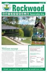
Dundas Valley Trail Centre<br />
The trails between <strong>Hamilton</strong> and <strong>Cambridge</strong> form Canada’s first fully developed,<br />
multi-use inter-urban trail system. Passing through <strong><strong>Brant</strong>ford</strong> and Paris, the trails<br />
extend approximately 80 km and have been formally included as a major<br />
component <strong>of</strong> the Trans Canada Trail system.<br />
The trails <strong>of</strong>fer some <strong>of</strong> the best bicycling and hiking opportunities in southern<br />
Ontario. The route is exceptionally scenic and almost entirely <strong>of</strong>f-road, and many<br />
convenient parking areas have been provided. The trails are<br />
accessible by wheelchairs in most sections and are suitable<br />
for cross-country skiing in the winter months - but no<br />
motorized vehicles are allowed without special permission.<br />
maintained by the City <strong>of</strong> <strong><strong>Brant</strong>ford</strong>, and are<br />
continually expanding with the help <strong>of</strong> community<br />
volunteers, generous sponsors and new partnerships.<br />
The <strong>Cambridge</strong> to Paris Rail Trail was opened in<br />
1994 and follows the abandoned roadbed <strong>of</strong> the old<br />
Lake Erie & Northern Railway. Running right through<br />
the unique Carolinian Grand River Forest, the 18 km<br />
trail is owned and operated by the Grand River<br />
Conservation Authority through funding supplied by<br />
generous donors to the Grand River Conservation<br />
Foundation.<br />
3The third portion <strong>of</strong> the trail was completed in 1996.<br />
Known as the <strong>Hamilton</strong> to <strong><strong>Brant</strong>ford</strong> Rail Trail, it<br />
joins its namesake cities over the 32 km route <strong>of</strong> the<br />
abandoned Toronto, <strong>Hamilton</strong> & Buffalo Railway.<br />
This trail is jointly owned and operated by the<br />
<strong>Hamilton</strong> and Grand River Conservation Authorities.<br />
4<br />
With these trails up and running, there was just a 14<br />
km gap needed to complete the route all the way<br />
from <strong>Hamilton</strong> to <strong>Cambridge</strong>. This missing “link” was<br />
undertaken in 1998 through a generous donation to<br />
the Grand River Conservation Foundation from SC<br />
Johnson and Son, Limited in <strong><strong>Brant</strong>ford</strong>. Known as the<br />
SC Johnson Trail, it links Paris with <strong><strong>Brant</strong>ford</strong>.<br />
Respective portions <strong>of</strong> the trail are owned by the City<br />
<strong>of</strong> <strong><strong>Brant</strong>ford</strong>, Grand River Conservation Authority and<br />
the <strong>County</strong> <strong>of</strong> <strong>Brant</strong>.<br />
Explore the trails! Below are some <strong>of</strong> the<br />
sights and features that walkers and cyclists<br />
will see along the way.<br />
Kilometre distances are marked at most locations<br />
along each <strong>of</strong> the trails, and trailhead parking<br />
areas contain detailed maps <strong>of</strong> the trail sections<br />
you are about to travel.<br />
<strong>Hamilton</strong> to <strong><strong>Brant</strong>ford</strong> Rail Trail<br />
0 km<br />
3.3 km<br />
5.5 km<br />
12.3 km<br />
12.7<br />
18.5 km<br />
25.5<br />
26.8 km<br />
30 km<br />
32 km<br />
<strong>Hamilton</strong> - Trailhead & parking area<br />
Sanctuary Park (rest area & washroom in season)<br />
Dundas Valley Visitor Centre Trailhead & parking<br />
area (washrooms, interpretive hikes and programs in<br />
season, historic train displays)<br />
Steam engines used to fight the steep grade from<br />
<strong>Hamilton</strong> westbound to Summit. Observation deck<br />
overlooking Summit Muskeg Preserve.<br />
Copetown parking area and crossing <strong>of</strong> former<br />
Highway 52. Watch for traffic.<br />
Jerseyville - Redland Quarries and TCG Materials<br />
Trailhead & parking area<br />
“Duck under” Highway 403 beside Fairchild Creek.<br />
Thanks to the Ontario Ministry <strong>of</strong> Transportation for permission<br />
to use this bridge and scenic trail diversion to cross their<br />
highway. Steep grade for wheelchairs.<br />
Bridge crossing Fairchild Creek<br />
Site <strong>of</strong> the 1986 <strong><strong>Brant</strong>ford</strong> landslide which caused<br />
abandonment<br />
<strong>of</strong> this stretch<br />
<strong>of</strong> the railway<br />
line on which<br />
the trail runs.<br />
<strong><strong>Brant</strong>ford</strong><br />
Jaycees<br />
Trailhead<br />
& parking<br />
area<br />
Gordon Glaves Memorial Pathway<br />
32 km<br />
33.2 km<br />
38.9 km<br />
42.5 km<br />
44.1 km<br />
44.1 km<br />
44.4 km<br />
47 km<br />
50.1 km<br />
52.9 km<br />
53.9 km<br />
56.8 km<br />
57.4 km<br />
57.8 km<br />
<strong><strong>Brant</strong>ford</strong> Jaycees Trailhead & parking area (nearby<br />
restaurants & lodging)<br />
Mohawk Chapel, Six Nations Historic Site<br />
<strong>Brant</strong>’s Crossing and Earl Haig Park (parking,<br />
washrooms in season, access to downtown). Alternate<br />
route access to additional 8 km <strong>of</strong> trails and Bell<br />
Homestead across the river.<br />
Waterworks Park parking area<br />
Wilkes Dam<br />
SC Johnson Trail (Paris to <strong><strong>Brant</strong>ford</strong>)<br />
Wilkes Dam -<br />
location <strong>of</strong> the<br />
intake for <strong><strong>Brant</strong>ford</strong>’s<br />
Water Treatment<br />
Plant (limited<br />
parking only)<br />
River vista <strong>of</strong><br />
<strong>Brant</strong> Conservation<br />
Area and rare<br />
prairie grass habitat. Glenhyrst Art Gallery is just up the<br />
hill.<br />
Blue Circle Loop<br />
(Alternate route - bicycle lanes provided on Hardy<br />
Road)<br />
Masters Lane at Hardy Road<br />
Bridge over Highway 403. Thanks to the Ontario Ministry<br />
<strong>of</strong> Transportation for permission to use this former railway<br />
bridge to cross the highway.<br />
SC Johnson parking area (Powerline Road)<br />
Crossing <strong>of</strong> former Highway 2 at Curtis Avenue<br />
(stop lights)<br />
Views <strong>of</strong> Paris at <strong>Hamilton</strong> Technical Ceramics<br />
Overlook<br />
CN Railway underpass<br />
<strong>Cambridge</strong> to Paris Rail Trail<br />
58.2 km<br />
61.1 km<br />
65 km<br />
67.9 km<br />
74.6 km<br />
77 km<br />
Paris - Jean Rich<br />
Foundation Trailhead<br />
& parking area<br />
(nearby lodging,<br />
restaurants & supplies)<br />
The Murray Overlook<br />
(short but steep<br />
grade on trail for<br />
wheelchairs - steps<br />
to overlook)<br />
Spectacular river vista<br />
Glen Morris - old railway station site & parking area<br />
Riverside Lookout<br />
<strong>Cambridge</strong> - Canadian General-Tower Trailhead &<br />
parking area (adjacent food, washrooms & canoe<br />
launching)<br />
To report vandalism, unauthorized use<br />
or trail maintenance concerns:<br />
<strong>Cambridge</strong> to Paris Rail Trail, SC Johnson Trail and<br />
<strong>Hamilton</strong> to <strong><strong>Brant</strong>ford</strong> Rail Trail (between <strong><strong>Brant</strong>ford</strong><br />
and Jerseyville) -<br />
Grand River Conservation Authority (519) 621-2761<br />
Gordon Glaves Memorial Pathway -<br />
City <strong>of</strong> <strong><strong>Brant</strong>ford</strong> Parks & Recreation Dept.<br />
(519) 756-1500<br />
<strong>Hamilton</strong> to<br />
<strong><strong>Brant</strong>ford</strong> Rail<br />
Trail (between<br />
Jerseyville and<br />
<strong>Hamilton</strong>) -<br />
<strong>Hamilton</strong><br />
Conservation<br />
Authority<br />
(905) 525-2181<br />
Photos courtesy <strong>of</strong><br />
Grand River Conservation<br />
Authority, <strong><strong>Brant</strong>ford</strong> Parks<br />
& Recreation, Daria<br />
Rubanetz, Garth Gourlay,<br />
Alan Ernst, <strong><strong>Brant</strong>ford</strong><br />
Expositor and the<br />
<strong>Hamilton</strong> Conservation<br />
Authority.<br />
While on the trails...<br />
The trails are surfaced with stone dust or finer gravel and<br />
are suitable for street bikes as well as mountain bikes. Some<br />
<strong><strong>Brant</strong>ford</strong> sections are paved.<br />
Most <strong>of</strong> the route is suitable for wheelchairs, except in a<br />
couple <strong>of</strong> instances where trail diversions have necessitated<br />
steep grades. Assistance for wheelchair users may be<br />
required in these sections.<br />
Except for inspection and maintenance purposes, no<br />
motorized vehicles are permitted on the trails, and we do<br />
our best to police this unauthorized activity.<br />
Of necessity, some sections <strong>of</strong><br />
the trails utilize roadways within<br />
the City <strong>of</strong> <strong><strong>Brant</strong>ford</strong>, or cross<br />
busy roads and private<br />
laneways. Always be aware <strong>of</strong><br />
vehicular traffic.<br />
Remember that adjacent land<br />
is usually privately owned.<br />
Respect the rights <strong>of</strong> our<br />
neighbours by staying on<br />
the trail, and park only<br />
in designated areas.<br />
Ski the trails<br />
The beauty <strong>of</strong> the trails is that they venture through scenic<br />
country, but remember that they <strong>of</strong>ten travel through<br />
relatively remote areas. In order that everyone can enjoy<br />
these remarkable trails, please follow these common sense<br />
guidelines:<br />
Keep to the right when using the trails<br />
Announce your intention to pass - and allow faster users to pass<br />
safely<br />
Never hike or bike alone - always bring a “buddy”<br />
Trail use closes nightly at dusk<br />
No open fires or camping are permitted along the trails<br />
You won’t see the abundant wildlife if you don’t keep dogs on<br />
their leash<br />
Except where noted, no washrooms are provided along the trails<br />
Park only in designated trailhead parking areas - many have been<br />
provided<br />
To avoid temptation, safely secure valuables in your vehicle, or<br />
take them with you<br />
Trail use is at the users’ risk, and local trail conditions may change<br />
over time