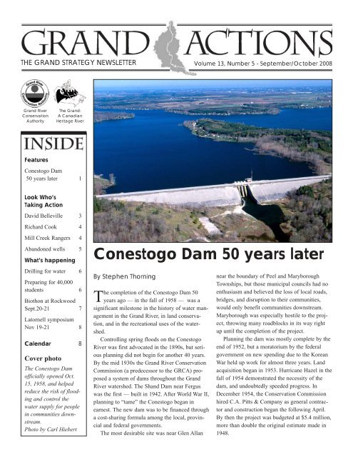
Conestogo Dam 50 years later - Grand River Conservation Authority
Conestogo Dam 50 years later - Grand River Conservation Authority
Conestogo Dam 50 years later - Grand River Conservation Authority

You also want an ePaper? Increase the reach of your titles
YUMPU automatically turns print PDFs into web optimized ePapers that Google loves.
THE GRAND STRATEGY NEWSLETTER Volume 13, Number 5 - September/October 2008<br />
<strong>Grand</strong> <strong>River</strong><br />
<strong>Conservation</strong><br />
<strong>Authority</strong><br />
The <strong>Grand</strong>:<br />
A Canadian<br />
Heritage <strong>River</strong><br />
Features<br />
<strong>Conestogo</strong> <strong>Dam</strong><br />
<strong>50</strong> <strong>years</strong> <strong>later</strong> 1<br />
Look Who’s<br />
Taking Action<br />
David Belleville 3<br />
Richard Cook 4<br />
Mill Creek Rangers 4<br />
Abandoned wells 5<br />
What’s happening<br />
Drilling for water 6<br />
Preparing for 40,000<br />
students 6<br />
Biothon at Rockwood<br />
Sept.20-21 7<br />
Latornell symposium<br />
Nov 19-21 8<br />
Calendar 8<br />
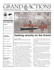
Cover photo<br />
The <strong>Conestogo</strong> <strong>Dam</strong><br />
officially opened Oct.<br />
15, 1958, and helped<br />
reduce the risk of flooding<br />
and control the<br />
water supply for people<br />
in communities downstream.<br />
Photo by Carl Hiebert<br />
<strong>Conestogo</strong> <strong>Dam</strong> <strong>50</strong> <strong>years</strong> <strong>later</strong><br />
By Stephen Thorning<br />
The completion of the <strong>Conestogo</strong> <strong>Dam</strong> <strong>50</strong><br />
<strong>years</strong> ago — in the fall of 1958 — was a<br />
significant milestone in the history of water management<br />
in the <strong>Grand</strong> <strong>River</strong>, in land conservation,<br />
and in the recreational uses of the watershed.<br />
Controlling spring floods on the <strong>Conestogo</strong><br />
<strong>River</strong> was first advocated in the 1890s, but serious<br />
planning did not begin for another 40 <strong>years</strong>.<br />
By the mid 1930s the <strong>Grand</strong> <strong>River</strong> <strong>Conservation</strong><br />
Commission (a predecessor to the GRCA) proposed<br />
a system of dams throughout the <strong>Grand</strong><br />
<strong>River</strong> watershed. The Shand <strong>Dam</strong> near Fergus<br />
was the first — built in 1942. After World War II,<br />
planning to “tame” the <strong>Conestogo</strong> began in<br />
earnest. The new dam was to be financed through<br />
a cost-sharing formula among the local, provincial<br />
and federal governments.<br />
The most desirable site was near Glen Allan<br />
near the boundary of Peel and Maryborough<br />
Townships, but those municipal councils had no<br />
enthusiasm and believed the loss of local roads,<br />
bridges, and disruption to their communities,<br />
would only benefit communities downstream.<br />
Maryborough was especially hostile to the project,<br />
throwing many roadblocks in its way right<br />
up until the completion of the project.<br />
Planning the dam was mostly complete by the<br />
end of 1952, but a moratorium by the federal<br />
government on new spending due to the Korean<br />
War held up work for almost three <strong>years</strong>. Land<br />
acquisition began in 1953. Hurricane Hazel in the<br />
fall of 1954 demonstrated the necessity of the<br />
dam, and undoubtedly speeded progress. In<br />
December 1954, the <strong>Conservation</strong> Commission<br />
hired C.A. Pitts & Company as general contractor<br />
and construction began the following April.<br />
By then the project was budgeted at $5.4 million,<br />
more than double the original estimate made in<br />
1948.
By September 1956, construction of the<br />
<strong>Conestogo</strong> <strong>Dam</strong> was well underway.<br />
A small crew cut trees during the<br />
winter. Pitts had equipment at work as<br />
soon as possible, and work was well<br />
underway at the time of the sod turning<br />
ceremony on May 30, 1955. While the<br />
shovels and trucks worked away on the<br />
dam, acrimony continued among the<br />
various local councils over bridges,<br />
realigned roads, restructured school sections<br />
and other issues. During the summer<br />
of 1955 the site became a tourist<br />
attraction, as did the nearby hamlet of<br />
Hollen, which would largely disappear<br />
under the waters of the reservoir.<br />
The contractor set up a concrete mixing<br />
plant to supply the huge quantity<br />
needed for the dam and its wing walls.<br />
Concrete work continued into the late<br />
fall of 1955 and resumed the following<br />
year. Severe summer storms made a<br />
mess of the project, washing away fill<br />
and holding up work for weeks.<br />
Nevertheless, Pitts completed the concrete<br />
work in the fall of 1956.<br />
Favourable late fall conditions permitted<br />
most of the embankment to be<br />
completed by an army of dump trucks<br />
and scrapers during the summer and fall<br />
of 1956. Employment on the project<br />
peaked at about 1<strong>50</strong>. In December the<br />
commission issued a contract for the<br />
major road work to R.A. Blythe for<br />
$458,000.<br />
There were still outstanding road<br />
issues with the townships, particularly<br />
Maryborough. At the request of the commission,<br />
the provincial Department of<br />
Highways mediated the disputes.<br />
Endless meetings and quarreling took<br />
their toll on the commission in early<br />
1957 and this only added to the frustration<br />
of cost overruns and delays, pushing<br />
completion into 1958.<br />
Aside from the massive gates, work<br />
on the dam was largely complete by the<br />
end of the summer of 1957, despite<br />
some new problems with quicksand and<br />
artesian springs. By then, C.A. Pitts had<br />
poured more than 95,000 cubic yards of<br />
concrete and moved 1,200,000 cubic<br />
yards of fill. Employment on the project<br />
dropped below 100. For the rock facing<br />
on the dam, the commission decided to<br />
use limestone from the GRCC-owned<br />
Elora Quarry. Hauling that rock proceeded<br />
through the summer and fall of 1957.<br />
There was also discussion about the<br />
future uses of the reservoir. Anticipating<br />
demand for recreational uses, and considering<br />
the desirability to reforest some<br />
of the land, the GRCC purchased an<br />
additional 4<strong>50</strong> acres. With <strong>later</strong> additions,<br />
the land acquisitions totalled 5,<strong>50</strong>0<br />
acres.<br />
In late fall crews undertook the delicate<br />
task of installing the 22-ton gates in<br />
the dam. GRCC engineers ran a series of<br />
tests over the winter and spring of 1958.<br />
Everything worked well, and the reservoir<br />
filled slowly during the summer.<br />
There was more good news from the<br />
accountants: the dam had come in at its<br />
original budget.<br />
With the dam itself virtually completed,<br />
road and bridge work took place during<br />
the summer of 1958. The most<br />
important of those roads was the Peel-<br />
Maryborough town line, which was<br />
rerouted to pass over the top of the dam.<br />
It was also paved, to help deal with the<br />
anticipated heavy traffic by recreational<br />
users of the lake.<br />
The GRCC set Oct. 15, 1958 as the<br />
official completion date. There was no<br />
ceremony that day, perhaps because of<br />
the lingering animosity among the various<br />
political entities. The dam immediately<br />
showed its value in taming spring<br />
floods and rapid runoff from summer<br />
storms. The lake soon became a haven<br />
for cottagers and recreational users.<br />
Today, a half century <strong>later</strong>, it is difficult<br />
to imagine the <strong>Conestogo</strong> <strong>River</strong> without<br />
its dam.<br />
This article appears in <strong>Grand</strong> Actions<br />
courtesy of the author and the<br />
Wellington Advertiser.<br />
The <strong>Conestogo</strong> <strong>Dam</strong> has led to new recreational opportunities, such as boating, sailing,<br />
swimming and improved fishing on the reservoir at <strong>Conestogo</strong> Lake<br />
<strong>Conservation</strong> Area.<br />
2<br />
Share the resources - Share the responsibility
Belleville leads volunteers to clean up garbage<br />
David Belleville is one of six recipients<br />
of the 2008 Watershed Awards<br />
which will be given out in October.<br />
These awards honour those who have<br />
put their time and effort into making the<br />
<strong>Grand</strong> <strong>River</strong> watershed a better place to<br />
live. Richard Cook, featured on the following<br />
page, will also receive a<br />
Watershed Award. Stories on Woolwich<br />
Clean Waterways, the Port Maitland<br />
Historical Society, Phil and Katie<br />
Wilman and Doug Ratz will be featured<br />
in future issues of <strong>Grand</strong> Actions.<br />
By Janet Baine<br />
GRCA Communications Specialist<br />
Other people’s garbage is what David<br />
Belleville has been cleaning up for<br />
the past 10 <strong>years</strong>.<br />
“You could be picking up bags and<br />
bags and bags of garbage for the rest of<br />
your life and then you could come back<br />
here to do it all over again,” he says.<br />
Often the people who leave litter by<br />
the river or on trails are the exact same<br />
ones who come to enjoy recreational<br />
opportunities, such as hiking and fishing.<br />
When they go home, their fast food<br />
wrappers, coffee cups, dirty diapers, bait<br />
containers and plastic water bottles<br />
Look Who’s<br />
Taking Action<br />
remain behind.<br />
On a sunny summer evening, within a<br />
couple of minutes of arriving at the<br />
Cockshutt bridge river access in South<br />
Brantford, Belleville has pulled together<br />
a pile that includes all of these items. He<br />
retrieved some from the bushes where<br />
they were hidden.<br />
If people aren’t going to use the<br />
waste bins, Belleville would prefer that<br />
they leave their garbage out in the open<br />
where it is easy for volunteers to find.<br />
“I know none of this stuff was here a<br />
month ago when the volunteers cleaned<br />
up. Can you imagine what it would look<br />
like if volunteers didn’t pick up garbage<br />
regularly?” he says.<br />
Belleville is a life-long Brantford resident<br />
and works as a technical writer. He<br />
co-chairs the Brantford Brownfields<br />
committee which has been successful in<br />
getting $12 million in funding. He is<br />
chair of the Beautiful Brantford<br />
Committee and calls up teams of volunteers<br />
to undertake clean ups. He doesn’t<br />
like making those calls, but the need is<br />
Clean up of the Cockshutt access in 2004 meant bringing tonnes of garbage to the<br />
local landfill site using city trucks. Now, volunteer crews clean it up regularly.<br />
Dave Belleville, chair of the Beautiful<br />
Brantford Committee, uses a reacher to<br />
retrieve a bait container that has been<br />
thrown into the bushes. Hiding garbage<br />
makes it harder for volunteers to<br />
retrieve.<br />
always there and people keep coming to<br />
clean up. Some groups, such as the<br />
Wilfrid Laurier/Mohawk Environmental<br />
Group, have taken on sections of the<br />
river. A fishing group is looking after the<br />
Cockshutt river access.<br />
Belleville does his best to make the<br />
job less onerous for volunteers. For<br />
instance, he has several “reachers”<br />
(these are available at home health care<br />
stores), so volunteers don’t need to bend<br />
down and use their hands to pick up<br />
garbage. He had metal poles fitted with<br />
a hook to pull items such as bicycles out<br />
of the river. There are also large fry baskets<br />
used to make french fries that skim<br />
items off the top of the river.<br />
Many local businesses have contributed<br />
items for clean up crews.<br />
“I never give up and just keep hoping<br />
there is going to be someone there to<br />
continue with this work,” he says.<br />
GRAND ACTIONS • September/October 2008 3
As a volunteer dam operator, Richard Cook goes out at all hours and in all weather<br />
to ensure the Wellesley <strong>Dam</strong> is properly adjusted to prevent flooding. He has held<br />
this position since taking over from his father-in-law over 20 <strong>years</strong> ago.<br />
Cook braves stormy weather<br />
to keep Wellesley safe<br />
By Janet Baine<br />
GRCA Communications Specialist<br />
Richard Cook has saved the<br />
Wellesley <strong>Dam</strong> by maintaining the<br />
pond levels many times over the past 20<br />
<strong>years</strong>.<br />
In fact he is the only volunteer small<br />
dam operator the GRCA has and he<br />
reacts to situations 24/7.<br />
“I can recall numerous times Richard<br />
has saved the Wellesley structure during<br />
spring runoff and extreme rainfall<br />
events,” says Ron Bloomfield, water<br />
structures maintenance coordinator with<br />
the GRCA. This is an especially<br />
“flashy” waterway and prompt reaction<br />
is required, usually in the early morning<br />
during bad weather.<br />
The dam is at the heart of the picturesque<br />
community west of Waterloo. It is<br />
on Firella Creek which feeds into the<br />
Nith <strong>River</strong>. Cook’s home looks out onto<br />
the pond, so he can monitor the flows<br />
from his window.<br />
He is always carefully attuned to the<br />
weather, especially when there are<br />
storms and during the spring thaw.<br />
Cook’s responsibility is to open the<br />
flood gate to let the high flows pass<br />
through the dam, then close it back<br />
down to maintain the pond level. If he<br />
were not diligently watching, the water<br />
could overtop the dam, resulting in damage<br />
to the structure and possibly the loss<br />
of the pond.<br />
The dam dates back to the early<br />
1900s when it was an old mill dam.<br />
Until 2005 when a new electric<br />
hydraulic gate was installed, the gate<br />
took 15 minutes of intensive pumping to<br />
open. It also frequently froze shut.<br />
“I’ve carried many a pail of hot water<br />
over there in the middle of the night,”<br />
Cook says. The new system drives the<br />
gate up or down, so the gate doesn’t<br />
stick or freeze.<br />
Cook was a volunteer firefighter for<br />
22 <strong>years</strong>, so the dam operator position<br />
was a good fit for him. “He has had the<br />
safety training to handle any of the challenges<br />
that come his way,” says<br />
Bloomfield.<br />
When he is at the dam, his wife usually<br />
takes up a position at the window<br />
looking out to ensure that he is okay. He<br />
is married to the former volunteer dam<br />
operator’s daughter, so inheriting the<br />
volunteer job a few <strong>years</strong> <strong>later</strong> seemed<br />
appropriate.<br />
Cook was hired by the GRCA to construct<br />
a new control building on the<br />
dam.<br />
“Richard takes a huge burden off of<br />
our emergency response field staff,<br />
which is already stretched during spring<br />
runoff and extreme weather events,”<br />
Bloomfield says.<br />
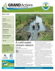
Teens improve Mill<br />
Creek over summer<br />
T<br />
hree high school students spent their<br />
summer making Mill Creek colder,<br />
deeper and narrower so it will be a better<br />
place for fish to live.<br />
Matthew Boyd of Cambridge, Kurtis<br />
Cruickshank of Paris and Dana Potje of<br />
Drumbo worked on the creek in<br />
Puslinch Township through the Mill<br />
Creek Rangers program. The program is<br />
sponsored by Friends of Mill Creek,<br />
which solicits community support, and it<br />
is administered by the GRCA.<br />
Recovery of the cold water stream is<br />
slow and labour-intensive. The teens,<br />
under direction of crew leader Jennifer<br />
Harvard, spent much of their summer<br />
working on the same section of stream<br />
where last year’s rangers worked.<br />
The 2007 ranger crew removed trees<br />
from the creek, opening the channel to<br />
increase the speed of the water and flush<br />
sediments. Over the course of the year,<br />
the faster water exposed more trees that<br />
had been buried. The teens took these<br />
out of the channel this summer and then<br />
anchored them in place at the edge of<br />
the creek to further narrow and deepen<br />
the channel. This allows water to flow<br />
even faster, giving the stream energy to<br />
move sediment that had accumulated on<br />
the bottom.<br />
Harvard said the stream improved<br />
between last summer and this one and<br />
also during the course of this summer.<br />
4<br />
Share the resources - Share the responsibility
Mill Creek Rangers Matthew Boyd and Dana Potje spent their summer anchoring logs in place along the edge of Mill Creek<br />
in Puslinch to make the creek narrower, deeper and faster so it would be better habitat for fish. The Mill Creek Rangers program<br />
has been operating for several <strong>years</strong>. Also part of the program are Kurtis Cruickshank (not pictured here) and crew<br />
leader Jennifer Harvard.<br />
Finding old lost wells and making them safe<br />
By Janet Baine<br />
GRCA Communications Specialist<br />
Tim Patterson is on a quest to find<br />
forgotten wells that are on GRCA<br />
land.<br />
The GRCA owns 20,000 hectares<br />
acquired for parks, reservoirs and nature<br />
preserves and much of it was once farmland<br />
with barns and homes that have<br />
been abandoned. In the past, the old<br />
wells were often left untouched or inadequately<br />
filled in or covered over<br />
because there was little awareness of the<br />
safety and environmental risk they<br />
posed.<br />
Patterson uses old aerial photos and<br />
consults park superintendents and other<br />
GRCA staff who send him in the right<br />
direction to find the old wells. Over the<br />
past three <strong>years</strong>, Patterson has visited<br />
200 sites and found 80 old wells.<br />
“I think I’m three-quarters of the way<br />
there in searching the land. I think there<br />
are another 20 or so more wells to find,”<br />
Patterson says.<br />
The reason for this quest is that property<br />
owners are legally responsible to<br />
properly decommission old wells. They<br />
must locate the wells and have them<br />
decommissioned by a licensed well<br />
driller.<br />
The GRCA, which was the first conservation<br />
authority in the province to<br />
become ISO 14001 registered, is following<br />
this stringent international environmental<br />
standard, and has committed to<br />
identifying and decommissioning all the<br />
abandoned wells on GRCA-owned land.<br />
So far, Patterson hasn’t fallen into<br />
any wells, but he has found some that<br />
would have been a danger for anyone<br />
who chanced upon them. Property owners<br />
need to be aware of the risk these old<br />
wells pose.<br />
Last February a nine-year-old girl fell<br />
into a well on a Cayuga farm and<br />
plunged 18 metres into frigid water. She<br />
was rescued, but the event underlines the<br />
safety hazard of old wells.<br />
They also provide a pathway for contaminants<br />
to enter the aquifer. In this<br />
watershed, 82 per cent of the population<br />
relies on groundwater.<br />
The average cost of properly decommissioning<br />
a typical well is $1,<strong>50</strong>0, but<br />
the actual cost depends on the state of<br />
the well and whether it has been contaminated.<br />
Two of the 41 wells on GRCA property<br />
that have been decommissioned so<br />
far were contaminated. They were at<br />
Laurel Creek <strong>Conservation</strong> Area and<br />
contaminated with a 1.6 metre layer of<br />
kerosene. They cost over $25,000 to<br />
decommission.<br />
In his search for old wells, Patterson<br />
has a better sense of watershed history<br />
Tim Patterson uses a GPS unit to help<br />
find old wells on GRCA land.<br />
GRAND ACTIONS • September/October 2008 5
Not many abandoned wells are as easy<br />
to find as this one in the middle of a<br />
farm field.<br />
— he has visited old ruins and homesteads<br />
and can picture what life may<br />
have been like for the early residents<br />
who once lived there.<br />
To learn more about abandoned<br />
wells, check the water section of<br />
www.grandriver.ca. If you suspect you<br />
know where a well may be on GRCA<br />
property, please call Tim Patterson at<br />
519-621-2763, ext. 2288.<br />
Funding for private wells<br />
If you are concerned about an old<br />
well on your own property, you may be<br />
eligible for funding assistance to have it<br />
decommissioned.<br />
Through the Rural Water Quality<br />
Program, more than 200 wells on private<br />
land have been properly plugged. There<br />
are a number of funding sources to help.<br />
In addition, the provincial government<br />
recently made funding available<br />
through the Source Protection Program<br />
to help pay for decommissioning in<br />
wellhead protection areas.<br />
Contact Tracey Ryan at the Rural<br />
Water Quality Program to find out more<br />
about decommissioning old wells on private<br />
property at 519-621-2763, ext.<br />
2269.<br />
WHAT’S<br />
HAPPENING?<br />
Drilling for water<br />
A<br />
$300,000 contract for the next<br />
phase of a three-year study to find<br />
an ancient buried river valley has been<br />
awarded to All Terrain Drilling Ltd.<br />
About seven boreholes will be drilled<br />
in three areas — north of Paris extending<br />
southeast of Lynden (three holes),<br />
Southwest of Kitchener between Ayr and<br />
Roseville (two holes), and on the north<br />
side of Wellesley (one or two holes).<br />
Drilling will take place between mid-<br />
September and November. Residents in<br />
the vicinity of the drilling will be notified<br />
before it gets underway.<br />
At its eastern end in the City of<br />
Hamilton, the ancient river channel cuts<br />
through the Niagara Escarpment where it<br />
forms the Dundas Valley. One study<br />
done under the Burlington Bay Skyway<br />
showed that the valley may be 75 metres<br />
below sea level, which would make it<br />
about 140 metres below the surface of<br />
Lake Ontario.<br />
The river valley could be millions of<br />
<strong>years</strong> old. Advancing glaciers reshaped<br />
the landscape more than 10,000 <strong>years</strong><br />
ago and the ancient river valley was<br />
filled in. When the glaciers melted, the<br />
water they released helped shape the<br />
modern landscape including the <strong>Grand</strong><br />
<strong>River</strong>, said Gregg Zwiers, senior hydrogeologist<br />
with the GRCA, who is leading<br />
the study.<br />
The first part of the study involved<br />
gathering existing data about the<br />
bedrock valley from water well records,<br />
gas well records, aerial photos and other<br />
studies. Researchers have also conducted<br />
geophysical gravity surveys to develop a<br />
cross-section of the valley. This led to<br />
the selection of the sites for the drilling.<br />
“This research will give us more<br />
information to determine how stressed<br />
our water resources are. The investigation<br />
will help us with source water protection<br />
and our water budget,” Zwiers<br />
said.<br />
The drilling is especially important to<br />
help discover the dimensions of the valley<br />
and what kind of material has filled<br />
it in. If it proves to be narrow, deep and<br />
filled with loose material, it could be a<br />
significant source of groundwater which<br />
could be tapped by municipalities.<br />
Early next year all the research that<br />
has been compiled will be brought<br />
together to form as complete an understanding<br />
as possible of the river valley<br />
and an analysis of the potential source<br />
for municipal water supplies.<br />
The GRCA has been working with<br />
geologists from the Ontario Geological<br />
Survey, a branch of the Ministry of<br />
Northern Development and Mines and<br />
the ministry is contributing about<br />
$660,000.<br />
“I am pleased that the Ontario government<br />
is supporting this important<br />
study,” said Northern Development and<br />
Mines Minister Michael Gravelle.<br />
“Groundwater is one of our most precious<br />
resources and only by learning<br />
more about it can we understand how to<br />
manage it effectively for the future benefit<br />
of Ontarians.” Other agencies<br />
involved in the study include municipalities,<br />
provincial ministries, conservation<br />
authorities and universities.<br />
Nature centres ready<br />
for 40,000 students<br />
in 2008-2009<br />
The GRCA will deliver outdoor education<br />
programs to more than<br />
40,000 school children over the course<br />
of the next school year.<br />
This year new programs will expand<br />
those available at Rockwood<br />
<strong>Conservation</strong> Area. Caving and geology<br />
and water study programs were already<br />
available, but now orienteering using<br />
GPS units and canoeing will also be<br />
available, taking advantage of the unique<br />
glacial geology of the area.<br />
All of the nature centre programs are<br />
6<br />
Share the resources - Share the responsibility
directly linked to the Ontario Ministry of<br />
Education curriculum. The provincial<br />
science curriculum was revised for 2008,<br />
and nature centre staff spent much of the<br />
summer developing new programs and<br />
reworking existing ones so that all the<br />
programs fit with the grade level and the<br />
curriculum requirements.<br />
Students from the <strong>Grand</strong> Erie and<br />
Brant Haldimand Norfolk Catholic<br />
school boards will attend nature centre<br />
programs at Apps’ Mill near Brantford<br />
and Taquanyah near Cayuga. Waterloo<br />
Catholic students will attend programs at<br />
Laurel Creek in Waterloo and Shade’s<br />
Mills in Cambridge, and Wellington<br />
Catholic board students visit Guelph<br />
Lake Nature Centre.<br />
Additional programs are offered on a<br />
non-contract/daily basis to students of<br />
the Upper <strong>Grand</strong> board at Guelph Lake<br />
and Rockwood. The Waterloo Region<br />
District School Board’s outdoor education<br />
program shares the GRCA facilities<br />
at Laurel Creek.<br />
Over the past 30 <strong>years</strong> there has been<br />
tremendous advancement in internet<br />
technology and access to environmental<br />
information. But taking kids outside to<br />
discover the natural world first-hand<br />
through experiential learning, is the<br />
proven best way students learn about<br />
their relationship to the environment on<br />
which we all ultimately depend.<br />
Natural ambassadors program<br />
There are many students who don’t<br />
have the opportunity to attend GRCA<br />
nature centre programs due to lack of<br />
financial resources.<br />
Individuals, groups and companies<br />
can now help children become tomorrow’s<br />
natural ambassadors by adopting a<br />
class through the Natural Ambassadors<br />
Environmental Education Program that<br />
is offered by the <strong>Grand</strong> <strong>River</strong><br />
<strong>Conservation</strong> Foundation.<br />
A class will go to one of five GRCA<br />
nature centres where they will experience<br />
outdoor programs. A Full-day program<br />
sponsorship is $300 while a half<br />
day program is $1<strong>50</strong>. The class may be<br />
specified by the donor or the funds will<br />
be applied toward a school in need.<br />
Donors will receive a receipt for a tax<br />
donation.<br />
The Laurel Creek Nature Centre<br />
recently received a new “Living Roof”<br />
courtesy of donors to the <strong>Grand</strong> <strong>River</strong><br />
<strong>Conservation</strong> Foundation, while Apps’<br />
Mill and Taquanyah now have wind and<br />
solar alternative energy demonstrations.<br />
For more information on the nature<br />
centres or the natural ambassadors program<br />
please visit www.grandriver.ca or<br />
call 519-621-2761.<br />
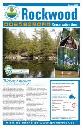
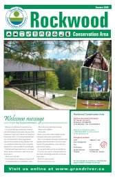
An expanded series of nature centre programs are offered at the Rockwood<br />
<strong>Conservation</strong> Area including one focused on caving and geology. These caves are<br />
also a location where the biothon team will be searching for bats Sept. 20-21.<br />
Counting critters<br />
at Rockwood Biothon<br />
Sept. 20 & 21<br />
A24-hour search for creatures of all<br />
varieties is taking place in the<br />
Rockwood <strong>Conservation</strong> Area Sept. 20<br />
and 21.<br />
This is the fifth annual <strong>Grand</strong> <strong>River</strong><br />
Watershed Biothon, a fundraising project<br />
organized by staff at the <strong>Grand</strong> <strong>River</strong><br />
<strong>Conservation</strong> <strong>Authority</strong> to raise over<br />
$5,000 for outdoor education.<br />
This is the first time the event has<br />
been held at Rockwood, because it<br />
moves to a different GRCA location<br />
each year.<br />
Search teams are anchored by GRCA<br />
staff, but include area naturalists and<br />
helpers. The teams hunt for as many different<br />
species as they can find in a 24-<br />
hour period on the grounds of the conservation<br />
area. Team members collect<br />
pledges for each species they identify in<br />
three categories: vertebrates, invertebrates<br />
and plants.<br />
Join in on the many fun free family<br />
activities Sunday Sept. 21, 1:30 p.m. to<br />
4 p.m., including:<br />
• It’s a Bug Life: catch spineless<br />
wonders with a sweep net<br />
• Mother Nature Bingo: identify local<br />
plants and animals<br />
• Wildlife demonstrations, including<br />
bird banding<br />
• Cave exploration<br />
• Nature Walk: guided walking tours<br />
through the conservation area in search<br />
of wildflowers and whatever walks, hops<br />
or flies<br />
There will also be a lunchtime campfire<br />
cookout, a silent auction and visitors<br />
can purchase and tie-dye a biothon t-<br />
shirt.<br />
Donations will be gratefully accepted<br />
at the nature centre during the Biothon<br />
or online at www.grandriver.ca (under<br />
education and nature centres).<br />
For more information about the biothon,<br />
call 519-836-7860 or 519-856-<br />
9543 or e-mail vfieldwebster@grandriver.ca.<br />
GRAND ACTIONS • September/October 2008 7
Local solutions<br />
for global challenges<br />
Nov. 19-21<br />
The theme of the 15th annual A.D.<br />
Latornell <strong>Conservation</strong> Symposium<br />
is Local Solutions for Global<br />
Challenges.<br />
The event takes place Nov. 19-21at<br />
the Nottawasaga Inn in Alliston, Ontario.<br />
The 2008 theme focuses on the<br />
urgent need to rethink how we manage<br />
local natural resources in order to adapt<br />
to a changing global environment. In<br />
addition to exploring some of the global<br />
About <strong>Grand</strong> Actions<br />
This newsletter is produced bi-monthly<br />
by the <strong>Grand</strong> <strong>River</strong> <strong>Conservation</strong><br />
<strong>Authority</strong> on behalf of the partners in<br />
The <strong>Grand</strong> Strategy. Current and back<br />
issues are available online at:<br />
www.grandriver.ca.<br />
For information on<br />
The <strong>Grand</strong> Strategy contact:<br />
Barbara Veale, GRCA<br />
400 Clyde Road, Box 729,<br />
Cambridge, ON, N1R 5W6<br />
Phone: 519-621-2763 Ext. 2274<br />
Fax: 519-621-4844<br />
E-mail: bveale@grandriver.ca<br />
For newsletter submissions, contact:<br />
Janet Baine, editor<br />
Phone: 519-621-2763, Ext. 2302<br />
Fax: 519-621-4844<br />
E-mail: jbaine@grandriver.ca<br />
Deadlines for submissions are the<br />
15th of February, April, June, August,<br />
October and December. Submissions<br />
may be edited for length or style.<br />
Tax deductible donations and sponsorships<br />
toward the cost of producing<br />
this newsletter are always welcome.<br />
Publications Mail<br />
Agreement #144871<br />
challenges, delegates will discuss gaps<br />
in local policies and programs as well as<br />
ensuring that the science is communicated<br />
in a clear and understandable way.<br />
Keynote speakers<br />
include politician<br />
and diplomat<br />
Stephen Lewis,<br />
Elizabeth May,<br />
leader of the Green<br />
Party of Canada<br />
and Bob<br />
Stephen Lewis McDonald, host of<br />
CBC’s Quirks and Quarks. The symposium<br />
features the pioneer award presentations,<br />
an exhibitors gallery and a<br />
dream auction as well as original student<br />
research and presentations.<br />
Grants available<br />
Grants are available to students and<br />
active members of the conservation<br />
community so that they may attend the<br />
symposium.<br />
For more information about the<br />
grants or symposium visit www.latornell.ca<br />
or call 705-424-0297.<br />
The <strong>Grand</strong> Strategy Calendar<br />
Reflecting Change ~ Mirrored in the Water, the 8th Annual <strong>Grand</strong> <strong>River</strong><br />
Watershed Water Forum, GRCA, 400 Clyde Rd., Cambridge, Friday, Sept.<br />
19, 8 a.m. to 3:30 p.m. The focus of the forum is to explore innovative ways to<br />
address changes that impact water quality and watershed health in the <strong>Grand</strong><br />
<strong>River</strong> watershed. To learn more and to register, please check the conferences<br />
section of the website at www.grandriver.ca or call Sonia Morgan at 519-621-<br />
2763, ext. 2309.<br />
The <strong>Grand</strong> <strong>River</strong> Biothon, Rockwood <strong>Conservation</strong> Area, Sept. 20 & 21.<br />
Over 24 hours, volunteer teams search to discover and record as many different<br />
living things as possible to raise money to support environmental education at<br />
the nature centres. A free family event on Sunday 1:30 p.m. to 4 p.m. features<br />
many activities, including Mother Nature Bingo, wildlife demonstrations, cave<br />
explorations, guided nature walks and bug catching. For more information call<br />
519-836-7860. The biothon raises funds for outdoor education and donations<br />
will be gratefully accepted.<br />
Creating Healthy Communities From Design to Practice, Oct. 9, 8:45<br />
a.m. to 3:15 p.m., Centre Wellington Sportsplex, Fergus. This workshop<br />
brings together local planners and decision-makers from the Waterloo,<br />
Wellington, Dufferin and Guelph area. Keynote speakers include Guelph mayor<br />
Karen Farbridge, a representative of the Ontario Professional Planners Institute<br />
and Marni Ratzel and Tracy Winfree — bicycle and pedestrian transportation<br />
planners for the City of Boulder Colorado. Registration is $20 and includes<br />
lunch. For more information, call 519-846-2715 or 1-800-265-7293 or e-mail<br />
Johanna.monckton@wdghu.org.<br />
<strong>Grand</strong> <strong>River</strong> Spey Play Day, Bean Park, Paris, Saturday Oct. 18, 9 a.m.<br />
to 4 p.m. Staff and rods will be on hand to help with casting instructions and<br />
answer questions people have. The event is free. For more information, contact<br />
randyflyfisher@rogers.com or visit www.grandriverspey.ca.<br />
A.D. Latornell <strong>Conservation</strong> Symposium, Nottawasaga Inn, Alliston,<br />
November 19-21. This is Ontario’s premier conservation conference and the<br />
theme is Local Solutions for Global Challenges. For more information, visit<br />
www.latornell.ca or see the story above.<br />
8<br />
Share the resources - Share the responsibility