INDIAN NOTICES TO MARINERS - National Hydrographic Office
INDIAN NOTICES TO MARINERS - National Hydrographic Office
INDIAN NOTICES TO MARINERS - National Hydrographic Office
You also want an ePaper? Increase the reach of your titles
YUMPU automatically turns print PDFs into web optimized ePapers that Google loves.
2.2<br />
189(15/12) IRAN – Khuran (Clarence Strait)– Pilot Boarding.<br />
Source: BA Chart 3599<br />
Chart 8004 [previous update 066/12]<br />
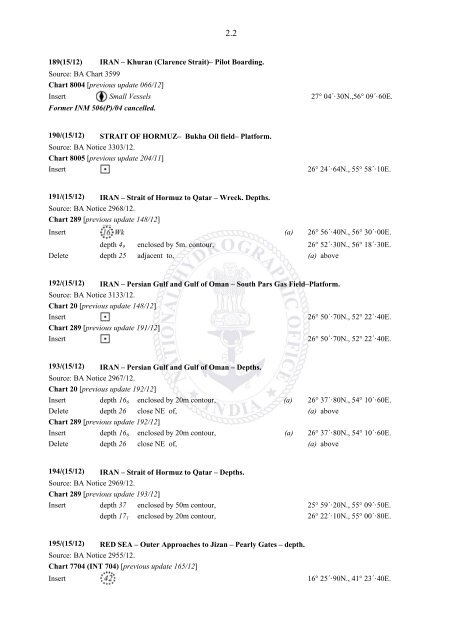
Insert Small Vessels 27° 04´·30N.,56° 09´·60E.<br />
Former INM 506(P)/04 cancelled.<br />
190/(15/12) STRAIT OF HORMUZ– Bukha Oil field– Platform.<br />
Source: BA Notice 3303/12.<br />
Chart 8005 [previous update 204/11]<br />
Insert<br />
26° 24´·64N., 55° 58´·10E.<br />
191/(15/12) IRAN – Strait of Hormuz to Qatar – Wreck. Depths.<br />
Source: BA Notice 2968/12.<br />
Chart 289 [previous update 148/12]<br />
Insert (a) 26° 56´·40N., 56° 30´·00E.<br />
depth 4 9 enclosed by 5m. contour, 26° 52´·30N., 56° 18´·30E.<br />
Delete depth 25 adjacent to, (a) above<br />
192/(15/12) IRAN – Persian Gulf and Gulf of Oman – South Pars Gas Field–Platform.<br />
Source: BA Notice 3133/12.<br />
Chart 20 [previous update 148/12]<br />
Insert<br />
Chart 289 [previous update 191/12]<br />
Insert<br />
26° 50´·70N., 52° 22´·40E.<br />
26° 50´·70N., 52° 22´·40E.<br />
193/(15/12) IRAN – Persian Gulf and Gulf of Oman – Depths.<br />
Source: BA Notice 2967/12.<br />
Chart 20 [previous update 192/12]<br />
Insert depth 16 6 enclosed by 20m contour, (a) 26° 37´·80N., 54° 10´·60E.<br />
Delete depth 26 close NE of, (a) above<br />
Chart 289 [previous update 192/12]<br />
Insert depth 16 6 enclosed by 20m contour, (a) 26° 37´·80N., 54° 10´·60E.<br />
Delete depth 26 close NE of, (a) above<br />
194/(15/12) IRAN – Strait of Hormuz to Qatar – Depths.<br />
Source: BA Notice 2969/12.<br />
Chart 289 [previous update 193/12]<br />
Insert depth 37 enclosed by 50m contour, 25° 59´·20N., 55° 09´·50E.<br />
depth 17 1 enclosed by 20m contour, 26° 22´·10N., 55° 00´·80E.<br />
195/(15/12) RED SEA – Outer Approaches to Jizan – Pearly Gates – depth.<br />
Source: BA Notice 2955/12.<br />
Chart 7704 (INT 704) [previous update 165/12]<br />
Insert<br />
16° 25´·90N., 41° 23´·40E.


