

Godey Creek Trail - Gold Country
Godey Creek Trail - Gold Country
Godey Creek Trail - Gold Country

Create successful ePaper yourself
Turn your PDF publications into a flip-book with our unique Google optimized e-Paper software.
Site Identification<br />
Nearest Community:<br />
Geocache Location:<br />
Altitude:<br />
Accuracy:<br />
Overall terrain:<br />
Overall terrain difficulty:<br />
Ownership:<br />
Access and Restrictions:<br />
Parking:<br />
Letterbox Clues:<br />
Merritt, BC<br />
N 50 05.291<br />
W120 44.683<br />
696m<br />
3 metres<br />
1.5<br />
2 (1=easiest;5=hardest)<br />
BC Parks<br />
British Columbia<br />
Visitor Info Centre at<br />
the junction of<br />
Highway 5 and 97c.<br />
Park at the Info<br />
Centre<br />
From the gate to the<br />
<strong>Godey</strong> <strong>Creek</strong> <strong>Trail</strong>s<br />
take the left path,<br />
follow until you go<br />
through a small<br />
gulley. Turn left<br />
walk to small stand<br />
of Spruce trees<br />
cache is under<br />
For more information or to report a<br />
problem with this site please contact:<br />
<strong>Gold</strong> <strong>Country</strong> Communities Society<br />
PO. Box 933<br />
Cache <strong>Creek</strong>, BC.,<br />
V0K 1H0<br />
Tel: 1-877-453-9467<br />
email: info@exploregoldcountry.com<br />
For more site pages go to:<br />
www.goldtrail.com<br />
Apply Sticker Here<br />
Code:GC3PBCZ<br />
Written and<br />
Researched by<br />
Vesta Giles<br />
Rails and <strong>Trail</strong>s<br />
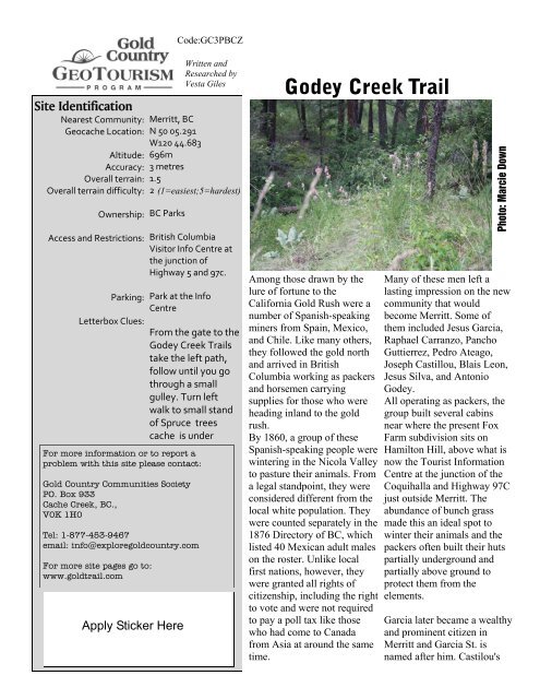
<strong>Godey</strong> <strong>Creek</strong> <strong>Trail</strong><br />
Among those drawn by the<br />
lure of fortune to the<br />
California <strong>Gold</strong> Rush were a<br />
number of Spanish-speaking<br />
miners from Spain, Mexico,<br />
and Chile. Like many others,<br />
they followed the gold north<br />
and arrived in British<br />
Columbia working as packers<br />
and horsemen carrying<br />
supplies for those who were<br />
heading inland to the gold<br />
rush.<br />
By 1860, a group of these<br />
Spanish-speaking people were<br />
wintering in the Nicola Valley<br />
to pasture their animals. From<br />
a legal standpoint, they were<br />
considered different from the<br />
local white population. They<br />
were counted separately in the<br />
1876 Directory of BC, which<br />
listed 40 Mexican adult males<br />
on the roster. Unlike local<br />
first nations, however, they<br />
were granted all rights of<br />
citizenship, including the right<br />
to vote and were not required<br />
to pay a poll tax like those<br />
who had come to Canada<br />
from Asia at around the same<br />
time.<br />
Photo: Marcie Down<br />
Many of these men left a<br />
lasting impression on the new<br />
community that would<br />
become Merritt. Some of<br />
them included Jesus Garcia,<br />
Raphael Carranzo, Pancho<br />
Guttierrez, Pedro Ateago,<br />
Joseph Castillou, Blais Leon,<br />
Jesus Silva, and Antonio<br />
<strong>Godey</strong>.<br />
All operating as packers, the<br />
group built several cabins<br />
near where the present Fox<br />
Farm subdivision sits on<br />
Hamilton Hill, above what is<br />
now the Tourist Information<br />
Centre at the junction of the<br />
Coquihalla and Highway 97C<br />
just outside Merritt. The<br />
abundance of bunch grass<br />
made this an ideal spot to<br />
winter their animals and the<br />
packers often built their huts<br />
partially underground and<br />
partially above ground to<br />
protect them from the<br />
elements.<br />
Garcia later became a wealthy<br />
and prominent citizen in<br />
Merritt and Garcia St. is<br />
named after him. Castilou's
son, Henry, became a well-known lawyer and<br />
judge in BC. Little is known about Antonio<br />
<strong>Godey</strong>, who the creek and trails were named<br />
after. It is known that he pre-empted Lot 711<br />
near Garcia Lake in 1889 and that he passed<br />
away in 1904. His son, Jamie, was born at 86<br />
Mile House, between Spences Bridge and<br />
Ashcroft, in 1889. He passed away in 1955.<br />
Early on <strong>Godey</strong> <strong>Creek</strong> was known as 74 Mile<br />
<strong>Creek</strong>, which is possibly due to its distance<br />
from Hope on the Coquihalla <strong>Trail</strong>. The creek<br />
was also known as Jo-as-kas <strong>Creek</strong>, likely<br />
referring to the Joeyaska Indian Reserve,<br />
which sits east of the Coldwater River. The<br />
creek itself flows northwest into the Coldwater<br />
River from Garcia Lake.<br />
Now <strong>Godey</strong> <strong>Creek</strong> is home to hiking and<br />
mountain biking trails that are frequented by<br />
locals and visitors alike. Birdwatchers visit to<br />
observe the abundant varieties of swallows,<br />
chickadees, wrens, sparrows, warblers,<br />
tanagers, and other species they can see in the<br />
Hamilton Hill area and at nearby lakes. It is<br />
also a popular picnic stop, offering travelers<br />
the opportunity to rest and enjoy the expansive<br />
views of the City of Merritt and the Nicola<br />
Valley.<br />
Bibliography & Sources:<br />
Nicola Valley Historical Quarterly, Vol. 6 –<br />
No. 4, May, 1984, The Garcia Story<br />
Nicola Valley Historical Quarterly, Vol. 2, No.<br />
3, July, 1979, The Hazards of Early Logging<br />
Nicola Valley Museum Archives Association<br />
(no date). Notes.
Site Identification<br />
Nearest Community:<br />
Geocache Location:<br />
Altitude:<br />
Accuracy:<br />
Overall terrain:<br />
Overall terrain difficulty: 2.0<br />
(1=easiest;5=hardest)<br />
Ownership: Crown Land<br />
Access and Restrictions:<br />
Parking:<br />
Letterbox Clues:<br />
Merritt, BC<br />
N 49 54.931<br />
W120 54.745<br />
277m/908 ft<br />
3 metres<br />
1.5<br />
Follow the Coldwater<br />
Road from Merritt<br />
until you reach the<br />
Kane Valley Road to<br />
the left.<br />
Park at the yellow sign<br />
right after the Kane<br />
Valley Road turn off<br />
from Coldwater Road.<br />
Walk uphill 40 m,<br />
under large<br />
overturned root.<br />
Ammo can<br />
For more information or to report a<br />
problem with this site please contact:<br />
<strong>Gold</strong> <strong>Country</strong> Communities Society<br />
PO. Box 933<br />
Cache <strong>Creek</strong>, BC.,<br />
V0K 1H0<br />
Tel: 1-877-453-9467<br />
email: info@exploregoldcountry.com<br />
For more site pages go to:<br />
www.goldtrail.com<br />
Apply Sticker Here<br />
Code:GC3PBEG<br />
Written and<br />
Researched by<br />
Vesta Giles<br />
Settlers and Pioneers<br />
Henry Castillou<br />
Judge Henry Castillou, or<br />
'The cowboy judge' as many<br />
knew him, was a pack train<br />
operator, a captain in the<br />
Royal Flying Corps, a lawyer,<br />
a Judge of the Supreme Court<br />
for the County of the Cariboo,<br />
and a one-time president of<br />
the BC Fish and Game<br />
Association. An amateur<br />
anthropologist, he was also<br />
known as an expert on BC<br />
native tribes and their origins.<br />
He was a big man, and he left<br />
a lasting legacy in the city of<br />
Merritt.<br />
Born May 25, 1896 in the<br />
Coldwater Valley, ten miles<br />
south of Merritt, to Joseph<br />
and Emma Castillou, Henry<br />
Castillou's early upbringing<br />
was among the pack train<br />
operators who had come from<br />
Spain, Chile, and Mexico to<br />
move supplies for the gold<br />
rush. His father came from the<br />
French Pyrenees, the<br />
mountains dividing France<br />
and Spain. By the time he was<br />
sixteen Henry had his own<br />
successful pack train which<br />
Photo: Nicola Valley Museum<br />
carried supplies to those in the<br />
gold fields and other remote<br />
areas. Education was<br />
important and Henry attended<br />
high school in New<br />
Westminster. World War 1<br />
interrupted Castillou's further<br />
education. He enlisted, and<br />
eventually became a captain,<br />
in the Royal Flying corps.<br />
After the war, he attended<br />
Temple Law School,<br />
graduating in 1923.<br />
Castillou practiced law in<br />
Vancouver for a number of<br />
years where he successfully<br />
defended a number of people<br />
charged with murder,<br />
including several Indian trials.<br />
In 1950 he was appointed<br />
County Court Judge for the<br />
Cariboo, and later became<br />
Judge of the Supreme Court<br />
for the County of the Cariboo.<br />
During his career he was also<br />
a political and legal advisor to<br />
the North American Indian<br />
Brotherhood and represented<br />
BC native groups before the<br />
1948 Indian Claims<br />
Commission.
A hobby anthropologist and oral historian, he<br />
gathered one of the most extensive collections<br />
of native and pre-historic artifacts of the time.<br />
In 1937 Castillou was appointed by Attorney<br />
General G.S. Wismer to go to China as a<br />
representative of the government. He was<br />
charged with the task of finding evidence in a<br />
drug ring case in which five Chinese<br />
immigrants were charged in a conspiracy to<br />
distribute opium in a case that extended from<br />
Vancouver to San Francisco and Hong Kong.<br />
The case lasted 18 months and all five were<br />
found guilty. While in China, Castillou was<br />
presented with a black silk dragon robe that is<br />
now displayed at the Nicola Museum and<br />
Archives. The symbol of the dragon was<br />
supposed to be outlawed in China at the time<br />
and it has gold thread that were rumored to<br />
have been dipped in real gold.<br />
Never removed from the western lifestyle,<br />
Castillou was the announcer at the very first<br />
annual rodeo in Merritt. His booming voice<br />
was so loud that he didn't require a<br />
microphone. That same weekend he was<br />
awarded the key to the city of Merritt.<br />
Castillou retired in 1960, and passed away in<br />
1967 at the age of 71. He will always be<br />
remembered as one of BC's first native rights<br />
lawyers, and as a man who embraced the<br />
cowboy lifestyle of his birth.<br />
Bibliography & Sources:<br />
Nicola Valley Museum Archives Association,<br />
(no date). Judge Henry Castillou Exhibit and<br />
Collection. (brochure).<br />
Nicola Valley Museum Archives Association,<br />
(no date). Misc. notes.
Site Identification<br />
Nearest Community:<br />
Geocache Location:<br />
Altitude:<br />
Accuracy:<br />
Overall terrain:<br />
Overall terrain difficulty: 2<br />
(1=easiest;5=hardest)<br />
Ownership: Crown Land<br />
Access and Restrictions:<br />
Letterbox Clues:<br />
Merritt, BC<br />
N 50 08.978<br />
W121 01.142<br />
536m<br />
3 metres<br />
1.5<br />
Access from south.<br />
Pull out on small dirt<br />
road next to cache<br />
location. Do not block<br />
road.<br />
Climb hill, cache is<br />
under sage plant<br />
roughly 20m from<br />
corner, parallel to<br />
Hwy 8.<br />
For more information or to report a<br />
problem with this site please contact:<br />
<strong>Gold</strong> <strong>Country</strong> Communities Society<br />
PO. Box 933<br />
Cache <strong>Creek</strong>, BC.,<br />
V0K 1H0<br />
Tel: 1-877-453-9467<br />
email: info@exploregoldcountry.com<br />
For more site pages go to:<br />
www.goldtrail.com<br />
Apply Sticker Here<br />
Code:GC3PBD4<br />
Written and<br />
Researched by<br />
Vesta Giles<br />
Settlers and Pioneers<br />
James Teit<br />
James Alexander Teit was a<br />
highly regarded<br />
anthropologist who gained his<br />
knowledge through living<br />
among, and working with the<br />
people he was studying. Teit<br />
played a crucial role in our<br />
modern understanding of<br />
native cultures and their<br />
traditions and languages. A<br />
gifted linguist, Teit was fluent<br />
in English, French, Danish,<br />
and a host of native languages<br />
and dialects from across<br />
British Columbia. He was<br />
also a socialist and a powerful<br />
crusader for native rights.<br />
Born on Scotland's Shetland<br />
Island in 1864, Teit came to<br />
Canada to work with his uncle<br />
at his store in Spences Bridge.<br />
He changed the spelling of his<br />
name from the original Tait to<br />
better reflect the original<br />
spelling used by his Danish<br />
ancestors. Within a few years<br />
he had met and married Lucy<br />
Artko, a local Nlaka'pamux<br />
woman from a nearby village.<br />
Living with Lucy immersed<br />
Teit in the Nlaka'pamux<br />
Photo: Nicola Valley Museum<br />
language, culture and<br />
traditions.<br />
In 1894, Teit met legendary<br />
anthropologist Franz Boas<br />
who was visiting British<br />
Columbia on an ethnographic<br />
field trip. As a result, Teit and<br />
Boas worked together for the<br />
rest of Teit's life, and Teit was<br />
invited to participate in the<br />
Jesup North Pacific<br />
Expedition between 1897 and<br />
1902. A program of the<br />
American Museum of Natural<br />
History, the expedition's goal<br />
was to create an ethnological<br />
and archaeological overview<br />
of connections between<br />
indigenous people of the<br />
Pacific Rim and northeastern<br />
Asia. Some believe it was<br />
Teit's ethnographic efforts<br />
that made the project such a<br />
success. He documented not<br />
only the worlds of men, as<br />
many anthropologists did, but<br />
also the plight of women in<br />
great detail. Native elders<br />
expressed their thanks for his<br />
efforts to record the culture<br />
and traditions of their people.
On March 2, 1899, in the middle of the project,<br />
however, Teit's wife Antko died of<br />
tuberculosis.<br />
Later, Teit married Leonie Morens. Morens,<br />
whose family ran Morens farm near Spences<br />
Bridge, was 17 years younger than Teit. The<br />
couple moved in with Leonie's widowed<br />
mother on the farm. Through the years they<br />
had 6 children together. Teit continued<br />
working for Boas in the early 1900's, gathering<br />
artifacts, myths, and ethnographic data from<br />
the native people of the area.<br />
Trusted and respected by aboriginal people and<br />
leaders from across the province, Teit's fluency<br />
in the native languages and his understanding<br />
and passion for the people led to his being<br />
asked to join the board of the Allied Indian<br />
Tribes of British Columbia which was formed<br />
in June, 1916. He wrote letters, positioning<br />
statements, and reports, and lobbied heavily<br />
for aboriginal rights.<br />
At the height of his lobbying efforts, Teit died<br />
of Bowel Cancer in Merritt on October 30,<br />
1922, at the age of 58. His passing was a great<br />
loss to both the aboriginal people and the<br />
anthropology community. He was remembered<br />
as a prolific author, and man who was<br />
passionate for people and human rights.<br />
The Merritt museum has one of the most<br />
extensive collections of Teit items in existence.<br />
One of Teit’s sons was on the board when the<br />
museum opened.<br />
Bibliography & Sources<br />
Campbell, P. (1994). Not as a white man, not<br />
as a sojourner: James A. Teit and the fight for<br />
native rights in British Columbia, 1884 – 1922,<br />
Left History. Web. 5 Jun. 2012.<br />
Wikipedia contributors. "James Teit."<br />
Wikipedia, The Free Encyclopedia. Wikipedia,<br />
The Free Encyclopedia, 23 Sep. 2011. Web. 5<br />
Jun. 2012<br />
Wickwire, W. (2000). Teit, James Alexander.<br />
Dictionary of Canadian Biography online.<br />
Web. 5 Jun. 2012.<br />
Wickwire, W. (1993). Women in Ethnography:<br />
The Research of James A. Teit. Ethnohistory,<br />
40(4), 539.<br />
See Morens’ Farm & Family Gravesite, <strong>Gold</strong><br />
<strong>Country</strong> GeoTourism Adventures Field Guide<br />
Volume 1, p 103
Site Identification<br />
Nearest Community:<br />
Geocache Location:<br />
Accuracy:<br />
Overall terrain:<br />
Overall terrain difficulty:<br />
Ownership:<br />
Access and Restrictions:<br />
Parking:<br />
Letterbox Clues:<br />
For more information or to report a<br />
problem with this site please contact:<br />
<strong>Gold</strong> <strong>Country</strong> Communities Society<br />
PO. Box 933<br />
Cache <strong>Creek</strong>, BC.,<br />
V0K 1H0<br />
Tel: 1-877-453-9467<br />
email: info@exploregoldcountry.com<br />
For more site pages go to:<br />
www.goldtrail.com<br />
Code:GC3PBDR<br />
Written and<br />
Researched by<br />
Vesta Giles<br />
Merritt,BC<br />
N 50 06.442<br />
W120 47.182<br />
3 metres<br />
1.5<br />
1.5<br />
(1=easiest;5=hardest)<br />
City of Merritt<br />
From Nicola Hwy/<br />
Connector turn right<br />
onto Coldwater Avenue<br />
and then onto Tutill<br />
Court. Park in parking<br />
lot of the Nicola Valley<br />
Museum.<br />
Park in parking lot of<br />
the Nicola Valley<br />
Museum<br />
From the front door,<br />
walk to the right to<br />
the end of the<br />
building. Turn left<br />
and walk 16m.<br />
Cache is 1 metre off<br />
path and blends<br />
with landscape.<br />
Settlers and Pioneers<br />
Jesus Garcia<br />
Born in Sonora, Mexico, in<br />
1832, Jesus Garcia left his<br />
home at the age of 13 to<br />
pursue his fortune in<br />
California, which at the time<br />
was still part of the Republic<br />
of Mexico. He looked up a<br />
friend from home, Blais Leon,<br />
and hired him to help in his<br />
packing work. Hardworking<br />
and with a mind for business,<br />
Garcia expertly worked pack<br />
trains with up to 20 heavilyladen<br />
mules as they carried<br />
silver ore to smelters. As<br />
rumours swirled of a gold<br />
rush in Canada, Garcia and<br />
Leon, as well as a number of<br />
other Spanish-speaking men<br />
from Mexico and Europe<br />
made their way north. Garcia<br />
and the other packers,<br />
including the legendary<br />
Cataline, helped form the<br />
transportation system that<br />
made the gold rush possible.<br />
Photo: Nicola Valley Museum<br />
off on his first packing trip in<br />
the Cariboo a few days later.<br />
Within two years, the hardworking<br />
Garcia had saved<br />
enough money to buy half of<br />
Carranzo's mule train to go<br />
into business for himself.<br />
Each fall, the packers needed<br />
to find a location to live and<br />
graze their animals during the<br />
winter. Garcia and the other<br />
Mexican packers determined<br />
that the Nicola Valley met<br />
their needs perfectly and their<br />
presence in the area played a<br />
critical part in the booming<br />
history of the area. Unlike<br />
local Indians, the Spanishspeaking<br />
packers were<br />
afforded all the rights of<br />
citizenship although they<br />
were counted as separate from<br />
the white majority, Indians, or<br />
Orientals for census purposes.<br />
Apply Sticker Here<br />
Arriving in Yale, Garcia met<br />
Raphael Carranzo, a 50-yearold<br />
muleskinner who<br />
immediately hired the<br />
younger Garcia and sent him
A devout Catholic, Garcia married a local<br />
Indian woman, Kroventko, daughter of<br />
Humsinna, a chief at Spuzzum. After marrying<br />
Garcia she became known by her English<br />
name – Mary.<br />
Garcia sold his packing outfit in Yale in 1871,<br />
deciding to focus on ranching instead. He<br />
moved his family to the Forks, which is now<br />
known as Merritt. He pre-empted Lot 123, a<br />
very large parcel of land, which includes the<br />
area now containing Granite, Quilchena, and<br />
Coutlie Avenues, and Garcia, Charters and<br />
Blair Streets in its very centre. The discovery<br />
of coal and the possibility of a rail line coming<br />
into the area led Garcia, and other local<br />
businessmen John Charters and William Henry<br />
Voght, to band together and have the future<br />
town site surveyed out of portions of their lots.<br />
Aside from packing and ranching, Garcia was<br />
involved in a number of coal deals over a 20-<br />
year period leading to the disposal of his rights<br />
to the Diamond Vale Coal Company in 1905.<br />
Jesus and Mary had 14 children, although only<br />
5 were alive at the time of his death in 1916. It<br />
is not clear how many survived infancy.<br />
Throughout their lives both Jesus and Mary<br />
had given land, money, and other donations to<br />
the Catholic Church. Still, when he died,<br />
Garcia left an estate worth over $100,000,<br />
including several thousand acres of land from<br />
as far away as Aspen Grove and Mamit Lake.<br />
Bibliography & Sources:<br />
Nicola Valley Archives Association, (1984).<br />
Nicola Valley Historical Quarterly: the Garcia<br />
story. Vol 6 - No. 4, May, 1984.
Site Identification<br />
Nearest Community:<br />
Geocache Location:<br />
Altitude:<br />
Accuracy:<br />
Overall terrain:<br />
Overall terrain difficulty: 1.5<br />
(1=easiest;5=hardest)<br />
Ownership: Provincial Park<br />
Access and Restrictions:<br />
Letterbox Clues:<br />
Merritt, BC<br />
N 49 58.053<br />
W120 42.426<br />
1118m<br />
3 metres<br />
1.5<br />
Enter via the Voght<br />
Valley Road from<br />
either the Okanagan<br />
Connector or<br />
Coldwater Road.<br />
At the Southern end<br />
of the campsite, 27m<br />
south from picnic<br />
table #36. Cache is<br />
located in end of log.<br />
Ammo can.<br />
For more information or to report a<br />
problem with this site please contact:<br />
<strong>Gold</strong> <strong>Country</strong> Communities Society<br />
PO. Box 933<br />
Cache <strong>Creek</strong>, BC.,<br />
V0K 1H0<br />
Tel: 1-877-453-9467<br />
email: info@exploregoldcountry.com<br />
For more site pages go to:<br />
www.goldtrail.com<br />
Apply Sticker Here<br />
Code:GC3PBYD<br />
Written and<br />
Researched by<br />
Vesta Giles<br />
Rails and <strong>Trail</strong>s<br />
Kane Valley Ski <strong>Trail</strong><br />
Located on the Thompson<br />
Plateau, the Kane Valley features<br />
picturesque rolling hills,<br />
Ponderosa and Lodgepole<br />
pine, Douglas fir, Engelman<br />
spruce, grassy meadows and<br />
plenty of opportunities to get<br />
out and enjoy nature in every<br />
season.<br />
Historic ranches and logging<br />
operations share this vast<br />
space with cross country skiers,<br />
hikers, mountain bikers,<br />
and nature lovers. Actively<br />
ranched since the 1890's, the<br />
area was once home to John<br />
Smith, who settled in the area<br />
with his wife in the 1880's<br />
before later moving to<br />
Spences Bridge. She documented<br />
the hardships and details<br />
of their lives as homesteaders<br />
in “Widow Smith of<br />
Spence's Bridge” (Sonotek<br />
Publishing, 1989). An old log<br />
house that is believed to have<br />
been theirs can still be seen in<br />
a field about 8 km north from<br />
the junction between the<br />
Coldwater Road and the Kane<br />
Valley Road.<br />
Photo: Vesta Giles<br />
With a microclimate that is<br />
perfectly suited to cross country<br />
skiing (dry snow, about 1-<br />
1.5 m deep, temperatures between<br />
0 C and -15 C), the<br />
Kane Valley is home to the<br />
Nicola Nordic Ski Club, who<br />
have been operating the trails,<br />
which now extend 50 km,<br />
since 1991. In keeping with<br />
the rich natural beauty of the<br />
area, the club's vision is to<br />
"maintain a wilderness experience<br />
where skiers can enjoy<br />
nature in peace and tranquility."<br />
As the snow disappears, hikers,<br />
mountain bikers, birdwatchers<br />
and naturalists descend<br />
on the area searching<br />
for their own wilderness experiences.<br />
Just south of the ski<br />
trails lies Harmon Lake,<br />
which is a favourite destination<br />
for people seeking easy<br />
access to outdoor activities.<br />
Located on the southeast side<br />
of the lake, within easy walking<br />
distance from camping<br />
spots at Harmon Lake West,<br />
Harmon Lake East, and Kane
Lake, is a 2.7 km interpretive trail that is suitable<br />
for most ages and skill levels and can<br />
even be easily accessed on snowshoes. Interpretive<br />
signs highlight the natural beauty of the<br />
area, explaining how the forest works and how<br />
all the elements that make up a forest interact.<br />
The trail winds around the small Secret Lake<br />
hidden south of Harmon Lake before winding<br />
back to the starting point.<br />
The Nicola Valley Naturalists, who make regular<br />
visits to the interpretive area, routinely report<br />
seeing mountain bluebirds, red-napped<br />
sapsuckers, ring-necked ducks, western terrestrial<br />
garter snakes, and the Pacific chorus frog<br />
(formerly called the Pacific tree frog) in the<br />
area. Plant life also abounds with the sagebrush<br />
buttercup, fairyslipper orchids, and the<br />
arrowroot balsamroot (sometimes referred to<br />
as a sunflower) catching the eye at every turn.<br />
Whatever the season, the Kane Valley offers<br />
visitors an abundance of opportunities to play<br />
and enjoy the natural world around us.<br />
Bibliography & Sources:<br />
BC Adventure Network, (2012). Harmon<br />
Lake, British Columbia. Web. 15 Jun. 2012.<br />
Burger, Alan. Email interview. 18 Jun. 2012.<br />
Nicola Nordic Ski Club. Web. 15 Jun. 2012.<br />
Recreation sites and trails BC, Harmon Lake<br />
Forest Interpretive <strong>Trail</strong> (Merritt). Web. 15<br />
Jun. 2012.<br />
Shewchuk, Murphy. (2007). Coquihalla trips<br />
and trails. Fitzhenry and Whiteside, Markham,On.
Site Identification<br />
Nearest Community:<br />
Geocache Location:<br />
Altitude:<br />
Accuracy:<br />
Overall terrain:<br />
Overall terrain difficulty: 1.5<br />
(1=easiest;5=hardest)<br />
Ownership: Provincial Park<br />
Access and Restrictions:<br />
Parking:<br />
Letterbox Clues:<br />
Merritt, BC<br />
N 49 54.330<br />
W120 34.039<br />
1024m<br />
3 metres<br />
1<br />
Take Hwy 5 A,<br />
Merritt‐Princeton to<br />
Bates Road. Follow<br />
Provincial Park signs.<br />
Park in designated<br />
spaces.<br />
From boat launch<br />
parking area 124m<br />
uphill, cache is located<br />
in small clearing under<br />
stump. Ammo Can.<br />
For more information or to report a<br />
problem with this site please contact:<br />
<strong>Gold</strong> <strong>Country</strong> Communities Society<br />
PO. Box 933<br />
Cache <strong>Creek</strong>, BC.,<br />
V0K 1H0<br />
Tel: 1-877-453-9467<br />
email: info@exploregoldcountry.com<br />
For more site pages go to:<br />
www.goldtrail.com<br />
Apply Sticker Here<br />
Code:GC3PBE6<br />
Written and<br />
Researched by<br />
Vesta Giles<br />
Rails and <strong>Trail</strong>s<br />
Kentucky-Alleyne<br />
The bright turquoise lakes of<br />
Kentucky Alleyne Provincial<br />
Park are situated deep in the<br />
cattle country off the<br />
Princeton-Kamloops Highway<br />
(5A) south of Merritt near<br />
Aspen Grove. The park,<br />
which was established on<br />
March 5, 1981, features<br />
several kettle lakes, gentle<br />
rolling grasslands, and open<br />
forests of large Douglas fir<br />
and Ponderosa pine. Once the<br />
secret of locals, this 144-<br />
hectare park has become a<br />
very popular area for fishing,<br />
and for those wanting to get<br />
closer to nature thanks to<br />
easier access to the southern<br />
interior once the Coquihalla<br />
Highway and the Highway<br />
97C Connector to the<br />
Okanagan were built.<br />
Surrounded by land owned by<br />
the historic Douglas Lake<br />
Ranch, the largest ranch in<br />
Canada with a rich and<br />
colourful history spanning<br />
back to the 1880's, Kentucky-<br />
Alleyne Provincial Park, is<br />
known for its outstanding<br />
Photo: Marcie Down<br />
wildlife viewing<br />
opportunities, particularly<br />
from the well-marked 4 km<br />
walking trail that circles<br />
Kentucky Lake. The trail,<br />
which starts near the<br />
campground on the northeast<br />
side of the lake, is an easy<br />
hike with few elevation<br />
changes. The Nicola<br />
Naturalist Society makes<br />
regular visits to the area to<br />
record and observe the plant<br />
and wildlife activity in the<br />
area.<br />
Alleyne Lake, the larger of<br />
the two, sits in an ecological<br />
transition zone between the<br />
drier grasslands above,<br />
located on the northern and<br />
eastern slopes, and the lush<br />
pine forests on the south and<br />
west edges of the lake.<br />
Birdwatching is a popular<br />
activity on the trail and there<br />
are plenty of species to see.<br />
Waterfowl such as mallards,<br />
teal, grebe, and goldeneye are<br />
plentiful, attracted to the<br />
marshy edges of the lakes and
ponds. Hawks and falcons can be seen above<br />
the grasslands, and the blue-listed sharptail<br />
grouse, whose population is declining across<br />
North America, is known to frequent the area<br />
as well. Down on the ground jack rabbits,<br />
ground squirrels and deer are often seen<br />
around the lakeshore or among the aspens.<br />
The small lakes in the area are known to be<br />
breeding sites for the Western toad. In the<br />
summer it is not uncommon to see thousands<br />
of black tadpoles and, later, emerging toadlets,<br />
around the shores of the lakes.<br />
The lakes in the park, including Kentucky<br />
Lake, Alleyne Lake, and smaller lakes and<br />
ponds, are also very popular for fishing. The<br />
larger lakes are stocked with rainbow trout and<br />
the area even features a 'children only' fishery,<br />
designed to inspire enthusiasm for fishing<br />
among teens and younger children. These<br />
ponds, located between Kentucky and Alleyne<br />
Lakes, are open only to those under the age of<br />
16.<br />
Bibliography & Sources:<br />
BC Parks, (2011). Kentucky Alleyne Provincial<br />
Park. Web. 20 Jun. 2012.<br />
Burger, Alan. Email interview. 18 Jun. 2012.<br />
Douglas Lake Ranch, (2008). History. Web. 20<br />
Jun. 2012.<br />
Nicola Valley Museum Archives Association<br />
(no date). Notes.<br />
Shewchuk, Murphy, (2007). Coquihalla trips<br />
and trails. Fitzhenry and Whiteside,<br />
Markham,On.
Site Identification<br />
Nearest Community:<br />
Geocache Location:<br />
Altitude:<br />
Accuracy:<br />
Overall terrain:<br />
Overall terrain difficulty: 2.5<br />
(1=easiest;5=hardest)<br />
Ownership: Crown Land<br />
Access and Restrictions:<br />
Merritt, BC<br />
N 49 53.383<br />
W120 54.171<br />
849m<br />
3 metres<br />
3.0<br />
Code:GC3PCJ6<br />
Written and<br />
Researched by<br />
Doug Smith<br />
Coldwater Road<br />
Rails and <strong>Trail</strong>s<br />
Merritt Subdivision<br />
Photo: Marcie Down<br />
Parking:<br />
Letterbox Clues:<br />
Apply Sticker Here<br />
Pull of the Coldwater<br />
Road at N49 53.373<br />
W120 54.228<br />
Follow the ATV track<br />
up the hill to the<br />
railbed; look under a<br />
tree<br />
For more information or to report a<br />
problem with this site please contact:<br />
<strong>Gold</strong> <strong>Country</strong> Communities Society<br />
PO. Box 933<br />
Cache <strong>Creek</strong>, BC.,<br />
V0K 1H0<br />
Tel: 1-877-453-9467<br />
email: info@exploregoldcountry.com<br />
For more site pages go to:<br />
www.goldtrail.com<br />
Although the Trans Canada<br />
<strong>Trail</strong> follows the Kettle<br />
Valley Railway (KVR) line<br />
from Princeton to Hope, a<br />
connecting railbed also<br />
connects Merritt to this trail<br />
network. The section of the<br />
KVR between Merritt and<br />
Brookmere was called the<br />
Merritt Subdivision and was a<br />
branch connector to the CPR.<br />
Work on the KVR began in<br />
1910, with the goal of<br />
connecting Midway to Hope<br />
through the interior<br />
mountains. The entire line,<br />
including the Merritt Branch<br />
line was completed in 1915.<br />
The Coquihalla line was<br />
frequently closed in winter<br />
and the Merritt Subdivision<br />
was sometimes utilized to<br />
allow trains to reroute through<br />
the CPR. This was a minor<br />
branch line for the overall<br />
business of the KVR until the<br />
Coquihalla Subdivision was<br />
closed by the CPR in 1959.<br />
Eighty percent of the rail<br />
traffic was rerouted to the<br />
main CPR line by 1961. By<br />
1973 all trains west of<br />
Beaverdell had stopped<br />
running and by 1978 most of<br />
the rail lines were removed.<br />
The last train left Merritt in<br />
1989 and in 1990 the tracks<br />
were being removed.<br />
The 600 km of the KVR has<br />
become a destination for<br />
backcountry cycling. The<br />
rail-to-trail conversion has<br />
become a project of many<br />
groups, including the Trans<br />
Canada <strong>Trail</strong> Corporation, the<br />
BC Ministry of Forests, the<br />
Kettle Valley Corridor<br />
Project, the Canadian Rails to<br />
Greenways Network, the<br />
Rails to <strong>Trail</strong>s Council of BC,<br />
the Myra Canyon <strong>Trail</strong>s<br />
Restoration Society, the BC<br />
Ministry of Parks, the Kettle<br />
Valley Heritage Society, and<br />
the communities, cycling<br />
clubs, and not-for-profit<br />
support groups along the<br />
route.<br />
Although the Merritt Branch<br />
is less used, it is nevertheless<br />
a pleasant day of cycling, a<br />
journey of 47.3 km from
Brookmere to Merritt. Most cyclists start at<br />
Brookmere (962m) to enjoy the net elevation<br />
loss heading north to Merritt (562m).<br />
Brookmere was once a busy railway town, the<br />
junction of 3 lines. Now it is a quiet<br />
community with a few KVR building and<br />
some equipment.<br />
Geocaching visitors can visit the train station<br />
display downtown or drive the Coldwater<br />
Road to see sections of the line. Dedicated<br />
geocachers may even wish to cycle the Merritt<br />
Subdivision from Brookmere to Merritt for a<br />
full day of history, exercise, and geocaching.<br />
From Brookmere the track crosses three<br />
bridges on its way down to Brodie, sometimes<br />
known as the Loop. Brodie Station sat at the<br />
junction of the two lines. Visitors can visit<br />
Brodie by taking the Larson Hill exit. The<br />
track switches back and forth across the<br />
Coldwater River 7 times before going under<br />
the Coquihalla Highway avoiding the steep<br />
and narrow canyon walls. Beyond, the valley<br />
opens up.<br />
At 18.6 km, the track arrives at Kingsvale<br />
Station. The old station is now a private<br />
residence, but there are still a few reminders of<br />
railway days to be seen. Beyond Kingsvale,<br />
the rail line sometimes crosses private property<br />
and gates and fences may be an issue, but<br />
cyclists can exit at road crossings to the<br />
Coldwater Road at numerous points. At 28.4<br />
km, a station called Pine was the intersection<br />
of a small logging spur line to serve the Nicola<br />
Pine Mill, starting in the 1920’s. At 32.2 km,<br />
the Glenwalker Station is now in the middle of<br />
farm land. At 32.6km the track enters the<br />
Coldwater Indian Reserve and exits at km<br />
39.2. Cyclists can detour to the Coldwater<br />
Road. The last few kilometres cross on two<br />
more trusses, and then emerges onto Douglas<br />
Road at km 45.8. Another spur line<br />
connecting the Middlesboro Collieries came in<br />
at km 46.3.<br />
The Merritt Subdivision line ends at Merritt<br />
Station. This was an important station<br />
connecting the coal supplies of the Nicola<br />
Valley to the KVR and the CPR through<br />
Kamloops.<br />
Bibliography & Sources:<br />
Langford, Dan and Sandra<br />
Cycling the Kettle Valley Railway, Rocky<br />
Mountain Books, Calgary, 1994<br />
Obee, Bruce, Trans Canada <strong>Trail</strong> – British<br />
ColumbiaWhitecap Books, North Vancouver,<br />
2008<br />
Shewchuk, Murphy,Coquihalla <strong>Country</strong>,<br />
Sonotek, Merritt, 1990<br />
Coordinates:<br />
Brookmere at 0.0 km – N49°49′05″ W120°52′<br />
30″<br />
Merritt Station at 47.3 km – N 50° 06.506 W<br />
120° 47.363
Site Identification<br />
Nearest Community:<br />
Geocache Location:<br />
Altitude:<br />
Accuracy:<br />
Overall terrain:<br />
Overall terrain difficulty: 2<br />
(1=easiest;5=hardest)<br />
Ownership: Crown Land<br />
Access and Restrictions:<br />
Parking:<br />
Letterbox Clues:<br />
Merritt, BC<br />
N 50 15.868<br />
W121 06.975<br />
547m<br />
3 metres<br />
1.5<br />
Merritt follow Hwy 8<br />
towards Spences<br />
Bridge, off of FX<br />
Ranch Road<br />
Park well off the road.<br />
Under a pile of<br />
sagebrush, next to<br />
barbed wire fence.<br />
Ammo can<br />
For more information or to report a<br />
problem with this site please contact:<br />
<strong>Gold</strong> <strong>Country</strong> Communities Society<br />
PO. Box 933<br />
Cache <strong>Creek</strong>, BC.,<br />
V0K 1H0<br />
Tel: 1-877-453-9467<br />
email: info@exploregoldcountry.com<br />
For more site pages go to:<br />
www.goldtrail.com<br />
Apply Sticker Here<br />
Code:GC3PBDF<br />
Written and<br />
Researched by<br />
Vesta Giles<br />
Settlers and Pioneers<br />
Nicola Subdivision<br />
The Nicola Subdivision was a<br />
rail line extending from<br />
Merritt to Spences Bridge as<br />
part of the once powerful<br />
Kettle Valley Railway.<br />
When British Columbia<br />
entered Confederation and<br />
joined Canada in 1871, the<br />
new province was promised a<br />
railway that would run from<br />
sea to sea. It took another<br />
fourteen years for the<br />
Canadian Pacific Railway to<br />
arrive and it was quickly<br />
realized it didn't include any<br />
track that could take valuable<br />
ores being mined in the<br />
southern part of the province.<br />
The booming industry in the<br />
area required a means to get<br />
those materials, as well as<br />
fruit, grains, and cattle to the<br />
coast.<br />
The Merritt area, with an<br />
abundance of cattle and newly<br />
discovered coal, was a prime<br />
location for a new line and in<br />
1891, two railways received<br />
charters to build into the area.<br />
Backed by the CPR, the<br />
Photo: Bailie Stewart<br />
Nicola Valley Railway was to<br />
be built from the CPR<br />
mainline at Spences Bridge to<br />
Nicola, just north of Merritt.<br />
The Nicola, Kamloops &<br />
Similkameen Coal & Railway<br />
Company (NK&S) was<br />
founded to build from<br />
Kamloops, to Nicola, south to<br />
Princeton and then on to<br />
Osooyos. Neither railway<br />
took hold and both charters<br />
lapsed.<br />
In the early 1900s, William<br />
Hamilton Merritt revived the<br />
charter for the NK&S and<br />
started construction on the rail<br />
line. The CPR boosted the<br />
construction by leasing the<br />
charter in 1905.<br />
Survey work on the new<br />
Kettle Valley Railway (KVR)<br />
began in 1910 from Midway<br />
to Penticton (Carmi division)<br />
and Penticton to Merritt<br />
(Princeton division). In 1916,<br />
the Kettle Valley Railway<br />
opened on the Coquihalla<br />
Pass between Brodie and<br />
Hope meaning trains going
through from the Kootenays would bypass<br />
Merritt by going through Brookmere. The<br />
Coquihalla line, however, proved unworkable<br />
with steep grades and enormous quantities of<br />
snow leading to frequent closures and detours<br />
of trains through Merritt and Spences Bridge to<br />
the CPR's mainline. The Coquihalla line was<br />
finally closed in 1959 and abandoned in 1961,<br />
meaning Merritt was finally on the southern<br />
mainline. With passenger traffic declining and<br />
competition from the major highways, the need<br />
for more rail lines diminished. The Merritt<br />
train station was abandoned in 1988 and in<br />
1991 the rails between Spences Bridge and<br />
Penticton were pulled up.<br />
At its prime the Nicola subdivision route from<br />
Merritt to Spences Bridge featured a 363 meter<br />
elevation change over a total distance of 61.8<br />
km. Stations on this section include, Merritt,<br />
Coutlee, Coyle, Canford, Dot, Agate,<br />
Clapperton, and Spences Bridge.<br />
Now part of a popular cycling and hiking trail,<br />
the Kettle Valley Railway's Nicola subdivision<br />
route passes through wide-open ranch lands,<br />
thick forests, and rocky terrain as it approaches<br />
Spences Bridge. Once the rail beds were<br />
removed rights reverted to the landowners so<br />
trail users must contact the various First<br />
Nation’s bands and other landowners for<br />
permission to pass through.<br />
Bibliography & Sources:<br />
Critchley, Darren (2012). Touring the Kettle<br />
Valley Railway. Retrieved 22 Jun. 2012 from<br />
http://www.thekvr.com/nicola-subdivision.php<br />
Macek, Alan. (2005). The early years of the<br />
CPR in BC. Retrieved 22, Jun. 2012 from<br />
http://canyon.alanmacek.com/index.php/<br />
Nicola,_Kamloops_%<br />
26_Similkameen_Railway
Site Identification<br />
Nearest Community:<br />
Geocache Location:<br />
Altitude:<br />
Accuracy:<br />
Overall terrain:<br />
Overall terrain difficulty:<br />
(1=easiest;5=hardest)<br />
Ownership: Crown Land<br />
Access and Restrictions:<br />
Merritt, BC<br />
N 50 09.474<br />
W121 02.787<br />
495m<br />
3 metres<br />
1<br />
1.5<br />
Code:GC3PCEK<br />
Written and<br />
Researched by<br />
Vesta Giles<br />
Watch for uneven<br />
ground, and burrs.<br />
Rails and <strong>Trail</strong>s<br />
NK&S<br />
Photo: Bailie Stewart<br />
Parking:<br />
Letterbox Clues:<br />
Apply Sticker Here<br />
Park at the Nkwala<br />
Recreation site<br />
4m down bank from<br />
fence, cache is located<br />
in a bush under a<br />
geopile. Ammo Can.<br />
For more information or to report a<br />
problem with this site please contact:<br />
<strong>Gold</strong> <strong>Country</strong> Communities Society<br />
PO. Box 933<br />
Cache <strong>Creek</strong>, BC.,<br />
V0K 1H0<br />
Tel: 1-877-453-9467<br />
email: info@exploregoldcountry.com<br />
For more site pages go to:<br />
www.goldtrail.com<br />
In the 1870s, while George<br />
Dawson and other geologists<br />
and surveyors were surveying<br />
the area around what is now<br />
Merritt for the new Canadian<br />
Pacific Railway, not only did<br />
they discover new routes for<br />
transportation, they also<br />
discovered coal. In those days<br />
it was Nicola and not Merritt<br />
(known then as Forksdale),<br />
that was the major centre in<br />
the region. Forksdale was<br />
named after the fork between<br />
the Nicola and Coldwater<br />
Rivers and was the underdog<br />
in status to Nicola until the<br />
early 1900s.<br />
With the discovery of coal<br />
came the need to transport it<br />
around the southern interior<br />
for local use, as well as the<br />
need to move it to the larger<br />
markets on the west coast. In<br />
1891, two railways were<br />
awarded charters to build rail<br />
lines into the area. Backed by<br />
the CPR, the Nicola Valley<br />
Railway proposal involved a<br />
line being built from the CPR<br />
mainline at Spences Bridge to<br />
Nicola. At the same time, an<br />
independent railway, the<br />
Nicola, Kamloops &<br />
Similkameen Coal & Railway<br />
Company(NK&S) was<br />
founded to build lines from<br />
Kamloops, to Nicola, south to<br />
Princeton and then on to<br />
Osooyos. Neither railway<br />
started construction and both<br />
charters lapsed.<br />
In 1903, the coal beds around<br />
Nicola inspired William<br />
Hamilton Merritt, a local<br />
entrepreneur, to revive the<br />
charter for the NK&S.<br />
Merritt, born in 1855, was<br />
among other things, a mining<br />
engineer with big plans.<br />
Merritt had prospected for<br />
coal in the area in 1891.<br />
Finding it, he organized the<br />
NK&S railway plan to<br />
transport the coal out of the<br />
valley and, after considerable<br />
delay, the independent<br />
company started construction<br />
on the railway from Spences<br />
Bridge in 1905. Seeing the<br />
value of the initiative, the<br />
CPR leased the charter in
1905. Using its more significant resources, the<br />
CPR increased the pace of the work so that the<br />
line was completed in 1906. A year later, in<br />
1907, the railway extended across the<br />
Coldwater River and connected to the other<br />
major lines. The first coal left on a train on<br />
January 22, 1907. As the hunger for coal grew,<br />
the NK&S Railway was eventually bought out<br />
by the Canadian Pacific Railway.<br />
In recognition for William Hamilton Merritt's<br />
tireless efforts to bring the railway, and<br />
therefore access to a world of suppliers and<br />
customers to the town, the name Forksdale was<br />
changed to Merritt in 1906.<br />
Starting in 1915, the NK&S Railway operated<br />
as part of the CPR's Kettle Valley Railway,<br />
and later becoming part of the CPR's Princeton<br />
Subdivision. As passenger rail-use declined<br />
and the smaller lines began to compete with<br />
the new Hope-Princeton Highway, the KVR,<br />
and therefore the NK&S Railways, were<br />
abandoned in the 1980s. The track was<br />
removed in 1991.<br />
Bibliography & Sources:<br />
Macek, Alan. (2005). The early years of the<br />
CPR in BC. Retrieved 22, Jun. 2012 from<br />
http://canyon.alanmacek.com/index.php/<br />
Nicola,_Kamloops_%<br />
26_Similkameen_Railway<br />
Nicola Valley Archives Association. (2007).<br />
Lieutenant-Colonel William Hamilton Merritt<br />
III. Nicola Valley Historical Quarterly, Spring<br />
2007: 21.3<br />
Nicola Valley Archives Association. (1989).<br />
Merritt & the Nicola Valley: an illustrated<br />
history. Sonotek, Merritt, BC.
Site Identification<br />
Nearest Community:<br />
Geocache Location:<br />
Altitude:<br />
Accuracy:<br />
Overall terrain:<br />
Overall terrain difficulty: 2.5<br />
(1=easiest;5=hardest)<br />
Ownership: BC Forestry Rec. Site<br />
Access and Restrictions:<br />
Parking:<br />
Letterbox Clues:<br />
Merritt, BC<br />
N 49 55.393<br />
W120 17.052<br />
1501m<br />
4 metres<br />
2.0<br />
From the Okanagan<br />
Connector, take the<br />
Elkhart turnoff and<br />
follow the Bobs Lake‐<br />
Paradise Lake Road<br />
Adjacent to the cache<br />
location.<br />
Behind a rock, behind<br />
the Paradise Lake<br />
Forest Service Site<br />
sign<br />
For more information or to report a<br />
problem with this site please contact:<br />
<strong>Gold</strong> <strong>Country</strong> Communities Society<br />
PO. Box 933<br />
Cache <strong>Creek</strong>, BC.,<br />
V0K 1H0<br />
Tel: 1-877-453-9467<br />
email: info@exploregoldcountry.com<br />
For more site pages go to:<br />
www.goldtrail.com<br />
Apply Sticker Here<br />
Code:GC3PAM3<br />
Written and<br />
Researched by<br />
Doug Smith<br />
Geological and Views<br />
Paradise Lakes<br />
The high plateau lakes in the<br />
Paradise Lakes area were a<br />
long backcountry drive on<br />
marginal roads from either<br />
Peachland or Quilchena.<br />
Once the snows cleared, the<br />
lakes attracted fishermen<br />
ready to travel for 2 hours on<br />
bumpy, muddy roads. That<br />
all changed with the<br />
construction of the Okanagan<br />
Connector. Now visitors can<br />
drive from Merritt (45km) or<br />
from the Okanagan (50km)<br />
over Highway 97C and turn<br />
off at the Elkhart Lakes<br />
interchange.<br />
Six lakes, five camping areas,<br />
one resort, and several trails<br />
can be found by following the<br />
Elkhart Road. The paved<br />
route crosses Elkhart <strong>Creek</strong>,<br />
then at two and a half<br />
kilometres a side road can be<br />
followed into Elkhart Lake.<br />
The route into Elkhart Lake<br />
requires a short hike. There is<br />
a BC Forest Service Campsite<br />
there, large enough for 3<br />
tents, situated above the lake.<br />
Outhouses, tables, and boat<br />
Photo: Marcie Down<br />
launch are found at the site.<br />
The whole area was logged in<br />
2010, providing more-open<br />
sites to camp. Elkhart Lake is<br />
about 1km long and is of<br />
interest to fishermen, hunters,<br />
and campers<br />
Continuing north to the 6km<br />
mark (from the Connector) is<br />
a short road down to Bob’s<br />
Lake. There is another BC<br />
Forest Service Campsite there<br />
with 3 sites. The main road<br />
turns to gravel beyond this<br />
turn-off and the fork going<br />
right (east) continues to<br />
Paradise Lake.<br />
A rustic fishing camp was<br />
established at Paradise Lake<br />
in 1949 by Gordon Mountfort,<br />
a resident of Summerland.<br />
Various owners ran the camp<br />
until 1992 when it was<br />
upgraded to a modern fishing<br />
resort. At an altitude of about<br />
5000 feet, the dark lake is<br />
known for its large trout and<br />
year-round fishing. There is<br />
also a small BC Forest<br />
Service Campsite on the north<br />
side of the lake.
The road continues on past the resort to Island<br />
Lake. There is a larger campsite at the lake<br />
with the usual facilities, including a boat<br />
launch. From either Paradise Lake or island<br />
Lake, numerous side trails lead to small lakes,<br />
including Johns Lake, Another Lake, and And<br />
Another Lake. (No typos, here – these are the<br />
names of the lakes.)<br />
Back at the Elkhart Road junction, a rough<br />
road (4WD recommended) leads west to Boot<br />
Lake. There are four campsites on the side of<br />
the lake, mostly used by fishermen, hunters,<br />
and snowmobilers.<br />
Coordinates:<br />
N 49 52.572 W 120 18.655 - Elkhart<br />
Interchange<br />
N49. 53.690 W120 18.718 – Elkhart Lake<br />
N49 55.247 W120 16.927 – Paradise Lake<br />
N49 55.495 W120 17.160 – Island Lake<br />
Following the highway 12km west to the<br />
Sunset Interchange, another set of highcountry<br />
lakes offer more opportunities by<br />
taking the rough 4WD Reservoir Lake Road.<br />
From the recreations campsite (4 sites), access<br />
to Skunk Lake and Walker Lake are walk-in,<br />
making these lakes secluded and quiet.<br />
Whichever lake, resort, or campsite is chosen<br />
in the Paradise Lakes area, the lakes, trails, and<br />
routes offer opportunities for fishing, outdoor<br />
activities, geocaching and exploring.<br />
Bibliography: & Sources:<br />
http://www.paradiselakeresort.ca/website<br />
http://www.sitesandtrailsbc.ca/, website<br />
Mussio, Russell and Wesley, Thompson<br />
Okanagan Backroad MapbookMussio<br />
Ventures, Coquitlam, 2010<br />
Shewchuk, Murphy, Coquihala Trips and<br />
<strong>Trail</strong>sFitzhenry Whiteside, Markham Ontario,<br />
2007
Site Identification<br />
Nearest Community:<br />
Geocache Location:<br />
Merritt, BC<br />
N 49 48.831<br />
W120 56.479<br />
Code:GC3PANE<br />
Written and<br />
Researched by<br />
Doug Smith<br />
Rails and <strong>Trail</strong>s<br />
TCT <strong>Trail</strong><br />
Accuracy: 3 metres<br />
Overall terrain: 2.5<br />
Overall terrain difficulty: 2.5<br />
(1=easiest;5=hardest)<br />
Ownership: Crown Land<br />
Access and Restrictions:<br />
Letterbox Clues:<br />
Apply Sticker Here<br />
From the Coquihalla<br />
Highway, turn on Exit<br />
250 onto the Brodie<br />
Siding Road.<br />
From the Coquihalla<br />
Highway, turn on<br />
Exit 250 onto the<br />
Brodie Station Site,<br />
then cross the<br />
bridge and follow<br />
the rail line to a<br />
small grove of trees.<br />
For more information or to report a<br />
problem with this site please contact:<br />
<strong>Gold</strong> <strong>Country</strong> Communities Society<br />
PO. Box 933<br />
Cache <strong>Creek</strong>, BC.,<br />
V0K 1H0<br />
Tel: 1-877-453-9467<br />
email: info@exploregoldcountry.com<br />
For more site pages go to:<br />
www.goldtrail.com<br />
The Trans Canada <strong>Trail</strong><br />
through the southern Interior<br />
area of B.C. follows the Kettle<br />
Valley route, starting in the<br />
west Kootenays, winding<br />
through the Okanagan,<br />
through the Similkameen<br />
area, then north to Brookmere,<br />
before bearing south to<br />
Hope.<br />
The Kettle Valley Railway<br />
from Penticton to Brookmere<br />
was known as the Princeton<br />
Subdivision. Completed in<br />
1915, it linked the mines,<br />
lumber mills, orchards of the<br />
Interior with the Coast, either<br />
through the Merritt Subdivision<br />
(especially in winter) or<br />
through the Coquihalla Subdivision<br />
to Hope. By 1961,<br />
sections of the railway were<br />
decommissioned and by 1990<br />
the last rails were removed.<br />
The government of British<br />
Columbia purchased the rail<br />
lines with the goal of establishing<br />
a trail network on the<br />
rail bed. With the work of<br />
many groups, the route can<br />
Photo: Marcie Down<br />
now be traversed for almost<br />
600km. It is still a work in<br />
progress with featured sections<br />
like the Myra Trestles<br />
and other sections that still<br />
have detours, washouts, and<br />
private land parcels. Many<br />
of the sections are multi-use<br />
and visitors may see bicycles,<br />
horses, hikers, cross country<br />
skiers, or motorized users at<br />
any point.<br />
The Trans Canada <strong>Trail</strong> project<br />
started in 1992 to celebrate<br />
Canada’s 125 th year. It<br />
is a connection of 400 separate<br />
trails, linking 1000 communities<br />
and when it is finished,<br />
will be the world’s<br />
largest network of trails covering<br />
a distance of 22 500<br />
kilometers. As of 2012, 73%<br />
of the trail is now ready for<br />
use. The Trans Canada <strong>Trail</strong><br />
(TCT) enters <strong>Gold</strong> <strong>Country</strong><br />
just east of Brookmere and<br />
links to the Coquihalla Subdivision<br />
and Merritt Subdivision<br />
at Brodie Station on the<br />
Coldwater River.
From Princeton, the TCT heads north along the<br />
Tulameen River to Coalmont and Tulameen.<br />
It follows the east shore of Otter Lake and then<br />
through farmlands along Otter <strong>Creek</strong>, following<br />
the old Aspen Grove Stage Road to Thalia<br />
Station. A trestle leads up the Spearing <strong>Creek</strong><br />
drainage to Brookmere, now in <strong>Gold</strong> <strong>Country</strong>.<br />
Brookmere was formerly known as Otter Junction<br />
and was the divisional junction of two<br />
railways, the Kettle Valley and the V, V, and E<br />
Line. A wooden water tower and caboose are<br />
still on display here and the TCT goes right<br />
through the middle of the village.<br />
From Brookmere, the TCT descends for 6.4<br />
kilometers to “the loop” at Brodie Station on<br />
the Coldwater River. The old rail bed lines go<br />
north along the Merritt Subdivision or south<br />
along the Coquihalla Subdivision. The TCT<br />
follows the railbed south to Hope. The route<br />
is in good shape for most of the route to Juliet<br />
Station at 15.8 km from Brookmere.<br />
From there the route follows the Coquihalla<br />
Highway to Coquihalla Lakes. As the highway<br />
takes the high route down Boston Bar<br />
<strong>Creek</strong>, the TCT follows the Kettle Valley<br />
route, following the Kettle River on its way to<br />
Hope.<br />
Although the TCT only has a short section in<br />
<strong>Gold</strong> <strong>Country</strong>, connecting sections up the<br />
Coldwater River through the Merritt Subdivision<br />
are in use now and as negotiations and<br />
progress is made on access, a TCT connecting<br />
trail to the heart of <strong>Gold</strong> <strong>Country</strong> is in our future.<br />
Bibliography & Sources:<br />
http://tctrail.ca/<br />
Langford, Dan and Sandra, Cycling the Kettle<br />
Valley Railway, Rocky Mountain Books, Calgary,<br />
1994<br />
Obee, Bruce, Trans Canada <strong>Trail</strong>, British Columbia,<br />
Whitecap, North Vancouver, 2008<br />
http://www.trailsbc.ca/<br />
http://www.kettlevalleyrailway.ca/<br />
Waypoints:<br />
N 49 49.051 W120 52.309 - Brookmere<br />
N 49 48.828 W120 56.468 - Brodie


