

Hat Creek Coal - Gold Country
Hat Creek Coal - Gold Country
Hat Creek Coal - Gold Country

You also want an ePaper? Increase the reach of your titles
YUMPU automatically turns print PDFs into web optimized ePapers that Google loves.
Site #090202<br />
GC1TT1K<br />
Geological Wonders<br />
<strong>Hat</strong> <strong>Creek</strong> <strong>Coal</strong><br />
Written & Researched by Angela Wynton<br />
Nearest Community:<br />
Parking:<br />
Geocache Location:<br />
Accuracy:<br />
Letterboxing Clues:<br />
Site Identification<br />
UTM:<br />
Geocache altitude:<br />
Overall difficulty:<br />
Cache <strong>Creek</strong>, V0K 1H0<br />
N 50°46.270’<br />
W 121°35.728’<br />
N 50°46.261’<br />
W 121°35.765’<br />
5 meters<br />
Refer to letterboxing<br />
clues page<br />
East 0598994;<br />
North 5625301 10U<br />
916 m./3,005 ft.<br />
1<br />
1.5<br />
Terrain difficulty:<br />
(1=easiest; 5=hardest)<br />
Date Established: 1877<br />
Ownership: Private Property<br />
Access: • Gravel Road<br />
• Seasonal<br />
• Vehicle accessible<br />
• Detailed access<br />
information on next<br />
page.<br />
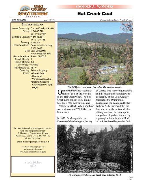
The BC Hydro compound lies below the excavation site.<br />
One of the thickest accumulations<br />
of coal in the world is<br />
in the <strong>Hat</strong> <strong>Creek</strong> Valley. The <strong>Hat</strong><br />
<strong>Creek</strong> <strong>Coal</strong> deposit is 26 kilometers<br />
long, 400 metres wide and<br />
1200 metres thick. When and how<br />
was it discovered? Well, therein<br />
lies a story.<br />
In 1877, Dr. George Mercer<br />
Dawson of the Geological Survey<br />
of Canada was surveying, mapping<br />
and discovering the geology and<br />
geography of the <strong>Gold</strong> <strong>Country</strong><br />
region for the Dominion of<br />
Canada and the Canadian Pacific<br />
Railway. As he surveyed the <strong>Hat</strong><br />
<strong>Creek</strong> area for the potential of a<br />
railway corridor, he came upon<br />
the graben. A graben, created by<br />
a geological fault, is a low block<br />
of rock bordered by parallel fault<br />
For more information or to report a problem<br />
with this site please contact:<br />
<strong>Gold</strong> <strong>Country</strong> Communities Society<br />
P.O. Box 933 Cache <strong>Creek</strong>, B.C. V0K 1H0<br />
Tel: 1-877-453-9467<br />
email: info@exploregoldcountry.com<br />
For more site pages go to:<br />
www.goldtrail.com or<br />
www.GeoTourismCanada.com<br />
Apply Sticker<br />
Here<br />
Photo: Royal BC Museum, BC Archives, n o F-02699<br />
40 foot prospect shaft, <strong>Hat</strong> <strong>Creek</strong> coal outcrop, 1910.<br />
107
80 foot deep coal outcrop at <strong>Hat</strong><br />
<strong>Creek</strong>, 1910<br />
scarps, or cliffs.<br />
Often referred<br />
to as a rift valley,<br />
visually you see a<br />
broad valley edged<br />
by broken rock<br />
formations. Little<br />
did Dawson know<br />
he had discovered<br />
one of the largest<br />
coal deposits in the<br />
world.<br />
At <strong>Hat</strong> <strong>Creek</strong> the<br />
coal is full range<br />
from bright to<br />
dull brown, but<br />
most of it is massive,<br />
compact,<br />
fine grained, relatively solid, dull brownish-black rock.<br />
Fragments of petrified wood are common in the coal.<br />
Parts of the coal are also characterized by small lenses,<br />
globules and irregular shaped masses of light-yellow,<br />
semi-transparent fossilized amber (retinite). Rare fossils<br />
of forest and insect specimens dating back 50 million<br />
years have been found in the amber.<br />
The area consists of Tertiary coal and classic sedimentary<br />
and volcanic formations that rest on Cretaceous<br />
volcanic rocks and metamorphosed Palaeozoic carbonates<br />
and greenstones.<br />
In 1893, rancher George Finney sank the first shaft to<br />
supply coal to locals and the village of Ashcroft. In 1923<br />
a Chinese syndicate began a more ambitious project to<br />
provide coal to the coast but it soon failed. The Clear<br />
Mountain <strong>Coal</strong> Company took over and was equally<br />
Photo: Royal BC Museum, BC Archives, n o G-08762<br />
unsuccessful. By 1925 it was <strong>Hat</strong> <strong>Creek</strong> <strong>Coal</strong> exploring<br />
with shafts, tunnels and drill holes, but again exploration<br />
soon became dormant that same year.<br />
Beginning in 1933 L.D. Leonard mined a few hundred<br />
tonnes of coal, until 1942 when all activity ceased due<br />
to World War II. In 1957 the <strong>Hat</strong> <strong>Creek</strong> coal area passed<br />
to B.C. Electric, now known as B.C. Hydro, and again<br />
further exploration and drilling ceased by 1959. In 1974<br />
B.C. Hydro resumed exploration of the site and began<br />
to mine sample quantities of coal. At this point protests<br />
began, continuing into the early 1980s and effectively<br />
preventing any further coal exploration or the development<br />
of a coal driven energy plant.<br />
The Ashcroft Museum boasts an exceptional display<br />
diarizing and documenting the history of coal discovery<br />
and exploration in the <strong>Hat</strong> <strong>Creek</strong> area. For more<br />
information or just to view the amazing stages in this<br />
story drop in for a walk through time. To this day there<br />
remains controversy and opposition to any further<br />
exploration and exploitation of one of the largest coal<br />
accumulations in the world, the coal at <strong>Hat</strong> <strong>Creek</strong> in the<br />
heart of <strong>Gold</strong> <strong>Country</strong>.<br />
Some interesting minerals present throughout the area<br />
include Bocanne, Buchite, Retinite and Poitevinite.<br />
Photo: Ashcroft Museum<br />
Photo: Ashcroft Museum<br />
Detailed access information:<br />
• From Cache <strong>Creek</strong>, follow Hwy #97N to Hwy #99.<br />
• Follow Hwy #99 west to <strong>Hat</strong> <strong>Creek</strong> Rd., on the left.<br />
• At Lehman Rd. keep left, remaining on <strong>Hat</strong><br />
<strong>Creek</strong> Rd.<br />
• Park well to the roadside to ensure adequate<br />
passing room.<br />
• NO trespassing on B.C. Hydro private property.<br />
Hamilton, W.R., Wooley, A.R., & Bishop, A.C. (1985). Larousse Guide to Minerals, Rocks and Fossils. 6th Edition. New<br />
York, USA: Larousse & Co.<br />
Press, F., & Siever, R. (1986). Earth. W.H. Freeman & Co.<br />
Bibliography & Sources<br />
108


