St. Mary's County Multi-Jurisdictional Hazard Mitigation Plan
St. Mary's County Multi-Jurisdictional Hazard Mitigation Plan
St. Mary's County Multi-Jurisdictional Hazard Mitigation Plan

Create successful ePaper yourself
Turn your PDF publications into a flip-book with our unique Google optimized e-Paper software.
Chapter 2: <strong>Hazard</strong> Identification<br />
SMC <strong>Multi</strong>-jurisdictional <strong>Hazard</strong> <strong>Mitigation</strong> <strong>Plan</strong><br />
The Special Flood <strong>Hazard</strong> Area (SFHA) is a convenient tool for assessing vulnerability and risk<br />
in flood-prone communities because many communities have maps available that show the<br />
extent of the base flood and likely depths that will be experienced. The base flood is often<br />
referred to as the “100-year flood” By lay persons and officially as the ” one percent annual<br />
chance flood.” Experiencing a 100-year flood does not<br />
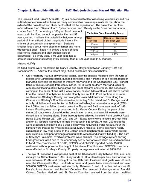
Table 4.8 - Flood Probability Terms<br />
mean a similar flood cannot happen for the next 99<br />
years; rather, it reflects the probability that, over a long Flood<br />
Chance of occurrence<br />
period of time, a flood of that magnitude have a 1% Recurrence in any given year<br />
chance of occurring in any given year. <strong>St</strong>atically<br />
10-year 10%<br />
smaller floods occur more often than larger and more<br />
50-year 2%<br />
widespread ones. Table 4.8 shows a range of flood<br />
100-year 1%<br />
recurrence intervals and their probabilities of<br />
500-year 0.20%<br />
occurrence. So every year, a 10-year flood has a<br />
greater likelihood of occurring (10% chance) than a 100-year flood (1% chance).<br />
Historic Activity<br />
25 flood events were reported in <strong>St</strong>. Mary’s <strong>County</strong>, Maryland between January 1994 and<br />
December 2010. A few of the recent major flood events are discussed below.<br />
• On 4 February 1998, a powerful nor'easter, carrying copious moisture from the Gulf of<br />
Mexico and Caribbean region, dumped between 2 and 4 inches of rain across much of<br />
Maryland between the foothills of western Maryland and the Chesapeake Bay. Highest<br />
totals of rainfall, ranging from 3 to 5 inches, fell in lower southern Maryland, causing<br />
widespread flooding of low lying areas and small streams and creeks. The nor’easter,<br />
coming on the heels of one just a week earlier, caused tides of 3 to 4 feet above normal<br />
from the Calvert <strong>County</strong>/Anne Arundel <strong>County</strong> line south to Point Lookout in extreme<br />
southeastern <strong>St</strong> Mary’s <strong>County</strong>; and along the lower tidal Potomac River along the<br />
Charles and <strong>St</strong> <strong>Mary's</strong> Counties shoreline, including Cobb Island and <strong>St</strong> George Island.<br />
A daily rainfall record was broken at Baltimore/Washington International Airport (BWI);<br />
the 1.65 inches that fell on the 4th broke the 78 year-old Baltimore area mark of 1.48<br />
inches. Flooding was most pronounced in <strong>St</strong>. <strong>Mary's</strong> <strong>County</strong>. During the peak of the<br />
storm, 26 roads were closed due the combination of wind and rain. Nine roads were<br />
closed due to flooding alone. <strong>St</strong>ate thoroughfares affected included Point Lookout Road<br />
(route 5),and Routes 237, 238, 243, and 271. Evacuations were initiated in Great Mills<br />
and on <strong>St</strong>. George Island due to rapid increases in tide levels. At least 200 residents<br />
were evacuated, including one 3 year-old boy who required a water rescue. Four fire<br />
fighters were treated for hypothermia at <strong>St</strong>. <strong>Mary's</strong> Hospital. Some cars were nearly<br />
submerged in low-lying areas. In the Golden Beach neighborhood, Lake White spilled<br />
over its banks, and poor drainage contributed to widespread shallow flooding . The dam<br />
at <strong>St</strong> <strong>Mary's</strong> Lake held; overflow problems were minimal. The sewage system serving<br />
Lexington Park failed due to the abnormally heavy flow of water which caused manholes<br />
to flood. The combination of BG&E, PEPCO, and SMECO reported nearly 15,000<br />
customers without power at the height of the storm. Four thousand SMECO customers<br />
were affected in <strong>St</strong>. <strong>Mary's</strong> <strong>County</strong>. Property damage was estimated at $650,000.<br />
• The eye of Hurricane Floyd passed east of the Chesapeake Bay between 9:00 a.m. and<br />
midnight on 16 September 1999. Gusty winds of 30 to 50 miles per hour blew across the<br />
area between 11 AM and midnight on the 16th, with localized wind gusts over 50 mph<br />
near the Chesapeake Bay. Hundreds of trees and power lines were downed and over<br />
500,000 SMECO customers lost electricity. Between 8 and 12 inches fell across <strong>St</strong>.<br />
<strong>Mary's</strong>, Anne Arundel, and Harford Counties. The amount of damage Anne Arundel,<br />
Calvert, Charles, Harford, and <strong>St</strong>. <strong>Mary's</strong> Counties received from the storm qualified<br />
35