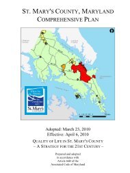
St. Mary's County Multi-Jurisdictional Hazard Mitigation Plan
St. Mary's County Multi-Jurisdictional Hazard Mitigation Plan
St. Mary's County Multi-Jurisdictional Hazard Mitigation Plan

You also want an ePaper? Increase the reach of your titles
YUMPU automatically turns print PDFs into web optimized ePapers that Google loves.
Chapter 2: <strong>Hazard</strong> Identification<br />
SMC <strong>Multi</strong>-jurisdictional <strong>Hazard</strong> <strong>Mitigation</strong> <strong>Plan</strong><br />
Wildfires and Urban Interface Fires<br />
Overview<br />
A wildfire is an uncontrolled fire spreading through vegetative fuels, such as brush, marshes,<br />
grasslands, or field lands, exposing and possibly consuming structures. They often begin<br />
unnoticed and spread quickly and are usually signaled by dense smoke that fills the area for<br />
miles around. Wildfires may also be called forest fires. For the purpose of this analysis, the<br />
term wildfire will be used. The causes of these fires include lightning, human carelessness, and<br />
arson.<br />
An urban-wildland<br />
interface fire is a<br />
wildfire in a<br />
geographical area<br />
where structures and<br />
other human<br />
development meet or<br />
intermingle with<br />
wildland or vegetative<br />
fuels. Fires can be<br />
rated based on their<br />
degree of combustion<br />
as noted in Table 4.10.<br />
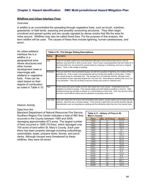
Table 4.10 - Fire Danger Rating Descriptions<br />
Rating<br />
Low<br />
Moderate<br />
High<br />
Description<br />
Fuels do not ignite readily from small firebrands although a more intense heat source, such as<br />
lightning, may start fires in duff or punky wood. Fires in open cured grasslands may burn freely for a<br />
few hours after rain, but woods fires spread slowly by creeping or smoldering, and burn in irregular<br />
fingers. There is little danger of spotting.<br />
Fires can start from most accidental causes, but with the exception of lightning, the number of fires is<br />
generally low. Fires in open cured grasslands will burn briskly and rapidly on windy days. Timber<br />
fires spread slowly to moderately fast. The average fire is of moderate intensity, although heavy<br />
concentrations of fuel, especially draped fuel, may burn hot. Short-distance spotting may occur, but<br />
is not persistent. Fires are not likely to become serious and control is relatively easy.<br />
All fine dead fuels ignite readily and fires start easily from most causes. Unattended brush and<br />
campfires are likely to escape. Fires spread rapidly and short-distance spotting is common. Highintensity<br />
burning may develop on slopes or in concentrations of fine fuels. Fires may become serious<br />
and their control difficult unless they are attacked successfully while small.<br />
Historic Activity<br />
Very High<br />
Data from the<br />
Maryland Department of Natural Resources Fire Service,<br />
Southern Region Fire Center indicates a total of 982 fires<br />
occurred in the <strong>County</strong> between 1985 and 2009,<br />
damaging approximately 873 acres. The largest number<br />
of fires occurred in 1995 (79 fires), which damaged over<br />
100 acres of land within <strong>St</strong>. Mary’s <strong>County</strong>. Each year<br />
there has been property damage including outbuildings,<br />
automobiles, boats, propane tanks, fences, and porch<br />
decks. Although houses were threatened by these<br />
wildfires, they were all saved.<br />
Fires start easily from all causes and immediately after ignition, spread rapidly and increase quickly in<br />
intensity. Spot fires are a constant danger. Fires burning in light fuels may quickly develop intensity<br />
characteristics such as long-distance spotting and fire whirlwinds when they burn into heavier fuels.<br />
Table 4.11 - History of Fires in <strong>St</strong>.<br />
Mary’s <strong>County</strong><br />
Year No. of Fires Acres<br />
1990 11 11.3<br />
1991 45 59.9<br />
1992 64 34.2<br />
1993 35 19.5<br />
1994 45 72<br />
1995 79 104.1<br />
1996 22 10.2<br />
1997 35 21.8<br />
1998 40 30.9<br />
1999 61 52.8<br />
2000 17 10.6<br />
2001 59 40.4<br />
2002 57 32.8<br />
2003 9 4.5<br />
2004 23 23.8<br />
2005 25 9.9<br />
2006 55 12.7<br />
2007 71 66.7<br />
2008 36 12.8<br />
2009 35 18.5<br />
41