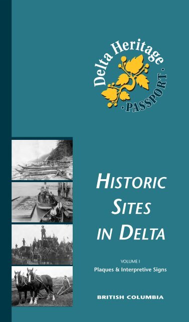
HISTORIC SITES IN DELTA DeltaHeritage - The Corporation of Delta
HISTORIC SITES IN DELTA DeltaHeritage - The Corporation of Delta
HISTORIC SITES IN DELTA DeltaHeritage - The Corporation of Delta

Create successful ePaper yourself
Turn your PDF publications into a flip-book with our unique Google optimized e-Paper software.
<strong>Delta</strong> Heritage<br />
•<br />
• PA S S P O R T<br />
<strong>HISTORIC</strong><br />
<strong>SITES</strong><br />
<strong>IN</strong> <strong>DELTA</strong><br />
VOLUME I<br />
Plaques & Interpretive Signs<br />
BRITISH COLUMBIA
It is with great pleasure that<br />
the <strong>Delta</strong> Heritage Advisory<br />
Commission publishes its first<br />
in a series <strong>of</strong> “passports” to<br />
<strong>Delta</strong>’s <strong>of</strong>ficial Historic Sites.<br />
We invite you to join us in<br />
celebrating the rich and<br />
varied history <strong>of</strong> our<br />
community, a history<br />
reaching back to the earliest<br />
days <strong>of</strong> British Columbia and<br />
one we share with our<br />
neighbours, the Tsawwassen<br />
First Nation.<br />
We hope that whether you<br />
are a resident or visitor to<br />
<strong>Delta</strong> you will enjoy your<br />
journey to the markers <strong>of</strong><br />
<strong>Delta</strong>'s remarkable story.<br />
<strong>The</strong> Big Store, <strong>Delta</strong> Street<br />
Ladner, 1920<br />
TABLE OF CONTENTS<br />
1 Annieville<br />
2 Annieville Cannery<br />
3 Sunbury<br />
4 Kennedy Trail<br />
5 Mackie Park<br />
6 St. Stephen’s Church<br />
7 Butler’s Corner<br />
8 East <strong>Delta</strong> Oyster Plant<br />
9 St. David’s Anglican Church<br />
10 Early First Nation Settlement<br />
11 Tsawwassen First Nation<br />
12 Harbour Park & Swensen Trail<br />
13 Port Guichon<br />
14 Homer Stevens Park<br />
15 Westham Island<br />
16 Ladner Chinatown<br />
17 Ladner’s Landing<br />
18 W.H. Ladner House<br />
19 Kirkland Park<br />
<strong>Delta</strong> Heritage<br />
•<br />
• PA S S P O R T<br />
Cover photos:<br />
• "Goodfellows" fishing camp on Boundary Bay, ca. 1895<br />
• Unloading fish at the <strong>Delta</strong> Cannery, ca. 1880<br />
• Hauling shingle blocks to Thompson Mill, North <strong>Delta</strong>, ca. 1910<br />
• <strong>Delta</strong> farmers plowing match, 1928
<strong>Delta</strong> Heritage<br />
•<br />
• PA S S P O R T<br />
Annieville<br />
1<br />
Dedication <strong>of</strong> original church on<br />
Norum Point, 1905<br />
Trinity Lutheran Church<br />
NORTH<br />
River Road<br />
Norum Rd<br />
90 Ave<br />
92A Ave<br />
Park Rd<br />
91 Ave<br />
90 Ave<br />
11040 River Road, <strong>Delta</strong>, BC<br />
Trinity Lutheran Church,<br />
dedicated May 22, 1910,<br />
overlooks the historic fishing<br />
village <strong>of</strong> Annieville. Part <strong>of</strong> the<br />
message placed in the corner<br />
stone reads: “Remember the<br />
promise you gave on the day <strong>of</strong><br />
your Confirmation, back home<br />
in the unforgettable Norway.”<br />
This building became the new<br />
home for the congregation after<br />
the church at Norum Point was<br />
demolished, making way for the<br />
new Great Northern Railway<br />
(GNR).<br />
<strong>HISTORIC</strong> <strong>SITES</strong> <strong>IN</strong> <strong>DELTA</strong>
2<br />
Annieville<br />
Cannery<br />
<strong>The</strong> Annieville fishing camp sign<br />
marks the site <strong>of</strong> Peter Birrell’s<br />
cannery, which he built in the<br />
1890s. Annieville Cannery<br />
operated into the 1940s. <strong>The</strong><br />
above photo was taken circa<br />
1905, a few years before the<br />
Great Nothern Railway (GNR)<br />
was built through Annieville on<br />
the old River Road grade.<br />
Gunderson Slough formed later,<br />
as a result <strong>of</strong> growing industrial<br />
activity along the river.<br />
F r a s e<br />
i v e r<br />
r R<br />
Alaska Way<br />
Gunderson Slough<br />
Annieville Cannery, ca. 1905<br />
Gunderson Rd<br />
River Road<br />
Gunderson Road, <strong>Delta</strong>, BC<br />
SURREY<br />
<strong>DELTA</strong><br />
NORTH<br />
<strong>HISTORIC</strong> <strong>SITES</strong> <strong>IN</strong> <strong>DELTA</strong>
<strong>Delta</strong> Heritage<br />
•<br />
• PA S S P O R T<br />
Sunbury<br />
3<br />
Ms. Rita Hayman’s<br />
Sunbury school class, 1936<br />
Alex Fraser Bridge<br />
NORTH<br />
River Road<br />
Centre St<br />
Sheaves Rd<br />
Main St<br />
Dunlop Rd<br />
Nordel Way<br />
10409 Dunlop Road, <strong>Delta</strong>, BC<br />
Sunbury, before World War II,<br />
was a mixed ethnic<br />
neighbourhood <strong>of</strong> largely<br />
Japanese and Scandinavian<br />
fishermen living along River Road<br />
between North <strong>Delta</strong> Heights<br />
and Tilbury Island. <strong>The</strong> Glenrose<br />
and St. Mungo Canneries were<br />
major employers. <strong>The</strong> plaque is<br />
located at Sunbury Hall, which<br />
was originally located on Centre<br />
Street at River Road.<br />
<strong>HISTORIC</strong> <strong>SITES</strong> <strong>IN</strong> <strong>DELTA</strong>
113A St<br />
4 Kennedy Trail<br />
James and Caroline Kennedy, 1854<br />
James Kennedy cut the<br />
settlement trail in 1861 from<br />
the Brownsville Wharf on the<br />
Fraser River to pasture land at<br />
Mud Bay. <strong>The</strong> contract for the<br />
14.5 km (9 mi) road specified<br />
that it be 3 m (10 ft) wide, “all<br />
stumps to be grubbed out or<br />
cut down level with the ground<br />
surface”, marshy spots<br />
corduroyed and bridges “to be<br />
<strong>of</strong> round poles”. Imagine<br />
standing at this site when it was<br />
a tall, thick forest <strong>of</strong> Douglas Fir,<br />
Spruce and Hemlock and facing<br />
this task with only hand saws<br />
and axes!<br />
92A Ave<br />
114 St<br />
91 Ave<br />
Cres<br />
Pemberto n<br />
92 Ave<br />
89A Ave<br />
116 St<br />
90 Ave<br />
Gibson Elementary School<br />
11451 - 90 Ave, <strong>Delta</strong>, BC<br />
NORTH<br />
<strong>HISTORIC</strong> <strong>SITES</strong> <strong>IN</strong> <strong>DELTA</strong>
<strong>Delta</strong> Heritage<br />
•<br />
• PA S S P O R T<br />
Mackie Park<br />
5<br />
Interpretive sign at Machie Park<br />
NORTH<br />
Wadham<br />
108 St<br />
Dr<br />
109B St<br />
110 St<br />
82 Ave<br />
80 Ave<br />
79A Ave<br />
110 St<br />
10900 - 82 Ave, <strong>Delta</strong>, BC<br />
<strong>HISTORIC</strong> <strong>SITES</strong> <strong>IN</strong> <strong>DELTA</strong><br />
Mackie Park heralds the<br />
accomplishments <strong>of</strong> one <strong>of</strong><br />
North <strong>Delta</strong>’s pioneer families.<br />
<strong>The</strong> sign at the park tells the<br />
story <strong>of</strong> George Mackie, Sr. who<br />
arrived in British Columbia in<br />
1888 and found work in sawmills<br />
and fishing. Like many early<br />
immigrants, George saw<br />
opportunity in his adopted land.<br />
His vision <strong>of</strong> “Steel City”, a<br />
planned industrial town in the<br />
Sunbury area, was a grand<br />
scheme that was never realized.<br />
<strong>The</strong> Mackie family, however,<br />
would go on to create other<br />
successes in <strong>Delta</strong>.
6<br />
St. Stephen’s<br />
Church<br />
<strong>The</strong> plaque salutes<br />
the enterprise <strong>of</strong><br />
the people <strong>of</strong> East<br />
<strong>Delta</strong>. <strong>The</strong>y provided their<br />
community with services centred<br />
in this area, among them St.<br />
Stephen’s Church (1891), East<br />
<strong>Delta</strong> School (1888), and East<br />
<strong>Delta</strong> Community Hall (1930).<br />
<strong>The</strong> East <strong>Delta</strong> farmers also built<br />
the first municipal dyke on<br />
Boundary Bay in 1892.<br />
Burns Dr<br />
Trunk Road streetscape, ca. 1935<br />
Ladner Trunk Rd<br />
96 St<br />
10<br />
99<br />
Hornby Dr<br />
NORTH<br />
9696 Ladner Trunk Road, <strong>Delta</strong>, BC<br />
<strong>HISTORIC</strong> <strong>SITES</strong> <strong>IN</strong> <strong>DELTA</strong>
<strong>Delta</strong> Heritage<br />
•<br />
• PA S S P O R T<br />
Butler’s Corner<br />
7<br />
Photos <strong>of</strong> Butler’s Store, ca. 1925<br />
Burns Dr<br />
NORTH<br />
10<br />
96 St 96 St<br />
Ladner Trunk Rd<br />
99<br />
Hornby Dr<br />
9581 Ladner Trunk Road, <strong>Delta</strong>, BC<br />
<strong>The</strong> tiny village <strong>of</strong> East <strong>Delta</strong>,<br />
consisting <strong>of</strong> a store, a<br />
blacksmith shop and several<br />
small residential lots, formed in<br />
1911 at the crossroads <strong>of</strong> Ladner<br />
Trunk Road and Mathews Road<br />
(96 th Street). <strong>The</strong> village grew<br />
around the existing East <strong>Delta</strong><br />
School and St. Stephen’s<br />
Church. Butler’s Store and gas<br />
station saved the local farmers<br />
a long, bumpy and usually<br />
muddy drive into Ladner.<br />
<strong>HISTORIC</strong> <strong>SITES</strong> <strong>IN</strong> <strong>DELTA</strong>
8<br />
East <strong>Delta</strong><br />
Oyster Plant<br />
Commercial oyster operations<br />
in B.C. began in Boundary Bay<br />
at Blackie Spit in 1904 and<br />
continued for nearly 60 years.<br />
Standing at this spot in the<br />
1950s, you could watch John<br />
Christopherson’s tug boat tow<br />
a barge full <strong>of</strong> freshly picked<br />
oysters to the B.C. Packer’s<br />
plant for shucking.<br />
Between 1940 and 1963,<br />
50% <strong>of</strong> the provincial<br />
production <strong>of</strong> oysters<br />
came from Boundary<br />
Bay until water pollution<br />
forced the closure <strong>of</strong> this unique<br />
local industry.<br />
Sikh workers at the B.C. Packer’s Oyster Plant, ca. 1950<br />
99<br />
Hornby Dr<br />
Dyke<br />
Trail<br />
B o u n d a<br />
112 St<br />
r y<br />
B a y<br />
NORTH<br />
South end <strong>of</strong> 112 St,<br />
at dyke<br />
<strong>HISTORIC</strong> <strong>SITES</strong> <strong>IN</strong> <strong>DELTA</strong>
<strong>Delta</strong> Heritage<br />
•<br />
• PA S S P O R T<br />
St. David’s<br />
Anglican Church<br />
9<br />
53A St<br />
NORTH<br />
54 St<br />
8A Ave<br />
Winskill<br />
Park<br />
8B Ave<br />
Gilchrist Dr<br />
9 Ave<br />
55A St<br />
5575 - 9 Ave, <strong>Delta</strong>, BC<br />
56 St<br />
<strong>The</strong> first Anglican service in<br />
Boundary Bay was held in<br />
the local school in 1908, with<br />
a congregation <strong>of</strong> 48. Boundary<br />
Bay remained part <strong>of</strong> All Saints<br />
Parish until 1956. <strong>The</strong> growing<br />
congregation built their own<br />
church between 1953 and<br />
1955 on the corner <strong>of</strong> 56 th<br />
Street and 12 th Avenue. In 1970<br />
the congregation moved to a<br />
larger church, and the old<br />
building was adapted for<br />
recreational use as part <strong>of</strong> the<br />
Winskill Aquatic and Leisure<br />
Centre in Winskill Park.<br />
<strong>HISTORIC</strong> <strong>SITES</strong> <strong>IN</strong> <strong>DELTA</strong>
10<br />
Early First Nation<br />
Settlement<br />
16 Ave<br />
56 St<br />
<strong>The</strong> plaque marks the southern<br />
end <strong>of</strong> an aboriginal village built<br />
on an ancient beach above<br />
Boundary Bay. Sixty years ago<br />
you could still see the middens<br />
left by their activities. (<strong>The</strong> air<br />
photo above shows the midden<br />
area along 56 th Street and 16 th<br />
Avenue in 1957). Urban growth<br />
has largely destroyed this<br />
important archaeological<br />
site.<br />
55A St<br />
14B Ave<br />
56 St<br />
View Cres<br />
16 Ave<br />
Village Greens Wynd<br />
NORTH<br />
View Crescent,<br />
<strong>Delta</strong>, BC<br />
Ceremonial stone bowl,<br />
2000-3000 years old<br />
<strong>HISTORIC</strong> <strong>SITES</strong> <strong>IN</strong> <strong>DELTA</strong>
<strong>Delta</strong> Heritage<br />
•<br />
• PA S S P O R T<br />
Tsawwassen<br />
First Nation<br />
11<br />
Church <strong>of</strong> the Holy Ghost<br />
B a<br />
t s<br />
R o b e r<br />
NORTH<br />
k<br />
n<br />
Rd North<br />
Tsawwassen<br />
146 Tsawwassen<br />
Drive North,<br />
<strong>Delta</strong>, BC<br />
Eagle Way<br />
17<br />
Church <strong>of</strong> the Holy Ghost, ca. 1930<br />
<strong>The</strong> Tsawwassen First Nation<br />
Reserve was created at the<br />
winter village site <strong>of</strong> this Coast<br />
Salish tribe. Cut <strong>of</strong>f from their<br />
traditional territory, the<br />
Tsawwassen people found it<br />
difficult to sustain themselves<br />
with traditional hunting, fishing<br />
and gathering. <strong>The</strong><br />
village longhouse,<br />
the centre <strong>of</strong><br />
cultural activity,<br />
was destroyed<br />
when Highway<br />
No. 17 was built.<br />
<strong>HISTORIC</strong> <strong>SITES</strong> <strong>IN</strong> <strong>DELTA</strong>
12<br />
Harbour Park<br />
& Swensen Trail<br />
Ladner Harbour Park was Art<br />
Swensen’s dream. In 1958 he<br />
envisioned a family park on the<br />
island opposite downtown<br />
Ladner. Art served three terms<br />
as Chair <strong>of</strong> the <strong>Delta</strong> Centennial<br />
Committee and, in 1971, finally<br />
convinced the committee to<br />
support the development <strong>of</strong><br />
the park. Ladner Harbour Park<br />
is located on old dredging<br />
spoils. Art Swenson took<br />
pleasure in noting that<br />
“every time the river<br />
channel is dredged the<br />
park gets bigger.”<br />
R e a c h<br />
L a d n e r s<br />
Swensen<br />
Arthur Swensen, ca. 1967<br />
Trail<br />
Ladner<br />
Harbour<br />
Park<br />
L a d n e r s H a r b o u r<br />
48 Ave<br />
McNeely’sWay<br />
<strong>Delta</strong> St<br />
47A Ave<br />
River Road<br />
Elliott St<br />
NORTH<br />
Ladner Harbour Park,<br />
McNeely’s Way,<br />
<strong>Delta</strong>, BC<br />
<strong>HISTORIC</strong> <strong>SITES</strong> <strong>IN</strong> <strong>DELTA</strong>
<strong>Delta</strong> Heritage<br />
•<br />
• PA S S P O R T<br />
Port Guichon<br />
13<br />
Port Guichon, ca. 1903<br />
L<br />
NORTH<br />
a d<br />
n e<br />
r s R e<br />
41B St<br />
River Rd West<br />
Church St<br />
44B Ave<br />
Plaque located on wall <strong>of</strong> Pump Station,<br />
4200 Block River Rd West, <strong>Delta</strong>, BC<br />
a<br />
c<br />
h<br />
When the railroad reached Port<br />
Guichon in 1903, the town<br />
eclipsed Ladner as <strong>Delta</strong>’s<br />
transportation centre. Originally<br />
the train stopped on the wharf<br />
to meet steamships from<br />
Victoria. In 1924, the train<br />
station was moved to nearby<br />
Savoy Street. <strong>The</strong> train<br />
continued to serve Port<br />
Guichon’s sawmill, hotel, farms<br />
and canneries into the 1930s.<br />
<strong>HISTORIC</strong> <strong>SITES</strong> <strong>IN</strong> <strong>DELTA</strong>
14<br />
Homer Stevens<br />
Park<br />
Members <strong>of</strong> the Martinolich, Bussanich &<br />
Radoslovich families, boat building and fishing<br />
families <strong>of</strong> Port Guichon, ca. 1913<br />
This modest park complements<br />
the distinct character <strong>of</strong> the Port<br />
Guichon neighborhood in which<br />
Homer Stevens grew up. Homer,<br />
and his father Nick Stevens,<br />
championed the rights <strong>of</strong><br />
working people and the union<br />
movement that gave voice to<br />
their aspirations. Commercial<br />
fishing continues to this day<br />
along the dyke opposite the<br />
park. Visitors can still see the<br />
remnants <strong>of</strong> the original fishing<br />
wharves and net l<strong>of</strong>ts that<br />
belonged to the fishing and boat<br />
building families <strong>of</strong> Port<br />
Guichon.<br />
L a d n<br />
Church St<br />
Weare St<br />
44B Ave<br />
e r s R e a<br />
River Road West<br />
Savoy St<br />
c h<br />
Station St<br />
45 St<br />
Stevens Park,<br />
4440 River Rd West, <strong>Delta</strong>, BC<br />
NORTH<br />
<strong>HISTORIC</strong> <strong>SITES</strong> <strong>IN</strong> <strong>DELTA</strong>
<strong>Delta</strong> Heritage<br />
•<br />
• PA S S P O R T<br />
Westham Island<br />
15<br />
Ca. 1914<br />
Westham Is Rd<br />
NORTH<br />
Rd<br />
Trim<br />
e<br />
C a n o<br />
Bridge<br />
s s<br />
P a<br />
River Rd West<br />
Kettle Rd<br />
3317 Westham Island Road, <strong>Delta</strong>, BC<br />
Ever since the first farmers and<br />
fisher folk settled here in the<br />
1870s, Westham Island residents<br />
have maintained pride in their<br />
separate identity. Officially<br />
opened in March 1910 with a<br />
lavish banquet, the Westham<br />
Island Bridge ended the<br />
residents’ isolation. Today,<br />
visitors still cross this bridge to<br />
see the Reifel Bird Sanctuary<br />
and to buy produce from the<br />
local farms.<br />
<strong>HISTORIC</strong> <strong>SITES</strong> <strong>IN</strong> <strong>DELTA</strong>
16<br />
Ladner<br />
Chinatown<br />
Urban growth has completely<br />
altered the landscape at the west<br />
end <strong>of</strong> 48 th Avenue (Westham<br />
Street). It would be impossible,<br />
without photographs and old<br />
maps, to tell that Ladner’s once<br />
thriving Chinatown lined the<br />
dyke here in the late 1800s. After<br />
much <strong>of</strong> Chinatown burned in<br />
1929, Chung Chuck<br />
bought land inside the<br />
dyke for his potato field.<br />
<strong>The</strong> field and dyke are<br />
now covered by a<br />
condominium and<br />
marina complex.<br />
Harbour Walk<br />
Ladner Chinatown, ca. 1955<br />
L a d n e r<br />
47A St<br />
Chung Chuck’s store, ca. 1950<br />
r<br />
H a r b o u<br />
48 Ave<br />
47A Ave<br />
47 Ave<br />
Georgia St<br />
48B St<br />
NORTH<br />
Pathway to<br />
water from<br />
48 Ave/47A St<br />
<strong>HISTORIC</strong> <strong>SITES</strong> <strong>IN</strong> <strong>DELTA</strong>
Ladner’s Landing, ca. 1900<br />
Ladner Harbour<br />
NORTH<br />
Chisholm St<br />
Georgia St<br />
Southwest<br />
corner <strong>of</strong><br />
Chisholm St<br />
and Elliot St<br />
• PA S S P O R T<br />
<strong>Delta</strong> St<br />
<strong>HISTORIC</strong> <strong>SITES</strong> <strong>IN</strong> <strong>DELTA</strong><br />
•<br />
Trennant<br />
Bridge St<br />
River Road<br />
48 Ave<br />
<strong>Delta</strong> Hotel, ca. 1913<strong>Delta</strong> Heritage<br />
Westminster Ave<br />
Elliott St<br />
Ladner’s Landing<br />
17<br />
<strong>The</strong> plaque and sign are on the<br />
site <strong>of</strong> the former <strong>Delta</strong> Hotel.<br />
<strong>The</strong> <strong>Delta</strong> Hotel greeted visitors,<br />
salesmen and new settlers<br />
disembarking at Ladner’s wharf<br />
from the 1880s until 1923, when<br />
the hotel burned down. <strong>The</strong><br />
wharf was built in 1875 and this<br />
post <strong>of</strong>fice stop became<br />
a town in the 1880s<br />
when Donald<br />
Chisholm purchased<br />
and surveyed the<br />
site. <strong>The</strong> street still<br />
carries the<br />
Chisholm name.
18<br />
W.H. Ladner<br />
House<br />
<strong>The</strong> plaque tells us that we should<br />
see a house in front <strong>of</strong> us;<br />
however, the plaque was erected<br />
one year before the historic<br />
William Ladner house burned<br />
down, likely the result <strong>of</strong> arson.<br />
<strong>The</strong> house, Ladner’s third home,<br />
was built in 1882. Paul Ladner,<br />
his son, planted an orchard <strong>of</strong><br />
pear and holly trees on the farm<br />
surrounding the home. We enjoy<br />
these same trees to this day.<br />
48 Ave<br />
47A Ave<br />
47 Ave<br />
Garry St<br />
W.H. Ladner House, ca. 1925<br />
Elliott<br />
51 St<br />
45 Ave<br />
44 Ave<br />
Arthur Drive<br />
4661 - 51 Street, <strong>Delta</strong>, BC<br />
Chilukthan<br />
Slough<br />
NORTH<br />
<strong>HISTORIC</strong> <strong>SITES</strong> <strong>IN</strong> <strong>DELTA</strong>
<strong>Delta</strong> Heritage<br />
•<br />
• PA S S P O R T<br />
Kirkland Park<br />
19<br />
Kirkland House, ca. 1912<br />
Whitworth Cres<br />
NORTH<br />
Arthur Drive<br />
Chilukthan Slough<br />
44 Ave<br />
4026 Arthur Drive, <strong>Delta</strong>, BC<br />
<strong>The</strong> Kirkland family were<br />
early pioneers in <strong>Delta</strong> and were<br />
active in the economic, social and<br />
political life <strong>of</strong> the municipality<br />
as early as the 1870s. This large<br />
family home was constructed in<br />
1911 for William and Edna<br />
Kirkland and their six children on<br />
their farm called Hawthorne<br />
Grove. Volunteers <strong>of</strong> the Kirkland<br />
House Foundation are restoring<br />
it for public use.<br />
<strong>HISTORIC</strong> <strong>SITES</strong> <strong>IN</strong> <strong>DELTA</strong>
• PA S S P O R T<br />
Ladner baseball team, 1926<br />
Notes<br />
<strong>Delta</strong> Heritage<br />
•<br />
<strong>HISTORIC</strong> <strong>SITES</strong> <strong>IN</strong> <strong>DELTA</strong>
o<br />
r<br />
34 ST<br />
52 ST<br />
56 ST<br />
56 ST<br />
64 ST<br />
at pleasure that<br />
ritage Advisory<br />
publishes Each its first site identified in this passport is marked with<br />
“passports” to<br />
a plaque or sign. <strong>The</strong> <strong>Delta</strong> Heritage Advisory<br />
al Historic Sites.<br />
Commission invites you to visit each location and<br />
to join learn us in why it is historically significant to <strong>Delta</strong>.<br />
he rich and<br />
y <strong>of</strong> our<br />
a history<br />
1 Annieville<br />
TABLE OF CONTENTS<br />
k to the earliest<br />
h Columbia and<br />
2 Annieville Cannery<br />
with our 1 Annieville 3 Sunbury<br />
the Tsawwassen 2 Annieville Cannery<br />
4 Kennedy Trail<br />
3 Sunbury<br />
t whether you<br />
4 Kennedy 5 Mackie Trail Park<br />
t or visitor to 5 Mackie Park<br />
6 St. Stephen’s Church<br />
ll enjoy your 6 St. Stephen’s Church<br />
e markers <strong>of</strong> 7 Butler’s 7 Corner Butler’s Corner<br />
rkable story. 8 East <strong>Delta</strong> 8 East Oyster <strong>Delta</strong> Plant Oyster Plant<br />
9 St. David’s Anglican Church<br />
10<br />
9 St. David’s Anglican Church<br />
Early First Nation Settlement<br />
11 Tsawwassen 10 Early First Nation Settlement<br />
12 Harbour Park & Swensen Trail<br />
11 Tsawwassen First Nation<br />
13 Port Guichon<br />
14 Homer 12 Stevens Harbour Park & Swenson Trail<br />
<strong>Delta</strong> Street<br />
15 Westham 13 Port Island Guichon<br />
16 Ladner Chinatown<br />
17<br />
14<br />
Ladner’s<br />
Homer Stevens Park<br />
Landing<br />
18 W.H. 15 Ladner Westham House Island<br />
19 Kirkland Park<br />
16 Ladner Chinatown<br />
ritage<br />
A S S P O R T<br />
Using this Passport<br />
•<br />
17 Ladner’s Landing<br />
<strong>Delta</strong> Street, Ladner<br />
ca. 1912<br />
Cover photos:<br />
18 W.H. Ladner House<br />
• "Goodfellows" fishing camp on Boundary Bay, ca. 1895<br />
• Unloading fish at the <strong>Delta</strong> Cannery, ca. 1880<br />
• Hauling shingle blocks 19 to Kirkland Thompson Park Mill, North <strong>Delta</strong>, ca. 1910<br />
• <strong>Delta</strong> farmers plowing match, 1928<br />
S t r a i t<br />
G<br />
e<br />
g<br />
NORTH<br />
RICHMOND<br />
<strong>DELTA</strong><br />
REIFEL<br />
BIRD<br />
SANCTUARY<br />
o<br />
f<br />
i<br />
a<br />
<strong>Delta</strong> Heritage<br />
R o<br />
ROBERTSON<br />
S o u<br />
t h<br />
Westham<br />
Island<br />
b e<br />
C a<br />
r t<br />
PORT OF<br />
VANCOUVER<br />
n o<br />
s<br />
e<br />
•<br />
• PA S S P O R T<br />
B a<br />
A r m<br />
WESTHAM IS ROAD<br />
P a<br />
n<br />
s<br />
k<br />
s<br />
RIVER<br />
BC FERRIES<br />
TSAWWASSEN<br />
TERM<strong>IN</strong>AL<br />
o f F r<br />
15<br />
ROAD WEST<br />
a s<br />
33A AVE<br />
e r<br />
R i v<br />
e r<br />
47A AVE<br />
DRIVE<br />
ARTHUR<br />
<strong>DELTA</strong>PORT WAY<br />
12 AVE<br />
Deas<br />
Island<br />
Ladner<br />
BRITISH COLUMBIA<br />
WASH<strong>IN</strong>GTON PO<strong>IN</strong>T ROBERTS, USA<br />
13<br />
14<br />
41B ST<br />
16<br />
46A ST<br />
12<br />
18<br />
11<br />
ENGLISH BLUFF<br />
99<br />
FERRY RD<br />
6 AVE<br />
TUNNEL<br />
17<br />
M<br />
16 AVE<br />
1 AVE<br />
9<br />
RIVER RD<br />
19<br />
34B AVE<br />
28 AVE<br />
10<br />
BOUNDARY<br />
17<br />
BAY<br />
99<br />
10<br />
72 ST<br />
Tsawwassen<br />
RD<br />
Key<br />
M<br />
17<br />
36 AVE<br />
3 AVE<br />
RIVER<br />
<strong>Delta</strong> Museum<br />
and Archives<br />
Historic Site<br />
ROAD<br />
Tilbury<br />
Island<br />
B<br />
BOUNDARY<br />
BAY<br />
AIRPORT<br />
o u<br />
BURNS BOG<br />
n d<br />
BURNS DR<br />
a r<br />
7<br />
y<br />
96 ST<br />
Annacis<br />
Island<br />
6<br />
<strong>DELTA</strong><br />
AIR<br />
PARK<br />
3<br />
North<br />
<strong>Delta</strong><br />
104 ST<br />
B a<br />
91<br />
64 AVE<br />
99<br />
RIVER<br />
y<br />
108 ST<br />
1<br />
10<br />
RD<br />
NORDEL WAY<br />
5<br />
112 ST<br />
2<br />
SURREY<br />
116 ST<br />
80 AVE<br />
72 AVE<br />
96 AVE<br />
LYON RD<br />
90 AVE<br />
84 AVE<br />
KITTSON PKWY<br />
8<br />
4<br />
<strong>DELTA</strong><br />
SCOTT ROAD<br />
120 ST<br />
SCOTT ROAD<br />
SURREY<br />
John Oliver Farmhouse, 1902
<strong>Delta</strong> Heritage<br />
•<br />
• PA S S P O R T<br />
VOLUME I<br />
Plaques & Interpretive Signs<br />
For further information<br />
please contact the<br />
Community Planning &<br />
Development Department<br />
<strong>The</strong> <strong>Corporation</strong> <strong>of</strong> <strong>Delta</strong><br />
4500 Clarence Taylor Cres<br />
<strong>Delta</strong>, British Columbia<br />
V4K 3E2<br />
<strong>Delta</strong> Municipal Hall<br />
(<strong>Delta</strong> Museum and Archives after 1969)<br />
ca. 1914<br />
<strong>Delta</strong> Museum and Archives<br />
4858 <strong>Delta</strong> Street<br />
<strong>Delta</strong>, British Columbia<br />
V4K 2T8<br />
TELEPHONE<br />
604.946.3380<br />
FAX<br />
604.946.4148<br />
EMAIL<br />
heritage@corp.delta.bc.ca<br />
WEB<br />
www.corp.delta.bc.ca<br />
TELEPHONE<br />
604.946.9322<br />
Photos courtesy <strong>of</strong> the<br />
<strong>Delta</strong> Museum & Archives