Navigation Log and Flight Plan - OU Aviation
Navigation Log and Flight Plan - OU Aviation
Navigation Log and Flight Plan - OU Aviation

You also want an ePaper? Increase the reach of your titles
YUMPU automatically turns print PDFs into web optimized ePapers that Google loves.
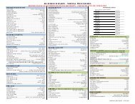
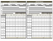
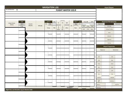
NAVIGATION LOG<br />
Aircraft Number N FLIGHT WATCH 122.0<br />
Airport Diagram<br />
Check Points<br />
(Fixes)<br />
VOR<br />
Wind CAS<br />
Dist. GS Time Off GPH Airport & ATIS Advisories<br />
TC TH MH<br />
Ident Course<br />
Dir. Vel. Leg Est. Departure Destination<br />
Freq.<br />
(Route) Altitude<br />
-L -E<br />
CH<br />
ETE ETA Fuel ATIS Code<br />
Temp TAS +R +W ±Dev. Rem. Act<br />
WCA Var.<br />
ATE ATA Rem. Ceiling & Visibility<br />
Wind<br />
Altimeter<br />
Approach<br />
Runway<br />
Airport Frequencies<br />
Departure<br />
Destination<br />
ATIS<br />
ATIS<br />
Grnd<br />
Apch<br />
Tower<br />
Tower<br />
Dep.<br />
Grnd<br />
CTAF<br />
CTAF<br />
FSS<br />
FSS<br />
UNICOM<br />
UNICOM<br />
Field<br />
Elev.<br />
Field Elev.<br />
Block In<br />
<strong>Log</strong> Time<br />
<strong>Flight</strong> <strong>Plan</strong> <strong>and</strong> Weather <strong>Log</strong> on Reverse Side<br />
TOTALS <br />
Block Out
Ceiling, Visibility, <strong>and</strong> Precipitation<br />
Reported<br />
Forecast<br />
WEATHER LOG<br />
Winds Aloft Icing <strong>and</strong> Freezing Level Turbulence <strong>and</strong> Cloud Tops<br />
Position <strong>and</strong> Fronts, Lows,<br />
<strong>and</strong> Highs<br />
Departure<br />
Enroute<br />
Destination<br />
Alternate<br />
1. TYPE 2. AIRCRAFT<br />
IDENTIFICATION<br />
VFR<br />
IFR<br />
DVFR<br />
8. R<strong>OU</strong>TE OF FLIGHT<br />
3. AIRCRAFT TYPE/ SPECIAL<br />
EQUIPMENT<br />
FLIGHT PLAN<br />
4. TRUE<br />
AIRSPEED<br />
KNOTS<br />
5. DEPARTURE POINT 6. DEPARTURE TIME 7. CRUSING ALTITUDE<br />
PROPOSED (Z)<br />
ACTUAL (Z)<br />
Notes <strong>and</strong> NOTAMS<br />
9. DESTINATION (Name of airport <strong>and</strong> city) 10. EST. TIME ENR<strong>OU</strong>TE 11. REMARKS<br />
H<strong>OU</strong>RS<br />
MINUTES<br />
12. FUEL ON BOARD 13. ALTERNATUE AIRPORTS 14. PILOT’S NAME, ADDRESS, TEL. NO. & AIRCRAFT HOME BASE 15. NUMBER<br />
H<strong>OU</strong>RS<br />
MINUTES<br />
ABOARD<br />
16. COLOR OF AIRCRAFT 17. DESTINATION CONTACT/ TELEPHONE (OPTIONAL)<br />
CLOSE VFR FLIGHT PLAN WITH _________________________ FSS ON ARRIVAL<br />
POSITION REPORT<br />
NO DME<br />
X – No Transponder<br />
T – Transponder with no Mode C<br />
U – Transponder with Mode C<br />
DME<br />
D – No transponder<br />
B – Transponder with no Mode C<br />
A – Transponder with Mode C<br />
AIRCRAFT EQUIPMENT SUFFIXES<br />
AREA NAVIGATION (RNAV)<br />
Y – LORAN, VOR/DME, or INS with no transponder<br />
C – LORAN, VOR/DME, or INS, transponder with no Mode C<br />
I – LORAN, VOR/DME, or INS, transponder with Mode C<br />
ADVANCED RNAV with Transponder <strong>and</strong> Mode C (if an aircraft is unable to operate<br />
with a transponder <strong>and</strong>/or Mode C, it will revert to the appropriate code listed to the left<br />
under Area <strong>Navigation</strong>)<br />
G – GPS/GNSS equipped aircraft with enroute, terminal, <strong>and</strong> GPS approach capability<br />
R – Required <strong>Navigation</strong>al Performance (Denotes capability to operate in RNP<br />
designated airspace <strong>and</strong> routes)<br />
W – Reduced Vertical Separation Minima (RVSM)<br />
Acft.<br />
Ident.<br />
Position Time Alt.<br />
IFR/<br />
VFR<br />
Est. Next Fix<br />
Name Following<br />
Fix<br />
Report Conditions Aloft – Cloud Tops, Bases, Layers, Visibility, Turbulence,<br />
Haze, Ice, Thunderstorms