AP50 Datasheet - Applanix
AP50 Datasheet - Applanix
AP50 Datasheet - Applanix

You also want an ePaper? Increase the reach of your titles
YUMPU automatically turns print PDFs into web optimized ePapers that Google loves.
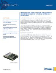
DATASHEET<br />
TRIMBLE <strong>AP50</strong><br />
GNSS-INERTIAL OEM SYSTEM<br />
EMBEDDED GNSS-INERTIAL SYSTEMS FOR CONTINUOUS MOBILE<br />
POSITIONING AND DIRECT GEOREFERENCING APPLICATIONS<br />
KEY FEATURES<br />
Proven GNSS-Aided Inertial technology<br />
from Trimble <strong>Applanix</strong><br />
Centimeter level mobile positioning<br />
accuracy<br />
Industry leading continuous positioning<br />
performance in GNSS denied<br />
environments<br />
Full position and orientation solution for<br />
direct georeferencing of remote sensing<br />
systems<br />
Fully supported for all dynamic<br />
environments: terrestrial, airborne and<br />
marine<br />
The Trimble <strong>AP50</strong> GNSS-Inertial OEM<br />
System is an embedded GNSS-Inertial<br />
OEM board set plus Inertial Measurement<br />
Unit (IMU) in a compact form factor. It<br />
is designed to give system integrators<br />
the ability to harness the best in GNSS<br />
multi-frequency positioning technology,<br />
with the superior capabilities of inertial<br />
data for continuous mobile positioning<br />
in poor signal environments, and for the<br />
orientation of imaging sensors.<br />
The Trimble <strong>AP50</strong> features a highperformance<br />
precision GNSS receiver and<br />
the industry leading <strong>Applanix</strong> IN-Fusion TM<br />
GNSS-Inertial integration technology<br />
running on a powerful, dedicated Inertial<br />
Engine (IE) board. This flexible, modular<br />
design ensures the ability to perform full<br />
high-powered GNSS-inertial processing<br />
without sacrificing performance, and an<br />
upgrade path to next generation GNSS<br />
boards as they become available.<br />
PERFORMANCE YOU CAN TRUST<br />
Whether it be guiding autonomous<br />
vehicles to winning finishes in the DARPA<br />
Urban challenge,motion compensating<br />
multibeam sonar to meet IHO standards, or<br />
georeferencing airborne laser scanners to<br />
centimetre level accuracy from high in the<br />
sky, Trimble GNSS with <strong>Applanix</strong> inertial<br />
technology has a proven track record of<br />
performance without compromise. With<br />
Trimble AP products you know exactly<br />
what positioning performance you will get<br />
for your mobile application.<br />
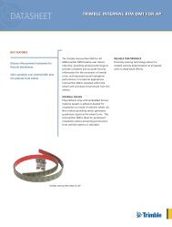
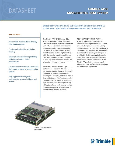
Trimble <strong>AP50</strong> GNSS-Inertial<br />
OEM System
TRIMBLE <strong>AP50</strong> GNSS-INERTIAL OEM SYSTEM<br />
TECHNICAL SPECIFICATIONS<br />
• Advanced <strong>Applanix</strong> IN-Fusion TM GNSS-Inertial integration technology<br />
• Advanced Trimble Maxwell ® 6 Custom GNSS survey technology (two chipsets)<br />
• 220 Channels: (per chipset)<br />
– GPS: L1 C/A, L2C, L2E (Trimble method for tracking unencrypted) L5<br />
– GLONASS: L1 C/A and unencrypted P code, L2 C/A and unencrypted P code,<br />
L3 CDMA 9<br />
– GALILEO 10 : L1 CBOC, E5A, E5B, E5AltBOC 9<br />
– QZSS: L1 C/A, L1C, L1 SAIF, L2C, L5, LEX 11<br />
– SBAS: L1 C/A (EGNOS/MSAS), L1 C/A and L5 (WAAS)<br />
– L-Band: OmniSTAR VBS, HP, XP and G2<br />
• High precision multiple correlator for GNSS pseudorange measurements<br />
• Unfiltered, unsmoothed pseudorange measurements data for low noise, low multipath<br />
error, low time domain correlation and high dynamic response<br />
• Very low noise GNSS carrier phase measurements with 1 msec<br />
width, max rate 100 Hz<br />
PERFORMANCE SPECIFICATIONS¹ (RMS ERROR)<br />
Airborne Applications<br />
SPS DGPS XP³ Post-Processed 4<br />
Position (m) 1.5 – 3.0 0.5 – 2.0 0.1 – 0.5 0.05 – 0.30<br />
Velocity (m/s) 0.050 0.050 0.010 0.005<br />
Roll & Pitch (deg) 0.008 0.008 0.008 0.005<br />
True Heading 2 (deg) 0.070 0.050 0.040 0.008<br />
Marine Applications, No GNSS Outages<br />
SPS DGPS IARTK 6 Post-Processed 4<br />
Position (m) 1.5 - 3 0.5 – 2 0.02 – 0.1 0.02 – 0.05<br />
Velocity (m/s) 0.050 0.050 0.010 0.005<br />
Roll & Pitch (deg) 0.010 0.008 0.008 0.005<br />
True Heading5 (deg) 0.020 0.020 0.020 0.020<br />
Terrestrial Applications 7 , No GNSS Outages<br />
SPS VBS 8 IARTK 6 Post-Processed 4<br />
Position (m) 1.5 – 3.0 0.1 – 0.5 0.02 – 0.05 0.02 – 0.05<br />
Velocity (m/s) 0.050 0.010 0.010 0.005<br />
Roll & Pitch (deg) 0.010 0.008 0.008 0.005<br />
True Heading 2 (deg) 0.050 0.020 0.020 0.015<br />
Terrestrial Applications 7 , 1 km or 1 minute GNSS Outage<br />
SPS VBS 8 IARTK 6 Post-Processed 4<br />
Position (m) 4.0 0.42 – 0.53 0.10 – 0.30 0.07 – 0.10<br />
Roll & Pitch (deg) 0.010 0.008 0.008 0.005<br />
True Heading 2 (deg) 0.050 0.020 0.020 0.015<br />
PHYSICAL CHARACTERISTICS<br />
Board Set<br />
Size:<br />
130 L x 100 W x 39 H mm (nominal)<br />
Weight:<br />
0.28 kg (nominal)<br />
Power:<br />
10 – 28 Volts DC, 20 Watts (max, with GAMS option)<br />
Connectors: I/O: Samtec QSH-060-01-L-D-DP-A-RT1<br />
Power: Samtec TFM-105-12-S-D-LC<br />
Antenna: MMCX receptacle<br />
ENVIRONMENTAL CHARACTERISTICS<br />
Temperature: -40 deg C to +75 deg C (Operational)<br />
-55 deg C to +85 deg C (Storage)<br />
Inertial Measurement Unit (IMU)<br />
Type Class Temperature Power<br />
IMU-31 COM<br />
IMU-8<br />
MIL<br />
-22 deg C to +<br />
55 deg C<br />
-40 deg C to +<br />
71 deg C<br />
+28 Vdc, 42 W<br />
(max)<br />
+/ 5 Vdc, +/- 15<br />
Vdc, 19 W (max)<br />
Size<br />
(L x W x H) mm Weight<br />
163 x 130 x 137 2.6 kg<br />
95 L X 95 W X<br />
107 H<br />
1.0 kg<br />
1 Typical performance. Actual results are dependent upon satellite configuration, atmospheric conditions<br />
and other environmental effects<br />
2 Typical mission profile, max RMS error<br />
3 OmniStar XP service, typical airborne results, subject to regional coverage. Subscription sold separately.<br />
4 POSPac MMS<br />
5 With GAMS option, 2 m baseline<br />
6 <strong>Applanix</strong> IN-Fusion Inertially-Aided RTK, typical results<br />
7 With DMI option<br />
8 Virtual Base Station corrections<br />
9 There is no public GLONASS L3 CDMA ICD. The current capability in the receivers is based on publicly<br />
available information. As such, Trimble cannot guarantee that these receivers will be fully compatible<br />
with a future generation of GLONASS satellites or signals.<br />
10 Developed under a License of the European Union and the European Space Agency.<br />
11 Pilot observable.<br />
© 2012, Trimble Navigation Limited. All rights reserved. Trimble and the Globe & Triangle logo are trademarks of<br />
Trimble Navigation Limited, registered in the United States and in other countries. All other trademarks are the<br />
property of their respective owners.<br />
Specifications subject to change without notice.<br />
www.trimble.com/gnss-inertial<br />
Trimble <strong>Applanix</strong><br />
85 Leek Crescent<br />
Richmond Hill Ontario<br />
L4B 3B3<br />
Canada<br />
T +1-289-695-6000 F +1-905-709-6027<br />
email: info@applanix.com April 2012