Edifice growth, deformation and rift zone development in basaltic ...
Edifice growth, deformation and rift zone development in basaltic ...
Edifice growth, deformation and rift zone development in basaltic ...

You also want an ePaper? Increase the reach of your titles
YUMPU automatically turns print PDFs into web optimized ePapers that Google loves.
L. Michon et al. / Journal of Volcanology <strong>and</strong> Geothermal Research 184 (2009) 14–30<br />
15<br />
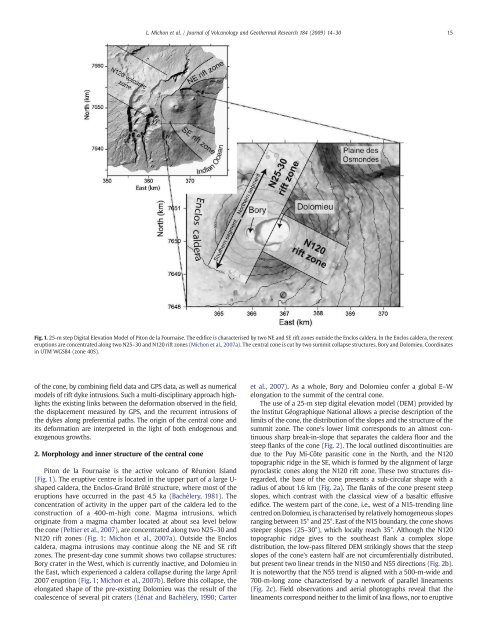
Fig. 1. 25-m step Digital Elevation Model of Piton de la Fournaise. The edifice is characterised by two NE <strong>and</strong> SE <strong>rift</strong> <strong>zone</strong>s outside the Enclos caldera. In the Enclos caldera, the recent<br />
eruptions are concentrated along two N25–30 <strong>and</strong> N120 <strong>rift</strong> <strong>zone</strong>s (Michon et al., 2007a). The central cone is cut by two summit collapse structures, Bory <strong>and</strong> Dolomieu. Coord<strong>in</strong>ates<br />
<strong>in</strong> UTM WGS84 (<strong>zone</strong> 40S).<br />
of the cone, by comb<strong>in</strong><strong>in</strong>g field data <strong>and</strong> GPS data, as well as numerical<br />
models of <strong>rift</strong> dyke <strong>in</strong>trusions. Such a multi-discipl<strong>in</strong>ary approach highlights<br />
the exist<strong>in</strong>g l<strong>in</strong>ks between the <strong>deformation</strong> observed <strong>in</strong> the field,<br />
the displacement measured by GPS, <strong>and</strong> the recurrent <strong>in</strong>trusions of<br />
the dykes along preferential paths. The orig<strong>in</strong> of the central cone <strong>and</strong><br />
its <strong>deformation</strong> are <strong>in</strong>terpreted <strong>in</strong> the light of both endogenous <strong>and</strong><br />
exogenous <strong>growth</strong>s.<br />
2. Morphology <strong>and</strong> <strong>in</strong>ner structure of the central cone<br />
Piton de la Fournaise is the active volcano of Réunion Isl<strong>and</strong><br />
(Fig. 1). The eruptive centre is located <strong>in</strong> the upper part of a large U-<br />
shaped caldera, the Enclos-Gr<strong>and</strong> Brûlé structure, where most of the<br />
eruptions have occurred <strong>in</strong> the past 4.5 ka (Bachèlery, 1981). The<br />
concentration of activity <strong>in</strong> the upper part of the caldera led to the<br />
construction of a 400-m-high cone. Magma <strong>in</strong>trusions, which<br />
orig<strong>in</strong>ate from a magma chamber located at about sea level below<br />
the cone (Peltier et al., 2007), are concentrated along two N25–30 <strong>and</strong><br />
N120 <strong>rift</strong> <strong>zone</strong>s (Fig. 1; Michon et al., 2007a). Outside the Enclos<br />
caldera, magma <strong>in</strong>trusions may cont<strong>in</strong>ue along the NE <strong>and</strong> SE <strong>rift</strong><br />
<strong>zone</strong>s. The present-day cone summit shows two collapse structures:<br />
Bory crater <strong>in</strong> the West, which is currently <strong>in</strong>active, <strong>and</strong> Dolomieu <strong>in</strong><br />
the East, which experienced a caldera collapse dur<strong>in</strong>g the large April<br />
2007 eruption (Fig. 1; Michon et al., 2007b). Before this collapse, the<br />
elongated shape of the pre-exist<strong>in</strong>g Dolomieu was the result of the<br />
coalescence of several pit craters (Lénat <strong>and</strong> Bachèlery, 1990; Carter<br />
et al., 2007). As a whole, Bory <strong>and</strong> Dolomieu confer a global E–W<br />
elongation to the summit of the central cone.<br />
The use of a 25-m step digital elevation model (DEM) provided by<br />
the Institut Géographique National allows a precise description of the<br />
limits of the cone, the distribution of the slopes <strong>and</strong> the structure of the<br />
summit <strong>zone</strong>. The cone's lower limit corresponds to an almost cont<strong>in</strong>uous<br />
sharp break-<strong>in</strong>-slope that separates the caldera floor <strong>and</strong> the<br />
steep flanks of the cone (Fig. 2). The local outl<strong>in</strong>ed discont<strong>in</strong>uities are<br />
due to the Puy Mi-Côte parasitic cone <strong>in</strong> the North, <strong>and</strong> the N120<br />
topographic ridge <strong>in</strong> the SE, which is formed by the alignment of large<br />
pyroclastic cones along the N120 <strong>rift</strong> <strong>zone</strong>. These two structures disregarded,<br />
the base of the cone presents a sub-circular shape with a<br />
radius of about 1.6 km (Fig. 2a). The flanks of the cone present steep<br />
slopes, which contrast with the classical view of a <strong>basaltic</strong> effusive<br />
edifice. The western part of the cone, i.e., west of a N15-trend<strong>in</strong>g l<strong>in</strong>e<br />
centred on Dolomieu, is characterised by relatively homogeneous slopes<br />
rang<strong>in</strong>g between 15° <strong>and</strong> 25°. East of the N15 boundary, the cone shows<br />
steeper slopes (25–30°), which locally reach 35°. Although the N120<br />
topographic ridge gives to the southeast flank a complex slope<br />
distribution, the low-pass filtered DEM strik<strong>in</strong>gly shows that the steep<br />
slopes of the cone's eastern half are not circumferentially distributed,<br />
but present two l<strong>in</strong>ear trends <strong>in</strong> the N150 <strong>and</strong> N55 directions (Fig. 2b).<br />
It is noteworthy that the N55 trend is aligned with a 500-m-wide <strong>and</strong><br />
700-m-long <strong>zone</strong> characterised by a network of parallel l<strong>in</strong>eaments<br />
(Fig. 2c). Field observations <strong>and</strong> aerial photographs reveal that the<br />
l<strong>in</strong>eaments correspond neither to the limit of lava flows, nor to eruptive