

16.6 MB pdf - IRIS
16.6 MB pdf - IRIS
16.6 MB pdf - IRIS

You also want an ePaper? Increase the reach of your titles
YUMPU automatically turns print PDFs into web optimized ePapers that Google loves.
Seismology plays key role in addressing many needs of<br />
broader society, including energy resources, environment,<br />
national security, and several natural hazards. In no area,<br />
however, are the uniquely important impacts from seismological<br />
research more evident than in addressing earthquake<br />
hazard. National Earthquake Resilience: Research,<br />
Implementation, and Outreach (NRC, 2011) details how seismologists<br />
must contribute by making near-field measurements<br />
to understand the physics of earthquake processes; evaluating<br />
and testing earthquake early warning systems and methods<br />
for operational earthquake forecasting; completing national<br />
seismic hazard maps and creating urban seismic hazard maps;<br />
enabling robust coupled simulations of fault rupture, seismic<br />
wave propagation, and soil response to reliably estimate losses<br />
and casualties; and contributing to scenarios so that communities<br />
can visualize earthquake impacts.<br />
Lowermost Mantle Global Structure<br />
Seismologists are collaborating with geodesists, geodynamicists<br />
and materials scientists to determine density, temperature<br />
and other mantle properties that cannot be measured from<br />
seismic wavespeeds alone (Simmons et al., 2010). This progress<br />
comes, in part, from resolving the structure of large, low-shear<br />
velocity provinces at the base of the mantle with the accumulation<br />
of high-quality broadband data from the GSN and its international<br />
counterparts, as well as dense PASSCAL and USArray<br />
deployments. This work brings out the distinct average velocity<br />
profiles within and outside irregularly shaped high- and lowvelocity<br />
provinces in the lowermost mantle. Modeling of broadband<br />
waves that propagate along and across the province<br />
borders show that they are sharp, indicating that the distinctive<br />
properties cannot be due only to temperature differences.<br />
If large, chemically distinct reservoirs continue to exist in the<br />
mantle, then occasional reorganization of mantle circulation<br />
could profoundly alter cycling of volatiles between Earth’s interior<br />
and the ocean and atmosphere.<br />
Independent models of global shear wave speed in the lower mantle<br />
are in increasingly good agreement. This map is composed of bins that<br />
are color-coded according to how many of five well-regarded models<br />
have a V S profile that cluster analysis identifies as distinctly slow. The<br />
analysis demonstrates consensus on two large low-shear wave speed<br />
provinces, the African and the Pacific, within a single, globally contiguous<br />
faster-than-average lower mantle. (Lekic et al., submitted)<br />
5<br />
4<br />
3<br />
2<br />
1<br />
0<br />
In what follows, a set of key questions derived from<br />
Seismological Grand Challenges in Understanding Earth’s<br />
Dynamic System (Lay, 2009) is used to illustrate the ways in<br />
which seismology, and the resources provided by the <strong>IRIS</strong><br />
facilities, contribute to a broad range of topics that enhance<br />
our understanding of fundamental Earth processes and the<br />
ways in which they impact our lives.<br />
Thermo-Chemical Internal Dynamics<br />
and Volatile Distribution<br />
How do Earth’s temperature, composition, and internal boundaries<br />
control mantle and core dynamics and the changing<br />
morphology of our living environment? How do the lithosphere<br />
and plate boundary systems evolve over Earth history?<br />
The solid Earth is a complex and dynamic system with<br />
processes that operate over spatial scales from nanometers<br />
to tens of thousands of kilometers and time scales from<br />
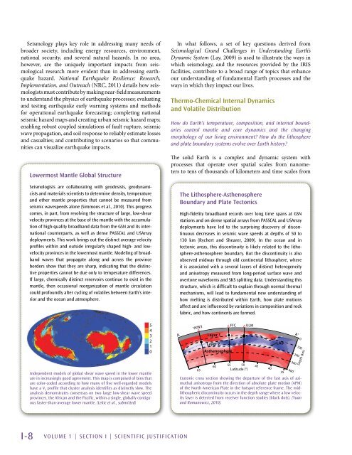
The Lithosphere-Asthenosphere<br />
Boundary and Plate Tectonics<br />
High-fidelity broadband records over long time spans at GSN<br />
stations and on dense spatial arrays from PASSCAL and USArray<br />
deployments have led to the surprising discovery of discontinuous<br />
decreases in seismic wave speeds at depths of 50 to<br />
130 km (Rychert and Shearer, 2009). In the ocean and in<br />
tectonic areas, this discontinuity is likely related to the lithosphere-asthenosphere<br />
boundary. But the discontinuity is also<br />
observed midway through old continental lithosphere, where<br />
it is associated with a several layers of distinct heterogeneity<br />
and anisotropy measured from long-period surface wave and<br />
overtone waveforms and SKS splitting data. Understanding this<br />
structure, which is difficult to explain through normal thermal<br />
mechanisms, will lead to fundamental new understanding of<br />
how melting is distributed within Earth, how plate motions<br />
affect and are influenced by variations in composition and rock<br />
fabric, and how continents are formed.<br />
A<br />
YKW3<br />
∆<br />
Layer 1<br />
∆<br />
FFC<br />
Layer 2<br />
Asthenosphere<br />
50<br />
60<br />
55<br />
45<br />
65<br />
Latitude (°)<br />
40<br />
35<br />
Cratonic cross section showing the departure of the fast axis of azimuthal<br />
anisotropy from the direction of absolute plate motion (APM)<br />
of the North American Plate in the hotspot reference frame. The midlithospheric<br />
discontinuity occurs in the depth range where a low velocity<br />
layer is detected from receiver function studies (black dots). (Yuan<br />
and Romanowicz, 2010).<br />
∆<br />
ULM<br />
LAB<br />
400<br />
300<br />
A’<br />
200<br />
0<br />
100<br />
Depth (km)<br />
I-8 VOLUME 1 | Section I | Scientific Justification


