

16.6 MB pdf - IRIS
16.6 MB pdf - IRIS
16.6 MB pdf - IRIS

Create successful ePaper yourself
Turn your PDF publications into a flip-book with our unique Google optimized e-Paper software.
ealistic shaking scenarios for regional demonstration projects<br />
with physics-based simulations of damage and improved<br />
earthquake hazard and loss assessment. The development of<br />
such new insights is accelerated dramatically by earthquakes<br />
or eruptions of particular significance, but the timing of these<br />
events cannot be anticipated. Thus, we must be ready by operating<br />
a fiducial network of seismic observatories, maintaining<br />
state-of-the-art portable instruments that can be deployed<br />
rapidly when important earthquake and volcanic eruption<br />
sequences occur, and developing capabilities for rapid<br />
warning of earthquake shaking.<br />
Change and Interactions Among Climate,<br />
Hydrology, Surface Processes, and Tectonics<br />
How do Earth dynamics and structure relate to the distribution<br />
of freshwater and energy resources? How do the coupled systems<br />
respond to natural and anthropogenic forcing?<br />
Seismology has an overwhelmingly important role to play in<br />
the development of energy options for the 21 st century, and<br />
is an important complement to other geophysical techniques<br />
in managing water resources. PASSCAL and FA deployments<br />
increasingly facilitate 3D seismic imaging at the reservoir<br />
and basin scales that are of central importance to oil and gas<br />
exploration and to optimal management of existing fields.<br />
Induced earthquakes monitored by networked instruments<br />
have had impacts on geothermal energy, where they have led<br />
to operations being shut down. Induced earthquakes have<br />
also had an impact on shale gas development where they have<br />
been implicated in operations to re-inject flowback water. If<br />
CO 2 sequestration is to happen at a scale to mitigate climate<br />
change, induced earthquakes are likely to place important<br />
constraints on that activity as well. The future of nuclear<br />
power plant construction and high-level radioactive waste<br />
disposal is critically dependent on developing a predictive<br />
understanding of earthquake behavior, particularly in areas<br />
of low seismic hazard.<br />
A new generation of integrated power and data acquisition<br />
systems developed by experienced PASSCAL and<br />
UNAVCO engineers has facilitated growth and success of the<br />
Polar Earth Observing Network (POLENET)—a project to<br />
collect seismic and geodetic data from autonomous systems<br />
deployed at remote sites spanning much of the Antarctic ice<br />
sheet to answer critical questions about their behavior in a<br />
warming world. Combining these POLENET measurements<br />
with ground-based measurements of gravity, sea level, and the<br />
atmosphere and with satellite measurements will lead to better<br />
ice sheet budgets, link ice sheet change to the global Earth<br />
system, and provide a deeper understanding of how polar ice<br />
sheets contribute to changing sea levels around the world.<br />
<strong>IRIS</strong>’s role in the Greenland Ice Sheet Monitoring Network<br />
(GLISN) has established a real-time array of seismic stations<br />
Glacial and Iceberg “Earthquakes”<br />
Recent deployments of broadband seismometers on ice sheets<br />
and icebergs have recorded breakup in the Ross Sea near<br />
Antarctica, calving of ice off the end of glaciers, and iceberg<br />
fracturing. The records are yielding new insights into these<br />
processes, which may be accelerating due to climate change.<br />
Glacial earthquakes were discovered recently as low-frequency<br />
signals in seismograms from the GSN. Many of the events that<br />
occur during the late summer along the coasts of Greenland<br />
are clustered near large outlet glaciers. The rate of glacialearthquake<br />
occurrence varies from year to year, increasing<br />
quickly between 2000 and 2005 but continuing at a steady<br />
rate more recently. Variations in glacier-terminus position and<br />
retreat rate between seasons and between years account in<br />
general for variation in the rate of occurrence of glacial earthquakes.<br />
Seismological measurement of glacier and iceberg<br />
dynamics adds a new tool both for monitoring and for retrospective<br />
studies of 20 th century activity, but on-site investigations<br />
to discover the mechanisms by which glacial phenomena<br />
generate seismic signals are needed to maximize returns from<br />
multidisciplinary data analysis.<br />
66.60<br />
66.55<br />
66.50<br />
66.45<br />
66.40<br />
66.35<br />
66.30<br />
GPS/NRS<br />
GPS/Gonz<br />
Camera<br />
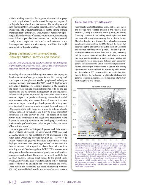
Helheim Network 2009<br />
Seismometer<br />
AWS<br />
Tide gauge<br />
–38.7 –38.6 –38.5 –38.4 –38.3 –38.2 –38.1 –38.0<br />
“Studies of Earthquakes and Rapid Motions of Ice” used PASSCAL and<br />
other instruments to focus on East Greenland’s two largest outlet glaciers,<br />
Helheim glacier and Kangerdlugssuaq glacier. This map shows<br />
seismological, geodetic, photographic, and other systems used for local<br />
monitoring of Helheim glacier during the summer of 2009, collected<br />
in the field and via remote sensing, to build an understanding of flow<br />
dynamics and short-timescale glacier behavior. The data demonstrated<br />
that the times of glacial earthquakes are strongly correlated with large<br />
calving events, which result in rapid changes in glacier speed. The seismic<br />
signals were generated by impacts on the face of the glacier and the<br />
underlying solid Earth when cubic-kilometer-scale icebergs capsized.<br />
(Nettles and Ekström, 2010)<br />
I-12 VOLUME 1 | Section I | Scientific Justification


