

16.6 MB pdf - IRIS
16.6 MB pdf - IRIS
16.6 MB pdf - IRIS

Create successful ePaper yourself
Turn your PDF publications into a flip-book with our unique Google optimized e-Paper software.
from movement on geologic structures created by past<br />
tectonic events. The regularity and consistency of the TA<br />
make it possible to better understand these processes, which is<br />
required to assess if time-dependent seismic hazard estimates<br />
for sites of historical damaging earthquakes in central and<br />
eastern North America is even feasible. Our understanding<br />
will be widened with an enormous quantity of new data from<br />
the arc-trench system on the southern margin of Alaska, the<br />
active Aleutian volcanic arc, and the St. Elias Range where the<br />
Yakutat terrane collides with coastal Alaska.<br />
The availability of thousands of inexpensive and easily<br />
deployed sensors and data acquisition systems in the FA pool<br />
has facilitated rapid progress in studying episodic tremor and<br />
slip, and motivated innovation in data processing such as new<br />
multibeam back-projection methods that have been used to<br />
map migration of tremors over days and weeks. Newly discovered<br />
classes of earthquakes and patterns of tremor and slip<br />
have profound and as yet only partially understood implications<br />
for understanding the physics of fault friction and slip.<br />
Resonance in basins and focusing of seismic waves by<br />
surrounding structures are major contributors to geographic<br />
Episodic Tremor and Slip<br />
An exciting recent advance in seismology is recognition of<br />
a wide range of rupture behaviors in and near major faults<br />
zones, including “slow earthquakes” and regional seismic<br />
tremor synchronous with geodetically measured episodic slip.<br />
Seismic tremor was first recognized as a regional phenomenon,<br />
rather than a probably anthropomorphic effect at a<br />
single station, after deployment and joint analysis of dense<br />
regional arrays, such as the Transportable Array and dense<br />
permanent networks in Japan. The geodetic evidence shows<br />
tectonic slip many orders of magnitude slower and often<br />
deeper than “regular” earthquakes. Some tremor and slow slip<br />
events occur regularly with periods of months to years, others<br />
are aperiodic, and still others appear to be triggered by distant<br />
earthquakes, suggesting that deeper portions of the fault are<br />
only marginally stable.<br />
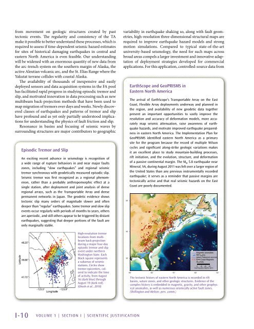
High-resolution tremor<br />
locations from multibeam<br />
back-projection<br />
during a major four-day<br />
episodic tremor and slip<br />
event under northern<br />
Washington State. Each<br />
black square represents<br />
a subarray of seismic<br />
stations. Circles show<br />
tremor epicenters, colored<br />
to indicate the time<br />
of activity, from August<br />
16 (dark blue) through<br />
August 19 (dark red).<br />
(Ghosh et al., 2010)<br />
variability in earthquake shaking so, along with fault geometries,<br />
high-resolution three-dimensional structural maps are<br />
required to improve earthquake hazard models and strong<br />
motion simulations. Compared to typical state-of-the-art<br />
university-based seismology, the need for such maps across<br />
broad areas compels a larger investment and innovative adaptation<br />
of deployment strategies developed for commercial<br />
applications. For this application, controlled-source data from<br />
50˚<br />
40˚<br />
30˚<br />
EarthScope and GeoPRISMS in<br />
Eastern North America<br />
The arrival of EarthScope’s Transportable Array on the East<br />
Coast, Flexible Array deployments underway and planned in<br />
the region, and availability of new geodetic data together<br />
present an important opportunities to vastly improve the<br />
resolution and accuracy of deformation models, more accurately<br />
map seismic attenuation, raise awareness of earthquake<br />
hazards, and motivate improved earthquake preparedness<br />
in eastern North America. The Implementation Plan for<br />
GeoPRSIMS identified eastern North America as a primary<br />
site for the program because the record of multiple Wilson<br />
cycles and significant along-strike geologic variations makes<br />
it an excellent place to study mountain-building processes,<br />
rift initiation, and the evolution, structure, and deformation<br />
of a passive continental margin. The M W 5.8 earthquake near<br />
Mineral, VA, during August 2011 was felt over a larger region of<br />
the United States than any previous instrumentally recorded<br />
earthquake; it serves as a reminder that passive margins are<br />
tectonically active and that real seismic hazards on the East<br />
Coast are poorly documented.<br />
0<br />
0<br />
-90˚ -80˚ -70˚ -60˚ -50˚<br />
The tectonic history of eastern North America is recorded in rift<br />
basins, suture zones, and other geologic structures. Evidence of the<br />
complex history is embedded in magnetic, gravity, and other geophysical<br />
anomalies, as well as numerous seismically active fault zones.<br />
(Shillington and Meltzer, pers. comm.)<br />
0<br />
0<br />
0<br />
Magnetic anomalies<br />
Rift basins<br />
select Paleozoic sutures<br />
East Coast Magnetic<br />
Anomaly<br />
0 10 20 30<br />
Earthquake depths (km)<br />
I-10 VOLUME 1 | Section I | Scientific Justification


