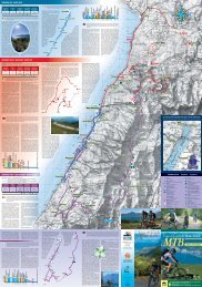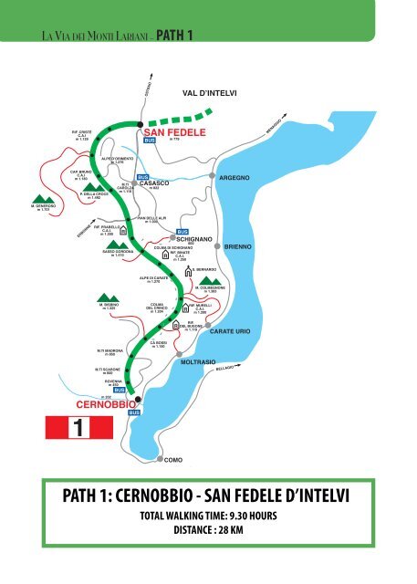
PATH 1: CERNOBBIO - SAN FEDELE D'INTELVI
PATH 1: CERNOBBIO - SAN FEDELE D'INTELVI
PATH 1: CERNOBBIO - SAN FEDELE D'INTELVI

Create successful ePaper yourself
Turn your PDF publications into a flip-book with our unique Google optimized e-Paper software.
DONGO<br />
LA VIA DEI MONTI LARIANI - <strong>PATH</strong> 1<br />
OSTENO<br />
VAL D’INTELVI<br />
RIF. CRISTÈ<br />
C.A.I<br />
m 1.129<br />
<strong>SAN</strong> <strong>FEDELE</strong><br />
BUS<br />
m 779<br />
MENAGGIO<br />
ALPE D’ORIMENTO<br />
m 1.276<br />
CAP. BRUNO<br />
C.A.I<br />
m 1.180<br />
P. DELLA CROCE<br />
m 1.492<br />
M.TI<br />
CAROLZA<br />
m 1.110<br />
BUS<br />
CASASCO<br />
m 822<br />
ARGEGNO<br />
M. GENEROSO<br />
m 1.701<br />
ERBONNE<br />
RIF. PRABELLO<br />
C.A.I. R<br />
m 1.200<br />
SASSO GORDONA<br />
m 1.410<br />
PIAN DELLE ALPI<br />
m 1.000<br />
COLMA DI SCHIGNANO<br />
R<br />
BUS<br />
SCHIGNANO<br />
600<br />
RIF. BINATE<br />
C.A.I.<br />
m 1.250<br />
BRIENNO<br />
S. BERNARDO<br />
ALPE DI CARATE<br />
m 1.270<br />
M. COLMEGNONE<br />
m 1.383<br />
M. BISBINO<br />
m 1.325<br />
COLMA<br />
DEL CRINCO<br />
m 1.204<br />
RIF. MURELLI<br />
R C.A.I.<br />
m 1.200<br />
RIF.<br />
R DEL BUGONE<br />
m 1.119<br />
CARATE URIO<br />
M.TI MADRONA<br />
m 850<br />
M.TI SCARONE<br />
m 600<br />
CÀ BOSSI<br />
m 1.150<br />
MOLTRASIO<br />
BELLAGIO<br />
ROVENNA<br />
m 450<br />
m 202<br />
<strong>CERNOBBIO</strong><br />
1<br />
BUS<br />
BUS<br />
COMO<br />
VALLE ALBANO<br />
<strong>PATH</strong> 1: <strong>CERNOBBIO</strong> - <strong>SAN</strong> <strong>FEDELE</strong> D’INTELVI<br />
RIF. GIOVO<br />
C.A.I.<br />
RIF. SOMMMAFIUME<br />
C.A.I.<br />
TOTAL WALKING TIME: 9.30 HOURS<br />
BRENZEGLIO<br />
DISTANCE : 28 KM<br />
662<br />
GARZENO<br />
CATASCO<br />
BUS<br />
SORICO<br />
GRAVEDONA
LA VIA DEI MONTI LARIANI - <strong>PATH</strong> 1<br />
On the first part of this section one has to deal<br />
with an ascent of 1000 m up the slopes of<br />
Monte Bisbino. The second part has less ascent,<br />
offers beautiful views and runs along Sasso<br />
Gordona with its tunnels and emplacements<br />
built during the first World War.<br />
<strong>CERNOBBIO</strong> (200 m.) The ‘VIA DEI MONTI<br />
LARIANI’ starts at Cernobbio in Piazza Mazzini<br />
where the main bus stop is. Cross the main<br />
road, pick up Via A. Volta and when you get to<br />
a circus continue straight on in the direction of<br />
Pian delle Alpi (photo Giuseppe Venini)<br />
Rovenna and Monte Bisbino. At the end of the<br />
road, just past the bend, after 20 m, pick up Via<br />
G. Parini on the left. Once on the road again, follow it as far as Casnedo and at the church turn right. Cross a bridge and<br />
take left and pass through the village Stomaino. A shortcut leads to<br />
ROVENNA (450 m. 0.45 hours) – which can also be reached by bus (line C28) from Cernobbio. You pass the church<br />
square (where also the bus stop is). At the bend turn left following the indications for Scarone and Madrona. After a<br />
brief stretch you reach the beginning of the mule track that leads up in large bends to MONTE SCARONE and from<br />
there to<br />
MADRONA (850 m. 1.00 ; 1.45 hours). Follow the road up to the second curve, where you pick up the mule-track to<br />
Monte Bisbino which passes by the chapel of S. Carlo. At the end of the mule-track, before reaching the road leading to<br />
the top of Monte Bisbino turn right in order to reach<br />
CA’ BOSSI (1188 n. 1.00 ; 2.45 hours). From here a wide track goes slightly downhill to<br />
COLMA DAL BUGONE (1119 m. 0.40 , 3.25 hours) where rifugio Bugone is located. This is where two paths coming<br />
up from Moltrasio meet. You pass ancient beech-woods and get beautiful views of the lake, the Western Alps, Monte Generoso<br />
and Sasso Gordona. Past COLMA DEL CRINCO the ‘Via’ leads on to the<br />
COLMA DEI MURELLI (1200 m 0.45 ; 4.05 hours) where you find Rifugio Murelli [From this point you can make a detour<br />
of about half an hour to Monte Colmegnone (1383 m.), which has a magnificent view, or to Monte San Bernardo (1348<br />
m.) with its characteristic little church and Agriturismo. From Colma dei Murelli an easy cart-track leads to ALPE DI<br />
CARATE where you pick up the mule-track to<br />
RIFUGIO BINATE (1200 m. 0.35 ; 4.40 hours) From here the mule-track becomes a path which runs half way up the<br />
mountainside, the Swiss-facing slope, through fields and alpine pastures to<br />
COLMA DI SCHIGNANO (also called della Crocetta) (1135 m. 0.20 ; 5.00 hours) [ from here it’s possible to go down<br />
to Schignano (0,45 min) where there is a bus stop or to Argegno (2.00 hrs)]. At the next intersection at the height of a cross,<br />
take right over to the side that faces the Val d’ Intelvi and continue on an old military road that leads around Sasso Gordona.<br />
Inside this mountain there are tunnels with emplacements. In fact Sasso Gordona was part of the great defence<br />
line called Linea Cadorna, built in 1915 along the Swiss-Italian border, to thwart a possible German offence. At the intersection<br />
with the indication Alpe Cerano / San Fedele turn right. [The ones who have booked an overnight stay at Rifugio<br />
Prabello (1200m) go straight on and will reach the “rifugio” in about 15 min.] An easy track leads down to<br />
ALPE DI CERANO (960 m 0.50 ; 5.50 hrs) (also called Pian delle Alpi) –[ road connection with Casasco 40 min.<br />
where there is a bus stop (line C21).] Follow the road Casasco to Erbonne to the right, and just past the pic-nic area<br />
leave the road and pick up the mule-track to the left in the direction of Erbonne (sign). At the intersection with some
LA VIA DEI MONTI LARIANI - <strong>PATH</strong> 1<br />
trail signs on a tree, turn right and follow the track that leads up the farm house of ERMOGNA.<br />
Before reaching the farm house you pass a “bolla” a natural depression in the terrain adapted by man to conserve rainwater<br />
and create a beverage place for the cattle. Near the farmstead you notice a cylindrical formed construction called<br />
“nevera”. These constructions out of stone, which lead deep into the ground, were filled with snow (neve) and used to<br />
conserve food. The easy track leads to MONTE di CAROLZA (1100 m.). and from there after a stretch through the<br />
woods you reach some recently built houses above the town Casasco. Take left and follow the sign for Capanna Bruno<br />
/ San Fedele. Then you reach the road coming up from Casasco, follow it to the left and just past the bend with three<br />
crosses, leave the road and take the trail on the left leading up to the restaurant<br />
CAPANNA GIUSEPPE AND BRUNO (1180 m. 1.30 ; 7.20 hours). Just past the restaurant on the right you find the trail<br />
signs for Alpe Orimento / San Fedele. An almost flat trail leads over the steep fields of Mt. Crocione, and crosses under<br />
a ski lift. The trail leads on to a track and after a stretch downhill at the intersection, take the trail left leading uphill. At<br />
the next intersection keep left again in order to reach<br />
BOCCA DI ORIMENTO (1275 m. 0.45 ; 8.05 hours) where the inn Baita d’Orimento is located (starting point of the excursion<br />
to Monte Generoso (1701 m.). Follow the road leading down to Casasco to the right and after approx. 2 km you<br />
reach RIFUGIO CRISTE‘ (1250 m.) You remain on the road (there are some shortcuts if you want to cut some bends)<br />
that leads around two “bolle” and arrives at an intersection. You leave the road to your right, going to Casasco, and follow<br />
the road left in the direction of San Fedele. After 300 m you leave it and pick up a large cart track on the left leading<br />
to some houses. The cart track becomes a comfortable grassy trail, that leads through a pinewood and then down<br />
through meadowland in the direction of San Fedele, with splendid views of the Val d’Intelvi and the mountains of the<br />
Canton Ticino. The trail leads on to the road towards<br />
<strong>SAN</strong> <strong>FEDELE</strong> D’INTELVI (750 m. 1.25 ; 9.30 hours)- hotels - restaurants – bus stop (line C20/21/22) where near the<br />
bus depot, this section ends.<br />
Bocchetta di Nava (photo Jutta Bents)