Journey of a Raindrop
Journey of a Raindrop
Journey of a Raindrop

Create successful ePaper yourself
Turn your PDF publications into a flip-book with our unique Google optimized e-Paper software.
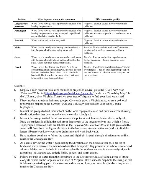
Surface What happens when water runs over Effects on water quality<br />
Large area <strong>of</strong><br />
pavement<br />
Parking lot<br />
Water flows rapidly, causing increased erosion after<br />
leaving the pavement.<br />
Water flows rapidly, causing increased erosion after<br />
leaving the pavement. Also, water picks up oil and<br />
engine fluid deposited in the lot.<br />
Negative: Erosion causes increased sediment<br />
pollution.<br />
Negative: Erosion causes increased sediment<br />
pollution; automotive products contribute to toxic<br />
pollution.<br />
Bare soil Water erodes and carries away soil. Negative: Erosion causes increased sediment<br />
pollution.<br />
Mulch<br />
Grass<br />
Forest<br />
Water travels slowly over bumpy mulch and soaks<br />
into the ground without carrying away soil.<br />
Water travels slowly over uneven surface and soaks<br />
into the ground; roots take in water and hold soil in<br />
place. Grass can filter out harmful toxins.<br />
Water travels the slowest in a forest. As it drips<br />
down through branches and leaves, much is taken in<br />
by trees’ and other forest plants’ roots, which also<br />
hold soil. The forest has the most plants, so it can<br />
filter out the most toxic pollution.<br />
Positive: Slower and reduced run<strong>of</strong>f decreases<br />
erosion and, therefore, decreases sediment<br />
pollution.<br />
Positive: Erosion and sediment pollution are<br />
further decreased; filtering decreases toxic<br />
pollution.<br />
Positive: The slowest and cleanest run<strong>of</strong>f comes<br />
from forests. It has the least sediment pollution<br />
and the least toxic pollution when compared to<br />
other surfaces.<br />
Session 4:<br />
1. Display a Web browser on a large monitor or projection device; go to the EPA’s Surf Your<br />
Watershed Web site (http://cfpub.epa.gov/surf/locate/index.cfm), and click “Search by Map.” In<br />
the U.S. map, click Virginia. Then click your area <strong>of</strong> Virginia to find your local watershed.<br />
2. Direct students to rejoin their map groups. Give each group a Virginia map, an enlarged local<br />
topographic map from the Virginia Atlas and Gazetteer that includes your school, and a<br />
highlighter.<br />
3. Instruct the groups to find their school on the local topographic map and draw an arrow showing<br />
the direction the class determined water leaves the schoolyard.<br />
4. Instruct the groups to find the stream nearest the point at which water leaves the schoolyard.<br />
Have the students highlight the path from that stream to the stream or river into which it flows.<br />
Topographic elevation lines are labeled in the Virginia Atlas and Gazetteer in light gray, and the<br />
water will flow from the higher elevation to the lower one. An alternative method is to find the<br />
larger tributary you know your area drains into and work backwards.<br />
5. Have students continue to follow the water and highlight its path through all tributaries until it<br />
reaches the Chesapeake Bay.<br />
6. As a class, review the water’s path, listing the directions on the board as you go. This list <strong>of</strong><br />
bodies <strong>of</strong> water between the schoolyard and the Chesapeake Bay provides the school’s watershed<br />
address. Make sure to include in the address details the students noticed in the schoolyard, such<br />
as parking lots, sandboxes, athletic fields, gutters, and storm drains.<br />
7. Follow the path <strong>of</strong> water from the schoolyard to the Chesapeake Bay, affixing a piece <strong>of</strong> string<br />
along its course on the large class wall map <strong>of</strong> Virginia. Have students help hold the string so that<br />
it follows the winding path <strong>of</strong> the streams and rivers as closely as possible. Cut the string when it<br />
reaches the Chesapeake Bay.