Anderson Landing - Kitsap County Government
Anderson Landing - Kitsap County Government
Anderson Landing - Kitsap County Government

Create successful ePaper yourself
Turn your PDF publications into a flip-book with our unique Google optimized e-Paper software.
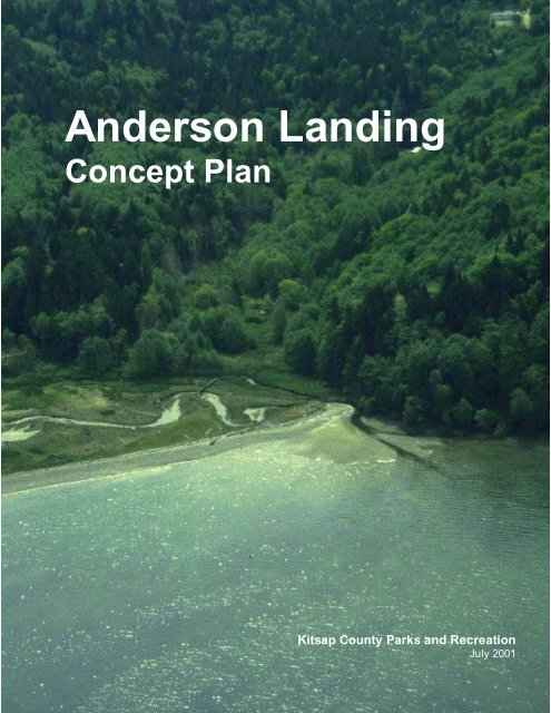
<strong>Anderson</strong> <strong>Landing</strong><br />
Concept Plan<br />
<strong>Kitsap</strong> <strong>County</strong> Parks and Recreation<br />
July 2001
<strong>Anderson</strong> <strong>Landing</strong><br />
Concept Plan<br />
Prepared for:<br />
<strong>Kitsap</strong> <strong>County</strong> Parks and Recreation<br />
Prepared by:<br />
MacLeod Reckord<br />
The Langlow Associates<br />
July 2001
Acknowledgements<br />
This Concept Plan would not have been possible without the assistance of a great number of individuals. We<br />
wish to thank the following people for their time and input:<br />
<strong>Kitsap</strong> <strong>County</strong><br />
Commissioners<br />
Chris Endreson, 1 st District<br />
Charlotte Garrido, 2 nd District (former)<br />
Jan Angel, 2 nd District<br />
Tim Botkin, 3 rd District<br />
Department of Parks and Recreation<br />
Cris Gears, Parks Director<br />
Rick Fackler, Principle Planner<br />
Joseph Coppo, Project Manager<br />
Department of Community Development<br />
Jeff Davis, Wildlife Biologist<br />
Department of Public Works<br />
Dick Dadisman<br />
Dave Dickson<br />
Organizations<br />
<strong>Anderson</strong> <strong>Landing</strong> Task Force<br />
Community Council for Central <strong>Kitsap</strong><br />
Hood Canal Coordinating Council<br />
Lone Rock Community Club<br />
Wildcat Lake Community Club<br />
Consultants<br />
MacLeod Reckord<br />
Terry Reckord, Principal<br />
Connie Reckord, Principal<br />
Vinita Sidhu, Project Designer<br />
The Langlow Associates<br />
Kristie Langlow, Principal<br />
Open Space, Parks & Greenways<br />
Advisory Council<br />
Connie Waddington, Chair<br />
Sid Knutson<br />
Mary Bertrand<br />
Pat Sprouse<br />
Tom Donnelly<br />
Judith Matchett<br />
Helen Daly<br />
Stephen Reeve<br />
Roger Gay<br />
Mike McCuddin<br />
Caryn Robertson<br />
Jolene Palmer<br />
We would also like to thank <strong>Kitsap</strong> <strong>County</strong> Parks and<br />
Recreation for providing the aerial and historic photographs<br />
of <strong>Anderson</strong> <strong>Landing</strong> reproduced in this report.
Table of Contents<br />
Executive Summary 1<br />
Overview 3<br />
Background 4<br />
Site History<br />
Previous Planning<br />
Existing Context 8<br />
Access & Circulation<br />
Landform<br />
Upland Forest<br />
Little <strong>Anderson</strong> Creek<br />
Key Issues 11<br />
Access<br />
Beach & Tidelands<br />
Little <strong>Anderson</strong> Creek<br />
Wildlife<br />
Scale of Development<br />
Adjacent Properties<br />
Alternative Concepts 14<br />
Level of Development<br />
Phasing<br />
Management<br />
Preferred Plan 17<br />
Advisory Committee<br />
Goals & Policies<br />
Implementation<br />
Expansion Opportunities<br />
Management<br />
Conclusions 23<br />
References 24
Executive Summary<br />
In October 1999, <strong>Kitsap</strong> <strong>County</strong> Parks and Recreation began the process<br />
of creating Concept Master Plans for eight park properties. Spurred on<br />
by the potential availability of impact fee money for the improvement<br />
and development of parks, it seemed appropriate to evaluate sites<br />
throughout the county in order to establish priorities and balance user<br />
needs. Of the parks chosen, Howe Farm, Veterans Memorial Park and<br />
Burley-Olalla fall within the south district, Old Mill Site, <strong>Anderson</strong><br />
<strong>Landing</strong> and the <strong>Kitsap</strong> <strong>County</strong> Fairgrounds fall within the central district,<br />
and Kingston Village Green and Point No Point fall within the north<br />
district.<br />
The recently published <strong>Kitsap</strong> <strong>County</strong> Open Space Plan (adopted June<br />
19, 2000) points to the county’s deficiency in terms of open space,<br />
shoreline access, regional and community parks. Studies included in the<br />
Open Space Plan suggest that 3684 acres of parkland and open space<br />
are required to adequately satisfy public demand and future growth. The<br />
<strong>Anderson</strong> <strong>Landing</strong> Concept Plan, together with the other seven plans,<br />
represents a concerted effort by <strong>County</strong> Parks to craft an overall plan<br />
for parks development that takes into account the needs and preferences<br />
of the entire county. By creating master plans at the conceptual level, it<br />
ANDERSON LANDING CONCEPT PLAN<br />
1
was possible to evaluate a wide range of program elements, develop alternative<br />
plans that illustrate how various program combinations might<br />
fit the site, and resolve, in general terms, what the use of the site should<br />
be. The Concept Plans are intended to provide direction and guidelines<br />
for <strong>County</strong> Parks as funds become available to complete design and begin<br />
improvements to these properties.<br />
<strong>Anderson</strong> <strong>Landing</strong> played an important role in <strong>Kitsap</strong> <strong>County</strong>’s history<br />
at the turn of the nineteenth century. Left relatively untouched for many<br />
decades now, it is also an invaluable ecological resource. The planning<br />
team was faced with the conundrum of protecting the site’s sensitive resources<br />
from the impacts of public access while creating opportunities<br />
for people to visit and use the site. Alternative concept plans ranged<br />
from a “do nothing” approach to, at maximum, the development of trails,<br />
interpretive stations and a viewing blind for wildlife. Consensus for a<br />
preferred concept plan was reached at a public meeting held on April<br />
23, 2001. This Concept Plan presents an approach for management and<br />
stewardship of the property and for the development of minimal facilities<br />
in phases. An <strong>Anderson</strong> <strong>Landing</strong> Advisory Committee will be<br />
formed to oversee the recommendations made in this plan in coordination<br />
with <strong>Kitsap</strong> <strong>County</strong> Parks and Recreation.<br />
ANDERSON LANDING CONCEPT PLAN<br />
2
Overview<br />
Aerial view of the <strong>Anderson</strong> <strong>Landing</strong> park site (outlined in red).<br />
This 68 acre site was acquired in 1977 with the assistance of a grant from<br />
the Interagency Committee for Outdoor Recreation (IAC) and a private<br />
donation from the owner of the property. The grant stipulated that it<br />
would be acquired in part to provide public access to Hood Canal. The<br />
site has remained undeveloped due to significant environmental site constraints<br />
documented in a Wildlife Assessment Study (Raedeke Associates,<br />
1996) and Wetlands Delineation Report (Wiltermood Associates,<br />
1995). An ad-hoc committee was formed in 1994 to advise the <strong>County</strong><br />
Commissioners on the best uses for the property. It has not reconvened<br />
since the results of the Wildlife Assessment Study were released. This<br />
planning process, begun in September 2000, revisited the possibilities for<br />
this site and considered ways to provide public access to this pristine environment<br />
while protecting its sensitive lands and habitat value for wildlife.<br />
ANDERSON LANDING CONCEPT PLAN<br />
3
Background<br />
Historical Context<br />
The site was settled in the 1890’s by the Andersens, Norwegian immigrants<br />
who farmed, fished and cured meat. The original homestead sat on<br />
a 100 acre property. On it the Andersens built a 2-story house that had<br />
associated with it a well, spring, barns and flagpole. At one time there<br />
was a sawmill just north of the property operated by a man named Lindgren.<br />
Water-based transportation was the standard in this region at the turn of<br />
the century. Settlers would journey to Seabeck by boat to buy necessities<br />
such as flour and sugar from the merchants there. During prosperous<br />
times commercial shrimp fisherman would tie up at <strong>Anderson</strong> <strong>Landing</strong><br />
and ship their catch to Silverdale by mule; the steamboat Delta would<br />
pick up passengers at <strong>Anderson</strong>’s <strong>Landing</strong> on its route to Port Gamble;<br />
and during Prohibition years <strong>Anderson</strong> <strong>Landing</strong> was used in the dark of<br />
night as an unloading port by Canadian rum runners.<br />
Homestead<br />
Aerial view of the Andersen settlement<br />
and estuary. Photo taken in 1987.<br />
Prior to European settlement, Native Americans journeyed up and down<br />
the shoreline of the Hood Canal, stopping to camp in one place for a few<br />
days at a time to harvest clams and oysters. Camp artifacts have been<br />
found at <strong>Anderson</strong> <strong>Landing</strong>, of most likely the Suquamish or Clallam<br />
tribes. Patricia Hanley, in an article titled “Life in the Early Settlements<br />
on Hood Canal” (Pacific Northwest Quarterly, 1957), referred to a local<br />
theory suggesting that the layers of oyster and clam shells that extend at<br />
times two to three feet deep are the remains of these Native American<br />
clambakes. The property has also served as a burial ground evidenced by<br />
the discovery of two skeletons unearthed by Silverdale High School students<br />
in 1931.<br />
The few obvious remnants from the site’s homestead days include orchard<br />
trees, a row of poplars by the bridge at the entrance drive, the ruins<br />
of a small outbuilding, and the <strong>Anderson</strong> <strong>Landing</strong> dock. A cultural assessment<br />
survey is required before any development can occur and<br />
would likely uncover more settlement period and Native American artifacts.<br />
The property was acquired by <strong>Kitsap</strong> <strong>County</strong> in 1979. Half of the<br />
value was donated by owner Sandra Pelandini, great granddaughter of<br />
Oluf and Hulda Andersen.<br />
Poplars in a row along a braid of <strong>Anderson</strong><br />
Creek. Photo taken in 1994.<br />
Previous Planning<br />
The <strong>Anderson</strong> <strong>Landing</strong> Stewardship Committee was formed in 1994 to<br />
advise the <strong>County</strong> Commissioners on “how the reserve should best serve<br />
the public.” The committee, as stated in Goals, Objectives and Policies<br />
for <strong>Anderson</strong> <strong>Landing</strong> Reserve, sought to “balance the need to provide<br />
public access while ensuring the protection of the environmental integrity<br />
ANDERSON LANDING CONCEPT PLAN<br />
4
of <strong>Anderson</strong> <strong>Landing</strong>.” The committee established two specific goals:<br />
1. Preserve and Protect the ecological integrity of the reserve.<br />
2. Provide educational opportunities which teach an appreciation of the<br />
physical, historical and ecological environment of <strong>Anderson</strong> <strong>Landing</strong><br />
Reserve.<br />
A master plan was prepared for the site in September 1995 that delineates<br />
a trail system and includes a kiosk and two small parking areas. One<br />
trail begins at a proposed parking area along Warren Road, winds down<br />
the site’s steep slopes, connecting to a boardwalk trail that follows and<br />
crosses Little <strong>Anderson</strong> Creek, terminating at the beach. A second trail,<br />
designed to be ADA accessible, begins at a parking area proposed on<br />
<strong>Anderson</strong> Hill Road, and also connects into the boardwalk route. As part<br />
of the planning effort, two studies were commissioned, a Wetland Delineation<br />
and Determination and Wildlife Habitat Assessment.<br />
Wetland Study<br />
The wetland study addressed the portion of the property west of <strong>Anderson</strong><br />
<strong>Landing</strong> Road, identifying three wetland systems, estuarine, palustrine,<br />
and riverine. The estuarine wetland is formed as Little <strong>Anderson</strong><br />
Creek flows into the Hood Canal. It is intertidal, emergent and regularly<br />
flooded. This is a Category I wetland due to its size, 5 acres, 3.05 of<br />
which are within the <strong>Anderson</strong> <strong>Landing</strong> property, the presence of patches<br />
of salt tolerant vegetation, and because there are no evident signs of recent<br />
human disturbance. Category I wetlands have an 100’ buffer associated<br />
with them.<br />
Map prepared by<br />
Wiltermood Associates<br />
in 1995 delineating<br />
the site’s wetlands.<br />
ANDERSON LANDING CONCEPT PLAN<br />
5
There are two palustrine wetland systems on the property, those associated<br />
with seep ravine areas to the west part of the site and those associated<br />
with <strong>Anderson</strong> Creek. The wetlands in the seep ravine areas occupy<br />
3 acres and are forested, seasonally flooded and saturated. The wetlands<br />
associated with <strong>Anderson</strong> Creek are 22.5 acres in size scrub-shrub, emergent,<br />
seasonally flooded and saturated. These palustrine wetlands are<br />
rated Category II because they are well buffered, have good structural<br />
diversity, and good habitat features, including downed logs and ponded<br />
water for 4 months out of the year. In addition, they are associated with a<br />
fish-bearing stream, and connected to an important riparian corridor.<br />
Category II wetlands have a 75’ buffer associated with them.<br />
Wiltermood Associates included in the study a rating of the wetlands in<br />
terms of various functions/values. All the wetlands on the property<br />
ranked high for biological support due to the diversity of plant and animal<br />
species and the year round presence of water for wildlife. They also all<br />
ranked high for aesthetic values and educational values. To avoid impacts<br />
to these wetland areas, Wiltermood Associates recommended restricting<br />
dogs, and controlling access to the site by limiting usage of the<br />
site to upland trails and raised walkways through sensitive areas.<br />
Upland forest at <strong>Anderson</strong> <strong>Landing</strong>.<br />
Wildlife Assessment<br />
In October 1996, Raedeke Associates completed a Wildlife Assessment<br />
Study. Data was gathered from January to July 1996 and focused on winter<br />
and spring use of the site by birds. The report is a compilation of<br />
Raedeke Associates’ observations, neighbors’ observations, and data<br />
from federal and state agencies. The accomplishments of the study are<br />
threefold, wildlife usage of the <strong>Anderson</strong> Creek area and the estuary was<br />
assessed; impacts of proposed trail access were evaluated; and, recommendations<br />
were made on how to minimize impacts to wildlife and their<br />
habitats.<br />
A variety of species were observed during the course of the study, including<br />
a number of native birds, some exotic species and dogs. The<br />
study determined that no federal or state threatened, endangered or sensitive<br />
plant species are known to exist on the property. In addition, no<br />
breeding sites of birds, mammals, reptiles or amphibians listed as threatened,<br />
endangered or sensitive are known to exist on the property.<br />
Wildlife listed as threatened, endangered or priority species by federal or<br />
state agencies that were observed on the property include bald eagles,<br />
seen foraging, perching and resting, great blue herons, seen regularly<br />
perching and foraging, and osprey, seen regularly foraging. The presence<br />
of salmonids was recorded based on counts from WDFW, which indicated<br />
a relatively low presence of coho salmon (150 to 300 smolts per<br />
year) in comparison to other streams in the area. Shellfish are also noted<br />
as present on the site, but there are no priority shellfish areas. Priority<br />
habitats identified on the property include the palustrine, estuarine and<br />
riparian wetlands, as well as marine and estuarine shorelines. In addition,<br />
there are eelgrass beds offshore (eelgrass “meadows” are priority habitats).<br />
Lower story vegetation at <strong>Anderson</strong> <strong>Landing</strong>.<br />
ANDERSON LANDING CONCEPT PLAN<br />
6
In order to mitigate impacts to wildlife and habitats by the proposed trail<br />
and park development Raedeke Associates recommended a combination<br />
of spatial considerations and temporal restrictions. Spatial considerations<br />
include “alternate trail routes, design, or restrictions on access to certain<br />
areas.” Specifically, the study suggested posting signage to restrict access<br />
to the marsh and mudflats and to educate the public about these sensitive<br />
areas; prohibiting shellfish harvest; restricting pets to leashes, or not<br />
allowing pets at all; and locating the observation blind at the edge of the<br />
palustrine and estuarine wetlands.<br />
Recommended temporal restrictions include restricting winter access<br />
(mid-October to mid-March) to the observation blind; minimizing beach<br />
access during the breeding season (mid-March to mid-August) to only a<br />
few days per week; and restricting daily usage of the park to between 10<br />
am and 5 pm. As a final recommendation, Raedeke Associates advised<br />
that mitigation measures should be accompanied by monitoring to determine<br />
the effectiveness of mitigation and to evaluate any impacts to wildlife.<br />
Bald Eagle Protection<br />
The Washington State Department of Fish and Wildlife (WDFW) reviewed<br />
the committee’s proposals and the wildlife study. A letter was<br />
prepared by Shelly Ament, Bald Eagle Biologist, specifically to address<br />
impacts to bald eagles by proposed trail development and increased public<br />
access to the site. At the time the letter was drafted, March 1997, the<br />
bald eagle was listed by the U.S. Fish and Wildlife Service as a threatened<br />
species in the state of Washington. The bald eagle is still listed with<br />
threatened status, though delisting was proposed by Fish and Wildlife on<br />
July 6, 1999. Ms. Ament advised that the “protection of nesting, roosting<br />
and foraging habitats is critical in order to remove the bald eagle from<br />
threatened species status.” To this end, she asked for the preparation of<br />
a site-specific bald eagle management plan that WDFW would have the<br />
opportunity to review. She also advised that “efforts should be made to<br />
improve salmon runs, enhance salmon spawning habitat, and limit human<br />
access near the creek when salmon runs occur.”<br />
Oyster shells on the beach at <strong>Anderson</strong><br />
<strong>Landing</strong>.<br />
Ms Ament also recommended a combination of spatial considerations and<br />
temporal restrictions, that are somewhat divergent from those recommended<br />
by Raedeke Associates. According to Ms. Ament, seasonal restrictions<br />
and limiting access to small groups would not be effective mitigation<br />
measures for the protection of bald eagles. Firstly, because bald<br />
eagles use the site year-round and secondly, because even the presence<br />
of one human could cause disturbance to perching or foraging bald eagles.<br />
As an alternative to park development, Ms. Ament suggests abandoning<br />
park development plans, “the WDFW concludes that maximum<br />
protection of fish and wildlife species on the <strong>Anderson</strong> <strong>Landing</strong> site<br />
would result if the property was retained in its present state and no further<br />
development occurred.”<br />
ANDERSON LANDING CONCEPT PLAN<br />
7
Existing Context<br />
<strong>Anderson</strong> <strong>Landing</strong> is located in southwest <strong>Kitsap</strong> <strong>County</strong> along the eastern<br />
shore of the Hood Canal. It lies within a rural residential community,<br />
predominantly wooded and developed at a relatively low density of 1 DU<br />
per acre to 1 DU per 5 acres with the shoreline developed at a greater<br />
density of 2 to 3 dwelling units per acre. <strong>Kitsap</strong> <strong>County</strong>’s current land<br />
use plan has established a rural protection zone in this area, restricting<br />
new development to a density of 1 dwelling unit per 10 acres. The park is<br />
within easy access of urban Silverdale, approximately four miles to the<br />
east via <strong>Anderson</strong> Hill Road.<br />
Access & Circulation<br />
<strong>Anderson</strong> <strong>Landing</strong> Road is a narrow scenic road that enters the site at its<br />
southeast corner and winds through dense forest in the eastern part of the<br />
site. It continues out of the site at its northeast corner connecting to residential<br />
properties to the north. From <strong>Anderson</strong> <strong>Landing</strong> Road, a dirt drive<br />
heads westwards towards the Andersen family settlement, first crossing a<br />
small bridge over one of the creek braids. A second point of access into<br />
the site is via Warren Road at the northwest corner of the property. This<br />
100 year old road is in a deteriorated state, impassible along its entire<br />
length. A section of this roadway has collapsed at the top of a steep ravine<br />
close to the site’s southern property line. No formal trails cross<br />
through the site.<br />
Upland forest at <strong>Anderson</strong> <strong>Landing</strong>.<br />
Landform<br />
The site occupies much of the lower portion of the Little <strong>Anderson</strong> Creek<br />
drainage. Elevation ranges from 250 feet high at the western edge of the<br />
property to sea level. The steepest slopes (25% and greater) extend from<br />
the western property line to the wetland system through the center of the<br />
property. Four ravines run from west to east draining into this lower wetland<br />
area. Slopes along the ravines range from 25% to as much as 175%<br />
in the steepest parts. A few scattered small plateaus sit above these ravines.<br />
A large plateau extends into the eastern half of the property, dropping<br />
off steeply to the west (25 to 100% slopes) into the central wetland<br />
area and to the east (25 to 50% slopes) near the edge of the property.<br />
Upland Forest<br />
The property’s upland areas are almost entirely forested. This upland forest<br />
is a mix of mature second growth communities of varying composition,<br />
including Big leaf maple, Douglas fir, Western red cedar, Western<br />
hemlock and Red alder. The understory is equally diverse and includes<br />
Sword fern, Salal, Huckleberry, Salmonberry and Vine Maple. Undisturbed<br />
for the last 50 years, these forest lands are a valuable resource<br />
with large and well established trees.<br />
ANDERSON LANDING CONCEPT PLAN<br />
8
Little <strong>Anderson</strong> Creek<br />
Little <strong>Anderson</strong> Creek is a Category 3 stream with headwaters in the vicinity<br />
of Klahowya High School. It crosses <strong>Anderson</strong> Hill Road through a<br />
culvert and flows into Hood Canal at <strong>Anderson</strong> <strong>Landing</strong>. The creek outlets<br />
in a delta formation with a wide active creek channel. Through the<br />
<strong>Anderson</strong> <strong>Landing</strong> property, the main channel of the creek has shifted dramatically<br />
across the valley floor, forming a braiding pattern of creek beds<br />
as it moves. According to the Washington State Department of Fish and<br />
Wildlife, the stream has historically supported coho and chum salmon,<br />
steelhead and cutthroat. The <strong>Kitsap</strong> Peninsula Salmonid Refugia Study<br />
(<strong>Kitsap</strong> <strong>County</strong>, 2000) indicates that the runs of coho and chum salmon<br />
“have been extirpated” due to disturbances. Disturbances cited are sedimentation,<br />
high storm flows, and an impassible culvert at <strong>Anderson</strong> Hill<br />
Road.<br />
Dave Dickson of <strong>Kitsap</strong> <strong>County</strong> Public Works cites the collection of<br />
sediment in the creek channel and at the <strong>Anderson</strong> Hill Road culvert as<br />
having been a problem for over 20 years. He suggests that increased sedimentation<br />
in the stream corridor may be due to many causes and that an<br />
extensive analysis would be necessary to pinpoint specific problems.<br />
Three contributing factors proffered by Mr. Dickson are:<br />
1. Residential development upstream. Some upland development has had<br />
a low standard for detention in past years and flows have probably increased<br />
in these areas.<br />
2. Logging practices on steep slopes upstream.<br />
Site map of existing conditions at <strong>Anderson</strong> <strong>Landing</strong>. Wetlands with buffers are outlined<br />
with a dashed green line.<br />
ANDERSON LANDING CONCEPT PLAN<br />
9
3. Natural striation of soils through the watershed. The soils are typically<br />
loose and sandy interspersed with lenses of glacial till. As the steep<br />
slopes of the Little <strong>Anderson</strong> Creek drainage are eroded, the speed of<br />
erosion shifts, accelerating when a layer of sand is exposed, and decelerating<br />
when a layer of glacial till is exposed.<br />
The Salmonid Refugia Study was prepared in response to the ESA listing<br />
of several species of Pacific salmon in May 1999. The study identified<br />
and mapped salmonid “refugia habitat” in the <strong>Kitsap</strong> Peninsula and made<br />
a first assessment of “high-priority areas for conservation action.” Refugia<br />
are defined in the study as areas where there is a “convergence of<br />
ecological conditions that create a critical patch of habitat supporting lifestages<br />
of one or more salmonid populations.” The study recommends<br />
Little <strong>Anderson</strong> Creek as a strong candidate for a focal watershed refugia<br />
(FW), proposing that the park be the site of an extensive estuary and<br />
stream rehabilitation project. The focal watershed classification indicates<br />
that this riparian corridor has “maintained a relatively natural hydrologic<br />
regime” it has “very few water-quality problems” and retains “a significant<br />
degree of salmonid productivity, species diversity and resilience.”<br />
Across the greater watershed, forest retention, riparian protection, and<br />
limitations on development and impervious surfaces are proposed as the<br />
key ingredients to protecting the value of the stream corridor for wildlife<br />
habitat.<br />
A first step towards these improvements will be the replacement of the<br />
culvert at <strong>Anderson</strong> Hill Road with a new bridge, a <strong>Kitsap</strong> <strong>County</strong> Public<br />
Works project slated for construction in summer 2002. The bridge will<br />
span 130 feet and clear 25 feet above the creek. It is designed to allow<br />
the creek to meander in its natural course. The release of the stream from<br />
the culvert could cause a significant shift in the course of the creek<br />
through the park site. In order to construct the bridge as it is designed, the<br />
<strong>County</strong> plans to use salmon enhancement funds to acquire a ten acre<br />
property between <strong>Anderson</strong> Hill Road and the park property.<br />
The mouth of Little <strong>Anderson</strong> Creek, flowing into the Hood Canal.<br />
ANDERSON LANDING CONCEPT PLAN<br />
10
Key Issues<br />
A public meeting was held on September 28, 2000 to gather history, impressions<br />
and data about the site and environs and to discuss potential<br />
program elements for the site. Following is a summary of the key issues<br />
and comments that emerged from this initial public meeting and over the<br />
first course of the planning process.<br />
Access<br />
The provision of vehicular access to the site was discussed at length.<br />
There was some uncertainty over the ownership of <strong>Anderson</strong> <strong>Landing</strong><br />
Road and whether or not this could be used as a point of public access<br />
into the site. The road is currently used by property owners to the south<br />
and northeast of the site.<br />
Warren Road was suggested as a second possible access route. It was<br />
noted that this 100 year old road has some historical significance in the<br />
community. Boat access to the site was presented as a concern. It was<br />
noted that kayak/boat access is possible only during high tide and that<br />
boaters are primarily accessing the site to harvest geoducks.<br />
View of the beach at <strong>Anderson</strong> <strong>Landing</strong><br />
and residences to the northeast.<br />
Beach & Tidelands<br />
This planning process renewed previous discussions over the appropriateness<br />
of providing public access to the beach and tidelands at <strong>Anderson</strong><br />
<strong>Landing</strong>. In support of providing public access, the <strong>County</strong> Commissioners<br />
have indicated that there is a great demand in <strong>Kitsap</strong> <strong>County</strong> to provide<br />
beach access on public waterfront lands. In a county with 228 miles<br />
of saltwater shoreline, only 13.45 miles of that are available for public<br />
use (<strong>Kitsap</strong> <strong>County</strong> Open Space Plan, p. 36). In addition, the IAC grant,<br />
which provided partial funding for the purchase of this land, stipulated<br />
that there would be public access to the shoreline.<br />
Opposing arguments rest on two main points. First, there is a concern<br />
over trespassing onto adjacent beaches and tidelands. Property owners to<br />
the north of the site own land extending out into the tidelands and referred<br />
to problems in other parts of the county with trespassing from public<br />
beach sites onto private property. There was interest in establishing a<br />
good neighbor policy that would protect the privacy of the park’s neighbors.<br />
N<br />
Aerial view of the estuary and beach at<br />
<strong>Anderson</strong> <strong>Landing</strong>.<br />
The second and perhaps greater concern is over the environmental damage<br />
to the site that could be caused by increased human presence. Participants<br />
worried about allowing access to the tidelands, which are especially<br />
sensitive during low tide when eelgrass beds are exposed and susceptible<br />
to trampling. Even without park improvements, it was noted that people<br />
are already accessing the beach (either by land or kayak) and harvesting<br />
geoducks.<br />
ANDERSON LANDING CONCEPT PLAN<br />
11
Little <strong>Anderson</strong> Creek<br />
Participants at the initial public meeting shared their concerns regarding<br />
Little <strong>Anderson</strong> Creek. Upstream property owners described personal<br />
property damage that they believe to be the result of increased run-off<br />
upstream and blocked culverts. There was interest in dredging the creek<br />
and clearing the sand out of the culvert at <strong>Anderson</strong> Hill Road to improve<br />
stream flow. It was suggested that the creek’s problems should be solved<br />
before making improvements to the park property due to the possibility<br />
that park improvements could be damaged by the dynamic nature of the<br />
creek. It was noted that the creek channel has 10-20’ of sand in it and it<br />
has been destroying trees to the south of the site as its course has shifted.<br />
There was also concern that the <strong>Anderson</strong> Hill Road bridge construction<br />
could lead to damage on the park property.<br />
Wildlife<br />
Community members described wildlife observed in the property area,<br />
including bears, cougar, deer and an eagle’s nest just to the south of the<br />
property. It was also noted that game trails cross through the property. A<br />
discussion ensued on bald eagles with reference to the letter written in<br />
1997 by Shelly Ament, bald eagle biologist for WDFW (see section on<br />
Previous Planning, p. 7). The point was made that the bald eagle is no<br />
longer a threatened species in Washington State and therefore should not<br />
restrict use of the site. It was noted that an updated wildlife evaluation<br />
will be needed in response to changes in Endangered Species Act (ESA)<br />
listings, including the removal of the bald eagle from threatened status<br />
and the addition of some salmonids to the list of threatened species in<br />
Washington State.<br />
ANDERSON LANDING CONCEPT PLAN<br />
12
Scale of Development<br />
An informal survey was conducted at the initial public meeting that<br />
asked participants whether there should be no access to the site, extremely<br />
limited access, or minimal development. Limited access was<br />
defined as use of the site by small and directed groups for educational<br />
purposes. Minimal development inferred increased trail development<br />
and more open use of the site. About a third of the respondents preferred<br />
that the site be closed to public access. The remaining two thirds<br />
were split between limited access and minimal development.<br />
Restoration and enhancement were also discussed and generally considered<br />
appropriate activities at this site. There was agreement that small<br />
boat access to Hood Canal would be too large scale of a development<br />
at <strong>Anderson</strong> <strong>Landing</strong>. Other points of discussion included the possibility<br />
of a land swap between the Parks department and Fish and Wildlife.<br />
There was interest in this idea, but some concern that Fish and Wildlife<br />
would not manage the site properly. It was noted that part of the reason<br />
the site has not yet been developed is that the Wildlife Assessment<br />
Study prepared by Raedeke Associates suggested overly complex management<br />
policies.<br />
N<br />
Aerial view of the <strong>Anderson</strong> <strong>Landing</strong> property. Photo taken in 1987.<br />
ANDERSON LANDING CONCEPT PLAN<br />
13
Alternative Concepts<br />
The development of alternative concepts diverged from the traditional<br />
generation of three or more graphic plan options. Due to the site’s constraints,<br />
only minimal development in restricted locations is possible. Instead<br />
of alternative layout plans, options for a “level of development,”<br />
for phasing and for management were presented at the public meeting<br />
held on February 1, 2001.<br />
Level of Development<br />
Three alternative levels of development were suggested for the site, “Do<br />
Nothing,” “Minimal Improvements,” and “Maximum Development.” “Do<br />
Nothing,” in this case, proposes no new development or improvements<br />
and neither encourages nor restricts access to the site.<br />
The “Minimal Improvements” option allows for some development in upland<br />
areas and entirely avoids the wetland areas and the estuary. Parking<br />
is limited to the Warren Road or <strong>Anderson</strong> <strong>Landing</strong> Road entrances into<br />
ANDERSON LANDING CONCEPT PLAN<br />
14
the site (i.e. – southeast or southwest corners of the property). Trails are<br />
developed in upland areas only. No or few structural improvements are<br />
added and minimal maintenance and repair is necessary.<br />
The “Maximum Development” option allows for increased development<br />
and provides access to more of the property. Small parking areas are<br />
located near the entrances to the site and farther north on <strong>Anderson</strong><br />
<strong>Landing</strong> Road, closer to the site interior. Trails are developed in the upland<br />
areas and boardwalk trails are developed in wetland areas. Access<br />
to the estuary is restricted to a viewing blind located at the southern<br />
edge of the estuary. An interpretive program is integrated into the trail<br />
system and includes interpretive signs/stations.<br />
Phasing<br />
Proposed trail cross section design options. The top cross section represents a boardwalk<br />
trail through wetland areas. The bottom cross section represents a trail developed<br />
in upland areas.<br />
ANDERSON LANDING CONCEPT PLAN<br />
15
One approach for phasing development was presented for discussion. In<br />
the first phase, facilities with the least environmental impacts are developed,<br />
including a small parking area (6 cars) off of Warren Road and<br />
trails through the upland forest. The second phase improves access to the<br />
site via <strong>Anderson</strong> <strong>Landing</strong> Road, including road widening and a small<br />
parking area (10 cars) in the southeast corner of the property only. The<br />
third phase, and the most difficult to develop in terms of environmental<br />
constraints, adds a third parking area along <strong>Anderson</strong> <strong>Landing</strong> Road in the<br />
park interior, creates trails through upland and lowland areas and boardwalk<br />
through wetland areas.<br />
Management<br />
Three options for management of the property were presented for discussion.<br />
One option involves the exchange of management responsibilities<br />
between Parks and Recreation and Washington State Department of Fish<br />
and Wildlife. This is the appropriate choice if a “wildlife management”<br />
approach to development is taken. Fish and Wildlife would manage <strong>Anderson</strong><br />
<strong>Landing</strong> for wildlife and Parks would receive a property from Fish<br />
and Wildlife that is more conducive to waterfront development.<br />
Proposed phasing plan for park development<br />
at <strong>Anderson</strong> <strong>Landing</strong>.<br />
In a second option Parks and Recreation develops and maintains the property<br />
with limited hours of operation established. Regular monitoring of<br />
the property is performed by a stewardship group, which reports back to<br />
Parks and Recreation.<br />
In a third option Parks and Recreation develops the property and hands<br />
over operations and maintenance to an authorized group such as a stewardship<br />
committee, historical preservation organization, land trust or combined<br />
organization. The appropriate managing organization would then be<br />
responsible for maintenance, monitoring, scheduling access/tours, and for<br />
obtaining funds for future development and studies.<br />
ANDERSON LANDING CONCEPT PLAN<br />
16
Preferred Plan<br />
At the alternative concepts public meeting there was general consensus<br />
that the process to continue the more detailed planning of the park involve<br />
an advisory committee, and that the development evolve in phases<br />
from the “perimeter inward.” No consensus was reached as to an appropriate<br />
level of development as it was felt that should evolve with the<br />
plan. A preferred plan was generated and presented at a public meeting<br />
held on April 23, 2001. The plan is general in nature and accompanied by<br />
a set of recommendations for park development, including the establishment<br />
and role of an advisory committee, goals and objectives, implementation<br />
and management strategies. These recommendations along with the<br />
preferred plan will serve as the basis for future planning and development<br />
at <strong>Anderson</strong> <strong>Landing</strong>.<br />
Advisory Committee<br />
The first task towards implementation of this Concept Plan is the establishment<br />
of an ‘Advisory Panel’ or ‘Task Force’ to assist the <strong>County</strong> in<br />
advancing plans for development of <strong>Anderson</strong> <strong>Landing</strong>. In conjunction<br />
with this is the establishment of a ‘Stewardship Committee’ to carry out<br />
long-term monitoring of the property. <strong>County</strong> assistance to the task force<br />
and stewardship committee could include providing project management<br />
support, meeting venues, sponsorship for selected grants, and direct funding<br />
support, as well as serving as a point of contact for coordination with<br />
other groups. Potential members include representatives from the following:<br />
Hood Canal Environmental Council<br />
Central <strong>Kitsap</strong> Community Council<br />
Central <strong>Kitsap</strong> School District<br />
<strong>Kitsap</strong> <strong>County</strong> Conservation District<br />
Land Trust or local Conservancy Organization<br />
Local Historical Organization<br />
Indian Tribes<br />
<strong>Kitsap</strong> <strong>County</strong> Open Space, Parks, and Greenway Committee<br />
Regional Residents<br />
Local Residents<br />
Youth group (Scout organizations, School groups, etc.)<br />
Expertise that would be valuable to bring to the Advisory Panel and/or<br />
to serve as sub-committee chairs might include the following:<br />
Biologist<br />
Wetland scientist<br />
Local historian<br />
Fundraiser/Grant writer<br />
Attorney<br />
Realtor<br />
Volunteer Coordinator<br />
Engineer<br />
Surveyor<br />
Forester or Arborist<br />
Computer Technician<br />
ANDERSON LANDING CONCEPT PLAN<br />
17
Goals & Objectives<br />
A major task of the Advisory Panel will be to review and refine the goals<br />
prepared in the previous planning process. Suggested Goals include:<br />
1. Refine and advance development of the Preferred Concept Plan.<br />
2. Protect wildlife and habitat from adverse impact.<br />
3. Provide public access to the site in a safe and environmentally sensitive<br />
manner.<br />
4. Steward the land to assure all goals are met.<br />
As an accompaniment to the goals, it will be necessary to establish clear<br />
and specific objectives in the form of an action plan. Potential Action<br />
Plan elements include:<br />
1. Define scope of project.<br />
2. Investigate issues and resolve questions associated with project development.<br />
3. Define work item, assign person or committee to address item; establish<br />
time line for each task to be accomplished.<br />
4. Implement Phase 1.<br />
5. Monitor project.<br />
6. Refine plan for later phases.<br />
7. Implement later phases.<br />
8. Monitor and steward project.<br />
N<br />
Aerial photograph of <strong>Anderson</strong> <strong>Landing</strong> property. Photo taken in 1994.<br />
ANDERSON LANDING CONCEPT PLAN<br />
18
Implementation<br />
The Preferred Plan illustrates Phase I developments on the westside of<br />
the property and eastside developments as part of later phases. Both<br />
eastside and westside proposed improvements include modified access<br />
drives, the addition of small parking areas, trails and interpretive viewpoints.<br />
No connection is recommended between these sections of the<br />
park due to the impacts that would incur from the construction of a trail<br />
down the steep slopes on the westside to and across the central wetlands.<br />
Phase I<br />
An access drive and parking lot would be developed at the southwest<br />
corner of the property on the Warren Road extension. Foot trails from<br />
the parking area would extend northward, along the length of the west<br />
plateau, to a viewpoint in the northwest area of the site. Trails would<br />
include bridges or culvert crossings where necessary to traverse small<br />
ravines, and interpretive signage along the way, describing the upland<br />
vegetation, wildlife, unstable slope conditions, and views and history of<br />
Hood Canal. Trails would be looped where appropriate and would not<br />
be connected to the central wetlands and beach below. Railings, barrier<br />
planting, and informational signage might be provided to discourage access<br />
to the slopes. Following is a list of remaining key issues to resolve<br />
and work items to be performed in conjunction with Phase I developments:<br />
N<br />
Preferred Concept Plan for <strong>Anderson</strong> <strong>Landing</strong> <strong>County</strong> Park.<br />
ANDERSON LANDING CONCEPT PLAN<br />
19
Key Issues<br />
1. Are there any unrecorded, but previously observed, nesting or critical<br />
areas for eagles, owls, etc. that trail development on the west half of<br />
the site would impact?<br />
2. What view potential exists from the higher elevations in the northwest<br />
area of the site?<br />
3. How can parking and turn-around be accommodated on Warren Road<br />
without additional impact to slopes and wetlands?<br />
4. How will the issue of safety/security be dealt with in regard to the<br />
steep banks?<br />
5. How will the issue of trespassing be dealt with?<br />
6. What is the specific information described in the interpretive signs?<br />
7. What specific improvements should be implemented to enhance the<br />
woodland (invasive plant eradication, reforestation)?<br />
Work Items<br />
1. Map and/or survey site conditions: Road beds and game trails; vegetation<br />
for habitat and forestry management value; viewsheds; dangerous<br />
site conditions; drainages and wetlands.<br />
2. Develop geotechnical data as necessary for road, parking area, and<br />
bridge construction.<br />
3. Verify wildlife use patterns: Identify nesting, roosting, or foraging<br />
areas/trees on and offsite.<br />
4. Record and synthesize data for interpretive signs (flora, fauna, upland<br />
woodland, Hood Canal history, geology).<br />
5. Review requirements for provision of public access with IAC.<br />
6. Develop plans for parking area, trails, viewpoint, interpretive signs.<br />
7. Develop a plan for management, monitoring, and maintenance.<br />
8. Apply for and acquire permits.<br />
9. Apply for and secure construction funding.<br />
10. Let contracts and/or organize volunteer efforts to proceed with surveys,<br />
design, construction, and monitoring.<br />
Proposed Phase I developments.<br />
Later Phase(s)<br />
An access drive and parking lot would be developed at the southeast corner<br />
of the property, just off <strong>Anderson</strong> Hill Road. Road improvements and<br />
additional parking (possibly limited to ADA access and drop off) might<br />
be developed in a later phase further north on the existing driveway, providing<br />
a more centralized access to the site. Foot trails from the parking<br />
area(s) would parallel the road and extend to the wetland and edge of the<br />
estuary. Trails in sensitive areas would be constructed with bridges and<br />
boardwalk, and railings where appropriate to discourage access to the<br />
wetlands and estuary. The boardwalk would terminate at the edge of the<br />
estuary in a viewpoint structure, or wildlife ‘blind’. Interpretive signage<br />
would be presented along the trail describing the upland forest, wetlands,<br />
the historic homestead, Little <strong>Anderson</strong> Creek and braided channels, the<br />
estuary, tidelands, the history of Hood Canal, and the proximity of private<br />
property. This project could be developed in two or more phases, starting<br />
Proposed developments in later phases.<br />
ANDERSON LANDING CONCEPT PLAN<br />
20
first with the development of parking at the road and limited trails. This<br />
would allow time for additional research of natural systems and monitoring<br />
of uses before more of the site is made accessible. Following is a list<br />
of remaining key issues to resolve and work items to be performed in<br />
conjunction with development of later phases:<br />
Key Issues<br />
1. What are the specific rights/restrictions on improving public access<br />
to the site from <strong>Anderson</strong> Hill Road, and what are the rights/<br />
restrictions on any easement along the road to the private residences<br />
near the beach?<br />
2. What are the specific rights/restrictions on locating a road within the<br />
utility line corridor?<br />
3. What are the requirements of the IAC grant to provide public access?<br />
4. What specific improvements should be implemented (on and off site)<br />
to restore and enhance functions and values of Little <strong>Anderson</strong> Creek<br />
and associated wetlands (invasive plant eradication, bank stabilization,<br />
dredging, diversion, reforestation)?<br />
5. What is the preferred location for an access road and parking and<br />
what are the engineering requirements?<br />
6. What is the preferred alignment for/location of pedestrian trails,<br />
bridges, boardwalk, viewing blinds?<br />
7. How will the public be restricted from accessing parts of the site not<br />
intended for access (stabilized creek bank, restored wetlands, fragile<br />
estuary, eelgrass beds, etc.)?<br />
8. How will the issue of trespassing be dealt with on the access road, on<br />
trails, at the estuary/beach, and in the tidelands?<br />
9. How will the issue of safety/security be dealt with in regard to the<br />
soft beach sands, steep banks, etc?<br />
10. Will there be temporal or other access restrictions on the site?<br />
11. Who will be responsible for development, management, monitoring,<br />
and maintenance?<br />
Work Items<br />
1. Map and/or survey site conditions: Road beds and utility corridor to<br />
determine suitability for roadway and parking lot development and/or<br />
expansion; game trails and existing pedestrian trails; creek channels;<br />
homestead remnants; vegetation; viewsheds; dangerous site conditions.<br />
2. Develop geotechnical data as necessary for road, parking area,<br />
bridge, and boardwalk construction.<br />
3. Research easement restrictions and property ownership issues.<br />
4. Monitor and record activity in creek channels (fish counts, volume of<br />
flow, sedimentation, storm drainage impacts, etc.) to determine priority<br />
areas for enhancement and restoration, preferred location for pedestrian<br />
crossings, etc.<br />
5. Monitor and record off-site storm drainage issues that impact Little<br />
<strong>Anderson</strong> Creek.<br />
6. Verify wildlife use patterns; track uses seasonally, temporally.<br />
ANDERSON LANDING CONCEPT PLAN<br />
21
7. Record and synthesize data for interpretive signs (upland woodland,<br />
wetland, historic homestead, creek, estuary, tidelands, Hood Canal<br />
history, private property).<br />
8. Develop plans for access road, parking area, trails, bridges, boardwalk,<br />
viewpoint, interpretive sign.<br />
9. Develop a plan for management, monitoring, and maintenance.<br />
10. Apply for and acquire permits.<br />
11. Apply for and secure construction funding.<br />
12. Let contracts and/or organize volunteer efforts to proceed with surveys,<br />
design, construction, and monitoring.<br />
Expansion Opportunities<br />
Late in the planning process, local property owners and <strong>County</strong> staff<br />
brought the prospect of adding adjacent properties to the existing 68-acre<br />
park site. These properties include a 10-acre parcel immediately south of<br />
the existing park site, extending to <strong>Anderson</strong> Hill Road, and another two<br />
parcels, of 5-acres each, located on the south side of <strong>Anderson</strong> Hill<br />
Road.<br />
The 10-acre parcel is being acquired by <strong>Kitsap</strong> <strong>County</strong> to allow for the<br />
construction of the bridge over Little <strong>Anderson</strong> Creek, mentioned earlier<br />
in this report (see Existing Context, p. 10). The two 5-acre parcels are<br />
currently for sale and include Little <strong>Anderson</strong> Creek along their western<br />
boundaries. Some of the area in these three parcels is considered wetland,<br />
but there are also uplands that would be appropriate for development<br />
of parking, restrooms, and other park amenities. On the north side<br />
of <strong>Anderson</strong> Hill Road, the south end of Warren Road extends through<br />
the 10-acre parcel and connects into <strong>Anderson</strong> Hill Road, creating another<br />
opportunity for vehicular access to the site. Acquisition of all these<br />
properties would allow for additional protection and restoration of the<br />
riparian corridor and watershed of Little <strong>Anderson</strong> Creek. Many attendees<br />
at the last public meeting were supportive of considering these<br />
properties in the continuation of the planning effort.<br />
Management<br />
Continued monitoring and management of the site will be the role of the<br />
appointed <strong>Anderson</strong> <strong>Landing</strong> Stewardship Committee. The committee<br />
will utilize <strong>County</strong> resources and others as designated in the planning effort.<br />
ANDERSON LANDING CONCEPT PLAN<br />
22
Conclusions<br />
It became clear early on in this planning process that a “tread lightly” approach<br />
was necessary at this extremely sensitive and valuable county resource.<br />
The <strong>Anderson</strong> <strong>Landing</strong> Concept Plan proposes a strategy for park<br />
development that adds public access to the site in phases. Additional<br />
studies and monitoring would accompany each phase. Among the studies<br />
that will be necessary are an update to the Wildlife Assessment based on<br />
new ESA listings, a Biological Assessment, and a Cultural Assessment<br />
Survey.<br />
Critical to the accomplishment of the recommendations in this plan is the<br />
establishment of both an Advisory Panel, to develop goals and objectives<br />
and to oversee implementation of this plan, and a Stewardship Committee,<br />
to manage and monitor the property in the years to come. The complex<br />
needs of the <strong>Anderson</strong> <strong>Landing</strong> property require this type of publicprivate<br />
partnership in which members of the <strong>Kitsap</strong> <strong>County</strong> community<br />
work with <strong>Kitsap</strong> <strong>County</strong> Parks and Recreation to accomplish established<br />
goals and objectives.<br />
ANDERSON LANDING CONCEPT PLAN<br />
23
References<br />
Ament, Shelly. Washington State Department of Fish and Wildlife, Bald<br />
Eagle Biologist. Letter to Cyndy Holtz, <strong>Kitsap</strong> <strong>County</strong> Fair and Parks Department.<br />
Montesano, Washington, 14 March 1997.<br />
<strong>Anderson</strong> <strong>Landing</strong> Advisory Committee. Adopting the Goals, Objectives<br />
and Policies for <strong>Anderson</strong> <strong>Landing</strong> Reserve.<br />
Dickson, Dave. <strong>Kitsap</strong> <strong>County</strong> Public Works. Telephone conversation<br />
with Connie Reckord, MacLeod Reckord; January 19, 2001.<br />
Dunagan, Christopher. “<strong>Anderson</strong> <strong>Landing</strong> Donated.” Bremerton Sun volume<br />
79, no. 272 (February 17, 1979).<br />
Dunagan, Christopher. “Bridge to help salmon migrate in creek.”<br />
Bremerton Sun (April 18, 2001).<br />
Dunagan, Christopher. “Park Bond Issues: Try, Try Again.” Bremerton<br />
Sun (October 24, 1978).<br />
Hanley, Patricia J. “Life in the Early Settlements on Hood Canal.” Pacific<br />
Northwest Quarterly (January 1957): 8-12.<br />
<strong>Kitsap</strong> <strong>County</strong>. <strong>Kitsap</strong> Peninsula Salmonid Refugia Study. Port Orchard,<br />
WA: <strong>Kitsap</strong> <strong>County</strong>, 13 July 2000.<br />
McCormick, Julie. “Neighbors want to keep public off the beach.”<br />
Bremerton Sun (July 9, 1994).<br />
Raedeke Associates, Inc. Wildlife Habitat Assessment, <strong>Anderson</strong> <strong>Landing</strong><br />
Nature Reserve, <strong>Kitsap</strong> <strong>County</strong>, Washington. Seattle, WA: Raedeke<br />
Associates, Inc., [October 2, 1996].<br />
Rugenstein, C. Lerner. “Development a slippery slope for park planners.”<br />
Bremerton Sun (October 4, 2000).<br />
Rugenstein, C. Lerner. “Park plan involves parking, blinds.” Bremerton<br />
Sun (February 17, 2001).<br />
Wiltermood Associates, Inc. Wetland Delineation Report for <strong>Anderson</strong><br />
<strong>Landing</strong> <strong>County</strong> Park. Port Orchard, WA: Wiltermood Associates, Inc.,<br />
[April 18, 1995].<br />
ANDERSON LANDING CONCEPT PLAN<br />
24