preliminary flo assessment r preliminary flood risk assessment report ...
preliminary flo assessment r preliminary flood risk assessment report ...
preliminary flo assessment r preliminary flood risk assessment report ...

You also want an ePaper? Increase the reach of your titles
YUMPU automatically turns print PDFs into web optimized ePapers that Google loves.
Preliminary Flood Risk Assessment<br />
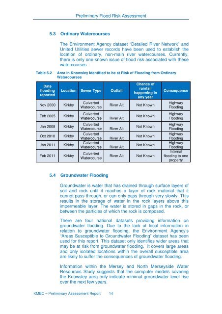
Table 5.2<br />
Date<br />
<strong>flo</strong>oding<br />
<strong>report</strong>ed<br />
Nov 2000<br />
Feb 2005<br />
Jan 2008<br />
Oct 2010<br />
Jan 2011<br />
Feb 2011<br />
5.3 Ordinary Watercourses<br />
The Environment Agency dataset “Detailed River Network” and<br />
United Utilities sewer records have been used to establish the<br />
location of ordinary, non-main river watercourses. Currently,<br />
there is only one known issue of <strong>flo</strong>od <strong>risk</strong> associated with these<br />
watercourses.<br />
Area in Knowsley Identified to be at Risk of Flooding from Ordinary<br />
Watercourses<br />
Location Sewer Type Outfall<br />
Kirkby<br />
Kirkby<br />
Kirkby<br />
Kirkby<br />
Kirkby<br />
Kirkby<br />
Culverted<br />
Watercourse<br />
Culverted<br />
Watercourse<br />
Culverted<br />
Watercourse<br />
Culverted<br />
Watercourse<br />
Culverted<br />
Watercourse<br />
Culverted<br />
Watercourse<br />
River Alt<br />
River Alt<br />
River Alt<br />
River Alt<br />
River Alt<br />
River Alt<br />
Chance of<br />
rainfall<br />
happening in<br />
any year<br />
Not Known<br />
Not Known<br />
Not Known<br />
Not Known<br />
Not Known<br />
Not Known<br />
Consequence<br />
Highway<br />
Flooding<br />
Highway<br />
Flooding<br />
Highway<br />
Flooding<br />
Highway<br />
Flooding<br />
Highway<br />
Flooding<br />
Internal<br />
<strong>flo</strong>oding to one<br />
property<br />
5.4 Groundwater Flooding<br />
Groundwater is water that has drained through surface layers of<br />
soil and rock until it reaches a layer of rock material that it<br />
cannot pass through, or can only pass through very slowly. This<br />
results in the storage of water in the rock layers above this<br />
impermeable layer. The water is stored in gaps in the rock, or<br />
between the particles of which the rock is composed.<br />
There are four national datasets providing information on<br />
groundwater <strong>flo</strong>oding. Due to the lack of local information in<br />
relation to groundwater <strong>flo</strong>oding, the Environment Agency’s<br />
“Areas Susceptible to Groundwater Flooding” dataset has been<br />
used for this <strong>report</strong>. This dataset only identifies wider areas that<br />
may be at <strong>risk</strong> from groundwater <strong>flo</strong>oding. It covers large areas<br />
and only isolated locations within the overall susceptible area<br />
are likely to suffer the consequences of groundwater <strong>flo</strong>oding.<br />
Information within the Mersey and North Merseyside Water<br />
Resources Study suggests that the computer models covering<br />
the Knowsley area only indicate minimal groundwater level rise<br />
over the next few years.<br />
KMBC – Preliminary Assessment Report 14