Annual Report 2001 - Kansas Department of Transportation
Annual Report 2001 - Kansas Department of Transportation
Annual Report 2001 - Kansas Department of Transportation

Create successful ePaper yourself
Turn your PDF publications into a flip-book with our unique Google optimized e-Paper software.
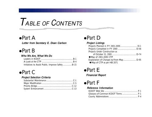
TABLE OF CONTENTS<br />
•Part A<br />
Letter from Secretary E. Dean Carlson<br />
•Part B<br />
Who We Are, What We Do<br />
Leaders in KDOT ............................................................... B-1<br />
A Look at the CTP ............................................................. B-4<br />
Initiatives to Assist Public, Improve Safety .................B-15<br />
•Part C<br />
Project Selection Criteria<br />
Substantial Maintenance.................................................... C-1<br />
Major Modification ............................................................. C-5<br />
Priority Bridge....................................................................C-12<br />
System Enhancement .......................................................C-13<br />
•Part D<br />
Project Listings<br />
Projects Planned in FY <strong>2001</strong>-2009................................. D-1<br />
Projects Completed in FY 2000 .................................... D-56<br />
Projects Under Construction as<br />
<strong>of</strong> October 31, 2000 ............................................... D-74<br />
uMap <strong>of</strong> <strong>2001</strong>-2009 CTP<br />
Explanation <strong>of</strong> Changes to/from Map......................... D-95<br />
uMap <strong>of</strong> CTP as per HB 2071<br />
•Part E<br />
Financial <strong>Report</strong><br />
•Part F<br />
Reference Information<br />
KDOT Web Site ................................................................. F-1<br />
Glossary <strong>of</strong> Common KDOT Terms .............................. F-1<br />
County Abbreviations ........................................................ F-4
A Letter From...<br />
Secretary E. Dean Carlson<br />
The <strong>Kansas</strong> <strong>Department</strong> <strong>of</strong> <strong>Transportation</strong>’s primary focus<br />
over the last year has been implementing the Comprehensive<br />
<strong>Transportation</strong> Program (CTP) that was passed by the 1999<br />
legislature. This historic ten-year program is a crucial link<br />
between the transportation needs <strong>of</strong> Kansans in the 20 th century<br />
and their transportation needs in the 21 st century.<br />
This past year saw the selection <strong>of</strong> the 29 System<br />
Enhancement projects that will substantially improve safety,<br />
relieve congestion, improve access, enhance economic<br />
development in their locations, and have a beneficial impact on<br />
the whole State Highway System.<br />
The System Enhancement project selection process may<br />
have been in the spotlight, but it was just one <strong>of</strong> the steps <strong>of</strong><br />
progress that KDOT has taken in the past year. Here are just a<br />
few examples:<br />
u the CTP-created Airport Assistance program<br />
has funded dozens <strong>of</strong> improvements at our<br />
state’s general aviation airports;<br />
u the Local Partnership Grade Separation<br />
program is giving communities another avenue<br />
to improve safety at more <strong>of</strong> our state’s<br />
railroad-highway crossings;<br />
u and cities and counties have more dollars to<br />
use for their own local projects, thanks to the<br />
increases in the Special City County Highway<br />
Fund payments authorized by the CTP.<br />
KDOT is using the funding provided by the CTP to make<br />
the transportation infrastructure <strong>of</strong> <strong>Kansas</strong> safer, more efficient,<br />
and more durable. The agency has managed to do this in the<br />
A-1
face <strong>of</strong> reductions in the sales tax demand transfer in both FY<br />
2000 (approximately $27 million) and FY <strong>2001</strong> (approximately<br />
$40 million). At the same time, KDOT has seen increased cost<br />
estimates because <strong>of</strong> higher bids, increased project scopes, and<br />
inflation. The margin between success and failure is getting<br />
thinner.<br />
This is why this coming year is a crucial one in the life <strong>of</strong> the<br />
Comprehensive <strong>Transportation</strong> Program. While KDOT will<br />
make every effort to control operating costs, erosion <strong>of</strong> funding<br />
would severely impact KDOT’s ability to complete all <strong>of</strong> the<br />
projects currently included in the Comprehensive <strong>Transportation</strong><br />
Program. It is too early to determine the ones that<br />
could be affected, but it is not too early to say that any project<br />
eliminated will have a debilitating effect on the Kansans looking<br />
forward to that project’s completion.<br />
I look forward to working with the Governor and all<br />
legislators to make sure that we stay on the path <strong>of</strong> Continued<br />
<strong>Transportation</strong> Progress that is embodied in the Comprehensive<br />
<strong>Transportation</strong> Program.<br />
Sincerely,<br />
E. Dean Carlson<br />
Secretary <strong>of</strong> <strong>Transportation</strong><br />
A-2
WHO WE ARE ...<br />
The Secretary <strong>of</strong> <strong>Transportation</strong> is responsible for<br />
coordinating the planning, development, and operation <strong>of</strong> the<br />
various modes and systems <strong>of</strong> transportation within the state.<br />
KDOT is divided into six geographical transportation districts<br />
throughout the state and has its headquarters in Topeka. The<br />
Headquarters <strong>of</strong>fices are<br />
divided into divisions, bureaus,<br />
and <strong>of</strong>fices. Each division<br />
oversees various bureaus/<br />
<strong>of</strong>fices. The Division <strong>of</strong><br />
Operations also oversees the<br />
district <strong>of</strong>fices.<br />
Leaders in KDOT<br />
We depend on<br />
our employees<br />
and business<br />
partners to get<br />
the job done.<br />
Headquarters<br />
u E. Dean Carlson,<br />
Secretary <strong>of</strong> <strong>Transportation</strong><br />
u Warren Sick,<br />
Assistant Secretary/State <strong>Transportation</strong> Engineer<br />
u Nancy Bogina,<br />
Special Assistant/Director <strong>of</strong> Public Affairs<br />
u Bob Haley,<br />
Director <strong>of</strong> Administration<br />
u Mike Armour,<br />
Director <strong>of</strong> Aviation<br />
u G. David Comstock,<br />
Director <strong>of</strong> Engineering and Design<br />
u Steve Woolington,<br />
Director <strong>of</strong> Operations<br />
u Terry Heidner,<br />
Director <strong>of</strong> Planning and Development<br />
All Division Directors can be reached at (785) 296-3566.<br />
The mailing address is KDOT, 915 Harrison,<br />
Topeka, KS, 66612-1568.<br />
KDOT’s experienced workforce has a diverse background.<br />
From civil engineers to equipment operators to <strong>of</strong>fice<br />
assistants to application programmers to engineering<br />
technicians, <strong>Department</strong> employees strive to provide the<br />
many quality services necessary for a safe and efficient<br />
transportation system in <strong>Kansas</strong>.<br />
B-1
Norton<br />
Topeka<br />
Salina<br />
Garden City<br />
Hutchinson<br />
Chanute<br />
The six KDOT Districts throughout <strong>Kansas</strong> are each headed<br />
by its own District (Chief) Engineer. District Engineers are<br />
delegated the responsibility and authority to supervise<br />
administration, construction, maintenance, and materials<br />
throughout that District. Each District is further divided into<br />
several area <strong>of</strong>fices that are headed by Area Engineers. Within<br />
each Area are Subarea <strong>of</strong>fices that primarily perform various<br />
roadway maintenance activities including snow/ice removal.<br />
B-2
B-3
What we do ...<br />
KDOT works to achieve its goal <strong>of</strong> providing a statewide<br />
transportation system to meet the needs <strong>of</strong> <strong>Kansas</strong> each and<br />
every day in many different ways. Some <strong>of</strong> the agency’s<br />
responsibilities are to:<br />
udetermine project scope, design, and let to construction<br />
between 450 to 600 state and local improvement projects a year;<br />
uidentify and study future highway traffic needs through<br />
data collection and evaluations across the state;<br />
uperform necessary road and bridge maintenance activities;<br />
uadminister federal funding, contract compliance, and<br />
inspection <strong>of</strong> material and labor;<br />
udevelop innovative materials through extensive research<br />
to lengthen the life span <strong>of</strong> roadways;<br />
uprovide resources to assist aviation, public transit, local<br />
partership, and rail crossing and service improvement activities.<br />
A LOOK AT THE COMPREHENSIVE<br />
TRANSPORTATION PROGRAM<br />
The following information describes how the<br />
Comprehensive <strong>Transportation</strong> Program (CTP) is designed and<br />
some <strong>of</strong> the programs, administrative issues, and federal<br />
transportation issues that involve the department.<br />
COMPONENTS OF THE CTP<br />
sState Highway Program<br />
sLocal <strong>Transportation</strong> Program<br />
sOther Modal Programs<br />
STATE HIGHWAY PROGRAM<br />
Highways - KDOT is responsible for maintaining the State<br />
Highway System. <strong>Kansas</strong> has the fourth largest number <strong>of</strong> public<br />
road miles <strong>of</strong> any state in the nation. The majority <strong>of</strong> the state’s<br />
public roads are not maintained by KDOT. Only about 9,600<br />
miles, or 7 percent <strong>of</strong> the total<br />
number <strong>of</strong> public road miles,<br />
are included in the State Highway<br />
System. However, the State<br />
Highway System and its 823<br />
miles <strong>of</strong> City Connecting Links<br />
(city streets which connect rural<br />
portions <strong>of</strong> the State Highway<br />
Our employees<br />
are our most<br />
valuable<br />
resource.<br />
System) carry 52 percent <strong>of</strong> the state’s total travel. The chart on<br />
page B-5 outlines highway jurisdictional responsibilities and fund<br />
B-4
sources for highway improvements.<br />
The CTP requires the <strong>Department</strong> to spend a minimum <strong>of</strong><br />
$3 million per county on highway construction improvements<br />
over the life <strong>of</strong> the program. The State Highway Program<br />
portion is divided into four main project categories: Major<br />
Modification, Priority Bridge, Substantial Maintenance, and<br />
System Enhancement. For more details about the projects and<br />
project selection, turn to Parts C and D. (Please note that all<br />
Major Modification and Priority Bridge projects for the CTP are<br />
listed as part <strong>of</strong> the Legislative record in the debate over HB<br />
2071. KDOT therefore considers these projects to be a commitment<br />
to the people <strong>of</strong> <strong>Kansas</strong>.)<br />
A description <strong>of</strong> each category follows.<br />
Substantial Maintenance<br />
The Substantial Maintenance program provides funding to<br />
preserve the “as-built” condition <strong>of</strong> <strong>Kansas</strong> highways to the best<br />
extent possible. Funds are set aside each year for pavement<br />
resurfacing programs; bridge and culvert repairs and bridge<br />
painting; and safety, signing, lighting, pavement markings,<br />
and emergency work. These projects are selected one<br />
year at a time.<br />
Major Modification<br />
Major Modification projects are designed to preserve and<br />
improve the service and safety <strong>of</strong> the existing highway system.<br />
Examples <strong>of</strong> work in this category are reconstruction and<br />
rehabilitation <strong>of</strong> pavement, widening traffic lanes, adding or<br />
HIGHWAY JURISDICTION AND RESOURCES<br />
Road Category Jurisdictional Authority Fund Sources<br />
State Highway System<br />
10,385 miles*<br />
52% <strong>of</strong> total travel<br />
Non-state highway system<br />
123,440 miles<br />
43% <strong>of</strong> total travel**<br />
KDOT<br />
Cities and<br />
Counties<br />
sState Highway Fund<br />
sFederal funds<br />
sLocal funds<br />
sSpecial City and County<br />
Highway Fund<br />
sLocal Funds<br />
sState allocated federal funds<br />
*Includes City<br />
Connecting<br />
Links.<br />
**The remaining<br />
5% <strong>of</strong> total<br />
travel is on the<br />
238-mile<br />
<strong>Kansas</strong><br />
Turnpike.<br />
B-5
widening shoulders, and eliminating steep hills or sharp<br />
curves. Associated bridge work includes widening<br />
narrow bridges, replacing obsolete bridges, and<br />
modernizing bridge rails and guard fences. In addition to<br />
major roadway and associated bridge projects, a number <strong>of</strong><br />
projects are financed with Major<br />
Modification funds set aside each year to<br />
address specific concerns such as railroad<br />
crossings, corridor managment, and other<br />
spot location improvements.<br />
Priority Bridge<br />
The Priority Bridge program provides<br />
funding to replace or rehabilitate bridges that<br />
are in a deteriorated condition or are<br />
deficient in load-carrying capacity, width,<br />
or traffic service.<br />
System Enhancement<br />
The System Enhancement Program consists <strong>of</strong> projects<br />
that substantially improve safety, relieve congestion, improve<br />
access or enhance economic development. Projects must be<br />
on the State Highway System or be a logical addition to the<br />
State Highway System.<br />
CTP authorizing legislation, House Bill 2071, specifies<br />
that $1.05 billion <strong>of</strong> state funds are to be expended or<br />
committed to be expended for the period July 1, 1999<br />
STATE HIGHWAY<br />
PROGRAM COMPONENTS<br />
<strong>of</strong> the CTP<br />
sMajor Modification<br />
sPriority Bridge<br />
sSubstantial Maintenance<br />
sSystem Enhancement<br />
through June 30, 2009, for System Enhancement projects.<br />
The bill also states that KDOT “shall utilize the selection<br />
methodology developed by the <strong>Department</strong> to select System<br />
Enhancement projects.”<br />
KDOT received about $5 billion in project requests.<br />
Local governments submitted projects for<br />
funding in one <strong>of</strong> six categories: Rural<br />
Corridor, Rural Bypass, Rural Interchange,<br />
Urban Corridor, Urban Bypass, and Urban<br />
Interchange. Projects were compared only<br />
to other projects in their category.<br />
The Economic Development Review<br />
Panel, appointed by Governor Bill Graves<br />
and chaired by Lt. Governor Gary Sherrer,<br />
reviewed and scored each project based on<br />
potential economic impact. Each project<br />
was also carefully reviewed by KDOT and<br />
given a score based on objective engineering<br />
factors such as traffic volune, safey, and design. The 29<br />
projects selected to receive System Enhancement funding<br />
were announced August 4, 2000.<br />
Construction <strong>of</strong> these projects is contingent upon funding<br />
as provided in HB 2071, the legislation creating the CTP. For<br />
a list <strong>of</strong> projects and details about project selection, turn to<br />
Part C.<br />
B-6
LOCAL TRANSPORTATION PROGRAM<br />
The Local <strong>Transportation</strong> Program portion <strong>of</strong> the CTP<br />
includes five categories: Special City and County Highway Fund;<br />
Local Federal-Aid Projects; Local Partnership Program; City<br />
Connecting Link Payments; and <strong>Transportation</strong> Enhancement. A<br />
description <strong>of</strong> each category follows:<br />
Special City and County Highway Fund<br />
State motor fuels tax revenue received<br />
through the Special City and County Highway<br />
Fund (SCCHF) is one source <strong>of</strong> transportation<br />
funds for local units <strong>of</strong> government. <strong>Annual</strong><br />
funding for the SCCHF under the CTP has been<br />
increased 37 percent compared to funding in the<br />
previous transportation program. It will now<br />
provide $160 million per year to local units <strong>of</strong><br />
government. The SCCHF is distributed directly<br />
to cities and counties quarterly by the State<br />
Treasurer.<br />
Local Federal Aid Projects<br />
Local units <strong>of</strong> government as well as the state<br />
are provided federal aid through the<br />
<strong>Transportation</strong> Equity Act for the 21st Century (TEA-21)<br />
through Federal Fiscal Year (FFY) 2003. KDOT will continue its<br />
LOCAL TRANSPORTATION<br />
PROGRAM COMPONENTS<br />
<strong>of</strong> the CTP<br />
sSpecial City and County<br />
Highway Fund<br />
sLocal Federal Aid Projects<br />
sLocal Partnership Program<br />
sCity Connecting Link<br />
Payments<br />
s<strong>Transportation</strong> Enhancement<br />
policy <strong>of</strong> sharing federal aid with local units <strong>of</strong> government.<br />
TEA-21 provided a 45 percent increase to cities and counties<br />
resulting in about $17 million per year additional funding for<br />
FFY 1998-2003. Local units <strong>of</strong> government are responsible for<br />
programming these projects.<br />
Local Partnership Program<br />
The Local Partnership Program includes three categories:<br />
City Connecting Link (KLINK) Resurfacing, Geometric<br />
Improvement, and Economic Development.<br />
Project applications are solicited from cities<br />
and counties each June.<br />
The KLINK Resurfacing Set-aside<br />
Program provides funding for resurfacing<br />
projects on City Connecting Links. KDOT<br />
funds these projects on a 75 percent state/25<br />
percent local match basis for cities with less<br />
than 10,000 population. For cities greater<br />
than 10,000 population, KDOT funds<br />
resurfacing projects on a 50/50 basis. The<br />
maximum state participation is $200,000 per<br />
project.<br />
Geometric Improvement projects help<br />
cities widen pavements and add needed<br />
turning, acceleration, and deceleration lanes on City Connecting<br />
Links. KDOT funds these projects on a 75 to 100 percent state<br />
share depending on the size <strong>of</strong> the city.<br />
B-7
Highway and bridge construction projects that enhance area<br />
economic development in <strong>Kansas</strong> are classified as Economic<br />
Development projects. KDOT funds these on a maximum <strong>of</strong> 75<br />
percent state/25 percent local match basis.<br />
City Connecting Link Payments<br />
Cities receive payments from KDOT to maintain their City<br />
Connecting Links. As a part <strong>of</strong> the CTP, payments<br />
have been increased for maintenance <strong>of</strong><br />
City Connecting Links from $2,000 per<br />
year per lane-mile to $3,000 per year<br />
per lane-mile.<br />
<strong>Transportation</strong><br />
Enhancement<br />
Federal statute requires that a<br />
minimum <strong>of</strong> 10 percent <strong>of</strong> the state’s Federal<br />
Surface <strong>Transportation</strong> Program funding be set aside for<br />
<strong>Transportation</strong> Enhancement projects. These projects fall into<br />
three categories: historic, scenic and environmental, and<br />
pedestrian and bicycle facilities and must be directly related to a<br />
surface transportation system. This program is funded based on<br />
an 80 percent federal/20 percent local match. Applications are<br />
solicited from cities and counties and evaluated based on intent<br />
<strong>of</strong> the program. In 2000, KDOT’s TE program won an Award<br />
<strong>of</strong> Excellence from the American Association <strong>of</strong> State Highway<br />
and <strong>Transportation</strong> Officials.<br />
$3 million in state funds will be<br />
appropriated to airport improvements<br />
across <strong>Kansas</strong> each year<br />
under the CTP.<br />
B-8<br />
OTHER MODAL PROGRAMS<br />
<strong>Kansas</strong> Airport Improvement Program<br />
When time is <strong>of</strong> the essence, no other means <strong>of</strong> travel can<br />
fulfill time sensitive requirements the way that air transportation<br />
does. Airports serve an important role in the state transportation<br />
system. The foremost role is the economic activity generated by<br />
existing organizations that rely on airports to enhance their<br />
business and serve new customers, as well as new<br />
firms that may be considering locating in<br />
<strong>Kansas</strong>. Equally important are medical<br />
services, both fly-in by pr<strong>of</strong>essionals<br />
and emergency evacuations. Additionally,<br />
agricultural application, charter,<br />
and private air travel, and the link to the<br />
national air transportation system and<br />
many other services are only available because <strong>of</strong><br />
airports.<br />
Prior to the CTP, the only nonlocal assistance for airport<br />
improvement in <strong>Kansas</strong> was provided by the federal government<br />
through the Federal Aviation Administration’s Airport<br />
Improvement Program (AIP) that yearly assisted less than 5<br />
percent <strong>of</strong> the 132 public-use general aviation airports in <strong>Kansas</strong>.<br />
Today, the <strong>Kansas</strong> Airport Improvement Program’s $3 million a<br />
year in state funds, along with local matching funds, results in an<br />
estimated $4 to $4.5 million in improvements.<br />
The goals <strong>of</strong> the <strong>Kansas</strong> Airport Improvement Program
Fiscal Year 2000, <strong>2001</strong> Airport Improvement Locations in <strong>Kansas</strong><br />
2<br />
3<br />
3<br />
2<br />
1<br />
2 2 2 5 4<br />
5 3<br />
3<br />
2 2<br />
5<br />
6<br />
3<br />
2<br />
2<br />
6 2<br />
2<br />
2<br />
5<br />
2<br />
4<br />
2<br />
6<br />
6<br />
2<br />
2<br />
2<br />
3<br />
4<br />
2<br />
6 5<br />
5<br />
2<br />
5<br />
5<br />
2<br />
4<br />
6 5<br />
6<br />
5<br />
5<br />
6<br />
1 6<br />
3<br />
3<br />
2<br />
TYPES OF IMPROVEMENTS<br />
1 New runway<br />
3<br />
Crack sealing or slurry coat<br />
5<br />
Marking, lighting, Navigation/Communication projects<br />
2<br />
Runway rehabilitation<br />
4<br />
Taxiway and ramp improvement<br />
6<br />
Automated weather reporting<br />
B-9
include:<br />
uImproving the systems runway condition rating to “very<br />
good;”<br />
uMinimizing surface travel time to air ambulance pick-up<br />
locations;<br />
uIncreasing safety by improvements to taxiways, ramps, and<br />
lighting;<br />
uEnhancing community economic development<br />
appeal.<br />
The state/sponsor match is determined by<br />
the sponsor’s population. Sponsors with a<br />
population <strong>of</strong> less than 10,000 will participate at<br />
a 75 percent state/25 percent sponsor match<br />
rate. Sponsors with a population that is greater<br />
than 10,000 will participate at a 50 percent state/<br />
50 percent sponsor match rate.<br />
In the first two years, the program provided funding to 48<br />
public-use airports. These projects are illustrated on page 9. The<br />
projects included: construction <strong>of</strong> all new runways; runway<br />
rehabilitation and/or extension; crack sealing and slurry coats;<br />
construction or rehabilitation or taxiways or ramps; lighting,<br />
communication or navigation systems; and installation <strong>of</strong> Automated<br />
Weather <strong>Report</strong>ing Systems.<br />
Rail Service Improvement Fund<br />
Many areas <strong>of</strong> the state no longer have service from Class I<br />
railroads. Shortline railroads provide rail service to such areas<br />
KDOT vision:<br />
To be the best<br />
in everything<br />
we do.<br />
B-10<br />
and provide an alternative to the truck for freight (primarily<br />
grain) shippers. This alternative provides competition and helps<br />
keep shipping rates down. In addition, it reduces the number <strong>of</strong><br />
trucks that would otherwise be on <strong>Kansas</strong> roads and highways.<br />
This in turn avoids increased maintenance and rehabilitation<br />
costs for those roads.<br />
Prior to the CTP, KDOT had been operating a small revolving<br />
loan program with federal dollars that are used<br />
for track rehabilitation. There were no state funds<br />
available for rail projects.<br />
The Rail Service Improvement Fund component<br />
<strong>of</strong> the CTP will receive $3 million per year<br />
for eight years and will be administered by<br />
KDOT’s Rail Affairs section. The fund makes<br />
available to shortline railroads operating in<br />
<strong>Kansas</strong> low-interest, long-term (ten-year) loans to<br />
be used primarily for track rehabilitation projects. Loans may<br />
also be used for financing and acquisition activities.<br />
It is anticipated that at the end <strong>of</strong> this eight-year period the<br />
Rail Service Improvement Fund will become self-sustaining<br />
allowing shortline railroads ongoing opportunities to improve<br />
their systems, enhance service to customers, and have a positive<br />
impact on the economy <strong>of</strong> the state.<br />
Criteria for projects selected and loans made within the Rail<br />
Service Improvement Fund loan program are:<br />
uThe ratio <strong>of</strong> benefits to costs for any project must be<br />
greater than one. The benefit/cost methodology used to
determine the benefit/cost ratio is the most recent standard<br />
benefit/cost methodology approved by the Federal Railroad<br />
Administration (FRA) <strong>of</strong> the United States <strong>Department</strong> <strong>of</strong><br />
<strong>Transportation</strong>.<br />
uThe qualified entity shall demonstrate that adequate<br />
funding for the proposed project is not otherwise available on<br />
terms that would make the proposed project financially feasible<br />
in the absence <strong>of</strong> a low-interest state loan.<br />
uThe qualified entity must average more than 20 carloads<br />
per mile during the past year <strong>of</strong> operation, but haul less than<br />
5,000,000 gross-ton miles per mile annually.<br />
uThe qualified entity shall demonstrate that<br />
operations will be made more efficient by raising<br />
the minimum operating speed from FRA Class<br />
One (up to 10 mph) to FRA Class Two (10-25<br />
mph) or FRA Class Two to FRA Class<br />
Three (25-39 mph).<br />
uThe qualified entity shall agree not<br />
to seek abandonment <strong>of</strong> ten years following<br />
completion <strong>of</strong> the rehabilitation project.<br />
uThe qualified entity shall demonstrate a<br />
positive regional or statewide economic impact as<br />
a result <strong>of</strong> the rehabilitation project.<br />
During FY 2000, five shortline railroads used the Rail<br />
Service Improvement Fund loan program to undertake six<br />
rehabilitation projects. These projects included the replacement<br />
<strong>of</strong> ties, ballast, rail, anchors, and spikes in 14 counties across the<br />
Under the CTP, $6 million a<br />
year will be available in<br />
the state program to<br />
provide services.<br />
B-11<br />
state. It is anticipated that six more rehabilitation projects will be<br />
launched during FY <strong>2001</strong> with the bulk <strong>of</strong> the work focused on<br />
the replacement <strong>of</strong> ties, ballast, rail, anchors, and spikes.<br />
Public Transit<br />
One state and two federal public transit programs provide<br />
services to the citizens <strong>of</strong> <strong>Kansas</strong> who depend upon public<br />
transportation. Without these programs, many citizens would<br />
have no way to make medical appointments, hold a job, shop, or<br />
be self-sufficient.<br />
Federal Transit Administration (FTA) 49 U.S.C. 5311<br />
provides federal monies to support nonurban area<br />
(under 50,000 population) transportation<br />
programs that serve elderly persons and<br />
persons with disabilities while also providing<br />
the general public with an equal<br />
opportunity to utilize the services. The<br />
program augments existing<br />
transportation services and enhances<br />
access for participants. About $3 million is<br />
available yearly to <strong>Kansas</strong> under this program.<br />
FTA 49 U.S.C. 5310 provides federal monies<br />
to private nonpr<strong>of</strong>it corporations and associations<br />
or public bodies approved by the state to purchase vehicles and<br />
related equipment to meet the special transportation needs <strong>of</strong><br />
elderly persons and persons with disabilities. Urbanized areas<br />
and nonurban areas under 50,000 population are eligible. About
$792,000 is available yearly to <strong>Kansas</strong> under this program.<br />
Funding for the state program is available from the Elderly<br />
& Disabled Coordinated Public <strong>Transportation</strong> Assistance<br />
Fund. Under the CTP, the state program has been increased to<br />
$6 million a year from $1 million to provide needed transportation<br />
in areas <strong>of</strong> the state lacking service and to expand and<br />
enhance existing services. In addition, KDOT is providing the<br />
state program with an additional $1 million per year <strong>of</strong> Federal<br />
Surface <strong>Transportation</strong> Program funds for three years to jump<br />
start the much needed replacement <strong>of</strong> public transit vehicles.<br />
During FY 2000, the state program provided a total <strong>of</strong><br />
$3.77 million to the urban transit authorities in Topeka,<br />
Lawrence, Wichita, Johnson County, and the Unified Government<br />
<strong>of</strong> Wyandotte County/<strong>Kansas</strong> City, <strong>Kansas</strong>. Rural transit<br />
providers received $3.23 million in FY 2000. They will receive<br />
similar amounts in FY <strong>2001</strong>.<br />
The urban transit authorities used the funds for expanding<br />
and enhancing service by adding new routes, longer hours <strong>of</strong><br />
operation, more service on weekends, and increased para transit<br />
service. Steps were taken to begin publicly-funded transit service<br />
in Lawrence for the first time. Some urban agencies chose to<br />
carry over a portion <strong>of</strong> their funds to save for very large capital<br />
expenditures in future years.<br />
Rural providers also expanded and enhanced service by<br />
extending hours, adding weekend service, and running more<br />
routes. Also, a major new transit service began in Reno County.<br />
Project selection criteria include:<br />
uIdentification <strong>of</strong> needs – demand for service, number <strong>of</strong><br />
people in service area, type <strong>of</strong> trips.<br />
uUtilization <strong>of</strong> services – service indicators such as vehicle<br />
service per week, average miles per month per vehicle, etc.;<br />
passenger type statistics; cost indicators.<br />
uCoordination <strong>of</strong> services – coordination with other<br />
providers within the proposed service area.<br />
uAccessibility, safety, and training – accessibility <strong>of</strong> project<br />
vehicles and compliance with Americans with Disabilities Act<br />
criteria, awareness <strong>of</strong> trip needs <strong>of</strong> the disabled, training <strong>of</strong><br />
drivers and other personnel.<br />
uFinancial management capability – qualifications/<br />
experience in managing grants, past performance <strong>of</strong> KDOT<br />
contract activities.<br />
uLocal commitment to transit – financial support from<br />
local government, participating in local transportation planning.<br />
FUNDING<br />
The <strong>Department</strong> is funded with revenue from a<br />
combination <strong>of</strong> sources that include motor fuel taxes, vehicle<br />
registration fees, sales tax, and bond proceeds and are<br />
supplemented by federal-aid and local funds in some<br />
categories.<br />
Current revenue projections are based on estimates from<br />
the State Consensus and Highway Revenue Estimating<br />
Groups and current statutes. Estimated motor fuel tax<br />
B-12
B-13
collections were down from previous consensus estimates for<br />
both gasoline and diesel. Future growth is expected to be<br />
minimal. Registration fees have been strong because <strong>of</strong> the<br />
economy, but future increases are expected to be less than 2<br />
percent per year. Sales tax projections are down for FY <strong>2001</strong> and<br />
FY 2002 reflecting a flattening <strong>of</strong> the economy. Future growth<br />
was revised downward slightly.<br />
The sales tax transfers for FY 2000 and FY <strong>2001</strong> were<br />
reduced by $27.2 million and $39.2 million respectively from the<br />
statutory amounts during the 2000 Legislative Session. These<br />
reductions were part <strong>of</strong> an overall financing plan to manage a<br />
temporary shortfall in the State General Fund.<br />
The long-term interest and inflation rate projections used in<br />
KDOT’s estimates have been changed from those used in the<br />
2000 <strong>Annual</strong> <strong>Report</strong> due to changes in projections by the estimating<br />
groups.<br />
In November and December 2000, the <strong>Department</strong> sold<br />
$350 million <strong>of</strong> the $995 million in bonds authorized by the<br />
CTP. The <strong>Department</strong> had sold $325 million in bonds in 1999<br />
and anticipates selling the remaining $320 million in FY 2002.<br />
In general, KDOT expects to receive less revenue and have a<br />
lower ending cash balance at the end <strong>of</strong> the CTP than previously<br />
reported.<br />
The revenue estimates are down compared to last year’s for<br />
two primary reasons. First, the estimating groups have adjusted<br />
their estimates downward to reflect current economic trends and<br />
these estimates are used in KDOT’s projections. (Details on the<br />
estimates are included in Part E - Financial Compliance.) Also,<br />
the $66.4 million reduction in the sales tax transfer noted above<br />
is now reflected in KDOT’s estimates. These were not accounted<br />
for in last year’s report because the decision to reduce the<br />
transfer was made after the report was published. In addition,<br />
this report is based on statutory sources and estimates and does<br />
not take into consideration either the Governor’s budget<br />
recommendations or <strong>2001</strong> legislative actions.<br />
The revised estimates and the $66.4 million reduction in sales<br />
tax transfer had a negative impact on the estimated ending cash<br />
balances compared to last year’s report. Less revenue means less<br />
money to begin with and thus, less money at the end. A third<br />
$1,200<br />
$1,000<br />
$800<br />
$600<br />
$400<br />
$200<br />
$0<br />
Millions<br />
CTP State Revenues – All Funds<br />
<strong>Kansas</strong> <strong>Department</strong> <strong>of</strong> <strong>Transportation</strong><br />
00 01 02 03 04 05 06 07 08 09 10<br />
Fiscal Year<br />
At time <strong>of</strong> 99 HB2071 December 99 Est FY 2000 Actual, November 2000 Est.<br />
Excludes Federal Aid, Local Funds and Bonding.<br />
B-14
factor is also tugging at the ending balance and that is an increase<br />
in estimated expenditures.<br />
When KDOT made its initial projections for the CTP, the<br />
expenditure estimates were based on what was known about the<br />
anticipated projects at the time, and project development had<br />
only just begun on the majority <strong>of</strong> the projects. Since then,<br />
KDOT has been able to further investigate and research the<br />
projects as detailed project design has progressed. Based on this<br />
improved information, KDOT has refined its project estimates<br />
and in many cases these estimates are higher than the initial<br />
estimates.<br />
The chart on B-14 and the chart at right illustrate the projected<br />
state revenues and ending cash balances, comparing<br />
current estimates to those made last year and those made when<br />
the CTP was passed (spring 1999). The <strong>Department</strong> continues<br />
to estimate available Federal Highway Trust Funds at 90 percent<br />
<strong>of</strong> apportioned funds. It is important to note that much <strong>of</strong> the<br />
State Highway Fund’s revenue sources are not inflation sensitive.<br />
The sales tax is the only source that increases due to inflation.<br />
Conversely, most <strong>of</strong> KDOT’s expenditures are very sensitive<br />
to inflation, which means that the amount <strong>of</strong> work that can be<br />
done for the same amount <strong>of</strong> money is reduced over time.<br />
The ending cash balances chart at right does show increases<br />
in the early years <strong>of</strong> the program, compared to the estimates in<br />
last year’s report. This reflects the shifting <strong>of</strong> federal aid towards<br />
the front <strong>of</strong> the program as well as the proceeds from bond<br />
sales. However, this cannot be interpreted as an increase in the<br />
Millions<br />
$1,000<br />
$900<br />
$800<br />
$700<br />
$600<br />
$500<br />
$400<br />
$300<br />
$200<br />
$100<br />
$0<br />
-$100<br />
CTP Ending Cash Balances – All Funds<br />
<strong>Kansas</strong> <strong>Department</strong> <strong>of</strong> <strong>Transportation</strong><br />
00 01 02 03 04 05 06 07 08 09 10<br />
Fiscal Year<br />
Ending Balances have been<br />
reduced to reflect the<br />
minimum required to meet<br />
debt service and operating<br />
cash flow requirements.<br />
At time <strong>of</strong> 99 HB2071 December 99 Est FY 2000 Actual, November 2000 Est.<br />
* Assumes continued matching <strong>of</strong> Federal Aid, Substantial Maintenance, & Agency Operations beyond FY 2009.<br />
amount <strong>of</strong> money available for the ten-year program. These<br />
funds are required in future years, both within and outside the<br />
ten-year period, to pay for the completion <strong>of</strong> projects already<br />
committed to in the CTP.<br />
Based on information available at the time <strong>of</strong> this report’s<br />
publication, the Secretary is hopeful that the projects committed<br />
to in the CTP can be completed. However, it is imperative to<br />
note that there are no excess revenues in this program, and the<br />
<strong>Department</strong> will be required to carefully manage the available<br />
funds to ensure successful completion <strong>of</strong> the CTP. The margin<br />
between success and failure is getting thinner.<br />
B-15
INITIATIVES TO ASSIST PUBLIC,<br />
IMPROVE SAFETY<br />
ROAD CONDITION REPORTING SYSTEM<br />
The Road Condition <strong>Report</strong>ing System (RCRS) is an<br />
information system used to collect and disseminate current<br />
weather-related conditions along the approximately 10,000 miles<br />
<strong>of</strong> state-maintained highways in <strong>Kansas</strong>. RCRS utilizes Internet/<br />
Intranet and Geographic Information System (GIS) technologies<br />
to allow entry and update <strong>of</strong> conditions from 26 KDOT maintenance<br />
<strong>of</strong>fices as the conditions occur. The public was able to<br />
access the GIS map for the first time in winter 2000 on KDOT’s<br />
web site at kanroad.org and view a map showing real-time<br />
weather-related road conditions.<br />
Internet and GIS technologies have provided opportunities<br />
for significant improvements in the efficiency <strong>of</strong> reporting road<br />
conditions to the <strong>Kansas</strong> traveler. The project also has created<br />
cost savings in fax technology s<strong>of</strong>tware cost by using only one<br />
application on the web server, collection <strong>of</strong> Snow and Ice<br />
Performance Data (SNICE), and availability <strong>of</strong> real-time inforhttp://kanroad.org<br />
mation to the public. It is the first KDOT interactive web site.<br />
RCRS will complement the Road Condition Hot Line for road<br />
conditions.<br />
The next project involving RCRS will be the Construction<br />
Detour <strong>Report</strong>ing system. It will place Planned Construction<br />
Projects on a GIS map linked to the RCRS map.<br />
ROAD CONDITION HOT LINE<br />
KDOT and the <strong>Kansas</strong> Highway Patrol have operated the<br />
toll-free Road Condition Hot Line since January 1995. It<br />
provides travelers information on how the weather is affecting<br />
road conditions and about construction detours and restrictions.<br />
KHP dispatchers update the weather information as needed.<br />
KDOT’s Office <strong>of</strong> <strong>Transportation</strong> Information updates the<br />
construction detour information on a weekly basis.<br />
KDOT upgraded the system last year so it can handle an<br />
influx <strong>of</strong> hot line calls, especially in inclement weather. The phone<br />
number is 1-800-585-ROAD (7623).<br />
B-16
WORK ZONE SAFETY<br />
KDOT continues its efforts to reduce highway work zone accidents<br />
and fatalities. Those efforts included taking part in National<br />
Work Zone Safety Awareness Week in April. Information distributed<br />
across the state pointed out that the victims <strong>of</strong> highway work<br />
zone accidents are usually not the highway workers, but the motorists.<br />
The safety events resulted in solid, positive media coverage<br />
across the state. KDOT reinforced the message by once again airing<br />
its “Give ‘Em A Brake” and “Get the Picture, Listen to the<br />
Signs” public service advertisements on radio and television stations.<br />
The agency also continued funding a program that pays overtime<br />
and mileage for <strong>of</strong>f-duty <strong>Kansas</strong> Highway Patrol troopers to<br />
provide extra enforcement in highway work zones.<br />
In 1999, a total <strong>of</strong> 1,627 accidents happened<br />
in highway work zones. As with accidents<br />
on any segment <strong>of</strong> the State<br />
Highway System, most <strong>of</strong> them resulted<br />
only in property damage- 1,139<br />
(about 70 percent). However, 13 <strong>of</strong><br />
the accidents (less than one percent)<br />
killed 14 people. Of those 14 people killed, only one was a highway<br />
worker. The other 13 were motorists. The remaining 475 accidents<br />
(about 29 percent) injured 747 people. Work zone accidents<br />
generally occurred between 7 a.m. and 6 p.m. with most accidents<br />
taking place between 4 p.m. to 5 p.m. The month <strong>of</strong> June had the<br />
most accidents with a total <strong>of</strong> 191.<br />
1-877-550-KDOT (5368)<br />
onnection<br />
B-17<br />
KDOT remains committed to further reducing the number <strong>of</strong><br />
accidents in highway works zones by continuing its two-fold approach<br />
<strong>of</strong> enforcement and education.<br />
PUBLIC INVOLVEMENT<br />
Public Involvement continues to be a priority for the agency.<br />
KDOT’s Public Involvement Plan aims to expand the public’s<br />
role in the decision-making process and develop better overall<br />
relationships with customers. The Public Involvement Administrator<br />
oversees the statewide program, two Headquarters Public<br />
Involvement Liaisons assist with project-specific public involvement<br />
efforts, and six District Public<br />
Involvement Liaisons are stationed<br />
around the state to coordinate local<br />
public involvement activities.<br />
KDOT has made a number <strong>of</strong><br />
significant advances in the public involvement<br />
arena in the last year including a toll-free<br />
customer service line called KDOT Connection. This number,<br />
1-877-550-KDOT (5368), automatically routes callers to the<br />
district headquarters closest to them. This allows local KDOT<br />
employees to address local issues, and helps the agency decentralize<br />
its communication processes.<br />
Public involvement also continues to gain momentum in the<br />
project-specific arena as well as at the local level. The Public<br />
Involvement Liaisons for Headquarters are always looking
for ways to get early and continuous input<br />
from the public. They use avenues like<br />
project work groups, public meetings,<br />
project newsletters, telephone calls<br />
and meetings with the public, and<br />
news media interaction. The District<br />
Public Involvement Liaisons do an<br />
extensive amount <strong>of</strong> public involvement<br />
at the grassroots level. Efforts<br />
like booths at county fairs, small<br />
group meetings with land and business<br />
owners, contact with local <strong>of</strong>ficials,<br />
and interaction with news media<br />
are just a few examples.<br />
300<br />
250<br />
200<br />
150<br />
100<br />
50<br />
Vehicle/Rail Crashes<br />
265 263 264<br />
205<br />
193<br />
172 173<br />
154 157<br />
125<br />
104 110 114 108 101<br />
90 90<br />
94<br />
87<br />
75<br />
90<br />
51<br />
70<br />
HIGHWAY/RAIL SAFETY<br />
CROSSING PROGRAMS<br />
0<br />
1977 1980 1983 1986 1989 1992 1995<br />
1999<br />
KDOT has five programs to improve safety at crossings<br />
including two new programs initiated during the CTP - Local<br />
Partnership Grade Separations and Railroad Crossing Surfacing.<br />
The Local Partnership Grade Separations program<br />
addresses highway/rail at-grade crossings <strong>of</strong>f the State Highway<br />
System as well as crossings on the State Highway System that are<br />
on lower priority routes. The Railroad Crossing Surfacing<br />
program will be for at-grade highway/railroad crossing<br />
approaches and surface upgrades.<br />
These programs, along with the existing three safety<br />
programs (Railroad/Highway Crossing projects, <strong>Kansas</strong><br />
Corporation Commission projects, and Railroad Grade<br />
Separations), work together to improve safety for motorists and<br />
have proven to be effective. While vehicle and train traffic have<br />
increased dramatically, the graph on the previous page shows<br />
substantial progress in safety through a continued reduction in<br />
B-18
accidents. These safety programs, along with the educational<br />
effort by <strong>Kansas</strong> Operation Lifesaver (a nationwide, nonpr<strong>of</strong>it<br />
public information program dedicated to reducing accidents at<br />
highway rail crossings and on railroad right <strong>of</strong> way), have<br />
increased rail safety in <strong>Kansas</strong>.<br />
ITS<br />
Intelligent <strong>Transportation</strong> Systems (ITS) utilize advanced<br />
technologies, including computer, communications, and process<br />
control technologies, to improve the efficiency, capacity, and safety<br />
<strong>of</strong> the transportation system.<br />
Design work is proceeding between KDOT and the Missouri<br />
DOT to develop ITS in the <strong>Kansas</strong> City metropolitan area. Wichita<br />
has completed an ITS Early Deployment Study that recommends<br />
ITS technologies and programs to benefit all agencies in the city<br />
and county. Development <strong>of</strong> a joint-use traffic operations center<br />
in Wichita will be the cornerstone <strong>of</strong> the future transportation management<br />
system there.<br />
KDOT’s ITS <strong>of</strong>fice continues to work closely with neighboring<br />
states to cooperate on joint ventures, share information, and<br />
coordinate activities. A four-state group has been formed involving<br />
<strong>Kansas</strong>, Iowa, Missouri and Nebraska that will strive to adhere<br />
to these principles. An ITS Steering Committee was created in<br />
1997 to direct the use <strong>of</strong> ITS to improve the state transportation<br />
system. Membership is made up <strong>of</strong> representatives from various<br />
bureaus within KDOT and from outside agencies.<br />
PARTNERING<br />
The Partnering Program plays an important role in the<br />
completion <strong>of</strong> construction projects. The process brings together<br />
two organizations (normally KDOT and a contractor) to<br />
work as a team and achieve mutually beneficial goals. It focuses<br />
on cooperation and problem solving, and it creates win-win<br />
situations with both participants dealing with one another as true<br />
partners. Partnering will be a critical factor in the successful<br />
administration and completion <strong>of</strong> the CTP.<br />
KDOT and the <strong>Kansas</strong> Contractors Association have had an<br />
“Excellence in Partnering” awards program for a number <strong>of</strong><br />
years to recognize projects where the partnering process was<br />
utilized effectively. Starting this year, nominations were made for<br />
projects in each <strong>of</strong> KDOT’s six districts. One project per district<br />
was selected to receive an award with presentations made in each<br />
district to allow contractors’ personnel as well as KDOT’s field<br />
employees to be recognized for their achievements.<br />
MOTORIST ASSISTANCE PROGRAM<br />
About 60 percent <strong>of</strong> all congestion on urban highways is<br />
caused by vehicle accidents and breakdowns causing delays that<br />
average 45 to 90 minutes. KDOT and the <strong>Kansas</strong> Highway<br />
Patrol established the Motorist Assistance Program to provide<br />
aid to motorists and assist in traffic incident management.<br />
B-19
The program protects and assists stranded motorists,<br />
provides highway incident congestion management, assists<br />
KDOT and local law enforcement agencies in preventing<br />
incidents that endanger motorists and disrupt normal traffic<br />
flow, and frees troopers to perform duties requiring law<br />
enforcement powers. In FY 2000, services were rendered to<br />
14,921 motorists.<br />
CORRIDOR MANAGEMENT<br />
Corridor management combines right <strong>of</strong> way protection<br />
and access management. It involves using measures to prevent<br />
or minimize development within the right <strong>of</strong> way <strong>of</strong> a<br />
planned improvement or future corridor and to preserve the<br />
safety and operational efficiency <strong>of</strong> existing facilities. Critical<br />
corridors have been identified in all six Districts and access<br />
master plans developed in conjunction with local <strong>of</strong>ficials.<br />
Approximately 12 corridor projects have been approved on<br />
qualifying corridors.<br />
Without the ability to set aside right <strong>of</strong> way for transportation<br />
corridors, these corridors may be lost to development.<br />
This delays project development and increases the costs <strong>of</strong><br />
improvements. A corridor could also be forced into a more<br />
environmentally sensitive area, increasing environmental<br />
damage as well as cost.<br />
Research into the associated costs <strong>of</strong> access-related<br />
accidents has also taken place as shown in the graph above.<br />
ASSOCIATED COSTS<br />
<strong>of</strong> Access-Related Accidents in <strong>Kansas</strong><br />
(1995, 1996, 1997)<br />
155,000,000<br />
145,000,000<br />
135,000,000<br />
125,000,000<br />
From January 1, 1995, to December 31, 1997, the associated<br />
costs <strong>of</strong> accidents positively related to access exceeded $100<br />
million each year. The Federal Highway Administration, with the<br />
authorization <strong>of</strong> TEA-21, has placed greater emphasis on<br />
preserving existing capacity rather than creating new capacity.<br />
RESEARCH<br />
150,052,402<br />
149,212,475<br />
1995 1996 1997<br />
132,336,147<br />
The <strong>Department</strong> is actively engaged in research and<br />
development activities both nationally and at the state level.<br />
Each year new technologies from national and state research<br />
programs are evaluated and implemented into routine practice.<br />
Several KDOT innovations have been adopted by other states.<br />
At the request <strong>of</strong> Congress in TEA-21, a national committee has<br />
been appointed, including Secretary E. Dean Carlson, to<br />
B-20
determine the goals, purposes, research agenda and projects,<br />
administrative structure, and fiscal needs <strong>of</strong> a new strategic<br />
highway research program.<br />
significantly increased the numbers to certify (see graph on B-20).<br />
This new program aids both contractor and KDOT in understanding<br />
how materials impact the process and how better to<br />
utilize the materials.<br />
NATIONAL QUALITY INITIATIVE<br />
One <strong>of</strong> the steps taken to meet KDOT’s National Quality<br />
Initiative for longer lasting pavements involves the restructuring<br />
<strong>of</strong> the Certified Inspector Training (CIT) Program. The former<br />
program focused on teaching fundamentals <strong>of</strong> inspection and<br />
testing.<br />
The new Certified Inspection and Testing Training (CIT 2 )<br />
Program is taking KDOT into the 21 st century with better<br />
trained personnel to monitor the materials used on projects.<br />
Part <strong>of</strong> the new CIT 2 Program requires a higher standard for<br />
individuals who perform testing and inspection<br />
roles. Certified testers help to minimize<br />
variance due to sampling and testing that<br />
permits the focus to be directed at the<br />
variability <strong>of</strong> the material being produced. 800<br />
Higher standards are necessary under<br />
KDOT’s Quality Control/Quality Assurance<br />
(QU/QA) specifications. The specifi-<br />
600<br />
cations require contractors to perform the 400<br />
QC testing and KDOT representatives<br />
perform verification testing. Adding 200<br />
contractors to the training program has<br />
B-21<br />
K-TRAN<br />
Number <strong>of</strong> participants in<br />
2<br />
CIT/CIT program<br />
479<br />
484<br />
CIT ‘98 CIT ‘99 CIT ‘00<br />
The <strong>Kansas</strong> <strong>Transportation</strong> and New Developments (K-<br />
Tran) Program is a joint venture between KDOT, <strong>Kansas</strong> State<br />
University, and the University <strong>of</strong> <strong>Kansas</strong> to meet the<br />
transportation research needs <strong>of</strong> <strong>Kansas</strong> by utilizing the<br />
pr<strong>of</strong>essional, academic, and research resources <strong>of</strong> all the<br />
involved groups. This ongoing, comprehensive research<br />
program is funded by KDOT and reached its ten-year milestone<br />
in August 2000.<br />
Projects are jointly developed based<br />
on ideas received from KDOT staff,<br />
local government <strong>of</strong>ficials, faculty, and<br />
industry. Seventeen projects were funded<br />
last year, and more than $81 million <strong>of</strong><br />
benefits have been determined through<br />
analysis <strong>of</strong> 64 products and procedures<br />
being put into use from the program.<br />
Additional benefits include faculty and<br />
students gaining experience and<br />
knowledge <strong>of</strong> KDOT and<br />
2<br />
transportation issues.<br />
776
PROJECT SELECTION CRITERIA<br />
The Fiscal Year (FY) 2000-2009 Comprehensive<br />
<strong>Transportation</strong> Program (CTP) has four program categories that<br />
were originally established by the FY 1990 - 1997<br />
Comprehensive Highway Program: Substantial Maintenance;<br />
Major Modification; Priority Bridge; and System Enhancement.<br />
Within each <strong>of</strong> these major categories are funding and/or<br />
project-type subcategories. The selection criteria used in<br />
developing projects are tailored to the intent and funding<br />
constraints <strong>of</strong> each program component.<br />
SUBSTANTIAL MAINTENANCE<br />
Substantial Maintenance projects, the first major<br />
component, are intended to protect the traveling public and the<br />
public’s investment in its highway system by preserving the “as<br />
built” condition as long as possible. These projects are financed<br />
with funds that are reserved (or set aside) for specific purposes.<br />
Without proper maintenance, the cost for major repairs<br />
and/or replacement at a later date can be several times greater<br />
than the cost <strong>of</strong> timely maintenance. The Substantial<br />
Maintenance set-aside funds include Non-Interstate Resurfacing,<br />
Interstate Resurfacing, City Connecting Link (KLINK)<br />
Resurfacing, Contract Maintenance, Safety Projects, Emergency<br />
Repair, Bridge and Culvert Repair, Bridge Painting, Signing,<br />
Pavement Marking, and Lighting.<br />
Non-Interstate Resurfacing<br />
Approximately 1,200 to 1,400 miles <strong>of</strong> two-lane non-<br />
Interstate pavement are resurfaced or repaired annually through<br />
this set-aside program. The program’s intent is to maintain non-<br />
Interstate pavements in adequate condition and keep rideability<br />
at an acceptable level.<br />
These projects are selected by using the Pavement<br />
Management System (PMS). PMS is an integrated set <strong>of</strong><br />
procedures that were developed by KDOT and Woodward-<br />
Clyde Consultants. It recommends pavement maintenance and<br />
rehabilitation strategies on both a network and a project level.<br />
PMS consists <strong>of</strong> three interconnected subsystems:<br />
The Pavement Management Information System (PMIS) is<br />
a data base which contains network and project level survey<br />
results, information downloaded from the planning database,<br />
and output from the Construction Priority System. Information<br />
from the planning database includes data on geometric features,<br />
traffic, and truck load information. Information is regularly<br />
transferred between these multiple data sources.<br />
The Network Optimization System (NOS) models the<br />
highway network and determines the action for each one-mile<br />
C-1
segment <strong>of</strong> the entire<br />
system to produce the<br />
optimal statewide<br />
benefit. The system can<br />
operate in either a<br />
“desired- performance”<br />
mode or a “fixedbudget”<br />
mode. In the<br />
desired- performance<br />
mode, the system selects<br />
actions to achieve the<br />
selected performance<br />
level at the lowest cost.<br />
In the fixed-budget<br />
mode, the system selects<br />
the set <strong>of</strong> projects that<br />
produces the “best” total<br />
system performance for<br />
SUBSTANTIAL<br />
MAINTENANCE<br />
COMPONENTS<br />
sNon-Interstate Resurfacing<br />
sInterstate Resurfacing<br />
sKLINK Resurfacing<br />
sContract Maintenance<br />
sSafety Projects<br />
sEmergency Repair<br />
sBridge and Culvert Repair<br />
sBridge Painting<br />
sSigning<br />
sPavement Marking<br />
sLighting<br />
the fixed-budget level. A linear programming model is used to<br />
minimize the long-term expected average cost <strong>of</strong> rehabilitation,<br />
subject to certain short-term requirements.<br />
The Project Optimization System (POS) serves two<br />
functions. First, it is a comprehensive design system for<br />
pavement structural sections on new grades. Second, it utilizes<br />
site-specific cost and material parameters to revise tentative<br />
project scopes from the NOS. Alternative rehabilitation<br />
strategies for a single project, or for groups <strong>of</strong> projects which<br />
meet cost and performance constraints from the NOS, are<br />
further evaluated. The POS selects the strategy which<br />
minimizes the need for future maintenance.<br />
Program development is a two-part process. Part One<br />
develops scopes for resurfacing projects for the year following<br />
the pavement survey. The locations <strong>of</strong> these projects will have<br />
been selected in the previous year. Part Two selects “locations<br />
only” for projects to be let to contract two years following the<br />
survey year.<br />
Interstate Resurfacing<br />
Approximately 40 lane miles <strong>of</strong> divided Interstate<br />
roadway (80 miles <strong>of</strong> two-lane pavement) are resurfaced or<br />
repaired annually through the Interstate Resurfacing set-aside<br />
program. Input from the Pavement Management System is<br />
used to decide which sections <strong>of</strong> Interstate are to be resurfaced.<br />
City Connecting Link “KLINK” Resurfacing<br />
This is a Local Partnership Program. The KLINK<br />
Resurfacing set-aside program provides funding for<br />
resurfacing projects on city streets that connect two rural<br />
portions <strong>of</strong> state highway (called City Connecting Links). These<br />
projects are funded under a 50 percent state/50 percent city<br />
funding matching arrangement for cities with greater than<br />
10,000 population and a 75 percent state/25 percent city ratio<br />
for cities with less than 10,000 population. The maximum state<br />
share for a project is $200,000.<br />
C-2
KDOT annually solicits requests for eligible projects. All<br />
State Highway System City Connecting Links are eligible except<br />
those on the Interstate System and fully controlled access sections<br />
on the Freeway System. Cities requesting projects are<br />
encouraged to review the proposed projects with the KDOT<br />
District Engineer or designated representative before submitting<br />
applications. If requested funds exceed available funds, projects<br />
are prioritized and selected on the basis <strong>of</strong> pavement survey<br />
conditions.<br />
Contract Maintenance<br />
Maintenance activities are undertaken to <strong>of</strong>fset the effects <strong>of</strong><br />
weather, deterioration, traffic wear, damage, and vandalism.<br />
Eligible projects are those that KDOT is not adequately staffed<br />
or equipped to perform. Due to the diverse types <strong>of</strong> actions<br />
and/or geographic location, contracting for the service is the<br />
most cost-effective approach for the agency.<br />
Selection is based on priority as seen from a statewide<br />
perspective. Basic criteria for contract maintenance projects are:<br />
1) inability to finance with existing maintenance funds; 2) not<br />
eligible for other maintenance programs; 3) not anticipated<br />
(generally the result <strong>of</strong> weather or traffic conditions). Projects<br />
are selected on the basis <strong>of</strong> statewide need for corrective action<br />
not on a balanced distribution between districts.<br />
Safety Projects<br />
This set-aside program provides for improvement <strong>of</strong><br />
intersections or spot locations where major improvement is not<br />
required. The addition <strong>of</strong> deceleration lanes, left turn lanes,<br />
raised islands, pavement resurfacing, traffic signals, signing, and<br />
pavement marking can be cost effective in reducing accidents at<br />
these locations.<br />
The Bureau <strong>of</strong> Traffic Engineering conducts studies on the<br />
physical and operational characteristics <strong>of</strong> high-accident locations.<br />
These studies:<br />
1. identify the reason the particular location is being reviewed;<br />
2. identify pertinent conditions;<br />
3. identify perceived problem(s);<br />
4. identify possible causes <strong>of</strong> the problem(s);<br />
5. identify possible approaches to the problem(s);<br />
6. estimate cost <strong>of</strong> each possible solution;<br />
7. rank each solution on the basis <strong>of</strong> engineering judgment<br />
alone;<br />
8. consider effects on like or similar areas (uniformity factor);<br />
9. identify any department policy regarding approaches that<br />
may apply;<br />
10. uprovide benefit/cost analysis for each approach or<br />
solution under consideration;<br />
11. recommend action.<br />
Once projects are identified, they are ranked in descending<br />
order by average annual net return. KDOT determines the<br />
average annual net return for each location by subtracting the<br />
average annual cost from the average annual benefit. First<br />
priority is given to the location with the highest average annual<br />
C-3
net return.<br />
Exceptions to this order are sometimes necessary because<br />
city matching funds are unavailable, future projects encompass<br />
the selected location, approximate locations are grouped into<br />
one project, or several smaller projects are combined resulting in<br />
a total net return larger than the return for one project. Projects<br />
are scheduled until the available Safety Project funds are<br />
exhausted.<br />
Emergency Repair<br />
Funds are set aside annually for emergency repairs that<br />
occur as the result <strong>of</strong> accidents or disasters. Allocation <strong>of</strong> these<br />
funds is authorized by the State <strong>Transportation</strong> Engineer when<br />
accidents/weather-related causes occur.<br />
Bridge and Culvert Repair<br />
The Bridge Repair and Culvert Repair set-aside<br />
programs supplement the Priority Bridge program (see C-12).<br />
The program aims to restore the structural integrity <strong>of</strong><br />
bridges and culverts. Bridge repair work includes: overlaying<br />
concrete decks; replacing or resetting expansion joints;<br />
resetting bearing devices; repairing abutments, piers, or<br />
girders; and repairing damage from external sources.<br />
Each District, using the Bridge Management Engineer’s<br />
recommended repair list, submits prioritized lists <strong>of</strong><br />
candidate bridge and culvert projects to the Bureau <strong>of</strong><br />
Construction and Maintenance and the Bureau <strong>of</strong> Design.<br />
Each candidate project is reviewed for the structure’s<br />
condition history and latest inspection to confirm necessary<br />
repairs or replacement. Statewide lists are prioritized using<br />
such factors as maintenance effort, safety, traffic, and<br />
engineering judgment. The lists are submitted to the Bureau<br />
<strong>of</strong> Program Management for review to confirm that the candidate<br />
structures are not programmed for future work under<br />
any other KDOT program. The prioritized lists are merged<br />
to create the yearly statewide repair list.<br />
Bridge Painting<br />
There are approximately 1,300 bridge structures on the<br />
<strong>Kansas</strong> State Highway System that require periodic painting<br />
<strong>of</strong> the structural steel to slow corrosion. These structures<br />
contain nearly 303,000 tons <strong>of</strong> structural steel. They are<br />
categorized into two groups:<br />
Group A:<br />
Structures which have 10 tons or more <strong>of</strong> structural steel.<br />
The Bridge Management Engineer prioritizes these<br />
structures (approximately 1,200 bridges) according to the<br />
Bridge Inspection Manual’s “Paint Condition Rating.” The<br />
statewide prioritized list is reviewed by the Bureau <strong>of</strong> Program<br />
Management to confirm that each candidate structure is not<br />
programmed for future work under any other KDOT program.<br />
Projects are then scheduled in order <strong>of</strong> priority until available<br />
funds are exhausted.<br />
C-4
Group B:<br />
Structures having less than 10 tons <strong>of</strong> structural steel.<br />
Each District is responsible for the painting <strong>of</strong> these<br />
structures (approximately 60 bridges).<br />
Signing<br />
This program addresses necessary sign replacements on the<br />
State Highway System due to new federal requirements for<br />
minimum retroreflectivity <strong>of</strong> signs. Highways are scheduled for<br />
sign replacement based on route classification, other scheduled<br />
projects which will upgrade signing, and upgrading all sections<br />
along an entire route and minor intersecting routes during the<br />
same year.<br />
Pavement Marking<br />
This set-aside program was established in FY 1996 to<br />
address pavement marking necessary due to pending new federal<br />
requirements for minimum retroreflectivity <strong>of</strong> pavement<br />
markings. Improvements in this category utilize highperformance,<br />
long-life pavement marking materials. Efforts are<br />
also made to identify those marking materials with superior wetweather<br />
retroreflectivity. This program is limited to projects that<br />
do not have high-performance markings included under any<br />
other KDOT program. Projects are selected by the Bureau <strong>of</strong><br />
Traffic Engineering based upon a roadway’s traffic volumes,<br />
geometry, surface condition, accident history, and, in the case <strong>of</strong><br />
new marking materials, the research benefit.<br />
Lighting<br />
Because lighting is beneficial to the safety and operation <strong>of</strong><br />
the highway system, this set-aside program was established in FY<br />
2000. Projects are selected by the Bureau <strong>of</strong> Traffic Engineering<br />
based on the roadway’s volume and nighttime accident history.<br />
This program is limited to projects which are not included under<br />
any other KDOT program. Projects are scheduled until the<br />
available lighting funds are exhausted. (At other locations,<br />
lighting may be installed by the local unit <strong>of</strong> government by<br />
obtaining a highway permit. In general, the local entity bears the<br />
cost <strong>of</strong> installation, maintenance, and operation.)<br />
MAJOR MODIFICATION<br />
The Major Modification program is the second major<br />
component <strong>of</strong> the FY 2000-2009 CTP. It is designed to<br />
improve the service, comfort, capacity, condition, economy, or<br />
safety <strong>of</strong> the existing system. It includes a number <strong>of</strong> set-aside<br />
programs: Economic Development; Geometric Improvement;<br />
and the federal-aid Railroad/Highway Crossing and Hazard<br />
Elimination programs. Only a portion <strong>of</strong> the Railroad/<br />
Highway Crossing and Hazard Elimination funds are included in<br />
the state program because most <strong>of</strong> the projects are <strong>of</strong>f the State<br />
Highway System. Two new set-aside programs, Guard Fence<br />
Upgrades and Railroad Grade Separations, were established in<br />
FY 1996 and 1998 respectively.<br />
C-5
For the CTP, four additional new set-aside programs were<br />
established: Corridor Management; Railroad Crossing Surfacing;<br />
Local Partnership Railroad Grade Separations; and Intelligent<br />
<strong>Transportation</strong> Systems (ITS).<br />
Non-Interstate Roadway and Associated Bridges<br />
Construction Priority System - Major Modification<br />
Interstate and Non-Interstate roadway and Priority Bridge<br />
projects are selected using the Construction Priority System. It<br />
ranks roadway sections and bridges for improvement by the<br />
seriousness <strong>of</strong> their deficiencies.<br />
The system was developed by KDOT and Woodward-<br />
Clyde Consultants in 1981. The system originally consisted <strong>of</strong><br />
two formulas – one for roads and one for bridges – that used<br />
input from KDOT’s planning data base to measure the relative<br />
need for improvement <strong>of</strong> all roads and bridges. Both the<br />
roadway and the bridge formulas have since been modified by<br />
KDOT, and a third formula, for Interstate roadway<br />
rehabilitation projects, has been developed by modifying the<br />
original roadway formula to apply to Interstate roadway<br />
sections only. All three formulas are currently under review.<br />
KDOT runs the three priority formulas annually to update<br />
priority ratings by using updated survey information. The<br />
output from the formulas, prioritized lists <strong>of</strong> roadway control<br />
sections and bridges, are used to identify logical projects.<br />
Projects with the highest relative need are programmed for<br />
improvement first within available funding and based on<br />
scheduling considerations. This process was used to select<br />
projects in the CTP Major Modification program and Priority<br />
Bridge program. These are the basic steps used to develop the<br />
multiyear program:<br />
1. Develop funding estimates.<br />
2. Identify and prioritize projects, determine improvement<br />
scopes, and prepare cost estimates.<br />
3. Earmark set-aside funds.<br />
4. Balance project costs and funding by fund class and<br />
obligation limit within each fiscal year.<br />
5. Prepare summary <strong>of</strong> project costs and funding by fund<br />
class and fiscal year.<br />
6. Review <strong>of</strong> draft program, cost, and funding summary<br />
data by Program Review Committee.<br />
Non-Interstate Projects - Roadway work in this<br />
category includes reconstruction/heavy rehabilitation <strong>of</strong><br />
pavement, widening traffic lanes, adding or widening<br />
shoulders, and improving alignment (i.e., eliminating steep<br />
hills or sharp curves). Associated bridge work includes<br />
widening narrow bridges, replacing obsolete bridges, and<br />
modernizing bridge rails for bridges within the limits <strong>of</strong> each<br />
project. Non-Interstate roadway projects were prioritized<br />
using the Non-Interstate Roadway Priority Formula. A<br />
schematic <strong>of</strong> the formula is shown on page C-22.<br />
Interstate Roadway and Associated Bridges<br />
Roadway work in this category includes resurfacing,<br />
C-6
estoring, rehabilitating, and reconstructing pavement on the<br />
Interstate System. A separate priority formula was developed for<br />
Interstate roadway rehabilitation by KDOT in January 1988. A<br />
schematic <strong>of</strong> the formula is shown on page C-23.<br />
The Interstate Roadway Formula was reviewed prior to<br />
selecting projects for FY 1998. As a result <strong>of</strong> this review, use<br />
<strong>of</strong> the formula was suspended due to data-related issues and<br />
the need for the formula to more accurately reflect the<br />
structural condition <strong>of</strong> Interstate pavements. KDOT is in the<br />
process <strong>of</strong> reviewing both current data used in the formula<br />
and computer procedures for new data that evaluate<br />
pavement by pavement layer type, thickness, age, and axle<br />
loadings. For FY 1998-2009, Interstate Roadway projects<br />
were selected based on the age <strong>of</strong> the underlying pavement,<br />
pavement deterioration requiring frequent and repeated<br />
Substantial Maintenance projects, and system rehabilitation<br />
continuity.<br />
Economic Development<br />
Economic Development projects are highway and bridge<br />
construction projects intended to enhance the economic<br />
development <strong>of</strong> the State <strong>of</strong> <strong>Kansas</strong>. This is a Local Partnership<br />
Program in which a project’s cost is shared by the state and a<br />
local unit <strong>of</strong> government. Local support must be at least 25<br />
percent <strong>of</strong> a project’s total cost. Eligible projects must have the<br />
potential to significantly enhance the income, employment, sales<br />
receipts, and land values in the surrounding area.<br />
KDOT annually solicits requests for eligible projects.<br />
Applicants are encouraged to review proposed projects with the<br />
KDOT District Engineer or a designated representative prior to<br />
the submission <strong>of</strong> the application. Upon submission, KDOT’s<br />
Bureau <strong>of</strong> Program Management reviews the proposed project<br />
scope and estimate. All projects are then assembled in a single<br />
package and presented to the <strong>Kansas</strong> Highway Advisory<br />
Commission. Staff from KDOT and the <strong>Kansas</strong> <strong>Department</strong><br />
<strong>of</strong> Commerce and Housing assist the Highway Advisory<br />
Commission by evaluating the projects. The Highway Advisory<br />
Commission recommends a set <strong>of</strong> projects to the Secretary <strong>of</strong><br />
<strong>Transportation</strong>, who makes the final selection.<br />
Geometric Improvement<br />
This is a Local Partnership Program. Funds are set aside<br />
annually to assist cities in funding geometric improvements on<br />
City Connecting Links (city streets which connect two portions<br />
<strong>of</strong> rural state highway). Geometric improvements are designed<br />
to widen pavements, add or widen shoulders, and add needed<br />
turning, acceleration, and deceleration lanes. The state funds 75<br />
to 100 percent and the city funds up to 25 percent (depending on<br />
the size <strong>of</strong> the city) <strong>of</strong> a project’s cost.<br />
KDOT annually solicits requests for eligible projects. Cities<br />
are encouraged to review proposed projects with the KDOT<br />
District Engineer or a designated representative before<br />
submitting the application. Upon submission, KDOT’s Bureau<br />
C-7
<strong>of</strong> Program Management reviews the proposed project scope<br />
and estimate. All projects are then assembled in a single package<br />
and presented to the Highway Advisory Commission. KDOT<br />
staff assists by providing project-related information and design<br />
criteria. The Highway Advisory Commission recommends a set<br />
<strong>of</strong> projects to the Secretary <strong>of</strong> <strong>Transportation</strong>, who makes the<br />
final selection.<br />
Surface <strong>Transportation</strong> Program (STP) Safety<br />
Funds<br />
The 1998 federal <strong>Transportation</strong> Equity Act for the 21st<br />
Century (TEA-21) sets aside a minimum <strong>of</strong> 10 percent <strong>of</strong> a<br />
state’s Surface <strong>Transportation</strong> Program (STP) funding for use on<br />
safety construction projects, including hazard elimination and<br />
railroad/highway crossings. These programs are described<br />
below.<br />
Railroad/Highway Crossing<br />
This federal-aid program funds protective device<br />
installation and hazard elimination at railroad/highway grade<br />
crossings on public roads. Federal-aid finances up to 100<br />
percent <strong>of</strong> the cost <strong>of</strong> these projects.<br />
In accordance with Section 130 <strong>of</strong> the 1973 Federal-aid<br />
Highway Act, KDOT has established a state rail crossing<br />
inventory and formula to prioritize all 6,200 at-grade public<br />
crossings in <strong>Kansas</strong>.<br />
The priority formula on page C-23 is used to rate the<br />
relative hazard potential for all crossings and is based on the<br />
following data items:<br />
uHighway traffic;<br />
uNumber <strong>of</strong> fast trains (60 mph or greater in rural areas<br />
and all trains in incorporated areas);<br />
uNumber <strong>of</strong> slow trains (less than 60 mph in rural areas);<br />
uSight distance (sum <strong>of</strong> sight distances in all four<br />
quadrants);<br />
uAngle <strong>of</strong> crossing with the roadway; and<br />
uNumber <strong>of</strong> main line tracks.<br />
Each year a number <strong>of</strong> the highest ranked crossings that<br />
have not been addressed in prior programs are selected for<br />
review. A preliminary review <strong>of</strong> these crossings is conducted to<br />
verify crossing inventory information.<br />
Crossings from this list that pass the preliminary review are<br />
scheduled for on-site diagnostic reviews. The diagnostic review<br />
team consists <strong>of</strong> KDOT, railroad, and local government staff.<br />
This team makes recommendations for each crossing as to type<br />
<strong>of</strong> warning system, crossing surface work, approach roadway<br />
improvements, drainage improvements, and brush and timber<br />
clearing. A rough cost estimate <strong>of</strong> the recommendations is<br />
developed for each crossing.<br />
The on-site review is sent to the local government <strong>of</strong>ficials<br />
who have maintenance responsibilities for the highway or<br />
roadway. When crossing projects receive a commitment from<br />
local government, railroads, and the state, a project<br />
implementation procedure is started that leads to improvements<br />
C-8
at the crossing. With the implementation <strong>of</strong> prior federal<br />
transportation acts, KDOT now utilizes 100 percent federal<br />
funding for these railroad/highway crossing safety projects.<br />
In conjunction with the United States <strong>Department</strong> <strong>of</strong><br />
<strong>Transportation</strong>’s national highway/railroad crossing safety<br />
initiatives, KDOT is also addressing railroad corridor highway/<br />
railroad crossing safety projects. For corridor project approval<br />
there must be a reasonable number <strong>of</strong> highway/railroad crossing<br />
closures. The highest priority highway/railroad crossings in the<br />
corridor are improved with active flashing light and gate signal<br />
systems.<br />
Hazard Elimination (HES) Projects<br />
These federal-aid projects provide safety improvements on<br />
all federal-aid systems except the Interstate System. Federal<br />
Hazard Elimination (HES) funds provide 90 percent <strong>of</strong> these<br />
projects’ construction and construction engineering costs. The<br />
Bureau <strong>of</strong> Traffic Engineering administers the majority <strong>of</strong> the<br />
HES program. The Bureau <strong>of</strong> Local Projects administers a<br />
small portion <strong>of</strong> the program for projects on county roads and<br />
for cities under 5,000 population.<br />
Four categories <strong>of</strong> roadway systems have been established<br />
for location analysis and funding to ensure that all roadway<br />
systems can benefit from federal-aid safety improvements. Each<br />
category is allotted a portion <strong>of</strong> the total amount <strong>of</strong> HES funds<br />
available at the beginning <strong>of</strong> each federal fiscal year.<br />
Jurisdiction-Location Population Funding Split<br />
N Metropolitan <strong>Kansas</strong> City/Wichita 38 percent<br />
U Urban Over 5,000 30 percent<br />
K Rural State Hwys.<br />
20 percent<br />
C County Rds. and Less than 5,000 12 percent<br />
other Roadways<br />
(These figures are not intended to be rigid. The percentages<br />
may vary by a few points in any given year. In addition, funds that<br />
cannot be utilized in one category may be transferred to another<br />
category.)<br />
Identification <strong>of</strong> High Accident Locations - For<br />
Jurisdictions U and N, cities are requested to submit two years <strong>of</strong><br />
accident data for up to five high-accident locations on federal-aid<br />
routes within their areas. High-accident locations are determined<br />
and ranked by descending equivalent-property-damage-only<br />
(EPDO) accident rate. The top 50 (approximately) are<br />
considered high-accident locations warranting further analysis.<br />
Projects in these categories are financed with federal-aid and<br />
local matching funds.<br />
For jurisdiction K, to determine if a location is a highfrequency<br />
accident location, a comparison is made between the<br />
actual accident rate and the statewide average rate for similar<br />
highways. A high-frequency accident location is one where<br />
statistically the actual accident rate is significantly higher than the<br />
statewide average accident rate. The Bureau <strong>of</strong> Traffic<br />
Engineering conducts county-wide road safety audits. From<br />
these audits and from traffic studies, high-accident locations are<br />
established. High-accident locations are ranked in descending<br />
EPDO accident rate order. The top ten are considered highaccident<br />
locations warranting further analysis. Projects in<br />
C-9
jurisdiction K on the rural State Highway System are financed<br />
with federal-aid and state funds.<br />
Jurisdiction C projects are financed with federal-aid and<br />
local matching funds rather than state funds. These projects<br />
are selected by local units <strong>of</strong> government and are subject to<br />
Federal Highway Administration approval.<br />
Prioritization - The identified high-accident locations<br />
are prioritized on the basis <strong>of</strong> the average annual net return<br />
for each location. The average annual net return is a dollar<br />
amount found by subtracting the average annual costs from<br />
average annual benefits. First priority is given to the location<br />
with the highest average annual net return. Remaining<br />
projects are scheduled in descending order until funds are<br />
exhausted. Exceptions to this might be caused by the<br />
unavailability <strong>of</strong> city matching funds, future projects that may<br />
encompass the selected location, a grouping <strong>of</strong> proximate<br />
locations into one project or combining several smaller<br />
projects for a total net return larger than one project. No<br />
project is implemented without an expected benefit/cost<br />
ratio greater than or equal to one.<br />
Railroad Grade Separations<br />
This program was established in FY 1998 to replace state<br />
highway railroad at-grade crossings with grade separation<br />
structures. To be eligible for this program crossings must be:<br />
ua rural or City Connecting Link state highway crossing;<br />
umain line railroad traffic, excluding industrial spur<br />
tracks; and<br />
uroute classification must be “B” or “C” or be on the<br />
National Highway System (NHS).<br />
Eligible at-grade crossings are prioritized using KDOT’s<br />
Design Hazard Rating formula. This is the ranking formula also<br />
used for the Major Modification Railroad/Highway Crossing<br />
projects. The formula is based on railroad and highway physical<br />
and operational characteristics. Projects are funded with a<br />
combination <strong>of</strong> federal, state, railroad company, and local<br />
monies.<br />
Guard Fence Upgrades<br />
This program was established in FY 1996 to address guard<br />
fence upgrades on Interstate and selected high priority corridors<br />
where guard fence is not a part <strong>of</strong> any other Major Modification<br />
or Priority Bridge project. This set-aside fund is necessary due<br />
to federal requirements.<br />
It is anticipated that the program will require several years<br />
to be completed. Locations <strong>of</strong> individual sites for the program<br />
are determined and grouped into projects according to<br />
proximity. Prioritization is based on traffic exposure with<br />
locations having the highest traffic volumes being scheduled for<br />
construction in the earlier years followed in subsequent years by<br />
routes with lower volumes.<br />
C-10
Corridor Management<br />
The Corridor Management set-aside<br />
program was created to address the growing<br />
need for KDOT, cities, and counties to jointly<br />
manage transportation corridors, particularly<br />
in high-growth developing areas. This fund is<br />
divided into two subcategories with twothirds<br />
going to a project subcategory and onethird<br />
to a contingency subcategory. To be<br />
eligible for either category <strong>of</strong> funds, a<br />
corridor must be designated in the district<br />
plan, there must be a partnering agreement<br />
between the Secretary, city, and county, and<br />
there must be a binding corridor master plan<br />
in place.<br />
The contingency subcategory <strong>of</strong> funds is<br />
designed to address rapidly developing areas<br />
or sites where transportation infrastructure<br />
changes must be made to better<br />
accommodate changes in demand. This fund<br />
requires a minimum 50 percent local match<br />
for state monies. There is also a per-project<br />
maximum <strong>of</strong> $175,000.<br />
The project subcategory <strong>of</strong> funds is designed to assist<br />
newly developing areas in meeting the master plan or to retr<strong>of</strong>it<br />
established areas to master plan standards. Projects are solicited<br />
annually and require a minimum 33 percent local match for state<br />
MAJOR<br />
MODIFICATION<br />
COMPONENTS<br />
sNon-Interstate Roadway and<br />
Associated Bridges<br />
sInterstate Roadways and<br />
Associated Bridges<br />
sEconomic Development<br />
sGeometric Improvement<br />
sRailroad/Highway Crossing<br />
sHazard Elimination (HES)<br />
sRailroad Grade Separations<br />
sGuard Fence Upgrades<br />
sCorridor Management<br />
sRailroad Crossing Surfacing<br />
sLocal Partnership Railroad<br />
Grade Separations<br />
sIntelligent <strong>Transportation</strong><br />
Systems (ITS)<br />
C-11<br />
monies. There is a per-project maximum <strong>of</strong><br />
$225,000.<br />
Railroad Crossing Surfacing<br />
This program was established in FY 2000.<br />
Projects under this program will be for at-grade<br />
highway/railroad crossing approach and surface<br />
upgrades. Eligible crossings will be rural State<br />
Highway System crossings and State Highway<br />
System City Connecting Link crossings in cities up<br />
to 2,500 population.<br />
Projects will be selected from applications<br />
for crossing surface improvement projects<br />
submitted by railroad companies and Districts.<br />
Project scopes will include all necessary materials<br />
and activities required for long-term crossing<br />
surface and approach improvements. These<br />
projects will be funded with 50 percent state and<br />
50 percent railroad company monies.<br />
Local Partnership Railroad Grade<br />
Separations<br />
This is a new program established for the<br />
CTP. The Local Partnership Railroad Grade Separation<br />
Program addresses highway/railroad at-grade crossings <strong>of</strong>f the<br />
State Highway System and crossings on the State Highway<br />
System, which are on lower priority routes (Route Class “D” and
“E”). Project applications will be solicited from local units <strong>of</strong><br />
government. The project sponsor will be responsible for<br />
providing 10 to 20 percent <strong>of</strong> the project funds, depending on<br />
the population <strong>of</strong> the city or county. Funds provided by the<br />
railroad company will be counted as part <strong>of</strong> the local match<br />
funds; the project sponsor will be responsible for negotiating<br />
with the railroad.<br />
Projects will be selected based on the Design Hazard<br />
Rating formula. This is the ranking formula also used for the<br />
Major Modification Railroad/Highway Crossing projects. The<br />
formula is based on railroad and highway physical and<br />
operational characteristics. Additional selection consideration<br />
will be given to projects with relatively higher rates <strong>of</strong> local and<br />
railroad match finding in order to leverage state dollars. The<br />
project selection process will also give consideration to the<br />
overall positive effects on communities.<br />
Intelligent <strong>Transportation</strong> Systems (ITS)<br />
The ITS set-aside program was established to meet the<br />
funding needs <strong>of</strong> ITS/technology-related projects in <strong>Kansas</strong>.<br />
Use <strong>of</strong> the funding is open to projects that apply technology<br />
such as advanced sensor, computer, electronics, and<br />
communications and management strategies to increase the<br />
safety and efficiency <strong>of</strong> the transportation system. The funding is<br />
available to both state and local agencies and is not necessarily<br />
limited to those agencies that are transportation oriented. ITS has<br />
applications in urban areas, rural areas, and commercial vehicle<br />
operations and consideration for funding will be given to all <strong>of</strong><br />
these areas.<br />
The Bureau <strong>of</strong> <strong>Transportation</strong> Planning, along with the ITS<br />
Steering Committee, establishes project rankings based on the<br />
following criteria:<br />
uproject support and ability to integrate;<br />
utelecommunication considerations;<br />
udesign considerations;<br />
ufactors <strong>of</strong> success;<br />
ufunding sources;<br />
udeployment timeline;<br />
ubenefits; and<br />
ulocal funding match percentage.<br />
Projects are solicited annually and selected based on the<br />
criteria listed above.<br />
PRIORITY BRIDGE<br />
The Priority Bridge program, the third major component<br />
<strong>of</strong> the 2000-2009 CTP, is designed to replace or rehabilitate<br />
substandard bridges. Substandard bridges are those in a<br />
deteriorated condition or with deficiencies in load-carrying<br />
capacity, width, or traffic service. Special consideration is given<br />
to replacing one-lane bridges (bridges with roadway width less<br />
than 20 feet), vertical clearance bridges, and cribbed bridges<br />
(bridges with temporary structural supports to keep them in<br />
use).<br />
C-12
Priority Bridge projects<br />
are selected using the Bridge<br />
Priority Formula. The<br />
formula was developed by<br />
KDOT and Woodward-Clyde<br />
Consultants in 1981. It was<br />
modified by KDOT in July<br />
1987 and again in September<br />
1988. Bridges with the highest<br />
relative need are programmed<br />
PRIORITY BRIDGE<br />
COMPONENTS<br />
sBridge Replacement/Rehabilitation<br />
sBridge Deck<br />
Replacement<br />
sCulvert-Bridge<br />
for improvement first within available funding and based on<br />
scheduling considerations. A schematic <strong>of</strong> the formula appears<br />
on page C-23.<br />
Bridge Deck Replacement and Culvert-Bridge<br />
Both <strong>of</strong> these categories expand the Priority Bridge<br />
program. The Culvert-Bridge program addresses culverts that<br />
are beyond the scope <strong>of</strong> a Substantial Maintenance project but<br />
do not qualify for the Priority Bridge Replacement/<br />
Rehabilitation program. The Bridge Deck Replacement<br />
program addresses bridges where the bridge superstructure and<br />
substructure are in satisfactory condition, but the bridge deck<br />
has deteriorated to the point where a Substantial Maintenance<br />
project would not be adequate.<br />
Each District, using the Bridge Management Engineer’s<br />
recommended repair list, submits prioritized lists <strong>of</strong> candidate<br />
projects to the Bureau <strong>of</strong> Design. Each candidate project is<br />
reviewed for the structure’s condition history and latest<br />
inspection to confirm necessary repairs or replacement.<br />
Statewide lists are prioritized using such factors as maintenance<br />
effort, safety, traffic, and engineering judgment. The lists are<br />
submitted to the Bureau <strong>of</strong> Program Management for review to<br />
confirm that each candidate structure is not programmed for<br />
future work under any other KDOT program. The prioritized<br />
lists are then merged to create the yearly statewide repair list.<br />
SYSTEM ENHANCEMENT<br />
The System Enhancement Program is the fourth major<br />
component <strong>of</strong> the CTP. Legislation authorizing the CTP, House<br />
Bill (HB) 2071, provides that the Secretary <strong>of</strong> <strong>Transportation</strong><br />
shall include in the CTP “system enhancement projects which<br />
include additions to the system <strong>of</strong> highways or which<br />
substantially improve safety, relieve congestion, improve access,<br />
or enhance economic development.” The bill specified that $1.05<br />
billion <strong>of</strong> state funds are to be expended or committed to be<br />
expended for the period July 1, 1999, through June 30, 2009. The<br />
bill also states that KDOT “shall utilize the selection<br />
methodology developed by the <strong>Department</strong> to select system<br />
enhancement projects.”<br />
CTP System Enhancement projects were selected using the<br />
same approach that was successfully used for the Comprehensive<br />
Highway Program System Enhancement Program in 1990.<br />
Project applications were solicited from local units <strong>of</strong><br />
C-13
government. Candidate projects were submitted in three<br />
separate categories: Corridor Improvements, Bypass<br />
Construction, and Interchange/Separation Improvements.<br />
Each category had unique, objective selection criteria<br />
primarily based on engineering and safety factors. Additional<br />
credit was given to a candidate project’s score for local match<br />
funding, lane-miles removed from the State Highway System,<br />
and partially complete project development. Local match is a<br />
way to measure a local community’s support for a project based<br />
upon their willingness to invest money in it. Lane-miles removed<br />
from the system are a way to gain local cooperation in removing<br />
redundant miles from the State Highway System. Credit for<br />
projects where project development is partially complete takes<br />
into account projects that have previously been determined to be<br />
a priority but for which funding has been unavailable.<br />
Only city/county governments or coalitions <strong>of</strong> city/county<br />
governments were allowed to submit an application for a System<br />
Enhancement project. System Enhancement projects must be<br />
on the State Highway System or a logical addition to the State<br />
Highway System.<br />
All <strong>of</strong> the selected System Enhancement projects for the<br />
CTP were announced August 4, 2000. Construction <strong>of</strong> these<br />
projects is contingent upon funding as provided in HB 2071.<br />
Any reduction <strong>of</strong> the HB 2071 funding commitments would<br />
negatively impact the System Enhancement projects.<br />
Fund Distribution - No single set <strong>of</strong> criteria could<br />
be used to rate the three very different types <strong>of</strong> projects.<br />
Likewise, a distribution <strong>of</strong> the funds available had to be<br />
made to the various project types. Furthermore, a distribution<br />
<strong>of</strong> funds had to be made between the urban and rural regions <strong>of</strong><br />
the state.<br />
Funds were distributed between urbanized and nonurbanized<br />
counties on the basis <strong>of</strong> vehicle miles <strong>of</strong> travel. The breakdown<br />
was based on 1997 <strong>Annual</strong> Average Daily Traffic (AADT) counts<br />
that showed approximately 35 percent <strong>of</strong> all vehicle miles travelled<br />
on the State Highway System are in the five urbanized counties.<br />
The urbanized counties are Douglas, Johnson, Sedgwick, Shawnee,<br />
and Wyandotte. Vehicle miles <strong>of</strong> travel are used because they are a<br />
measure <strong>of</strong> both the source <strong>of</strong> highway revenues and highway usage,<br />
which in turn relate to need.<br />
The urban and rural fund allocations were further divided<br />
between the Corridor Improvements, Bypass Construction, and<br />
Interchange/Separation Improvements categories based on their<br />
percent <strong>of</strong> the total final number <strong>of</strong> applications received in each<br />
category. In addition, $50 million <strong>of</strong> the System Enhancement funds<br />
were earmarked for the Wichita Rail Project. The chart on page 16<br />
shows the fund distribution.<br />
Economic Development Review Panel (EDRP) - An<br />
independent group <strong>of</strong> experts reviewed the economic<br />
development potential <strong>of</strong> the candidate projects. The Governor<br />
appointed the EDRP in July 1999, and members included Lt.<br />
Governor Gary Sherrer (Chairman), Topeka; James M.<br />
AuBuchon, Pittsburg; Mary Birch, Overland Park; Sheryl Dick,<br />
Garden City; Don A. Hill, Emporia; John G. Montgomery,<br />
C-14
1999<br />
uJune 22 –<br />
KDOT announces that<br />
it is soliciting letters <strong>of</strong> intent<br />
from local units <strong>of</strong> government for<br />
System Enhancement projects. Application<br />
packet mailed to all county commissioners,<br />
county engineers, road supervisors, mayors,<br />
city engineers, and street superintendents.<br />
uJuly 1 – Nine-member Economic<br />
Development Review panel selected by the<br />
Governor.<br />
uAugust 2 – Deadline for letters <strong>of</strong> intent.<br />
KDOT receives 350 letters <strong>of</strong> intent and<br />
begins screening for eligibility.<br />
uSeptember 15 – KDOT announces that<br />
193 <strong>of</strong> the letters <strong>of</strong> intent qualify for<br />
consideration as System Enhancement<br />
projects and notifies local governments as to<br />
its decision. Governments may submit final<br />
applications for any project deemed eligible.<br />
uOctober 20 – KDOT conducts workshop<br />
in Salina for local governments on how to<br />
put together System<br />
Enhancement applications.<br />
uDecember 8 – Deadline for System<br />
Enhancement applications.<br />
KDOT receives<br />
143 applications.<br />
2000<br />
PROGRAM TIMELINE<br />
The following is how the System Enhancement<br />
program progressed after passage <strong>of</strong> the CTP.<br />
uFebruary 3-4 – Economic Development Review<br />
panel holds Urban Regional Field meeting in Emporia.<br />
uFebruary 17 – Economic Development Review<br />
panel holds Northeastern Regional Field meeting in<br />
Washington.<br />
uFebruary 22-23 – Economic Development Review<br />
panel holds Western Regional Field meeting in<br />
Scott City.<br />
uFebruary 29 – Economic Development Review<br />
panel holds Central Regional Field meeting in<br />
Hillsboro.<br />
uMarch 9 – Economic Development Review panel<br />
holds Southeastern Regional Field meeting in Iola.<br />
uMay 8 – KDOT announces it will hold public<br />
hearings to seek input on lane miles being <strong>of</strong>fered for<br />
extra credit as a part <strong>of</strong> the System Enhancement<br />
applications.<br />
uMay 11 – Economic Development Review panel<br />
ratings announced.<br />
uJune 1 – KDOT sends letters to the remaining 139<br />
project applications to confirm project location,<br />
project scope, and extra credit calculations (percent<br />
local match, lane miles removed for credit, partially<br />
complete project development).<br />
uJune 12 - Public Hearing regarding lane miles in<br />
Chanute (District Four headquarters).<br />
uJune 13-14 – Public Hearing regarding lane miles<br />
in Hutchinson (District Five headquarters).<br />
uJune 15 – Public Hearing regarding lane miles in<br />
Salina (District Two headquarters).<br />
uJune 16 – Public Hearing regarding lane miles in<br />
Garden City (District Six headquarters).<br />
uJune 21 – Public Hearing regarding lane miles in<br />
Topeka (District One headquarters).<br />
uJune 30 – Signed copy <strong>of</strong> June 1, 2000 letter due<br />
back to KDOT.<br />
uJuly – KDOT runs final priority analysis on 137<br />
remaining projects.<br />
uAugust 4 - System Enhancement project selection<br />
announced. KDOT announces 29 projects have been<br />
selected.<br />
uFall 2000 – City/County agreements with the state<br />
initiated. Project details to be reviewed and local commitments<br />
to be confirmed.<br />
uProject Development begins after city/county<br />
agreements with the state have been signed.<br />
C-15
Junction City; John L. Rolfe, Wichita; Billie Jo Smart,<br />
Washington; and Lavern D. Squier, Hays. Based on their own<br />
knowledge and experience, their observations, and the<br />
information provided by the applicant, the panel assigned the<br />
Economic Development Enhancement Rating to each project.<br />
The panel could assign a score up to 20 points for each project.<br />
Project Evaluation - As specified in HB 2071, KDOT<br />
evaluated and ranked the eligible project requests based on criteria<br />
developed by the <strong>Department</strong>.<br />
KDOT developed a score for each project based on objective<br />
engineering criteria, considering such factors as current and projected<br />
traffic volume, design, and safety issues. This score could be<br />
a maximum <strong>of</strong> 80 points. The EDRP considered a project’s potential<br />
for economic development and assigned a project score <strong>of</strong><br />
up to 20 points.<br />
These scores were combined and then any points earned<br />
through “extra credit” categories were added to the score. A<br />
project sponsor could earn extra credit in one <strong>of</strong> three ways: <strong>of</strong>fer<br />
CTP System Enhancement<br />
Fund Distribution<br />
Local Match Funds Not Included<br />
All Projects<br />
100% <strong>of</strong> State Funds<br />
$1,050 Million<br />
* Urbanized/nonurbanized split based on proportion <strong>of</strong><br />
vehicle miles <strong>of</strong> travel (1997). Douglas, Johnson,<br />
Sedgwick, Shawnee, and Wyandotte are urbanized<br />
counties.<br />
** Category divisions based on percent <strong>of</strong> total final<br />
number <strong>of</strong> applications evaluated.<br />
Urbanized Counties*<br />
35%<br />
$350<br />
41 applications<br />
Rural and Small Cities*<br />
65%<br />
$650<br />
96 applications<br />
8/4/00<br />
Corridors**<br />
$93.9<br />
11 applications<br />
Interchanges/<br />
Separation Structures**<br />
$222.0<br />
26 applications<br />
Bypasses**<br />
$34.1<br />
4 applications<br />
Wichita Rail<br />
Project<br />
$50 Million<br />
Corridors**<br />
$494.3<br />
73 applications<br />
Interchanges/<br />
Separation Structures**<br />
$40.6<br />
6 applications<br />
Bypasses**<br />
$115.1<br />
17 applications<br />
C-16
to take over responsibility <strong>of</strong> lane miles currently on the State Highway<br />
System once the System Enhancement project is completed<br />
and open to traffic; <strong>of</strong>fer a percentage <strong>of</strong> the project cost as local<br />
matching funds; or submit a project where a portion <strong>of</strong> the project<br />
may already be complete. The combination <strong>of</strong> these three numbers:<br />
KDOT score, EDRP score, and extra credit points created<br />
the project’s final score. It was then prioritized against the other<br />
projects in its category, and projects were funded from the top<br />
down until dollars in that category were exhausted.<br />
KDOT received more than $5 billion in project requests for<br />
the $1 billion System Enhancement pool. KDOT did decide to<br />
fund some projects that were ranked lower than other candidates<br />
because these projects could be fully funded with the remaining<br />
dollars available in the category. KDOT also decided to partially<br />
fund some projects. All <strong>of</strong> these decisions were made to make the<br />
best use <strong>of</strong> the dollars available.<br />
Corridor Improvements<br />
Eligibility for Corridor Improvements - Each proposed<br />
project must be either on the currently approved State Highway<br />
System or must be eligible to be added to the System as<br />
determined by KDOT in accordance with the established<br />
guidelines. Eligible projects must also substantially improve the<br />
capacity and serviceability <strong>of</strong> significant segments <strong>of</strong> the route.<br />
Design standard continuity and significant traffic volume changes<br />
will be considered in determining eligibility. Projects in this<br />
category might include such improvements as replacing a<br />
two-lane facility with a four-lane facility, adding a new two-lane<br />
or four-lane corridor, or improving significant segments <strong>of</strong> a<br />
major thoroughfare in an urban area.<br />
Criteria for evaluating corridor candidate projects:<br />
Evaluation Attributes<br />
Percent Relative Weight<br />
Economic Development Enhancement 20<br />
Current Volume/Capacity Ratio 25<br />
Estimated Future Volume/Capacity Ratio 20<br />
Average Trip Length Index 5<br />
Accident Rate 5<br />
Fatal Accident Rate 5<br />
Priority Formula Rating 10<br />
Truck Traffic 10<br />
Sub-Total 100<br />
Extra-Credit Factors Percent Relative Weight<br />
Lane-Miles Removed Unlimited<br />
Percent Local Match 0 to 100<br />
Partially Complete Project Development 0 to 18<br />
C-17
Bypass Construction<br />
Eligibility for Bypass Construction - Each proposed<br />
project must be either on the currently approved State<br />
Highway System or must be eligible to be added to the<br />
System as determined by KDOT in accordance with the<br />
established guidelines. When the bypass is constructed and<br />
open to traffic, the existing route through the city will be<br />
removed from the State Highway System.<br />
Criteria for evaluating bypass candidate projects:<br />
Evaluation Attributes<br />
Percent Relative Weight<br />
Economic Development Enhancement 20<br />
Estimated Future Traffic Volume 15<br />
Percent Through Traffic 20<br />
Current Volume/Capacity Ratio 20<br />
Accident Rate 10<br />
Truck Traffic 15<br />
Sub-Total 100<br />
Extra-Credit Factors<br />
Relative Weight<br />
Lane-Miles Removed<br />
Unlimited<br />
Percent Local Match 0 to 100<br />
Partially Complete Project Development 0 to 35<br />
Interchange/Separation Improvements<br />
Eligibility for Interchange/Separation Improvements -<br />
All Interchange/Separation Improvements must be on the<br />
currently approved State Highway System. For this System<br />
Enhancement category only, the project sponsor must provide<br />
100 percent <strong>of</strong> the total cost <strong>of</strong> preliminary engineering, right <strong>of</strong><br />
way, and utility adjustment.*<br />
Criteria for evaluating interchange/separation candidate projects:<br />
Evaluation Attributes<br />
Relative Weight<br />
Economic Development Enhancement 20<br />
Safety Enhancement 20<br />
Operational Enhancment 15<br />
Cost Effectiveness 15<br />
Traffic Served 30<br />
Sub-Total 100<br />
Extra-Credit Factors<br />
Relative Weight<br />
Lane-Miles Removed Unlimited<br />
Percent Local Match 0 to 100*<br />
Partially Complete Project Development 0 to 47<br />
C-18
RURAL BYPASS (4 projects)<br />
uParsons - North <strong>of</strong> town (US-160/400<br />
Bypass)<br />
uEl Dorado - Southeast<br />
quadrant only (US-54 Bypass)<br />
uDodge City - Southwest <strong>of</strong><br />
town (US-400 Bypass)<br />
uArkansas City - SE quadrant<br />
construction and SW quadrant<br />
study (US-77/166 Bypass)<br />
SYSTEM ENHANCEMENT<br />
Selected Projects (Rural)<br />
RURAL INTERCHANGE (5 projects)<br />
uSalina - I-135 & Waterwell Road (Construct New Interchange)<br />
uSouth Hutchinson - K-96 & US-50 (Reconstruct and Upgrade Existing Interchange)<br />
uNewton - US-50 & K-15 (Reconstruct and Upgrade Existing Interchange)<br />
uJackson County - US-75 & County Road 150 (Construct New Interchange)<br />
uJunction City - I-70 & Chestnut/East Streets (Exit 298) (Reconstruct and Upgrade<br />
Existing Interchange)<br />
RURAL CORRIDOR (10 projects)<br />
uReno and McPherson Counties - K-61 from<br />
Hutchinson to McPherson (Four-lane Improvement)<br />
uHays - US-183 from I-70 north to 55 th Street (Fourlane<br />
Expressway)<br />
uLansing - US-73/K-7 from Gilman Road to<br />
Connie Street (Five-lane Urban Section)<br />
uGarden City - US-50 from Kearny/Finney County<br />
Line to US-83 junction (Four-lane Improvement from<br />
west <strong>of</strong> Holcomb to Garden City, with Preliminary<br />
Engineering on to county line)<br />
uAtchison - US-59 at the Amelia Earhart Bridge<br />
over the Missouri River (Four-lane Bridge Replacement<br />
with state <strong>of</strong> Missouri’s cooperation)<br />
uLiberal - US-83 from south <strong>of</strong> Liberal to north <strong>of</strong><br />
Liberal (Right-<strong>of</strong>-Way only, as requested)<br />
uC<strong>of</strong>feyville - US-169 from County Road 2400 to<br />
County Road 2800 (Four-lane Improvement)<br />
uUS-400 east <strong>of</strong> Garden City to Mullinville (Location,<br />
Design, and Concept Study)<br />
uUS-54/400 from Kingman to Mullinville (Location,<br />
Design, and Concept Study and Four-lane<br />
Improvement starting east <strong>of</strong> Kingman to the west as<br />
funding permits)<br />
uC<strong>of</strong>feyville - US-169 from US-166 junction to<br />
County Road 2400 (Four-lane Improvement)<br />
C-19
URBAN BYPASS (2 projects)<br />
uWichita - Northwest Expressway from<br />
US-54 to K-96 (Preliminary Engineering<br />
and Right-<strong>of</strong>-Way only, as<br />
requested)<br />
uGoddard - US-54 Bypass<br />
(Preliminary Engineering and<br />
Right-<strong>of</strong>-Way only, as requested)<br />
SYSTEM ENHANCEMENT<br />
Selected Projects (Urban)<br />
URBAN INTERCHANGE (4 projects)<br />
uWichita - US-54 (Kellogg) from Sylvan Lane to Mission Road (Construct<br />
Woodlawn Interchange)<br />
uWichita - US-54 (Kellogg) from Mission Road to Heather Street (Construct Rock<br />
Road Interchange)<br />
uOverland Park - I-435 & Antioch (Construct New Interchange)<br />
uLenexa - I-35/US-69 & 87 th Street (Reconstruct and Upgrade Existing Interchange)<br />
URBAN CORRIDOR (4 projects)<br />
u<strong>Kansas</strong> City/Wyandotte County - US-24/<br />
40 (State Avenue) from K-7 to 118 th Street<br />
(Five-Lane Urban Section)<br />
uWichita - US-81 (47 th Street) from Broadway<br />
Ave. to I-135 (Preliminary Engineering<br />
study, as requested)<br />
uLawrence - US-40 (6 th Street) from K-10 to<br />
Wakarusa Street (Four-lane Divided Urban<br />
Section)<br />
uOverland Park - US-69 from 75 th Street to<br />
119 th Street (Reconstruction <strong>of</strong> roadwaypartially<br />
funded)<br />
C-20
A Note About Project Estimates<br />
Project sponsors submitted an estimated total project cost in<br />
FY 2000 dollars as a part <strong>of</strong> their application. The FY 2000 cost<br />
estimate was used in the local match calculation. One point <strong>of</strong><br />
extra credit was given for each percent <strong>of</strong> local match <strong>of</strong>fered.<br />
In order to compare “apples to apples” when calculating the<br />
local match credit, local match payments were converted to FY<br />
2000 dollars and divided by the submitted FY 2000 total project<br />
cost resulting in the percent local match.<br />
Separate from the local match calculation, each project scope<br />
was reviewed to ensure that the appropriate design criteria and<br />
all project components were included in the cost estimate. Some<br />
project scopes and cost estimates were modified to reflect these<br />
requirements and ensure that the cost estimate was appropriate.<br />
Also, before the list <strong>of</strong> selected projects could be finalized,<br />
project costs had to be adjusted to FY 2009 dollars to account<br />
for inflation. The majority <strong>of</strong> projects will be let to contract at<br />
the end <strong>of</strong> the program because <strong>of</strong> their size and complexity.<br />
KDOT had to estimate for the highest potential costs to<br />
ensure that there will be adequate funds to construct the projects<br />
as promised. For large complex projects specific alignments,<br />
lane configurations, and scopes are not known at this time.<br />
These factors, along with new bridge locations and right <strong>of</strong> way<br />
and environmental issues, have a substantial impact on cost.<br />
KDOT’s estimates are just that - estimates. If money becomes<br />
available over the life <strong>of</strong> the program because <strong>of</strong> cost<br />
savings on the 29 selected System Enhancement projects, KDOT<br />
will need to carefully consider where those additional dollars<br />
should be allocated. The first priority would be to make sure<br />
that the originally selected projects are fully funded. Several<br />
selected projects were only partially funded, and those projects<br />
would need to be reviewed to see if there would be other work<br />
that could or should be done. Funding projects beyond the<br />
original 29 System Enhancement projects would depend on the<br />
status <strong>of</strong> the already selected projects and the amount <strong>of</strong> money<br />
available. It will be several years before it is known whether<br />
additional System Enhancement funds will become available due<br />
to cost savings.<br />
C-21
FORMULAS REFERRED<br />
TO ON PAGE C-6<br />
1<br />
Average <strong>Annual</strong> Daily Traffic<br />
– The number <strong>of</strong> vehicles per<br />
day on a roadway segment<br />
averaged over one year.<br />
2<br />
Substandard Stopping Sight<br />
Distance – A stopping<br />
distance for a vehicle that is<br />
less than the agency standard.<br />
The standard is a<br />
function <strong>of</strong> the design speed<br />
which is based on the <strong>Kansas</strong><br />
Route Classification and<br />
AADT group.<br />
3<br />
Substandard Horizontal<br />
Curve – A sharp curve on a<br />
roadway segment on which<br />
the design speed cannot be<br />
maintained; the segment has<br />
a posted speed limit that is<br />
less than the design speed.<br />
4<br />
Capacity Adjusted AADT –<br />
Adjusted for number <strong>of</strong> lanes<br />
and capacity so that different<br />
roadway types can be<br />
evaluated on a comparable<br />
basis.<br />
Driver Exposure<br />
Attributes<br />
Non-Interstate Priority Formula (ATTRIBUTES/ADJUSTMENT FACTORS)<br />
Attribute<br />
(Need<br />
Value)<br />
Relative<br />
Weight<br />
Divided<br />
Adjustment Factors<br />
Accident Posted Route AADT 1<br />
Rate Speed Class (See<br />
(See below) (See below) Facility Type Shoulder Type (See below) below)<br />
No. Of Narrow 0.086 0 to 1 0 to 1 0 to 1 0 to 1<br />
Structures Per Mile<br />
Shoulder Width 0.089 0 to 1 0 to 1 0.54 1.0 0.607 1.0 0 to 1 0 to 1<br />
No. Of SSSD 2 Per Mile 0.069 0 to 1 0 to 1 0 to 1 0 to 1<br />
Lane Width 0.101 0 to 1 0 to 1 0.5 1.0 0 to 1 0 to 1<br />
No. Of SHC 3 Per Mile 0.099 0 to 1 0 to 1 0 to 1 0 to 1<br />
Volume/ Capacity (Max- 0.091 0 to 1 0 to 1<br />
imum Default Value = 1.15)<br />
Commercial Traffic (Max- 0.065 0.376 1.0 0.519 1.0 0 to 1 0 to 1<br />
imum Default Value = 725)<br />
Rideability 0.088 0 to 1 0 to 1<br />
Pavement Structural 0.208 0 to 1 0 to 1<br />
Evaluation (PSE)<br />
Observed Condition 0.104 0 to 1 0 to 1<br />
Sum <strong>of</strong> All Weights 1.000<br />
*<br />
* * * *<br />
Undivided<br />
Stabilized<br />
Unstabilized<br />
Non-Interstate Priority Formula (ADJUSTMENT FACTORS)<br />
Accident Adjustment Posted Adjustment Route Adjustment Capacity Adjustment<br />
Rate Factor Speed Factor Class Factor -Adjusted AADT 4 Factor<br />
High 1.0 > 55 MPH 1.0 A 1.0 20,000 1.0<br />
Medium 0.858 B 0.9 10,000 0.925<br />
Low 0.734 < 55 MPH Varies from C 0.7 6,000 0.895<br />
0 to 1 D 0.5 2,000 0.865<br />
E 0.3 0 0.850<br />
C-22
FORMULAS<br />
REFERRED TO<br />
ON PAGES C-7,<br />
C-8, AND C-13<br />
Interstate Priority Formula (ATTRIBUTES/ADJUSTMENT FACTORS)<br />
Commercial Traffic 0.140 0.376 1.0 0.519 1.0 0 to 1 0 to 1<br />
Rideability 0.189 0 to 1 0 to 1<br />
Pavement Structural 0.447 0 to 1 0 to 1<br />
Evaluation (PSE)<br />
Observed Condition 0.224 0 to 1 0 to 1<br />
Sum <strong>of</strong> All Weights 1.000<br />
Adjustment Factors<br />
Facility Type Shoulder Type Route AADT 1<br />
Attribute<br />
Relative<br />
Class (See<br />
(Need Value) Weight Divided Undivided Stabilized Unstabilized (See C-22) C-22)<br />
1<br />
Average <strong>Annual</strong> Daily Traffic – The number <strong>of</strong> vehicles<br />
per day on a roadway segment averaged over one year.<br />
Bridge Priority Formula<br />
(ATTRIBUTES/ADJUSTMENT FACTORS)<br />
Adjustment Factors<br />
Attribute (Need Value) Rel. Weight AADT 1 (See C-22)<br />
Bridge Width (Driver Exposure Attribute) 0.222 0 to 1<br />
Deck Condition 0.169 0 to 1<br />
Structural Condition 0.359 0 to 1<br />
Operating Rating 0.250 0 to 1<br />
Sum <strong>of</strong> All Weights 1.000<br />
1<br />
Average <strong>Annual</strong> Daily Traffic – The number <strong>of</strong> vehicles<br />
per day on a roadway segment averaged over one year.<br />
Priority Formula For Railroad Crossing<br />
Design Hazard Rating = 1/4<br />
x<br />
Traffic Factor<br />
x<br />
Visual Clearance Factor + Crossing<br />
Geometry Factor + Track Factor<br />
C-23
PROJECT LISTINGS<br />
This section includes three separate project lists as well<br />
as two maps showing the Comprehensive <strong>Transportation</strong><br />
Program.<br />
The projects are organized by either route number or<br />
county. Each one includes a<br />
project description, length,<br />
construction cost or<br />
estimated construction cost,<br />
and work type.<br />
K.S.A. Supp. 68-2315, as<br />
amended, requires<br />
information concerning<br />
construction work completed<br />
in the preceding fiscal year,<br />
construction work in<br />
progress, and planned<br />
projects for future years. A<br />
detailed explanation <strong>of</strong> the<br />
methods or criteria employed<br />
in the selection <strong>of</strong> projects is<br />
also required and can be found in Part C.<br />
The project lists are:<br />
• Project listing for projects planned for FY<br />
2000-2009,<br />
pages 2 to 55.<br />
• Project listing for projects completed in FY 2000,<br />
pages 56 to 73.<br />
• Project listing for projects under construction as<br />
<strong>of</strong> October 31, 2000,<br />
pages 74 to 94.<br />
D-1
PROJECT LISTING<br />
FY 2000 - 2009 COMPREHENSIVE TRANSPORTATION PROGRAM<br />
The following projects are scheduled for improvement during FY 2000 - 2009. The projects are listed in route/county order. The project<br />
listing includes Substantial Maintenance and Major Modification and Priority Bride set-aside projects in addition to Major Modification<br />
Interstate and Non-Interstate and Priority Bride Replacement/Rehabilitation projects. Not all <strong>of</strong> the Substantial Maintenance and<br />
set-aside projects have been identified at this time. System Enhancement projects are listed separately in Part C.<br />
Est. FY<br />
Length Const. Cost Prog Fiscal<br />
Route County Location Description (Miles) Type <strong>of</strong> Work (1,000) Ctg @ Year<br />
K-2 Barber Kiowa- Inters 4th & K-2 & RR Ave & K-2 Intersection Improvement 54 MM 2003<br />
K-2 Harper Br #022, Little Sandy Cr Bridge Replacement 1,116 PB 2003<br />
K-2 Harper Anthony-Jct K-44, N to NCL 0.5 Surface Preservation 119 SM 2000<br />
K-3 Bourbon Br #028, Marmaton Riv Bridge Overlay 470 SM <strong>2001</strong><br />
K-3 Bourbon Br #029, Little Osage Riv Bridge Overlay 180 SM <strong>2001</strong><br />
K-3 Crawford Br #053, Big Walnut Bridge Redeck 231 PB <strong>2001</strong><br />
K-4 Barton Br #043, Cow Cr Bridge Replacement 1,043 PB 2004-09<br />
K-4 Dickinson Br #041, East Holland Cr Bridge Replacement 697 PB 2004-09<br />
K-4 Dickinson Br #042, W Branch Turkey Cr Bridge Replacement 514 PB 2004-09<br />
K-4 Jefferson Culv at RP 340.5 Culvert Repair 21 SM <strong>2001</strong><br />
K-4 Jefferson E <strong>of</strong> Meriden- K-4 at Wyandotte/Miller 0.3 Intersection Improvement 468 MM 2000<br />
K-4 Jefferson Br #019, Rock Cr Bridge Overlay 131 SM 2000<br />
K-4 Jefferson Br #020, Delaware Riv Bridge Replacement 6,210 PB 2004-09<br />
K-4 Lane SC-LE Co L, E to LE-NS Co L 24.2 Surface Preservation 2,500 SM 2000<br />
K-4 Morris Br #010, Clark Cr Drg Bridge Replacement 430 PB 2004-09<br />
K-4 Ness LE-NS Co L, E to Jct US-283 19.0 Surface Preservation 1,765 SM 2000<br />
K-4 Rice Br #025, Lost Cr Bridge Replacement 572 PB <strong>2001</strong><br />
K-4 Rice Jct K-14, E to RC-EW Co L 10.1 Surface Preservation 26 SM 2000<br />
K-4 Rush Br #007, Big Timber Cr Bridge Replacement 804 PB 2004-09<br />
K-4 Saline E <strong>of</strong> N Jct I-135, E & N to Jct K-104 2.5 Roadway Reconstruction 2,731 MM 2004-09<br />
K-4 Saline Br #106, Dry Cr Bridge Replacement 423 MM 2004-09<br />
K-4 Saline Br #146, East Dry Cr Bridge Overlay 199 MM 2004-09<br />
K-4 Scott Jct US-83, E to SC-LE Co L 11.9 Surface Preservation 1,602 SM 2000<br />
K-4 Shawnee Br #120, Mission Cr Drg Bridge Replacement 518 PB 2002<br />
K-4 Shawnee K-4/I-70/KTA Interchange E <strong>of</strong> Topeka 3 Seeding, Landscaping 2,589 MM <strong>2001</strong><br />
K-4 Shawnee K-4/I-70/KTA Interchange E <strong>of</strong> Topeka Landscape Care 580 MM 2003<br />
K-4 Wabaunsee N Jct K-177, E to NCL Eskridge 24.6 Surface Preservation 45 SM 2000<br />
K-4 Wabaunsee Br #040, Dragoon Cr Drg Bridge Replacement 567 PB 2003<br />
@ Note: Program Categories 07/01/2000<br />
MM = Major Modification, PB = Priority Bridge, SM = Substantial Maintenance<br />
(FY 2000 - 2009 CTP) D-2
Est. FY<br />
Length Const. Cost Prog Fiscal<br />
Route County Location Description (Miles) Type <strong>of</strong> Work (1,000) Ctg @ Year<br />
K-4 Wabaunsee Br #071, Higby Cr Drg Bridge Replacement 664 PB <strong>2001</strong><br />
K-4 Wabaunsee Br #044, Mission Cr Drg Bridge Replacement 664 PB <strong>2001</strong><br />
K-4 Wabaunsee Br #045, Higby Cr Drg Bridge Replacement 664 PB <strong>2001</strong><br />
K-5 Leavenworth WY-LV Co L, N to US-73 7.6 Surface Preservation 578 SM 2000<br />
K-5 Wyandotte McCormick to Jct I-635 1.9 Surface Preservation 295 SM <strong>2001</strong><br />
K-5 Wyandotte Br #192 over 10th St Bridge Overlay 350 SM <strong>2001</strong><br />
K-5 Wyandotte RP 16.5, N to WY-LV Co L 2.0 Surface Preservation 149 SM 2000<br />
K-7 Atchison Atchison - 10th & Main, N to NCL 2.6 Surface Preservation 265 SM <strong>2001</strong><br />
K-7 Atchison Br #026, Deer Cr Bridge Replacement 793 PB 2003<br />
K-7 Bourbon Br #033, L Osage Riv Bridge Replacement 674 PB 2002<br />
K-7 Bourbon Br #034, Lost Cr Bridge Overlay 125 SM <strong>2001</strong><br />
K-7 Cherokee Jct US-160, N to Jct US-400 11.1 Surface Preservation 352 SM 2000<br />
K-7 Cherokee BN-SF RR Xing N <strong>of</strong> Columbus Upgrade RR Protection 150 MM <strong>2001</strong><br />
K-7 Cherokee Columbus-Intersec K-7 & Bethlehem Rd 0.2 Intersection Improvement 472 MM 2002<br />
K-7 Cherokee Br #037, Cherry Cr Bridge Replacement 819 PB <strong>2001</strong><br />
K-7 Cherokee Culv #502 Culvert Replacement 327 PB <strong>2001</strong><br />
K-7 Cherokee Culv #505 Culvert Replacement 234 PB <strong>2001</strong><br />
K-7 Cherokee Culv #506 Culvert Replacement 312 PB <strong>2001</strong><br />
K-7 Cherokee Culv #543 Culvert Replacement 350 PB <strong>2001</strong><br />
K-7 Crawford CK-CR Co L, N to Jct K-126 5.0 Roadway Reconstruction 9,156 MM 2004-09<br />
K-7 Crawford Jct K-126, N to SCL Girard 6.5 Roadway Reconstruction 12,364 MM 2004-09<br />
K-7 Crawford Br #051, Second Cow Cr Bridge Widen 114 MM 2004-09<br />
K-7 Crawford Br #014, Limestone Cr Bridge Replacement 118 MM 2004-09<br />
K-7 Crawford Girard-SCL, N to NCL 1.7 Surface Preservation 183 SM 2000<br />
K-7 Crawford Br #015, Second Cow Cr Bridge Replacement 507 PB <strong>2001</strong><br />
K-7 Crawford Br #017, W Fk Dry Wood Cr Bridge Replacement 592 PB 2004-09<br />
K-7 Doniphan Jct K-20, N on new Align to K-7 5.3 Roadway Reconstruction 7,600 MM 2003<br />
K-7 Doniphan N Jct US-36/K-7 New Interchange 4,634 MM 2003<br />
K-7 Doniphan W Jct US-36, NW to KS-NE St L 18.6 Surface Preservation 538 SM <strong>2001</strong><br />
K-7 Doniphan Culv #501, 3.8 Mi NW <strong>of</strong> W Jct US-36 Culvert Repair 30 SM 2000<br />
K-7 Johnson In Olathe - Harrison, W to Lone Elm 1.0 Roadway Reconstruction to 4-L 2,212 MM <strong>2001</strong><br />
K-7 Johnson Br #085 over BN-SF RR Bridge Replacement 979 MM <strong>2001</strong><br />
K-7 Johnson Olathe - Dennis St to N <strong>of</strong> Park St 0.9 Surface Preservation 365 SM <strong>2001</strong><br />
K-7 Johnson N <strong>of</strong> Jct K-10, N to <strong>Kansas</strong> Riv Br 6.8 Surface Preservation 3,723 SM 2000<br />
K-7 Johnson Shawnee - K-7 & 43rd St New Traffic Signals 195 SM 2000<br />
K-7 Linn Br #011, Little Sugar Cr Bridge Replacement 987 PB 2003<br />
K-9 Atchison JA-AT Co L, E to W Jct US-159 2.0 Surface Preservation 130 SM 2000<br />
K-9 Atchison Br #029, Grasshopper Cr Bridge Replacement 668 PB 2000<br />
(FY 2000 - 2009 CTP) D-3
Est. FY<br />
Length Const. Cost Prog Fiscal<br />
Route County Location Description (Miles) Type <strong>of</strong> Work (1,000) Ctg @ Year<br />
K-9 Atchison E Jct US-159, E to Jct US-73 4.9 Surface Preservation 250 SM 2000<br />
K-9 Clay WS-CY Co L, E to S Jct K-15 8.6 Surface Preservation 12 SM 2000<br />
K-9 Cloud MC-CD Co L, E & N to Jct K-28 17.8 Surface Preservation 1,247 SM <strong>2001</strong><br />
K-9 Cloud Culv #546 at RP 156.29 Culvert Replacement 90 SM <strong>2001</strong><br />
K-9 Cloud Concordia- US-81, E to Cloud St 0.9 Surface Preservation 274 SM 2002<br />
K-9 Cloud Concordia - Cloud St, E to ECL 0.8 Surface Preservation 153 SM <strong>2001</strong><br />
K-9 Cloud BN-SF RR Xing in Concordia Upgrade RR Protection 143 MM 2000<br />
K-9 Cloud Br #036, Elm Cr Drg Bridge Overlay 102 SM 2000<br />
K-9 Jackson NM-JA Co L, E to JA-AT Co L 13.5 Surface Preservation 687 SM 2000<br />
K-9 Marshall Waterville - WCL, E to ECL 0.6 Roadway Rehabilitation 218 MM 2002<br />
K-9 Marshall E Jct US-77, E to WCL Frankfort 11.9 Surface Preservation 663 SM 2000<br />
K-9 Marshall Frankfort - 2nd St, N to NCL 0.6 Roadway Rehabilitation 473 MM 2002<br />
K-9 Marshall Br #023, Johnson Cr Bridge Replacement 830 PB 2004-09<br />
K-9 Marshall Br #026, Black Vermillion Riv Drg Bridge Replacement 376 PB 2004-09<br />
K-9 Marshall Br #027, Little Timber Cr Bridge Replacement 773 PB 2004-09<br />
K-9 Marshall Br #028, Oikierman Cr Bridge Replacement 838 PB 2004-09<br />
K-9 Mitchell Jct US-24, E to MC-CD Co L 9.3 Surface Preservation 654 SM <strong>2001</strong><br />
K-9 Nemaha Br #011, S Branch Black Vermillion Drg Bridge Replacement 847 PB 2002<br />
K-9 Nemaha Br #012, S Branch Black Vermillion Drg Bridge Replacement 919 PB 2002<br />
K-9 Nemaha Br #013, Illinois Cr Bridge Replacement 918 PB <strong>2001</strong><br />
K-9 Nemaha S Jct K-63, E to NM-JA Co L 14.0 Surface Preservation 794 SM 2000<br />
K-9 Norton Br #043, Elk Cr Bridge Replacement 926 PB <strong>2001</strong><br />
K-9 Norton Br #045, East Elk Cr Bridge Replacement 778 PB <strong>2001</strong><br />
K-9 Norton Br #048, Otter Cr Bridge Replacement 943 PB <strong>2001</strong><br />
K-9 Norton E Jct US-283, E to NT-PL Co L 12.7 Surface Preservation 143 SM 2000<br />
K-9 Phillips NT-PL Co L, E to PL-SM Co L 30.7 Surface Preservation 380 SM 2000<br />
K-9 Smith PL-SM Co L, E to Jct US-281 15.4 Surface Preservation 167 SM 2000<br />
K-9 Washington S Jct K-15, N, NE & E to WS-MS Co L 25.4 Surface Preservation 31 SM 2000<br />
K-10 Douglas RS 1372, S & SE to Jct US-59 8.4 Surface Preservation 2,560 SM 2000<br />
K-10 Douglas 0.4 Mi W <strong>of</strong> Wakarusa Dr, E 0.4 Mi 0.4 Surface Preservation 86 SM 2000<br />
K-10 Douglas Lawrence-US-59,E to Louisiana & on US-59 1.5 Surface Preservation 510 SM 2002<br />
K-10 DG & JO ECL Lawrence, E to I-435 Upgrade Signing 1,023 SM <strong>2001</strong><br />
K-10 Johnson DG-JO Co L, E to PCCP 12.4 Surface Preservation 3,111 SM <strong>2001</strong><br />
K-10 Johnson Br #200 over Local Rd (SL) Bridge Overlay 150 SM <strong>2001</strong><br />
K-10 Johnson Br #182, Camp Cr, Frt Rd (NL) Bridge Overlay 175 SM <strong>2001</strong><br />
K-10 Johnson Br #186 over Cedar Cr Rd (NL) Bridge Overlay 120 SM <strong>2001</strong><br />
K-10 Johnson Br #187 over Cedar Cr Rd (SL) Bridge Repair 5 SM <strong>2001</strong><br />
K-10 Johnson Br #237, BN-SF RR & Mill Cr (SL) Bridge Repair 168 SM 2000<br />
K-10 Johnson Br #236, BN-SF RR & Mill Cr (NL) Bridge Repair 168 SM 2000<br />
(FY 2000 - 2009 CTP) D-4
Est. FY<br />
Length Const. Cost Prog Fiscal<br />
Route County Location Description (Miles) Type <strong>of</strong> Work (1,000) Ctg @ Year<br />
K-13 Pottawatomie RL-PT Co L, NE to Jct K-16 13.6 Surface Preservation 138 SM 2000<br />
K-13 Riley Jct US-24, NE to RL-PT Co L 1.0 Surface Preservation 28 SM 2000<br />
K-14 Ellsworth Br #036, Oxide Cr Bridge Replacement 778 PB 2003<br />
K-14 Ellsworth UP RR Xing in Ellsworth Upgrade RR Protection 140 MM <strong>2001</strong><br />
K-14 Harper Jct US-160, N to HP-KM Co L 7.5 Surface Preservation 374 SM 2000<br />
K-14 Jewell Br #015, West Buffalo Cr Bridge Replacement 892 PB 2004-09<br />
K-14 Kingman HP-KM Co L, N to Jct K-42 5.0 Surface Preservation 238 SM 2000<br />
K-14 Kingman Br #030, Chikaskia Riv Bridge Replacement 1,297 PB 2002<br />
K-14 Kingman Br #031, Chikaskia Riv Drg Bridge Replacement 2,013 PB 2002<br />
K-14 Kingman Br #035, Hunter Cr Bridge Overlay 100 SM <strong>2001</strong><br />
K-14 Kingman Kingman-Central Ks RR, N to "D" Ave 0.3 Surface Preservation 182 SM <strong>2001</strong><br />
K-14 Kingman Jct US-54, N to KM-RN Co L 6.0 Surface Preservation 394 SM 2000<br />
K-14 Kingman Br #041, Smoots Cr Bridge Overlay 131 SM 2000<br />
K-14 Lincoln Br #006, Bullfoot Cr Bridge Overlay 160 SM <strong>2001</strong><br />
K-14 Lincoln Br #008 over UP RR Bridge Overlay 150 SM <strong>2001</strong><br />
K-14 Lincoln Br #009, Battle Cr Bridge Replacement 719 PB 2003<br />
K-14 Lincoln Br #012, Rattlesnake Cr Bridge Replacement 877 PB 2003<br />
K-14 Mitchell LC-MC Co L, N to SCL Beloit 16.7 Surface Preservation 925 SM 2000<br />
K-14 Mitchell Br #026, Salt Cr Bridge Replacement 1,089 PB 2004-09<br />
K-14 Mitchell Beloit - SCL, N to Solomon Riv Br 0.5 Surface Preservation 127 SM <strong>2001</strong><br />
K-14 Mitchell Br #030, Mulberry Cr Drg Bridge Replacement 1,148 PB <strong>2001</strong><br />
K-14 Reno KM-RN Co L, N to Jct K-61 10.7 Surface Preservation 652 SM 2000<br />
K-14 Reno Br #026, Goose Cr Bridge Overlay 143 SM 2000<br />
K-14 Reno Br #027, Silver Cr Bridge Overlay 181 SM 2000<br />
K-14 Rice Sterling - Garfield St, N to RR tracks 0.3 Surface Preservation 146 SM <strong>2001</strong><br />
K-14 Rice Sterling- Cleveland Ave to Forest Ave 0.4 Roadway Rehabilitation 296 MM 2003<br />
K-14 Rice NCL Lyons, N to Jct K-4 10.8 Surface Preservation 1,029 SM <strong>2001</strong><br />
K-15 Clay DK-CY Co L, N to SCL Clay Center 16.1 Surface Preservation 1,183 SM 2000<br />
K-15 Clay Br #015, Otter Cr Bridge Replacement 1,118 PB 2003<br />
K-15 Clay Clay Center - SCL, N to Jct US-24 0.9 Roadway Rehabilitation 759 MM 2002<br />
K-15 Clay Clay Center-Jct US-24, N to Anthony St 0.7 Roadway Reconstruction 700 MM <strong>2001</strong><br />
K-15 Cowley Br #055, Grouse Cr Flood Repair 9 SM <strong>2001</strong><br />
K-15 Cowley Br #055, Grouse Cr Bridge Replacement 1,291 PB 2004-09<br />
K-15 Cowley N Jct US-77, W to ECL Udall 5.9 Surface Preservation 309 SM 2000<br />
K-15 Cowley Br #058, Walnut Riv Drg Flood Repair 9 SM <strong>2001</strong><br />
K-15 Dickinson BN-SF RR Xing in Abileine Upgrade RR Protection 238 MM 2000<br />
K-15 Dickinson Abilene - 15th St, N to N <strong>of</strong> I-70 0.7 Surface Preservation 243 SM <strong>2001</strong><br />
K-15 Dickinson Br #058, Mud Cr Drg Bridge Replacement 646 PB 2003<br />
K-15 Dickinson W Jct K-18, N to DK-CY Co L 11.0 Surface Preservation 929 SM 2000<br />
(FY 2000 - 2009 CTP) D-5
Est. FY<br />
Length Const. Cost Prog Fiscal<br />
Route County Location Description (Miles) Type <strong>of</strong> Work (1,000) Ctg @ Year<br />
K-15 Dickinson Abilene- SCL, N to NE 13th St 1.7 Surface Preservation 234 SM 2002<br />
K-15 Marion HV-MN Co L, N to W Jct US-56 13.0 Surface Preservation 691 SM <strong>2001</strong><br />
K-15 Marion Br #036, N Cottonwood Riv Bridge Replacement 1,557 PB 2002<br />
K-15 Sedgwick Derby - K-15 & Red Powell Rd Intersection Improvement 161 SM <strong>2001</strong><br />
K-15 Sedgwick Wichita- NB on ramp at I-135, N to 31st St 0.2 Intersection Improvement 195 MM 2003<br />
K-15 Washington N Jct K-9, N to Jct US-36 7.0 Surface Preservation 10 SM 2000<br />
K-16 Jackson PT-JA Co L, E to WCL Holton 14.8 Surface Preservation 26 SM 2000<br />
K-16 Jackson Br #009, Soldier Cr Bridge Replacement 1,408 PB <strong>2001</strong><br />
K-16 Jackson Holton-WCL, E to ECL 1.8 Surface Preservation 198 SM 2000<br />
K-16 Jackson ECL Holton, E & SE to JA-JF Co L 12.1 Surface Preservation 20 SM 2000<br />
K-16 Jefferson JA-JF Co L, E to WCL Valley Falls 7.5 Surface Preservation 17 SM 2000<br />
K-16 Pottawatomie Jct K-13, NE to S Jct K-99 8.1 Surface Preservation 725 SM 2000<br />
K-16 Pottawatomie Br #021, Mill Cr Bridge Overlay 140 SM 2000<br />
K-16 Pottawatomie Br #023, Vermillion Riv Bridge Replacement 2,003 PB <strong>2001</strong><br />
K-16 Pottawatomie Br #025, Spring Cr Bridge Replacement 679 PB 2004-09<br />
K-17 Kingman Jct US-54, N to KM-RN Co L 4.5 Surface Preservation 208 SM 2000<br />
K-17 Kingman Br #042, Smoots Cr Bridge Replacement 626 PB 2002<br />
K-17 Reno KM-RN Co L, N 11.3 Mi 11.3 Surface Preservation 547 SM 2000<br />
K-18 Dickinson Br #070, Chapman Cr Bridge Redeck 344 PB <strong>2001</strong><br />
K-18 Geary Jct I-70, NE to GE-RL Co L 2.7 Surface Preservation 138 SM <strong>2001</strong><br />
K-18 Geary N <strong>of</strong> E Jct I-70, NE to GE-RL Co L 2.7 Roadway Rehabilitation,Add 2-Ln 10,691 MM 2004-09<br />
K-18 Geary Br #064 over Local Rd Bridge Handrail 46 MM 2004-09<br />
K-18 Geary Br #New over Local Rd Bridge New 461 MM 2004-09<br />
K-18 Lincoln Jct K-14, E to LC-OT Co L 13.2 Surface Preservation 796 SM <strong>2001</strong><br />
K-18 Ottawa LC-OT Co L, E to Jct Old US-81 17.2 Surface Preservation 1,035 SM <strong>2001</strong><br />
K-18 Ottawa Br #015, Antelope Cr Bridge Replacement 441 PB 2004-09<br />
K-18 Riley Br #041, <strong>Kansas</strong> Riv Bridge Repair 229 SM <strong>2001</strong><br />
K-18 Riley GE-RL Co L, NE to 2L/4L div 2.3 Roadway Rehabilitation,Add 2-Ln 8,870 MM 2004-09<br />
K-18 Riley Br #041, <strong>Kansas</strong> Riv Bridge Overlay 796 MM 2004-09<br />
K-18 Riley Br #New, <strong>Kansas</strong> Riv Bridge New 6,875 MM 2004-09<br />
K-18 Riley Br #042, <strong>Kansas</strong> Riv Drg Guard Fence Incl MM 2004-09<br />
K-18 Riley Br #New, <strong>Kansas</strong> Riv Drg Bridge New 94 MM 2004-09<br />
K-18 Riley Br #044, Seven Mile Cr Bridge Handrail 65 MM 2004-09<br />
K-18 Riley Br #New, Seven Mile Cr Bridge New 634 MM 2004-09<br />
K-18 Riley Br #045 over K-114 & Seven Mile Cr Bridge Handrail 133 MM 2004-09<br />
K-18 Riley Br #New over K-114 & Seven Mile Cr Bridge New 1,306 MM 2004-09<br />
K-18 Riley Br #043 over UP RR Bridge Handrail 51 MM 2004-09<br />
K-18 Riley Br #New over UP RR Bridge New 511 MM 2004-09<br />
(FY 2000 - 2009 CTP) D-6
Est. FY<br />
Length Const. Cost Prog Fiscal<br />
Route County Location Description (Miles) Type <strong>of</strong> Work (1,000) Ctg @ Year<br />
K-18 Riley K-18/K-113 Interchange in Manhattan Interchange Reconstruction 6,074 MM 2004-09<br />
K-18 Riley Br #026 over K-113 (NL) in Manhattan Bridge Replacement 1,023 PB 2004-09<br />
K-18 Riley Br #027 over K-113 (SL) in Manhattan Bridge Replacement 1,023 PB 2004-09<br />
K-18 Russell E Jct US-281, E to RS-LC Co L 13.3 Surface Preservation 1,114 SM 2000<br />
K-19 Edwards Jct US-50, N to ED-PN Co L 3.7 Surface Preservation 226 SM 2000<br />
K-19 Pawnee ED-PN Co L, N to Jct K-19 S 11.5 Surface Preservation 597 SM 2000<br />
K-19 S Pawnee Jt K-19,N to Pawnee Riv Br (SCL Larned) 0.4 Surface Preservation 23 SM 2000<br />
K-20 Brown Br #026, Delaware Riv Bridge Redeck 309 PB <strong>2001</strong><br />
K-20 Doniphan Br #027, Independence Cr Drg Bridge Replacement 522 PB 2004-09<br />
K-22 Washington Jct US-36, N to SCL Haddam 3.1 Surface Preservation 157 SM 2000<br />
K-23 Finney GY-FI Co L, N to E Jct K-156 4.0 Surface Preservation 37 SM 2000<br />
K-23 Finney W Jct K-156, N to FI-LE Co L 14.1 Surface Preservation 25 SM 2000<br />
K-23 Gove Br #025, Hackberry Cr Bridge Replacement 475 PB 2003<br />
K-23 Gove Br #026, Hackberry Cr Drg Bridge Replacement 951 PB 2003<br />
K-23 Gove Grainfield- Inters at 3rd & 4th 0.1 Intersection Improvement 183 MM 2003<br />
K-23 Gray NCL Cimarron, N to GY-FI Co L 12.8 Surface Preservation 119 SM 2000<br />
K-23 Meade Br #018, Crooked Cr Bridge Replacement 1,427 PB 2004-09<br />
K-23 Meade Br #027, Crooked Cr Bridge Replacement 806 PB 2004-09<br />
K-23 Sheridan GO-SD Co L, N to Jct US-24(exc conc) 15.5 Surface Preservation 1,156 SM 2000<br />
K-23 Sheridan Br #014, Saline Riv Bridge Replacement 1,284 PB 2002<br />
US-24 Clay Br #027, N Branch Five Cr Bridge Repair 50 SM <strong>2001</strong><br />
US-24 Clay Br #003, Republican Riv Bridge Replacement 3,469 PB 2004-09<br />
US-24 Clay Clay Center- 8th St to 10th St 0.2 Intersection Improvement 313 MM 2003<br />
US-24 Clay ECL Clay Center, E to CY-RL Co L 8.1 Surface Preservation 900 SM <strong>2001</strong><br />
US-24 Cloud MC-CD Co L, E to Jct K-189 27.1 Surface Preservation 25 SM 2000<br />
US-24 Graham SD-GH Co L, E to 0.2 Mi E Jct US-283 17.3 Surface Preservation 1,421 SM <strong>2001</strong><br />
US-24 Graham 0.3 Mi W <strong>of</strong> ECL Hill City,E to Jct K-18 8.5 Surface Preservation 1,142 SM 2000<br />
US-24 Graham Br #013, S FK Solomon Riv Drg Bridge Overlay 143 SM 2000<br />
US-24 Graham Br #015, Coon Cr Drg Bridge Overlay 238 SM 2000<br />
US-24 Graham Br #018, S Fk Solomon Riv Drg Bridge Replacement 452 PB 2004-09<br />
US-24 Graham Br #020, Spring Cr Drg Bridge Repair 77 SM <strong>2001</strong><br />
US-24 Jefferson End <strong>of</strong> 4-L, E to Jct US-59 6.4 Surface Preservation 120 SM 2000<br />
US-24 Jefferson 4L/2L, E to Jct US-59 7.1 Surface Preservation 569 SM <strong>2001</strong><br />
US-24 Leavenworth Tonganoxie - Intersec US-24/K-16 0.4 Roadway Reconstruction 745 MM 2002<br />
US-24 Mitchell OB-MC Co L, E to Jct K-14 20.7 Surface Preservation 60 SM 2000<br />
(FY 2000 - 2009 CTP) D-7
Est. FY<br />
Length Const. Cost Prog Fiscal<br />
Route County Location Description (Miles) Type <strong>of</strong> Work (1,000) Ctg @ Year<br />
US-24 Mitchell Cawker City-Oak St, E to Locust St 0.2 Roadway Rehabilitation 146 MM <strong>2001</strong><br />
US-24 Mitchell Jct K-14, E to MC-CD Co L 12.1 Surface Preservation 745 SM 2000<br />
US-24 Osborne Br #012, S Fork Solomon Riv Drg Bridge Repair 65 SM <strong>2001</strong><br />
US-24 Osborne N Jct US-281, E to 2L/4L 6.9 Roadway Reconstruction 7,207 MM 2002<br />
US-24 Osborne Br #018, N Fork Solomon Riv Drg Bridge Widen 38 MM 2002<br />
US-24 Osborne Br #019, N Fork Solomon Riv Drg Guard Fence Incl MM 2002<br />
US-24 Osborne Br #023, N Fork Solomon Riv Bridge Replacement 1,367 MM 2002<br />
US-24 Osborne Br #024, N Fork Solomon Riv Drg Guard Fence Incl MM 2002<br />
US-24 Pottawatomie Intersec US-24 & Green Valley Rd Intersection Improvement 25 MM 2000<br />
US-24 Pottawatomie Pottawatomie Co. - US-24 & Green Valley Rd Intersection Improvement 374 SM <strong>2001</strong><br />
US-24 Pottawatomie ECL Wamego, E to ECL Belvue 6.9 Surface Preservation 598 SM <strong>2001</strong><br />
US-24 Pottawatomie Br #008, Vermillion Riv New Channel Bridge Redeck 1,800 PB 2002<br />
US-24 Pottawatomie ECL Belvue,E to PT-SN CoL(exc St Marys) 7.8 Surface Preservation 60 SM 2000<br />
US-24 Pottawatomie St. Marys- WCL, E to ECL & on K-63 1.9 Surface Preservation 312 SM 2002<br />
US-24 Pottawatomie UP RR Xing in St. Marys at Academy entr Reloc RR Xing 300 MM <strong>2001</strong><br />
US-24 Riley 0.2 Mi W <strong>of</strong> Jct K-82, E to W Jct US-77 9.4 Surface Preservation 575 SM 2000<br />
US-24 Riley Br #006, Timber Cr Bridge Replacement 689 PB 2000<br />
US-24 Riley W Jct US-77, E to E Jct US-77 4.1 Surface Preservation 63 SM <strong>2001</strong><br />
US-24 Riley E Jct US-77, SE to N Jct K-13 9.6 Surface Preservation 12 SM 2000<br />
US-24 Riley Jct K-13, SE to PCCP 4.8 Surface Preservation 443 SM <strong>2001</strong><br />
US-24 Rooks Br #009, Ash Cr Bridge Repair 52 SM <strong>2001</strong><br />
US-24 Rooks Stockton- Elm St to Pleasant St 0.3 Roadway Reconstruction 836 MM 2003<br />
US-24 Shawnee WCL Rossville, E to 2L/4L 13.1 Surface Preservation 93 SM 2000<br />
US-24 Shawnee Br #073 over UP RR Bridge Replacement 7,454 PB 2004-09<br />
US-24 Sheridan 0.2 Mi W Jct K-23, E to SD-GH Co L 15.2 Surface Preservation 934 SM <strong>2001</strong><br />
US-24 Thomas Colby-Range to ECL & K-25(Cedar to 4th) 1.8 Surface Preservation 317 SM 2000<br />
US-24 Wyandotte LV-WY Co L, E to 118th St 3.0 Surface Preservation 598 SM <strong>2001</strong><br />
US-24 B Sherman E <strong>of</strong> N Jct K-27, E & S to Jct I-70 2.3 Surface Preservation 45 SM <strong>2001</strong><br />
US-24 B Sherman Goodland-New Intersec Cherry & US-24 B 0.5 Intersection Improvement 777 MM <strong>2001</strong><br />
K-25 Grant Ulysses- Central Ave to Nebraska Ave 0.5 Roadway Reconstruction 806 MM 2003<br />
K-25 Grant S <strong>of</strong> NCL Ulysses, N to GT-KE Co L 10.0 Surface Preservation 766 SM 2000<br />
K-25 Kearny Lakin- RR tracks, N to Jct US-50 0.5 Roadway Reconstruction 1,160 MM 2003<br />
K-25 Kearny Jct US-50, N to KE-WH Co L 22.1 Surface Preservation 795 SM 2000<br />
K-25 Kearny Br #010, Amazon Ditch Bridge Replacement 1,062 PB <strong>2001</strong><br />
K-25 Logan Br #016, Twin Butte Cr Bridge Overlay 125 SM 2000<br />
K-25 Logan E Jct US-40, N to LG-TH Co L 2.3 Surface Preservation 112 SM 2000<br />
K-25 Thomas LG-TH Co L, N to SCL Colby 15.5 Surface Preservation 674 SM 2000<br />
K-25 Thomas Br #044 over Kyle RR Bridge Replacement 927 PB 2003<br />
K-25 Thomas NCL Colby, N to TH-RA Co L 11.5 Surface Preservation 553 SM 2000<br />
(FY 2000 - 2009 CTP) D-8
Est. FY<br />
Length Const. Cost Prog Fiscal<br />
Route County Location Description (Miles) Type <strong>of</strong> Work (1,000) Ctg @ Year<br />
K-25 Thomas Br #047, S Fork Sappa Cr Bridge Replacement 541 PB 2003<br />
K-25 Wichita Br #002, Sand Cr Bridge Replacement 1,014 PB 2004-09<br />
K-25 Wichita Br #004, Ladder Cr Bridge Replacement 1,213 PB 2004-09<br />
K-26 Cherokee Jct US-166, N to Jct K-66 3.6 Surface Preservation 218 SM <strong>2001</strong><br />
K-27 Greeley NCL Tribune, N to GL-WA Co L 15.9 Roadway Rehabilitation 12,326 MM 2003<br />
K-27 Greeley Br #009, Whitewoman Cr Bridge Overlay 207 MM 2003<br />
K-27 Greeley Br #003, Whitewoman Cr Drg Bridge Widen 51 MM 2003<br />
K-27 Greeley Br #004, Dry Lake Drg Bridge Widen 26 MM 2003<br />
K-27 Greeley Br #005, Unnamed Cr Bridge Widen 41 MM 2003<br />
K-27 Greeley Br #006, Ladder Cr Bridge Replacement 663 MM 2003<br />
K-27 Hamilton ST-HM Co L, N to SCL Syracuse 16.2 Surface Preservation 215 SM 2000<br />
K-27 Morton Elkhart- Colorado St, N to NCL 0.9 Roadway Reconstruction 522 MM 2002<br />
K-27 Morton NCL Elkhart, N to S Jt K-51 & NE Bypass 9.8 Roadway Rehabilitation 6,734 MM 2002<br />
K-27 Morton Br #001, Cimarron Riv Drg Bridge Widen 58 MM 2002<br />
K-27 Morton Br #002, Cimarron Riv Bridge Replacement 2,775 MM 2002<br />
K-27 Morton Br #New Bridge New 202 MM 2002<br />
K-27 Sherman WA-SH Co L, N to SCL Goodland 13.2 Surface Preservation 1,082 SM <strong>2001</strong><br />
K-27 Sherman WA-SH Co L, N to RS 1905 7.1 Roadway Reconstruction 12,650 MM 2004-09<br />
K-27 Sherman Br #041, N Fork Smoky Hill Riv Bridge Replacement 2,563 MM 2004-09<br />
K-27 Sherman RS 1905, N to SCL Goodland 6.1 Roadway Reconstruction 6,517 MM 2004-09<br />
K-27 Sherman Goodland-N <strong>of</strong> SCL, N to S <strong>of</strong> US-24 Bus. 0.9 Roadway Rehabilitation 1,321 MM 2000<br />
K-27 Sherman NCL Goodland, N to 1.8 Mi N RS 625 6.3 Roadway Rehabilitation 6,257 MM <strong>2001</strong><br />
K-27 Sherman Br #042 over Kyle RR Bridge Repair 95 MM <strong>2001</strong><br />
K-27 Sherman Br #043, Middle Fork Sappa Cr Bridge Repair 160 MM <strong>2001</strong><br />
K-27 Sherman 3.7 Mi N N Jct US-24B, N to SH-CN Co L 12.9 Surface Preservation 155 SM <strong>2001</strong><br />
K-27 Sherman 1.8 Mi N RS 625, N to SH-CN Co L 10.2 Roadway Rehabilitation 6,214 MM <strong>2001</strong><br />
K-27 Sherman Br #044, N Branch S Fork Beaver Cr Bridge Widen 212 MM <strong>2001</strong><br />
K-27 Sherman Br #045, S Branch S Fork Beaver Cr Bridge Replacement 442 MM <strong>2001</strong><br />
K-27 Stanton MT-ST Co L, N to S Jct US-160 12.1 Surface Preservation 50 SM 2000<br />
K-27 Stanton MT-ST Co L, N to S Jct US-160 12.1 Roadway Rehabilitation 8,696 MM 2004-09<br />
K-27 Stanton Br #004, Dry Lake Drg Bridge Widen 36 MM 2004-09<br />
K-27 Stanton Br #005, Sandy Arroyo Cr Drg Bridge Widen 28 MM 2004-09<br />
K-27 Stanton Br #006, Sandy Arroyo Cr Bridge Replacement 455 MM 2004-09<br />
K-27 Wallace GL-WA Co L,N to W Jt US-40(exc conc) 14.5 Surface Preservation 678 SM 2000<br />
K-27 Wallace Br #011, Eagle Trail Cr Bridge Replacement 927 PB 2003<br />
K-27 Wallace E Jct US-40, N to WA-SH Co L 16.2 Surface Preservation 861 SM 2000<br />
K-28 Jewell Jct K-14, E to Jct K-148 6.1 Surface Preservation 346 SM 2000<br />
K-28 Jewell Jewell-Custer St, E to Lincoln St 0.1 Roadway Rehabilitation 67 MM <strong>2001</strong><br />
(FY 2000 - 2009 CTP) D-9
Est. FY<br />
Length Const. Cost Prog Fiscal<br />
Route County Location Description (Miles) Type <strong>of</strong> Work (1,000) Ctg @ Year<br />
K-31 Anderson Br #033, N Fk L Osage Riv Dr Bridge Replacement 517 PB 2004-09<br />
K-31 Bourbon Jct K-7, E to Jct US-69 6.8 Surface Preservation 78 SM 2000<br />
K-31 C<strong>of</strong>fey Br #033, Rock Cr Bridge Replacement 296 PB 2000<br />
K-31 Osage Osage City-4th St to 7th St 0.3 Surface Preservation 73 SM <strong>2001</strong><br />
K-31 Osage Osage City-7th St, E, N & E 0.5 Roadway Reconstruction 1,629 MM <strong>2001</strong><br />
K-31 Osage ECL Osage City, E to Jct US-75 6.7 Surface Preservation 86 SM 2000<br />
K-31 Osage S Jct US-75, E to SCL Melvern 3.4 Surface Preservation 199 SM <strong>2001</strong><br />
K-31 Wabaunsee Jct K-99, E to WB-OS Co L 10.1 Surface Preservation 585 SM <strong>2001</strong><br />
K-32 Leavenworth Br #024, Stranger Cr Bridge Replacement 1,540 PB 2004-09<br />
K-32 Wyandotte Br #093, Little Turkey Cr Bridge Overlay 468 SM 2000<br />
K-32 Wyandotte Br #094, Mill Cr Bridge Overlay 295 SM 2000<br />
K-32 Wyandotte Br #104, Old K-132/K32 Interchange Bridge Overlay 381 SM 2000<br />
K-32 Wyandotte E <strong>of</strong> old K-132/K-32 Intchg, SE to 55th St 1.0 Roadway Reconstruction to 4-Ln 11,526 MM 2000<br />
K-32 Wyandotte Br #107, <strong>Kansas</strong> Riv Bridge Replacement 16,722 PB 2000<br />
K-32 Wyandotte <strong>Kansas</strong> City- WB between I-635 ramps 0.8 Surface Preservation 489 SM 2002<br />
K-32 Wyandotte <strong>Kansas</strong> City - K-32 & 68th St New Traffic Signals 200 MM <strong>2001</strong><br />
K-34 Clark Br #028, Bluff Cr Drg Bridge Replacement 398 PB 2004-09<br />
K-34 Ford Br #053, StL-SW RR over K-34 at Bucklin Bridge Replacement 4,313 PB 2002<br />
I-35 C<strong>of</strong>fey LY-CF Co L, E to 0.3 Mi E K-131 5.5 Surface Reconstruction 16,378 MM 2004-09<br />
I-35 C<strong>of</strong>fey Br #047, Local Rd over I-35 Guard Fence Incl MM 2004-09<br />
I-35 C<strong>of</strong>fey Br #001, Coal Cr (NL-SL) Guard Fence Incl MM 2004-09<br />
I-35 C<strong>of</strong>fey Br #002 over Local Rd (NL) Bridge Overlay 242 MM 2004-09<br />
I-35 C<strong>of</strong>fey Br #003 over Local Rd (SL) Bridge Handrail 45 MM 2004-09<br />
I-35 C<strong>of</strong>fey 0.3 Mi E K-131, E to 0.3 Mi W US-75 6.4 Surface Reconstruction 19,688 MM 2004-09<br />
I-35 C<strong>of</strong>fey Br #005 over AT&SF RR (NL) Bridge Replacement 956 MM 2004-09<br />
I-35 C<strong>of</strong>fey Br #006 over AT&SF RR (SL) Bridge Replacement 956 MM 2004-09<br />
I-35 C<strong>of</strong>fey Br #007, Local Rd over I-35 Guard Fence Incl MM 2004-09<br />
I-35 C<strong>of</strong>fey Br #008, Local Rd over I-35 Guard Fence Incl MM 2004-09<br />
I-35 C<strong>of</strong>fey Br #009, Frog Cr (NL) Bridge Handrail 96 MM 2004-09<br />
I-35 C<strong>of</strong>fey Br #010, Frog Cr (SL) Bridge Handrail 96 MM 2004-09<br />
I-35 C<strong>of</strong>fey Br #011, Local Rd over I-35 Guard Fence Incl MM 2004-09<br />
I-35 C<strong>of</strong>fey 0.3 Mi W US-75, NE to CF-OS Co L 1.4 Surface Reconstruction 4,129 MM 2004-09<br />
I-35 C<strong>of</strong>fey Br #012 over US-75 (NL) Bridge Handrail 63 MM 2004-09<br />
I-35 C<strong>of</strong>fey Br #013 over US-75 (SL) Bridge Handrail 63 MM 2004-09<br />
I-35 C<strong>of</strong>fey Br #014, Local Road over I-35 Guard Fence Incl MM 2004-09<br />
I-35 Franklin US-50 B, Elm to US-59 Roadway Removal 464 MM <strong>2001</strong><br />
I-35 Franklin Br #049 over Biketrail & WL US-59 Bridge Removal Incl MM <strong>2001</strong><br />
(FY 2000 - 2009 CTP) D-10
Est. FY<br />
Length Const. Cost Prog Fiscal<br />
Route County Location Description (Miles) Type <strong>of</strong> Work (1,000) Ctg @ Year<br />
I-35 Franklin Intersec US-59 & 23rd St in Ottawa Intersection Improvement 1,000 MM 2000<br />
I-35 Franklin 0.2 W W Jt US-50 Bus,NE&E to 0.3 N K-68 5.4 Surface Reconstruction 23,262 MM <strong>2001</strong><br />
I-35 Franklin Br #018, EB US-50 Bus over I-35 Bridge Removal 63 MM <strong>2001</strong><br />
I-35 Franklin Br #020 over AT&SF RR, US-59 (SL) Bridge Removal 28 MM <strong>2001</strong><br />
I-35 Franklin Br #019 over AT&SF RR, US-59 (NL) Bridge Removal 28 MM <strong>2001</strong><br />
I-35 Franklin Br #022 over US-59 (SL) Bridge Replacement 574 MM <strong>2001</strong><br />
I-35 Franklin Br #021 over US-59 (NL) Bridge Replacement 574 MM <strong>2001</strong><br />
I-35 Franklin Br #024, Rock Cr (SL) Bridge Replacement 372 MM <strong>2001</strong><br />
I-35 Franklin Br #023, Rock Cr (NL) Bridge Replacement 372 MM <strong>2001</strong><br />
I-35 Franklin Br #025, Local Rd over I-35 Guard Fence Incl MM <strong>2001</strong><br />
I-35 Franklin Br #027 over RS 1164 (SL) Bridge Overlay 95 MM <strong>2001</strong><br />
I-35 Franklin Br #026 over RS 1164 (NL) Bridge Overlay 95 MM <strong>2001</strong><br />
I-35 Franklin Br #029, Marais Des Cygnes Riv (SL) Bridge Overlay 506 MM <strong>2001</strong><br />
I-35 Franklin Br #028, Marais Des Cygnes Riv (NL) Bridge Overlay 611 MM <strong>2001</strong><br />
I-35 Franklin Br #030, Local Rd over I-35 Guard Fence Incl MM <strong>2001</strong><br />
I-35 Franklin Br #032 over US-50 B/K-68 (SL) Bridge Replacement 489 MM <strong>2001</strong><br />
I-35 Franklin Br #031 over US-50 B/K-68 (NL) Bridge Replacement 489 MM <strong>2001</strong><br />
I-35 Franklin 0.3 N Jct K-68, NE 7.3 Mi 7.3 Surface Reconstruction 22,322 MM <strong>2001</strong><br />
I-35 Franklin Br #033, Local Road over I-35 Guard Fence Incl MM <strong>2001</strong><br />
I-35 Franklin Br #035, Ottawa Cr & Local Rd (SL) Bridge Replacement 599 MM <strong>2001</strong><br />
I-35 Franklin Br #034, Ottawa Cr & Local Rd (NL) Bridge Replacement 599 MM <strong>2001</strong><br />
I-35 Franklin Br #036, Local Road over I-35 Guard Fence Incl MM <strong>2001</strong><br />
I-35 Franklin Br #038, Spring Cr (SL) Bridge Widen 304 MM <strong>2001</strong><br />
I-35 Franklin Br #037, Spring Cr (NL) Bridge Widen 304 MM <strong>2001</strong><br />
I-35 Franklin Br #039, Local Road over I-35 Guard Fence Incl MM <strong>2001</strong><br />
I-35 Franklin Br #040, RS 1646 over I-35 Bridge Overlay 218 MM <strong>2001</strong><br />
I-35 Franklin 7.3 Mi NE K-68, NE to FR-MI Co L 4.1 Surface Reconstruction 12,827 MM <strong>2001</strong><br />
I-35 Franklin Br #041, Local Road over I-35 Guard Fence Incl MM <strong>2001</strong><br />
I-35 Franklin Br #042, RS 0263 over I-35 Guard Fence Incl MM <strong>2001</strong><br />
I-35 Franklin Br #043, RS 0263 over I-35 Guard Fence Incl MM <strong>2001</strong><br />
I-35 Franklin Br #044, Walnut Cr (NL) Bridge Overlay 196 MM <strong>2001</strong><br />
I-35 Franklin Br #045, Walnut Cr (SL) Bridge Overlay 196 MM <strong>2001</strong><br />
I-35 Franklin Br #063, K-33 over I-35 Bridge Overlay 385 MM <strong>2001</strong><br />
I-35 Franklin Br #046, RS 1031 over I-35 Guard Fence Incl MM <strong>2001</strong><br />
I-35 Johnson Br #011, Local Rd over I-35 Bridge Overlay 98 SM 2000<br />
I-35 Johnson Br #298, 151st over I-35 & US-169 Bridge Repair 3,860 SM 2000<br />
I-35 Johnson Overland Park - NB <strong>of</strong>f ramp at 75th St Intersection Improvement 445 MM 2000<br />
I-35 JO/WY I-35 & I-435 in KC Metro Area ITS System 14,516 MM <strong>2001</strong><br />
I-35 Lyon ECL Emporia, E to 0.9 Mi W LY-CF Co L 9.3 Surface Preservation 487 SM 2000<br />
I-35 Lyon E Jct US-50, E to LY-CF Co L 10.2 Surface Reconstruction 32,733 MM <strong>2001</strong><br />
I-35 Lyon Br #118, Neosho Riv (NL) Bridge Overlay 864 MM <strong>2001</strong><br />
(FY 2000 - 2009 CTP) D-11
Est. FY<br />
Length Const. Cost Prog Fiscal<br />
Route County Location Description (Miles) Type <strong>of</strong> Work (1,000) Ctg @ Year<br />
I-35 Lyon Br #119, Neosho Riv (SL) Bridge Overlay 864 MM <strong>2001</strong><br />
I-35 Lyon Br #120 over Frontage Rd (NL-SL) Guard Fence Incl MM <strong>2001</strong><br />
I-35 Lyon Br #121 over Local Rd (NL) Bridge Overlay 159 MM <strong>2001</strong><br />
I-35 Lyon Br #122 over Local Rd (SL) Bridge Overlay 158 MM <strong>2001</strong><br />
I-35 Lyon Br #123, RS 1508 over I-35 Guard Fence Incl MM <strong>2001</strong><br />
I-35 Lyon Br #124, Badger Cr (NL) Bridge Overlay 478 MM <strong>2001</strong><br />
I-35 Lyon Br #125, Badger Cr (SL) Bridge Overlay 282 MM <strong>2001</strong><br />
I-35 Lyon Br #126, Local Rd over I-35 Guard Fence Incl MM <strong>2001</strong><br />
I-35 Lyon Br #127, Dry Cr (SL) Bridge Overlay 156 MM <strong>2001</strong><br />
I-35 Lyon Br #128, Dry Cr (NL) Bridge Overlay 310 MM <strong>2001</strong><br />
I-35 Lyon Br #129 over K-130 (NL) Bridge Overlay 202 MM <strong>2001</strong><br />
I-35 Lyon Br #130 over K-130 (SL) Bridge Overlay 337 MM <strong>2001</strong><br />
I-35 Lyon Br #131, RS 2066 over I-35 Guard Fence Incl MM <strong>2001</strong><br />
I-35 Miami FR-MI Co L, NE to MI-JO Co L 2.8 Surface Reconstruction 7,733 MM <strong>2001</strong><br />
I-35 Miami Br #001, Rock Cr (NL-SL) Bridge Widen 222 MM <strong>2001</strong><br />
I-35 Miami Br #003 over Local Rd (SL) Bridge Replacement 872 MM <strong>2001</strong><br />
I-35 Miami Br #002 over Local Rd (NL) Bridge Replacement 872 MM <strong>2001</strong><br />
I-35 Miami Br #004, Local Road over I-35 Guard Fence Incl MM <strong>2001</strong><br />
I-35 Osage CF-OS Co L, E to 0.3 E E Jct K-31 6.4 Surface Reconstruction 20,352 MM 2004-09<br />
I-35 Osage Br #001, Long Cr (NL) Bridge Overlay 262 MM 2004-09<br />
I-35 Osage Br #002, Long Cr (SL) Bridge Overlay 155 MM 2004-09<br />
I-35 Osage Br #003, Old US-75 over I-35 Guard Fence Incl MM 2004-09<br />
I-35 Osage Br #004, Coal Cr (NL) Bridge Overlay 171 MM 2004-09<br />
I-35 Osage Br #005, Coal Cr (SL) Bridge Overlay 171 MM 2004-09<br />
I-35 Osage Br #006, K-31 over I-35 Guard Fence Incl MM 2004-09<br />
I-35 Osage Br #007, Local Road over I-35 Guard Fence Incl MM 2004-09<br />
I-35 Osage Br #008, K-31 over I-35 Guard Fence Incl MM 2004-09<br />
I-35 OS,FR,MI Locations on I-35 Upgrade Guard Fence 25 MM 2000<br />
I-35 Wyandotte NE <strong>of</strong> US-169, NE to KS-MO St L 1.7 Surface Preservation 343 SM <strong>2001</strong><br />
I-35 Wyandotte Br #016, Turkey Cr, NL Bridge Repair 55 SM 2000<br />
I-35 Wyandotte E <strong>of</strong> SW Blvd, NE to KS-MO St L (NL&SL) 1.9 Surface Reconstruction 37,515 MM 2004-09<br />
I-35 Wyandotte Br #181,SB US169 ovr SLSF RR,Turkey Cr Bridge Widen 621 MM 2004-09<br />
I-35 Wyandotte Br #070,NB US169 ovr SLSF RR,Turkey Cr Bridge Repair 393 MM 2004-09<br />
I-35 Wyandotte Br #011, Turkey Cr, Rmp EB to Mission Rd Bridge Replacement 580 MM 2004-09<br />
I-35 Wyandotte Br #013 over Mission Rd (NL-SL) Bridge Widen 612 MM 2004-09<br />
I-35 Wyandotte Br #179, EB to SB ramp, Turkey Cr Bridge Replacement 649 MM 2004-09<br />
I-35 Wyandotte Br #015 over US-169 (SL) Bridge Overlay 167 MM 2004-09<br />
I-35 Wyandotte Br #180, NB to EB ramp over RR Bridge Removal 150 MM 2004-09<br />
I-35 Wyandotte Br #014 over US-169 (NL) Bridge Widen 234 MM 2004-09<br />
I-35 Wyandotte Br #264, Pedestrian Walkway over I-35 Bridge Removal 50 MM 2004-09<br />
I-35 Wyandotte Br #016, Turkey Cr (NL) Bridge Overlay 908 MM 2004-09<br />
(FY 2000 - 2009 CTP) D-12
Est. FY<br />
Length Const. Cost Prog Fiscal<br />
Route County Location Description (Miles) Type <strong>of</strong> Work (1,000) Ctg @ Year<br />
I-35 Wyandotte Br #017, Turkey Cr (SL) Bridge Overlay 756 MM 2004-09<br />
I-35 Wyandotte Br #018 over Adams St (NL-SL) Bridge Removal 181 MM 2004-09<br />
I-35 Wyandotte Br #019 over Cambridge St (NL-SL) Bridge Overlay 216 MM 2004-09<br />
I-35 Wyandotte Br #A-1701 (MO) Bridge Widen 1,413 MM 2004-09<br />
US-36 Brown E Jct US-75, E to 2.4 Mi W <strong>of</strong> Jct US-73 9.0 Surface Preservation 173 SM <strong>2001</strong><br />
US-36 Brown Culv #501, 0.8 Mi E <strong>of</strong> ECL Fairview Culvert Repair 25 SM 2000<br />
US-36 Brown 1.9 Mi E Jct RS 1265, E to BR-DP Co L 12.4 Roadway Rehabilitation 5,921 MM 2000<br />
US-36 Brown Br #041, Local Rd over US-36 Guard Fence Incl MM 2000<br />
US-36 Brown Br #042, North Wolf Riv, MoPac & UP RR Bridge Overlay 423 MM 2000<br />
US-36 Brown Br #043 over Local Rd Bridge Overlay 166 MM 2000<br />
US-36 Brown Br #044, US-73 over US-36 Bridge Overlay 346 MM 2000<br />
US-36 Brown Br #045, Local Rd over US-36 Guard Fence Incl MM 2000<br />
US-36 Brown Br #046, Fairlawn Rd over US-36 Guard Fence Incl MM 2000<br />
US-36 Brown Br #047, Wolf Riv Drg Bridge Overlay 151 MM 2000<br />
US-36 Brown Br #048 over Local Rd Bridge Overlay 99 MM 2000<br />
US-36 Brown Br #032, Local Rd over US-36 Guard Fence Incl MM 2000<br />
US-36 Brown Br #034 over Local Rd Bridge Overlay 60 MM 2000<br />
US-36 Brown Br #036 over Robinson Rd Bridge Overlay 121 MM 2000<br />
US-36 Brown Br #037, Local Rd over US-36 Guard Fence Incl MM 2000<br />
US-36 Brown Br #039, Wolf Riv Drg & Acess Rd Bridge Overlay 151 MM 2000<br />
US-36 Brown Br #040, RS 2086 over US-36 Guard Fence Incl MM 2000<br />
US-36 BR,MS,NM Marysville to Seneca& W J US-75toRS1265 Upgrade Guard Fence 918 MM <strong>2001</strong><br />
US-36 Cheyenne CO-KS St L, E 12.3 Mi 12.3 Surface Preservation 751 SM 2000<br />
US-36 Decatur 0.7 Mi E Jct US-83, E to DC-NT Co L 18.2 Surface Preservation 2,153 SM <strong>2001</strong><br />
US-36 Doniphan BR-DP Co L, E 0.7 Mi 0.7 Roadway Rehabilitation 209 MM 2000<br />
US-36 Doniphan Br #023, Local Rd over US-36 Guard Fence Incl MM 2000<br />
US-36 Doniphan Culv #516, WCL Wathena Culvert Repair 37 SM 2000<br />
US-36 Doniphan 0.3 Mi E Wathena, E to Mo Riv Br 4.0 Roadway Rehabilitation,Add 2-Ln 6,533 MM 2004-09<br />
US-36 Doniphan Br #033 over Local Rd Bridge Overlay 163 MM 2004-09<br />
US-36 Doniphan Br #034 over Local Rd Bridge Overlay 74 MM 2004-09<br />
US-36 Doniphan Br #032, K-238 over US-36 Bridge Widen 594 MM 2004-09<br />
US-36 Doniphan Br #031, EB over old K-238 Bridge Overlay 140 MM 2004-09<br />
US-36 Doniphan Br #030, WB over old K-238 Bridge Overlay 140 MM 2004-09<br />
US-36 Jewell Jct K-128, E to WCL Mankato 6.9 Roadway Rehabilitation 3,242 MM 2004-09<br />
US-36 Jewell Br #006, Limestone Cr Bridge Replacement 562 MM 2004-09<br />
US-36 Jewell Mankato- W <strong>of</strong> High St, E to Lincoln St 0.3 Roadway Rehabilitation 278 MM 2003<br />
US-36 Jewell ECL Mankato, E to 0.6 Mi E RS 1446 9.0 Roadway Rehabilitation 3,960 MM 2004-09<br />
US-36 Jewell Br #008, West Marsh Cr Guard Fence Incl MM 2004-09<br />
US-36 Jewell Br #009, East Marsh Cr Bridge Repair 35 MM 2004-09<br />
US-36 Marshall WS-MS Co L, E 7.6 Mi 7.6 Surface Preservation 198 SM 2000<br />
(FY 2000 - 2009 CTP) D-13
Est. FY<br />
Length Const. Cost Prog Fiscal<br />
Route County Location Description (Miles) Type <strong>of</strong> Work (1,000) Ctg @ Year<br />
US-36 Marshall Br #002, Big Blue Riv Bridge Replacement 9,626 MM 2003<br />
US-36 Marshall Br #008, N FK Blk Vermillion Riv Drg Bridge Overlay 138 SM 2000<br />
US-36 Marshall UP RR Xing E <strong>of</strong> Home City Upgrade RR Protection 145 MM 2000<br />
US-36 Nemaha Jct K-236, E to W Jct US-75 8.0 Surface Preservation 540 SM 2000<br />
US-36 Nemaha UP RR Xing at Baileyville Upgrade RR Protection 147 MM 2000<br />
US-36 Nemaha UP RR Xing E <strong>of</strong> Seneca Upgrade RR Protection 146 MM 2000<br />
US-36 Norton DC-NT Co L, E to W Jct K-383 9.5 Roadway Rehabilitation 8,598 MM 2003<br />
US-36 Norton Br #001, Norton Resv Drg Bridge Replacement 340 MM 2003<br />
US-36 Norton Br #002, Norton Resv Drg Guard Fence Incl MM 2003<br />
US-36 Norton Br #003, Norton Resv Drg Guard Fence Incl MM 2003<br />
US-36 Norton W Jct K-383, E to C&G in Norton 5.8 Roadway Rehabilitation 4,403 MM 2004-09<br />
US-36 Norton Br #004, Norton Resv Drg Bridge Replacement 113 MM 2004-09<br />
US-36 Norton Br #005, Prairie Dog Cr Drg Bridge Replacement 471 MM 2004-09<br />
US-36 Norton Br #006, Robinson Cr Bridge Replacement 414 MM 2004-09<br />
US-36 Norton Norton-Intersec US-36 & US-283 0.2 Intersection Improvement 488 MM <strong>2001</strong><br />
US-36 Norton Br #007 over RR and Local Rd Bridge Replacement 2,797 PB 2003<br />
US-36 Phillips NT-PL CoL,E to 0.1Mi E WCL Phillipsburg 17.1 Surface Preservation 2,153 SM <strong>2001</strong><br />
US-36 Phillips ECL Phillipsburg, E to PL-SM Co L 13.6 Surface Preservation 1,659 SM 2000<br />
US-36 Rawlins 9.9 Mi E <strong>of</strong> CN-RA Co L, E to Jct K-25 10.0 Surface Preservation 308 SM <strong>2001</strong><br />
US-36 Rawlins 0.1 W ECL Atwood, E to 3.4 Mi E RS 892 8.4 Roadway Reconstruction 7,742 MM 2000<br />
US-36 Rawlins Br #005, Beaver Cr Drg Bridge Widen Incl MM 2000<br />
US-36 Rawlins Br #006, Beaver Cr Drg Bridge Repair Incl MM 2000<br />
US-36 Rawlins 3.4 Mi E RS 892, E to RA-DC Co L 8.0 Roadway Reconstruction 10,557 MM <strong>2001</strong><br />
US-36 Rawlins Br #007, Beaver Cr Drg Bridge Replacement 720 MM <strong>2001</strong><br />
US-36 Republic 2 Mi E K-266, E to WCL Belleville Upgrade Guard Fence 419 MM 2004-09<br />
US-36 Republic Br #007, Republican Riv, Mo-Pac RR Bridge Replacement 6,587 PB <strong>2001</strong><br />
US-36 Republic Br #011 over US-81 Bridge Overlay 372 SM 2000<br />
US-36 Republic Br #012, Riley Cr Bridge Overlay 225 SM <strong>2001</strong><br />
US-36 Republic 1.2 Mi E Jct US-81, E to RP-WS Co L 13.6 Surface Preservation 1,167 SM 2000<br />
US-36 Smith PL-SM CoL,E to 0.3Mi E ECL Smith Center 16.0 Surface Preservation 1,113 SM 2000<br />
US-36 Smith 0.3Mi E ECL Smith Center,E to SM-JW CoL 14.3 Surface Preservation 1,229 SM <strong>2001</strong><br />
US-36 Washington RP-WS Co L, E to Jct K-22 4.0 Surface Preservation 248 SM 2000<br />
US-36 Washington Jct K-22, E to ECL Washington Pt 3 13.3 Surface Preservation 1,299 SM 2000<br />
US-36 Washington 2/4Lane, E to WS-MS Co L 4.1 Surface Preservation 84 SM 2000<br />
K-39 Neosho Chanute - W <strong>of</strong> US-169, E to Plummer 0.7 Roadway Reconstruction to 3-L 1,119 MM <strong>2001</strong><br />
K-39 Neosho Br #015 over BN-SF RR Bridge Replacement 3,476 PB 2004-09<br />
K-39 Neosho Br #024, Neosho Riv Bridge Replacement 5,262 PB 2002<br />
K-39 Neosho Br #027, Big Cr Overflow Bridge Replacement 977 PB 2000<br />
K-39 Neosho Br #028, Big Cr Bridge Replacement 1,615 PB 2000<br />
K-39 Wilson Jct US-400, NE to W Jct US-75 14.7 Surface Preservation 759 SM <strong>2001</strong><br />
(FY 2000 - 2009 CTP) D-14
Est. FY<br />
Length Const. Cost Prog Fiscal<br />
Route County Location Description (Miles) Type <strong>of</strong> Work (1,000) Ctg @ Year<br />
K-39 Wilson Br #022, Verdigris Riv Bridge Redeck 640 PB 2002<br />
K-39 Wilson Br #027, Village Cr Bridge Overlay 351 SM 2000<br />
US-40 Douglas K-10(SLT), E to Wakarusa Dr 1.3 Roadway Reconstruction 4,730 MM <strong>2001</strong><br />
US-40 Logan/Gove W Jct US-83, E to Jct I-70 (4-L) 3.2 Surface Reconstruction 8,725 MM <strong>2001</strong><br />
US-40 Shawnee 0.5 Mi E <strong>of</strong> Jct K-4, E to SN-DG Co L 5.6 Surface Preservation 387 SM <strong>2001</strong><br />
US-40 Wallace Br #005, Pond Cr Bridge Overlay 142 SM 2000<br />
US-40 Wallace Safety Rest Area, E <strong>of</strong> Wallace Rest Area Improvement 314 MM <strong>2001</strong><br />
US-40 B Geary Junction City-Chestnut to 6th & on K-57 0.7 Surface Preservation 138 SM 2002<br />
US-40 B Geary Junction City-Franklin to E <strong>of</strong> Filley 0.5 Surface Preservation 129 SM <strong>2001</strong><br />
US-40 B Geary Br #037, Smoky Hill Riv Bridge Redeck 1,335 PB 2000<br />
US-40 B Trego Wakeeney-on 13th,South Ave, N to UP RR 0.5 Roadway Reconstruction 550 MM <strong>2001</strong><br />
US-40 B Trego Wakeeney-on 13th, South Ave S to I-70 0.3 Roadway Reconstruction 298 MM <strong>2001</strong><br />
K-41 Ottawa ECL Delphos, E to Jct US-81 5.0 Surface Preservation 52 SM 2000<br />
K-41 Ottawa Br #025, Dry Cr Bridge Overlay 144 SM 2000<br />
K-42 Kingman Br #067, Chikaskia Riv Bridge Overlay 109 SM 2000<br />
K-42 Sedgwick 1.7 Mi NE <strong>of</strong> Jct K-49, NE 1.6 Mi 1.6 Bridge Approaches 2,665 PB 2000<br />
K-42 Sedgwick Br #164, Ninnescah Rv Drg Bridge Replacement 518 PB 2000<br />
K-42 Sedgwick Br #165, Ninnescah Rv Drg Bridge Replacement 208 PB 2000<br />
K-42 Sedgwick Br #166, Ninnescah Riv Bridge Replacement 2,780 PB 2000<br />
K-42 Sedgwick Br #167, Ninnescah Rv Drg Bridge Removal 39 PB 2000<br />
K-42 Sedgwick 119th St, NE to Ridge Road at Wichita 3.3 Surface Preservation 225 SM <strong>2001</strong><br />
K-44 Harper Anthony-Lawrence to Penn & 3rd to 5th 0.2 Roadway Rehabilitation 227 MM <strong>2001</strong><br />
K-44 Harper Br #037, Bluff Creek Drg Bridge Replacement 521 PB 2002<br />
K-44 Harper Br #038, Rock Cr Bridge Replacement 796 PB 2002<br />
K-44 Harper Br #047, Silver Cr Drg Bridge Replacement 464 PB 2002<br />
K-44 Harper Br #039, Silver Cr Bridge Replacement 628 PB 2002<br />
K-44 Harper Anthony-K-2 to 5th,on K-179,SCL to K-44 1.8 Surface Preservation 126 SM <strong>2001</strong><br />
K-44 Sumner Br #089, Fall Cr Bridge Replacement 758 PB 2004-09<br />
K-46 Rice Jct US-56, N to SCL Little River 1.3 Surface Preservation 2 SM 2000<br />
K-47 Neosho WL-NO Co L, E to Jct US-59 14.0 Surface Preservation 314 SM 2000<br />
K-47 Wilson Jct US-400, E to Jct US-75 8.1 Surface Preservation 86 SM 2000<br />
K-47 Wilson RS 1378, E to E <strong>of</strong> US-75 2.7 Roadway Reconstruction 4,054 MM 2000<br />
K-47 Wilson Br #029, Verdigris Riv Bridge Redeck 1,876 MM 2000<br />
K-47 Wilson Jct US-75, E to WL-NO Co L 7.2 Surface Preservation 154 SM 2000<br />
(FY 2000 - 2009 CTP) D-15
Est. FY<br />
Length Const. Cost Prog Fiscal<br />
Route County Location Description (Miles) Type <strong>of</strong> Work (1,000) Ctg @ Year<br />
K-49 Sedgwick SU-SG Co L, N to Jct K-42 1.0 Surface Preservation 46 SM 2000<br />
K-49 Sumner SCL Conway Springs, N to SU-SG Co L 6.2 Surface Preservation 278 SM 2000<br />
US-50 Chase Br #066, Bruno Cr Flood Repair 37 SM 2000<br />
US-50 Chase Br #068, Cottonwood Riv Dr Flood Repair 32 SM 2000<br />
US-50 Chase Br #069, French Cr Flood Repair 32 SM 2000<br />
US-50 Chase Br #070, Cottonwood Riv Dr Flood Repair 37 SM 2000<br />
US-50 Chase Br #072, Silver Cr Flood Repair 54 SM 2000<br />
US-50 Chase Br #058, Cottonwood Riv Dr Flood Repair 32 SM 2000<br />
US-50 Chase Br #059, Gould Cr Flood Repair 24 SM 2000<br />
US-50 Chase Approx 1.5 Mi NE Jct K-150 Flood Repair 24 SM 2000<br />
US-50 Chase Br #048, Diamond Cr Flood Repair 37 SM 2000<br />
US-50 Chase Br #056, Buckeye Cr Drg Flood Repair 37 SM 2000<br />
US-50 Chase Jct K-150, NE & E to Strong City 7.7 Surface Preservation 342 SM 2000<br />
US-50 Chase W <strong>of</strong> WCL Strong City, E to ECL 0.6 Roadway Reconstruction 1,666 MM 2002<br />
US-50 Edwards FO-ED Co L, E to AT&SF RR Br in Kinsley 8.5 Roadway Rehabilitation 5,979 MM 2003<br />
US-50 Edwards Br #001, Little Coon Cr Drg Guard Fence Incl MM 2003<br />
US-50 Edwards Br #002 over AT&SF RR & US-56 Bridge Replacement 3,677 PB 2000<br />
US-50 Edwards Kinsley-Intersec US-50 & US-183 0.1 Intersection Improvement 351 MM <strong>2001</strong><br />
US-50 Finney Jct US-50/US-83, N <strong>of</strong> Garden City Intersection Improvement 1,179 MM 2000<br />
US-50 Finney Br #023, K-156 0ver US-50 Anti-Icing System 120 SM 2000<br />
US-50 Finney Jct US-50 & Mary St at Garden City New Interchange 5,150 MM <strong>2001</strong><br />
US-50 Finney Garden City - US-50 & Spruce St New Traffic Signals 99 SM 2000<br />
US-50 Finney 0.9 E Garden City, E & SE to FI-GY Co L 10.0 Roadway Reconstruction 29,193 MM 2003<br />
US-50 Finney Br #003, Arkansas Riv Drg Bridge Replacement 79 MM 2003<br />
US-50 Ford GY-FO Co L, E to RS-944 (Howell) 2.1 Surface Preservation 223 SM <strong>2001</strong><br />
US-50 Ford Jct RS 944, E to Jct US-400/US-50 B Upgrade Guard Fence 1,710 MM 2002<br />
US-50 Ford ECL Dodge City, E to Jct US-56/US-50B 4.1 Roadway Rehabilitation 2,072 MM 2003<br />
US-50 Ford Br #020, Elm Cr Bridge Widen 12 MM 2003<br />
US-50 Ford 2.0 Mi W E Jt US-283, E to E Jt US-283 2.0 Surface Preservation 18 SM 2000<br />
US-50 Ford BN-SF RR Xing at Wright near St Andrews St Upgrade RR Protection 300 MM <strong>2001</strong><br />
US-50 Ford 0.9 Mi E <strong>of</strong> RS-257, E to FO-ED Co L 9.4 Surface Preservation 656 SM <strong>2001</strong><br />
US-50 Gray Cimarron-Ash St, E to 2nd St 0.2 Roadway Reconstruction 603 MM <strong>2001</strong><br />
US-50 Gray ECL Cimarron, E to GY-FO Co L 6.9 Surface Preservation 752 SM <strong>2001</strong><br />
US-50 Hamilton Syracuse-Intersec US-50 & K-27 0.1 Intersection Improvement 410 MM <strong>2001</strong><br />
US-50 Hamilton WCL Syracuse, E to HM-KE Co L 12.4 Right-<strong>of</strong>-Way 0 MM 2000<br />
US-50 Hamilton WCL Syracuse, E to HM-KE Co L 12.4 Roadway Rehabilitation 9,358 MM <strong>2001</strong><br />
US-50 Hamilton Br #020, Fort Aubrey Ditch Drg Bridge Removal 2 MM <strong>2001</strong><br />
US-50 Hamilton Br #021, Arkansas Riv Drg Bridge Widen 23 MM <strong>2001</strong><br />
US-50 Hamilton Br #023, Fort Aubrey Ditch Drg(Side Rd) Bridge Widen 37 MM <strong>2001</strong><br />
(FY 2000 - 2009 CTP) D-16
Est. FY<br />
Length Const. Cost Prog Fiscal<br />
Route County Location Description (Miles) Type <strong>of</strong> Work (1,000) Ctg @ Year<br />
US-50 Hamilton Br #024, Arkansas Riv Drg Bridge Widen 47 MM <strong>2001</strong><br />
US-50 Hamilton Br #025, Arkansas Riv Drg (Entr) Bridge Widen 23 MM <strong>2001</strong><br />
US-50 Hamilton Br #026, Arkansas Riv Drg Bridge Widen 175 MM <strong>2001</strong><br />
US-50 Hamilton Br #027, Arkansas Riv Drg Bridge Overlay 225 MM <strong>2001</strong><br />
US-50 Hamilton Br #029, Fort Aubrey Ditch Drg(Entr) Bridge Removal 3 MM <strong>2001</strong><br />
US-50 Hamilton Br #031, Arkansas Riv Drg Bridge Widen 227 MM <strong>2001</strong><br />
US-50 Hamilton Br #032, Arkansas Riv Drg Bridge Widen 63 MM <strong>2001</strong><br />
US-50 Hamilton Br #033, Arkansas Riv Drg Bridge Widen 100 MM <strong>2001</strong><br />
US-50 Hamilton Br #034, Fort Aubrey Ditch Drg(Entr) Bridge Removal 3 MM <strong>2001</strong><br />
US-50 Hamilton Br #035, Fort Aubrey Ditch Drg(Entr) Bridge Widen 17 MM <strong>2001</strong><br />
US-50 Hamilton Br #036, Fort Aubrey Ditch Bridge Widen 116 MM <strong>2001</strong><br />
US-50 Hamilton Br #037, Shirley Cr Drg Bridge Repair 20 MM <strong>2001</strong><br />
US-50 Hamilton Br #038, Shirley Cr Bridge Overlay 190 MM <strong>2001</strong><br />
US-50 HV & MN Newton, NE to 1.7 Mi E <strong>of</strong> Jct US-77 28.2 Upgrade Pave Marking 176 SM 2000<br />
US-50 Kearny HM-KE Co L, E to WCL Lakin 15.0 Roadway Rehabilitation 16,660 MM <strong>2001</strong><br />
US-50 Kearny Br #001, Arkansas Riv Drg Bridge Widen 110 MM <strong>2001</strong><br />
US-50 Kearny Br #002, Sand Cr Bridge Widen 164 MM <strong>2001</strong><br />
US-50 Kearny Br #003, Sand Cr Bridge Widen 110 MM <strong>2001</strong><br />
US-50 Kearny Br #004, Sand Cr Drg Bridge Widen 75 MM <strong>2001</strong><br />
US-50 Kearny Br #005, Amazon Ditch Bridge Replacement 156 MM <strong>2001</strong><br />
US-50 Kearny WCL Lakin, E to KE-FI Co L 10.4 Surface Preservation 490 SM 2000<br />
US-50 Lyon Br #146, Linck Cr Flood Repair 30 SM <strong>2001</strong><br />
US-50 Lyon Emporia-Industrial to Prairie,Elm to Constitution 1.2 Surface Preservation 387 SM 2000<br />
US-50 Lyon Emporia- Prairie & Construction to Market 0.4 Surface Preservation 301 SM 2002<br />
US-50 Lyon Br #027 over AT&SF RR, Sts Bridge Replacement 4,162 PB 2004-09<br />
US-50 Marion Br #050 over UP RR Bridge Repair 13 SM 2000<br />
US-50 Marion 0.1 Mi E RS 1410, E to MN-CS Co L 4.0 Roadway Reconstruction 5,570 MM 2000<br />
US-50 Marion Br #011, Martin Cr Bridge Replacement 305 MM 2000<br />
US-50 Reno SF-RN Co L, E to Jct K-14 Upgrade Guard Fence 817 MM 2004-09<br />
US-50 Reno Br #003, Salt Cr Drg Bridge Repair 84 SM 2000<br />
US-50 Reno Jct K-14, E to W Jct K-61 7.7 Surface Preservation 950 SM <strong>2001</strong><br />
US-50 Reno Jct K-14, E 6.6 Mi 6.6 Roadway Rehabilitation 2,613 MM 2004-09<br />
US-50 Reno Br #005, Salt Cr Drg Guard Fence Incl MM 2004-09<br />
US-50 Reno Br #006, Salt Cr Drg Guard Fence Incl MM 2004-09<br />
US-50 Reno W Jct K-61, E to Jct K-96 6.0 Surface Preservation 1,750 SM <strong>2001</strong><br />
US-50 Reno Jct K-96, E to Halstead St (Hutch) 3.52 Surface Preservation 513 SM <strong>2001</strong><br />
US-50 Reno Br #014, MoPac RR Bridge Overlay 204 SM 2000<br />
US-50 Reno 0.3 Mi E K-96, E to 0.1 W K-61 2.2 Roadway Reconstruction to 4-L 8,740 MM 2004-09<br />
US-50 Reno Br #014 over Mo-Pac RR Bridge Overlay 185 MM 2004-09<br />
US-50 Reno Br #New over Mo-Pac RR Bridge New 347 MM 2004-09<br />
US-50 Reno Br #088, Arkansas Riv Drg Bridge Widen 629 MM 2004-09<br />
(FY 2000 - 2009 CTP) D-17
Est. FY<br />
Length Const. Cost Prog Fiscal<br />
Route County Location Description (Miles) Type <strong>of</strong> Work (1,000) Ctg @ Year<br />
US-50 Reno Br #089, Arkansas Riv Bridge Handrail 324 MM 2004-09<br />
US-50 Reno Br #New, Arkansas Riv Bridge New 3,197 MM 2004-09<br />
US-50 Stafford ED-SF Co L, E to SF-RN Co L 30.0 Surface Preservation 1,090 SM <strong>2001</strong><br />
US-50 B Finney Garden City- E <strong>of</strong> First, E to Ballinger 0.2 Surface Preservation 355 SM 2002<br />
US-50 B Finney ECL Garden City, E 0.6 Mi 0.6 Surface Preservation 148 SM 2000<br />
US-50 B Finney Garden City-Ballinger, E to Fleming 0.3 Surface Preservation 202 SM 2000<br />
US-50 B Franklin ECL Ottawa, E to E <strong>of</strong> I-35 Intrchg 1.1 Surface Preservation 107 SM 2000<br />
K-51 Morton CO-KS St L, E to S Jct K-27 7.9 Surface Preservation 71 SM 2000<br />
K-51 Stevens Hugoton-Commercial St, E to County Rd 0.2 Roadway Reconstruction 751 MM <strong>2001</strong><br />
K-51 Stevens Hugoton-Washington St, E to Commercial St 0.2 Roadway Reconstruction 704 MM <strong>2001</strong><br />
K-52 Linn Jct K-31, E to S Jct US-69 10.5 Surface Preservation 135 SM <strong>2001</strong><br />
K-52 Linn N Jct US-69, E to KS-MO St L 3.5 Surface Preservation 229 SM 2000<br />
K-52 Linn Culv #509, 1.3 Mi E N Jct US-69 Culvert Replacement 269 PB 2000<br />
K-52 Linn Culv #510, 2.6 Mi E N Jct US-69 Culvert Replacement 289 PB 2000<br />
K-52 Linn Culv #525, 2.95 Mi E N Jct US-69 Culvert Replacement 289 PB 2000<br />
K-53 Sumner Br #107, Arkansas Riv Bridge Widen 3,133 PB 2002<br />
US-54 Allen Iola-Elm St, E to ECL 0.5 Surface Preservation 158 SM 2000<br />
US-54 Allen ECL Iola, E to end PCCP E <strong>of</strong> LaHarpe 5.1 Surface Preservation 2,587 SM 2000<br />
US-54 Allen Iola to Gas City Upgrade Guard Fence 95 MM 2000<br />
US-54 AL & BB RP 336, E to Jct US-69 Upgrade Guard Fence 2,160 MM 2003<br />
US-54 Bourbon AL-BB Co L, E to WCL Ft Scott 21.3 Surface Preservation 1,133 SM <strong>2001</strong><br />
US-54 Bourbon Br #001, Tennyson Cr Bridge Replacement 398 PB 2004-09<br />
US-54 Bourbon Br #003, Walnut Cr Bridge Replacement 577 PB 2002<br />
US-54 Bourbon Old US-69, E & S to S Jct US-69(NL-SL) 1.5 Surface Reconstruction 6,097 MM 2004-09<br />
US-54 Bourbon Br #005, Marmaton Riv Bridge Replacement 7,600 MM 2004-09<br />
US-54 Bourbon Br #006 over Sycamore St (NL-SL) Guard Fence Incl MM 2004-09<br />
US-54 Bourbon Br #007 over MKT RR (NL-SL) Bridge Handrail 45 MM 2004-09<br />
US-54 Bourbon Br #008 over BN RR (NL-SL) Bridge Overlay 333 MM 2004-09<br />
US-54 Bourbon 0.2 W ECL Ft Scott, E to KS-MO St L 3.5 Roadway Reconstruction 9,168 MM <strong>2001</strong><br />
US-54 Bourbon Br #010, Lath Branch Bridge Rehabilitation 71 MM <strong>2001</strong><br />
US-54 Bourbon Br #New, Lath Branch Bridge New 356 MM <strong>2001</strong><br />
US-54 Bourbon Br #011, Lath Branch Drg Bridge Rehabilitation 50 MM <strong>2001</strong><br />
US-54 Bourbon Br #New, Lath Branch Drg Bridge New 278 MM <strong>2001</strong><br />
US-54 Butler Andover- S Appr <strong>of</strong> Andover Rd to US-54 0.1 Intersection Improvement 539 MM 2003<br />
US-54 Butler Intersect US-54 & Santa Fe Lake Rd New Traffic Signals 122 SM <strong>2001</strong><br />
US-54 Butler W Jct US-77, E to E Jct US-77 7.5 Surface Preservation 3,457 SM <strong>2001</strong><br />
(FY 2000 - 2009 CTP) D-18
Est. FY<br />
Length Const. Cost Prog Fiscal<br />
Route County Location Description (Miles) Type <strong>of</strong> Work (1,000) Ctg @ Year<br />
US-54 Butler Br #118 over BN-SF RR, Ohio St (NL) Bridge Repair 250 SM <strong>2001</strong><br />
US-54 Butler Br #119 over BN-SF RR, Ohio St (SL) Bridge Repair 63 SM <strong>2001</strong><br />
US-54 Butler N <strong>of</strong> US-400,N to 0.5Mi S El Dorado(EL) 8.5 Roadway Reconstruction (NB) 10,750 MM 2004-09<br />
US-54 Butler Br #011, BN RR over EL N <strong>of</strong> K-96 Bridge Removal 74 MM 2004-09<br />
US-54 Butler Br #013, Turkey Cr Drg (EL) Bridge Replacement 85 MM 2004-09<br />
US-54 Butler Br #015, Cave Spring Cr (EL) Bridge Replacement 176 MM 2004-09<br />
US-54 Butler Br #017, Turkey Cr (EL) Bridge Replacement 361 MM 2004-09<br />
US-54 Butler Br #019, Walnut Riv Drg (EL) Bridge Replacement 72 MM 2004-09<br />
US-54 Butler ECL El Dorado, E to BU-GW Co L 17.2 Surface Preservation 83 SM 2000<br />
US-54 Greenwood BU-GW Co L, E to E Jct K-99 (Excpt) 19.6 Surface Preservation 253 SM <strong>2001</strong><br />
US-54 Greenwood Eureka- Oak St, E to ECL 1.4 Surface Preservation 172 SM 2002<br />
US-54 Greenwood Br #009, Verdigris Riv Bridge Replacement 5,769 PB 2003<br />
US-54 Kingman ECL Kingman, NE to 2Ln/4Ln 1.6 Roadway Rehabilitation 940 MM 2003<br />
US-54 Kingman Br #016, S Fork Ninnescah Riv Drg Guard Fence Incl MM 2003<br />
US-54 Kingman Br #017, S Fork Ninnescah Riv Drg Guard Fence Incl MM 2003<br />
US-54 Kingman 2Ln/4Ln, E to 0.1 Mi E Jct K-17 (4-L) 6.4 Roadway Rehabilitation 4,512 MM 2004-09<br />
US-54 Kingman Br #059, RS 0361 over US-54 Guard Fence Incl MM 2004-09<br />
US-54 Kingman Br #060, Local Rd over US-54 Guard Fence Incl MM 2004-09<br />
US-54 Kingman Br #061, Smoots Cr Drg (NL-SL) Guard Fence Incl MM 2004-09<br />
US-54 Kingman Br #062, Smoots Cr (NL) Bridge Handrail 148 MM 2004-09<br />
US-54 Kingman Br #063, Smoots Cr (SL) Bridge Handrail 148 MM 2004-09<br />
US-54 Kingman Br #064, Smoots Cr Drg (NL-SL) Guard Fence Incl MM 2004-09<br />
US-54 Kingman Br #066 over K-17 (NL) Bridge Handrail 72 MM 2004-09<br />
US-54 Kingman Br #065 over K-17 (SL) Bridge Handrail 72 MM 2004-09<br />
US-54 Kiowa FO-KW Co L, E to KW-PR Co L 30.4 Surface Preservation 2,052 SM <strong>2001</strong><br />
US-54 Kiowa Jct US-183, E to ECL Greensburg 2.3 Surface Preservation 185 SM 2000<br />
US-54 Meade SW-ME Co L, NE to SCL Plains 2.9 Surface Preservation 242 SM <strong>2001</strong><br />
US-54 Meade SCL Plains, NE to WCL Meade 13.7 Surface Preservation 647 SM 2000<br />
US-54 Meade 2L/4L, E to Sprg Lake in Meade 0.7 Roadway Rehabilitation 625 MM 2004-09<br />
US-54 Meade WCL Meade,E to Sprg Lake& State E to 2L 1.9 Surface Preservation 377 SM 2000<br />
US-54 Meade Center St, E to State St in Meade 0.4 Surface Preservation 1,222 SM 2000<br />
US-54 Meade Center St, E to State St in Meade Surface Preservation 104 SM 2000<br />
US-54 Meade State St in Meade, E to 4L div/2L 1.3 Roadway Rehabilitation 1,172 MM 2004-09<br />
US-54 Meade Br #006, Crooked Cr (NL-SL) Bridge Replacement 1,260 MM 2004-09<br />
US-54 Pratt KW-PR Co L, E to WCL Pratt 14.2 Surface Preservation 962 SM <strong>2001</strong><br />
US-54 Pratt Pratt-at Jackson & Ninnescah Sts & E 0.1 Surface Preservation 205 SM 2000<br />
US-54 Pratt Pratt-Country Club Rd, E to Jct K-61 0.2 Roadway Reconstruction 828 MM <strong>2001</strong><br />
US-54 Sedgwick KM-SG Co L, E to 0.5 Mi E K-163 (4-L) 7.5 Surface Reconstruction 16,187 MM 2003<br />
US-54 Sedgwick Br #113 over K-251 (NL) Bridge Handrail 70 MM 2003<br />
US-54 Sedgwick Br #114 over K-251 (SL) Bridge Overlay 378 MM 2003<br />
US-54 Sedgwick Br #115, Local Rd over US-54 Guard Fence Incl MM 2003<br />
(FY 2000 - 2009 CTP) D-19
Est. FY<br />
Length Const. Cost Prog Fiscal<br />
Route County Location Description (Miles) Type <strong>of</strong> Work (1,000) Ctg @ Year<br />
US-54 Sedgwick Br #117, N Fork Ninnescah Riv (SL) Bridge Overlay 221 MM 2003<br />
US-54 Sedgwick Br #116, N Fork Ninnescah Riv (NL) Bridge Overlay 372 MM 2003<br />
US-54 Sedgwick Br #118, Old RS 659 over US-54 Bridge Overlay 168 MM 2003<br />
US-54 Sedgwick Br #119, Spring Cr Drg (NL-SL) Guard Fence Incl MM 2003<br />
US-54 Sedgwick Br #120, Spring Cr (NL-SL) Guard Fence Incl MM 2003<br />
US-54 Sedgwick Br #121, Sand Cr (NL) Bridge Overlay 127 MM 2003<br />
US-54 Sedgwick Br #122, Sand Cr (SL) Bridge Overlay 127 MM 2003<br />
US-54 Sedgwick Br #123, Local Rd over US-54 Guard Fence Incl MM 2003<br />
US-54 Sedgwick Br #124, Polecat Cr (NL-SL) Guard Fence Incl MM 2003<br />
US-54 Sedgwick Wichita - at 151st St Right-<strong>of</strong>-Way 0 MM 2000<br />
US-54 Sedgwick Washington St Bridge, E to Hillside Ave 1.5 Surface Preservation 1,070 SM <strong>2001</strong><br />
US-54 Sedgwick In Wichita-W <strong>of</strong> Hillside Lt Tower Replacement 30 SM <strong>2001</strong><br />
US-54 Sedgwick Wichita-KTA, E to 127th St (WB) 2.2 Surface Preservation 263 SM 2000<br />
US-54 Sedgwick Wichita-KTA, E to 127th St (EB) 2.2 Surface Preservation 272 SM <strong>2001</strong><br />
US-54 Sedgwick Wichita- 3 locs on US-54, US-81 & K-15 2.4 Surface Preservation 408 SM 2002<br />
US-54 Seward OK-KS St L,NE to Western Ave in Liberal 3.7 Roadway Reconstruction to 4-L 16,630 MM 2003<br />
US-54 Seward Liberal-0.1 Mi E <strong>of</strong> Western, E 0.5 Mi 0.5 Surface Preservation 1,722 SM <strong>2001</strong><br />
US-54 Seward ECL Liberal, NE to W end Cim Riv Br 10.7 Surface Preservation 143 SM 2000<br />
US-54 Seward E end Cim Riv Br, NE to SCL Kismet 4.5 Surface Preservation 33 SM 2000<br />
US-54 Seward SCL Kismet, NE to SW-ME Co L 4.5 Surface Preservation 375 SM <strong>2001</strong><br />
US-54 Woodson Yates Center- WCL, E to ECL 1.3 Surface Preservation 189 SM 2002<br />
US-54 Woodson Jct US-75, E to WO-AL Co L Upgrade Guard Fence 564 MM 2002<br />
US-54 Woodson ECL Yates Center, E to WO-AL Co L 11.8 Surface Preservation 343 SM <strong>2001</strong><br />
K-55 Cowley SU-CL Co L, E to Jct K-15 2.0 Surface Preservation 79 SM 2000<br />
K-55 Sumner Jct US-81, E to WCL Belle Plaine 2.5 Surface Preservation 206 SM <strong>2001</strong><br />
K-55 Sumner Belle Plaine-RR tracks, E to ECL 0.9 Surface Preservation 106 SM 2000<br />
K-55 Sumner ECL Belle Plaine, E to SU-CL Co L 6.7 Surface Preservation 309 SM 2000<br />
K-55 Sumner Br #115, Cowskin Cr Bridge Replacement 1,028 PB 2003<br />
K-55 Sumner Br #116, Arkansas Riv Dr Flood Repair 6 SM <strong>2001</strong><br />
K-55 Sumner Br #117, Arkansas Riv Dr Flood Repair 26 SM <strong>2001</strong><br />
US-56 Barton ECL Pawnee Rock, NE to SCL Great Bend 11.5 Surface Preservation 473 SM <strong>2001</strong><br />
US-56 Barton Great Bend-W <strong>of</strong> US-281,E to E <strong>of</strong> <strong>Kansas</strong> Ave 0.1 Surface Preservation 265 SM 2002<br />
US-56 Barton Great Bend-Intersec US-56 & Kiowa Rd 0.5 Intersection Improvement 302 MM 2002<br />
US-56 Barton WCL Ellinwood, E to BT-RC Co L 6.2 Surface Preservation 515 SM 2000<br />
US-56 Barton Culvert #504 Culvert Replacement 200 PB 2002<br />
US-56 Barton Culvert #505 Culvert Replacement 200 PB 2002<br />
US-56 Dickinson Jct US-77, E to DK-MR Co L 0.1 Surface Preservation 7 SM <strong>2001</strong><br />
US-56 Douglas Br #010, W Fork Tauy Cr Bridge Replacement 755 PB 2000<br />
US-56 Douglas Jct US-59, E to DG-JO Co L 11.8 Surface Preservation 864 SM <strong>2001</strong><br />
(FY 2000 - 2009 CTP) D-20
Est. FY<br />
Length Const. Cost Prog Fiscal<br />
Route County Location Description (Miles) Type <strong>of</strong> Work (1,000) Ctg @ Year<br />
US-56 Douglas Baldwin-9th St, E to 3rd St 0.5 Roadway Reconstruction 1,315 MM 2000<br />
US-56 Edwards Jct US-50, E to WCL Kinsley 0.3 Roadway Rehabilitation 195 MM 2003<br />
US-56 Ford E <strong>of</strong> J US-50B/US-400, NE to E J US-283 4.8 Surface Preservation 125 SM 2000<br />
US-56 Gray HS-GY Co L, E to WCL Ensign 23.8 Surface Preservation 3,133 SM 2000<br />
US-56 Gray Montezuma - Kiowa St to Apache St 1.1 Roadway Reconstruction 460 MM 2002<br />
US-56 Johnson DG-JO Co L, E to PCCP in Gardner 8.3 Surface Preservation 833 SM <strong>2001</strong><br />
US-56 Johnson Br #081, Martin Cr Bridge Replacement 629 PB 2004-09<br />
US-56 Lyon Br #028, Bluff Cr Bridge Replacement 864 PB <strong>2001</strong><br />
US-56 Lyon Br #030, Hill Cr Bridge Replacement 684 PB <strong>2001</strong><br />
US-56 Lyon Br #031, 142 Mile Cr Bridge Replacement 721 PB <strong>2001</strong><br />
US-56 Marion E <strong>of</strong> Jct K-15, E to Jct US-77 14.1 Surface Preservation 3,410 SM <strong>2001</strong><br />
US-56 Marion SCL Lincolnville, N to MN-DK Co L 8.4 Roadway Reconstruction 13,386 MM <strong>2001</strong><br />
US-56 Marion Br #022, Clear Cr Drg Bridge Replacement 203 MM <strong>2001</strong><br />
US-56 Marion Br #023, Clear Cr Drg Bridge Replacement 245 MM <strong>2001</strong><br />
US-56 Marion Br #024, Clear Cr Bridge Replacement 183 MM <strong>2001</strong><br />
US-56 Marion Br #New, Clear Cr (Side Rd) Bridge New 150 MM <strong>2001</strong><br />
US-56 Marion Br #New, Clear Cr (Side Rd) Bridge New 125 MM <strong>2001</strong><br />
US-56 Marion BN-SF RR Xing E <strong>of</strong> Lost Springs RR Crossing,Signals 148 MM <strong>2001</strong><br />
US-56 McPherson RC-MP Co L, E to Jct K-153 13.2 Surface Preservation 1,528 SM 2000<br />
US-56 McPherson McPherson - Jct K-153, E to Maple St 0.9 Surface Preservation 261 SM <strong>2001</strong><br />
US-56 McPherson 4L Div/2L, E to MP-MN Co L 13.4 Surface Preservation 1,121 SM <strong>2001</strong><br />
US-56 McPherson Galva-Empire St, E 0.3 Mi 0.3 Roadway Reconstruction 290 MM <strong>2001</strong><br />
US-56 Morris DK-MR Co L, E to Jct RS 819 14.1 Surface Preservation 1,275 SM <strong>2001</strong><br />
US-56 Morris Br #002, Clark Cr Drg Bridge Replacement 153 PB 2000<br />
US-56 Morris Br #003, MoPac RR over US-56 3 E US-77 Bridge Removal 723 PB 2000<br />
US-56 Morris Br #004, Clark Cr Bridge Widen 122 PB 2000<br />
US-56 Morris Jct RS 819, E to WCL Council Grove 8.8 Surface Preservation 791 SM <strong>2001</strong><br />
US-56 Morris Council Grove- WCL, E to ECL 2.0 Surface Preservation 147 SM 2002<br />
US-56 Morris Council Grove - US-56 & K-57 Intersection Improvement 137 MM 2000<br />
US-56 Morris ECL Council Grove, E to MR-LY Co L 6.5 Surface Preservation 755 SM <strong>2001</strong><br />
US-56 Morton 4.9 M NE RS1488, E to MT-SV Co L 8.0 Roadway Rehabilitation 6,237 MM 2003<br />
US-56 Osage Br #015, Salt Cr Bridge Replacement 693 PB 2002<br />
US-56 Osage Br #016, Swede Cr Bridge Replacement 693 PB 2002<br />
US-56 Osage Br #017, Smith Cr Bridge Replacement 1,188 PB <strong>2001</strong><br />
US-56 Osage Br #019, Dragoon Cr Drg Bridge Replacement 463 PB 2002<br />
US-56 Osage 4.5Mi W <strong>of</strong> Overbrook at SFT High School 0.3 Intersection Improvement 257 MM 2000<br />
US-56 Osage Br #026 over Mo Pac RR(Abond) Bridge Removal 410 PB <strong>2001</strong><br />
US-56 Pawnee Larned- WCL, E,N & E to ECL 1.2 Surface Preservation 218 SM 2002<br />
US-56 Pawnee Larned-Intersec US-56 & K-156 0.1 Intersection Improvement 331 MM 2000<br />
US-56 Rice BT-RC Co L, E to WCL Lyons 14.1 Surface Preservation 893 SM 2000<br />
US-56 Rice Br #006, Cow Cr Bridge Replacement 1,492 PB 2004-09<br />
(FY 2000 - 2009 CTP) D-21
Est. FY<br />
Length Const. Cost Prog Fiscal<br />
Route County Location Description (Miles) Type <strong>of</strong> Work (1,000) Ctg @ Year<br />
US-56 Rice Br #008, Little Cow Cr Bridge Replacement 907 PB <strong>2001</strong><br />
US-56 Rice ECL Lyons, to RC-MP Co L 14.5 Surface Preservation 15 SM 2000<br />
US-56 Stevens MT-SV Co L, E to WCL Hugoton 11.4 Roadway Rehabilitation 6,264 MM 2003<br />
US-56 B Dickinson Br #034, Lime Cr Drg Bridge Replacement 274 PB <strong>2001</strong><br />
US-56 B Dickinson Br #035, Lime Cr Bridge Replacement 472 PB <strong>2001</strong><br />
US-56 B Dickinson Herington-Broadway, E to ECL 0.7 Roadway Reconstruction 687 MM 2000<br />
K-57 Anderson Reloc K-57,1.0 Mi N <strong>of</strong> Colony W to K-57 1.0 Surface Rehabilitation 13 MM <strong>2001</strong><br />
K-57 Cherokee Jct US-69, E to KS-MO St L 4.9 Surface Preservation 237 SM <strong>2001</strong><br />
K-57 C<strong>of</strong>fey 1.5 Mi W <strong>of</strong> Gridley, E Culvert Replacement 186 SM 2000<br />
K-57 Crawford Br #020, Lightning Cr Bridge Overlay 115 SM 2000<br />
K-57 Crawford ECL Girard, E to N Jct US-69 7.1 Surface Preservation 256 SM <strong>2001</strong><br />
K-57 Crawford Culv #534, 1.1 Mi E Jct K-7 Culvert Replacement 527 PB 2000<br />
K-57 Crawford Br #024, Second Cow Cr Drg Bridge Replacement 507 PB <strong>2001</strong><br />
K-57 Crawford Br #026, First Cow Cr (Sideroad) Bridge Replacement 618 PB <strong>2001</strong><br />
K-57 Crawford Br #027, First Cow Cr Bridge Replacement 618 PB <strong>2001</strong><br />
K-57 Geary N Jct US-77, to S Jct US-77 5.4 Surface Preservation 100 SM <strong>2001</strong><br />
K-57 Geary Jct I-70, SE to GE-MR Co L 17.6 Surface Preservation 240 SM <strong>2001</strong><br />
K-57 Geary Br #054, Clark Cr Bridge Replacement 685 PB 2000<br />
K-57 Geary Culvert #507 Culvert Replacement 200 PB 2002<br />
K-57 Geary Br #059, Dry Cr Drg Bridge Replacement 475 PB <strong>2001</strong><br />
K-57 Greenwood Br #013, Halderman Cr Drg Bridge Replacement 498 PB 2003<br />
K-57 Greenwood Br #014, Halderman Cr Bridge Replacement 726 PB 2003<br />
K-57 Greenwood Culv #537, 8.4 Mi S & E <strong>of</strong> LY-GW Co L Culvert Replacement 101 SM 2000<br />
K-57 Lyon 1.5 Mi S <strong>of</strong> Jct US-50 1.2 Flood Repair 60 SM <strong>2001</strong><br />
K-57 Morris GE-MR Co L, S to Jct K-4 2.1 Surface Preservation 28 SM <strong>2001</strong><br />
K-57 Morris E Jct K-4, S to NCL Council Grove 12.0 Surface Preservation 26 SM 2000<br />
K-57 Neosho Jct US-59, E to ECL St. Paul 6.0 Surface Preservation 382 SM <strong>2001</strong><br />
US-59 Anderson AL-AN CoL,N to AN-FR CoL(Ex at Garnett) 24.4 Surface Preservation 34 SM 2000<br />
US-59 Anderson Br #002, S Fk Pottawatomie Cr Drg Bridge Replacement 1,005 PB 2004-09<br />
US-59 Atchison JF-AT Co L, NE to WCL Atchison 14.4 Surface Preservation 52 SM <strong>2001</strong><br />
US-59 Atchison Br #010, White Clay Cr Bridge Replacement 1,167 PB <strong>2001</strong><br />
US-59 Atchison Atchison- WCL. E to Missouri Riv Br 1.7 Surface Preservation 150 SM 2002<br />
US-59 Atchison Atchison-0.25 Mi E <strong>of</strong> W Jct US-73 0.1 Intersection Improvement 261 MM <strong>2001</strong><br />
US-59 Douglas FR-DG Co L, N to 2L/4L div 11.0 GrBr-Reconstruction to 4-L 33,311 MM 2004-09<br />
US-59 Douglas FR-DG Co L, N to 2L/4L div Su-Reconstruction to 4-L 25,555 MM 2004-09<br />
US-59 Douglas Br #017, Wakarusa Riv Drg Bridge Replacement 675 PB 2004-09<br />
US-59 Douglas Br #064, S Overflow Wakarusa Riv Bridge Overlay 214 SM 2000<br />
US-59 Douglas Br #063, S overflow Wakarusa Riv (WL) Bridge Overlay 180 SM <strong>2001</strong><br />
(FY 2000 - 2009 CTP) D-22
Est. FY<br />
Length Const. Cost Prog Fiscal<br />
Route County Location Description (Miles) Type <strong>of</strong> Work (1,000) Ctg @ Year<br />
US-59 Douglas Br #068, N overflow Wakarusa Riv (EL) Bridge Overlay 125 SM <strong>2001</strong><br />
US-59 Douglas Br #067, N overflow Wakarusa Riv (WL) Bridge Overlay 125 SM <strong>2001</strong><br />
US-59 Douglas Br #022, Irving Hill Rd over US-59 Bridge Repair 26 SM 2000<br />
US-59 Douglas Br #022, Irving Hill Rd over US-59 Bridge Paint 60 SM <strong>2001</strong><br />
US-59 Douglas Lawrence-N <strong>of</strong> 31st, N to S <strong>of</strong> 19th St 1.5 Surface Preservation 430 SM 2000<br />
US-59 Douglas Lawrence-S <strong>of</strong> 19th St, N to Yale Rd 1.6 Surface Preservation 319 SM 2000<br />
US-59 Franklin I-35 NE <strong>of</strong> Ottawa, N to FR-DG Co L 7.7 GrBr-Reconstruction to 4-L 57,658 MM 2004-09<br />
US-59 Franklin I-35 NE <strong>of</strong> Ottawa, N to FR-DG Co L Su-Reconstruction to 4-Ln 18,677 MM 2004-09<br />
US-59 Jefferson Culv at RP 182.5 Culvert Repair 20 SM <strong>2001</strong><br />
US-59 Labette Br #002, Neosho Riv Drg Bridge Overlay 140 SM 2000<br />
US-59 Labette SKO RR Xing at Oswego Upgrade RR Protection 180 MM <strong>2001</strong><br />
US-59 Labette W Jct US-160, N to SCL Parsons 8.3 Surface Preservation 1,109 SM <strong>2001</strong><br />
US-59 Labette Br #014, Labette Cr Bridge Repair 103 SM 2000<br />
US-59 Neosho Br #001, Labette Cr Drg Bridge Replacement 997 PB 2004-09<br />
US-59 Neosho Jct K-146, N to W Jct K-39 5.5 Surface Preservation 532 SM <strong>2001</strong><br />
US-59 Neosho Br #008, Little Canville Cr Bridge Overlay 116 SM 2000<br />
K-61 McPherson Inman - Intersec K-61 & Center St 0.1 Intersection Improvement 136 MM 2002<br />
K-61 Pratt Jct US-54, N to 4L/2L 1.1 Surface Preservation 152 SM 2000<br />
K-61 Reno WCL Turon, E to Jct K-14 14.1 Surface Preservation 586 SM 2000<br />
K-61 Reno Hutchinson- US-50, N to N <strong>of</strong> 30th Ave 3.9 Surface Preservation 465 SM 2002<br />
K-61 Reno Hutchinson - N <strong>of</strong> Ave G, S <strong>of</strong> Lorraine 0.9 Surface Preservation 350 SM <strong>2001</strong><br />
K-61 Reno Hutchinson- Intersec K-61 & Lorraine 0.3 Intersection Improvement 242 MM 2003<br />
K-62 Jackson Culv# 508, 0.7 Mi N <strong>of</strong> Jct K-16 Culvert Replacement 172 PB <strong>2001</strong><br />
K-62 Nemaha Culv# 503, 4.8 Mi N <strong>of</strong> JA-NM Co L Culvert Replacement 172 PB <strong>2001</strong><br />
K-63 Nemaha Br #019, Tennessee Cr Bridge Replacement 954 PB 2000<br />
K-63 Pottawatomie Br #041, Bartlett Cr Bridge Overlay 141 SM 2000<br />
K-63 Pottawatomie Br #042 over UP RR Bridge Overlay 338 SM 2000<br />
K-63 Pottawatomie Br #028, Little Noxie Cr Bridge Replacement 930 PB 2004-09<br />
K-63 Pottawatomie Havensville- SCL, N to NCL 0.4 Roadway Rehabilitation 428 MM 2003<br />
K-65 Bourbon Br #046, Little Osage Riv Bridge Overlay 194 SM <strong>2001</strong><br />
K-66 Cherokee WCL Galena, E to KS-MO St L 1.8 Surface Preservation 217 SM <strong>2001</strong><br />
K-66 Cherokee Galena - K-66 & Water St New Traffic Signals 49 SM 2000<br />
K-67 Norton Br #054, Prairie Dog Cr Bridge Overlay 186 SM 2000<br />
K-68 Franklin OS-FR Co L, E to West A St in Pomona 3.1 Surface Preservation 222 SM 2000<br />
(FY 2000 - 2009 CTP) D-23
Est. FY<br />
Length Const. Cost Prog Fiscal<br />
Route County Location Description (Miles) Type <strong>of</strong> Work (1,000) Ctg @ Year<br />
K-68 Franklin East B St in Pomona, E to WCL Ottawa 8.9 Surface Preservation 516 SM 2000<br />
K-68 Franklin End PCCP, E to FR-MI Co L 7.6 Surface Preservation 3,500 SM <strong>2001</strong><br />
K-68 Franklin Br #076, Turkey Cr Bridge Overlay 175 SM 2000<br />
K-68 Miami N <strong>of</strong> Paola - K-68 & old US-169 0.3 Intersection Improvement 1,000 MM <strong>2001</strong><br />
K-68 Miami Br #044, South Wea Cr Bridge Replacement 461 PB 2004-09<br />
K-68 Osage 0.1 Mi E Jct US-75, E & N to Jct K-268 11.3 Surface Preservation 22 SM 2000<br />
K-68 Osage Jct K-268, E to OS-FR Co L 1.0 Surface Preservation 56 SM 2000<br />
US-69 Bourbon In Ft Scott - 23rd St, N to N Jct US-54 Upgrade Guard Fence 56 MM <strong>2001</strong><br />
US-69 Bourbon Br #015 over National Ave (WL) Bridge Overlay 175 SM <strong>2001</strong><br />
US-69 Bourbon Br #016 over National Ave (EL) Bridge Overlay 175 SM <strong>2001</strong><br />
US-69 Bourbon Ft Scott - US-69 & 12th St New Traffic Signals 90 SM 2000<br />
US-69 Bourbon N Jct US-54, N to BB-LN Co L 12.7 Roadway Rehabilitation,Add 2-Ln 22,782 MM 2004-09<br />
US-69 Bourbon Br #051, SB US-69 over US-54 Bridge Overlay 213 MM 2004-09<br />
US-69 Bourbon Br #052, NB US-69 over US-54 Bridge Overlay 213 MM 2004-09<br />
US-69 Bourbon Br #053, Local Rd over US-69 Guard Fence Incl MM 2004-09<br />
US-69 Bourbon Br #054, Local Rd over US-69 Guard Fence Incl MM 2004-09<br />
US-69 Bourbon Br #055, RS 1196 over US-69 Guard Fence Incl MM 2004-09<br />
US-69 Bourbon Br #056, Wolverine Cr Bridge Widen 205 MM 2004-09<br />
US-69 Bourbon Br #057, Local Rd over US-69 Guard Fence Incl MM 2004-09<br />
US-69 Bourbon Br #058, RS 58 over US-69 Guard Fence Incl MM 2004-09<br />
US-69 Bourbon Br #059 over BN-SF RR Bridge Handrail 55 MM 2004-09<br />
US-69 Bourbon Br #New over BN-SF RR Bridge New 548 MM 2004-09<br />
US-69 Bourbon Br #060, Local Rd over US-69 Guard Fence Incl MM 2004-09<br />
US-69 Bourbon Br #061 over K-31 Bridge Overlay 146 MM 2004-09<br />
US-69 Bourbon Br #New over K-31 Bridge New 461 MM 2004-09<br />
US-69 Bourbon Br #062 over RS 1741 Bridge Overlay 128 MM 2004-09<br />
US-69 Bourbon Br #New over RS 1741 Bridge New 404 MM 2004-09<br />
US-69 Bourbon Br #063, Little Osage Riv Bridge Handrail 105 MM 2004-09<br />
US-69 Bourbon Br #New, Little Osage Riv Bridge New 1,049 MM 2004-09<br />
US-69 Bourbon Br #064, Little Osage Riv Drg Bridge Widen 242 MM 2004-09<br />
US-69 Bourbon Br #065 over BN-SF RR Bridge Overlay 174 MM 2004-09<br />
US-69 Bourbon Br #New over BN-SF RR Bridge New 548 MM 2004-09<br />
US-69 Bourbon Br #066 over Local Rd Bridge Overlay 128 MM 2004-09<br />
US-69 Bourbon Br #New over Local Rd Bridge New 404 MM 2004-09<br />
US-69 BB,LN,MI,JO Frontier Military Scenic Byway Logo Signs 11 MM 2002<br />
US-69 Cherokee OK-KS State Line, N to Jct US-166 2.4 Surface Preservation 18 SM 2000<br />
US-69 Cherokee OK-KS St L, N to Jct US-166 2.2 Surface Preservation 97 SM <strong>2001</strong><br />
US-69 Cherokee OK-KS St L, N to Jct Jct US-166 2.2 Roadway Reconstruction 9,428 MM 2004-09<br />
US-69 Cherokee Jct US-166, N to SCL Columbus 9.7 Roadway Reconstruction 17,829 MM 2004-09<br />
US-69 Cherokee Br #007, Brush Cr Drg Bridge Replacement 264 MM 2004-09<br />
(FY 2000 - 2009 CTP) D-24
Est. FY<br />
Length Const. Cost Prog Fiscal<br />
Route County Location Description (Miles) Type <strong>of</strong> Work (1,000) Ctg @ Year<br />
US-69 Cherokee Columbus- N <strong>of</strong> RR xing, N to Maple St 0.5 Roadway Reconstruction 724 MM 2003<br />
US-69 Crawford CK-CR Co L, N to N Jct US-69B 7.7 Surface Preservation 222 SM <strong>2001</strong><br />
US-69 Crawford 0.3 Mi N <strong>of</strong> N J US-69 B at Pittsburg, N 0.7 Roadway Rehabilitation 195 MM 2000<br />
US-69 Crawford S <strong>of</strong> Mckay St, N to N Jt US-69 B(Arma) 7.1 Roadway Rehabilitation 4,925 MM <strong>2001</strong><br />
US-69 Crawford Br #003, First Cow Cr Drg Guard Fence Incl MM <strong>2001</strong><br />
US-69 Crawford Br #004, First Cow Cr Drg Bridge Overlay 91 MM <strong>2001</strong><br />
US-69 Crawford Br #005, First Cow Cr Drg Bridge Overlay 57 MM <strong>2001</strong><br />
US-69 Crawford Br #006, First Cow Cr Drg Guard Fence Incl MM <strong>2001</strong><br />
US-69 Johnson Metcalf split N to College Blvd 2.7 Surface Preservation 1,122 SM <strong>2001</strong><br />
US-69 Johnson Br #132, 103 St over US-69 Bridge Overlay 754 SM 2000<br />
US-69 Johnson Br #135, 87th St over US-69 Culvert Repair 390 SM <strong>2001</strong><br />
US-69 Johnson 0.2 Mi S <strong>of</strong> SM Parkway, N to I-35 1.9 Surface Preservation 364 SM <strong>2001</strong><br />
US-69 Linn BB-LN Co L, N to S <strong>of</strong> Jct K-239 2.0 Roadway Rehabilitation,Add 2-Ln 3,726 MM 2004-09<br />
US-69 Linn Br #033, Local Rd over US-69 Guard Fence Incl MM 2004-09<br />
US-69 Linn S <strong>of</strong> K-239, N to 1.1 Mi S <strong>of</strong> S Jt K-52 4.6 Roadway Reconstruction to 4-L 24,684 MM 2004-09<br />
US-69 Linn 1.1Mi S <strong>of</strong> S J K-52,N to 0.3Mi S RS1204 6.0 Roadway Reconstruction to 4-L 38,698 MM 2004-09<br />
US-69 Linn 0.3Mi S RS1204,N to 0.75Mi N RS 1203 6.4 Roadway Reconstruction to 4-L 45,023 MM 2004-09<br />
US-69 Linn 2.5 Mi S <strong>of</strong> N Jct K-52, N to Jct K-152 8.6 Surface Preservation 413 SM 2000<br />
US-69 Linn 0.75 Mi N Jct RS 1203, N to LN-MI Co L 6.4 Roadway Reconstruction to 4-L 31,049 MM 2004-09<br />
US-69 Linn Br #032, N Sugar Cr Bridge Overlay Incl MM 2004-09<br />
US-69 Linn Br #New, N Sugar Cr Bridge New Incl MM 2004-09<br />
US-69 Linn Br #009 over K-152 Bridge Overlay Incl MM 2004-09<br />
US-69 Linn Br #New over K-152 Bridge New Incl MM 2004-09<br />
US-69 Linn New Safety Rest Area New Rest Area 2,135 MM 2004-09<br />
US-69 Miami LN-MI Co L, N 4.65 Mi 4.6 Roadway Reconstruction to 4-L 21,554 MM 2004-09<br />
US-69 Miami 4.7 Mi N LN-Mi Co L, N to 2L/4L Div 10.9 Surf Reconstruction,Add 2-L 32,306 MM 2002<br />
US-69 Miami Br #059, Local Rd over US-69 Guard Fence Incl MM 2002<br />
US-69 Miami Br #060 over RS 0259 Bridge Overlay 196 MM 2002<br />
US-69 Miami Br #New over RS 0259 Bridge New 425 MM 2002<br />
US-69 Miami Br #061, Local Rd over US-69 Guard Fence Incl MM 2002<br />
US-69 Miami Br #081, Middle Cr Bridge Overlay 137 MM 2002<br />
US-69 Miami Br #New, Middle Cr Bridge New 356 MM 2002<br />
US-69 Miami Br #062, Local Rd over US-69 Guard Fence Incl MM 2002<br />
US-69 Miami Br #063 over Local Rd Bridge Overlay 189 MM 2002<br />
US-69 Miami Br #New over Local Rd Bridge New 378 MM 2002<br />
US-69 Miami Br #064, Local Rd over US-69 Guard Fence Incl MM 2002<br />
US-69 Miami Br #065, RS 1705 over US-69 Guard Fence Incl MM 2002<br />
US-69 Miami Br #066 over Local Rd Bridge Overlay 182 MM 2002<br />
US-69 Miami Br #New over Local Rd Bridge New 378 MM 2002<br />
US-69 Miami Br #067, South Wea Cr Bridge Overlay 223 MM 2002<br />
US-69 Miami Br #New, South Wea Cr Bridge New 609 MM 2002<br />
(FY 2000 - 2009 CTP) D-25
Est. FY<br />
Length Const. Cost Prog Fiscal<br />
Route County Location Description (Miles) Type <strong>of</strong> Work (1,000) Ctg @ Year<br />
US-69 Miami Br #068, Local Rd over US-69 Guard Fence Incl MM 2002<br />
US-69 Miami W <strong>of</strong> Louisburg at SB US-69/K-68 ramp New Traffic Signals 96 SM 2000<br />
US-69 Miami 2L/4L Div, N to 5.9 Mi N K-68 (4-L) 6.5 Roadway Rehabilitation 4,330 MM 2003<br />
US-69 Miami Br #069, Local Rd over US-69 Guard Fence Incl MM 2003<br />
US-69 Miami Br #071 over Local Rd (WL) Bridge Overlay 126 MM 2003<br />
US-69 Miami Br #072 over Local Rd (EL) Bridge Overlay 126 MM 2003<br />
US-69 Miami Br #073, Local Rd over US-69 Guard Fence Incl MM 2003<br />
US-69 Miami Br #074, Local Rd over US-69 Guard Fence Incl MM 2003<br />
US-69 Miami Br #075, Local Rd over US-69 Guard Fence Incl MM 2003<br />
US-69 Miami Br #076, North Wea Cr (WL) Bridge Overlay 267 MM 2003<br />
US-69 Miami Br #077, North Wea Cr (EL) Bridge Overlay 267 MM 2003<br />
US-69 Miami Br #078, RS 1016 over US-69 Bridge Overlay 111 MM 2003<br />
US-69 Miami Br #079 over Local Rd (WL) Bridge Overlay 141 MM 2003<br />
US-69 Miami Br #080 over Local Rd (EL) Bridge Overlay 141 MM 2003<br />
US-69 Miami 5.9 Mi N <strong>of</strong> Jct K-68, N to MI-JO Co L 2.3 Surface Preservation 16 SM 2000<br />
US-69 Wyandotte Br #142 over UP,KCS RRs, Sts Bridge Repair 89 SM 2000<br />
US-69 Wyandotte Br #067, Missouri Riv (WL) Bridge Paint 3,910 SM 2000<br />
US-69 A Cherokee OK-KS St L, N to Jct US-400 4.0 Surface Preservation 386 SM <strong>2001</strong><br />
US-69 A Cherokee Baxter Springs- US-166, N to N <strong>of</strong> 13th St 0.1 Surface Preservation 223 SM 2002<br />
US-69 A Cherokee Baxter Springs - 12th St to 9th St 0.2 Surface Preservation 522 SM <strong>2001</strong><br />
US-69 B Crawford S Jct US-69, N to N Jct US-69 2.7 Surface Preservation 27 SM 2000<br />
I-70 Dickinson SA-DK Co L, E to 1.7 M E RS 189 8.2 Surface Reconstruction 26,275 MM 2004-09<br />
I-70 Dickinson Br #001, K-221 over I-70 Bridge Replacement 1,047 MM 2004-09<br />
I-70 Dickinson Br #002, Local Rd over I-70 Guard Fence Incl MM 2004-09<br />
I-70 Dickinson Br #003, Local Rd over I-70 Bridge Repair 171 MM 2004-09<br />
I-70 Dickinson Br #004 over Local Rd (NL-SL) Bridge Widen 397 MM 2004-09<br />
I-70 Dickinson Br #005, RS 0189 over I-70 Bridge Replacement 1,134 MM 2004-09<br />
I-70 Dickinson Br #006, Local Rd over I-70 Guard Fence Incl MM 2004-09<br />
I-70 Dickinson Br #007 over AT&SF RR (NL) Bridge Replacement 594 MM 2004-09<br />
I-70 Dickinson Br #008 over AT&SF RR (SL) Bridge Replacement 594 MM 2004-09<br />
I-70 Dickinson Br #009, Mud Cr (NL) Bridge Replacement 766 MM 2004-09<br />
I-70 Dickinson Br #010, Mud Cr (SL) Bridge Replacement 766 MM 2004-09<br />
I-70 Dickinson 0.9 Mi W <strong>of</strong> K-15,E to 2.2 Mi E <strong>of</strong> K-43 8.9 Surface Preservation 1,261 SM <strong>2001</strong><br />
I-70 Dickinson Br #026 over Local Rd 3.4 E K43(NL&SL) Bridge Replacement 569 PB 2004-09<br />
I-70 District III Five locations in District III Variable Message Sign 125 MM <strong>2001</strong><br />
I-70 Ellis TR-EL Co L, E to E <strong>of</strong> Jct US-183 16.0 Surface Preservation 13,987 SM 2000<br />
I-70 Ellis Br #004, NL over K-247 Bridge Overlay 102 SM 2000<br />
I-70 Ellis Br #005, SL over K-247 Bridge Overlay 96 SM 2000<br />
(FY 2000 - 2009 CTP) D-26
Est. FY<br />
Length Const. Cost Prog Fiscal<br />
Route County Location Description (Miles) Type <strong>of</strong> Work (1,000) Ctg @ Year<br />
I-70 Ellis Br #010, NL over Local Rd Bridge Overlay 74 SM 2000<br />
I-70 Ellis Br #011, SL over Local Rd Bridge Overlay 74 SM 2000<br />
I-70 Ellis Br #014, SL over RS 583 Bridge Overlay 70 SM 2000<br />
I-70 Ellis Br #013, NL over RS 583 Bridge Overlay 73 SM 2000<br />
I-70 Ellis Br #015, Big Cr Drg (NL) Bridge Overlay 68 SM 2000<br />
I-70 Ellis Br #016, Big Cr Drg (SL) Bridge Overlay 68 SM 2000<br />
I-70 Ellis Br #021, NL over US-183 Bridge Overlay 113 SM 2000<br />
I-70 Ellis Br #022, SL over US-183 Bridge Overlay 109 SM 2000<br />
I-70 Ellis E <strong>of</strong> Jct US-183, E to EL-RS Co L 15.6 Surface Preservation 12,460 SM <strong>2001</strong><br />
I-70 Ellis Br #023, RS 0234 over I-70 Bridge Repair Incl SM <strong>2001</strong><br />
I-70 Ellis Br #058, Commerce Pkwy over I-70 Bridge Repair Incl SM <strong>2001</strong><br />
I-70 Ellis Br #024, RS 1877 over I-70 Bridge Repair Incl SM <strong>2001</strong><br />
I-70 Ellis Br #025, Big Cr Drg (NL-SL) Bridge Repair Incl SM <strong>2001</strong><br />
I-70 Ellis Br #027, SL over Local Rd Bridge Repair Incl SM <strong>2001</strong><br />
I-70 Ellis Br #026, NL over Local Rd Bridge Repair Incl SM <strong>2001</strong><br />
I-70 Ellis Br #029, N Fork Big Cr (SL) Bridge Repair Incl SM <strong>2001</strong><br />
I-70 Ellis Br #028, N Fork Big Cr (NL) Bridge Repair Incl SM <strong>2001</strong><br />
I-70 Ellis Br #030, N Fork Big Cr Drg (NL-SL) Bridge Repair Incl SM <strong>2001</strong><br />
I-70 Ellis Br #031, N Fork Big Cr Drg (NL-SL) Bridge Repair Incl SM <strong>2001</strong><br />
I-70 Ellis Br #032, K-255 over I-70 Bridge Repair Incl SM <strong>2001</strong><br />
I-70 Ellis Br #033, Local Rd over I-70 Bridge Repair Incl SM <strong>2001</strong><br />
I-70 Ellis Br #034, Big Cr Drg (NL-SL) Bridge Repair Incl SM <strong>2001</strong><br />
I-70 Ellis Br #035, Big Cr Drg (NL-SL) Bridge Repair Incl SM <strong>2001</strong><br />
I-70 Ellis Br #036, NL over Local Rd Bridge Repair Incl SM <strong>2001</strong><br />
I-70 Ellis Br #037, SL over Local Rd Bridge Repair Incl SM <strong>2001</strong><br />
I-70 Ellis Br #039, SL over old US-40,RR Bridge Repair Incl SM <strong>2001</strong><br />
I-70 Ellis Br #038, NL over old US-40,RR Bridge Repair Incl SM <strong>2001</strong><br />
I-70 Ellis Br #041, SL over RS 0449 Bridge Repair Incl SM <strong>2001</strong><br />
I-70 Ellis Br #040, NL over RS 0449 Bridge Repair Incl SM <strong>2001</strong><br />
I-70 Ellis Br #043, Walker Cr (SL) Bridge Repair Incl SM <strong>2001</strong><br />
I-70 Ellis Br #042, Walker Cr (NL) Bridge Repair Incl SM <strong>2001</strong><br />
I-70 Ellis Walker Interchange Automated De-Icing System 125 MM <strong>2001</strong><br />
I-70 Riley GE-RL Co L, E to RL-WB Co L 6.0 Surface Rehabilitation 496 MM 2000<br />
I-70 Riley Br #001, Deep Cr, RS 1315 (NL) Bridge Steel 276 MM 2000<br />
I-70 Riley Br #002, Deep Cr, RS 1315 (SL) Bridge Steel 275 MM 2000<br />
I-70 Riley GE-RL Co L, E to RL-WB Co L 6.0 Surface Reconstruction 16,518 MM 2000<br />
I-70 Riley Br #001, Deep Cr, RS 1315 (NL) Bridge Rehabilitation 389 MM 2000<br />
I-70 Riley Br #002, Deep Cr, RS 1315 (SL) Bridge Rehabilitation 388 MM 2000<br />
I-70 Riley Br #004, E Branch Deep Cr (SL) Bridge Replacement 387 MM 2000<br />
I-70 Riley Br #003, E Branch Deep Cr (NL) Bridge Overlay 194 MM 2000<br />
I-70 Riley Br #005 over Private Rd (NL-SL) Bridge Widen 78 MM 2000<br />
(FY 2000 - 2009 CTP) D-27
Est. FY<br />
Length Const. Cost Prog Fiscal<br />
Route County Location Description (Miles) Type <strong>of</strong> Work (1,000) Ctg @ Year<br />
I-70 Russell EL-RS Co L, E to Jct US-281 10.0 Surface Preservation 9,540 SM 2003<br />
I-70 Russell Br #001, Big Cr Drg (NL-SL) Bridge Repair Incl SM 2003<br />
I-70 Russell Br #002, K-257 over I-70 Bridge Repair Incl SM 2003<br />
I-70 Russell Br #003, Big Cr Drg (NL-SL) Bridge Repair Incl SM 2003<br />
I-70 Russell Br #004, Local Rd over I-70 Bridge Repair Incl SM 2003<br />
I-70 Russell Br #005, Big Cr Drg (NL-SL) Bridge Repair Incl SM 2003<br />
I-70 Russell Br #006, Local Rd over I-70 Bridge Replacement 613 SM 2003<br />
I-70 Russell Br #007, RS 0048 over I-70 Bridge Repair Incl SM 2003<br />
I-70 Russell Br #008, Fossil Cr (NL-SL) Bridge Repair Incl SM 2003<br />
I-70 Russell Br #009, Local Rd over I-70 Bridge Repair Incl SM 2003<br />
I-70 Russell Br #010, NL over US-281 Bridge Repair Incl SM 2003<br />
I-70 Russell Br #011, SL over US-281 Bridge Repair Incl SM 2003<br />
I-70 Russell 0.8 Mi W <strong>of</strong> US-40 B, E to RS-EW Co L 16.8 Surface Preservation 16,328 SM 2000<br />
I-70 Russell Br #015, NL over US-40 Bus Bridge Repair 165 SM 2000<br />
I-70 Russell Br #016, SL over US-40 Bus Bridge Repair 165 SM 2000<br />
I-70 Russell Br #018, SL over Local Rd Bridge Repair 130 SM 2000<br />
I-70 Russell Br #017, NL over Local Rd Bridge Repair 130 SM 2000<br />
I-70 Russell Br #020, NL over RS 0047 Bridge Repair 165 SM 2000<br />
I-70 Russell Br #021, SL over RS 0047 Bridge Repair 165 SM 2000<br />
I-70 Russell Br #023, SL over Local Rd Bridge Repair 130 SM 2000<br />
I-70 Russell Br #022, NL over Local Rd Bridge Repair 130 SM 2000<br />
I-70 Russell Br #024, NL over UP RR Bridge Repair 222 SM 2000<br />
I-70 Russell Br #025, SL over UP RR Bridge Repair 222 SM 2000<br />
I-70 Russell Br #026, NL over Local Rd Bridge Repair 154 SM 2000<br />
I-70 Russell Br #027, SL over Local Rd Bridge Repair 154 SM 2000<br />
I-70 Russell Br #029, Smoky Hill Riv Drg (NS-SL) Bridge Repair 20 SM 2000<br />
I-70 Russell Br #030, NL over K-231 Bridge Repair 145 SM 2000<br />
I-70 Russell Br #031, SL over K-231 Bridge Repair 159 SM 2000<br />
I-70 Saline Br #041, Local Rd over I-70 Bridge Overlay 82 SM 2000<br />
I-70 Saline Br #050, Local Rd over I-70 Bridge Overlay 92 SM 2000<br />
I-70 Saline Br #055, Local Rd over I-70 Bridge Overlay 148 SM 2000<br />
I-70 Saline 0.4 W I-135/US-81, E to 0.3 W RS 1050 9.4 Surface Reconstruction 25,689 MM 2003<br />
I-70 Saline Br #057, Mulberry Cr Drg (NL-SL) Guard Fence Incl MM 2003<br />
I-70 Saline Br #058 over Aband UP RR (NL) Bridge Replacement 220 MM 2003<br />
I-70 Saline Br #059 over Aband UP RR (SL) Bridge Replacement 220 MM 2003<br />
I-70 Saline Br #060 over K-143 (NL) Bridge Overlay 293 MM 2003<br />
I-70 Saline Br #061 over K-143 (SL) Bridge Overlay 293 MM 2003<br />
I-70 Saline Br #062, Mulberry Cr (NL) Bridge Redeck 481 MM 2003<br />
I-70 Saline Br #064, Ohio St over I-70 Bridge Replacement 1,675 MM 2003<br />
I-70 Saline Br #066, Saline Riv (SL) Bridge Widen 834 MM 2003<br />
I-70 Saline Br #065, Saline Riv (NL) Bridge Widen 1,036 MM 2003<br />
(FY 2000 - 2009 CTP) D-28
Est. FY<br />
Length Const. Cost Prog Fiscal<br />
Route County Location Description (Miles) Type <strong>of</strong> Work (1,000) Ctg @ Year<br />
I-70 Saline Br #068, Saline Riv Drg, Lcl Rd (SL) Bridge Widen 467 MM 2003<br />
I-70 Saline Br #067, Saline Riv Drg, Lcl Rd (NL) Bridge Widen 467 MM 2003<br />
I-70 Saline Br #069 over Local Rd (NL-SL) Bridge Repair 56 MM 2003<br />
I-70 Saline Br #070, Local Rd over I-70 Guard Fence Incl MM 2003<br />
I-70 Saline 0.3 W RS 1050, E to SA-DK Co L 6.2 Surface Reconstruction 18,212 MM 2004-09<br />
I-70 Saline Br #071, RS 1050 over I-70 Guard Fence Incl MM 2004-09<br />
I-70 Saline Br #072, Local Rd over I-70 (NL-SL) Guard Fence Incl MM 2004-09<br />
I-70 Saline Br #074, Solomon Riv Drg (NL-SL) Guard Fence Incl MM 2004-09<br />
I-70 Saline Br #075, Local Rd over I-70 Guard Fence Incl MM 2004-09<br />
I-70 Saline Br #080, RS 1637 over I-70 Guard Fence Incl MM 2004-09<br />
I-70 Shawnee 0.5 Mi W WB-SN Co L, Eto 0.3 Mi W Valencia 4.2 Surface Reconstruction 20,685 MM 2002<br />
I-70 Shawnee Br #002 over RS 315 (SL) Bridge Replacement 464 MM 2002<br />
I-70 Shawnee Br #001 over RS 315 (NL) Bridge Replacement 464 MM 2002<br />
I-70 Shawnee Br #004 over West Union Rd (SL) Bridge Widen 485 MM 2002<br />
I-70 Shawnee Br #003 over West Union Rd (NL) Bridge Widen 631 MM 2002<br />
I-70 Shawnee Br #005, Vassar Cr (NL-SL) Guard Fence Incl MM 2002<br />
I-70 Shawnee Br #New over Local Rd (NL) Bridge New 368 MM 2002<br />
I-70 Shawnee Br #New over Local Rd (SL) Bridge New 368 MM 2002<br />
I-70 Shawnee Br #002 over RS 315 (SL) Bridge Steel 206 MM 2002<br />
I-70 Shawnee Br #001 over RS 315 (NL) Bridge Steel 206 MM 2002<br />
I-70 Shawnee Br #030, 8th St over I-70 Bridge Traffic Control 4 SM <strong>2001</strong><br />
I-70 Sherman CO-KS St L, E to W <strong>of</strong> Jct K-27 17.2 Surface Preservation 38 SM 2000<br />
I-70 Thomas 0.3 Mi W <strong>of</strong> US-24 to 0.3 Mi E <strong>of</strong> K-25 8.7 Surface Preservation 7,500 SM 2002<br />
I-70 Thomas Br #010, NL over US-24 Bridge Repair Incl SM 2002<br />
I-70 Thomas Br #011, SL over US-24 Bridge Repair Incl SM 2002<br />
I-70 Thomas Br #012, Prairie Dog Cr Drg (NL-SL) Bridge Repair Incl SM 2002<br />
I-70 Thomas Br #013, Prairie Dog Cr (NL-SL) Bridge Repair Incl SM 2002<br />
I-70 Thomas Br #015, Local Rd over I-70 Bridge Repair Incl SM 2002<br />
I-70 Thomas Br #016, Prairie Dog Cr Drg (NL-SL) Bridge Repair Incl SM 2002<br />
I-70 Thomas Br #017, NL over K-25 Bridge Repair Incl SM 2002<br />
I-70 Thomas Br #018, SL over K-25 Bridge Repair Incl SM 2002<br />
I-70 Thomas Br #022, WB, Union Pacific RR Bridge Overlay 216 SM 2000<br />
I-70 Thomas Br #023, EB, Union Pacific RR Bridge Overlay 191 SM 2000<br />
I-70 Thomas Locations on I-70 Upgrade Guard Fence 497 MM 2000<br />
I-70 Trego E <strong>of</strong> W Jct US-283, E to TR-EL Co L 16.6 Surface Preservation 13,500 SM 2002<br />
I-70 Trego Br #011, SL over US-40 Bus Bridge Repair Incl SM 2002<br />
I-70 Trego Br #010, NL over US-40 Bus Bridge Repair Incl SM 2002<br />
I-70 Trego Br #013, SL over Local Rd Bridge Repair Incl SM 2002<br />
I-70 Trego Br #012, NL over Local Rd Bridge Repair Incl SM 2002<br />
I-70 Trego Br #014, Local Rd over I-70 Bridge Repair Incl SM 2002<br />
I-70 Trego Br #015, NL over Local Rd Bridge Repair Incl SM 2002<br />
(FY 2000 - 2009 CTP) D-29
Est. FY<br />
Length Const. Cost Prog Fiscal<br />
Route County Location Description (Miles) Type <strong>of</strong> Work (1,000) Ctg @ Year<br />
I-70 Trego Br #016, SL over Local Rd Bridge Repair Incl SM 2002<br />
I-70 Trego Br #018, SL over K-147 Bridge Repair Incl SM 2002<br />
I-70 Trego Br #017, NL over K-147 Bridge Repair Incl SM 2002<br />
I-70 Trego Br #019, NL over Local Rd Bridge Repair Incl SM 2002<br />
I-70 Trego Br #020, SL over Local Rd Bridge Repair Incl SM 2002<br />
I-70 Trego Br #021, NL over old US-40 Bridge Repair Incl SM 2002<br />
I-70 Trego Br #022, SL over old US-40 Bridge Repair Incl SM 2002<br />
I-70 Trego Br #023, NL over UP RR Bridge Repair Incl SM 2002<br />
I-70 Trego Br #024, SL over UP RR Bridge Repair Incl SM 2002<br />
I-70 Trego Br #025, NL over Local Rd Bridge Repair Incl SM 2002<br />
I-70 Trego Br #026, SL over Local Rd Bridge Repair Incl SM 2002<br />
I-70 Trego Br #027, Spring Cr (NL) Bridge Repair Incl SM 2002<br />
I-70 Trego Br #028, Spring Cr (SL) Bridge Repair Incl SM 2002<br />
I-70 Trego Br #029, NL over RS 1854 Bridge Repair Incl SM 2002<br />
I-70 Trego Br #030, SL over RS 1854 Bridge Repair Incl SM 2002<br />
I-70 Trego Br #031, Spring Cr Drg (NL-SL) Bridge Repair Incl SM 2002<br />
I-70 Trego Br #032, Local Rd over I-70 Bridge Repair Incl SM 2002<br />
I-70 Trego Br #033, Spring Cr Drg (NL-SL) Bridge Repair Incl SM 2002<br />
I-70 Wabaunsee RL-WB Co L, E to 0.4 Mi W Jct K-99 5.1 Surface Reconstruction 13,095 MM <strong>2001</strong><br />
I-70 Wabaunsee Br #001, Hendricks Cr (NL) Bridge Widen 121 MM <strong>2001</strong><br />
I-70 Wabaunsee Br #002, Hendricks Cr (SL) Bridge Overlay 71 MM <strong>2001</strong><br />
I-70 Wabaunsee Br #003, RS 0680 over I-70 Bridge Overlay 181 MM <strong>2001</strong><br />
I-70 Wabaunsee 0.3 Mi W K-138, E to 0.3 Mi E Jct K-30 8.7 Surface Rehabilitation 503 MM 2000<br />
I-70 Wabaunsee 0.3 Mi W K-138, E to 0.3 Mi E Jct K-30 8.7 Surface Reconstruction 34,259 MM 2000<br />
I-70 Wabaunsee Br #016 over K-138 (NL) Bridge Replacement 498 MM 2000<br />
I-70 Wabaunsee Br #017 over K-138 (NL) Bridge Replacement 498 MM 2000<br />
I-70 Wabaunsee Br #019 over SSW RR (SL) Bridge Repair 4 MM 2000<br />
I-70 Wabaunsee Br #018 over SSW RR (NL) Bridge Repair 334 MM 2000<br />
I-70 Wabaunsee Br #021, Mill Cr (SL) Bridge Repair 4 MM 2000<br />
I-70 Wabaunsee Br #020, Mill Cr (NL) Bridge Overlay 454 MM 2000<br />
I-70 Wabaunsee Br #094 over Local Rd Bridge New 342 MM 2000<br />
I-70 Wabaunsee Br #095 over Local Rd Bridge New 342 MM 2000<br />
I-70 Wabaunsee Br #022, Mill Cr Drg (NL&SL) Bridge Repair 7 MM 2000<br />
I-70 Wabaunsee Br #023, RS 650 over I-70 Bridge Redeck 292 MM 2000<br />
I-70 Wabaunsee Br #025, Snokomo Cr (SL) Bridge Replacement 612 MM 2000<br />
I-70 Wabaunsee Br #024, Snokomo Cr (NL) Bridge Replacement 612 MM 2000<br />
I-70 Wabaunsee Br #028, Mill Cr Drg (SL) Bridge Repair 8 MM 2000<br />
I-70 Wabaunsee Br #027, Mill Cr Drg (NL) Bridge Overlay 137 MM 2000<br />
I-70 Wabaunsee Br #New, Mill Cr Drg Bridge New 107 MM 2000<br />
I-70 Wabaunsee Br #030 over RS 1440 (Vera Rd)(SL) Bridge Replacement 414 MM 2000<br />
I-70 Wabaunsee Br #New over RS 1440 (Vera Rd)(NL) Bridge New 414 MM 2000<br />
(FY 2000 - 2009 CTP) D-30
Est. FY<br />
Length Const. Cost Prog Fiscal<br />
Route County Location Description (Miles) Type <strong>of</strong> Work (1,000) Ctg @ Year<br />
I-70 Wabaunsee Br #051, K-30 over I-70 Bridge Replacement 635 MM 2000<br />
I-70 Wabaunsee 0.4Mi E Jct K-30,E to 0.5Mi W WB-SN CoL 4.1 Surface Reconstruction 19,716 MM 2003<br />
I-70 Wabaunsee Br #031, Dry Cr (NL) Bridge Replacement 661 MM 2003<br />
I-70 Wabaunsee Br #032, Dry Cr (SL) Bridge Replacement 661 MM 2003<br />
I-70 Wabaunsee Br #033 over RS 1071 (NL) Bridge Replacement 563 MM 2003<br />
I-70 Wabaunsee Br #034 over RS 1071 (SL) Bridge Replacement 563 MM 2003<br />
I-70 Wabaunsee Br #New over Local Rd (NL) Bridge New 359 MM 2003<br />
I-70 Wabaunsee Br #New over Local Rd (SL) Bridge New 359 MM 2003<br />
I-70 Wabaunsee Br #035, Post Cr (NL-SL) Guard Fence Incl MM 2003<br />
I-70 Wyandotte 0.5 Mi W Jt K-7, E to 0.3 Mi E 118th St 2.4 Roadway Reconstruction 29,507 MM 2003<br />
I-70 Wyandotte W <strong>of</strong> I-635, E to E <strong>of</strong> I-635 1.3 Surface Reconstruction 6,105 MM 2002<br />
I-70 Wyandotte Br #029 over UP RR & 3 Sts Bridge Repair 24 SM 2000<br />
I-70 Wyandotte Br #029-031,173-178, Intercity Via Bridge Paint 4,898 SM <strong>2001</strong><br />
US-73 Atchison LV-AT Co L, N 4.1 Mi 4.1 Roadway Reconstruction 5,084 MM <strong>2001</strong><br />
US-73 Atchison Br #014, Walnut Cr Drg Bridge Overlay 175 SM <strong>2001</strong><br />
US-73 Atchison Br #015, Walnut Cr Bridge Overlay 175 SM <strong>2001</strong><br />
US-73 Atchison Atchison, SCL, N to 10th 1.8 Surface Preservation 261 SM <strong>2001</strong><br />
US-73 Atchison Atchison-Green St, N to Spring St 1 Roadway Rehabilitation 295 MM <strong>2001</strong><br />
US-73 Atchison 0.8 Mi NM Jct K-9, NW to AT-BR Co L 7.0 Surface Preservation 13 SM 2000<br />
US-73 Brown AT-BR Co L, NW & W to ECL Horton 8.5 Surface Preservation 14 SM 2000<br />
US-73 Brown NCL Horton, N to SCL Hiawatha 11.6 Surface Preservation 21 SM 2000<br />
US-73 Brown Hiawatha-SCL to Iowa & Utah to Cheyenne 1.0 Surface Preservation 360 SM <strong>2001</strong><br />
US-73 Leavenworth WY-LV Co L, N to Eisenhower 4.4 Surface Preservation 895 SM <strong>2001</strong><br />
US-73 Leavenworth Lansing-Intersec US-73 & Fairlane 0.2 Intersection Improvement 585 MM <strong>2001</strong><br />
US-73 Leavenworth Lansing - Connie St, N to Eisenhower St 0.2 Intersection Improvement 700 MM <strong>2001</strong><br />
US-73 Leavenworth Br #013, Threemile Cr Bridge Replacement 636 PB 2004-09<br />
US-73 Leavenworth Leavenworth- Intersec US-73 & 18th St 0.7 Intersection Improvement 927 MM 2003<br />
US-73 Leavenworth Leavenworth-Spruce to Cherokee,Shawnee to Pawnee 1.0 Surface Preservation 284 SM <strong>2001</strong><br />
US-73 Leavenworth 1.4 NW Jct K-192, NW to LV-AT Co L 2.4 Roadway Reconstruction 3,270 MM <strong>2001</strong><br />
US-73 Wyandotte Jct US-24, N to WY-LV Co L 6.1 Surface Preservation 1,242 SM <strong>2001</strong><br />
US-75 Brown E Jct US-36, N to 1 Mi N Sabetha 7.5 Roadway Reconstruction 25,865 MM 2003<br />
US-75 Brown Br #New, US-36 Intchg Bridge New 842 MM 2003<br />
US-75 Brown Br #New, Spring Cr Bridge New 648 MM 2003<br />
US-75 Brown Br #New, Oregon St Intchg Bridge New 1,325 MM 2003<br />
US-75 Brown Br #New, over RR Bridge New 1,749 MM 2003<br />
US-75 BR & NM NCL Sabetha, N to KS-NE Co L Upgrade Guard Fence 922 MM 2004-09<br />
US-75 C<strong>of</strong>fey NCL Burlington, N to S <strong>of</strong> I-35 16.9 Surface Preservation 58 SM 2000<br />
US-75 C<strong>of</strong>fey Br #021, Neosho Riv Bridge Replacement 4,240 PB 2004-09<br />
US-75 C<strong>of</strong>fey RS 1133, N to 0.99 Mi N old US-50 5.0 Roadway Rehabilitation 2,777 MM 2004-09<br />
(FY 2000 - 2009 CTP) D-31
Est. FY<br />
Length Const. Cost Prog Fiscal<br />
Route County Location Description (Miles) Type <strong>of</strong> Work (1,000) Ctg @ Year<br />
US-75 Montgomery OK-KS St L, N to Jct RS 471 Upgrade Guard Fence 428 MM 2002<br />
US-75 Montgomery W Jct US-160, E to WCL Independence 1.1 Surface Preservation 108 SM <strong>2001</strong><br />
US-75 Montgomery Independence-27th St to 21st St 0.5 Surface Preservation 189 SM <strong>2001</strong><br />
US-75 Montgomery Independence- 19th St to 10th St 0.5 Surface Preservation 221 SM 2002<br />
US-75 Montgomery Indpndnce-10th& Main,to 10th & Laurel 0.2 Roadway Reconstruction 694 MM <strong>2001</strong><br />
US-75 Montgomery Independence - 9th St to 8th St 0.11 Roadway Reconstruction 316 MM 2002<br />
US-75 Montgomery Independence - Oak St to Rajah St 1.5 Surface Preservation 367 SM <strong>2001</strong><br />
US-75 Nemaha Br #009, Rock Cr Bridge Overlay 90 SM <strong>2001</strong><br />
US-75 Osage N Jct K-31/K-268, N to 2L/4L 9.5 Surface Preservation 936 SM <strong>2001</strong><br />
US-75 Osage 2L/4L, N to OS-SN Co L 6.5 Surface Preservation 1,326 SM <strong>2001</strong><br />
US-75 Osage Br #041 over US-56 (WL) Bridge Paint 90 SM <strong>2001</strong><br />
US-75 Osage Br #042 over US-56 (EL) Bridge Paint 90 SM <strong>2001</strong><br />
US-75 Osage Br #049 over Local Rd (EL) Bridge Overlay 126 SM <strong>2001</strong><br />
US-75 Osage Br #051 over Local Rd (EL) Bridge Overlay 132 SM <strong>2001</strong><br />
US-75 Shawnee OS-SN Co L, N 3.1 Mi 3.1 Surface Preservation 630 SM <strong>2001</strong><br />
US-75 Shawnee Br #110, EL over Local Rd Bridge Overlay 126 SM 2000<br />
US-75 Shawnee Br #109, WL over Local Rd Bridge Overlay 134 SM 2000<br />
US-75 Shawnee Br #112, Wakarusa Riv (EL) Bridge Repair 22 SM 2000<br />
US-75 Shawnee Br #111, Wakarusa Riv (WL) Bridge Repair 22 SM 2000<br />
US-75 Shawnee Br #113, WL over RS 207 Bridge Overlay 149 SM 2000<br />
US-75 Shawnee Br #112, Wakarusa Riv (EL) Bridge Paint 175 SM <strong>2001</strong><br />
US-75 Shawnee Br #111, Wakarusa Riv (WL) Bridge Paint 175 SM <strong>2001</strong><br />
US-75 Shawnee 4-L/2-L, N to N <strong>of</strong> KTA 5.7 Gr Su Add 2-Ln 12,693 MM <strong>2001</strong><br />
US-75 Shawnee Br #New over BN-SF RR Bridge New 492 MM <strong>2001</strong><br />
US-75 Shawnee Br #New over 77th St Bridge New 501 MM <strong>2001</strong><br />
US-75 Shawnee Br #New over 57th St Bridge New 460 MM <strong>2001</strong><br />
US-75 Shawnee Br #New over KTA Bridge New 1,057 MM <strong>2001</strong><br />
US-75 Shawnee E Jct I-70, N to 0.2 Mi N <strong>Kansas</strong> Riv Br 0.5 Surface Reconstruction 2,444 MM 2000<br />
US-75 Shawnee Br #162, SB to EB Rmp over I-70 Bridge Handrail 160 MM 2000<br />
US-75 Shawnee Br #101, <strong>Kansas</strong> Riv, SSW RR (EL) Bridge Replacement 9,096 PB 2000<br />
US-75 Shawnee Br #154, <strong>Kansas</strong> Riv, SSW RR (WL) Bridge Rehabilitation 1,695 PB 2002<br />
US-75 Shawnee <strong>Kansas</strong> Riv Br, N & at 46th St 1.9 Surface Preservation 125 SM <strong>2001</strong><br />
US-75 Shawnee 0.2 Mi N Ks Riv Br,N to 0.7 Mi NE US-24 1.7 Surface Reconstruction 9,528 MM 2002<br />
US-75 Shawnee Br #155 over Lower Silver Lake Rd (WL) Bridge Overlay 166 MM 2002<br />
US-75 Shawnee Br #163 over Lower Silver Lake Rd (EL) Bridge Overlay 167 MM 2002<br />
US-75 Shawnee Br #103 over UP RR (EL) Bridge Replacement 933 MM 2002<br />
US-75 Shawnee Br #156 over UP RR (WL) Bridge Overlay 250 MM 2002<br />
US-75 Shawnee Br #157 over US-24 (WL) Bridge Overlay 660 MM 2002<br />
US-75 Shawnee Br #158 over US-24 (EL) Bridge Overlay 641 MM 2002<br />
US-75 Shawnee Br #159 over 25th St (WL) Bridge Overlay 356 MM 2002<br />
US-75 Shawnee Br #160 over 25th St (EL) Bridge Overlay 350 MM 2002<br />
(FY 2000 - 2009 CTP) D-32
Est. FY<br />
Length Const. Cost Prog Fiscal<br />
Route County Location Description (Miles) Type <strong>of</strong> Work (1,000) Ctg @ Year<br />
US-75 Shawnee NW 35th St, N <strong>of</strong> Topeka New Interchange 5,102 MM 2000<br />
US-75 Shawnee NW 46th St, N <strong>of</strong> Topeka New Interchange 10,288 MM 2002<br />
US-75 Wilson E <strong>of</strong> Jct K-96, E to WCL Neodesha 0.9 Roadway Reconstruction 1,725 MM <strong>2001</strong><br />
US-75 Wilson Br #002, Fall Rv Drg Bridge Replacement 748 MM <strong>2001</strong><br />
US-75 Wilson Br #003, Fall Riv Bridge Replacement 722 MM <strong>2001</strong><br />
US-75 Wilson Br #007, Chetopa Cr Bridge Overlay 130 SM <strong>2001</strong><br />
US-75 Wilson 0.9 Mi N RS 494, N to S <strong>of</strong> WL-WO Co L 10.9 Roadway Rehabilitation 9,226 MM 2002<br />
US-75 Wilson Br #035, Elder Branch Buffalo Cr Bridge Handrail 11 MM 2002<br />
US-75 Wilson Br #036, Elder Branch Buffalo Cr Drg Bridge Handrail 6 MM 2002<br />
US-75 Wilson Br #037, Elder Branch Buffalo Cr Drg Bridge Handrail 11 MM 2002<br />
US-75 Wilson Br #012, Wilson Co Lake Spillway Bridge Replacement 903 MM 2002<br />
US-75 Wilson Br #013, East Buffalo Cr Bridge Replacement 421 MM 2002<br />
US-75 WL & CF ECL Neodesha, N & N <strong>of</strong> N Jct K-57, N Upgrade Guard Fence 323 MM 2003<br />
US-75 Woodson Br #024, MoPac RR Bridge Repair 9 SM 2000<br />
US-77 Butler CL-BU Co L, N to SCL Augusta 13.9 Roadway Reconstruction 18,865 MM 2003<br />
US-77 Butler Br #030, Little Walnut Riv Bridge Redeck 1,124 MM 2003<br />
US-77 Butler Br #New Bridge New 132 MM 2003<br />
US-77 Butler Br #New Bridge New 111 MM 2003<br />
US-77 Butler Br #New Bridge New 209 MM 2003<br />
US-77 Butler Augusta- SCL, N to US-54 0.5 Surface Preservation 273 SM 2002<br />
US-77 Butler El Dorado-4th Ave, N to 12th Ave 0.8 Surface Preservation 108 SM 2000<br />
US-77 Butler NCL El Dorado, N to RS 862 9.6 Roadway Reconstruction 16,069 MM 2003<br />
US-77 Butler Br #034 over KTA Bridge Replacement 1,008 MM 2003<br />
US-77 Butler Br #035, W Branch Walnut Riv Drg Bridge Replacement 253 MM 2003<br />
US-77 Butler Br #036, W Branch Walnut Riv Drg Bridge Replacement 383 MM 2003<br />
US-77 Butler RS 862, N to BU-MN Co L 7.3 Roadway Reconstruction 11,129 MM 2003<br />
US-77 Cowley NUAB Ark City,N to Wlnt Rv in Wnfld(4L) 8.9 Roadway Rehabilitation 5,714 MM 2003<br />
US-77 Cowley Br #004, Posey Cr Drg (WL-EL) Bridge Repair 64 MM 2003<br />
US-77 Cowley Br #005, Posey Cr (WL-EL) Guard Fence Incl MM 2003<br />
US-77 Cowley Br #007, AT&SF RR (WL) Bridge Handrail 56 MM 2003<br />
US-77 Cowley Br #008, AT&SF RR (EL) Bridge Overlay 299 MM 2003<br />
US-77 Cowley Winfield-SCL, N to Walnut Riv Br 0.7 Surface Preservation 202 SM 2000<br />
US-77 Cowley Brs #009 & #074, Walnut Riv Flood Repair 6 SM <strong>2001</strong><br />
US-77 Cowley Winfield- 14th St to RR & on US-160 1.2 Surface Preservation 303 SM 2002<br />
US-77 Cowley Winfield - US-77 & 14th St New Traffic Signals 65 SM 2000<br />
US-77 Cowley NCL Winfield, N to CL-BU Co L 15.7 Surface Preservation 2,719 SM <strong>2001</strong><br />
US-77 Geary MR-GE Co L, N to GE-RL Co L 25.6 Surface Preservation 48 SM 2000<br />
US-77 Geary Br #040, Smoky Hill Riv Bridge Repair 108 SM <strong>2001</strong><br />
US-77 Geary Br #041 over UP RR Bridge Replacement 2,644 PB 2004-09<br />
US-77 Geary Junction City - N <strong>of</strong> I-70, N 0.4 Mi 0.3 Roadway Reconstruction 515 MM 2002<br />
(FY 2000 - 2009 CTP) D-33
Est. FY<br />
Length Const. Cost Prog Fiscal<br />
Route County Location Description (Miles) Type <strong>of</strong> Work (1,000) Ctg @ Year<br />
US-77 Marion BU-MN Co L, N to 1.0 Mi N N Jct RS 875 4.4 Roadway Reconstruction 5,910 MM 2004-09<br />
US-77 Marion BU-MN Co L, N 4.0 Mi 4.0 Surface Preservation 146 SM 2000<br />
US-77 Marion 1 Mi N N Jct RS 875, N to SCL Florence 6.7 Roadway Reconstruction 9,108 MM <strong>2001</strong><br />
US-77 Marion Br #025, Spring Cr (Sideroad) Bridge Replacement 194 MM <strong>2001</strong><br />
US-77 Marion Br #026, AT&SF RR, Dolye Cr Bridge Replacement 1,180 MM <strong>2001</strong><br />
US-77 Marion Jct US-50, N to Jct K-150/US-56 8.8 Surface Preservation 251 SM 2000<br />
US-77 Marion Jct US-50, N to Jct US-56/K-150 8.8 Roadway Reconstruction 14,658 MM 2004-09<br />
US-77 Marion Br #027, Cottonwood Riv Bridge Widen 1,060 MM 2004-09<br />
US-77 Marion Br #028, Cottonwood Riv Drg Bridge Widen 36 MM 2004-09<br />
US-77 Marion Br #029, Marion Co Lake Drg Bridge Widen 41 MM 2004-09<br />
US-77 Marshall W Jct K-9, E & N to SCL Marysville 16.6 Surface Preservation 1,481 SM 2000<br />
US-77 Marshall Br #013, Big Blue Riv Bridge Repair 93 SM 2000<br />
US-77 Marshall Br #015, Spring Cr Bridge Replacement 1,527 MM 2003<br />
US-77 Marshall Br #New over UP RR Realign Bridge New 2,496 MM 2003<br />
US-77 Marshall Br #017, Horseshoe Cr Bridge Replacement 848 PB <strong>2001</strong><br />
US-77 Morris Jct K-209, N to MR-GE Co L 6.8 Surface Preservation 2 SM 2000<br />
US-77 Riley GE-RL Co L, N to W Jct US-24 11.4 Surface Preservation 193 SM <strong>2001</strong><br />
US-77 Riley Culv #519 at RP 173.7 Culvert Repair 80 SM <strong>2001</strong><br />
US-77 Riley Br #015, Fancy Cr Bridge Replacement 3,353 PB 2004-09<br />
US-77 B Cowley Arkansas City-S Jct to N Jct US-77 3.7 Flood Repair 9 SM <strong>2001</strong><br />
US-77 B Cowley Arkansas City-Intrsc <strong>of</strong> US-77B & US-166 0.1 Surface Preservation 105 SM 2002<br />
US-77 B Cowley Arkansas City - <strong>Kansas</strong> Ave, N to NCL 1.5 Surface Preservation 270 SM <strong>2001</strong><br />
K-80 Clay Br #024, Huntress Cr Bridge Replacement 621 PB 2004-09<br />
US-81 Cloud S <strong>of</strong> Concordia Install Lighting 79 SM 2000<br />
US-81 Cloud RS 145, N to CD-RP Co L 3.0 Grading - Add 2-Ln 1,184 MM 2000<br />
US-81 Cloud Br #065 Bridge New 70 MM 2000<br />
US-81 Cloud RS 145, N to CD-RP Co L Su-Add 2-L,Roadway Rehabilitation 5,618 MM <strong>2001</strong><br />
US-81 Cloud Br #New Bridge New 116 MM <strong>2001</strong><br />
US-81 Ottawa SA-OT Co L, N to 1.3 Mi S Jct K-106 10.2 Surface Preservation 1,098 SM 2000<br />
US-81 Ottawa Br #001, WL Over Local Rd Bridge Overlay 173 SM 2000<br />
US-81 Ottawa Br #002, EL Over Local Rd Bridge Overlay 147 SM 2000<br />
US-81 Ottawa Br #035, Solomon Riv (WL) Bridge Redeck 1,396 PB 2000<br />
US-81 Ottawa Br #036, Solomon Riv (EL) Bridge Redeck 1,410 PB 2000<br />
US-81 Ottawa SA-OT Co L, N to Jct K-106 Upgrade Guard Fence 487 MM <strong>2001</strong><br />
US-81 Republic CD-RP Co L, N to Belleville Insp Sta 9.4 Grading - Add 2-Ln 4,726 MM 2000<br />
US-81 Republic Br #058, West Cr Drg Bridge New 330 MM 2000<br />
US-81 Republic Br #060, West Salt Cr Bridge New 587 MM 2000<br />
US-81 Republic CD-RP Co L, N to Belleville Insp Sta Su-Add 2-L,Roadway Rehabilitation 23,709 MM <strong>2001</strong><br />
(FY 2000 - 2009 CTP) D-34
Est. FY<br />
Length Const. Cost Prog Fiscal<br />
Route County Location Description (Miles) Type <strong>of</strong> Work (1,000) Ctg @ Year<br />
US-81 Republic Br #057, West Cr Drg Bridge Replacement 307 MM <strong>2001</strong><br />
US-81 Republic Br #059, West Salt Cr Bridge Replacement 577 MM <strong>2001</strong><br />
US-81 Republic US-36 Intchg at Belleville, N to 18th St Install Lighting 137 SM <strong>2001</strong><br />
US-81 Republic 3 Mi N J US-36,N to 0.5 Mi S KS-NE St L 9.9 Surface Preservation 494 SM 2000<br />
US-81 Republic 3.2 NE US-36, N to 0.5 S KS-NB St L 9.9 Grading - Add 2-Ln 4,513 MM 2000<br />
US-81 Republic Br #056, Rose Cr Bridge New 503 MM 2000<br />
US-81 Republic Br #025, Rose Cr Drg Bridge Widen 163 MM 2000<br />
US-81 Republic 3.2 NE US-36, N to 0.5 S KS-NB St L Su-Add 2-L,Roadway Rehabilitation 17,097 MM <strong>2001</strong><br />
US-81 Republic Br #055, Rose Cr Bridge Replacement 470 MM <strong>2001</strong><br />
US-81 Republic Br #025, Rose Cr Drg Bridge Widen 30 MM <strong>2001</strong><br />
US-81 Saline Jct I-70, N to SA-OT Co L 5.8 Surface Preservation 621 SM 2000<br />
US-81 Saline Br #091, Saline Riv, EL Bridge Redeck 689 PB <strong>2001</strong><br />
US-81 Saline Br #090, Saline Riv WL Bridge Redeck 689 PB <strong>2001</strong><br />
US-81 Saline N <strong>of</strong> Jct I-70/I-135,N to SA-OT Co L(4L) 5.8 Roadway Rehabilitation 5,611 MM 2004-09<br />
US-81 Saline Br #082 over UP RR (EL) Bridge Overlay 416 MM 2004-09<br />
US-81 Saline Br #081 over UP RR (WL) Bridge Overlay 416 MM 2004-09<br />
US-81 Saline Br #084, Drg Channel, Local Rd (EL) Bridge Overlay 302 MM 2004-09<br />
US-81 Saline Br #083, Drg Channel, Local Rd (WL) Bridge Overlay 302 MM 2004-09<br />
US-81 Saline Br #087 over Local Rd (EL) Bridge Overlay 186 MM 2004-09<br />
US-81 Saline Br #086 over Local Rd (WL) Bridge Overlay 110 MM 2004-09<br />
US-81 Saline Br #088 over RS 0523 (WL) Bridge Overlay 110 MM 2004-09<br />
US-81 Saline Br #089 over RS 0523 (EL) Bridge Overlay 186 MM 2004-09<br />
US-81 Saline Br #092, Saline Riv Drg (WL-EL) Bridge Replacement 226 MM 2004-09<br />
US-81 Saline Br #093 over K-143 (WL) Bridge Overlay 271 MM 2004-09<br />
US-81 Saline Br #094 over K-143 (EL) Bridge Overlay 271 MM 2004-09<br />
US-81 Sedgwick SU-SG Co L, N to Haysville Conc Sect 6.0 Surface Preservation 334 SM <strong>2001</strong><br />
US-81 Sedgwick Culv #529 at RP 48.5 Culvert Replacement 75 SM <strong>2001</strong><br />
US-81 Sedgwick Br #157, Cowskin Cr Bridge Replacement 1,066 PB 2004-09<br />
US-81 Sedgwick NE <strong>of</strong> Haysville - US-81 & 63rd St Intersection Improvement 396 MM 2000<br />
US-81 Sumner Br #040, Bluff Cr Flood Repair 6 SM <strong>2001</strong><br />
US-81 Sumner Br #041, Fall Cr Flood Repair 9 SM <strong>2001</strong><br />
US-81 Sumner 3.0 Mi S <strong>of</strong> Wellington, N to SCL Wellgtn 3.0 Surface Preservation 204 SM 2000<br />
US-81 Sumner Wellington - US-81 & Harvey New Traffic Signals 76 SM 2000<br />
US-81 Sumner NCL Wellington, N to SU-SG Co L 15.9 Surface Preservation 960 SM <strong>2001</strong><br />
US-81 Sumner Br #050, Ninnescah Riv Drg Bridge Replacement 583 PB <strong>2001</strong><br />
US-81 Sumner Jct K-55, N & Jct US-81, E 1.5 Flood Repair 8 SM <strong>2001</strong><br />
US-81 A McPherson Jct K-61, N to SCL McPherson 1.4 Surface Preservation 98 SM 2000<br />
US-81 B McPherson Br #082, Smoky Hill Riv Bridge Redeck 575 PB 2002<br />
US-81 B McPherson McPherson - Ks & Lakeside, Main & A New Traffic Signals 98 SM 2000<br />
(FY 2000 - 2009 CTP) D-35
Est. FY<br />
Length Const. Cost Prog Fiscal<br />
Route County Location Description (Miles) Type <strong>of</strong> Work (1,000) Ctg @ Year<br />
K-82 Clay Br #026, Milford Lake Bridge Steel 1,020 PB 2000<br />
K-82 Clay Br #026, Milford Lake Bridge Redeck 2,803 PB 2000<br />
US-83 Decatur Br #009, Sappa Cr Drg Bridge Repair 260 SM 2000<br />
US-83 Finney 0.5 Mi NE S Jt US-83B, NE to Conc Pav 2.4 Surface Preservation 127 SM 2000<br />
US-83 Finney End Conc at Jct US-50, N to FI-SC Co L 17.7 Surface Preservation 913 SM <strong>2001</strong><br />
US-83 Haskell N Jct US-160, N to HS-FI Co L 12.0 Surface Preservation 1,166 SM 2000<br />
US-83 Logan SC-LG Co L, N 14.2 Mi 14.2 Surface Preservation 1,385 SM 2000<br />
US-83 Logan 8.0 Mi N RS 1067, N to E Jct US-40 14.9 Surface Preservation 18 SM 2000<br />
US-83 Logan W Jct US-40, N to LG-TH Co L 1.0 Surface Preservation 3 SM 2000<br />
US-83 Scott FI-SC CoL,N to Conc,Scott City(12th St) 14.7 Surface Preservation 799 SM <strong>2001</strong><br />
US-83 Scott Scott City-4th St, N 0.1 Mi 0.1 Surface Preservation 159 SM 2000<br />
US-83 Scott Scott City - N <strong>of</strong> 3rd St to N <strong>of</strong> 1st St 0.2 Surface Preservation 370 SM <strong>2001</strong><br />
US-83 Seward Liberal-11th St to Tucker Rd 1.3 Surface Preservation 271 SM 2000<br />
US-83 Thomas LG-TH Co L, N to Jct US-24 18.0 Surface Preservation 81 SM 2000<br />
US-83 B Finney 0.6 Mi NW S Jct US-83, NW to Ark Riv Br 1.1 Surface Preservation 82 SM 2000<br />
K-84 Graham Penokee, N to Jct US-24 0.9 Surface Preservation 43 SM <strong>2001</strong><br />
K-85 Graham NCL Morland, N to Jct US-24 0.8 Surface Preservation 40 SM <strong>2001</strong><br />
K-86 McPherson Jct US-56, N to SCL Canton 0.2 Surface Preservation 9 SM <strong>2001</strong><br />
K-87 Marshall Vliets, N to Jct US-36 8.6 Surface Preservation 21 SM 2000<br />
K-92 Jefferson Br #024, Perry Reservoir Bridge Overlay 1,051 SM 2000<br />
K-92 Jefferson Br #029, Prairie Cr Bridge Replacement 781 PB 2004-09<br />
K-92 Leavenworth Leavenworth- 15th St, E to US-73 1.5 Surface Preservation 322 SM 2002<br />
K-96 Barton RH-BT CoL, E to NCL Great Bend 13.6 Surface Preservation 172 SM 2000<br />
K-96 Barton Great Bend - Patton Rd to 10th St 1.2 Surface Preservation 110 SM <strong>2001</strong><br />
K-96 Cherokee Br #060, Shawnee Cr Bridge Overlay 126 SM 2000<br />
K-96 Cherokee Br #061, Spring Riv Bridge Replacement 2,647 PB 2003<br />
K-96 Greenwood At Brs #050, N Br Otter Cr & #051 Drg Bridge Repair 848 SM 2000<br />
K-96 Greenwood At Brs #050, N Br Otter Cr & #051 Drg 0.1 Embank Rehabilitation 646 SM <strong>2001</strong><br />
K-96 Montgomery WL-MG Co L, S & E to MG-LB Co L 16 Surface Rehabilitation 977 MM <strong>2001</strong><br />
K-96 Ness Br #032, N Fork Walnut Cr Bridge Replacement 1,525 PB 2004-09<br />
K-96 Ness Br #033, N Fork Walnut Cr Drg Bridge Replacement 1,078 PB 2004-09<br />
K-96 Ness Ness City-Intersec K-96 & Sycamore St 0.1 Roadway Rehabilitation 200 MM 2002<br />
(FY 2000 - 2009 CTP) D-36
Est. FY<br />
Length Const. Cost Prog Fiscal<br />
Route County Location Description (Miles) Type <strong>of</strong> Work (1,000) Ctg @ Year<br />
K-96 Ness School St in Ness City, E to NS-RH Co L 17.3 Surface Preservation 1,365 SM <strong>2001</strong><br />
K-96 Ness Br #034, Long Branch Bridge Replacement 1,293 PB 2004-09<br />
K-96 Ness Br #046, Walnut Cr Drg Bridge Replacement 780 PB 2004-09<br />
K-96 Reno Br #060, Avenue "B" Bridge Repair 131 SM 2000<br />
K-96 Reno Br #062 over SSW RR & Ave D Bridge Replacement 1,049 PB 2003<br />
K-96 Reno Br #063 over Ave F Bridge Replacement 734 PB 2003<br />
K-96 Reno Hutchinson-Arkansas Riv Br, N to 5th 1.3 Surface Preservation 290 SM 2003<br />
K-96 Reno Br #064, Arkansas Riv in Hutchinson Bridge Repair 350 SM <strong>2001</strong><br />
K-96 Reno Hutch Bypass - US-50,NW to NW <strong>of</strong> K-96 1.6 New 2-L Roadway on 4-L 16,842 MM <strong>2001</strong><br />
K-96 Reno Hutch Bypass - US-50,NW to NW <strong>of</strong> K-96 7 Landscape Care 100 MM 2003<br />
K-96 RN & SG At Haven W, Mt Hope, Andale Rd, K-17 Install Lighting 60 SM 2000<br />
K-96 Rush Br #024, Walnut Cr Drg Bridge Replacement 851 PB 2004-09<br />
K-96 Rush Safety Rest Area W <strong>of</strong> Alexander Rest Area Improvement 486 MM 2000<br />
K-96 Scott Scott City- E <strong>of</strong> US-83, E to College St 0.1 Surface Preservation 243 SM 2002<br />
K-96 Sedgwick 2L/4L Div, SE to WCL Wichita (4-L) 6.3 Roadway Rehabilitation 3,749 MM 2002<br />
K-96 Sedgwick Br #271 over Maize Rd (NL) Bridge Overlay 167 MM 2002<br />
K-96 Sedgwick Br #272 over Maize Rd (SL) Bridge Overlay 167 MM 2002<br />
K-96 Sedgwick Br #273 over K-296 (NL) Bridge Overlay 186 MM 2002<br />
K-96 Sedgwick Br #274 over K-296 (SL) Bridge Overlay 186 MM 2002<br />
K-96 Sedgwick Br #276, Big Slough Cr Drg (NL-SL) Guard Fence Incl MM 2002<br />
K-96 Sedgwick Br #277, Slough Cr Drg (NL-SL) Guard Fence Incl MM 2002<br />
K-96 Sedgwick Br #279, 45th St over K-96 Bridge Overlay 202 MM 2002<br />
K-96 Sedgwick Br #280, Tyler Rd over K-96 Bridge Handrail 87 MM 2002<br />
K-96 Sedgwick Br #281, Big Slough Cr (NL) Bridge Overlay 131 MM 2002<br />
K-96 Sedgwick Br #282, Big Slough Cr (SL) Bridge Overlay 131 MM 2002<br />
K-96 Sedgwick Br #283, Little Slough Cr (NL) Bridge Overlay 94 MM 2002<br />
K-96 Sedgwick Br #284, Little Slough Cr (SL) Bridge Overlay 94 MM 2002<br />
K-96 Sedgwick Br #285 over Ridge Rd (NL) Bridge Overlay 143 MM 2002<br />
K-96 Sedgwick Br #286 over Ridge Rd (SL) Bridge Overlay 143 MM 2002<br />
K-96 Sedgwick Br #287 over Hoover Rd (NL) Bridge Overlay 102 MM 2002<br />
K-96 Sedgwick Br #288 over Hoover Rd (SL) Bridge Overlay 102 MM 2002<br />
K-96 Sedgwick Br #289, West St over K-96 Bridge Overlay 265 MM 2002<br />
K-96 Wichita GL-WH Co L, E to ECL Leoti 12 Surface Preservation 23 SM 2000<br />
K-96 Wichita GL-WH Co L, E to WCL Leoti 10.9 Surface Preservation 132 SM 2000<br />
K-96 Wichita Br #005, White Woman Cr Bridge Replacement 1,136 PB 2003<br />
K-96 Wichita WCL Leoti, E to WH-SC Co L (Excl PCCP) 13.1 Surface Preservation 825 SM <strong>2001</strong><br />
K-96 Wilson Jct K-47, SE to WL-MG Co L 29 Surface Rehabilitation 2,196 MM <strong>2001</strong><br />
K-96 Wilson Br #018, Fall Riv (old K-39) Bridge Overlay 189 MM <strong>2001</strong><br />
K-96 Wilson Br#014,Washington Br Dry Cr (old K-37) Bridge Replacement 336 MM 2002<br />
K-98 Meade Jct K-23, E to Jct US-54 (excl Fowler) 8.4 Surface Preservation 96 SM 2000<br />
(FY 2000 - 2009 CTP) D-37
Est. FY<br />
Length Const. Cost Prog Fiscal<br />
Route County Location Description (Miles) Type <strong>of</strong> Work (1,000) Ctg @ Year<br />
K-99 Chautauqua Sedan- SCL, N & W to WCL 0.9 Surface Preservation 134 SM 2002<br />
K-99 Elk E Jct US-160, N to EK-GW Co L 16.6 Surface Preservation 194 SM 2000<br />
K-99 Elk Br #018, Mound Branch Bridge Replacement 1,248 PB 2004-09<br />
K-99 Elk Br #020, Pawpaw Cr Bridge Replacement 1,437 PB 2004-09<br />
K-99 Elk 0.1 Mi N RS 229, N to EK-GW Co L 8.9 Roadway Reconstruction 14,076 MM 2004-09<br />
K-99 Greenwood EK-GW Co L, N 0.8 Mi 0.8 Roadway Reconstruction 1,265 MM 2004-09<br />
K-99 Greenwood EK-GW Co L, N to W Jct US-400 2.1 Surface Preservation 25 SM 2000<br />
K-99 Greenwood Br #033, Fall Riv Drg Bridge Replacement 864 PB 2002<br />
K-99 Greenwood Br #034, Homer Cr Drg Bridge Replacement 650 PB 2004-09<br />
K-99 Greenwood Br #037, Slate Cr Bridge Replacement 846 PB 2002<br />
K-99 Greenwood Br #038, Onion Cr Bridge Replacement 796 PB 2004-09<br />
K-99 Greenwood Br #039, Willow Cr Bridge Replacement 1,365 PB 2004-09<br />
K-99 Lyon Emporia-Ks Av to 2nd,13th toNCL,onUS-50 1.4 Surface Preservation 222 SM <strong>2001</strong><br />
K-99 Lyon I-35, N & E to Jct K-170 10.7 Surface Preservation 639 SM 2000<br />
K-99 Lyon Approx 1.0 Mi N Jct I-35 Flood Repair 23 SM <strong>2001</strong><br />
K-99 Lyon Br #055, 142 Mile Cr Bridge Replacement 721 PB <strong>2001</strong><br />
K-99 Lyon Br #056, Elm Cr Flood Repair 4 SM <strong>2001</strong><br />
K-99 Lyon Br #056, Elm Cr Bridge Replacement 1,031 PB 2004-09<br />
K-99 Marshall PT-MS Co L, N to Jct US-36 19.3 Surface Preservation 47 SM 2000<br />
K-99 Marshall Br #034, Clear Fork Cr Bridge Replacement 1,025 PB 2004-09<br />
K-99 Marshall Jct US-36, N, E & N to KS-NE St L 14.5 Surface Preservation 165 SM 2000<br />
K-99 Marshall UP RR Xing E <strong>of</strong> Beattie Upgrade RR Protection 134 MM 2000<br />
K-99 Marshall UP RR Xing E at Summit Upgrade RR Protection 133 MM 2000<br />
K-99 Pottawatomie Wamego- Valley St, N to US-24 0.7 Surface Preservation 235 SM 2002<br />
K-99 Pottawatomie UP RR Xing in Wamego Upgrade RR Protection 120 MM <strong>2001</strong><br />
K-99 Pottawatomie 0.1 Mi N US-24, N to SCL Westmoreland 14.1 Surface Preservation 724 SM 2000<br />
K-99 Pottawatomie Br #037, Rock Cr Bridge Replacement 1,021 PB 2003<br />
K-99 Pottawatomie Br #038, Rock Cr Drg Bridge Replacement 496 PB 2003<br />
K-99 Pottawatomie S Jct K-16, N to PT-MS Co L 5.0 Surface Preservation 13 SM 2000<br />
K-99 Wabaunsee Br #055, Chicken Cr Bridge Replacement 558 PB 2004-09<br />
K-99 Wabaunsee Br #072, Dragoon Cr Drg Bridge Paint 25 SM <strong>2001</strong><br />
K-99 Wabaunsee NCL Alma, N to Jct I-70 3.4 Surface Preservation 181 SM 2000<br />
K-99 Wabaunsee Jct I-70, N to Ks Riv Br 9.2 Surface Preservation 383 SM 2000<br />
K-101 Labette Culv#, 9 Mi N <strong>of</strong> Jct US-166 Culvert Replacement 646 PB <strong>2001</strong><br />
K-104 Saline Jct K-4, N & W to Jct I-135 2.3 Roadway Reconstruction 2,993 MM 2004-09<br />
K-105 Woodson RS 1800, N to US-54 (ex Toronto) 9.6 Surface Preservation 102 SM 2000<br />
K-105 Woodson Toronto- ECL, W & N to NCL 0.8 Surface Preservation 97 SM 2002<br />
(FY 2000 - 2009 CTP) D-38
Est. FY<br />
Length Const. Cost Prog Fiscal<br />
Route County Location Description (Miles) Type <strong>of</strong> Work (1,000) Ctg @ Year<br />
K-106 Ottawa Minneopolis - SCL, N to First St 0.3 Surface Preservation 31 SM <strong>2001</strong><br />
K-116 Atchison Br #036, Little Stranger Cr Bridge Overlay 89 SM <strong>2001</strong><br />
K-116 Jackson Br #018, Bills Cr Bridge Overlay 56 SM 2000<br />
K-120 Doniphan Br #021, Wolf Riv Drg Bridge Replacement 498 PB <strong>2001</strong><br />
K-126 Crawford Br #030, Lightning Cr Drg Bridge Replacement 601 PB 2004-09<br />
K-126 Crawford Br #034, Lime Cr Bridge Replacement 578 PB 2004-09<br />
K-126 Crawford Br #031, Lightning Cr Bridge Redeck 168 PB 2000<br />
K-126 Crawford Br #035, Limestone Cr Bridge Redeck 167 PB 2000<br />
K-126 Crawford Br #032, Lightning Cr Bridge Replacement 679 PB 2004-09<br />
K-126 Crawford Br #033, Lightning Cr Bridge Replacement 530 PB 2004-09<br />
K-126 Crawford BN-SF RR Xing 0.4 Mi E <strong>of</strong> K-7 Upgrade RR Protection 130 MM <strong>2001</strong><br />
K-128 Jewell E Jct US-36, N to KS-NE St L 15.9 Surface Preservation 743 SM <strong>2001</strong><br />
K-130 Lyon NCL Harford, N to Jct I-35 8.1 Surface Preservation 539 SM 2000<br />
K-130 Lyon Br #057, Neosho Riv Bridge Replacement 5,336 PB 2004-09<br />
I-135 Harvey Detour-from I-135,E on 36th,N on Spencer Surface Rehabilitation 1,250 MM 2000<br />
I-135 Harvey Br #020, Broadway ovr I-135 (to I-135 over) Bridge Steel 304 MM 2000<br />
I-135 Harvey Br #New, Broadway ovr I-135 (to I-135 over) Bridge Steel 304 MM 2000<br />
I-135 Harvey 0.3 S S Jct K-15, N&NW to 0.3 N Jt K-15 5.4 Surface Reconstruction 38,651 MM 2000<br />
I-135 Harvey Br #062, NB K-15 over I-135 Bridge Repair 22 MM 2000<br />
I-135 Harvey Br #015, US-50 (SL) over I-135 Bridge Replacement 304 MM 2000<br />
I-135 Harvey Br #016 over SE 14th St (WL) Bridge Replacement 387 MM 2000<br />
I-135 Harvey Br #New over SE 14th St (EL) Bridge New 387 MM 2000<br />
I-135 Harvey Br #017 over Mo-Pac RR (WL) Bridge Overlay 44 MM 2000<br />
I-135 Harvey Br #018 over Mo-Pac RR (EL) Bridge Overlay 44 MM 2000<br />
I-135 Harvey Br #019, 1st St ovr I-135 (to I-135 over) Bridge Replacement 951 MM 2000<br />
I-135 Harvey Br #New, 1st St ovr I-135 (to I-135 over) Bridge New 951 MM 2000<br />
I-135 Harvey Br #020, Broadway ovr I-135 (to I-135 over) Bridge Replacement 565 MM 2000<br />
I-135 Harvey Br #New, Broadway ovr I-135 (to I-135 over) Bridge New 565 MM 2000<br />
I-135 Harvey Br #024 over AT&SF RR, old US-50 (EL) Bridge Paint 111 MM 2000<br />
I-135 Harvey Br #023 over AT&SF RR, old US-50 (WL) Bridge Paint 111 MM 2000<br />
I-135 Harvey Br #025, Sand Cr Drg (WL-EL) Bridge Widen 106 MM 2000<br />
I-135 Harvey Br #026, 24th St over I-135 Bridge Overlay 89 MM 2000<br />
I-135 Harvey Br #027, Sand Cr (WL) Bridge Replacement 795 MM 2000<br />
I-135 Harvey Br #028, Sand Cr (EL) Bridge Replacement 795 MM 2000<br />
(FY 2000 - 2009 CTP) D-39
Est. FY<br />
Length Const. Cost Prog Fiscal<br />
Route County Location Description (Miles) Type <strong>of</strong> Work (1,000) Ctg @ Year<br />
I-135 Harvey Br #030 over K-15 (EL) Bridge Replacement 570 MM 2000<br />
I-135 Harvey Br #029 over K-15 (WL) Bridge Replacement 570 MM 2000<br />
I-135 Harvey Br #032, Sand Cr Drg (WL-EL) Bridge Widen 33 MM 2000<br />
I-135 Harvey Br #038, NB, Over RS 875(old) Bridge Overlay 157 SM 2000<br />
I-135 Harvey Br #037, SB, Over RS 875(old) Bridge Overlay 164 SM 2000<br />
I-135 Harvey 0.3 Mi N Jct K-15, NW to HV-MP Co L 8.0 Surface Reconstruction 21,922 MM 2003<br />
I-135 Harvey Br #033 over Local Rd (WL) Bridge Overlay 228 MM 2003<br />
I-135 Harvey Br #034 over Local Rd (EL) Bridge Handrail 43 MM 2003<br />
I-135 Harvey Br #036, East Emma Cr (EL) Bridge Overlay 135 MM 2003<br />
I-135 Harvey Br #035, East Emma Cr (WL) Bridge Overlay 135 MM 2003<br />
I-135 Harvey Br #038 over old RS 875 (EL) Bridge Overlay 135 MM 2003<br />
I-135 Harvey Br #037 over old RS 875 (WL) Bridge Overlay 227 MM 2003<br />
I-135 Harvey Br #039, Middle Emma Cr (WL) Bridge Overlay 221 MM 2003<br />
I-135 Harvey Br #040, Middle Emma Cr (EL) Bridge Overlay 372 MM 2003<br />
I-135 Harvey Br #042 over RS 306 (EL) Bridge Handrail 54 MM 2003<br />
I-135 Harvey Br #041 over RS 306 (WL) Bridge Overlay 173 MM 2003<br />
I-135 Harvey Br #043, RS 0304 over I-135 Guard Fence Incl MM 2003<br />
I-135 Harvey Br #044, Local Rd over I-135 Guard Fence Incl MM 2003<br />
I-135 Saline MP-SA Co L, N to 0.3 N Jct K-104 9.4 Surface Rehabilitation 609 MM 2000<br />
I-135 Saline MP-SA Co L, N to 0.3 N Jct K-104 9.4 Surface Reconstruction 24,392 MM 2000<br />
I-135 Saline Br #001, Smoky Hill Riv (WL) Bridge Replacement 581 MM 2000<br />
I-135 Saline Br #002, Smoky Hill Riv (EL) Bridge Replacement 581 MM 2000<br />
I-135 Saline Br #005, Dry Cr (WL) Bridge Overlay 158 MM 2000<br />
I-135 Saline Br #006, Dry Cr (EL) Bridge Overlay 158 MM 2000<br />
I-135 Saline Br #007, Local Rd over I-135 Guard Fence Incl MM 2000<br />
I-135 Saline Br #008, Local Rd over I-135 Guard Fence Incl MM 2000<br />
I-135 Saline Br #009, Dry Cr Drg (WL&EL) Bridge Repair 45 MM 2000<br />
I-135 Saline Br #010, K-4 over I-135 Bridge Overlay 133 MM 2000<br />
I-135 Saline Br #011, Local Rd over I-135 Guard Fence Incl MM 2000<br />
I-135 Saline Br #012, Local Rd over I-135 Guard Fence Incl MM 2000<br />
I-135 Saline Br #013, Dry Cr (WL) Bridge Replacement 520 MM 2000<br />
I-135 Saline Br #014, Dry Cr (EL) Bridge Replacement 520 MM 2000<br />
I-135 Saline Br #015 over K-104 (WL) Bridge Overlay 121 MM 2000<br />
I-135 Saline Br #016 over K-104 (EL) Bridge Overlay 121 MM 2000<br />
I-135 Saline Br #004 over K-4,US-81B, UP&MP RR (EL) Bridge Replacement 1,463 MM <strong>2001</strong><br />
I-135 Saline Br #003 over K-4,US-81B, UP&MP RR (WL) Bridge Replacement 1,825 MM <strong>2001</strong><br />
I-135 Sedgwick In Wichita-Pawnee St, N to Kellogg Fence Replacement 75 SM 2000<br />
I-135 Sedgwick N <strong>of</strong> Pawnee St, N to Beg Viaduct 2.3 Surface Reconstruction 19,943 MM 2004-09<br />
I-135 Sedgwick Br #307, Mt Vernon St over I-135 Bridge Overlay 1,162 MM 2004-09<br />
I-135 Sedgwick Br #295, Harry St over I-135 Bridge Overlay 1,676 MM 2004-09<br />
I-135 Sedgwick Br #310, Lincoln St over I-135 Bridge Overlay 1,676 MM 2004-09<br />
(FY 2000 - 2009 CTP) D-40
Est. FY<br />
Length Const. Cost Prog Fiscal<br />
Route County Location Description (Miles) Type <strong>of</strong> Work (1,000) Ctg @ Year<br />
I-135 Sedgwick Br #304, EB US-54 to NB Rmp over I-135 Bridge Handrail 142 MM 2004-09<br />
I-135 Sedgwick Br #305, SB I-135 to EB US-54 ovr I135 Bridge Repair 799 MM 2004-09<br />
I-135 Sedgwick Br #292, EB US-54 over I-135 Bridge Handrail 334 MM 2004-09<br />
I-135 Sedgwick Br #299, NB I-135 to WB US-54 ovr I135 Bridge Handrail 533 MM 2004-09<br />
I-135 Sedgwick Br #293, WB US-54 over I-135 Bridge Repair 1,276 MM 2004-09<br />
I-135 Sedgwick Br #306, WB US-54 to SB Rmp over I-135 Bridge Overlay 391 MM 2004-09<br />
I-135 Sedgwick Br #290, WL over 17th St in Wichita Bridge Repair 79 SM 2000<br />
I-135 Sedgwick End Viaduct, N to 0.1 Mi N <strong>of</strong> 37th St 2.6 Surface Reconstruction 22,876 MM 2002<br />
I-135 Sedgwick Br #018 over 21st St SL (WL) Bridge Removal 34 MM 2002<br />
I-135 Sedgwick Br #019 over 21st St SL (EL) Bridge Removal 34 MM 2002<br />
I-135 Sedgwick Br #021 over 21st St NL (EL) Bridge Replacement 647 MM 2002<br />
I-135 Sedgwick Br #020 over 21st St NL (WL) Bridge Replacement 647 MM 2002<br />
I-135 Sedgwick Br #___, 21st St, Central Canal Bridge Replacement 812 MM 2002<br />
I-135 Sedgwick Br #022, E Fork Chisholm Cr (EL&WL) Bridge Widen 481 MM 2002<br />
I-135 Sedgwick Br #023 over Frontage Rd (WL&EL) Bridge Widen 138 MM 2002<br />
I-135 Sedgwick Br #024 over MoPac RR (WL) Bridge Widen 516 MM 2002<br />
I-135 Sedgwick Br #025 over MoPac RR (EL) Bridge Widen 902 MM 2002<br />
I-135 Sedgwick Br #026 over OKT RR (WL) Bridge Widen 426 MM 2002<br />
I-135 Sedgwick Br #027 over OKT RR (EL) Bridge Widen 732 MM 2002<br />
I-135 Sedgwick Br #028 over 37th St (WL) Bridge Widen 225 MM 2002<br />
I-135 Sedgwick Br #029 over 37th St (EL) Bridge Widen 225 MM 2002<br />
I-135 Sedgwick 85th St, N to SG-HV Co L 5.0 Surface Preservation 1,944 SM 2000<br />
I-135 Sedgwick 0.3 Mi N 85th St, N to SG-HV Co L 4.8 Surface Reconstruction 14,871 MM 2004-09<br />
I-135 Sedgwick Br #049, RS 612 & 684 over I-135 Bridge Widen 405 MM 2004-09<br />
I-135 Sedgwick Br #050, Local Rd over I-135 Bridge Handrail 76 MM 2004-09<br />
I-135 Sedgwick Br #052, Gooseberry Cr (EL) Bridge Overlay 92 MM 2004-09<br />
I-135 Sedgwick Br #051, Gooseberry Cr (WL) Bridge Overlay 92 MM 2004-09<br />
I-135 Sedgwick Br #055 over RS 307 (EL) Bridge Overlay 236 MM 2004-09<br />
I-135 Sedgwick Br #054 over RS 307 (WL) Bridge Overlay 140 MM 2004-09<br />
K-139 Republic WCL Cuba, N to Jct US-36 1.0 Surface Preservation 56 SM 2000<br />
K-139 Republic Br #027, S Fork Mill Cr Bridge Replacement 638 PB 2004-09<br />
K-140 Ellsworth Jct K-14, E to EW-SA Co L 16.4 Surface Preservation 1,495 SM <strong>2001</strong><br />
K-140 Ellsworth Br #048, Alum Cr Bridge Replacement 618 PB 2004-09<br />
K-140 Saline EW-SA Co L, NE to Jct I-135 16.8 Surface Preservation 1,525 SM <strong>2001</strong><br />
K-141 Ellsworth Jct K-4, N to Jct K-140 13.5 Surface Preservation 824 SM <strong>2001</strong><br />
K-147 Trego Br #046, Big Cr Bridge Replacement 798 PB <strong>2001</strong><br />
(FY 2000 - 2009 CTP) D-41
Est. FY<br />
Length Const. Cost Prog Fiscal<br />
Route County Location Description (Miles) Type <strong>of</strong> Work (1,000) Ctg @ Year<br />
K-148 Jewell Jct K-28, E to JW-RP Co L 7.0 Surface Preservation 316 SM 2000<br />
K-148 Republic JW-RP Co L, E to Jct US-81 15.5 Surface Preservation 821 SM 2000<br />
K-148 Republic BN-SF RR Xing at Klackley Upgrade RR Protection 148 MM 2000<br />
K-148 Republic Jct US-81, E to RP-WS Co L 16.7 Surface Preservation 941 SM <strong>2001</strong><br />
K-148 Republic Br #034, East Cr Bridge Replacement 680 PB <strong>2001</strong><br />
K-148 Republic Culv #___, 0.9 Mi W <strong>of</strong> RS 569 Culvert Replacement 60 SM <strong>2001</strong><br />
K-148 Washington RP-WS Co L, E to Jct K-9 17.0 Surface Preservation 958 SM <strong>2001</strong><br />
K-148 Washington Br #021, Cottonwood Cr Bridge Replacement 789 PB <strong>2001</strong><br />
K-150 Chase MN-CS Co L, E to Jct US-50 8.7 Roadway Reconstruction 14,717 MM <strong>2001</strong><br />
K-150 Marion Jct US-56, E to MN-CS Co L 8.0 Roadway Reconstruction 8,223 MM <strong>2001</strong><br />
K-150 Marion Br #037, Martin Cr Drg Bridge Widen 23 MM <strong>2001</strong><br />
K-150 Marion Br #038, Martin Cr Bridge Widen 29 MM <strong>2001</strong><br />
K-152 Linn WCL La Cygne, E to Jct US-69 4.9 Surface Preservation 214 SM 2000<br />
K-153 McPherson Jct K-61, N to SCL McPherson 2.9 Surface Preservation 245 SM 2000<br />
K-153 S McPherson Jct K-61, NW to Jct K-153 1.2 Surface Preservation 130 SM 2000<br />
K-156 Barton E Jct US-56, NE to BT-EW Co L 17.2 Roadway Rehabilitation 13,508 MM 2000<br />
K-156 Barton Br #006, Arkansas Riv Drg Bridge Widen 130 MM 2000<br />
K-156 Barton Br #007, Walnut Cr Drg Bridge Overlay 260 MM 2000<br />
K-156 Barton Br #008, Cheyenne Bottoms Drg Bridge Widen 38 MM 2000<br />
K-156 Barton Br #009, Cheyenne Bottoms Drg Bridge Widen 129 MM 2000<br />
K-156 Barton Br #010, Cow Cr Bridge Widen 479 MM 2000<br />
K-156 Barton Br #011, Cow Cr Drg Bridge Widen 29 MM 2000<br />
K-156 Barton Br #012 over K-4, Mo Pac RR Bridge Replacement 1,522 MM 2000<br />
K-156 Barton Br #047, K-4, Calf Cr Drg Bridge Widen 43 MM 2000<br />
K-156 Ellsworth BT-EW Co L, NE to ECL Holyrood 5.0 Roadway Rehabilitation 3,508 MM 2000<br />
K-156 Ellsworth Br #019, Calf Cr Bridge Widen 106 MM 2000<br />
K-156 Ellsworth ECL Holyrood, NE to Jct K-140 15.0 Surface Preservation 850 SM 2000<br />
K-156 Ellsworth Br #020, Plum Cr Bridge Replacement 860 PB 2002<br />
K-156 Ellsworth Br #023, Smoky Hill Riv Bridge Redeck 1,114 PB <strong>2001</strong><br />
K-156 Ellsworth Br #024, UP Railroad, RS 238 Bridge Replacement 2,605 MM <strong>2001</strong><br />
K-156 Ellsworth ECL Holyrood, NE to Jct K-140 15.1 Roadway Reconstruction 19,033 MM 2004-09<br />
K-156 Ellsworth Br #021, Plum Cr Drg Bridge Replacement 113 MM 2004-09<br />
K-156 Ellsworth Br #025, Local Rd over K-156 Guard Fence Incl MM 2004-09<br />
K-156 Finney Garden City - College to E <strong>of</strong> Campus 0.2 Surface Preservation 313 SM <strong>2001</strong><br />
K-156 Finney 0.5 Mi NE Jct US-50, NE to W Jct K-23 21.7 Surface Preservation 1,940 SM 2000<br />
K-156 Hodgeman Br #015, Buckner Cr Bridge Replacement 1,130 PB 2004-09<br />
(FY 2000 - 2009 CTP) D-42
Est. FY<br />
Length Const. Cost Prog Fiscal<br />
Route County Location Description (Miles) Type <strong>of</strong> Work (1,000) Ctg @ Year<br />
K-156 Hodgeman Br #016, Buckner Cr Drg Bridge Replacement 765 PB 2004-09<br />
K-156 Pawnee Br #009, Pawnee Riv Bridge Replacement 1,240 PB <strong>2001</strong><br />
K-156 Pawnee Br #010, Cocklebur Cr Bridge Replacement 699 PB <strong>2001</strong><br />
K-156 Pawnee Br #012, Pawnee Riv Drg Bridge Replacement 1,094 PB 2004-09<br />
US-159 Atchison JF-AT Co L, NW to AT-BR Co L 26.7 Surface Preservation 60 SM <strong>2001</strong><br />
US-159 Brown Horton- SCL, N to US-73 0.8 Surface Preservation 34 SM 2002<br />
US-160 Barber Br #004, Bitter Cr Bridge Replacement 825 PB 2004-09<br />
US-160 Barber Br #006, Cedar Cr Bridge Replacement 1,262 PB 2004-09<br />
US-160 Barber Medicine Lodge-E Jct US-281,E to Spring St 0.6 Roadway Reconstruction 780 MM <strong>2001</strong><br />
US-160 Barber ECL Medicine Lodge, E to BA-HP Co L 13.2 Surface Preservation 1,082 SM 2000<br />
US-160 Cherokee Br #051, Cherry Cr Bridge Widen 84 PB 2002<br />
US-160 Cherokee Br #052, Cherry Cr Bridge Replacement 989 PB 2002<br />
US-160 Cherokee Br #053, Cherry Cr Bridge Replacement 1,619 PB 2002<br />
US-160 Cherokee Br #054, Cherry Cr Bridge Replacement 680 PB 2002<br />
US-160 Clark Br #002, Johnson Cr Bridge Replacement 873 PB 2002<br />
US-160 Clark S Jct US-283, E to CA-CM Co L (ex 0.75) 23.4 Surface Preservation 1,301 SM 2000<br />
US-160 Clark Br #007, L Sandy Cr Bridge Replacement 1,426 PB <strong>2001</strong><br />
US-160 Clark Ashland-Humphries St to Highland St 0.4 Roadway Reconstruction 556 MM 2000<br />
US-160 Comanche Br #002, Kiowa Cr Bridge Replacement 1,693 PB 2004-09<br />
US-160 Comanche Br #003, Cavalry Cr Bridge Replacement 1,517 PB 2004-09<br />
US-160 Comanche Br #009, Mule Cr Bridge Replacement 1,279 PB 2004-09<br />
US-160 CM & BA Jct US-183, E to Medicine Lodge 41.0 Scenic Byway Signing 6 SM <strong>2001</strong><br />
US-160 Cowley SU-CL Co L, E to WCL Winfield 7.6 Surface Preservation 300 SM 2000<br />
US-160 Crawford Reloc N Jct US-69, E to KS-MO St L 4.8 Roadway Reconstruction 10,005 MM 2003<br />
US-160 Crawford Br #New over KCS RR Bridge New 695 MM 2003<br />
US-160 Crawford Br #010, E Cow Cr Drg Bridge Replacement 101 MM 2003<br />
US-160 Crawford Br #011, E Cow Cr Bridge Replacement 310 MM 2003<br />
US-160 District IV Various Locations Upgrade Signing 105 SM <strong>2001</strong><br />
US-160 Elk CL-EK Co L, E to Jct K-99 14.2 Surface Preservation 166 SM 2000<br />
US-160 Elk Br #001, Caney Riv Bridge Replacement 1,393 PB 2002<br />
US-160 Elk Br #002, Caney Riv Drg Bridge Replacement 947 PB 2002<br />
US-160 Elk Br #003, Corum Cr Bridge Replacement 501 PB <strong>2001</strong><br />
US-160 Elk Culvert #501 Culvert Replacement 200 PB 2002<br />
US-160 Elk Culvert #502 Culvert Replacement 200 PB 2002<br />
US-160 Elk Culv #503, 2,1 Mi W W Jct K-99 Culvert Replacement 625 PB 2000<br />
US-160 Elk Culv #504, 0.7 Mi E E Jct K-99 Culvert Replacement 409 PB 2000<br />
US-160 Elk Br #022, Stream Bridge Replacement 589 PB 2002<br />
US-160 Elk Br #010, Hitchen Cr Bridge Replacement 982 PB 2002<br />
US-160 Elk 0.7 Mi W EK -MG Co L, E to EK-MG Co L 0.7 Surface Preservation 26 SM <strong>2001</strong><br />
(FY 2000 - 2009 CTP) D-43
Est. FY<br />
Length Const. Cost Prog Fiscal<br />
Route County Location Description (Miles) Type <strong>of</strong> Work (1,000) Ctg @ Year<br />
US-160 Grant ST-GT Co L, E to WCL Ulysses 8.4 Surface Preservation 652 SM <strong>2001</strong><br />
US-160 Grant ECL Ulysses, E to GT-HS Co L 14.2 Surface Preservation 1,094 SM <strong>2001</strong><br />
US-160 Harper Br #001, W Sandy Cr Drg Bridge Overlay 115 SM 2000<br />
US-160 Harper Br #002, W Sandy Cr Bridge Overlay 147 SM 2000<br />
US-160 Harper Br #003, Bachelor Cr Bridge Overlay 115 SM 2000<br />
US-160 Harper Br #004, Cottonwood Cr Bridge Overlay 118 SM 2000<br />
US-160 Harper Br #006 over BN-SF RR Bridge Overlay 215 SM <strong>2001</strong><br />
US-160 Harper Br #011, Rush Cr Drg Bridge Overlay 90 SM <strong>2001</strong><br />
US-160 Harper Br #012, Rush Cr Drg Bridge Overlay 100 SM <strong>2001</strong><br />
US-160 Harper Br #013, Rush Cr Bridge Overlay 100 SM <strong>2001</strong><br />
US-160 Harper Br #014, Spring Cr Bridge Overlay 90 SM <strong>2001</strong><br />
US-160 Harper Harper-Intersec US-160 & K-14 0.2 Intersection Improvement 335 MM <strong>2001</strong><br />
US-160 Harper N Jct K-2, E to HP-SU Co L 11.9 Surface Preservation 481 SM 2000<br />
US-160 Harper Br #019 over AT&SF RR Bridge Redeck 1,024 PB 2000<br />
US-160 Harper Br #020, E Spring Cr Bridge Overlay 110 SM <strong>2001</strong><br />
US-160 Harper Br #021, Chikaskia Riv Bridge Overlay 270 SM <strong>2001</strong><br />
US-160 Haskell GT-HS Co L, E to Jct US-83/K-144 12.1 Surface Preservation 909 SM <strong>2001</strong><br />
US-160 Labette MG-LB Co L, E to W Jct US-59 14.0 Surface Preservation 132 SM 2000<br />
US-160 Labette Culv# 533, 1.8 Mi E <strong>of</strong> MG-LB Co L Culvert Replacement 86 PB <strong>2001</strong><br />
US-160 Labette Culv# 534, 1.9 Mi E <strong>of</strong> MG-LB Co L Culvert Replacement 57 PB <strong>2001</strong><br />
US-160 Labette Br #047, Deer Cr Drg Bridge Repair 70 SM <strong>2001</strong><br />
US-160 Meade SW-ME Co L, E to W Jct US-54 3.8 Roadway Reconstruction 4,136 MM 2004-09<br />
US-160 Montgomery EK-MG Co L, E to W Jct US-75 16.9 Surface Preservation 613 SM <strong>2001</strong><br />
US-160 Montgomery Independence-1st St to Cement St 0.3 Surface Preservation 67 SM 2000<br />
US-160 Montgomery Br #019, Verdigris Rv Drg Bridge Replacement 2,019 PB 2002<br />
US-160 Montgomery S Jct US-169, E to MG-LB Co L 4.5 Surface Preservation 70 SM 2000<br />
US-160 Seward S Jct US-83, E to SW-ME Co L 12.9 Roadway Reconstruction 13,958 MM 2004-09<br />
US-160 Stanton N Jct K-27, E to ST-GT Co L 12.9 Surface Preservation 986 SM <strong>2001</strong><br />
US-160 Sumner Wellington-Slate Cr Br, E 0.1 Mi 0.1 Surface Preservation 161 SM <strong>2001</strong><br />
US-160 Sumner Wellington- 0.4 Mi W <strong>of</strong> Popular, E to Popular 0.4 Surface Preservation 232 SM 2002<br />
US-160 Sumner ECL Wellington, E to KTA 2.2 Surface Preservation 144 SM 2000<br />
US-160 Sumner ECL Oxford, E to SU-CL Co L 0.7 Surface Preservation 33 SM 2000<br />
K-161 Cheyenne Br #011, Big Timber Cr Bridge Replacement 928 PB 2004-09<br />
K-163 Sedgwick Br #125, US-54, NL-SL Bridge Overlay 303 SM 2000<br />
US-166 Chautauqua CL-CQ Co L, E to 0.1 Mi W <strong>of</strong> Jct K-99 19.8 Surface Preservation 1,401 SM 2000<br />
US-166 Cherokee LB-CK Co L, E to ECL Baxter Springs 19.4 Surface Preservation 1,532 SM <strong>2001</strong><br />
US-166 Cherokee Br #035, Spring Riv Drg Bridge Replacement 1,276 PB 2000<br />
US-166 Cherokee Br #036, Spring Riv Bridge Replacement 3,090 PB 2000<br />
(FY 2000 - 2009 CTP) D-44
Est. FY<br />
Length Const. Cost Prog Fiscal<br />
Route County Location Description (Miles) Type <strong>of</strong> Work (1,000) Ctg @ Year<br />
US-166 Cowley Br #037, Arkansas Riv Flood Repair 10 SM <strong>2001</strong><br />
US-166 Cowley Br #089, Walnut Riv Flood Repair 13 SM <strong>2001</strong><br />
US-166 Cowley 0.9 Mi E N Jct US-77, E 0.1 Mi Embank Rehabilitation 259 MM <strong>2001</strong><br />
US-166 Labette ECL Chetopa, E to LB-CK Co L 0.5 Surface Preservation 37 SM <strong>2001</strong><br />
US-166 Labette Br #038, Neosho Riv Debris Removal 64 SM <strong>2001</strong><br />
US-166 Labette Br #038, Neosho Riv Bridge Replacement 2,861 PB 2002<br />
US-166 Montgomery Sycamore Cr in C<strong>of</strong>feyville Drainage Improvement 430 SM 2000<br />
US-166 Montgomery C<strong>of</strong>feyville-Intersec US-166 & US-169 0.1 Intersection Improvement 439 MM <strong>2001</strong><br />
US-166 Montgomery C<strong>of</strong>feyville - US-166 & Buckeye St 0.3 Intersection Improvement 500 MM <strong>2001</strong><br />
US-166 Sumner Br #077 over KTA (I-35) Bridge Paint 175 SM <strong>2001</strong><br />
K-167 Wichita Jct K-96, N to Marienthal 0.5 Surface Preservation 44 SM <strong>2001</strong><br />
K-168 Marion Jct US-56, N to SCL <strong>of</strong> Lehigh 0.5 Surface Preservation 26 SM <strong>2001</strong><br />
US-169 Allen Br #045, Neosho Riv, Local Rd Bridge Repair 120 SM <strong>2001</strong><br />
US-169 Allen S <strong>of</strong> Tank Farm Intchg, N to S <strong>of</strong> US-54 9.3 Surface Preservation 392 SM 2000<br />
US-169 Allen Br #029, Neosho Riv (old US-169) Bridge Replacement 336 MM 2002<br />
US-169 Allen Br #030, Elm Cr (old US-169) Bridge Overlay 304 MM 2002<br />
US-169 Anderson AL-AN Co L, N to 1.0 Mi N <strong>of</strong> Colony 6.0 Surface Rehabilitation 71 MM <strong>2001</strong><br />
US-169 Johnson Overland Park-I-435, N to 103rd St 0.7 Surface Preservation 352 SM 2000<br />
US-169 Johnson Overland Park - 103rd St to 86th St 2.1 Surface Preservation 753 SM <strong>2001</strong><br />
US-169 Johnson Overland Park- 75th St, N to S <strong>of</strong> 63rd St 1.4 Surface Preservation 506 SM 2002<br />
US-169 Miami Br #New over K-7 Bridge Steel 230 MM <strong>2001</strong><br />
US-169 Miami Br #New, Pottawatomie Cr Bridge Steel 799 MM <strong>2001</strong><br />
US-169 Miami Br #New, Marais Des Cygnes Riv Drg Bridge Steel 1,337 MM <strong>2001</strong><br />
US-169 Miami Br #New over UP RR Bridge Steel 243 MM <strong>2001</strong><br />
US-169 Miami Br #New over BN RR, Local Rd Bridge Steel 176 MM <strong>2001</strong><br />
US-169 Miami 0.6 Mi SW K-7, NE to 0.3 Mi SW K-263 9.9 Roadway Rehabilitation,Add 2-Ln 31,249 MM <strong>2001</strong><br />
US-169 Miami Br #053 over K-7 Bridge Repair 128 MM <strong>2001</strong><br />
US-169 Miami Br #New over K-7 Bridge New 501 MM <strong>2001</strong><br />
US-169 Miami Br #054, Local Rd over US-169 Bridge Repair 17 MM <strong>2001</strong><br />
US-169 Miami Br #055, Pottawatomie Cr Bridge Repair 336 MM <strong>2001</strong><br />
US-169 Miami Br #New, Pottawatomie Cr Bridge New 1,304 MM <strong>2001</strong><br />
US-169 Miami Br #056 over Main St (Oswatme) Bridge Overlay 289 MM <strong>2001</strong><br />
US-169 Miami Br #New over Main St (Oswatme) Bridge New 686 MM <strong>2001</strong><br />
US-169 Miami Br #047, Marais Des Cygnes Riv Drg Bridge Overlay 1,201 MM <strong>2001</strong><br />
US-169 Miami Br #New, Marais Des Cygnes Riv Drg Bridge New 2,292 MM <strong>2001</strong><br />
US-169 Miami Br #048 over K-279 Bridge Overlay 238 MM <strong>2001</strong><br />
US-169 Miami Br #New over K-279 Bridge New 568 MM <strong>2001</strong><br />
US-169 Miami Br #049 over Lookout Rd Bridge Overlay 103 MM <strong>2001</strong><br />
(FY 2000 - 2009 CTP) D-45
Est. FY<br />
Length Const. Cost Prog Fiscal<br />
Route County Location Description (Miles) Type <strong>of</strong> Work (1,000) Ctg @ Year<br />
US-169 Miami Br #New over Lookout Rd Bridge New 398 MM <strong>2001</strong><br />
US-169 Miami Br #058, Marais Des Cygnes Riv Drg Bridge Widen 102 MM <strong>2001</strong><br />
US-169 Miami Br #050 over 335th St Bridge Overlay 184 MM <strong>2001</strong><br />
US-169 Miami Br #New over 335th St Bridge New 704 MM <strong>2001</strong><br />
US-169 Miami Br #051 over UP RR Bridge Overlay 282 MM <strong>2001</strong><br />
US-169 Miami Br #New over UP RR Bridge New 484 MM <strong>2001</strong><br />
US-169 Miami Br #052 over 327th St Bridge Overlay 151 MM <strong>2001</strong><br />
US-169 Miami Br #New over 327th St Bridge New 702 MM <strong>2001</strong><br />
US-169 Miami Br #026 over BN RR, Local Rd Bridge Overlay 343 MM <strong>2001</strong><br />
US-169 Miami Br #New over BN RR, Local Rd Bridge New 629 MM <strong>2001</strong><br />
US-169 Miami Br #027, Bull Cr Bridge Overlay 271 MM <strong>2001</strong><br />
US-169 Miami Br #New, Bull Cr Bridge New 965 MM <strong>2001</strong><br />
US-169 Miami Br #028, RS 1705 over US-169 Bridge Repair 1 MM <strong>2001</strong><br />
US-169 Miami Br #New over MoPac RR Bridge Steel 555 MM <strong>2001</strong><br />
US-169 Miami Br #New over SL-SF RR Bridge Steel 185 MM <strong>2001</strong><br />
US-169 Miami 0.3 Mi SW K-263, NE to 2 Ln/4 Ln div 10.7 Roadway Rehabilitation,Add 2-Ln 33,743 MM <strong>2001</strong><br />
US-169 Miami Br #029 over K-263 Bridge Overlay 231 MM <strong>2001</strong><br />
US-169 Miami Br #New over K-263 Bridge New 829 MM <strong>2001</strong><br />
US-169 Miami Br #030, Dorsey Cr Bridge Widen 510 MM <strong>2001</strong><br />
US-169 Miami Br #031, RS 1021 over US-169 Bridge Repair 37 MM <strong>2001</strong><br />
US-169 Miami Br #New over 287th St Bridge New 379 MM <strong>2001</strong><br />
US-169 Miami Br #032 over 287th St Bridge Overlay 103 MM <strong>2001</strong><br />
US-169 Miami Br #033, K-68 over US-169 Bridge Widen 527 MM <strong>2001</strong><br />
US-169 Miami Br #034 over MoPac RR Bridge Overlay 351 MM <strong>2001</strong><br />
US-169 Miami Br #New over MoPac RR Bridge New 435 MM <strong>2001</strong><br />
US-169 Miami Br #035 over Local Rd Bridge Overlay 89 MM <strong>2001</strong><br />
US-169 Miami Br #New over Local Rd Bridge New 337 MM <strong>2001</strong><br />
US-169 Miami Br #036 over RS 460 Bridge Overlay 114 MM <strong>2001</strong><br />
US-169 Miami Br #New over RS 460 Bridge New 420 MM <strong>2001</strong><br />
US-169 Miami Br #037, Ten Mile Cr Bridge Overlay 225 MM <strong>2001</strong><br />
US-169 Miami Br #New, Ten Mile Cr Bridge New 598 MM <strong>2001</strong><br />
US-169 Miami Br #038 over SL-SF RR Bridge Overlay 265 MM <strong>2001</strong><br />
US-169 Miami Br #New over SL-SF RR Bridge New 586 MM <strong>2001</strong><br />
US-169 Miami Br #039, Local Rd over US-169 Bridge Repair 51 MM <strong>2001</strong><br />
US-169 Montgomery C<strong>of</strong>feyville-15th St, N to 11th St 0.3 Surface Preservation 485 SM <strong>2001</strong><br />
US-169 Montgomery C<strong>of</strong>feyville-0.1 Mi S <strong>of</strong> 15th, N to 15th 0.1 Surface Preservation 403 SM 2002<br />
US-169 Montgomery E Jct US-166, N to S Jct US-160 11.2 Surface Preservation 32 SM 2000<br />
US-169 Montgomery 2L/4L div, N to S Jct US-160 (4-L) 1.1 Roadway Reconstruction 2,089 MM <strong>2001</strong><br />
US-169 Montgomery SKO RR Xing at Cherryvale Upgrade RR Protection 177 MM 2000<br />
US-169 MG.LB,NO S <strong>of</strong> US-400, N to 0.6 Mi N LB-NO Co L 3.6 Surface Preservation 70 SM 2000<br />
US-169 Neosho SCL Thayer, N to 3 Mi N Jct K-47 6.1 Roadway Reconstruction 9,563 MM 2002<br />
(FY 2000 - 2009 CTP) D-46
Est. FY<br />
Length Const. Cost Prog Fiscal<br />
Route County Location Description (Miles) Type <strong>of</strong> Work (1,000) Ctg @ Year<br />
US-169 Neosho Br #011, Elk Cr Drg Bridge Replacement 182 MM 2002<br />
US-169 Neosho 3 Mi N Jct K-47, N to NO-AL Co L 11.6 Surface Preservation 1,306 SM 2000<br />
US-169 Wyandotte Br #073 over UP RR, Local Sts Bridge Rehabilitation 5,489 PB 2004-09<br />
K-170 Lyon Jct K-99, E to LY-OS Co L 8.0 Surface Preservation 417 SM 2000<br />
K-170 Osage LY-OS Co L, E & N to Jct K-31 13.7 Surface Preservation 684 SM 2000<br />
K-173 Norton Densmore, N to Jct K-9 0.6 Surface Preservation 7 SM 2000<br />
K-176 Russell NCL Lucas, N to Jct K-18 0.2 Surface Preservation 8 SM 2000<br />
K-177 Butler Br #053 over KTA (I-35) Bridge Overlay 160 SM <strong>2001</strong><br />
K-177 BU,CS,MR Cassidy, N to Council Grove Scenic Byway Parking Area 148 MM 2002<br />
K-177 BU,CS,MR Cassidy, N to Council Grove Scenic Byway Radio System 100 MM 2002<br />
K-177 Chase BU-CS Co L, N to SCL Cottonwood Falls 20.9 Surface Preservation 1,093 SM 2000<br />
K-177 Chase Culv at RP 31.2 Culvert Replacement 75 SM <strong>2001</strong><br />
K-177 Chase Culv #___, 10.6 Mi N <strong>of</strong> BU-CS Co L Culvert Replacement 77 SM <strong>2001</strong><br />
K-177 Chase Br #032, ATSF Railway Bridge Overlay 208 SM <strong>2001</strong><br />
K-177 Chase 2.8 Mi S <strong>of</strong> Cottonwood Falls Scenic Overlook Improvement 438 MM 2000<br />
K-177 Chase SCL Cottonwood Falls, N to Jct US-50 3.2 Surface Preservation 259 SM 2000<br />
K-177 Chase Br #050, Cottonwood Riv Bridge Overlay 250 SM <strong>2001</strong><br />
K-177 Chase Strong City-SCL, N to RR R/W 0.7 Roadway Reconstruction 995 MM <strong>2001</strong><br />
K-177 Morris In Council Grove at Community Center Scenic Byway Const Restroom 188 MM <strong>2001</strong><br />
K-179 Harper OK-KS St L, N to SCL Anthony 11.1 Surface Preservation 632 SM 2000<br />
K-179 Harper Anthony-N <strong>of</strong> RR,N to N <strong>of</strong> Washington St 0.4 Roadway Rehabilitation 270 MM <strong>2001</strong><br />
K-181 Lincoln Culv #531, 4 Mi N <strong>of</strong> K-18 Culvert Replacement 81 SM 2000<br />
K-181 Mitchell Br #033, N Branch Spillman Cr Drg Bridge Replacement 536 PB 2004-09<br />
K-181 Mitchell Br #035, Clay Cr Drg Bridge Replacement 635 PB 2004-09<br />
K-181 Mitchell Culv at RP 33.35 Culvert Replacement 63 SM <strong>2001</strong><br />
K-181 Mitchell Culv at RP 33.4 Culvert Replacement 62 SM <strong>2001</strong><br />
K-181 Mitchell Culv #525, 10.5 Mi N,W&N <strong>of</strong> LC-MC Co L Culvert Replacement 125 SM <strong>2001</strong><br />
US-183 Ellis Hays- US-183 Alt, N to 13th St 0.7 Surface Preservation 350 SM 2002<br />
US-183 Ellis Hays - 13th St, N to 27nd St 1.0 Surface Preservation 439 SM 2002<br />
US-183 Ellis Hays - US-183 & 43rd St (W connection) Right-<strong>of</strong>-Way 0 MM 2000<br />
US-183 Ellis Hays - US-183 & 43rd St (E connection) Right-<strong>of</strong>-Way 0 MM <strong>2001</strong><br />
US-183 Ellis NCL Hays, N to EL-RO Co L 16.5 Roadway Rehabilitation 8,514 MM 2004-09<br />
US-183 Ellis Br #049, N Fork Big Cr Bridge Repair 23 MM 2004-09<br />
US-183 Ellis Br #050, N Fork Big Cr Drg Guard Fence Incl MM 2004-09<br />
(FY 2000 - 2009 CTP) D-47
Est. FY<br />
Length Const. Cost Prog Fiscal<br />
Route County Location Description (Miles) Type <strong>of</strong> Work (1,000) Ctg @ Year<br />
US-183 Ellis Br #051, Saline Riv Drg Bridge Repair 23 MM 2004-09<br />
US-183 Ellis Br #052, Saline Riv Bridge Replacement 2,510 MM 2004-09<br />
US-183 Rooks EL-RO Co L, N to SCL Plainville 6.2 Roadway Reconstruction 5,547 MM 2002<br />
US-183 Rooks Br #019, Paradise Cr Bridge Replacement 93 MM 2002<br />
US-183 Rooks Br #020, Paradise Cr Drg Bridge Replacement 159 MM 2002<br />
US-183 Rooks Stockton-12th St, N to US-24 0.9 Roadway Reconstruction 1,130 MM <strong>2001</strong><br />
US-183 Rush NCL LaCrosse, N to RH-EL Co L 11.1 Surface Preservation 587 SM <strong>2001</strong><br />
K-187 Nemaha Jct K-9, N to Jct US-36 8.0 Surface Preservation 242 SM 2000<br />
K-187 Nemaha UP RR Xing W <strong>of</strong> Seneca Upgrade RR Protection 146 MM 2000<br />
K-190 HS & SW Satanta, S & E to Jct US-83 9.9 Surface Preservation 300 SM 2000<br />
K-191 Smith Culv #533 at RP 0.1 Culvert Replacement 100 SM <strong>2001</strong><br />
K-191 Smith Culv #534 at RP 0.8 Culvert Replacement 100 SM <strong>2001</strong><br />
K-192 Jefferson Br #030, Crooked Cr Bridge Replacement 638 PB 2004-09<br />
K-192 Leavenworth JF-LV Co L, NE to Jct US-73 8.5 Surface Preservation 51 SM <strong>2001</strong><br />
K-193 Mitchell Asherville, N to Jct US-24 0.5 Surface Preservation 21 SM 2000<br />
K-194 Cloud Simpson, N to Jct US-24 1.6 Surface Preservation 1 SM 2000<br />
K-194 Cloud Culv #533 at RP 0.2 Culvert Replacement 80 SM <strong>2001</strong><br />
K-196 Butler Br #061, Fourmile Cr Bridge Replacement 718 PB 2003<br />
K-196 Harvey Br #067, Wildcat Cr Bridge Replacement 841 PB <strong>2001</strong><br />
K-196 Harvey Br #068, Gypsum Cr Bridge Replacement 885 PB <strong>2001</strong><br />
K-196 Harvey Br #067 & #068, Wildcat & Gypsum Cr Detour Bridges 742 PB <strong>2001</strong><br />
K-196 Harvey Br #069, W Branch Whitewater Riv Bridge Replacement 1,223 PB <strong>2001</strong><br />
K-197 Clay DK-CY Co L, E to Jct K-15 0.3 Surface Preservation 6 SM 2000<br />
K-197 Dickinson Industry, E to DK-CY Co L 1.7 Surface Preservation 20 SM 2000<br />
K-197 Dickinson Br #074, Chapman Cr Drg Bridge Replacement 666 PB 2003<br />
K-206 Dickinson NCL Chapman, N to Jct I-70 1.0 Surface Preservation 78 SM 2000<br />
K-209 Dickinson NCL Woodbine, E to DK-MR Co L 2.2 Surface Preservation 2 SM 2000<br />
K-209 Dickinson Br #076, Lyon Cr Drg Bridge Overlay 179 SM 2000<br />
K-209 Morris DK-MR Co L, E to Jct US-77 0.3 Surface Preservation 2 SM 2000<br />
K-215 Marion ECL Goessel, E to Jct K-15 0.5 Surface Preservation 24 SM <strong>2001</strong><br />
(FY 2000 - 2009 CTP) D-48
Est. FY<br />
Length Const. Cost Prog Fiscal<br />
Route County Location Description (Miles) Type <strong>of</strong> Work (1,000) Ctg @ Year<br />
K-231 Russell NCL Dorrance, N to I-70 0.8 Surface Preservation 56 SM 2000<br />
K-232 Ellsworth Old Jct US-40, N to EW-LC Co L 3.3 Surface Preservation 356 SM 2000<br />
K-232 Lincoln EW-LC Co L, N to LC-RS Co L 5.0 Surface Preservation 539 SM 2000<br />
K-232 Russell LC-RS Co L, E & N to Jct K-18 9.0 Surface Preservation 589 SM 2000<br />
I-235 Sedgwick Br #066 over OKT RR (NL) Bridge Overlay 200 SM <strong>2001</strong><br />
I-235 Sedgwick Br #065 over OKT RR (SL) Bridge Overlay 200 SM <strong>2001</strong><br />
I-235 Sedgwick Wichita - MacArthur, NW to Central 7.0 Surface Preservation 246 SM <strong>2001</strong><br />
I-235 Sedgwick In Wichita-MacArthur Rd, NE to Seneca Fence Replacement 26 SM 2000<br />
I-235 Sedgwick In Wichita-MacArthur Rd, NE to Seneca Lt Tower Replacement 35 SM 2000<br />
I-235 Sedgwick I-235/US-54 Intchg in Wichita Right-<strong>of</strong>-Way 0 MM 2000<br />
I-235 Sedgwick Br #095 over Zoo Blvd, KSW RR (EL) Bridge Overlay 9 SM <strong>2001</strong><br />
I-235 Sedgwick Br #094 over Zoo Blvd, KSW RR (WL) Bridge Overlay 10 SM <strong>2001</strong><br />
I-235 Sedgwick Br #096, Arkansas Riv (WL) Bridge Overlay 9 SM <strong>2001</strong><br />
I-235 Sedgwick Br #097, Arkansas Riv (EL) Bridge Overlay 10 SM <strong>2001</strong><br />
I-235 Sedgwick Br #099, Wichita Flood Cntrl Canal (WL) Bridge Overlay 9 SM <strong>2001</strong><br />
I-235 Sedgwick Br #100, Wichita Flood Cntrl Canal (EL) Bridge Overlay 10 SM <strong>2001</strong><br />
I-235 Sedgwick Br #106, Little Arkansas Riv (SL) Bridge Overlay 17 SM <strong>2001</strong><br />
I-235 Sedgwick Br #105, Little Arkansas Riv (NL) Bridge Overlay 18 SM <strong>2001</strong><br />
I-235 Sedgwick Br #107 over Arkansas Ave (NL) Bridge Overlay 3 SM <strong>2001</strong><br />
I-235 Sedgwick Br #110 over BN-SF RR, Broadway (SL) Bridge Overlay 15 SM <strong>2001</strong><br />
I-235 Sedgwick Br #109 over BN-SF RR, Broadway (NL) Bridge Overlay 11 SM <strong>2001</strong><br />
K-236 Nemaha Jct US-36, N to Oneida 1.5 Surface Preservation 96 SM 2000<br />
K-236 Nemaha UP RR Xing S <strong>of</strong> Oneida Upgrade RR Protection 144 MM 2000<br />
K-238 Doniphan Jct US-36, N to KS-NE St L 1.4 Surface Preservation 21 SM <strong>2001</strong><br />
K-245 Jefferson Jct K-4, NW to SCL Meriden 0.3 Surface Preservation 72 SM 2000<br />
K-246 Brown UP RR Xing W <strong>of</strong> Morrill Upgrade RR Protection 160 MM 2000<br />
K-252 Lincoln Jct K-18, S to NCL Beverly 0.5 Surface Preservation 21 SM <strong>2001</strong><br />
K-253 Sherman Jct I-70, N to Jct Old US-24 0.7 Surface Preservation 39 SM <strong>2001</strong><br />
K-254 Butler El Dorado- Marmaton Rd, E to Haverhill Rd 0.6 Surface Preservation 233 SM 2002<br />
K-254 Butler El Dorado- Jones St E to E <strong>of</strong> Alleghany St 0.4 Roadway Reconstruction 943 MM 2003<br />
K-254 Butler El Dorado - K-254 & Haverhill Rd 0.1 Intersection Improvement 150 MM <strong>2001</strong><br />
(FY 2000 - 2009 CTP) D-49
Est. FY<br />
Length Const. Cost Prog Fiscal<br />
Route County Location Description (Miles) Type <strong>of</strong> Work (1,000) Ctg @ Year<br />
K-254 Sedgwick Br #198, NL, Over 45th St Bridge Overlay 172 SM 2000<br />
K-254 Sedgwick Br #199, SL, Over 45th St Bridge Overlay 172 SM 2000<br />
K-254 Sedgwick Br #207, SL, Over Hillside Ave Bridge Overlay 88 SM 2000<br />
K-254 Sedgwick Br #206, NL, Over Hillside Ave Bridge Overlay 74 SM 2000<br />
K-256 Marion Br #048, Cottonwood Riv Bridge Overlay 153 SM <strong>2001</strong><br />
K-256 Marion UP RR Xing in Marion Upgrade RR Protection 127 MM 2000<br />
K-260 McPherson S Jct I-135, W & N to N Jct I-135 3.6 Surface Preservation 646 SM 2000<br />
K-267 Sherman ECL Kanorado, S to Jct I-70 0.8 Surface Preservation 44 SM <strong>2001</strong><br />
K-268 Osage Jct US-75, E to Jct K-68 9.5 Surface Preservation 588 SM 2000<br />
US-281 Barton NCL Great Bend, N to SCL Hoisington 8.9 Surface Preservation 659 SM <strong>2001</strong><br />
US-281 Barton Br #019, Cheyenne Bottom Drg Bridge Replacement 562 PB 2003<br />
US-281 Barton Br #020, Blood Cr Drg Bridge Replacement 609 PB 2003<br />
US-281 Barton Br #021, Blood Cr Bridge Replacement 405 PB 2003<br />
US-281 Barton Br #022, Blood Cr Drg Bridge Replacement 433 PB 2003<br />
US-281 Barton W Jct K-4, N to BT-RS Co L 11.1 Surface Preservation 992 SM 2000<br />
US-281 Osborne Br #032, S Fk Solomon Riv Bridge Replacement 2,285 PB 2004-09<br />
US-281 Osborne Osborne-Massachusetts, N to Jefferson 0.7 Roadway Reconstruction 1,821 MM 2002<br />
US-281 Osborne Br #036 N Fork Solomon Riv Bridge Paint 120 SM <strong>2001</strong><br />
US-281 Pratt Pratt - RR tracks, N to NCL 0.3 Surface Preservation 216 SM <strong>2001</strong><br />
US-281 Pratt Pratt - N & S Apprs to RR Xing 0.1 Roadway Reconstruction 287 MM 2002<br />
US-281 Russell Br #036, Landon Cr Bridge Replacement 785 PB 2002<br />
US-281 Russell Br #037, Smoky Hill Riv Bridge Replacement 1,490 PB 2002<br />
US-281 Russell Russell - SCL, N to Dorrance St 1.0 Surface Preservation 268 SM <strong>2001</strong><br />
US-281 Russell W Jct K-18, E to E Jct K-18 8.5 Surface Preservation 415 SM 2000<br />
US-281 Smith Kyle RR Xing in Smith Center Upgrade RR Protection 195 MM <strong>2001</strong><br />
US-281 Stafford Jct US-50, N to Jct K-19 14.0 Surface Preservation 678 SM 2000<br />
US-283 Clark N Jct US-160, N to Jct US-54 11.5 Surface Preservation 1,225 SM <strong>2001</strong><br />
US-283 Graham 0.1 Mi S NCL Hill City, N to GH-NT Co L 13.4 Surface Preservation 439 SM 2000<br />
US-283 Graham C&G in Hill City, N to GH-NT Co L 13.5 Roadway Reconstruction 12,649 MM 2003<br />
US-283 Graham Br #025, S Fork Solomon Riv Drg Bridge Replacement 269 MM 2003<br />
US-283 Graham Br #026, S Fork Solomon Riv Drg Bridge Replacement 67 MM 2003<br />
US-283 Graham Br #028, Bow Cr Drg Bridge Replacement 64 MM 2003<br />
US-283 Hodgeman Jct K-156, N to HG-NS Co L 12.0 Surface Preservation 166 SM 2000<br />
US-283 Norton GH-NT Co L, N & W to W Jct K-9 6.0 Surface Preservation 220 SM 2000<br />
US-283 Norton GH-NT Co L, N & W to W Jct K-9 6.0 Roadway Reconstruction 5,671 MM 2003<br />
(FY 2000 - 2009 CTP) D-50
Est. FY<br />
Length Const. Cost Prog Fiscal<br />
Route County Location Description (Miles) Type <strong>of</strong> Work (1,000) Ctg @ Year<br />
US-283 Norton Br #014, N Fork Solomon Riv Drg Bridge Widen 59 MM 2003<br />
US-283 Norton Br #016, N Fork Solomon Riv Drg Bridge Replacement 388 MM 2003<br />
US-283 Norton Kyle RR Xing in Norton Upgrade RR Protection 243 MM 2000<br />
US-283 Norton Jct US-36 in Norton, N to KS-NB St L 11.3 Roadway Reconstruction 15,919 MM <strong>2001</strong><br />
US-283 Norton Br #020, Spring Cr Bridge Replacement 269 MM <strong>2001</strong><br />
US-283 Norton Br #021, Deer Cr Bridge Replacement 301 MM <strong>2001</strong><br />
US-283 Norton Br #068, Sideroad Bridge New 113 MM <strong>2001</strong><br />
US-283 Trego NS-TR Co L, N 10.0 Mi 10.0 Roadway Reconstruction 10,154 MM 2004-09<br />
US-283 Trego Br #034, Smoky Hill Riv Bridge Replacement 2,373 MM 2004-09<br />
US-283 Trego Br #035, Cedar Bluff Resv Drg Bridge Replacement 72 MM 2004-09<br />
US-283 Trego 10 Mi N NS-TR Co L, N to 0.1 Mi S I-70 11.8 Roadway Reconstruction 12,024 MM 2004-09<br />
US-283 Trego Br #036, Cedar Bluff Resv Drg Bridge Replacement 106 MM 2004-09<br />
US-283 Trego Br #037, Cedar Bluff Resv Drg Bridge Replacement 106 MM 2004-09<br />
US-283 Trego Br #038, Big Cr Drg Bridge Replacement 69 MM 2004-09<br />
US-283 Trego Br #039, Big Cr Drg Bridge Replacement 83 MM 2004-09<br />
US-283 Trego Br #040, Big Cr Bridge Replacement 912 MM 2004-09<br />
K-284 Lincoln Jct K-14, E to WCL Barnard 5.6 Surface Preservation 58 SM 2000<br />
K-360 Cowley Winfield-Jct US-77, E 2.0 Mi 2.0 Flood Repair 8 SM <strong>2001</strong><br />
K-368 Osage Jct K-268, N to Vassar State Park 1.0 Surface Preservation 5 SM 2000<br />
K-383 Decatur WCL Jennings, NE to DC-NT Co L 7.3 Roadway Rehabilitation 4,288 MM 2004-09<br />
K-383 Norton DC-NT Co L, NE & N to W Jct US-36 13.6 Roadway Rehabilitation 7,414 MM 2000<br />
K-383 Norton Br #022, Prairie Dog Cr Drg Bridge Overlay 167 MM 2000<br />
K-383 Norton Br #023, Prairie Dog Cr Drg Bridge Overlay 167 MM 2000<br />
K-383 Norton Br #024, Prairie Dog Cr Drg Bridge Handrail 37 MM 2000<br />
K-383 Norton Br #025, Prairie Dog Cr Drg Bridge Handrail 37 MM 2000<br />
K-383 Norton Br #026, Prairie Dog Cr Bridge Handrail 92 MM 2000<br />
K-383 Norton Br #027 over MSPA RR Bridge Overlay 133 MM 2000<br />
K-383 Norton Br #028, Norton Resv Drg Guard Fence Incl MM 2000<br />
K-383 Phillips Br #028, Elk Cr Bridge Replacement 763 PB <strong>2001</strong><br />
K-383 Phillips Br #029, Prairie Dog Cr Bridge Replacement 854 PB <strong>2001</strong><br />
K-383 Phillips Br #030, Jack Cr Bridge Replacement 684 PB <strong>2001</strong><br />
K-383 Phillips Br #031, Dry Cr Bridge Replacement 684 PB <strong>2001</strong><br />
US-400 Butler End Concrete at E Jct US-54, E 3.7 Mi 3.7 Surface Preservation 875 SM 2000<br />
US-400 Ford Br #015, Arkansas Riv Drg Bridge Replacement 607 PB 2004-09<br />
US-400 Greenwood Brs #050, N Br Otter Cr & #051 Drg Bridge Repair 16 SM 2000<br />
US-400 GW,WL,MG,LB BU-GW Co L, E to 5.5 Mi W <strong>of</strong> US-59 77.8 Upgrade Pavement Marking 222 SM 2000<br />
(FY 2000 - 2009 CTP) D-51
Est. FY<br />
Length Const. Cost Prog Fiscal<br />
Route County Location Description (Miles) Type <strong>of</strong> Work (1,000) Ctg @ Year<br />
US-400 WL,MG At US-75 & US-169 Interchanges Install Lighting 170 SM 2000<br />
I-435 Johnson Br #049, WL Antioch Rd over I-35 Bridge Repair 52 SM 2000<br />
I-435 Johnson US-169, W to 0.4 Mi W <strong>of</strong> US-69 2.4 Surf Reconstruction,Add 2-Ln 36,778 MM 2004-09<br />
I-435 Johnson Br #051, SL over US-169 Bridge Widen 719 MM 2004-09<br />
I-435 Johnson Br #050, NL over US-169 Bridge Widen 719 MM 2004-09<br />
I-435 Johnson Br #206, Antioch (EL) over I-435 Bridge Replacement 884 MM 2004-09<br />
I-435 Johnson Br #049, Antioch (WL) over I-435 Bridge Replacement 884 MM 2004-09<br />
I-435 Johnson Br #047, Indian Cr (NL) Bridge Widen 793 MM 2004-09<br />
I-435 Johnson Br #048, Indian Cr (SL) Bridge Widen 793 MM 2004-09<br />
I-435 Johnson Overland Park-WB at US-169 & at Quivira Intersection Improvement 503 MM 2000<br />
I-435 Johnson 0.7 Mi N <strong>of</strong> 87th St, N 1.4 Mi 1.4 Surface Preservation 1,462 SM <strong>2001</strong><br />
I-435 Johnson Br #217, 53rd St over SB I-435 Bridge Repair 25 SM 2000<br />
I-470 Shawnee Jct I-70, SE to E <strong>of</strong> Gage Blvd 5.0 Upgrade Pavement Marking 343 SM <strong>2001</strong><br />
I-470 Shawnee Topeka - SB I-470 & 21st St Intersection Improvement 184 SM <strong>2001</strong><br />
I-470 Shawnee Martin Dr, E to Topeka Blvd Landscape Care 150 MM 2000<br />
I-635 Wyandotte Br #041 over BN-SF RR, old K132 Bridge Repair 100 SM <strong>2001</strong><br />
I-635 Wyandotte K-132, N to 0.3 Mi N US-24 2.3 Surface Reconstruction 29,405 MM 2002<br />
I-635 Wyandotte Br #042, Ramp Br over 42nd St Bridge Redeck 431 MM 2002<br />
I-635 Wyandotte Br #043 over Speaker Rd (WL & EL) Bridge Redeck 733 MM 2002<br />
I-635 Wyandotte Br #044 over Ks Rv, K-32, UP RR (WL) Bridge Redeck 6,028 MM 2002<br />
I-635 Wyandotte Br #045 over Ks Rv, K-32, UP RR (EL) Bridge Redeck 6,567 MM 2002<br />
I-635 Wyandotte Br #149, EB I-70(KTA) over NB I-635 Bridge Replacement 2,168 MM 2002<br />
I-635 Wyandotte Br #150, SB ramp to EB I-70 over I-635 Bridge Replacement 1,492 MM 2002<br />
I-635 Wyandotte Br #152, SB ramp from WB I-70 ovr I635 Bridge Handrail 472 MM 2002<br />
I-635 Wyandotte Br #153, EB I-70(KTA) over SB I-635 Bridge Replacement 2,319 MM 2002<br />
I-635 Wyandotte Br #154, WB I-70(KTA) over NB I-635 Bridge Replacement 2,019 MM 2002<br />
I-635 Wyandotte Br #155, NB ramp to WB I-70 over I-635 Bridge Replacement 1,693 MM 2002<br />
I-635 Wyandotte Br #156, WB I-70(KTA) over SB I-635 Bridge Replacement 2,624 MM 2002<br />
I-635 Wyandotte Br #157, NB ramp from EB I-70 ovr I635 Bridge Handrail 105 MM 2002<br />
I-635 Wyandotte Br #046, Orville Ave over I-635 Guard Fence Incl MM 2002<br />
I-635 Wyandotte Br #048 over US-24 (WL) Bridge Widen 302 MM 2002<br />
I-635 Wyandotte Br #049 over US-24 (EL) Bridge Widen 294 MM 2002<br />
I-635 Wyandotte Br #050 Over 43rd Street Bridge Widen 357 MM 2002<br />
I-635 Wyandotte Br #New, C-D Rd, WB I-70 to I-635 Bridge New 4,725 MM 2002<br />
I-635 Wyandotte Br #096, WB I-70(KTA) over Park Dr Bridge Handrail 227 MM 2002<br />
I-635 Wyandotte 0.3 Mi N US-24 to Missouri Riv Br 2.9 Surface Reconstruction 38,027 MM 2004-09<br />
I-635 Wyandotte Br #052 Over Victory Drive (SB) Bridge Replacement 894 MM 2004-09<br />
I-635 Wyandotte Br #053 Over Victory Drive (NB) Bridge Replacement 894 MM 2004-09<br />
(FY 2000 - 2009 CTP) D-52
Est. FY<br />
Length Const. Cost Prog Fiscal<br />
Route County Location Description (Miles) Type <strong>of</strong> Work (1,000) Ctg @ Year<br />
I-635 Wyandotte Br #054, Parallel over I-635 Bridge Replacement 2,243 MM 2004-09<br />
I-635 Wyandotte Br #055, Georgia Ave over I-635 Bridge Overlay 162 MM 2004-09<br />
I-635 Wyandotte Br #056 over 38th St (WL) Bridge Overlay 259 MM 2004-09<br />
I-635 Wyandotte Br #057 over 38th St (EL) Bridge Overlay 259 MM 2004-09<br />
I-635 Wyandotte Br #058 over K-5 (Leavnwth Rd) (WL&EL) Bridge Replacement 2,243 MM 2004-09<br />
I-635 Wyandotte Br #060, 34th St over I-635 Bridge Replacement 960 MM 2004-09<br />
I-635 Wyandotte Br #182, 27th St over I-635 & K-5 Guard Fence Incl MM 2004-09<br />
I-635 Wyandotte Br #183 over K-5 (EL) Bridge Overlay 291 MM 2004-09<br />
I-635 Wyandotte Br #184 over I-635 NB & K-5 Guard Fence Incl MM 2004-09<br />
Butler El Dorado-6th Ave, N to Haverhill Rd 0.6 Roadway Reconstruction 904 MM <strong>2001</strong><br />
Butler Towanda - Hunter Rd, Kechi Rd to K-254 0.6 Roadway Reconstruction 564 MM 2002<br />
BU,RN,SF K-254 & Jct US-50/US-281 Install Lighting 93 SM 2000<br />
Cherokee Culv #110, Mined Land Wildlife Area Culvert Replacement 85 SM 2000<br />
Crawford Pittsburg-E Ford Ave, US-69 B, E to Joplin Ave 0.2 Roadway Reconstruction 557 MM 2000<br />
Dickinson Dickinson Co.-on RS197,from RS124,W 1.0Mi 1.0 Roadway Rehabilitation 322 MM 2003<br />
Dickinson Chapman- SCL, N to NCL on Marshall St 0.4 Roadway Reconstruction 331 MM 2003<br />
FI,HM,ME Locations on US-50 & US-54 Upgrade Guard Fence 398 MM 2004-09<br />
Johnson Overland Park- spot intersections Photo Enforcement 300 SM <strong>2001</strong><br />
KM,RN,SG Locations on US-50, US-54 & K-96 Upgrade Guard Fence 769 MM <strong>2001</strong><br />
Leavenworth Leavenworth Co-Gilman Rd, US-73, E 0.5 Mi 0.5 Roadway Reconstruction 1,095 MM <strong>2001</strong><br />
Leavenworth Br R2-LVSL-01 at Leavenworth Co St Lake Bridge Redeck 129 PB <strong>2001</strong><br />
Leavenworth Leavenworth-Hughes, N <strong>of</strong> Eisenhower, N to Muncie 0.3 Roadway Reconstruction 577 MM <strong>2001</strong><br />
Lyon Emporia-Americus Rd, US-50,N to 18th St 0.5 Roadway Reconstruction 1,095 MM <strong>2001</strong><br />
Lyon Emporia-Peyton to Penny Ln on South Ave 0.4 Roadway Reconstruction 758 MM 2003<br />
Marshall Marysville, E <strong>of</strong> Big Blue Riv & N <strong>of</strong> Spring Cr Const Levee & RR Embank 11,251 MM 2004-09<br />
Miami Paola-New Road, K-263, SE to Centennial 0.4 Const New Roadway 1,019 MM 2000<br />
Miami Miami Co-Old KC Rd,prop Moonlight Rd E 1.0 Mi 1.0 Roadway Reconstruction 1,027 MM <strong>2001</strong><br />
Miami Springhill-SCL,N to South St on Webster 0.4 Roadway Reconstruction 744 MM 2003<br />
(FY 2000 - 2009 CTP) D-53
Est. FY<br />
Length Const. Cost Prog Fiscal<br />
Route County Location Description (Miles) Type <strong>of</strong> Work (1,000) Ctg @ Year<br />
Montgomery Montgomery Co-Rd3300,Rd3875, S to US-75 0.6 Roadway Reconstruction 724 MM <strong>2001</strong><br />
Nemaha UP RR Xing, Old US-36 at Baileyville Close RR Xing 316 MM 2000<br />
Nemaha Seneca-Community Dr, Main, N to US-36 0.6 Roadway Reconstruction 700 MM <strong>2001</strong><br />
Neosho Chanute-S Santa Fe, 21st S 0.3 Mi 0.3 Roadway Reconstruction 1,326 MM <strong>2001</strong><br />
Neosho Chanute-Plummer, K-39 to Ash Grove Rd 0.5 Roadway Reconstruction 914 MM <strong>2001</strong><br />
Neosho Chanute-18th St to 21st St on S SantaFe 0.2 Roadway Reconstruction 698 MM 2003<br />
Pottawatomie Br #1.40(W&P), Pottawatomie Co St Lake Bridge Replacement 134 PB 2002<br />
Riley Ogden- WCL, E to ECL on Riley Ave 0.5 Roadway Rehabilitation 501 MM 2003<br />
Russell Russell-Wichita Ave, St Johns to US-281 0.6 Roadway Reconstruction 1,078 MM 2002<br />
Saline Salina- At Centennial,W on Schilling& S on Centennial 0.6 Roadway Reconstruction 1,295 MM 2003<br />
Sedgwick In Wichita-Locs on State System Upgrade Lighting System 254 SM 2000<br />
Sedgwick Various Brs in Sedgwick Co Upgrade Pavement Marking 42 SM 2000<br />
Sedgwick Various Locations Upgrade Signing 32 SM <strong>2001</strong><br />
Sedgwick Wichita-Intersec <strong>of</strong> Pawnee & Oliver 0.1 Intersection Improvement 933 MM <strong>2001</strong><br />
Sedgwick Wichita Metropolitan Area Variable Message Sign 20 MM <strong>2001</strong><br />
Sedgwick Wichita Metropolitan Area Highway Ref Markers 50 MM <strong>2001</strong><br />
District I Various Locations Upgrade Signing 294 SM 2000<br />
District I Various Locations Upgrade Signing 162 SM <strong>2001</strong><br />
District I Various Locations Upgrade Signing 244 SM 2002<br />
District I Various Locations Upgrade Signing 180 SM 2003<br />
District I Various Locations Upgrade Signing 373 SM 2004-09<br />
District I Various Locations Upgrade Signing 320 SM 2004-09<br />
District II Various Locations Upgrade Signing 29 SM 2000<br />
District II Various Locations Upgrade Signing 162 SM <strong>2001</strong><br />
District II Various Locations Upgrade Signing 114 SM 2002<br />
District II Various Locations Upgrade Signing 284 SM 2003<br />
District II Various Locations Upgrade Signing 132 SM 2004-09<br />
District II Various Locations Upgrade Signing 307 SM 2004-09<br />
District III Various Locations Upgrade Signing 116 SM 2000<br />
District III Various Locations Upgrade Signing 83 SM 2002<br />
District III Various Locations Upgrade Signing 129 SM 2003<br />
(FY 2000 - 2009 CTP) D-54
Est. FY<br />
Length Const. Cost Prog Fiscal<br />
Route County Location Description (Miles) Type <strong>of</strong> Work (1,000) Ctg @ Year<br />
District III Various Locations Upgrade Signing 96 SM 2004-09<br />
District III Various Locations Upgrade Signing 200 SM 2004-09<br />
District IV Various Locations Upgrade Signing 119 SM 2000<br />
District IV Various Locations Upgrade Signing 128 SM 2002<br />
District IV Various Locations Upgrade Signing 279 SM 2003<br />
District IV Various Locations Upgrade Signing 120 SM 2004-09<br />
District IV Various Locations Upgrade Signing 219 SM 2004-09<br />
District V Various Locations Upgrade Signing 127 SM 2000<br />
District V Various Locations Upgrade Signing 288 SM <strong>2001</strong><br />
District V Various Locations Upgrade Signing 151 SM 2002<br />
District V Various Locations Upgrade Signing 134 SM 2003<br />
District V Various Locations Upgrade Signing 108 SM 2004-09<br />
District V Various Locations Upgrade Signing 128 SM 2004-09<br />
District VI Various Locations Upgrade Signing 288 SM <strong>2001</strong><br />
District VI District VI Moble Radio Systems 75 MM <strong>2001</strong><br />
District VI Various Locations Upgrade Signing 160 SM 2002<br />
District VI Various Locations Upgrade Signing 111 SM 2003<br />
District VI Various Locations Upgrade Signing 181 SM 2004-09<br />
Statewide Statewide IVI Showcase Vehicle 45 MM <strong>2001</strong><br />
Statewide One Location in each Distrist Video Equip for RWIS 50 MM <strong>2001</strong><br />
Statewide Topeka Metropolitan Area Work Zone Speed Boards 60 MM <strong>2001</strong><br />
Statewide Interstate & Freeways Logo Signing 1,000 MM 2003<br />
(FY 2000 - 2009 CTP) D-55
PROJECTS COMPLETED IN FISCAL YEAR 2000<br />
Note: Due to the current metric conversion process, some project descriptions are stated in kilometer (km) measurements.<br />
All project length figures are represented in mile measurements.<br />
SUBSTANTIAL MAINTENANCE<br />
County<br />
Route<br />
Location Description<br />
Length<br />
(Miles)<br />
Construct<br />
Cost ($1,000)<br />
Work Type<br />
Allen US-169 NO-AL County Line, North to 0.55 km North Junction K-269 (on K-269) 12.0 1,268 Special Patching and Sealing<br />
Allen K-269 0.55 km Junction US-169, North 3.818 km to South <strong>of</strong> Junction US-54 2.4 178 Special Patching and Sealing<br />
Allen US-54 Iola: Elm Street to East City Limits on US-54 0.5 170 Surfacing<br />
Anderson US-59 North Junction US-169, North to North City Limits Garnett 2.5 112 40 mm Overlay (1-1/2 Inch)<br />
Anderson US-169 North Junction US-59, Northeast to AN-FR County Line 12.8 479 25 mm Overlay (1 Inch)<br />
Anderson K-31 Bridge 19 Pottawatomie Creek, 20.5 km Southeast <strong>of</strong> C<strong>of</strong>fey County Line 0.0 205 Bridge Overlay<br />
Anderson US-59 AN-AL County Line to AN-FR Co Line (less South Jct US-169 to Garnett) 24.4 33 Crack Repair<br />
Atchison K-7 North City Limits Atchison, North to AT-DP County Line 5.1 239 25 mm Overlay (1 Inch)<br />
Atchison US-73 0.24 km Northwest West Jct US-59, West to 0.22 km North Jct RS 25 8.7 2,064 Special Patching and Sealing<br />
Barber US-160 CM-BA County Line, East to West Junction US-281 22.4 959 40 mm Overlay (1-1/2 Inch)<br />
Barber K-2 Junction US-281, East & Northeast to BA-HP County Line 16.3 951 40 mm Overlay (1-1/2 Inch)<br />
Barber K-8 <strong>Kansas</strong>-Oklahoma State Line, North to Junction K-2 1.3 84 40 mm Overlay (1-1/2 Inch)<br />
Barton K-4 East Junction US-281, East to East <strong>of</strong> Elm-Hoisington 0.2 20 Overlay<br />
Barton K-4 0.2 km East <strong>of</strong> Junction K-156, East to BT-RC County Line 1.3 68 25 mm Overlay (1 Inch)<br />
Barton US-281 East Junction K-4, North, West and North to West Junction K-4 4.6 576 40 mm Overlay (1-1/2 Inch)<br />
Barton US-56 PN-BT County Line, Northeast to East City Limits Pawnee Rock 0.7 49 Slurry Seal<br />
Barton K-4 Rush-Barton County Line, East to West Junction US-281 9.6 8 Crack Sealing<br />
Barton K-96 RH-BT County Line, East to North City Limits Great Bend 13.6 161 Conventional Seal<br />
Bourbon US-69 22nd Street in Fort Scott, North to North Junction US-54 3.0 440 Overlay<br />
Bourbon US-54 Junction Old US-69, East 0.6 km 0.4 207 Overlay<br />
Bourbon US-54 East City Limits Fort Scott, East to <strong>Kansas</strong>-Missouri State Line 3.5 180 40 mm Overlay (1-1/2 Inch)<br />
Bourbon K-39 Bridge 45, Pawnee Creek, 12 km East <strong>of</strong> East Junction K-3 0.0 151 Bridge Overlay<br />
Bourbon K-7 Bridge 31 Mill Creek, 1.9 km North US-54 0.0 185 Bridge Overlay<br />
Bourbon K-31 Junction K-7 to Junction US-69 7.0 74 Sealing<br />
(Projects Completed FY 2000) D-56
County<br />
Route<br />
Location Description<br />
Length<br />
(Miles)<br />
Construct<br />
Cost ($1,000)<br />
Brown US-73 Bridges13 (Walnut Creek),14 (Over Railroad),15 (Over Road) 0.0 285 Bridge Overlay<br />
Brown US-73 Bridge 7, Otter Creek 0.0 157 Bridge Overlay<br />
Brown US-36 Culvert 501, 1.3 km East <strong>of</strong> East City Limits <strong>of</strong> Fairview 0.0 26 Culvert<br />
Brown K-246 Junction US-75, Northeast to West City Limits Morrill (Entire Route) 6.1 67 Sealing<br />
Work Type<br />
Butler US-177 14.5 km North <strong>of</strong> Junction US-54, Northeast to BU-CS County Line 13.3 562 25 mm Overlay (1 Inch)<br />
Butler K-196 HV-BU County Line, East 15.192 km 9.4 647 40 mm Overlay (1-1/2 Inch)<br />
Butler K-196 Bridges 57, Dry Creek; 59 Whitewater River; 60 Diamond Creek 0.0 393 Bridge Overlay<br />
Butler US-54 East City Limits El Dorado, East to BU-GW County Line 17.2 80 Crack Repair<br />
Butler US-77 El Dorado: ATSF Overpass to 4th Street on Main (US-77) 0.8 196 Surfacing<br />
Chase US-50 Bridges 48, 56, 58, 59, 66, 68, 69, 70, 72, and Ditches 30.3 339 Flood Damage<br />
Chautauqua K-99 West Junction US-166, North to CQ-EK County Line 13.5 553 25 mm Overlay (1 Inch)<br />
Chautauqua US-166 Culvert located East <strong>of</strong> Peru 0.0 381 Culvert<br />
Cherokee US-69 Junction US-166, North to Maple Street in Columbus 9.6 1,262 Diamond Grinding Conc Pavement<br />
Cherokee US-69 Junction US-69A/K-96, North to CK-CR County Line 11.1 354 Slurry Seal<br />
Cherokee K-96 LB-CK County Line, East to Junction K-7 13.6 775 Overlay<br />
Cherokee US-160 0.1 km East LB-CK County Line, East to Junction US-69/US-40 20.3 757 25 mm Overlay (1 Inch)<br />
Cherokee US-69 US-69/K-7 & Maple, City <strong>of</strong> Columbus 0.0 58 Traffic Signals<br />
Clark US-54 ME-CA County Line, Northeast to CA-FO County Line 10.1 241 Slurry Seal<br />
Clark US-183 Oklahoma-<strong>Kansas</strong> State Line, North to West Junction US-160 13.5 782 40 mm Overlay (1-1/2 Inch)<br />
Clark US-160 ME-CA County Line, East to Junction US-283 5.0 87 Sealing<br />
Clay K-9 WS-CY County Line, East to South Junction K-15 8.6 559 40 mm Overlay (1-1/2 Inch)<br />
Clay US-24 CD-CY County Line, East to West City Limits <strong>of</strong> Clay Center 11.9 966 40 mm Overlay (1-1/2 Inch)<br />
Clay K-197 DK-CY County Line, East to Junction K-15 0.3 4 Sealing<br />
Cloud K-9 East City Limits Concordia, East to CD-WS County Line 14.6 921 40 mm Overlay (1-1/2 Inch)<br />
Cloud US-24 MC-CD County Line, East to Junction K-189 27.1 1,802 40 mm Overlay (1-1/2 Inch)<br />
Cloud K-194 North City Limits Simpson, North to Junction US-24 1.6 63 40 mm Overlay (1-1/2 Inch)<br />
Cloud K-9 Junction K-28, East to West City Limits <strong>of</strong> Concordia 1.7 107 25 mm Overlay (1 Inch)<br />
Cloud US-24 Junction K-189, East to CD-CY County Line 4.2 348 40 mm Overlay (1-1/2 Inch)<br />
Cloud K-28 JW-CD County Line, East to Junction K-9 14.9 747 25 mm Overlay (1 Inch)<br />
Cloud K-189 East City Limits <strong>of</strong> Miltonville, North to Junction US-24 0.9 34 40 mm Overlay (1-1/2 Inch)<br />
Cloud K-9 Bridge 34, Plum Creek, 7.2 km East US-81 0.0 175 Bridge Overlay<br />
Cloud K-9 Bridge 36, Elm Creek Drainage, 12.5 km East <strong>of</strong> Junction US-81 0.0 114 Bridge Repair<br />
C<strong>of</strong>fey US-75 7.3 km North <strong>of</strong> WO-CF County Line, North 9.2 km 5.8 167 Overlay<br />
C<strong>of</strong>fey I-35 LY-CF Co Line, East to US-75 Interchange N-bound & S-bound Shoulders 12.4 230 Shoulders<br />
(Projects Completed FY 2000) D-57
County<br />
Route<br />
Location Description<br />
Length<br />
(Miles)<br />
Construct<br />
Cost ($1,000)<br />
C<strong>of</strong>fey US-75 North City Limits <strong>of</strong> Burlington to 0.9 km South <strong>of</strong> I-35 16.9 56 Crack Repair<br />
Work Type<br />
Comanche US-160 North City Limits <strong>of</strong> Coldwater, East to CM-BA County Line 18.2 788 40 mm Overlay (1-1/2 Inch)<br />
Comanche US-183 US-160 Junction, North to CM-KW County Line 7.1 307 40 mm Overlay (1-1/2 Inch)<br />
Comanche K-1 Oklahoma-<strong>Kansas</strong> State Line, North to Junction US-160 13.4 786 40 mm Overlay (1-1/2 Inch)<br />
Comanche US-160 CL-CM County Line, East to Junction K-1 12.0 532 40 mm Overlay (1-1/2 Inch)<br />
Comanche US-160 Junction K-1, North to Railroad Tracks in Coldwater 5.0 232 40 mm Overlay (1-1/2 Inch)<br />
Cowley K-15 North City Limits <strong>of</strong> Udall, Northwest to CL-SU County Line 3.1 216 40 mm Overlay (1-1/2 Inch)<br />
Cowley US-77 Bridges 9 East Lane and 74 West Lane, Walnut River and Local Road 0.0 1,927 Bridge Overlay<br />
Cowley US-160 Walnut River Bridge 24, 13.4 km East SU-CL County Line 0.0 384 Bridge Repair<br />
Crawford US-69 B South Junction US-69, North to North Junction US-69 2.7 27 Sealing<br />
Crawford K-7 Girard: South City Limits to North City Limits on K-7 1.7 197 Surfacing<br />
Decatur US-83 Bridges 24 (BNRailroad), 25 (Beaver Creek), 26 (Beaver Creek Drainage) 0.0 632 Bridge Overlay<br />
Decatur US-36 RA-DC County Line, East to East City Limits <strong>of</strong> Oberlin 11.7 690 25 mm Overlay (1 Inch)<br />
Decatur US-83 1.6 km N <strong>of</strong> South Jct RS 180, North 0.1 km N <strong>of</strong> South City Limits Oberlin 8.0 922 40 mm Overlay (1-1/2 Inch)<br />
Decatur US-83 Bridges 11 (Sappa Creek Drg) and 23 (Oberlin Lake) 0.0 264 Bridge Overlay<br />
Dickinson K-15 MN-DK County Line, North to West Junction K-18 (Except Abilene) 26.7 1,600 50 mm Overlay<br />
Dickinson K-18 OT-DK County Line, East to West Junction K-15 9.0 710 Recycle and Overlay<br />
Dickinson US-77 Bridge 37, Over the Missouri Pacific Railroad, 1.4 km North K-4 0.0 156 Bridge Overlay<br />
Dickinson I-70 Approximately 1.5 km West K-15, East to DK-GE County Line 15.2 1,053 Pavement Marking<br />
Dickinson K-197 Industry, East to DK-CY County Line 1.7 21 Sealing<br />
Dickinson K-209 Bridge 76, Lyon Creek Drainage, 0.8 km West <strong>of</strong> Junction US-77 0.0 154 Bridge Overlay<br />
Doniphan US-36 0.3 Mile SE North City Limits, SE to 0.3 Mile NW South City Limits-Wathena 1.3 41 Pavement Marking<br />
Doniphan K-7 AT-DP County Line, North to Junction K-20 6.1 276 25 mm Overlay (1 Inch)<br />
Doniphan US-36 1.1 km East <strong>of</strong> BR-DP County Line, East to 2 km East <strong>of</strong> K-7 14.5 1,147 Special Patching and Sealing<br />
Doniphan US-36 0.7 km East <strong>of</strong> East City Limits Wathena, East KS-MO State Line 4.3 578 Special Patching and Sealing<br />
Doniphan K-120 Junction K-20, North to South City Limits <strong>of</strong> Highland 8.9 394 40 mm Overlay (1-1/2 Inch)<br />
Doniphan K-7 Culvert 501, 5.5 km North <strong>of</strong> West Junction US-36 0.0 32 Culvert<br />
Doniphan US-36 Culvert 516, South City Limits <strong>of</strong> Wathena 0.0 45 Culvert<br />
Douglas K-10 East City Limits <strong>of</strong> Lawrence, East to DG-JO County Line 8.7 1,688 Milling And Overlay<br />
Douglas US-40 SN-DG County Line, East to Wakarusa Lane 11.8 640 25 mm Overlay (1 Inch)<br />
Douglas US-59 FR-DG County Line, North to South City Limits <strong>of</strong> Lawrence 12.7 1,026 25 mm Overlay (1 Inch)<br />
Douglas US-40 Brs 082 & 081, Eastbound & Westbound over <strong>Kansas</strong> River & ATSF Railroad 0.2 857 Bridge Repair<br />
Douglas K-10 0.1 km West <strong>of</strong> Wakarusa River Bridge, East 0.1 km 0.0 252 Slide Repair<br />
Douglas US-59 Bridge 64, South Overflow Wakarusa River, 13.9 km North <strong>of</strong> Jct US-56 0.0 206 Bridge Overlay<br />
Douglas K-10 625 m West <strong>of</strong> Junction Wakarusa Drive, East to 50 m East <strong>of</strong> Intersection 0.4 85 Overlay<br />
(Projects Completed FY 2000) D-58
County<br />
Route<br />
Location Description<br />
Length<br />
(Miles)<br />
Construct<br />
Cost ($1,000)<br />
Douglas US-59 Lawrence: 183 m South <strong>of</strong> 19th North to Yale Road on Iowa Street (US-59) 1.5 323 Milling And Overlay<br />
Work Type<br />
Edwards US-56 South City Limits <strong>of</strong> Kinsley, Northeast to ED-PN County Line 7.8 515 25 mm Overlay (1 Inch)<br />
Edwards US-50 FO-ED County Line, East to West City Limits <strong>of</strong> Kinsley 8.3 16 Crack Repair<br />
Elk K-99 CQ-EK County Line, North to West Junction US-160 4.8 210 25 mm Overlay (1 Inch)<br />
Ellsworth K-14 South City Limits Ellsworth, North, East & North to EW-LC County Line 12.9 453 25 mm Overlay (1 Inch)<br />
Ellsworth K-111 North City Limits Kanopolis, North to US-156 Junction 5.3 267 25 mm Overlay (1 Inch)<br />
Ellsworth K-4 RC-EW County Line, North and East to EW-MP County Line 6.7 15 Crack Repair<br />
Finney K-23 East Junction K-156, West to West Junction K-156 6.0 454 Recycle and Overlay<br />
Finney US-50 Ramps A and B at East Junction US-83 0.5 201 Concrete Pavement<br />
Finney US-83 4.7 km North <strong>of</strong> RS 247, North to 1 km South <strong>of</strong> US-83B 5.3 346 25 mm Overlay (1 Inch)<br />
Finney US-50 .53 km West RS 245, East and South 21.5 m South <strong>of</strong> Schulma 10.7 470 Pavement Marking<br />
Finney K-23 GY-FI County Line, North to East Junction K-156 4.0 34 Sealing<br />
Finney K-23 West Junction K-156, North to FI-LE County Line 14.1 74 Crack Repair<br />
Ford US-54 CA-FO County Line, Northeast to West City Limits Bucklin 17.5 837 25 mm Overlay (1 Inch)<br />
Ford US-56 GY-FO County Line, East to South Junction US-283 12.2 831 25 mm Overlay (1 Inch)<br />
Ford US-400 North County Line Ford, Southeast & East to FO-KW County Line 12.5 151 Sealing<br />
Franklin US-169 AN-FR County Line, Northeast to FR-MI County Line 2.4 83 25 mm Overlay (1 Inch)<br />
Franklin K-68 Bridge 76, Turkey Creek, 1.2 km East <strong>of</strong> Junction K-33 0.0 155 Bridge Overlay<br />
Geary US-77 MR-GE County Line, North to GE-RL County Line (Except I-70) 25.6 2,225 Recycle and Overlay<br />
Geary K-244 Junction RS 270, East to Junction K-57 (Entire Route) 4.0 209 25 mm Overlay (1 Inch)<br />
Geary K-244S Junction K-57, South to Junction K-244 (Entire Route) 0.8 31 25 mm Overlay (1 Inch)<br />
Geary K-57 South Junction US-77, East to 4 Lane Divided/4 Lane 1.9 262 25 mm Overlay (1 Inch)<br />
Geary K-177 MR-GE County Line, North to Junction I-70 13.8 32 Crack Repair<br />
Gove K-23 LE-GO County Line North to GO-SD County Line 32.4 2,437 Recycle and Overlay<br />
Gove I-70 1.5 km West East Junction K-23 East to GO-TR County Line 18.2 12,274 Surface and Bridge<br />
Gove K-212 I-70 Junction, North and Northeast to Quinter (Entire Route) 0.7 57 50 mm Overlay<br />
Gove K-211 I-70 Junction, North and East to Park (Entire Route) 1.0 76 50 mm Overlay<br />
Gove K-23 S I-70 Interchange, North to Junction K-23 0.3 30 Recycle and Overlay<br />
Grant K-190 US-160 Junction, South to GT-HS County Line 6.0 82 Sealing<br />
Grant K-25 GT-SV County Line, North to South City Limits <strong>of</strong> Ulysses 13.4 16 Crack Repair<br />
Gray US-56 West City Limits <strong>of</strong> Ensign, East to GY-FO County Line 1.7 122 25 mm Overlay (1 Inch)<br />
Gray US-50 US-50/US-400 and 5th Street, City <strong>of</strong> Cimarron 0.0 98 Traffic Signals<br />
(Projects Completed FY 2000) D-59
County<br />
Route<br />
Location Description<br />
Length<br />
(Miles)<br />
Construct<br />
Cost ($1,000)<br />
Gray K-23 North City Limits <strong>of</strong> Cimarron, North to GY-FI County Line 12.8 110 Sealing<br />
Work Type<br />
Greeley K-96 Colorado-<strong>Kansas</strong> State Line, East to Junction K-27 15.9 1,493 40 mm Overlay (1-1/2 Inch)<br />
Greeley K-96 Junction K-27, East to GL-WH County Line 10.2 119 Sealing<br />
Greenwood K-96 3.6 m East <strong>of</strong> BU-GW County Line, East 0.5 m at Bridges 50 & 51 0.0 642 Bridge<br />
Greenwood US-400 North Bridge Otter Creek Bridge 50 and Drainage 51 E <strong>of</strong> Butler County Line 0.0 69 Mudjacking<br />
Hamilton US-50 CO-KS State Line, East to West City Limits <strong>of</strong> Syracuse 16.1 840 25 mm Overlay (1 Inch)<br />
Hamilton US-50 Brs 7, West Branch Creek, Br 10, East Branch Creek, Br 19, Syracuse 0.0 140 Bridge Repair<br />
Harper K-2 North City Limits Anthony, North to South Junction US-160 5.5 385 40 mm Overlay (1-1/2 Inch)<br />
Harper US-160 BA-HP County Line, East to West City Limits Attica 6.7 469 40 mm Overlay (1-1/2 Inch)<br />
Harper US-160 South Junction K-2, North to West City Limits Harper 3.0 213 40 mm Overlay (1-1/2 Inch)<br />
Harper K-2 BA-HP County Line, East to West City Limits <strong>of</strong> Anthony 17.2 718 40 mm Overlay (1-1/2 Inch)<br />
Harper K-2 North City Limits <strong>of</strong> Harper, Northeast to HP-KM County Line 10.0 398 40 mm Overlay (1-1/2 Inch)<br />
Harper K-44 East City Limits <strong>of</strong> Anthony, East to HP-SU County Line 11.9 474 40 mm Overlay (1-1/2 Inch)<br />
Harper US-160 Bridges 001, 002, 003 and 004 0.0 407 Bridge Overlay<br />
Harvey K-89 North City Limits Halstead, North to Junction US-50 (Entire Route) 1.5 77 40 mm Overlay (1-1/2 Inch)<br />
Haskell K-190 GT-HS County Line, Southeast to HS-SW County Line (Except Satanta) 10.1 134 Sealing<br />
Haskell US-83 SW-HS County Line, North to Junction US-160/K-144 12.0 497 Slurry Seal<br />
Hodgeman K-156 FI-HG County Line, East to 1 km East US-283 Junction 19.5 1,453 Recycle and Overlay<br />
Hodgeman K-156 1 km East <strong>of</strong> Junction US-283, Northeast to HG-PN County Line 19.1 1,499 40 mm Overlay (1-1/2 Inch)<br />
Jackson US-75 Junction K-16, North to 5th Street in Holton 0.1 125 Concrete Pavement<br />
Jackson K-116 Bridge 18, Bills Creek, 2.6 km East <strong>of</strong> Junction K-16 0.0 72 Bridge Overlay<br />
Jackson K-16 Holton: East City Limits to West City Limits on K-16 1.8 193 Surfacing<br />
Jefferson K-4 A Junction K-4, North to Junction US-159 (Nortonville) 0.5 32 40 mm Overlay (1-1/2 Inch)<br />
Jefferson US-59 Junction US-24, North to 70 m South Junction K-4 24.9 2,029 Overlay<br />
Jefferson US-159 Junction US-59, West & North to JF-AT County Line 0.7 51 40 mm Overlay (1-1/2 Inch)<br />
Jefferson Rock Creek Bridge at Perry State Park 0.0 517 State Park Road<br />
Jewell K-128 MC-JW County Line, North to West Junction US-36 15.3 343 Sealing<br />
Jewell K-228 Junction K-128, East to Ionia (Entire Route) 0.4 10 Sealing<br />
Jewell K-112 Junction US-36, North to South City Limits Esbon (Entire Route) 2.5 164 40 mm Overlay (1-1/2 Inch)<br />
Jewell K-28 Junction K-148, South and East to JW-CD County Line 8.0 389 25 mm Overlay (1 Inch)<br />
Jewell US-36 SM-JW County Line, East to JW-RP County Line 30.7 2,684 40 mm Overlay (1-1/2 Inch)<br />
Jewell K-14 Bridge 16, Middle Buffalo Creek, 2 km North K-28 0.0 407 Bridge Repair<br />
(Projects Completed FY 2000) D-60
County<br />
Route<br />
Location Description<br />
Length<br />
(Miles)<br />
Construct<br />
Cost ($1,000)<br />
Jewell K-128 Bridge 22, White Rock Creek, .5 km North State (Burr Oak) 0.0 296 Bridge Overlay<br />
Jewell K-148 Culvert Located, 10.1 km East <strong>of</strong> K-28 0.0 54 Culvert<br />
Work Type<br />
Johnson US-69 Brs 127 West Lane (College Blvd) and 130 W Lane (Indian Creek Drainage) 0.0 420 Bridge Overlay<br />
Johnson US-69 Bridge 136 US-69 over I-35 (From Southbound I-35 to Southbound US-69) 0.0 230 Bridge Overlay<br />
Johnson I-435 Bridges 48 (Eastbound) and 47 (Westbound), Indian Creek-Overland Park 0.0 58 Bridge Repair<br />
Johnson I-35 Southbound I-35 Exit Ramp (Exit 215) to US-169 0.0 43 Grade and Surfacing<br />
Johnson I-435 Bridge 49, (West Lane) Antioch Road over, 1.6 km East <strong>of</strong> Junction US-69 0.0 54 Bridge Deck Patching<br />
Kingman K-2 HP-KM County Line, Northeast KM-SU County Line 5.6 216 40 mm Overlay (1-1/2 Inch)<br />
Kingman K-42 East City Limits <strong>of</strong> Nashville, East to KM-SU County Line 34.6 1,370 40 mm Overlay (1-1/2 Inch)<br />
Kingman US-54 Bridges 66 North Lane and 65 South Lane, Over K-17 0.0 336 Bridge Overlay<br />
Kingman US-54 Junction K-17, East to KM-SG County Line 7.1 186 Sealing<br />
Kingman K-14 Bridge 41, Smoots Creek, 9.2 km North <strong>of</strong> West Junction US-54 0.0 116 Bridge Overlay<br />
Kingman US-54 Kingman: US-54: West City Limits to East City Limits 0.0 850 Surfacing<br />
Kiowa US-183 CM-KW County Line, North to US-54 Junction 15.5 663 40 mm Overlay (1-1/2 Inch)<br />
Kiowa US-400 FO-KW County Line, East to Junction US-54 6.3 62 Sealing<br />
Labette US-166 MG-LB County Line East to West Junction US-59 23.5 1,619 25 mm Overlay (1 Inch)<br />
Labette K-101 US-166 Junction, North to K-96 Junction (Entire Route) 10.0 407 40 mm Overlay (1-1/2 Inch)<br />
Labette K-134 US-166 Junction, North to South City Limits Bartlett (Entire Route) 0.2 10 25 mm Overlay (1 Inch)<br />
Labette US-59 OK-KS State Line North & West to PCCP (East <strong>of</strong> West Junction K-96) 22.1 1,781 25 mm Overlay (1 Inch)<br />
Labette US-59 North City Limits Parsons, North to LB-NO County Line 1.6 44 Conventional Seal<br />
Labette K-96 Oregon Street in Oswego, East to LB-CK County Line 1.2 312 Pavement Patching<br />
Labette K-96 Bridge 48, Neosho River Drainage, 1.6 km East US-59 0.0 288 Bridge Overlay<br />
Lane K-23 K-96 North to East Jct K-4 and West Jct K-4, North to County Line 15.0 1,139 40 mm Overlay (1-1/2 Inch)<br />
Lane K-96 East City Limits <strong>of</strong> Dighton, East to LE-NS County Line 11.7 877 40 mm Overlay (1-1/2 Inch)<br />
Leavenworth K-32 DG-LV County Line, East to West City Limits Bonner Springs 17.0 210 Sealing<br />
Lincoln K-14 EW-LC County Line, North to K-18 Junction 13.3 670 40 mm Overlay (1-1/2 Inch)<br />
Lincoln K-18 Bridge 24, Over Beaver Creek, 4.8 km East K-14 0.0 154 Bridge Overlay<br />
Lincoln K-181 Culvert 533, 10.7 km North <strong>of</strong> K-18 0.0 60 Culvert<br />
Lincoln K-284 Entire Route, Junction K-14, East to West City Limits Barnard 5.6 56 Sealing<br />
Logan US-40 WA-LG County Line, Northeast to West Junction US-83 35.8 431 Sealing<br />
(Projects Completed FY 2000) D-61
County<br />
Route<br />
Location Description<br />
Length<br />
(Miles)<br />
Construct<br />
Cost ($1,000)<br />
Work Type<br />
Lyon K-99 North Junction I-35, North to North Ramp at Junction K-170 10.7 568 25 mm Overlay (1 Inch)<br />
Lyon K-130 North City Limits <strong>of</strong> Hartford, North to Junction I-35 8.1 551 40 mm Overlay (1-1/2 Inch)<br />
Lyon K-170 Junction K-99, East to LY-OS County Line 8.0 428 25 mm Overlay (1 Inch)<br />
Lyon K-57 South City Limits <strong>of</strong> Emporia, South to LY-GW County Line 15.6 17 Crack Repair<br />
Lyon I-35 Euab Emporia, East to 1.4 km West <strong>of</strong> LY-CF County Line 9.3 513 Overlay<br />
Lyon US-50 Emporia: Indust to Prairie/Elm to Constitution 1.2 285 Milling And Overlay<br />
Marion US-56 US-77 Junction, North to MN-DK County Line 17.3 1,172 40 mm Overlay (1-1/2 Inch)<br />
Marion K-256 US-56 Junction, South and East to US-77 Junction (Except City) 3.3 194 25 mm Overlay (1 Inch)<br />
Marshall US-77 West Junction US-36, North to <strong>Kansas</strong>-Nebraska State Line 11.2 584 Recycle and Overlay<br />
Marshall K-233 US-77 Junction, East to South City Limits <strong>of</strong> Oketo 3.5 112 40 mm Overlay (1-1/2 Inch)<br />
Marshall US-36 4 Lane Divided/4 Lane, East to West City Limits <strong>of</strong> Marysville 1.3 100 Recycle and Overlay<br />
Marshall K-9 West City Limits Frankfort/South Jct K-99 and North Jct K-99 E County Line 11.5 469 25 mm Overlay (1 Inch)<br />
Marshall US-36 East City Limits Marysville East to Junction K-87 14.3 751 25 mm Overlay (1 Inch)<br />
Marshall K-9 Bridge 25, Robidoux Creek 0.0 173 Bridge Repair<br />
Marshall K-88 K-88, Entire Route 0.3 16 25 mm Overlay (1 Inch)<br />
Marshall K-87 Village <strong>of</strong> Vliets, North to Junction US-36 8.6 40 Crack Repair<br />
McPherson K-4 EW-MP County Line, East to West City Limits <strong>of</strong> Lindsborg 13.0 30 Crack Repair<br />
Meade US-54 End 4 Lane East <strong>of</strong> East Junction US-160, Northeast to ME-CA County Line 14.4 587 Slurry Seal<br />
Meade US-160 East Junction US-54, East to ME-CA County Line 12.3 201 Sealing<br />
Miami US-169 FR-MI County Line, Northeast to South Junction K-7 7.2 277 25 mm Overlay (1 Inch)<br />
Miami K-68 FR-MI County Line, East to Junction US-169 12.4 720 25 mm Overlay (1 Inch)<br />
Miami US-69 US-69 and K-68, Southbound Ramp Terminal 0.0 97 Traffic Signals<br />
Miami US-69 5.7 km North <strong>of</strong> LN-MI County Line, North to 2-Lane/4-Lane Divided 11.9 1,427 Overlay<br />
Mitchell K-128 Junction US-24, North to MC-JW County Line 3.6 81 Sealing<br />
Mitchell US-24 Bridges 1 (Oak Creek), 12 (Brown Creek), and 13 (Dog Creek) 0.0 406 Bridge Overlay<br />
Mitchell US-24 OB-MC County Line, East to 3.1 km East <strong>of</strong> Junction K-128 10.2 516 25 mm Overlay (1 Inch)<br />
Mitchell K-14 Bridge 28, Leban Creek, 5.4 km South US-24 0.0 181 Bridge Overlay<br />
Mitchell US-75 Independence: US-75: Chestnut to Oak Street 0.7 243 Surfacing<br />
Montgomery US-166 East Junction US-169, East to MG-LB County Line 3.5 321 25 mm Overlay (1 Inch)<br />
Montgomery US-166 1.654 West <strong>of</strong> West City Limits, East to West City Limits C<strong>of</strong>feyville 1.0 153 25 mm Overlay (1 Inch)<br />
Montgomery US-160 Bridge 20, Verdigris River 0.0 401 Bridge Overlay<br />
Montgomery US-75 Bridge 8, MP Railroad, 20th Street 0.0 1,003 Bridge Overlay<br />
Montgomery US-75 Culvert, 2.3 Miles North <strong>of</strong> the Oklahoma-<strong>Kansas</strong> State Line 0.0 107 Culvert<br />
Montgomery US-166 C<strong>of</strong>feyville:11th, Buckeye Street - Walnut Street 1.2 637 Surfacing<br />
Montgomery US-160 Independence: 1st-Cement Street on US-160/K-96 0.3 70 Milling And Overlay<br />
(Projects Completed FY 2000) D-62
County<br />
Route<br />
Location Description<br />
Length<br />
(Miles)<br />
Construct<br />
Cost ($1,000)<br />
Work Type<br />
Morris K-4 US-77 Junction, East, Northeast and East to K-149 Junction 12.3 643 25 mm Overlay (1 Inch)<br />
Morris K-4 Junction K-149, North and East to South Junction K-57/K-177 20.0 40 Crack Repair<br />
Morton US-56 Oklahoma-<strong>Kansas</strong> State Line, Northeast to 7.9 km East <strong>of</strong> RS 1488 14.1 603 Slurry Seal<br />
Nemaha K-9 MS-NM County Line, East to North Junction K-63 11.0 505 25 mm Overlay (1 Inch)<br />
Nemaha K-63 Junction US-36, North to NE-KS State Line 11.1 124 Sealing<br />
Neosho K-39 East City Limits <strong>of</strong> Chanute, East to West Junction US-59 10.4 465 Sealing<br />
Neosho US-59 LB-NO County Line, North to Junction K-146 15.4 374 Sealing<br />
Neosho K-39 Br 057 Canville Creek 2.46 km East <strong>of</strong> East Junction US-59 0.0 78 Bridge Repair<br />
Norton US-36 .153 km West <strong>of</strong> West Junction K-383, East to West City Limits North 0.2 204 Slurry Seal<br />
Norton K-60 Junction US-36, North to Junction K-383 (Entire Route) 4.3 45 Sealing<br />
Norton K-383 East Junction US-36, Northeast to NT-PL County Line 10.3 112 Sealing<br />
Osage K-170 LY-OS County Line, East to K-31 Junction 13.7 710 25 mm Overlay (1 Inch)<br />
Osage K-31 West Junction I-35, to South City Limits <strong>of</strong> Melvern 3.5 6 Crack Repair<br />
Osage K-31 WB-OS County Line, East to West City Limits <strong>of</strong> Burlingame 5.6 15 Crack Repair<br />
Osage K-368 Junction K-268, North to Entrance to Vassar State Park 1.0 4 Crack Repair<br />
Osage K-68 200 m East <strong>of</strong> US-75 Junction, East to K-268 Junction 11.3 17 Crack Repair<br />
Ottawa K-18 South Junction Old US-81, North & East to OT-DK County Line 14.6 1,134 Recycle and Overlay<br />
Ottawa K-41 East City Limits Delphos, East to Junction US-81 (Entire Route) 5.0 49 Sealing<br />
Ottawa US-81 1.9 km N K-106, N 9.3 km S-bound: 11.2 km N K-106, N 9.4 km N-bound 11.6 14 Crack Repair<br />
Pawnee K-19 K-19 South Junction, East to PN-SF County Line 10.2 332 25 mm Overlay (1 Inch)<br />
Pawnee US-56 Big Coon Creek, Northeast to South City Limits <strong>of</strong> Larned 11.1 619 25 mm Overlay (1 Inch)<br />
Pawnee US-56 ED-PN County Line, East to Big Coon Creek Bridge 5.8 309 25 mm Overlay (1 Inch)<br />
Pawnee K-156 HG-PN County Line, East to West City Limits <strong>of</strong> Larned 25.1 1,468 40 mm Overlay (1-1/2 Inch)<br />
Pawnee US-183 0.2 km North <strong>of</strong> Junction K-156, North to PN-RH County Line 11.1 648 40 mm Overlay (1-1/2 Inch)<br />
Pawnee K-264 State Hospital, North to Junction K-156 (Entire Route) 1.0 59 40 mm Overlay (1-1/2 Inch)<br />
Pawnee US-56 East City Limits <strong>of</strong> Larned, Northeast to PN-BT County Line 7.4 376 Slurry Seal<br />
Phillips US-36 NT-PL County Line East to 105 m West <strong>of</strong> West City Limits Phillipsburg 17.1 241 Sealing<br />
Phillips K-121 Junction US-36, North to Stuttgart (Entire Route) 0.5 6 Sealing<br />
Phillips US-183 RO-PL County Line, North to East Junction US-36 13.2 228 Sealing<br />
Phillips US-36 Bridges 11 (Big Creek) and 13 (Plum Creek) 0.0 279 Bridge Overlay<br />
Phillips K-383 NT-PL County Line, Northeast to Junction US-183 15.4 164 Sealing<br />
(Projects Completed FY 2000) D-63
County<br />
Route<br />
Location Description<br />
Length<br />
(Miles)<br />
Construct<br />
Cost ($1,000)<br />
Work Type<br />
Pottawatomie K-63 St Marys, North 29.55 km to Junction K-16 18.4 820 25 mm Overlay (1 Inch)<br />
Pottawatomie K-16 Bridge 21, Mill Creek, 1.2 km West <strong>of</strong> Junction K-259 0.0 138 Bridge Overlay<br />
Pottawatomie US-24 Junction K-177 East 5.6 km to Excel Road (Four Lanes) 3.5 44 Crack Repair<br />
Pratt K-42 Junction US-281, East and South to PR-BA County Line 9.0 484 40 mm Overlay (1-1/2 Inch)<br />
Pratt US-281 North City Limits Pratt, North to South City Limits Iuka 4.8 135 Slurry Seal<br />
Rawlins K-25 TH-RA County Line, North to .1 km South <strong>of</strong> South City Limits Atwood 15.9 1,544 Recycle and Overlay<br />
Rawlins K-117 US-36 Junction, North to <strong>Kansas</strong>-Nebraska State Line 12.0 206 Sealing<br />
Reno US-50 East Junction K-61, City <strong>of</strong> Hutchinson 0.1 185 Intersection Improvement<br />
Reno K-14 Junction K-96, West 1.609 km 1.0 55 25 mm Overlay (1 Inch)<br />
Reno K-96 Junction K-14, East to East City Limits <strong>of</strong> Nickerson 5.7 280 25 mm Overlay (1 Inch)<br />
Reno K-96 East City Limits <strong>of</strong> Nickerson, Southeast 7.5 km 4.6 249 25 mm Overlay (1 Inch)<br />
Reno K-96 South City Limits <strong>of</strong> South Hutchinson, South to Junction K-17 2.7 399 25 mm Overlay (1 Inch)<br />
Reno K-96 Bridges 55, Cow Creek West Divided Channel 0.0 455 Bridge Repair<br />
Reno K-96 K-96 (Main Street) and Blanchard - South Hutchinson 0.0 76 Traffic Signals<br />
Reno K-14 Bridge 26, Goose Creek; and Bridge 27, Silver Creek 0.0 317 Bridge Overlay<br />
Republic US-36 JW-RP County Line, East to 1.8 km East <strong>of</strong> Junction US-81 16.7 1,537 40 mm Overlay (1-1/2 Inch)<br />
Republic K-199 North City Limits Courtland, North to Junction US-36 (Entire Route) 0.8 44 40 mm Overlay (1-1/2 Inch)<br />
Republic K-148 Two Culverts, 1.8 and 1.9 km East US-81 0.0 128 Culvert<br />
Republic US-81 5 km North Junction US-36, North to 0.8 km South KS-NE State Line 9.9 441 25 mm Overlay (1 Inch)<br />
Rice K-4 BT-RC County Line, East to Junction K-14 15.2 802 25 mm Overlay (1 Inch)<br />
Rice K-171 North City Limits <strong>of</strong> Bushton, North to Junction K-4 (Entire Route) 0.3 18 25 mm Overlay (1 Inch)<br />
Rice K-14 Bridge 34, Little Cow Creek, 17.4 km North Reno County 0.0 218 Bridge Repair<br />
Rice K-46 Junction US-56, North to South City Limits Little River (Entire Route) 1.3 3 Crack Repair<br />
Rice US-56 East City Limits Lyons, to RC-MP County Line 3.3 20 Crack Repair<br />
Rice K-4 Junction K-14, East to RC-EW County Line 10.1 23 Crack Repair<br />
Riley US-24 North <strong>of</strong> East Junction US-77, Southeast to Junction K-13 9.6 706 25 mm Overlay (1 Inch)<br />
Rooks US-24 GH-RO County Line, East to RO-OB County Line 31.0 78 Crack Repair<br />
Rush K-4 Junction US-183, East to Rush-Barton County Line 14.5 12 Crack Sealing<br />
Russell K-232 Bridges 59 and 57 Wolf Creek and Drainage, South <strong>of</strong> K-18 0.0 303 Bridge Overlay<br />
Russell US-281 BT-RS County Line, North to 0.386 km South County Line 11.4 135 Sealing<br />
Saline I-70 Bridges 41, 50, 55 Local Roads over, 1.6,11.3,17.8 km East column 0.0 354 Bridge Overlay<br />
(Projects Completed FY 2000) D-64
County<br />
Route<br />
Location Description<br />
Length<br />
(Miles)<br />
Construct<br />
Cost ($1,000)<br />
Work Type<br />
Scott K-95 South Junction US-83, North & East to North Junction US-83 6.6 570 40 mm Overlay (1-1/2 Inch)<br />
Scott K-96 East City Limits Scott City, East to SC-LE County Line 11.5 476 Slurry Seal<br />
Sedgwick K-96 I-135 Interchange, East and Southeast to US-54 10.6 101 Pavement Marking<br />
Sedgwick US-54 US-54 from K-42, East 5.6 km 3.5 287 Pavement Marking<br />
Sedgwick I-135 I-135 from 17th Street, South to Pawnee Street 5.0 578 Pavement Marking<br />
Sedgwick US-54 Ridge Road East to Junction K-42 1.9 456 25 mm Overlay (1 Inch)<br />
Sedgwick K-42 Junction K-49, Northeast to Clonmel 7.1 306 Slurry Seal<br />
Sedgwick K-42 Clonmel, Northeast to 119th Street 5.6 249 Slurry Seal<br />
Sedgwick K-42 0.2 km West Ridge Road, Northeast 2.0 km 1.2 239 25 mm Overlay (1 Inch)<br />
Sedgwick K-96 .809 km West Maize Road, Southeast to Arkansas River Bridge 6.0 749 Slurry Seal<br />
Sedgwick I-135 I-135 from Pawnee Street, North to Kellogg Street (Both Sides) 0.0 78 Fencing<br />
Sedgwick I-235 I-235 from MacArthur Road, Northwest to Seneca (Both Sides) 0.0 27 Fencing<br />
Sedgwick I-235 I-235 from MacArthur Road, Northwest to Seneca 0.0 35 Lighting<br />
Sedgwick I-135 Bridge 290 (Unit 36) I-135 over 17th Street - Wichita 0.0 79 Bridge Repair<br />
Sedgwick Wichita: K-2/K-42; Junction I-235 to Junction US-54/US-400 0.0 304 Surfacing<br />
Seward K-190 HS-SW County Line, East to US-83 Junction 7.0 92 Sealing<br />
Seward US-83 1.4 km North K-51 Junction, Northeast to South US-160 Junction 7.7 868 40 mm Overlay (1-1/2 Inch)<br />
Seward US-54 East End Cimmaron River Bridge, Northeast to South City Limits Kismet 4.5 52 Sealing<br />
Seward US-83 <strong>Kansas</strong> Avenue: Collidge Street to South <strong>of</strong> Pine Street 0.5 341 Surfacing<br />
Shawnee I-70 Gage Boulevard, East to KTA Terminal (Except Bridge 26) 6.7 288 Pavement Marking<br />
Shawnee US-24 West <strong>of</strong> Junction US-75 to East <strong>of</strong> US-75 1.3 663 Overlay<br />
Shawnee I-470 Bridge 46,I-470 East Lane, over I-70, North Lane & South Lane 0.0 91 Bridge Overlay<br />
Shawnee US-24 US-24/Rochester Road & US-24/<strong>Kansas</strong> Avenue 0.6 657 Concrete Pavement<br />
Shawnee I-70 East End <strong>of</strong> Polk-Quincy Viaduct, East to 300 m East Carnahan 3.2 395 Joint Repair<br />
Shawnee K-4 WB-SH County Line, East to 0.4 km South <strong>of</strong> I-70 11.7 70 Crack Repair<br />
Sheridan US-83 TH-SD County Line, Northeast to Junction K-383 11.3 1,307 40 mm Overlay (1-1/2 Inch)<br />
Sheridan K-383 Junction US-83, Northeast to SD-DC County Line 1.3 85 40 mm Overlay (1-1/2 Inch)<br />
Sheridan US-24 TH-SD County Line, East to Junction K-23 15.5 195 Sealing<br />
Sheridan K-186 North City Limits Menlo, North to Junction US-24 (Entire Route) 1.6 17 Sealing<br />
Sheridan K-188 Seguin, North to Junction US-24 (Entire Route) 3.1 32 Sealing<br />
Sherman I-70 End Concrete Pavement K-253 Junction, East to SH-TH County Line 7.9 813 Slurry Seal<br />
Sherman K-27 Junction US-24B, North to SH-CN County Line 16.6 273 Recycle and Overlay<br />
Smith US-36 Bridges 13 (Spring Creek) and 14 (CRI and P Railroad) 0.0 237 Bridge Overlay<br />
Smith K-8 Bridge 31, Middle Beaver Creek 0.0 256 Bridge Overlay<br />
Smith US-281 East Junction US-36, North to <strong>Kansas</strong>-Nebraska State Line 15.5 793 25 mm Overlay (1 Inch)<br />
Smith US-36 Bridges 16 (Middle Oak Creek) and 18 (US-281/K-181) 0.0 285 Bridge Overlay<br />
(Projects Completed FY 2000) D-65
County<br />
Route<br />
Location Description<br />
Length<br />
(Miles)<br />
Construct<br />
Cost ($1,000)<br />
Smith US-36 Bridges 1 and 2, Cedar Creek Drainage and Cedar Creek 0.0 241 Bridge Overlay<br />
Smith K-8 Junction US-36, North to <strong>Kansas</strong>-Nebraska State Line 16.0 164 Sealing<br />
Smith K-182 Junction US-36, North to Bellaire (Entire Route) 0.9 10 Sealing<br />
Smith K-248 Old Junction US-36, North to Junction US-36 (Entire Route) 1.0 16 Sealing<br />
Work Type<br />
Stafford K-219 K-19 Junction, to South City Limits <strong>of</strong> Seward (Entire Route) 1.0 36 25 mm Overlay (1 Inch)<br />
Stafford K-19 PN-SF County Line, to US-281 Junction 9.0 286 25 mm Overlay (1 Inch)<br />
Stanton K-27 South Junction US-160, North to ST-HM County Line 12.0 203 Sealing<br />
Stanton K-27 MT-ST County Line, North to South Junction US-160 12.1 112 Crack Repair<br />
Stevens K-25 Oklahoma-<strong>Kansas</strong> State Line, North to West Junction US-56 10.9 148 Sealing<br />
Stevens K-25 East Junction US-56, North to SV-GT County Line 13.1 31 Crack Repair<br />
Sumner K-53 US-81 Junction, East to West City Limits <strong>of</strong> Mulvane 4.7 277 40 mm Overlay (1-1/2 Inch)<br />
Sumner US-160 KTA, East to West City Limits <strong>of</strong> Oxford 9.0 252 20 mm Overlay (3/4 Inch)<br />
Sumner K-15 CL-SU County Line, Northwest to K-53 Junction 5.5 357 40 mm Overlay (1-1/2 Inch)<br />
Sumner K-2 KM-SU County Line, Northeast to Junction K-42 1.5 68 40 mm Overlay (1-1/2 Inch)<br />
Sumner K-42 KM-SU County Line, East to Junction K-2 1.0 65 40 mm Overlay (1-1/2 Inch)<br />
Sumner K-44 HP-SU County Line, East to Junction K-49 11.6 482 40 mm Overlay (1-1/2 Inch)<br />
Sumner K-49 North City Limits <strong>of</strong> Caldwell, North to East Junction US-160 16.6 703 40 mm Overlay (1-1/2 Inch)<br />
Sumner K-49 West Junction US-160, North to South City Limits Conway Springs 7.9 331 40 mm Overlay (1-1/2 Inch)<br />
Sumner US-177 Oklahoma-<strong>Kansas</strong> State Line, North to Junction US-81 3.5 145 40 mm Overlay (1-1/2 Inch)<br />
Sumner US-81 US-81 and Harvey, City <strong>of</strong> Wellington 0.0 77 Traffic Signals<br />
Sumner K-55 Belle Plaine: Railroad East to East City Limits on K-55 0.9 106 Milling And Overlay<br />
Thomas US-24 .122 km North I-70 North & East to .311 East West City Limits Colby 8.3 508 Recycle and Overlay<br />
Thomas US-24 0.08 km West <strong>of</strong> East City Limits Colby, East to US-83 8.6 418 Recycle and Overlay<br />
Thomas US-83 0.411 km South <strong>of</strong> US-24, North & North to TH-SD County Line 11.8 713 Recycle and Overlay<br />
Thomas US-24 Junction US-83, East to TH-SD County Line 8.3 105 Sealing<br />
Trego I-70 GO-TR County Line, East to .206 km East <strong>of</strong> Junction US-283 16.0 14,657 Surface and Bridge<br />
Trego K-147 NS-TR County Line, North to Ogallah (Entire Route) 22.0 1,318 40 mm Overlay (1-1/2 Inch)<br />
Wabaunsee K-4 MR-WB County Line, East to East Junction K-99 23.8 1,083 40 mm Overlay (1-1/2 Inch)<br />
Wabaunsee K-180 K-4 Junction, to South City Limits Alta Vista (Entire Route) 0.3 19 40 mm Overlay (1-1/2 Inch)<br />
Wabaunsee K-4 Junction K-57, South to Junction K-177 1.0 4 Crack Repair<br />
Wabaunsee K-177 Junction K-4, Northwest to MR-GE County Line 1.2 4 Crack Repair<br />
Wallace US-40 CO-KS State Line, East to 0.5 km West <strong>of</strong> West Junction K-27 16.1 1,001 40 mm Overlay (1-1/2 Inch)<br />
Washington K-9 CD-WS County Line, East to WS-CY County Line 5.6 329 40 mm Overlay (1-1/2 Inch)<br />
(Projects Completed FY 2000) D-66
County<br />
Route<br />
Location Description<br />
Length<br />
(Miles)<br />
Construct<br />
Cost ($1,000)<br />
Work Type<br />
Wichita K-25 246 m North <strong>of</strong> Junction K-96, North to WH-LG County Line 15.2 997 40 mm Overlay (1-1/2 Inch)<br />
Wichita K-96 GL-WH County Line, East to East City Limits <strong>of</strong> Leoti 12.0 32 Crack Repair<br />
Wichita K-96 GI-WH County Line, East to West City Limits Leoti 10.9 129 Sealing<br />
Wilson US-75 West City Limits Neodesha, East and North to North <strong>of</strong> Junction US-75B 9.9 782 25 mm Overlay (1 Inch)<br />
Woodson K-105 From RS 1800 North to Junction US-54 (Except Toronto) 9.6 93 Sealing<br />
Woodson US-75 Missouri Pacific Railroad Bridge 24, 0.46 Mile North WL-WO County Line 0.0 5 Mudjacking<br />
Wyandotte K-5 Bridge 193 over MO-PAC & UP Railroad 0.0 1,206 Bridge Repair<br />
Wyandotte I-635 North End Bridge over Swartz Road, North to Missouri River Bridge 4.6 776 40 mm Overlay (1-1/2 Inch)<br />
Wyandotte I-635 Bridges 52 & 53, Southbound & Northbound over Victory Drive 0.0 255 Bridge Overlay<br />
Wyandotte K-7 <strong>Kansas</strong> River Bridge, North to 305 m North <strong>of</strong> Junction US-24 4.3 590 Sealing<br />
Wyandotte K-32 Junction K-7, East to 78th Street 6.5 809 25 mm Overlay (1 Inch)<br />
Wyandotte I-635 Bridges 157 and 150, I-70/I-635 Interchange 0.0 565 Bridge Repair<br />
Wyandotte US-69 Bridge 136, <strong>Kansas</strong> River, 3.3 km North <strong>of</strong> I-35 0.0 558 Bridge Paint<br />
Wyandotte K-32 Culvert, 14.2 km East LV-WY County Line (East <strong>of</strong> 78th Street) 0.0 18 Culvert<br />
Wyandotte I-70 Lewis/Clark Viaduct: Westbound Ramp to US-24; I-70 at Ramp to Railroad 0.0 95 Signing<br />
Wyandotte I-35 Br 16, Turkey Creek (North Lane), 0.3 km Northeast Jct US-169 (North Lane) 0.0 51 Bridge Deck Patching<br />
Wyandotte US-69 Bridge 142, 18th Street over Railroad 0.0 84 Bridge Repair<br />
Statewide Various Locations District One 1,422 Signing<br />
Statewide Various Locations in District Two 146 Signing<br />
Statewide Various Locations in District Five 654 Signing<br />
Statewide Various Locations in District Six 32 Signing<br />
Statewide Various Locations in District Four 173 Signing<br />
Statewide K-232 From I-70 Junction, North to K-18 Junction (Post Rock) 31 Signing<br />
Statewide K-4 Jct US-24 (Shawnee County), Northeast to Jct US-59 (Jefferson County) 29.4 51 Pavement Marking<br />
Statewide I-35 95th Street North to Southwest Boulevard (Johnson and Wyandotte Cos) 9.3 798 Joint Repair<br />
Statewide US-50 North City Limits Newton Northeast to 2.7 km East <strong>of</strong> US-77 Junction 28.2 195 Pavement Marking<br />
Statewide K-14 US-24 North, E & N to W Jct US-36; E Jct US-36, N to KS-NE State Line 38.3 121 Crack Repair<br />
Statewide K-16 Junction US-77 East to Junction K-13 (Exclude Randolph Bridge) 13.1 40 Crack Repair<br />
Statewide US-400 BU-GW Co Line, SE to East End <strong>of</strong> PCCP Project K-4891-02 in LB County 77.8 211 Pavement Marking<br />
TOTAL SUBSTANTIAL MAINTENANCE 176,608<br />
(Projects Completed FY 2000) D-67
MAJOR MODIFICATIONS<br />
County<br />
Route<br />
Location Description<br />
Length<br />
(Miles)<br />
Construct<br />
Cost ($1,000)<br />
Allen Austin Road US-169 East 1.5 Miles 1.5 818 Grade and Surfacing<br />
Atchison 1.5 Miles N & 1.3 Miles West Potter 0.1 658 Grade and Bridge<br />
Atchison US-59 US-59 in Atchison County 0.0 70 Guard Fence<br />
Bourbon BNSF Railroad and Rural Secondary 55 South <strong>of</strong> Fort Scott 0.0 132 Flashing Light Signal<br />
Brown Union Pacific Railroad and RS 1742, 1.0 Mile East <strong>of</strong> Willis 0.0 150 Flashing Light Signal<br />
Butler BNSF Railroad and 1st Street in Douglass 0.0 193 Flashing Light Signal<br />
Cheyenne 12.5 Miles North and 7.5 Miles East to St Francis 0.5 132 Grade and Bridge<br />
Clay 6.0 Miles East and 4.5 Miles South Clay Center 0.5 267 Grade, Bridge and Surfacing<br />
Cloud US-81 4-Lane S Edge Concordia, North to South End <strong>of</strong> Br 20 over MOPAC RR 1.3 5,891 Grade and Surfacing<br />
Cloud US-81 End <strong>of</strong> US-81 Br 20 over MOPAC Railroad in Concordia North to RS 145 2.3 9,544 Grade, Bridge and Surfacing<br />
C<strong>of</strong>fey US-75 1.6 km South CF-OS County Line, North to CF-OS County Line 1.0 3,490 Surfacing<br />
Cowley US-77 Arkansas City Bypass, from US-166, North to Existing US-77 3.9 3,491 Grade and Surfacing<br />
Edwards ATSF Railroad and Dudley Street in Belpre 0.0 267 Flashing Light Signal<br />
Edwards US-183 BNSF Railroad and US-183, Niles in Kinsley 0.0 235 Flashing Light Signal<br />
Edwards K-19 BNSF and K-19, Larned Street at Belpre 0.0 322 Flashing Light Signal<br />
Ellis I-70 Junction US-183 (existing interchange), East to EL-RS County Line 0.0 464 Guard Fence<br />
Franklin US-59 .3 m South AN-FR County Line, North to I-35 Junction 13.5 163 Seeding, Sodding<br />
Geary 7.5 Miles South & 1.5 Miles East <strong>of</strong> Junction City 0.2 206 Grade and Bridge<br />
Greenwood K-96 New Safety Rest Area near Beaumont 0.0 1,372 Safety Rest Area<br />
Greenwood K-96 1.3 Miles West BU-GW County Line, East to East Junction RS 227 10.6 62 Seeding, Sodding<br />
Greenwood K-96 East Junction FAS 227 East to 5 Miles East <strong>of</strong> East Junction K-99 12.2 6,338 Grade and Bridge<br />
Greenwood K-96 5 Miles East <strong>of</strong> East Junction K-99 East to GW-WL County Line 0.0 9,234 Grade and Bridge<br />
Greenwood K-96 East Junction RS 227 East to 5 Miles East <strong>of</strong> East Junction K-99 12.2 9,584 Surfacing<br />
Greenwood K-96 Bridges 25, 26 and 27 0.0 1,971 Bridge Replacement<br />
Work Type<br />
(Projects Completed FY 2000) D-68
County<br />
Route<br />
Location Description<br />
Length<br />
(Miles)<br />
Construct<br />
Cost ($1,000)<br />
Harvey I-135 RFB South <strong>of</strong> 1st Street and RFB South <strong>of</strong> Broadway 0.0 1,390 Bridge<br />
Harvey BNSF Railroad and RS 307 West Edge <strong>of</strong> Halstead 0.0 195 Flashing Light Signal<br />
Jackson US-75 1.9 km North <strong>of</strong> K-16 0.2 317 Grade and Surfacing<br />
Jewell 1.5 Miles North and 2.5 Miles East <strong>of</strong> Webber 0.2 280 Grade and Bridge<br />
Work Type<br />
Labette US-160 2.6 m West <strong>of</strong> West City Limits Parsons, East to West City Limits Parsons 2.6 3,881 Grade, Bridge and Surfacing<br />
Labette US-160 MG-LB County Line, East 9.9 m to 2.6 m West <strong>of</strong> West City Limits Parsons 9.9 252 Seeding, Sodding<br />
Labette US-160 RS 1137, East to 0.6 Mile West LB-CK County Line 4.0 1,904 Overlay<br />
Leavenworth Leavenworth: 2nd Street, Marion to Poplar 0.0 1,377 Grade and Surfacing<br />
Leavenworth Lansing: Gilman Road; US-73 West to Willow 0.2 578 Grade and Surfacing<br />
Logan US-83 12.87 km North RS 1067, North to East Junction US-40 15.0 13,449 Grade, Bridge and Surfacing<br />
Lyon 5.5 Miles North <strong>of</strong> Admire 0.2 178 Grade, Bridge and Surfacing<br />
Lyon Emporia: Logan Avenue: Wild Turkey to Weaver 0.6 1,080 Grade and Surfacing<br />
Marion US-50 East <strong>of</strong> East City Limits Peabody, Northeast to West City Limits Florence 9.7 8,993 Surfacing<br />
Marion K-15 Union Pacific Railroad and K-15 at Durham 0.0 166 Flashing Light Signal<br />
Marshall US-36 90 m West Marysville Country Club Entrance, East to RS 1240 1.5 1,822 Grade and Surfacing<br />
Marshall K-99 Union Pacific Railroad and K-99 East <strong>of</strong> Beattie 0.0 134 Flashing Light Signal<br />
McPherson US-56 US-56 at Maple, Centennial, and Champlain Streets in McPherson 0.0 151 Traffic Signals<br />
Miami US-69 9.5 km North K-68, North to MI-JO County Line (4-Lanes) 2.3 3,673 Surface and Bridge<br />
Montgomery US-160 South Junction US-169, Northeast to North Junction US-169 8.9 13,335 Grade, Bridge and Surfacing<br />
Montgomery K-96 WL-MG County Line, South and East to MG-LB County Line 11.9 131 Seeding, Sodding<br />
Montgomery US-75 1.25 Miles North North City Limits <strong>of</strong> Independence, North to SEK Corridor 5.5 6,199 Grade, Bridge and Surfacing<br />
Montgomery US-75 Pennsylvania and Chestnut Streets in Independence 0.1 347 Intersection Improvement<br />
Morris 0.5 Miles East & 1.2 Miles South <strong>of</strong> Parkerville 0.1 196 Grade and Bridge<br />
Nemaha US-36 Union Pacific Railroad & US-36 East <strong>of</strong> Seneca 0.0 146 Flashing Light Signal<br />
Nemaha Union Pacific Railroad and 3rd Street in Seneca 0.0 123 Flashing Light Signal<br />
Nemaha Union Pacific Railroad and 9th Street in Seneca 0.0 126 Flashing Light Signal<br />
Nemaha Union Pacific Railroad and 14th Street in Seneca 0.0 118 Flashing Light Signal<br />
Neosho US-169 0.64 km Northeast LB-NO Co Line, Northeast to South City Limits Thayer 6.8 4,796 Surfacing<br />
(Projects Completed FY 2000) D-69
County<br />
Route<br />
Location Description<br />
Length<br />
(Miles)<br />
Construct<br />
Cost ($1,000)<br />
Work Type<br />
Ness US-283 500 m South <strong>of</strong> North City Limits Ness City North to NS-TR County Line 16.8 9,032 Grade, Bridge and Surfacing<br />
Norton 2.2 Miles West & 1.0 Miles South <strong>of</strong> Edmond 0.1 255 Grade, Bridge and Surfacing<br />
Norton US-283 Kyle Railroad & US-283 in Norton 0.0 260 Flashing Light Signal<br />
Osborne 4.3 Miles West & 1.3 Miles South Alton 0.2 262 Grade and Bridge<br />
Phillips 1.0 Mile South and 2.0 Miles East <strong>of</strong> Kirwin 0.2 293 Grade and Bridge<br />
Pratt US-281 South City Limits <strong>of</strong> Iuka, North to PR-SF County Line 6.9 3,123 Grade and Surfacing<br />
Rawlins 7.6 Miles South and 3.5 Miles East <strong>of</strong> Atwood 0.2 214 Grade and Bridge<br />
Reno K-96 Hutchinson Bypass Junction US-50 North to South K-9 5.2 15,505 Grade and Bridge<br />
Reno Union Pacific Railroad and Illinois Avenue Northeast <strong>of</strong> Whiteside 0.0 226 Flashing Light Signal<br />
Rice 3.5 Miles South and 2.0 Miles West Raymond 0.3 254 Grade and Bridge<br />
Riley I-70 GE-RL County Line, East to RL-WB County Line 6.0 461 Surfacing<br />
Riley Union Pacific Railroad and Pecan Circle in Manhattan 0.0 113 Flashing Light Signal<br />
Rooks US-183 7.1 km North RS 912, North to 161 m North <strong>of</strong> South City Limits <strong>of</strong> Stockton 2.8 2,573 Grade, Bridge and Surfacing<br />
Russell US-281 15th Street North 0.2 km in Russell 0.1 226 Grade and Surfacing<br />
Sedgwick I-235 I-235 Interchange at K-42 in Wichita 0.0 347 Traffic Signals<br />
Sedgwick Various Locations in Sedgwick County 0.0 712 Guard Fence<br />
Sedgwick KSW and West at Zoo Boulevard in Wichita 0.0 230 Flashing Light Signal<br />
Seward Liberal; 15th Street, Western Avenue to US-83 0.0 1,713 Grade, Bridge and Surfacing<br />
Seward US-83 SSW Railroad and US-83 (<strong>Kansas</strong> Avenue) in Liberal 0.0 162 Flashing Light Signal<br />
Shawnee I-470 West <strong>of</strong> Martin Drive East to Topeka Boulevard (US-75A) 0.7 9,224 Grade, Bridge and Surfacing<br />
Shawnee I-470 From Gage Boulevard, East to West <strong>of</strong> Martin Drive 2.0 92 Care Agreement<br />
Shawnee Topeka: Extend Southwest 42nd Street West & Relocate Kirklawn 0.3 700 Grade and Surfacing<br />
Shawnee I-470 Southbound I-470/US-75 Exit Ramp at 29th Street in Topeka 0.0 251 Ramp Improvement<br />
Sherman I-70 Various Locations on I-70 in Sherman County 0.0 363 Guard Fence<br />
Sumner K-55 ATSF Railroad and K-55 West <strong>of</strong> Belle Plaine 0.0 377 Flashing Light Signal<br />
(Projects Completed FY 2000) D-70
County<br />
Route<br />
Location Description<br />
Length<br />
(Miles)<br />
Construct<br />
Cost ($1,000)<br />
Work Type<br />
Trego 3.5 Miles East & 5.2 Miles South Ogallah 0.3 227 Grade, Bridge and Surfacing<br />
Trego 5.0 Miles North & 1.5 Miles East Wakeeney 0.2 222 Grade and Bridge<br />
Trego I-70 Various Locations on I-70 in Trego County 0.0 452 Guard Fence<br />
Wabaunsee I-70 0.48 km West <strong>of</strong> K-138, East to 0.48 km East Junction K-30 8.7 459 Surfacing<br />
Washington North Street in City <strong>of</strong> Hanover 0.1 199 Grade, Bridge and Surfacing<br />
Washington US-36 East City Limits <strong>of</strong> Washington, East to 2 Lane-4 Lane 9.0 13,075 Grade, Bridge and Surfacing<br />
Wilson K-96 GW-WL County Line, East and South to Junction K-47 12.0 7,215 Grade and Bridge<br />
Wilson K-96 GW-WL County Line, East and Southeast to K-47 12.0 42 Seeding, Sodding<br />
Wilson K-96 Junction K-47 Southeast to Wilson-Montgomery County Line 12.8 11,396 Surfacing<br />
Wilson K-96 K-47, Southeast to WL-MG County Line 12.8 304 Seeding, Sodding<br />
Wilson US-75 Wilson County State Lake (Outlet Pipe in Dam) 0.0 277 Culvert<br />
Wyandotte US-73 US-73/K-7 and Parallel Parkway, <strong>Kansas</strong> City 0.4 675 Intersection Improvement<br />
Statewide Various Locations on K-4 in JF/SN Counties and K-10 in DG County 0.0 403 Guard Fence<br />
Statewide US-75 Various Locations on US-75 in Osage and Shawnee Counties 0.0 297 Guard Fence<br />
TOTAL MAJOR MODIFICATIONS 202,602<br />
PRIORITY BRIDGES<br />
County Route Location Description<br />
Length<br />
(Miles)<br />
Construct<br />
Cost ($1,000)<br />
Butler US-77 Walnut River Bridge 31, 13.1 Miles North CL-BU County Line 0.0 2,093 Bridge Replacement<br />
Chautauqua US-166B Middle Caney Creek Bridge 8, 1.74 km West North Junction K-9 0.0 672 Bridge Replacement<br />
Clay K-15 Spring Creek Bridge 20, 2.24 m North <strong>of</strong> US-24 0.0 727 Bridge Replacement<br />
Cloud K-9 Bridge 41, Republican River, 22.3 km East <strong>of</strong> US-81 0.0 1,129 Bridge Deck<br />
Crawford K-126 Bridges 31 and 35, 9.66 and 1.87 km West <strong>of</strong> K-7 0.0 340 Bridge<br />
Work Type<br />
(Projects Completed FY 2000) D-71
County<br />
Route<br />
Location Description<br />
Length<br />
(Miles)<br />
Construct<br />
Cost ($1,000)<br />
Edwards US-56 Culvert 506, approximately 0.3 km Northeast <strong>of</strong> US-183 Junction 0.0 152 Bridge<br />
Work Type<br />
Grant K-25 North Fork Cimarron River Bridge 5, 1.28 km South US-160 0.0 1,613 Bridge Replacement<br />
Jackson K-62 Culvert 512, 5.472 km North Junction K-16 0.0 163 Bridge<br />
Jewell K-128 Walnut Creek Bridge 21, 13.81 km South <strong>Kansas</strong>-Nebraska State Line 0.0 785 Bridge Replacement<br />
Labette US-59 MKT Railroad Bridge 6 over US-59 1.5 Miles North <strong>of</strong> Oswego 0.0 4,942 Grade and Bridge<br />
Labette US-166 MKT Railroad Bridge 37, 22.68 km East <strong>of</strong> K-101 0.0 660 Grade, Bridge and Surfacing<br />
Ness K-96 Walnut Creek Bridge 44 and Walnut Creek Drainage 45 0.0 1,054 Bridge Replacement<br />
Rooks US-24 South Fork Solomon River Drainage Bridge 7, .49 km East K-25 0.0 903 Bridge Replacement<br />
Sedgwick US-81 Culverts 560 and 544, 1.1 and 8.5 km North County Line 0.0 372 Bridge<br />
Shawnee US-24 Bridge 80, Old Soldier Creek, .32 m East Rochester 0.0 1,296 Grade, Bridge and Surfacing<br />
Shawnee US-75 A Topeka Avenue Bridge 116 over <strong>Kansas</strong> River 0.0 1,929 Bridge Repair<br />
Sumner US-81 Culverts 537 and 538, 14.6 km North <strong>of</strong> North City Limits <strong>of</strong> Wellington 0.0 341 Culvert<br />
Wyandotte US-169 Bridge 181 (West Lane) over SLSF Railroad Turkey Creek Local Road 0.0 2,348 Bridge Deck<br />
TOTAL PRIORITY BRIDGES 21,517<br />
(Projects Completed FY 2000) D-72
SYSTEM ENHANCEMENTS<br />
County Route Location Description<br />
Length<br />
(Miles)<br />
Construct<br />
Cost ($1,000)<br />
Butler K-254 +/- 1.2 Miles East Santa Fe Lake Road to K-196 5.0 8,316 Grade and Bridge<br />
Butler K-254 +/- 1.2 Miles East Santa Fe Lake Road to K-196 5.0 7,615 Surfacing<br />
Reno K-96 K-17 (Crupper Cor) Southeast 11.2 Miles (Southeast <strong>of</strong> Haven) 11.2 23,892 Grade, Bridge and Surfacing<br />
Riley K-177 I-70, North to Junction <strong>of</strong> K-18 at Manhattan 7.8 9,275 Surfacing<br />
Riley K-113 0.1 Mile North K-18 North to Marlatt Avenue (Manhattan) 3.9 39 Seeding, Sodding<br />
Sedgwick K-254 End 4-Lane at Kechi East to SG-BU County Line 7.3 9,239 Grade and Bridge<br />
Shawnee K-4 US-40 North to US-24 3.9 190 Care Agreement<br />
TOTAL SYSTEM ENHANCEMENTS 58,566<br />
Work Type<br />
2000 FISCAL YEAR TOTAL<br />
459,294<br />
Total Number Of Priority Bridges: 20<br />
Total Number Of Associated Bridges: 53<br />
TOTAL NUMBER OF BRIDGES: 73<br />
(Projects Completed FY 2000) D-73
PROJECTS UNDER CONSTRUCTION AS OF OCTOBER 31, 2000<br />
Note: Due to the current metric conversion process, some project descriptions are stated in kilometer (km) measurements.<br />
All project length figures are represented in mile measurements.<br />
SUBSTANTIAL MAINTENANCE<br />
County<br />
Route<br />
Location Description<br />
Length<br />
(Miles)<br />
Construct<br />
Cost ($1,000)<br />
Allen US-54 East City Limits Iola, East to End Concrete East <strong>of</strong> LaHarpe 3.2 2,698 Overlay<br />
Allen US-169 0.4 km South Tank Farm Road, North to 0.6 km South <strong>of</strong> Junction US-54 9.3 384 Shoulders<br />
Work Type<br />
Atchison K-116 Little Stranger Creek Bridge 036, 17.8 km East JA-AT County Line 0.0 93 Bridge Overlay<br />
Atchison US-59 JF-AT County Line, Northeast to West City Limits Atchison 14.4 36 Crack Repair<br />
Atchison US-159 JF-AT County Line, Northwest to AT-BR County Line 26.7 66 Crack Repair<br />
Barton US-281 West Junction K-4, North to Barton-Russell County Line 11.1 989 40 mm Overlay (1-1/2 Inch)<br />
Barton US-56 West City Limits <strong>of</strong> Ellinwood, East to BT-RC County Line 6.2 506 40 mm Overlay (1-1/2 Inch)<br />
Barton US-56 East City Limits Pawnee Rock, Northeast to South City Limits Great Bend 11.5 566 Slurry Seal<br />
Barton US-281 North City Limits Great Bend, North to South City Limits Hoisington 8.9 645 25 mm Overlay (1 Inch)<br />
Bourbon K-7 Bridge 034, Lost Creek (0.68 km North <strong>of</strong> East Junction K-31) 0.0 106 Bridge Overlay<br />
Bourbon K-65 Bridge 046, Little Osage River, 9.2 km East Junction K-3 0.0 143 Bridge Overlay<br />
Brown US-159 Horton:US-159, South <strong>of</strong> 4th to 15th 0.0 40 Sealing<br />
Butler US-400 End Concrete at East Junction US-54, East 6.135 km 3.0 832 Overlay<br />
Butler US-54 Brs 118 & 119 over BNSF Railroad, Ohio Street (North Lane and South Lane) 0.0 355 Bridge Repair<br />
Chase K-177 South City Limits <strong>of</strong> Cottonwood Falls, North to Junction US-50/K-57 3.2 268 40 mm Overlay (1-1/2 Inch)<br />
Chase K-177 BU-CS County Line, North to South City Limits <strong>of</strong> Cottonwood Falls 20.9 1,098 40 mm Overlay (1-1/2 Inch)<br />
Chase K-177 Bridge 32, Over AT&SF Railroad, 17.5 km North <strong>of</strong> BU-CS County Line 0.0 253 Bridge Overlay<br />
Chase K-177 Culvert, 13.8 km North <strong>of</strong> BU-CS County Line 0.0 71 Culvert<br />
Chase US-50 Junction K-150, Northeasterly to West City Limits <strong>of</strong> Strong City 7.7 747 Concrete Pavement<br />
Chautauqua US-166 CL-CQ County Line, East to 200 m West <strong>of</strong> K-99 19.8 1,411 50 mm Overlay<br />
Cherokee K-7 Junction US-160, North to Junction US-400 11.1 345 25 mm Overlay (1 Inch)<br />
Cherokee Culvert 110, Mined Land Wildlife Area 0.0 83 Culvert<br />
D-74 (Projects Under Construction as <strong>of</strong> 10/31/00)
County<br />
Route<br />
Location Description<br />
Length<br />
(Miles)<br />
Construct<br />
Cost ($1,000)<br />
Cherokee K-66 K-66 and Water Street, City <strong>of</strong> Galena, Cherokee County 0.0 48 Traffic Signals<br />
Work Type<br />
Cheyenne US-36 <strong>Kansas</strong>-Colorado State Line, East 19.779 km 12.3 713 40 mm Overlay (1-1/2 Inch)<br />
Clark US-283 North Junction US-160, North to Junction US-54 11.5 1,375 40 mm Overlay (1-1/2 Inch)<br />
Cloud US-24 MC-CD County Line, East to Junction K-189 27.1 35 Crack Repair<br />
Cloud K-194 North City Limits Simpson, North to Junction US-24 1.6 2 Crack Repair<br />
Cloud K-9 MC-CD County Line, East & North to Junction K-28 17.8 1,048 40 mm Overlay (1-1/2 Inch)<br />
Cloud K-9 Concordia: Cloud Street to East City Limits 0.8 157 Surfacing<br />
C<strong>of</strong>fey K-57 About 1.5 Miles West <strong>of</strong> West City Limits <strong>of</strong> Gridley, East to Atherlyst 0.0 186 Bridge Repair<br />
C<strong>of</strong>fey I-35 Approx 0.6 km W <strong>of</strong> US-75, E to CF-OS County Line--N-bound & S-bound 1.5 152 40 mm Overlay (1-1/2 Inch)<br />
Cowley K-15 North Junction US-77, West to East City Limits <strong>of</strong> Udall 5.9 317 40 mm Overlay (1-1/2 Inch)<br />
Cowley K-55 SU-CL County Line, East to End <strong>of</strong> K-55 2.0 98 40 mm Overlay (1-1/2 Inch)<br />
Cowley US-160 SU-CL County Line, East to West City Limits <strong>of</strong> Winfield 7.6 294 25 mm Overlay (1 Inch)<br />
Cowley US-77 Bridges (9 and 74) Walnut River, 1.11 and 1.12 Miles South Junction US-16 0.0 6 Bridge Repair<br />
Cowley K-360 From Junction US-77, East Two Miles 2.0 8 Special Maintance<br />
Cowley K-15 Bridge 55, Grouse Creek, 6.47 Miles North US-166 0.0 9 Bridge Repair<br />
Cowley US-166 Bridge 89, Walnut River, 0.67 Mile East US-77 0.0 13 Bridge Repair<br />
Cowley US-166 Bridge 37, Arkansas River, 4.92 Miles East <strong>of</strong> SU-CL County Line 0.0 10 Bridge Repair<br />
Cowley US-77 Entire Route 3.7 9 Fencing<br />
Cowley K-15 Bridge 58 Walnut River Drainage, 0.95 Mile West North Junction US-77 0.0 9 Bridge Repair<br />
Cowley US-77 Windfield: on Main: South City Limits North to Walnut River Bridge 0.7 355 Surfacing<br />
Cowley US-77 Arkansas City: <strong>Kansas</strong> Avenue to North City Limits on US-77B 1.5 316 Surfacing<br />
Decatur US-83 Bridge 9, Sappa Creek Drainage, 5.7 km South <strong>of</strong> Junction US-36 0.0 255 Bridge Repair<br />
Decatur US-36 1.07 km East <strong>of</strong> Junction US-83, East to DC-NT County Line 18.2 2,145 50 mm Overlay<br />
Dickinson K-209 North City Limits <strong>of</strong> Woodbine, East to DK-MR County Line 2.1 4 Crack Repair<br />
Dickinson US-77 Approximately 0.6 km North <strong>of</strong> Junction US-56 0.1 95 Grading<br />
Douglas K-10 From County Road 438, South and East to South Junction US-59 8.3 2,674 Overlay<br />
Edwards K-19 Junction US-50, North to ED-PN County Line 3.7 203 25 mm Overlay (1 Inch)<br />
Ellis I-70 TR-EL County Line, East to Junction US-183 13.9 15,021 Surface and Bridge<br />
Ellsworth I-70 Junction K-14 East to EW-LC County Line 6.3 8,676 Grade, Bridge and Surfacing<br />
Ellsworth K-156 East City Limits <strong>of</strong> Holyrood, Northeast to Junction K-140 15.0 837 25 mm Overlay (1 Inch)<br />
Ellsworth K-232 Old Junction US-40, North to EW-LC County Line 3.3 370 40 mm Overlay (1-1/2 Inch)<br />
Ellsworth K-140 Junction K-14, East to EW-SA County Line 16.4 1,553 40 mm Overlay (1-1/2 Inch)<br />
D-75 (Projects Under Construction as <strong>of</strong> 10/31/00)
County<br />
Route<br />
Location Description<br />
Length<br />
(Miles)<br />
Construct<br />
Cost ($1,000)<br />
Work Type<br />
Ellsworth K-141 Junction K-4, North to Junction K-140 (Entire Route) 13.5 692 40 mm Overlay (1-1/2 Inch)<br />
Finney US-50 B East City Limits <strong>of</strong> Garden City, East to Junction US-400 0.6 136 50 mm Overlay<br />
Finney US-83 .8 km Northeast <strong>of</strong> US-83B Jct, Northeast to End <strong>of</strong> Concrete Pavement 2.4 147 25 mm Overlay (1 Inch)<br />
Finney US-83 B 0.9 km Northwest <strong>of</strong> US-83 Junction, Northwest to Arkansas River Bridge 1.7 68 25 mm Overlay (1 Inch)<br />
Finney K-156 0.763 km Northeast <strong>of</strong> Jct US-50/US-83, Northeast to West Jct K-2 21.7 1,887 50 mm Overlay<br />
Finney US-50 US-50/US-83 and Spruce Street, City <strong>of</strong> Garden City 0.0 97 Traffic Signals<br />
Finney US-83 End Concrete at Junction US-50, North to FI-SC County Line 17.7 951 Slurry Seal<br />
Finney US-50 Garden City: Ballinger Street to Fleming Street on Fulton Street 29.8 221 Surfacing<br />
Finney K-156 Garden City: College Drive to 265 Feet East <strong>of</strong> Campus Drive 0.2 367 Surfacing<br />
Ford US-50 1.4 km East <strong>of</strong> RS 257, Northeast to FO-ED County Line 9.4 738 40 mm Overlay (1-1/2 Inch)<br />
Ford US-50 GY-FO County Line, East to RS 944 (Howell) 2.0 240 40 mm Overlay (1-1/2 Inch)<br />
Franklin K-68 OS-FR County Line, East to West A Street In Pomona 3.1 159 40 mm Overlay (1-1/2 Inch)<br />
Franklin K-68 East B Street In Pomona, East to West City Limits <strong>of</strong> Ottawa 8.8 564 40 mm Overlay (1-1/2 Inch)<br />
Franklin US-50 East City Limits <strong>of</strong> Ottawa, to I-35 Interchange 1.1 216 25 mm Overlay (1 Inch)<br />
Franklin K-68 End PCCP to FR-MI County Line 7.6 5,448 Surfacing<br />
Geary US-77 MR-GE County Line, North to GE-RL County Line 25.6 42 Crack Repair<br />
Geary K-18 East Junction I-70, East to GE-RL County Line 0.0 170 Shoulders<br />
Geary US-40 Junction City: Franklin to 450 Feet East Filley on US-40B 0.5 151 Surfacing<br />
Graham US-24 0.4 km West <strong>of</strong> East City Limits Hill City, East to Junction K-18 8.5 1,197 40 mm Overlay (1-1/2 Inch)<br />
Graham US-283 0.2 km South <strong>of</strong> North City Limits <strong>of</strong> Hill City, North to GH-NT County Line 13.4 401 25 mm Overlay (1 Inch)<br />
Graham US-24 Br 13, South Fork Solomon River Drainage and Br 15, Coon Creek Drainage 0.0 509 Bridge Overlay<br />
Graham US-24 SD-GH County Line, East to 0.4 km East <strong>of</strong> Junction US-283 17.3 1,399 40 mm Overlay (1-1/2 Inch)<br />
Graham K-84 Penokee, North to Junction US-24 (Entire Route) 0.9 46 40 mm Overlay (1-1/2 Inch)<br />
Graham K-85 North City Limits Morland, North to Junction US-24 (Entire Route) 0.8 42 40 mm Overlay (1-1/2 Inch)<br />
Grant US-160 East City Limits Ulysses, East to GT-HS County Line 14.2 1,086 40 mm Overlay (1-1/2 Inch)<br />
Grant US-160 ST-GT County Line, East to West City Limits Ulysses 8.4 221 40 mm Overlay (1-1/2 Inch)<br />
Gray US-50 East City Limits Cimarron, East to GY-FO County Line 6.9 826 40 mm Overlay (1-1/2 Inch)<br />
Harper K-179 Oklahoma-<strong>Kansas</strong> State Line, North to South City Limits <strong>of</strong> Anthony 11.1 589 40 mm Overlay (1-1/2 Inch)<br />
Harper US-160 North Junction K-2, East to HP-SU County Line 11.9 464 Slurry Seal<br />
Harper K-14 Junction US-160, North to HP-KM County Line 7.5 333 40 mm Overlay (1-1/2 Inch)<br />
Harper K-2 Anthony: Junction K-2/K-44, North to North City Limits on K-2 0.5 77 Surfacing<br />
Haskell K-144 US-83 Junction, East to HS-GY County Line 12.0 908 Overlay<br />
Haskell US-83 North Junction US-160, North to HS-FI County Line 12.0 1,147 50 mm Overlay<br />
D-76 (Projects Under Construction as <strong>of</strong> 10/31/00)
County<br />
Route<br />
Location Description<br />
Length<br />
(Miles)<br />
Construct<br />
Cost ($1,000)<br />
Work Type<br />
Haskell US-160 GT-HS County Line, East to Junction US-83/K-144 12.1 946 40 mm Overlay (1-1/2 Inch)<br />
Jefferson K-92 Bridge 24, Perry Reservoir, 6.8 km East <strong>of</strong> Junction K-4 0.0 1,045 Bridge Overlay<br />
Jewell K-28 Junction K-14, East to Junction K-148 6.1 419 25 mm Overlay (1 Inch)<br />
Jewell K-148 Junction K-28, East to JW-RP County Line 7.0 446 25 mm Overlay (1 Inch)<br />
Jewell K-128 East Junction US-36, to <strong>Kansas</strong>-Nebraska State Line 15.9 862 40 mm Overlay (1-1/2 Inch)<br />
Johnson I-35 Bridge 298 151st Street over US-169/K-7 and over I-35 0.0 3,826 Bridge Repair<br />
Johnson I-435 Bridge 221, Eastbound K-10 Ramp to Northbound I-435 0.0 307 Bridge Repair<br />
Johnson K-7 0.6 km North Junction K-10, North to <strong>Kansas</strong> River Bridge 7.9 6,830 Special Patching and Sealing<br />
Johnson K-7 K-7 and 43rd Street in City <strong>of</strong> Shawnee 0.0 205 Traffic Signals<br />
Johnson US-169 MI-JO County Line, North to 175th Street 5.2 6,830 Pavement Patching<br />
Johnson US-69 Bridge 132, 103rd Street Over, 0.8 km North <strong>of</strong> Junction I-435 0.0 766 Bridge Overlay<br />
Johnson K-7 North <strong>of</strong> Junction K-10 to South Side <strong>of</strong> Bridge over <strong>Kansas</strong> River 6.8 3,873 Overlay<br />
Johnson I-435 I-435 from 1.09 km North 87th, North 2.25 km (Mile Marker 11.594 to 12.992) 1.4 1,421 Surfacing<br />
Johnson US-169 Overland Park: 103rd Street to I-435 on US-169 0.0 372 Milling and Overlay<br />
Kearny K-25 Junction US-50, North to KE-WH County Line 22.1 707 25 mm Overlay (1 Inch)<br />
Kearny US-50 West City Limits <strong>of</strong> Lakin, East to KE-FI County Line 10.4 536 25 mm Overlay (1 Inch)<br />
Kingman K-14 Junction US-54, North to KM-RN County Line 6.0 388 40 mm Overlay (1-1/2 Inch)<br />
Kingman K-17 Junction US-54, North to KM-RN County Line 4.5 192 40 mm Overlay (1-1/2 Inch)<br />
Kingman K-14 HP-KM County Line, North to Junction K-42 5.0 240 40 mm Overlay (1-1/2 Inch)<br />
Kiowa US-54 FO-KW County Line, East to KW-PR County Line 30.4 1,854 40 mm Overlay (1-1/2 Inch)<br />
Labette US-160 MG-LB County Line, to West Junction US-59 14.0 151 Sealing<br />
Labette K-96 Bridge 47, Deer Creek Drainage, 11.6 km East Junction K-222 0.0 70 Bridge Repair<br />
Labette US-166 Neosho River, East Edge <strong>of</strong> Chetopa, Bridge 038 0.0 64 Special Emergency Repair<br />
Labette US-59 West Junction US-160, North to South City Limits Parsons 8.3 1,453 Diamond Grinding Conc Pavement<br />
Lane K-4 SC-LE County Line, East to LE-NS County Line 24.2 2,609 40 mm Overlay (1-1/2 Inch)<br />
Lane K-23 27.31 m South <strong>of</strong> Annabelle Street, North to 27.49 m North <strong>of</strong> Annabelle 0.0 207 Intersection Improvement<br />
Leavenworth K-5 WY-LV County Line, North to Junction US-73 7.6 601 40 mm Overlay (1-1/2 Inch)<br />
Leavenworth K-192 JF-LV County Line East to Junction US-73 8.5 30 Crack Repair<br />
Leavenworth US-73 Leavenworth: 4th: Shawnee-Pawnee and Spruce-Cherokee 1.0 188 Milling and Overlay<br />
Lincoln K-232 EW-LC County Line, North to LC-RS County Line 5.0 579 40 mm Overlay (1-1/2 Inch)<br />
Lincoln K-181 Culvert 531, 1.6 km North <strong>of</strong> RS 1759 0.0 79 Culvert<br />
Lincoln K-18 Junction K-14, East to LC-OT County Line 13.2 829 40 mm Overlay (1-1/2 Inch)<br />
D-77 (Projects Under Construction as <strong>of</strong> 10/31/00)
County<br />
Route<br />
Location Description<br />
Length<br />
(Miles)<br />
Construct<br />
Cost ($1,000)<br />
Work Type<br />
Lincoln K-252 Junction K-18, South to North City Limits Beverly 0.5 21 40 mm Overlay (1-1/2 Inch)<br />
Linn K-52 North Junction US-69, to <strong>Kansas</strong>-Missouri State Line 3.5 166 40 mm Overlay (1-1/2 Inch)<br />
Linn K-152 West City Limits <strong>of</strong> La Cygne, to Junction US-69 4.9 261 40 mm Overlay (1-1/2 Inch)<br />
Linn US-69 4 km South <strong>of</strong> North Junction K-52, North to Junction K-152 8.6 479 40 mm Overlay (1-1/2 Inch)<br />
Logan K-25 East Junction US-40, North to LG-TH County Line 2.3 119 25 mm Overlay (1 Inch)<br />
Logan US-83 SC-LG County Line, North 22.861 km 14.2 1,375 40 mm Overlay (1-1/2 Inch)<br />
Lyon K-99 Bridge 56, Elm Creek, 4.12 Miles North <strong>of</strong> US-56 0.0 4 Bridge Repair<br />
Lyon US-50 Bridge 146 Linck Creek, 2.92 Miles East <strong>of</strong> CS-LY County Line 0.0 30 Bridge Repair<br />
Lyon K-99 Approximately 1.0 Mile North <strong>of</strong> Junction I-35 (Old Reference Point 109.4) 0.0 23 Shoulders<br />
Lyon K-57 Approximately 1.5 Miles South <strong>of</strong> Junction US-50 1.2 60 Shoulders<br />
Lyon K-99 Emporia: Constitution St-Market St/<strong>Kansas</strong> Ave-2nd Ave/13th Ave to NCL 1.4 194 Milling and Overlay<br />
Marion K-15 East Junction US-56, North to MD-DK County Line 17.0 1,180 40 mm Overlay (1-1/2 Inch)<br />
Marion US-56 MP-MN County Line, East to East Junction K-15 8.5 764 40 mm Overlay (1-1/2 Inch)<br />
Marion K-256 Bridge 48, Cottonwood River, 1.1 km South Junction US-56 0.0 184 Bridge Overlay<br />
Marion US-56 East Junction K-15, East to Junction US-77 13.9 2,324 Joint Repair<br />
Marshall K-9 East Junction US-77, East to West City Limits Frankfort 11.9 599 40 mm Overlay (1-1/2 Inch)<br />
Marshall US-77 West Junction K-9, North to South City Limits <strong>of</strong> Marysville 16.6 1,603 40 mm Overlay (1-1/2 Inch)<br />
McPherson K-260 South Junction I-135, West to North Junction I-135 3.6 627 40 mm Overlay (1-1/2 Inch)<br />
McPherson K-153 Junction K-61, North to South City Limits <strong>of</strong> McPherson 2.9 270 25 mm Overlay (1 Inch)<br />
McPherson K-153S Junction K-61, Northeast to Junction K-153 1.2 109 25 mm Overlay (1 Inch)<br />
McPherson US-81 A Junction K-61, North to South City Limits <strong>of</strong> McPherson 1.4 84 25 mm Overlay (1 Inch)<br />
McPherson US-56/US-81B and Lakeside Drive; US-81B and A Avenue-McPherson 0.0 102 Traffic Signals<br />
McPherson US-56 RC-MP County Line, East to Junction K-153 13.2 1,549 Overlay<br />
Meade US-54 West City Limits <strong>of</strong> Meade to Spring Lake and State St to 4-Lane/2-Lane 1.9 375 Overlay<br />
Meade US-54 Meade: Meade Center Street, East to State Street 0.4 1,198 Surfacing<br />
Meade US-54 SW-ME County Line, Northeast to South City Limits Plains 2.9 263 40 mm Overlay (1-1/2 Inch)<br />
Miami US-169 From South <strong>of</strong> 223rd Street, North to MI-JO County Line 1.7 6,830 Special Patching and Sealing<br />
Miami US-69 9.5 km North <strong>of</strong> Junction K-68, North to MI-JO County Line 2.3 15 Crack Repair<br />
Mitchell US-24 Junction K-14, East to MC-CD County Line 12.1 813 40 mm Overlay (1-1/2 Inch)<br />
Mitchell K-193 Entire Length, Asherville, North to Junction US-24 0.5 24 40 mm Overlay (1-1/2 Inch)<br />
Mitchell K-14 LC-MC County Line, North to South City Limits <strong>of</strong> Beloit 16.7 857 40 mm Overlay (1-1/2 Inch)<br />
Mitchell K-181 Culvert 525, 3.4 km South <strong>of</strong> Tipton 0.0 70 Culvert<br />
Mitchell US-24 OB-MC County Line, East to Junction K-14 20.7 48 Crack Repair<br />
D-78 (Projects Under Construction as <strong>of</strong> 10/31/00)
County<br />
Route<br />
Location Description<br />
Length<br />
(Miles)<br />
Construct<br />
Cost ($1,000)<br />
Work Type<br />
Mitchell K-9 Junction US-24, East to MC-CD County Line 9.3 554 40 mm Overlay (1-1/2 Inch)<br />
Montgomery US-166 Sycamore Creek, in C<strong>of</strong>feyville 0.0 430 Special Emergency Repair<br />
Montgomery US-160 South Junction US-169, to MG-LB County Line 4.5 47 Sealing<br />
Morris US-77 Junction K-209, Northeast to MR-GE County Line 6.8 5 Crack Repair<br />
Morris K-209 DK-MR County Line, East to Junction US-77 0.3 3 Crack Repair<br />
Nemaha K-236 Junction US-36, North to Oneida 1.5 75 25 mm Overlay (1 Inch)<br />
Nemaha US-36 Junction K-236, East to West Junction US-75 8.0 467 25 mm Overlay (1 Inch)<br />
Neosho US-169 4.8 km North <strong>of</strong> Junction K-47, North to NO-AL County Line 11.6 1,301 Pavement Patching<br />
Neosho US-59 0.179 km North Junction K-146, North to 0.515 km South Junction K-39 5.1 494 Diamond Grinding Conc Pavement<br />
Ness K-4 LE-NS County Line, East to Junction US-283 19.0 1,920 40 mm Overlay (1-1/2 Inch)<br />
Ness K-96 School Street in Ness City, East NS-RH County Line 17.3 1,382 40 mm Overlay (1-1/2 Inch)<br />
Norton US-283 GH-NT County Line, North and West to West Junction K-9 6.0 193 25 mm Overlay (1 Inch)<br />
Norton K-9 East Junction US-283, East to NT-PL County Line 12.7 152 Conventional Seal<br />
Norton K-173 Densmore, North to Junction K-9 0.6 7 Conventional Seal<br />
Osage K-268 Junction US-75, East to Junction K-68 9.5 559 25 mm Overlay (1 Inch)<br />
Osage K-68 Junction K-268, East to OS-FR County Line 1.0 68 25 mm Overlay (1 Inch)<br />
Osage I-35 CF-OS Co Line, E to Approx 0.698 km E <strong>of</strong> E Jct K-31--N-bound & S-bound 6.5 698 40 mm Overlay (1-1/2 Inch)<br />
Ottawa US-81 SA-OT County Line, North to 2.1 km South Junction 10.2 1,108 Milling and Overlay<br />
Ottawa K-41 Bridge 25, Dry Creek, 4.3 km West <strong>of</strong> Junction US-81 0.0 147 Bridge Overlay<br />
Ottawa US-81 Brs 1 & 2, (W Lane & E Lane) Local Road, 1.6 km N <strong>of</strong> SA-OT County Line 0.0 293 Bridge Overlay<br />
Ottawa K-18 LC-OT County Line, East to Junction Old US-81 17.2 1,065 40 mm Overlay (1-1/2 Inch)<br />
Pawnee K-19 ED-PN County Line, North to Junction K-19S 11.5 605 25 mm Overlay (1 Inch)<br />
Pawnee K-19 S Junction K-19, North to Pawnee River Bridge (South City Limits Larned) 0.4 21 25 mm Overlay (1 Inch)<br />
Phillips US-36 East City Limits Phillipsburg, East to PL-SM County Line 13.6 1,479 40 mm Overlay (1-1/2 Inch)<br />
Phillips K-9 NT-PL County Line, East to PL-SM County Line 30.7 361 Conventional Seal<br />
Phillips US-36 NT-PL County Line, East to West City Limits Phillipsburg 17.1 2,464 40 mm Overlay (1-1/2 Inch)<br />
Pottawatomie K-16 Junction K-13, Northeast to South Junction K-99 8.1 710 40 mm Overlay (1-1/2 Inch)<br />
Pottawatomie K-99 .176 km North <strong>of</strong> Jct US-24, North to South City Limits <strong>of</strong> Westmoreland 14.1 723 25 mm Overlay (1 Inch)<br />
Pratt K-61 Junction US-54, North to 2-Lane 1.1 130 Slurry Seal<br />
Pratt US-54 KW-PR County Line, East to West City Limits Pratt 14.2 976 40 mm Overlay (1-1/2 Inch)<br />
D-79 (Projects Under Construction as <strong>of</strong> 10/31/00)
County<br />
Route<br />
Location Description<br />
Length<br />
(Miles)<br />
Construct<br />
Cost ($1,000)<br />
Rawlins US-36 15.9 km E <strong>of</strong> CN-RA County Line, E to West End <strong>of</strong> Concrete-Atwood 10.0 464 Slurry Seal<br />
Work Type<br />
Reno K-14 KM-RN County Line, North to Junction K-61 10.7 693 40 mm Overlay (1-1/2 Inch)<br />
Reno K-17 KM-RN County Line, North 18.185 km 11.3 505 40 mm Overlay (1-1/2 Inch)<br />
Reno K-61 West City Limits <strong>of</strong> Turon, East to Junction K-14 14.1 521 Slurry Seal<br />
Republic K-148 JW-RP County Line, East to Junction US-81 15.5 972 25 mm Overlay (1 Inch)<br />
Republic US-81 US-81 at US-36, at 18th Street and at 23rd Street Intersection 0.0 91 Lighting<br />
Republic K-148 Junction US-81, to RP-WS County Line 16.7 883 40 mm Overlay (1-1/2 Inch)<br />
Rice US-56 BT-RC County Line, East to West City Limits <strong>of</strong> Lyons 14.1 885 40 mm Overlay (1-1/2 Inch)<br />
Riley US-24 .36 km West <strong>of</strong> Junction K-82, East to West Junction US-77 9.4 565 25 mm Overlay (1 Inch)<br />
Riley K-18 Bridge 41, <strong>Kansas</strong> River, 0.2 km North <strong>of</strong> GE-RL County Line 0.0 343 Bridge Repair<br />
Riley US-24 West Junction US-77, to East Junction US-77 4.0 73 Sealing<br />
Riley US-77 GE-RL County Line, North to West Junction US-24 11.3 209 Sealing<br />
Rush US-183 Junction K-4, North to RH-EL County Line 11.1 656 25 mm Overlay (1 Inch)<br />
Russell I-70 1.2 km West <strong>of</strong> Junction US-40B, East to RS-EW County Line 16.8 18,420 Overlay<br />
Russell K-18 East Junction US-281, East to RS-LC County Line 13.3 1,174 40 mm Overlay (1-1/2 Inch)<br />
Russell K-176 North City Limits Lucas, North to Junction K-18 (Entire Route) 0.2 13 40 mm Overlay (1-1/2 Inch)<br />
Russell K-232 LC-RS County Line, West and North to Junction K-18 (Entire Route) 9.0 698 40 mm Overlay (1-1/2 Inch)<br />
Russell US-281 West Junction K-18, East to East Junction K-18 8.5 473 40 mm Overlay (1-1/2 Inch)<br />
Russell K-231 Jct I-70, South 1.2 km to North City Limits <strong>of</strong> Dorrance (Entire Route) 0.7 55 40 mm Overlay (1-1/2 Inch)<br />
Saline US-81 Junction I-70, North to SA-OT County Line 5.8 634 Milling and Overlay<br />
Saline K-140 EW-SA County Line, Northeast to Junction I-135 16.8 1,599 40 mm Overlay (1-1/2 Inch)<br />
Scott K-4 Junction US-83, East to SC-LE County Line 11.9 1,470 40 mm Overlay (1-1/2 Inch)<br />
Scott US-83 FI-SC County Line, North to Concrete at Scott City (12th Street) 14.9 833 Slurry Seal<br />
Sedgwick K-49 SU-SG County Line, North to Junction K-42 1.0 40 25 mm Overlay (1 Inch)<br />
Sedgwick Various Locations in the City <strong>of</strong> Wichita 0.0 256 Lighting<br />
Sedgwick K-15 K-15 & Red Powell Road, City <strong>of</strong> Derby, Sedgwick County 0.2 95 Surfacing<br />
Sedgwick Various Bridges in Sedgwick County 0.8 42 Pavement Marking<br />
Sedgwick US-54 Light Tower 5032 Approximately 1137.5 Feet West <strong>of</strong> Hillside 0.0 30 Lighting<br />
Sedgwick I-235 Bridges 095, 094, 096, 097, 099, 100 2.3 119 Bridge Overlay<br />
Sedgwick I-235 Bridges 106, 105, 107, 110, 109 0.0 119 Bridge Overlay<br />
Sedgwick I-235 From MacArthur Ramps North to Central Ramps 7.0 696 Pavement Patching<br />
Sedgwick Various Locations in Sedgwick County 0.0 35 Signing<br />
D-80 (Projects Under Construction as <strong>of</strong> 10/31/00)
County<br />
Route<br />
Location Description<br />
Length<br />
(Miles)<br />
Construct<br />
Cost ($1,000)<br />
Work Type<br />
Seward US-54 South City Limits Kismet, Northeast to SW-ME County Line 4.5 416 40 mm Overlay (1-1/2 Inch)<br />
Shawnee US-75 Brs110 & 109 Local Road, Br 113 RS 207, Brs 111 & 112 Wakarusa River 0.0 451 Bridge Overlay<br />
Shawnee I-70 8th Street Bridge over I-70 in Topeka 0.0 20 Special Bridge Repair<br />
Shawnee I-470 Junction I-70 South and East to 1.2 km East <strong>of</strong> Gage Boulevard 5.0 133 Pavement Marking<br />
Sheridan K-23 GO-SD County Line, North to Junction US-24 (Except Concrete) 15.5 1,144 Recycle and Overlay<br />
Sheridan US-24 0.3 km West <strong>of</strong> Junction K-23, East to SD-GH County Line 15.2 959 40 mm Overlay (1-1/2 Inch)<br />
Sherman I-70 1.0 km West <strong>of</strong> Junction K-27, East 18.4 km 11.4 10,694 Surface and Bridge<br />
Sherman I-70 1.0 km West Junction K-27, East 18.4 km 11.4 12,343 Surface and Bridge<br />
Sherman I-70 CO-KS State Line, East 27.647 km (just West <strong>of</strong> K-27) 17.2 2,980 Sealing<br />
Sherman K-27 WA-SH County Line, North to .075 km North <strong>of</strong> South City Limits Goodland 13.2 940 50 mm Overlay<br />
Sherman K-253 Junction I-70, North to Junction Old US-24 0.7 44 40 mm Overlay (1-1/2 Inch)<br />
Sherman K-267 East City Limits Kanorado, South to Junction I-70 0.8 45 40 mm Overlay (1-1/2 Inch)<br />
Sherman I-70 E & W Bound Safety Rest Area Approx 11.2 km E <strong>of</strong> CO-KS State Line 0.0 137 40 mm Overlay (1-1/2 Inch)<br />
Smith US-36 PL-SM County Line, East to 0.5 km East <strong>of</strong> East City Limits <strong>of</strong> Smith Center 16.0 1,360 40 mm Overlay (1-1/2 Inch)<br />
Smith K-9 PL-SM County Line, East to Junction US-281 15.4 177 Conventional Seal<br />
Smith US-36 0.473 km East <strong>of</strong> East City Limits Smith Center, East to SM-JW County Line 14.3 1,180 40 mm Overlay (1-1/2 Inch)<br />
Stafford US-281 Junction US-50, North to Junction K-19 14.0 664 Slurry Seal<br />
Stafford US-50 ED-SF County Line, East to SF-RN County Line 30.0 1,225 Slurry Seal<br />
Stanton US-160 North Junction K-27, East to ST-GT County Line 12.9 998 40 mm Overlay (1-1/2 Inch)<br />
Stevens K-51 300 m West West City Limits Hugoton, East to SV-SW County Line 16.0 1,636 40 mm Overlay (1-1/2 Inch)<br />
Stevens K-51 SV-SW County Line, East to Junction US-83 8.0 829 40 mm Overlay (1-1/2 Inch)<br />
Stevens US-56 East Junction K-51, Northeast to West City Limits <strong>of</strong> Moscow 13.2 1,187 40 mm Overlay (1-1/2 Inch)<br />
Sumner K-55 East City Limits Belle Plaine, East to SU-CL County Line 6.7 302 40 mm Overlay (1-1/2 Inch)<br />
Sumner US-160 East City Limits <strong>of</strong> Oxford, East to SU-CL County Line 0.7 29 25 mm Overlay (1 Inch)<br />
Sumner K-49 South City Limits Conway Springs, East to SU-SG County Line 6.2 280 25 mm Overlay (1 Inch)<br />
Sumner US-81 Bridge 40, Bluff Creek, 0.93 Mile North <strong>of</strong> Oklahoma-<strong>Kansas</strong> State Line 0.0 6 Bridge Repair<br />
Sumner US-81 Bridge 41, Fall Creek, 1.58 Miles North <strong>of</strong> Oklahoma-<strong>Kansas</strong> State Line 0.0 9 Bridge Repair<br />
Sumner US-81 Junction US-81/K-55, North on US-81 0.5 Mile & East 1.0 Mile on K-55 1.5 8 Special Maintance<br />
Sumner K-55 Bridge 116, Arkansas River Drainage, 7.63 Miles East <strong>of</strong> US-81 0.0 6 Bridge Repair<br />
Sumner K-55 Bridge 117, Arkansas River Drainage, 8.39 Miles East <strong>of</strong> US-81 0.0 26 Bridge Repair<br />
Sumner US-160 Wellington: On 8th Street: East EWS Slate Creek Bridge, East 0.124 km 0.1 204 Grade and Surfacing<br />
Thomas K-25 LG-TH County Line, North to South City Limits <strong>of</strong> Colby 15.5 581 25 mm Overlay (1 Inch)<br />
Thomas K-25 North City Limits <strong>of</strong> Colby, North to TH-RA County Line 11.5 612 25 mm Overlay (1 Inch)<br />
D-81 (Projects Under Construction as <strong>of</strong> 10/31/00)
County<br />
Route<br />
Location Description<br />
Length<br />
(Miles)<br />
Construct<br />
Cost ($1,000)<br />
Trego US-283 0.1 km North I-70, North to Barcley Avenue in Wakeeney 0.4 441 Overlay<br />
Work Type<br />
Wabaunsee K-99 North City Limits <strong>of</strong> Alma, North to Junction I-70 3.4 173 25 mm Overlay (1 Inch)<br />
Wabaunsee K-99 Junction I-70, North to River Bridge 9.2 375 25 mm Overlay (1 Inch)<br />
Wallace K-27 GL-WA County Line, North to West Junction US-40 (Except Concrete) 14.5 748 25 mm Overlay (1 Inch)<br />
Wallace K-27 East Junction US-40, North to WA-SH County Line 16.2 733 25 mm Overlay (1 Inch)<br />
Washington K-148 RP-WS County Line, to West Junction K-9 17.0 898 40 mm Overlay (1-1/2 Inch)<br />
Wichita K-96 West City Limits Leoti, East to WH-SC County Line (Except PCCP in Leoti) 13.1 835 40 mm Overlay (1-1/2 Inch)<br />
Wichita K-167 Junction K-96, North to Marienthal 0.5 42 40 mm Overlay (1-1/2 Inch)<br />
Wilson K-39 Bridge 27, Village Creek, 9.2 km East <strong>of</strong> East Junction US-75 0.0 344 Bridge Overlay<br />
Wilson US-75 Bridge 007, Chetopa Creek (5 km North <strong>of</strong> Neodesha) 0.0 175 Bridge Overlay<br />
Wyandotte US-69 Southbound US-69 Fairfax Bridge 67 over Missouri River 0.0 324 Bridge Paint<br />
Wyandotte I-635 Brs 44 and 45 N-bound and S-bound over <strong>Kansas</strong> River-<strong>Kansas</strong> City, KS 0.0 1,113 Bridge Repair<br />
Wyandotte K-5 RP 14.9, North to WY-LV County Line 2.0 141 40 mm Overlay (1-1/2 Inch)<br />
Wyandotte K-32 Bridge 104, Old K-132/K-32 Interchange 0.0 373 Bridge Overlay<br />
Wyandotte K-32 Bridge 94, Mill Creek; and Bridge 93, Little Turkey Creek 0.0 902 Bridge Overlay<br />
Wyandotte I-35 2.8 km Southwest <strong>of</strong> KS-MO State Line, Northeast to KS-MO State Line 1.7 480 Milling and Overlay<br />
Wyandotte US-69 <strong>Kansas</strong> River Bridge 136 0.0 23 Bridge Repair<br />
Wyandotte US-69 18th St Expressway Br 136, S-bound Lanes, <strong>Kansas</strong> River and BNSF RR 0.0 675 Bridge Repair<br />
Statewide Various Locations in District Three 114 Signing<br />
Statewide Various Locations in District Three 1,189 Signing<br />
Statewide I-70 Interchange at Oakley, Quinter, Bunker Hill 0.0 156 Lighting<br />
Statewide US-75 Jct NW 62nd Street-SN County Line, North to 158 Street-JA County Line 12.0 756 Pavement Marking<br />
Statewide US-400 US-400/US-169 Interchange(MG Co): US-400/US-75 Interchange(WI Co) 0.0 166 Lighting<br />
Statewide K-96 K-17 & Haven (RN County) & Mt Hope & Andale Road (SG County) 0.0 59 Lighting<br />
Statewide BU County, Various Locations; SF County, Junction US-50/US-281 0.0 91 Lighting<br />
Statewide K-10 K-10 from the East City Limits <strong>of</strong> Lawrence, East to I-435 0.0 880 Signing<br />
Statewide K-190 K-190, From Satanta South and East to US-83 300 Stockpile Bituminous Material<br />
Statewide Various Locations in Johnson, Shawnee, and Wyandotte Counties 0.0 190 Regular Maintenance<br />
TOTAL SUBSTANTIAL MAINTENANCE 238,235<br />
D-82 (Projects Under Construction as <strong>of</strong> 10/31/00)
MAJOR MODIFICATIONS<br />
County<br />
Route<br />
Location Description<br />
Length<br />
(Miles)<br />
Construct<br />
Cost ($1,000)<br />
Allen 0.4 Mile South <strong>of</strong> Humboldt, South 0.1 648 Grade, Bridge and Surfacing<br />
Allen US-54 Various Locations on US-54 in Allen County (Iola, East to Gas City) 0.0 93 Guard Fence<br />
Barton K-156 East Junction US-56, Northeast to BT-EW County Line 17.2 16,955 Grade, Bridge and Surfacing<br />
Barton From Stone Lake East to Locust Street 1.5 142 Pedestrian and Bicycle Paths<br />
Barton Great Bend-3.2 km West <strong>of</strong> City at Great Bend Exposition Area 0.0 635 Historic Preservation<br />
Barton US-56 Central <strong>Kansas</strong> Railroad and US-56 East <strong>of</strong> Ellinwood 0.0 16 Surfacing<br />
Bourbon US-69 CR-BB County Line North to 0.75 Mile South <strong>of</strong> K-7 6.1 6,947 Grade, Bridge and Surfacing<br />
Bourbon K-31 BNSF Railroad and K-31 (Spruce Street) in Fulton 0.0 120 Flashing Light Signal<br />
Brown US-36 3.1 km East <strong>of</strong> RS 1265, East to BR-DP County Line 12.4 7,357 Surface and Bridge<br />
Brown Union Pacific Railroad and RS 61 West <strong>of</strong> Hamlin 0.0 129 Flashing Light Signal<br />
Brown Union Pacific Railroad and RS 63 East <strong>of</strong> Morrill 0.0 150 Flashing Light Signal<br />
Butler 0.8 Mile West and 2.0 Miles South <strong>of</strong> Towanda 0.2 515 Grade, Bridge and Surfacing<br />
Butler 2.9 Miles South <strong>of</strong> Smileyberg 0.1 395 Grade, Bridge and Surfacing<br />
Butler K-254 K-254 (Central) and Haverhill Road, El Dorado 0.0 143 Intersection Improvement<br />
Butler BNSF Railroad and High Street in El Dorado 0.0 166 Flashing Light Signal<br />
Butler BNSF Railroad and Washington Street in Cassoday 0.0 248 Flashing Light Signal<br />
Butler BNSF Railroad and Track 769 at Gordon 0.0 148 Flashing Light Signal<br />
Chase 0.5 Mile South and 0.4 Mile West <strong>of</strong> Wonsevu 0.2 277 Grade, Bridge and Surfacing<br />
Chase K-177 Scenic Overlook South <strong>of</strong> Cottonwood Falls 0.0 429 Scenic or Historic Highway Programs<br />
Chase Relocate County Road at Bazaar 0.0 25 Grade and Surfacing<br />
Chautauqua 1.0 Mile South <strong>of</strong> Hewins 0.0 712 Grade, Bridge and Surfacing<br />
Cherokee US-69 US-166, Northwest to Exit US-69A and then Northeast 3.4 Miles 6.2 7,687 Surfacing<br />
Cherokee US-69 BNSF Railroad and US-69 South <strong>of</strong> Columbus 0.0 181 Flashing Light Signal<br />
Cherokee US-160 BNSF Railroad and US-160 South <strong>of</strong> Cherokee 0.0 156 Flashing Light Signal<br />
Cherokee K-7 Southeast <strong>Kansas</strong> Railroad and K-7 Southwest <strong>of</strong> Cherokee 0.0 60 Flashing Light Signal<br />
Cloud US-81 From RS 145, North to CD-RP County Lane (Right <strong>of</strong> Way and Utility) 3.0 1,358 Grade and Bridge<br />
Cloud US-81 From RS 145, North to CD-RP County Line 3.0 4,789 Surface and Bridge<br />
Cloud 11th St: 62.49 m East <strong>of</strong> Lincoln to East City Limits 0.9 1,002 Grade and Surfacing<br />
Cloud K-9 BNSF Railroad and K-9 (6th Street) in Concordia 0.0 143 Flashing Light Signal<br />
C<strong>of</strong>fey 5.0 Miles South Burlington and 1.0 Mile West US-75 0.1 279 Grade and Bridge<br />
Work Type<br />
D-83 (Projects Under Construction as <strong>of</strong> 10/31/00)
County<br />
Route<br />
Location Description<br />
Length<br />
(Miles)<br />
Construct<br />
Cost ($1,000)<br />
Work Type<br />
C<strong>of</strong>fey 3.0 Miles North and 1.3 Miles East <strong>of</strong> Leroy 0.2 189 Grade, Bridge and Surfacing<br />
Cowley 2.0 Miles North <strong>of</strong> Arkansas City over AT&SF Railroad 0.1 371 Grade and Bridge<br />
Cowley Arkansas City: Radio Lane, Summit West to 15th Street 0.0 1,260 Grade, Bridge and Surfacing<br />
Cowley BNSF Railroad and 33rd Avenue in Winfield 0.0 161 Flashing Light Signal<br />
Crawford 2.0 Miles South and 1.6 Miles East Girard, East 0.1 388 Grade, Bridge and Surfacing<br />
Crawford 9.0 Miles North and 3.8 Miles East Junction US-69 and K-57 0.1 364 Grade, Bridge and Surfacing<br />
Crawford US-69 419 m North US-69B, North to 170 m South Mckay Street in Frontenac 0.0 191 Surfacing<br />
Crawford Pittsburg: on East Ford: Broadway-Joplin 0.2 568 Grade and Surfacing<br />
Crawford Southern <strong>Kansas</strong> and Oklahoma Railroad and Jefferson Street in Pittsburg 0.0 109 Flashing Light Signal<br />
Decatur US-36 Nebraska, <strong>Kansas</strong> and Colorado Railroad and US-36 4 Miles W <strong>of</strong> Norcatur 0.0 43 Surfacing<br />
Dickinson 1.5 Miles East and 4.6 Miles North Woodbine 0.1 419 Grade, Bridge and Surfacing<br />
Dickinson 6.5 Miles South and 3.0 Miles West <strong>of</strong> Abilene 0.1 219 Grade, Bridge and Surfacing<br />
Dickinson US-56 Broadway to East City Limits <strong>of</strong> Herington 0.7 674 Grade and Surfacing<br />
Dickinson I-70 Westbound I-70 Bridge (021) over K-43 0.0 110 Guard Fence<br />
Dickinson K-15 BNSF Railroad and K-15 (Buckeye) in Abilene 0.0 238 Flashing Light Signal<br />
Dickinson BNSF Railroad and 3rd Street in Abilene 0.0 195 Flashing Light Signal<br />
Dickinson BNSF Railroad and 1st Street in Abilene 0.0 142 Flashing Light Signal<br />
Dickinson BNSF Railroad and 2nd Street in Abilene 0.0 153 Flashing Light Signal<br />
Dickinson BNSF Railroad and RS 198 East <strong>of</strong> Abilene 0.0 158 Flashing Light Signal<br />
Dickinson Union Pacific Railroad and Cherry Street in Abilene 0.0 129 Flashing Light Signal<br />
Doniphan US-36 BR-DP County Line, East 1.1 km 0.7 204 Surface and Bridge<br />
Douglas US-56 9th Street, East to 3rd Street in Baldwin City 0.5 1,317 Grade and Surfacing<br />
Elk Elk Falls Pratt Truss Bridge 0.0 15 Historic Preservation<br />
Ellis Union Pacific Railroad and RS 449 (Walker Avenue) at Walker 0.0 166 Flashing Light Signal<br />
Ellsworth K-156 BT-EW County Line, Northeast to East City Limits <strong>of</strong> Holyrood 5.0 3,760 Grade, Bridge and Surfacing<br />
Ellsworth Union Pacific Railroad and Avenue East in Wilson 0.0 212 Flashing Light Signal<br />
Ellsworth Union Pacific Railroad and Avenue F in Wilson 0.0 148 Flashing Light Signal<br />
Ellsworth Union Pacific Railroad and Avenue D in Wilson 0.0 144 Flashing Light Signal<br />
Finney US-50 US-50/US-83 Intersection, North <strong>of</strong> Garden City 0.0 1,317 Grade and Surfacing<br />
Finney Mary Street, Taylor Avenue to VFW Road 0.0 1,556 Grade and Surfacing<br />
Finney US-50 Garden City Western Railroad Crossings <strong>of</strong> US-50 West <strong>of</strong> Garden City 0.0 50 Flashing Light Signal<br />
Finney US-83 AT&SF Railroad and US-83 (Main Street) in Garden City 0.0 352 Flashing Light Signal<br />
D-84 (Projects Under Construction as <strong>of</strong> 10/31/00)
County<br />
Route<br />
Location Description<br />
Length<br />
(Miles)<br />
Construct<br />
Cost ($1,000)<br />
Finney BNSF Railroad and 4th Street in Garden City 0.0 245 Flashing Light Signal<br />
Work Type<br />
Ford Santa Fe Depot (101 Wyatt Earp Boulevard) Dodge City 0.0 86 Railroad Depot Restoration<br />
Ford Harvey House Dorm (101 East Wyatt Earp Boulevard) 0.0 912 Railroad Building Restoration<br />
Ford Dodge City: Comanche Street: Central to 9th Avenue 0.6 1,374 Grade and Surfacing<br />
Franklin 0.3 Mile North <strong>of</strong> Lane on RS 266 0.0 21 Grade and Surfacing<br />
Franklin I-35 .7 Mile East <strong>of</strong> RS 1647, Northeast to .24 Mile West <strong>of</strong> West US-50B 5.1 11,182 Pavement Reconstruction<br />
Franklin I-35 0.4 km West <strong>of</strong> West Jct US-50B, Northeast and North to 0.5 km North K-68 5.4 26,015 Pavement Reconstruction<br />
Franklin I-35 US-59 and 23rd Street Intersection in Ottawa 0.0 2,000 Intersection Improvement<br />
Franklin I-35 0.5 km North K-68, Northeast 11.7 km 7.3 21,516 Pavement Reconstruction<br />
Geary 3.6 Miles East US-77 at Geary-Morris County Line 0.2 445 Grade and Bridge<br />
Geary 7.0 Miles South and 1.0 Mile West Junction City 0.0 137 Grade, Bridge and Surfacing<br />
Geary 4.8 Miles East <strong>of</strong> Junction City 0.0 116 Grade, Bridge and Surfacing<br />
Geary I-70 1 Mile East Mcdowell Creek Rd, East to the GE-RL County Line 7.5 20,812 Pavement Reconstruction<br />
Geary I-70 West Junction City Safety Rest Areas, 2-1505 and 2-1506 0.0 200 Safety Rest Area<br />
Geary Union Pacific Railroad and Chestnut Street in Junction City 0.0 124 Flashing Light Signal<br />
Grant K-25/Patterson East to Missouri and South to US-160 1.5 1,348 Grade and Surfacing<br />
Gray K-23 BNSF Railroad and K-23, Main Street in Cimarron 0.0 262 Flashing Light Signal<br />
Gray K-23 Cimarron Valley Railroad and K-23 at K-23 and US-56 Junction 0.0 16 Surfacing<br />
Greeley K-27 Central <strong>Kansas</strong> Railroad and K-27 in Tribune 0.0 49 Surfacing<br />
Greenwood US-54 Safety Rest Area 4-5501 3.2 km West <strong>of</strong> K-105 0.0 424 Safety Rest Area<br />
Hamilton US-50 West City Limits <strong>of</strong> Syracuse, East to HM-KE County Line 12.4 10,477 Grade, Bridge and Surfacing<br />
Harvey I-135 SG-HV County Line, North to 0.3 Mile South <strong>of</strong> South Junction K-15 7.4 19,672 Pavement Reconstruction<br />
Harvey I-135 .48 km South <strong>of</strong> South Jct K-15, N and NW to .48 km North <strong>of</strong> North Jct K-15 5.4 45,350 Pavement Reconstruction<br />
Harvey I-135 Broadway Street Interchange 0.0 596 Bridge<br />
Harvey BNSF Railroad and Cow Palace Road West <strong>of</strong> Newton 0.0 247 Flashing Light Signal<br />
Haskell 8.0 Miles East and 12.0 Miles North Sublette to 6 Miles North 6.0 398 Surfacing<br />
Jackson Union Pacific Railroad and C-104 Northwest <strong>of</strong> Delia 0.0 154 Flashing Light Signal<br />
Jefferson K-92 2.1 Miles East RS 328 East to Curb and Gutter in Oskaloosa 4.3 5,667 Grade, Bridge and Surfacing<br />
Jefferson K-4 K-4 at Wyandotte and Miller, East <strong>of</strong> Meriden 0.3 449 Intersection Improvement<br />
D-85 (Projects Under Construction as <strong>of</strong> 10/31/00)
County<br />
Route<br />
Location Description<br />
Length<br />
(Miles)<br />
Construct<br />
Cost ($1,000)<br />
Work Type<br />
Johnson 175th Street/179th Street: Lackman Road-Switzer Road 3.3 4,276 Grade and Surfacing<br />
Johnson I-35 I-35 Northbound Ramp to 75th Street, Overland Park 0.0 435 Grade and Surfacing<br />
Johnson I-35 Merriam: Antioch Road: at I-35 and BNSF Railroad and Ramp 0.5 16,580 Grade, Bridge and Surfacing<br />
Johnson Olathe: Three Intersections 1.0 1,326 Grade and Surfacing<br />
Johnson Overland Park: Pflumm Road from 119th to 127th 0.8 3,521 Grade and Surfacing<br />
Johnson Ridgeview, Santa Fe to 230 Feet North <strong>of</strong> KC Road 0.6 2,038 Grade and Surfacing<br />
Johnson 127th Street: Quivira to Switzer in Overland Park 0.9 3,166 Grade and Surfacing<br />
Johnson 151st Street: Metcalf to Nall in Overland Park 1.2 5,933 Grade and Surfacing<br />
Johnson Shawnee: Intersection I-435 and Midland Drive 0.3 242 Intersection Improvement<br />
Johnson Overland Park: 95th and Metcalf 0.3 699 Intersection Improvement<br />
Johnson Overland Park: 119th/Switzer and 119th/Quivira 0.4 940 Intersection Improvement<br />
Johnson Overland Park: 119th Street and Grant/Hayes 0.0 124 Traffic Signals<br />
Johnson Overland Park: 112th and Nall 0.0 105 Traffic Signals<br />
Johnson Merriam: Merriam Drive over Turkey Creek 0.0 58 Bridge Repair<br />
Johnson Lenexa: Woodland Road South <strong>of</strong> 91st Street 0.0 15 Grading<br />
Johnson Lenexa:87th Street Parkway East <strong>of</strong> Candlelight Lane 0.0 24 Grading<br />
Johnson Olathe: 159th Street, K-7/US-169 to Lone Elm Road 1.0 1,401 Grade and Surfacing<br />
Johnson Olathe: 111th Street, K-7 to Lone Elm 1.0 4,376 Grade and Surfacing<br />
Johnson Overland Park: Metcalf, 119th to 135th 2.0 178 Grading<br />
Johnson I-435 Westbound I-435/US-169/US-50 Off Ramp at Quivira Road, Overland Park 0.1 500 Intersection Improvement<br />
Johnson City <strong>of</strong> Prairie Village (Off-System, City Wide) 0.0 81 Signing<br />
Johnson Indian Creek from Blackbob Road to Pflumm in Olathe 1.3 651 Pedestrian and Bicycle Paths<br />
Johnson BNSF Railroad and Pflumm in Lenexa 0.0 140 Flashing Light Signal<br />
Johnson BNSF Railroad and <strong>Kansas</strong> Avenue in Olathe 0.0 250 Flashing Light Signal<br />
Johnson BNSF Railroad and Harrison Street in Olathe 0.0 155 Flashing Light Signal<br />
Johnson BNSF Railroad and Dennis Avenue in Olathe 0.0 200 Flashing Light Signal<br />
Johnson BNSF Railroad and Elm Street in Olathe 0.0 115 Flashing Light Signal<br />
Johnson BNSF Railroad and Cedar Street in Olathe 0.0 82 Flashing Light Signal<br />
Johnson BNSF Railroad and Loula Street in Olathe 0.0 77 Flashing Light Signal<br />
Johnson BNSF Railroad and Park Street in Olathe 0.0 101 Flashing Light Signal<br />
Johnson BNSF Railroad and Poplar Street in Olathe 0.0 63 Flashing Light Signal<br />
Johnson BNSF Railroad and Prairie Street in Olathe 0.0 64 Flashing Light Signal<br />
Johnson BNSF Railroad and Mulberry Street in Olathe 0.0 88 Flashing Light Signal<br />
Kearny US-50 HM-KE County Line, East to West City Limits <strong>of</strong> Lakin 15.0 14,240 Grade, Bridge and Surfacing<br />
Kiowa Union Pacific Railroad and RS 219, Main Street in Haviland 0.0 122 Flashing Light Signal<br />
Lane K-96 Central <strong>Kansas</strong> Railroad and K-96, 3.2 Miles East <strong>of</strong> Dighton 0.0 29 Surfacing<br />
Leavenworth Intersection RS 385, RS 1904, and RS 383 0.2 734 Intersection Improvement<br />
Leavenworth Intersection RS 2153 and RS 392 0.0 115 Grading<br />
D-86 (Projects Under Construction as <strong>of</strong> 10/31/00)
County<br />
Route<br />
Location Description<br />
Length<br />
(Miles)<br />
Construct<br />
Cost ($1,000)<br />
Leavenworth RS 392 1.5 Miles North <strong>of</strong> RS 2153 0.0 136 Grading<br />
Leavenworth RS 392 1.6 Miles North RS 2153 0.0 160 Grading<br />
Work Type<br />
Lincoln 0.25 km South Shady Bend, North 0.2 km 0.1 356 Grade and Bridge<br />
Lincoln 6.4 km East <strong>of</strong> Sylvan Grove 0.3 512 Grade and Bridge<br />
Lincoln Bridge 032 (on Old K-181) 0.1 41 Restore Historic <strong>Transportation</strong> Bldg<br />
Linn BNSF Railroad and 10th Street in Pleasanton 0.0 147 Flashing Light Signal<br />
Linn BNSF Railroad and 9th Street in Pleasanton 0.0 181 Flashing Light Signal<br />
Marion US-50 0.16 km East RS 1410, East to MN-CS County Line 4.0 5,787 Grade, Bridge and Surfacing<br />
Marion US-77 1.6 km North <strong>of</strong> North Junction RS 875, North to South City Limits Florence 6.7 11,226 Grade, Bridge and Surfacing<br />
Marion K-256 Union Pacific Railroad and K-256, (Main Street) in Marion 0.0 127 Flashing Light Signal<br />
Marshall 1.5 Miles South and 2.0 Miles East <strong>of</strong> Marysville 0.2 260 Bridge<br />
McPherson 3.2 km (2.0 Miles) Southeast <strong>of</strong> City <strong>of</strong> McPherson 0.2 405 Grade, Bridge and Surfacing<br />
McPherson K-61 Junction K-153, Northeast to US-81B 2.0 5,553 Grade, Bridge and Surfacing<br />
McPherson US-81 Junction I-135, West to Junction K-61 (North Lanes and South Lanes) 0.0 6,278 Grade, Bridge and Surfacing<br />
McPherson Union Pacific Railroad and RS 1065 East <strong>of</strong> McPherson 0.0 159 Flashing Light Signal<br />
Miami Paola: from K-263 to Southeast Centennial 0.4 987 Grade, Bridge and Surfacing<br />
Miami US-169 0.9 km SW <strong>of</strong> K-7, NE 15.9 km to 0.5 km SW <strong>of</strong> Old K-263 Interchange 0.0 1,908 Bridge<br />
Miami US-169 Brs 094 (over UP Railroad) & 096 (BNSF Railroad/Local Road-Northbound) 0.0 271 Bridge<br />
Miami US-169 0.5 km SW <strong>of</strong> Old K-263 Int, NE & N to existing 4 Lanes S <strong>of</strong> Spring Hill 0.0 389 Bridge<br />
Miami Union Pacific Railroad and RS 259 East <strong>of</strong> Osawatomie 0.0 176 Flashing Light Signal<br />
Miami BNSF Railroad and Roberts Road Northwest Corner <strong>of</strong> Miami County 0.0 184 Flashing Light Signal<br />
Mitchell K-9 Kyle and K-9 East <strong>of</strong> Beloit at Gilbert Station 0.0 16 Surfacing<br />
Montgomery K-96 K-37, K-39, US-75 15.5 582 Overlay<br />
Montgomery US-75 10th, Main North to Laurel, Independence 0.1 606 Grade and Surfacing<br />
Montgomery US-169 South <strong>Kansas</strong> and Oklahoma Railroad and US-169, 6 Miles S <strong>of</strong> Cherryvale 0.0 177 Flashing Light Signal<br />
Montgomery South <strong>Kansas</strong> and Oklahoma Railroad and Laurel Street in Independence 0.0 111 Flashing Light Signal<br />
Morris US-56 Council Gove-Main Street from Chautuqua East to 6th Street 0.8 190 Landscaping and Beautification<br />
Nemaha Seneca: Community Drive: Main Street North to US-36 0.6 892 Grade and Surfacing<br />
Nemaha Realignment <strong>of</strong> Old US-36 at Baileyville 0.0 313 Grade and Surfacing<br />
Neosho RS 499: 1.5 Miles West <strong>of</strong> K-57 at Neosho River 0.0 10 Grading<br />
Neosho RS 1788: 3.0 Miles South <strong>of</strong> K-96 at Neosho River 0.0 12 Grading<br />
D-87 (Projects Under Construction as <strong>of</strong> 10/31/00)
County<br />
Route<br />
Location Description<br />
Length<br />
(Miles)<br />
Construct<br />
Cost ($1,000)<br />
Neosho Chanute: On South Santa Fe: 21st Street South 0.46 km 0.3 1,279 Grade and Surfacing<br />
Work Type<br />
Norton K-383 DC-NT County Line, Northeast & North to West Junction US-36 13.6 8,741 Grade, Bridge and Surfacing<br />
Norton US-36 Nebraska, <strong>Kansas</strong>, Colorado Railroad & US-36 East <strong>of</strong> Reager 0.0 69 Surfacing<br />
Osage US-56 Santa Fe Trail High School Entrance, 7.2 km West Overbrook 0.3 291 Grade and Surfacing<br />
Osage K-31 BNSF and K-31, Market Street in Osage City 0.0 192 Flashing Light Signal<br />
Osborne 18.5 Miles South and 4.0 Miles East Osborne 0.2 74 Grade and Bridge<br />
Osborne 1.8 Miles South and 5.5 Miles East <strong>of</strong> Osborne 0.5 131 Grade and Bridge<br />
Ottawa 1.5 Miles South and 1.0 Mile East <strong>of</strong> Minneapolis 0.1 462 Grade and Bridge<br />
Ottawa US-81 Safety Rest Area 2-4509 and 2-4510 .4 km North SA-OT County Line 0.0 913 Safety Rest Area<br />
Pawnee 7.2 Miles East and 3.3 Miles North Larned, East 0.5 584 Grade and Bridge<br />
Pawnee US-56 Intersection <strong>of</strong> US-56 and K-156, Larned 0.1 325 Grade and Surfacing<br />
Pottawatomie K-99 K-99 From 4th Street to 7th Street in Wamego 0.3 974 Landscaping and Beautification<br />
Rawlins 11.1 Miles South and 6.0 Miles East <strong>of</strong> Atwood 0.2 106 Grade and Bridge<br />
Rawlins 11.0 Miles South and 6.0 Miles East <strong>of</strong> Atwood 0.0 128 Grade and Bridge<br />
Rawlins US-36 110 m West <strong>of</strong> East City Limits <strong>of</strong> Atwood, East to 5.5 km East RS 89 8.4 8,292 Grade, Bridge and Surfacing<br />
Reno East 4th Street: Halstead Street to Airport Road 0.0 3,571 Grade and Surfacing<br />
Reno K-96 Hutchinson Bypass: Junction US-50, North to K-96 0.0 13,493 Grade, Bridge and Surfacing<br />
Reno K-96 Hutchinson Bypass: Junction US-50, North to K-96 0.0 0 Care Agreement<br />
Reno 23rd & Severence, Hutchinson 0.0 526 Intersection Improvement<br />
Reno <strong>Kansas</strong> Southwest Railroad and Hendricks Street in Hutchinson 0.0 250 Flashing Light Signal<br />
Reno Union Pacific Railroad & Mowhawk Road Southwest <strong>of</strong> Hutchinson 0.0 221 Flashing Light Signal<br />
Reno BNSF Railroad & Mowhawk Road Southwest <strong>of</strong> Hutchinson 0.0 189 Flashing Light Signal<br />
Reno Central <strong>Kansas</strong> Railroad and Plum Street in Hutchinson 0.0 393 Flashing Light Signal<br />
Republic 1.4 Miles North and 3.0 Miles West Narka 0.2 205 Grade and Bridge<br />
Republic US-81 0.5 Mile South <strong>of</strong> <strong>Kansas</strong>-Nebraska State Line North to State Line 0.5 1,029 Grade and Surfacing<br />
Republic US-81 Belleville Inspection Station, North to 1.3 Miles Northeast US-36 0.0 11,842 Grade, Bridge and Surfacing<br />
Republic US-81 CD-RP County Line, North to Belleville Inspection Station 9.4 5,663 Grade and Bridge<br />
Republic US-81 CD-RP County Line, North to Belleville Inspection Station 9.4 18,840 Surface and Bridge<br />
Republic US-81 1.3 Miles Northeast US-36 (Belleville) Northeast 1.9 Miles 1.9 5,147 Grade and Surfacing<br />
Republic US-81 3.2 Miles Northeast US-36, North to 0.5 Mile South KS-NE State Line 10.2 5,313 Grade and Bridge<br />
Republic US-81 3.2 Miles Northeast US-36, North to 0.5 Mile South State Line 10.2 17,703 Surface and Bridge<br />
Republic K-148 BNSF Railroad & K-148 at Kackley 0.0 148 Flashing Light Signal<br />
D-88 (Projects Under Construction as <strong>of</strong> 10/31/00)
County<br />
Route<br />
Location Description<br />
Length<br />
(Miles)<br />
Construct<br />
Cost ($1,000)<br />
Rice 4.0 Miles East <strong>of</strong> Lyons 0.1 279 Grade and Bridge<br />
Rice K-14 Central <strong>Kansas</strong> Railroad & K-14 2 Miles West <strong>of</strong> Geneseo 0.0 33 Surfacing<br />
Work Type<br />
Riley I-70 GE-RL County Line East to RL-WB County Line 6.0 18,301 Pavement Reconstruction<br />
Riley I-70 GE-RL County Line, East to the RL-WB County Line 0.0 540 Bridge<br />
Riley K-18 <strong>Kansas</strong> River Bridge 31, at Manhattan 0.0 113 Care Agreement<br />
Riley North Manhattan and Claflin, Manhattan 0.2 425 Intersection Improvement<br />
Rooks US-183 Kyle & US-183 in Stockton 0.0 52 Surfacing<br />
Rush 2.75 Miles East Rush Center and 0.25 Mile South K-96 0.2 277 Grade, Bridge and Surfacing<br />
Rush K-96 Safety Rest Area 5-4501, West <strong>of</strong> Alexander 0.0 477 Safety Rest Area<br />
Russell 5.0 Miles North <strong>of</strong> Russell over Saline River 0.6 545 Grade and Bridge<br />
Saline 0.5 km North <strong>of</strong> Hedville, North 0.2 405 Grade, Bridge and Surfacing<br />
Saline 1.5 Miles East Salina on Simpson Road 0.1 143 Grade, Bridge and Surfacing<br />
Saline 3.5 Miles South Gypsum 0.1 194 Grade, Bridge and Surfacing<br />
Saline I-70 LC-SA County Line, East 8.0 Miles 8.0 18,126 Pavement Reconstruction<br />
Saline I-135 .48 km North <strong>of</strong> Junction K-104 North to .48 km North Junction I-70 9.7 39,007 Pavement Reconstruction<br />
Saline I-135 .48 km North <strong>of</strong> Junction K-104 North to .48 km North Junction I-70 9.7 982 Lighting<br />
Saline I-135 MP-SA County Line, North to 0.5 km North Junction K-104 9.4 26,955 Pavement Reconstruction<br />
Saline I-135 MP-SA County Line, North to .5 km North <strong>of</strong> Junction K-104 9.4 744 Overlay<br />
Saline Salina: Cloud Street over Dry Creek 0.0 452 Grade, Bridge and Surfacing<br />
Saline Shilling Road West <strong>of</strong> I-135 over Dry Creek 0.1 839 Grade, Bridge and Surfacing<br />
Sedgwick 103rd Street at Ninnescah: 1.5 Miles West Clearwater 0.1 1,951 Grade, Bridge and Surfacing<br />
Sedgwick US-81 US-81 and 63rd Street South, Northeast <strong>of</strong> Haysville 0.2 420 Traffic Signals<br />
Sedgwick Wichita Metropolitan Area 0.0 50 Intelligent <strong>Transportation</strong> System<br />
Sedgwick Wichita: Broadway: Kellogg to Douglas 0.5 1,616 Surfacing<br />
Sedgwick Wichita: Pawnee Street and Oliver Street 0.1 830 Grade and Surfacing<br />
Sedgwick Wichita: Central: I-235 to West Street 1.0 3,116 Grade and Surfacing<br />
Sedgwick Maple & Seneca, Wichita 0.0 795 Intersection Improvement<br />
Sedgwick Park City: 61st Street: Broadway to Hydraulic 1.0 1,909 Grade and Surfacing<br />
Sedgwick Wichita: Harry: Webb to Greenwich 1.0 1,522 Grade and Surfacing<br />
Sedgwick Wichita: 33rd Street at West Drain 0.2 518 Grade and Bridge<br />
Sedgwick Wichita: 55th Street South at Big Slough 0.0 648 Bridge<br />
Sedgwick Wichita: Lincoln at Dry Creek 0.0 650 Grade and Bridge<br />
Sedgwick Maple from Maize Road to 119th Street West 0.0 2,023 Grade and Surfacing<br />
Sedgwick Wichita: Seneca & Maple Intersection 1.0 445 Grade and Surfacing<br />
Sedgwick Wichita: 29th Street North, Oliver to Woodlawn 1.0 1,049 Grade and Surfacing<br />
Sedgwick I-235: 13th Street North & East to Broadway in Wichita 0.0 267 Landscaping and Beautification<br />
D-89 (Projects Under Construction as <strong>of</strong> 10/31/00)
County<br />
Route<br />
Location Description<br />
Length<br />
(Miles)<br />
Construct<br />
Cost ($1,000)<br />
Work Type<br />
Sedgwick Along K-96: Oliver Street to East City Limits <strong>of</strong> Wichita 4.0 577 Pedestrian and Bicycle Paths<br />
Sedgwick Along Gypsum Creek at Cessna Park in Wichita 2.5 374 Pedestrian and Bicycle Paths<br />
Sedgwick <strong>Kansas</strong> Southwest Railroad and Harry Street in Wichita 0.0 230 Flashing Light Signal<br />
Sedgwick BNSF Railroad and 2nd Street in Valley Center 0.0 183 Flashing Light Signal<br />
Sedgwick BNSF Railroad and 5th Street in Valley Center 0.0 72 Flashing Light Signal<br />
Sedgwick CK Railroad & Bayley Street Corridor 0.0 1,050 Flashing Light Signal<br />
Sedgwick BNSF Railroad & Harry Street in Wichita 0.0 208 Flashing Light Signal<br />
Sedgwick CK Railroad & McLean Boulevard in Wichita 0.0 168 Flashing Light Signal<br />
Sedgwick CK Railroad & Meridian Avenue In Wichita 0.0 132 Flashing Light Signal<br />
Sedgwick BNSF Railroad and Red Powell Road North <strong>of</strong> Derby 0.0 145 Flashing Light Signal<br />
Seward Cimarron Hotel/Grier House at US-83 and Trail Street 0.0 1,232 Railroad Building Restoration<br />
Seward Liberal: Western Avenue: 15th to Tucker Road 1.0 2,219 Grade and Surfacing<br />
Shawnee Southwest Jordan Road over Wakarusa 0.2 646 Grade, Bridge and Surfacing<br />
Shawnee Northwest 39th Street East <strong>of</strong> Button Road 0.2 260 Grade, Bridge and Surfacing<br />
Shawnee 77th Street from New US-75 to Old US-75 1.0 664 Grade and Surfacing<br />
Shawnee I-470 W <strong>of</strong> Martin Drive, E to Topeka Blvd & KTA Entrance & Topeka Blvd 0.0 150 Care Agreement<br />
Shawnee I-70 .3 Mile West <strong>of</strong> Valencia Road, East 1.6 Miles East Junction K-4 5.0 29,494 Pavement Reconstruction<br />
Shawnee US-75 East Junction I-70, North to 0.3 km North <strong>Kansas</strong> River Bridge 0.5 2,554 Pavement Reconstruction<br />
Shawnee K-4 K-4/I-70/KTA (I-470) Interchange at Topeka 2.1 62,337 Grade, Bridge and Surfacing<br />
Shawnee K-4 K-4 Interchange at US-40 0.5 5,255 Grade, Bridge and Surfacing<br />
Shawnee K-4 K-4/I-70/KTA (I-470) Interchange in Topeka 2.6 2,589 Landscaping and Beautification<br />
Shawnee K-4 K-4/I-70/KTA (I-470) Interchange in Topeka 0.0 580 Care Agreement<br />
Shawnee US-75 US-75 & 35th Street North <strong>of</strong> Topeka 0.0 5,001 Grade, Bridge and Surfacing<br />
Shawnee US-75 End <strong>of</strong> 4-Lane, South <strong>of</strong> Topeka, North to North <strong>of</strong> KTA 5.7 12,193 Grade, Bridge and Surfacing<br />
Shawnee Topeka: Topeka Boulevard: 11th Street to 15th Street 0.0 2,173 Grade and Surfacing<br />
Shawnee Branner Street Bridge over Shunga Creek 0.1 757 Grade, Bridge and Surfacing<br />
Shawnee BNSF Railroad & Rice Road in Topeka 0.0 146 Flashing Light Signal<br />
Shawnee BNSF Railroad & Croco Road East <strong>of</strong> Topeka 0.0 164 Flashing Light Signal<br />
Sheridan Cottonwood Historic Site 0.0 104 Historic Preservation<br />
Sherman K-27 Near South City Limits, North to South <strong>of</strong> US-24B, Goodland 0.9 1,554 Grade and Surfacing<br />
Sherman US-24 US-24/Cherry Street Intersection at Goodland 0.5 765 Grade and Surfacing<br />
Smith 4.0 Miles North and 2.1 Miles East <strong>of</strong> Kensington 0.2 135 Grade and Bridge<br />
Smith 2.2 Miles East <strong>of</strong> Cedar 0.2 271 Grade and Bridge<br />
Stafford US-50 Safety Rest Area 5-1503 9.7 km West <strong>of</strong> Stafford 0.0 610 Safety Rest Area<br />
Sumner RS 160: 3.25 Miles North and 1.0 Mile West <strong>of</strong> Oxford 0.0 30 Surfacing<br />
D-90 (Projects Under Construction as <strong>of</strong> 10/31/00)
County<br />
Route<br />
Location Description<br />
Length<br />
(Miles)<br />
Construct<br />
Cost ($1,000)<br />
Sumner RS 160: 3.4 Miles West and 4.0 Miles North <strong>of</strong> Oxford 0.0 6 Surfacing<br />
Sumner RS 2228: 3.0 Miles South and 6.6 Miles West <strong>of</strong> Conway Springs 0.0 4 Grade and Surfacing<br />
Sumner RS 1577: 4.0 Miles South and 4.0 Miles West Wellington 0.0 6 Surfacing<br />
Sumner RS 2230: 8.0 Miles East and 4.25 Miles North Wellington 0.0 7 Surfacing<br />
Sumner K-53 BNSF Railroad and K-53 (Bridge Street) in Mulvane 0.0 60 Flashing Light Signal<br />
Sumner BNSF Railroad & 100th and Merchant Streets North <strong>of</strong> Belle Plain 0.0 177 Flashing Light Signal<br />
Thomas I-70 Various Locations on I-70 in Thomas County 0.0 532 Guard Fence<br />
Trego US-40 13th (US-40B), South Avenue North to Union Pacific Railroad-Wakeeney 0.5 428 Grade and Surfacing<br />
Trego US-40 Wakeeney: I-70, North to South Avenue 0.3 219 Grade and Surfacing<br />
Trego Union Pacific Railroad and 4th Street in Wakeeney 0.0 230 Flashing Light Signal<br />
Trego Union Pacific Railroad and RS 508 0.5 Mile West <strong>of</strong> Ogallah 0.0 162 Flashing Light Signal<br />
Work Type<br />
Wabaunsee I-70 0.48 km West <strong>of</strong> K-99, East to 0.48 km West <strong>of</strong> Junction K-138 5.5 21,171 Pavement Reconstruction<br />
Wabaunsee I-70 0.48 km West <strong>of</strong> K-138, East to 0.48 km East Junction K-30 8.7 40,945 Pavement Reconstruction<br />
Wabaunsee I-70 RL-WB County Line, East to 0.6 km West Junction K-99 5.1 16,650 Pavement Reconstruction<br />
Washington 4.5 Miles North and 0.9 Mile East <strong>of</strong> Hanover 0.2 171 Grade and Bridge<br />
Wilson US-75 East <strong>of</strong> Junction US-400 (Old K-96), East to West City Limits Neodesha 0.9 3,613 Grade, Bridge and Surfacing<br />
Wilson K-96 GW-WL County Line, East and South to Junction K-47 12.0 10,825 Surfacing<br />
Wilson K-96 K-37, K-39, K-47, and K-96 29.4 1,358 Surfacing<br />
Wilson K-96 Fall River Bridge 018 on Old K-39, 10.32 km North <strong>of</strong> Old K-96/K-39 0.0 185 Bridge Repair<br />
Wilson K-47 Rural Secondary 1378, East thru US-75 Intersection 2.7 6,377 Grade, Bridge and Surfacing<br />
Wilson Skorr and Fredonia Corridor 0.0 412 Flashing Light Signal<br />
Woodson US-75 Safety Rest Area 4-5506 8.0 km North <strong>of</strong> Yates Center 0.0 456 Safety Rest Area<br />
Wyandotte K-32 East <strong>of</strong> Old K-132 Interchange, Southeast to 55th Street in <strong>Kansas</strong> City 1.0 11,309 Grade, Bridge and Surfacing<br />
Wyandotte K-32 Intersection K-32 and 55th Street in <strong>Kansas</strong> City 0.1 217 Intersection Improvement<br />
Wyandotte Interstate Improvements 0.0 16,445 Grade and Surfacing<br />
Wyandotte State Avenue (US-24), from 118th, East to I-435 0.0 17,402 Grade and Surfacing<br />
Wyandotte 110th Street 0.0 9,653 Grade and Surfacing<br />
Wyandotte New Jersey Avenue 0.0 1,500 Grade and Surfacing<br />
Wyandotte K-7 Bonner Springs 650 North K-7 (New Area Office/Shop) 0.0 168 Special Sewer Installation<br />
Wyandotte <strong>Kansas</strong> City: 65th Street: K-32 to State Avenue 1.2 3,695 Grade and Surfacing<br />
Wyandotte <strong>Kansas</strong> City: 57th and Muncie Streets 0.0 831 Grading<br />
Wyandotte <strong>Kansas</strong> City: Mission Road and Southwest Boulevard 0.0 129 Traffic Signals<br />
Wyandotte <strong>Kansas</strong> City: 75th and State Street 0.0 100 Traffic Signals<br />
Wyandotte <strong>Kansas</strong> City: 34th and Parallel Streets 0.0 85 Traffic Signals<br />
Wyandotte <strong>Kansas</strong> City: 99th and Parallel Streets 0.0 75 Traffic Signals<br />
D-91 (Projects Under Construction as <strong>of</strong> 10/31/00)
County<br />
Route<br />
Location Description<br />
Length<br />
(Miles)<br />
Construct<br />
Cost ($1,000)<br />
Wyandotte <strong>Kansas</strong> City: 78th and 1-70 0.0 63 Traffic Signals<br />
Wyandotte <strong>Kansas</strong> City: Southwest Boulevard 0.0 51 Bridge Repair<br />
Work Type<br />
Statewide US-40 West Junction US-83 in Oakley, East to Junction I-70 (4-Lanes) 3.2 8,969 Pavement Reconstruction<br />
Statewide I-35 ITS (Construct Traffic Operation Center and Equipment) <strong>Kansas</strong> City 0.0 1,413 Intelligent <strong>Transportation</strong> System<br />
Statewide Statewide Interstates and Freeways 0.0 1,000 Signing<br />
TOTAL MAJOR MODIFICATIONS 884,831<br />
PRIORITY BRIDGES<br />
County Route Location Description<br />
Length<br />
(Miles)<br />
Construct<br />
Cost ($1,000)<br />
Atchison K-9 Bridge 29, Grasshopper Creek, 2.9 km East JA-AT County Line 0.0 655 Bridge Replacement<br />
Cherokee US-166 Spring River Drainage Bridge 35 and Spring River Bridge 36 0.0 4,527 Bridge Replacement<br />
Clay K-82 Milford Lake Bridge 026, 11.07 km East <strong>of</strong> K-15 0.0 2,814 Bridge Widen<br />
C<strong>of</strong>fey K-57 Neosho River Bridge 42, 7.32 km East South Junction US-75 0.0 2,662 Bridge Replacement<br />
Crawford K-57 Culvert 534, about 1.8 km East <strong>of</strong> K-7 Junction 0.0 501 Bridge<br />
Crawford K-7 Bridge 15, Second Cow Creek, 8.58 km North <strong>of</strong> K-57 0.0 304 Bridge Replacement<br />
Crawford K-126 Bridges 31 and 35, 9.66 and 1.87 km West K-7 0.0 265 Bridge<br />
Douglas US-56 West Fork Tauy Creek Bridge (010), 11.9 Miles East OS-DG County Line 0.0 738 Bridge Replacement<br />
Edwards US-50 Bridge 2 over AT&SF Railroad and US-56, 1 km Northeast US-56 0.0 3,695 Bridge Replacement<br />
Elk US-160 Culverts 503 and 504, 3.4 km West and 1.1 km East K-99 0.0 1,014 Bridge<br />
Geary US-40 Smoky Hill River Bridge 37, 2.12 km East US-77 0.0 1,329 Bridge Deck<br />
Harper US-160 Bridge 19, AT&SF Railroad, 12.3 km East <strong>of</strong> North Junction K-2 0.0 1,045 Bridge Deck<br />
Work Type<br />
Harvey K-196 Purchase Three Temporary Detour Bridges 0.0 497 Special Temporary Detour Bridges<br />
D-92 (Projects Under Construction as <strong>of</strong> 10/31/00)
County<br />
Route<br />
Location Description<br />
Length<br />
(Miles)<br />
Construct<br />
Cost ($1,000)<br />
Johnson US-56 Bridge 75, over US-69 (Metcalf) in Mission 0.0 3,844 Bridge Replacement<br />
Johnson US-56 Bridges 76, 77, 78, and 79 at Roe Avenue 0.0 5,862 Bridge Replacement<br />
Lincoln K-284 Prosser Creek 35 and Rattlesnake Creek Drainage 36 0.0 981 Bridge Replacement<br />
Linn K-52 Culverts 509, 510, 525-2.2, 4.3, 4.8 km East Junction US-69 0.0 856 Bridge<br />
Work Type<br />
Morris US-56 Bridge 3 (Missouri-Pacific Railroad over US-56) 5.5 km East US-77 0.0 973 Grade, Bridge and Surfacing<br />
Nemaha K-63 Tennessee Creek Bridge 19, 8.5 km North K-9 North Junction 0.0 934 Bridge Replacement<br />
Neosho K-39 Big Creek Overflow Bridge 27 and Big Creek Bridge 28 0.0 2,536 Bridge Replacement<br />
Ottawa US-81 Bridges 35 and 36 Solomon River 3.9 km North Junction K-18 0.0 2,751 Bridge Deck<br />
Pottawatomie K-16 Vermillion River Bridge 23, 1.26 km East K-259 0.0 1,726 Bridge Replacement<br />
Riley US-24 Phiel Creek Bridge 9 (W Lane) and 10 (E Lane) 1 km SE North Jct K-13 0.0 823 Bridge Replacement<br />
Riley US-24 Timber Creek Bridge 6, 0.56 km East K-82 0.0 675 Bridge Replacement<br />
Saline I-70 Solomon (76 & 77), Union Pacific Railroad (78 & 79), and Mulberry (63) 0.0 6,874 Bridge Repair<br />
Sedgwick K-42 2.7 km Northeast <strong>of</strong> Junction K-49, Northeast 2.6 km 1.6 6,221 Grade, Bridge and Surfacing<br />
Shawnee US-75 <strong>Kansas</strong> River Bridge 101 East Lane, 0.8 km North I-70/US-75 0.0 8,918 Bridge Replacement<br />
Sumner US-81 Ninnescah River Drainage Bridge 50, 13.7 km North North Jct US-160 0.0 502 Bridge Replacement<br />
Wilson K-47 Chetopa Creek Bridge 32, 6.9 Miles East <strong>of</strong> US-75 0.0 750 Bridge Replacement<br />
Wyandotte K-32 Bridge (107), <strong>Kansas</strong> River 0.0 16,475 Bridge Replacement<br />
TOTAL PRIORITY BRIDGES 81,746<br />
D-93 (Projects Under Construction as <strong>of</strong> 10/31/00)
SYSTEM ENHANCEMENTS<br />
County Route Location Description<br />
Length<br />
(Miles)<br />
Construct<br />
Cost ($1,000)<br />
Allen US-169 .5 Mile South US-54, East <strong>of</strong> Iola, North to AL-AN County Line 8.5 3,929 Surfacing<br />
Work Type<br />
Anderson US-169 AL-AN County Line, North to 1 Mile North <strong>of</strong> Colony 3.0 2,328 Surfacing<br />
Anderson K-57 Relocate K-57 1 Mile North <strong>of</strong> Colony West to K-57 2.2 1,714 Surface and Bridge<br />
Ford US-56 Arkansas River Bridge 26, .47 km South South Junction US-400 0.0 1,119 Bridge Repair<br />
Sedgwick US-54 Roosevelt to Sylvan Lane in Wichita 1.1 26,178 Grade, Bridge and Surfacing<br />
Shawnee US-75 End Existing 4-Lane North to I-470/Burlingame Road 5.0 1 Care Agreement<br />
TOTAL SYSTEM ENHANCEMENTS 35,270<br />
2000 FISCAL YEAR TOTAL<br />
1,240,081<br />
Total Number Of Priority Bridges: 49<br />
Total Number Of Associated Bridges: 235<br />
TOTAL NUMBER OF BRIDGES: 284<br />
D-94 (Projects Under Construction as <strong>of</strong> 10/31/00)
Explanation <strong>of</strong> Changes To/From 2000 <strong>Annual</strong> <strong>Report</strong><br />
Comprehensive <strong>Transportation</strong> Program FY 2000-2009<br />
Major Modification Interstate and Non-Interstate and Priority Bridge Projects Only<br />
Assumes Funding as per HB2071 as Passed April 30, 1999<br />
New Priority Bridge Deck Replacement Projects (Identified Only One Year at a Time) Followed by Program Category<br />
US-24 Pottawatomie Vermillion River, 3.8 miles east <strong>of</strong> K-99 (<strong>Annual</strong> addition for redeck set-aside program)<br />
K-39 Wilson Verdigris River 8.5 miles east & northeast <strong>of</strong> Jct US-400 (<strong>Annual</strong> addition for redeck set-aside program<br />
US-81B McPherson<br />
Smoky Hill River, 3.4 miles northwest <strong>of</strong> Jct I-135 (<strong>Annual</strong> addition for redeck set-aside program)<br />
PB<br />
PB<br />
PB<br />
Project Additions Due to Changed Conditions Followed by Program Category<br />
K-161 Cheyenne Big Timber Creek, 9.5 miles north <strong>of</strong> US-36 (Added as a result <strong>of</strong> a changed bridge condition; posted)<br />
Pottawatomie Br 900-75-11.40 at Pottawatomie County State Lake (KDWP Agreement, not on SHS) (Added as a<br />
result <strong>of</strong> a changed bridge condition; recently posted)<br />
PB<br />
PB<br />
7/1/00 KDOT<br />
D-95
FINANCIAL COMPLIANCE ...<br />
In accordance with K.S.A. 68–2315, each year the <strong>Department</strong><br />
is required to provide to the Governor and each member<br />
<strong>of</strong> the Legislature summary financial information and a statement<br />
<strong>of</strong> assurance that the <strong>Department</strong> has prepared a comprehensive<br />
financial report <strong>of</strong> all funds for the preceding year. The<br />
financial report must include a report by independent public<br />
accountants attesting that the financial statements present fairly<br />
the financial position <strong>of</strong> the <strong>Department</strong> in conformity with<br />
generally accepted accounting principles (GAAP).<br />
The <strong>Department</strong> has prepared a Comprehensive <strong>Annual</strong><br />
Financial <strong>Report</strong> (CAFR) for Fiscal Year (FY) 2000. Included in<br />
the CAFR is the report <strong>of</strong> the independent public accountants,<br />
Deloitte & Touche, LLP attesting that the financial statements<br />
present fairly the financial position <strong>of</strong> the <strong>Department</strong> in conformity<br />
with accounting principles generally accepted in the United<br />
States <strong>of</strong> America. Also included in the report is a certificate <strong>of</strong><br />
achievement awarded to the <strong>Department</strong> for excellence in<br />
financial reporting for the 1999 CAFR. The award for 1999<br />
marks the twelfth consecutive year the <strong>Department</strong> has received<br />
the award for excellence in financial reporting. The FY 2000<br />
CAFR has been submitted for consideration <strong>of</strong> the award.<br />
The complete CAFR for FY 2000 is available upon request<br />
by contacting KDOT’s Office <strong>of</strong> <strong>Transportation</strong> Information,<br />
915 Harrison, Topeka, <strong>Kansas</strong>, 66612 - 1568, or by telephone<br />
785-296-3585 (Voice)/(TTY). The CAFR is also available by<br />
accessing the Information Network <strong>of</strong> <strong>Kansas</strong> at www.ink.org/<br />
public/kdot/publicinfo/.<br />
TRANSPORTATION<br />
PROGRAM INFORMATION<br />
The award <strong>of</strong> construction contracts for the Comprehensive<br />
Highway Program (CHP) was completed in FY 1997. The<br />
<strong>Department</strong> continued an interim program during fiscal years<br />
1998 and 1999 oriented toward preservation <strong>of</strong> the existing<br />
highway system. During the 1999 legislative session, a Comprehensive<br />
<strong>Transportation</strong> Program (CTP) was passed and Governor<br />
Bill Graves signed the legislation on May 10, 1999. The CTP<br />
commenced on July 1, 1999, and the 10-year program continues<br />
through June 30, 2009. The program includes funding to improve<br />
and maintain the State Highway System, assist local<br />
governments with roads and bridges not on the State Highway<br />
System, and state funding assistance for short line railroads,<br />
aviation, and public transit.<br />
E-1
The legislation implementing the Comprehensive<br />
<strong>Transportation</strong> Program provided additional<br />
funding from motor fuel taxes, the sales tax transfer,<br />
and bond proceeds as follows:<br />
uThe motor fuel tax was increased by four cents<br />
per gallon. This increase is being phased in with a<br />
two-cent increase in FY 2000, a one-cent increase in<br />
FY 2002, and an additional one-cent in FY 2004.<br />
These tax increases will “sunset” on July 1, 2020.<br />
uThe sales tax transfer to KDOT from the State<br />
General Fund was originally capped at a 1.7 percent<br />
increase in FY 2000 and FY <strong>2001</strong>. These increases<br />
were reduced by $27.2 million in FY 2000 and<br />
$39.2 million in FY <strong>2001</strong> by legislative action in<br />
2000. In FY 2002 the transfer rate is scheduled to<br />
increase from 7.628 percent to 9.5 percent and then<br />
increase to 11 percent in FY 2003, 11.25 percent in<br />
FY 2004 and 12 percent in FY 2005 and thereafter.<br />
uThe program includes $995 million in bonding<br />
authority. The bonds will have a maximum term <strong>of</strong><br />
20 years.<br />
During August 1999 the <strong>Department</strong> sold $325 million <strong>of</strong><br />
Highway Revenue Bonds, Series 1999. The bonds were sold<br />
with an effective interest rate <strong>of</strong> 5.48 percent. The bonds received<br />
the AA rating from each <strong>of</strong> the three rating agencies.<br />
In November 2000, the <strong>Department</strong> sold an additional $150<br />
million Highway Revenue Bonds, Series 2000A with an effective<br />
interest rate <strong>of</strong> 5.22 percent. The $200 million Adjustable<br />
Tender Highway Revenue Bonds, Series 2000 B & C were sold<br />
December 5 with an interest rate that is reset weekly. All the<br />
Series 2000 bonds received an AA rating from the three rating<br />
agencies.<br />
The CTP is an expanded program for all modes <strong>of</strong> transportation:<br />
highways, aviation, rail, and public transit. Descriptions<br />
<strong>of</strong> the programs for each <strong>of</strong> the modes can be found in Part B,<br />
“What We Do.” For highways, the 10-year CTP will provide<br />
nearly $1.9 billion for the substantial maintenance program, $3.8<br />
billion for major modification and priority bridge programs, and<br />
more than $1.4 billion for system enhancement projects. In<br />
addition, the CTP will provide approximate state funding <strong>of</strong> $30<br />
million for the aviation program over 10 years, $60 million for<br />
the public transit program over 10 years, and $24 million for the<br />
rail program over eight years.<br />
Enhanced local support will be provided through an increase<br />
to $1.62 billion for 10 years in the distributions to the Special<br />
City and County Highway Fund; local federal aid projects<br />
(including required local matching funds) <strong>of</strong> $760 million over<br />
10 years; local partnership programs (including required local<br />
matching funds) which consist <strong>of</strong> resurfacing programs,<br />
economic development and geometric improvements <strong>of</strong><br />
$249 million over 10 years; and city connecting link maintenance<br />
payments <strong>of</strong> $33 million over 10 years.<br />
E-2
Comprehensive <strong>Transportation</strong> Program<br />
FY 2000-2009 Resources<br />
Sales Tax Transfers<br />
13%<br />
.25 Cent Sales and<br />
Use Tax<br />
8%<br />
Bond Proceeds<br />
7%<br />
Federal and Local<br />
Resources<br />
26%<br />
Investment Earnings<br />
and Other<br />
5%<br />
Motor Fuel Taxes<br />
30%<br />
Vehicle Registrations<br />
& Permits<br />
11%<br />
The graph above depicts the resources for the life <strong>of</strong> the<br />
CTP as <strong>of</strong> November 2000 using current budget information<br />
and the November 2000 estimates <strong>of</strong> the State Consensus<br />
Estimating Group and the Highway Revenue Estimating<br />
Group. Changes that have occurred since the January 2000<br />
<strong>Annual</strong> <strong>Report</strong> to the Governor and Legislature are discussed<br />
below.<br />
Sales Tax Transfer – Based on the November estimates<br />
anticipated transfers were reduced by $60 million through FY<br />
2009.<br />
Sales and Compensating Use Tax (1/4 cent) – The estimated<br />
receipts were reduced by $19 million through FY 2009.<br />
Vehicle Registration Fees – Based on collections for FY<br />
2000, future estimates for registration fees were increased $63<br />
million through FY 2009.<br />
Motor Fuel Taxes – The review <strong>of</strong> motor fuel taxes by the<br />
Highway Revenue Estimating Group reflected a recent decline in<br />
motor fuel collections which indicate a long term decline in the<br />
past growth in motor fuel consumption. Future estimates were<br />
reduced by $63 million over the life <strong>of</strong> the CTP.<br />
The above reflects a net decrease <strong>of</strong> $79 million in state<br />
revenues before interest earnings.<br />
The following graph depicts the expenditures for the life <strong>of</strong><br />
the CTP using current information.<br />
Comprehensive <strong>Transportation</strong> Program<br />
FY 2000-2009 Expenditures<br />
Debt Service<br />
10%<br />
Buildings<br />
1%<br />
Management<br />
4%<br />
Modes<br />
1%<br />
Local Support<br />
20%<br />
Transfers to Other<br />
State Funds<br />
4%<br />
Routine Maintenance<br />
9% Substantial<br />
Maintenance<br />
14%<br />
Construction<br />
37%<br />
E-3
The Comprehensive <strong>Transportation</strong> Program is based on 10-year projections. The schedule below is a<br />
snapshot solely comparing FY 1999 revenues and expenditures to FY 2000 revenue and expenditures.<br />
FY 2000 FINANCIAL INFORMATION<br />
All amounts and percents <strong>of</strong> increases or decreases shown<br />
below are in thousands.<br />
REVENUES<br />
Increase (Decrease)<br />
Percent from prior year<br />
2000 <strong>of</strong> Total Amount Percent<br />
Motor Fuel Taxes $ 356,069 34 % $ 33,481 10 %<br />
Vehicle Registrations<br />
and Permits 141,872 14 3,977 3<br />
Intergovernmental 328,296 32 13,231 4<br />
Sales Tax Transfer 62,240 6 (25,659) (29)<br />
Sales and Use Taxes 87,880 8 1,991 2<br />
Investment Earnings 38,285 4 9,772 34<br />
Motor Carrier<br />
Property Taxes 11,182 1 187 2<br />
Other 5,303 1 1,791 51<br />
Transfers from<br />
Other State Funds 3,623 0 (3,219) (47)<br />
Total Revenues $ 1,034,750 100 % $ 35,552 4 %<br />
EXPENDITURES<br />
Current Operating:<br />
Maintenance $ 280,268 25 % $ 5,926 2 %<br />
Construction 499,105 44 48,626 11<br />
Local Support 167,409 15 16,511 11<br />
Management 47,073 4 3,118 7<br />
Debt Service:<br />
Principal 40,945 4 13,215 48<br />
Interest and fees 55,136 5 9,083 20<br />
Transfers to<br />
Other State Funds 49,967 4 4,907 11<br />
Total Expenditures $ 1,139,903 100 % $ 101,386 10 %<br />
OTHER FINANCING<br />
SOURCES<br />
Revenue Bond<br />
Proceeds $ 327,272 100 % $ 327,272<br />
Total Other Financing<br />
Sources $ 327,272 100 % $ 327,272<br />
Excess <strong>of</strong> Revenues<br />
and Other Sources<br />
Over Expenditures $ 222,119 100 % $ 261,438 665 %<br />
E-4
Total revenues during FY 2000 were $1,034 million, which<br />
represents an increase <strong>of</strong> $36 million or 4 percent in comparison<br />
to the prior fiscal year.<br />
Motor fuel tax revenues increased due to a two-cent per<br />
gallon tax increase that went into effect on July 1, 1999. The<br />
increase is part <strong>of</strong> the four-cent per gallon phased-in increase that<br />
is part <strong>of</strong> the Comprehensive <strong>Transportation</strong> Program discussed<br />
above.<br />
Intergovernmental revenues consist <strong>of</strong> federal and local<br />
reimbursements. During FY 2000 federal reimbursements<br />
showed an increase because <strong>of</strong> reimbursements <strong>of</strong> increased<br />
construction expenditures. The timing <strong>of</strong> future construction<br />
expenditures will influence future federal and local<br />
reimbursements. No significant increase in the rate <strong>of</strong> future<br />
reimbursements is anticipated.<br />
The Sales Tax Transfer decreased in FY 2000 due to legislative<br />
action taken to relieve projected cash short falls in the State<br />
General Fund. The Sales Tax Transfer in FY <strong>2001</strong> has also been<br />
reduced from prior years’ legislative allowances.<br />
Investment earnings increased during the fiscal year by $10<br />
million because the quantity <strong>of</strong> funds available for investment in<br />
FY 2000 was greater than in the prior fiscal year. This increase<br />
was a result <strong>of</strong> the issuance <strong>of</strong> bonds authorized by the CTP, but<br />
was <strong>of</strong>fset by additional debt service expenditures.<br />
Total expenditures during FY 2000 were $1,140 million,<br />
which is an increase <strong>of</strong> $101 million or 10 percent over the prior<br />
fiscal year.<br />
Maintenance expenditures increased by $6 million and<br />
construction expenditures increased by $49 million during the<br />
current year. These reflect implementation <strong>of</strong> the CTP and<br />
should continue to increase in future years as the CTP progresses.<br />
Debt service increased by $22 million during FY 2000 as a<br />
result <strong>of</strong> scheduled principal payments on Highway Revenue and<br />
Highway Revenue Refunding Bonds and additional interest costs<br />
incurred on the Series 1999 bonds issued early in the fiscal year.<br />
Future increases in debt service expenditures are expected as the<br />
CTP authorized bonds are issued.<br />
Transfers to other state funds increased by $5 million due to<br />
increased transfers to the <strong>Kansas</strong> Highway Patrol and the <strong>Department</strong><br />
<strong>of</strong> Revenue Division <strong>of</strong> Vehicles. Transfers to other<br />
state funds are not anticipated to increase significantly in the<br />
future, subject to legislative action.<br />
The increase in Other Financing Sources is a result <strong>of</strong> the<br />
issuance <strong>of</strong> the Series 1999 Highway Revenue Bonds discussed<br />
above. Additional bonds were sold in November and December<br />
2000.<br />
E-5
REFERENCE INFORMATION<br />
Catch KDOT on the web:<br />
www.ink.org/public/kdot<br />
KDOT’S WEB SITE HAS DETAILS ON MANY TOPICS INCLUDING:<br />
KDOT Welcome Center - How to reach and information<br />
about various KDOT <strong>of</strong>fices throughout the state, primary<br />
contacts.<br />
Publications and Maps - City, county, and state maps;<br />
pamphlets on bikes and trails, traffic engineering, and<br />
strategic management.<br />
Other Modes - Aviation, public transit, and rail.<br />
Road Conditions - Links latest road condition<br />
information.<br />
Public Information and news releases - Adopt-A-<br />
Highway; KDOT projects, reports, and studies; news<br />
releases; KDOT financial information.<br />
FAQs - Frequently asked transportation-related questions.<br />
Safety information - Bicycle safety, Driving Under the<br />
Influence, safety belts; speed limits.<br />
Employment - Career Opportunities.<br />
Doing business - Local units <strong>of</strong> government, highway<br />
contractors, design consultants, vendors, commercial<br />
vehicle information, and disadvantaged business<br />
enterprises.<br />
LOSSARY OF COMMONLY USED KDOT TERMS<br />
At-grade intersection - An intersection with two or more<br />
roadways that provide for the movement <strong>of</strong> traffic on the same<br />
level.<br />
City Connecting Link (KLINK) - A city street that connects<br />
two rural portions <strong>of</strong> state highway. Normally a city is responsible<br />
for maintaining the connecting link.<br />
Culvert - Generally a drainage structure constructed beneath an<br />
embankment. Box sections, pipes, and arches are examples <strong>of</strong><br />
various culvert shapes.<br />
Deck - That portion <strong>of</strong> a bridge which provides direct support<br />
<strong>of</strong> and the riding surface for vehicular and pedestrian traffic. The<br />
deck distributes traffic and deck weight loads to the superstructure<br />
elements.<br />
CONTINUED ON FOLLOWING PAGE<br />
F-1
Expressway - Multilane divided highway where access is<br />
allowed at public roads via at-grade intersections.<br />
Fiscal Year - A 12-month period to which the annual operating<br />
budget applies and at the end <strong>of</strong> which a government determines<br />
its financial position and the results <strong>of</strong> its operations. The State<br />
<strong>of</strong> <strong>Kansas</strong> fiscal year (FY) is July 1 through June 30. The federal<br />
fiscal year (FFY) is October 1 through September 30.<br />
Freeway - Multilane highway where access is provided only at<br />
grade separated interchanges.<br />
Geometric Improvement - A project that includes roadway<br />
improvements other than a surface treatment, such as shoulder<br />
and lane widening, curb and gutter work ,or roadway alignment.<br />
Intersections - Where two or more roadways meet. An<br />
interchange has two or more roadways that provide for the<br />
movement <strong>of</strong> traffic on different levels (grade separated). An atgrade<br />
intersection has two or more roadways that provide for<br />
the movement <strong>of</strong> traffic on the same level.<br />
<strong>Kansas</strong> Turnpike Authority - A 238-mile toll highway facility<br />
extending from <strong>Kansas</strong> City west and south past Wichita to the<br />
<strong>Kansas</strong>/Oklahoma state line. It is supported by user toll fees and<br />
is operated by the <strong>Kansas</strong> Turnpike Authority. KDOT has no<br />
jurisdiction over the KTA.<br />
Let - Advertise and award a contract to the lowest responsible<br />
bidder.<br />
Major Modification - Program <strong>of</strong> projects to improve the<br />
service and safety <strong>of</strong> the existing highway system.<br />
Pavement Management System (PMS) - A comprehensive<br />
program <strong>of</strong> data gathering and analysis used by KDOT to select<br />
surface preservation locations and actions. The system can be<br />
used to determine actions to achieve the best statewide<br />
pavement surface conditions possible using available funds or<br />
alternatively to determine the minimum cost to achieve a given<br />
level <strong>of</strong> performance.<br />
Priority Bridge - Program <strong>of</strong> projects to replace or rehabilitate<br />
bridges which are deteriorated or have deficiencies in load<br />
carrying capacity, width, or traffic service.<br />
Reconstruction - Type <strong>of</strong> improvement designed to replace the<br />
existing roadway or bridge when it has reached the end <strong>of</strong> its<br />
useful life. Often accompanied by improvements to the<br />
functional and operational capacity <strong>of</strong> the highway.<br />
Rehabilitation - Type <strong>of</strong> improvement designed to preserve<br />
and extend the service life and enhance the safety <strong>of</strong> an existing<br />
roadway or bridge when total replacement is not warranted.<br />
F-2
Retroreflectivity - Light reflected back to the driver’s eye from<br />
reflective material on pavement marking or signing.<br />
Rideability - A measure <strong>of</strong> the smoothness and riding<br />
characteristics <strong>of</strong> a road surface.<br />
Right <strong>of</strong> Way - Land or property used specifically for<br />
transportation purposes.<br />
Route Classification System - A detailed classification system<br />
which groups all state highway routes into five levels as follows:<br />
Class A - the Interstate System.<br />
Class B - Routes that serve as the most important statewide<br />
and Interstate corridors for travel.<br />
Class C - Defined as arterials, these routes are closely<br />
integrated with Class A and B routes in service to all <strong>of</strong> the<br />
state.<br />
Class D - These routes provide access to arterials and serve<br />
small urban areas not on a Class A, B, or C route, or access<br />
to county-seat cities.<br />
Class E - Primarily used for local service only, these routes<br />
are typified by very short trips.<br />
Set-aside - A program <strong>of</strong> funds reserved for a specific purpose.<br />
Separation Structure - A bridge that separates the grades <strong>of</strong><br />
two or more intersecting roadways or a highway and a railroad.<br />
State Highway System - All state, US, and Interstate roadways<br />
in <strong>Kansas</strong>. State routes have K prefixes (K-7, K-99, etc.); US<br />
routes are designated such as US-54, US-283, etc; Interstates<br />
have I prefixes (I-70, I-35, etc.).<br />
Substantial Maintenance - Program <strong>of</strong> projects to protect the<br />
investment in the State Highway System by preserving existing<br />
roadways and bridges.<br />
Substructure - The abutments, piers, or other constructed<br />
bridge elements built to support the span <strong>of</strong> a bridge<br />
superstructure. The substructure transfers loads from the<br />
superstructure to the foundation soil or rock.<br />
Superstructure - The entire portion <strong>of</strong> a bridge structure which<br />
primarily receives and supports traffic loads transmitted through<br />
the bridge deck. The superstructure carries these loads across the<br />
span and then transfers them to the bridge substructure.<br />
Surface Preservation - Projects designed to preserve the “as<br />
built” condition <strong>of</strong> roadways. This work can include a variety <strong>of</strong><br />
actions including overlay, milling, crack repair, patching, edge<br />
drains, or mudjacking.<br />
Surface Reconstruction - Projects designed to replace only the<br />
existing surface <strong>of</strong> a roadway whose geometric characteristics<br />
meet current standards.<br />
F-3
System Enhancement - Program <strong>of</strong> projects to relieve congestion,<br />
improve access, enhance economic development, or<br />
improve safety on major segments <strong>of</strong> the State Highway System.<br />
Projects are in three basic categories - corridors, interchanges/<br />
separations, and bypasses. The program was originally established<br />
by the Comprehensive Highway Program and was reauthorized<br />
on a one-time only basis for the CTP FY 2000-2009.<br />
ALLEN AL<br />
ANDERSON AN<br />
ATCHISON AT<br />
BARBER BA<br />
BARTON BT<br />
BOURBON BB<br />
BROWN BR<br />
BUTLER BU<br />
CHASE CS<br />
CHAUTAUQUA CQ<br />
CHEROKEE CK<br />
CHEYENNE CN<br />
CLARK CA<br />
CLAY CY<br />
CLOUD CD<br />
COFFEY CF<br />
COMANCHE CM<br />
COWLEY CL<br />
CRAWFORD CR<br />
DECATUR DC<br />
DICKINSON DK<br />
DONIPHAN DP<br />
DOUGLAS DG<br />
EDWARDS ED<br />
ELK EK<br />
ELLIS EL<br />
ELLSWORTH EW<br />
FINNEY FI<br />
FORD FO<br />
FRANKLIN FR<br />
GEARY GE<br />
GOVE GO<br />
GRAHAM GH<br />
GRANT GT<br />
GRAY GY<br />
GREELEY GL<br />
GREENWOOD GW<br />
HAMILTON HM<br />
HARPER HP<br />
HARVEY HV<br />
HASKELL HS<br />
HODGEMAN HG<br />
COUNTY ABBREVIATIONS<br />
JACKSON JA<br />
JEFFERSON JF<br />
JEWELL JW<br />
JOHNSON JO<br />
KEARNY KE<br />
KINGMAN KM<br />
KIOWA KW<br />
LABETTE LB<br />
LANE LE<br />
LEAVENWORTH LV<br />
LINCOLN LC<br />
LINN LN<br />
LOGAN LG<br />
LYON LY<br />
MARION MN<br />
MARSHALL MS<br />
MCPHERSON MP<br />
MEADE ME<br />
MIAMI MI<br />
MITCHELL MC<br />
MONTGOMERY MG<br />
F-4<br />
TEA-21 - Congress passed the <strong>Transportation</strong> Equity Act for<br />
the 21st Century (TEA-21) on June 9, 1998. It provided<br />
authorizations for highway, highway safety, and mass transit for<br />
six years. TEA-21 expires September 30, 2003.<br />
Work Zone - A designated area where highway construction or<br />
maintenance is taking place.<br />
COUNTY ABR COUNTY ABR COUNTY ABR COUNTY ABR COUNTY ABR<br />
MORRIS MR<br />
MORTON MT<br />
NEMAHA NM<br />
NEOSHO NO<br />
NESS NS<br />
NORTON NT<br />
OSAGE OS<br />
OSBORNE OB<br />
OTTAWA OT<br />
PAWNEE PN<br />
PHILLIPS PL<br />
POTTAWATOMIE PT<br />
PRATT PR<br />
RAWLINS RA<br />
RENO RN<br />
REPUBLIC RP<br />
RICE RC<br />
RILEY RL<br />
ROOKS RO<br />
RUSH RH<br />
RUSSELL RS<br />
SALINE SA<br />
SCOTT SC<br />
SEDGWICK SG<br />
SEWARD SW<br />
SHAWNEE SN<br />
SHERIDAN SD<br />
SHERMAN SH<br />
SMITH SM<br />
STAFFORD SF<br />
STANTON ST<br />
STEVENS SV<br />
SUMNER SU<br />
THOMAS TH<br />
TREGO TR<br />
WABAUNSEE WB<br />
WALLACE WA<br />
WASHINGTON WS<br />
WICHITA WH<br />
WILSON WL<br />
WOODSON WO<br />
WYANDOTTE WY<br />
NOTE: THIS INFORMATION IS AVAILABLE IN ALTERNATIVE ACCESSIBLE FORMATS. CONTACT THE KDOT OFFICE OF TRANSPORTATION INFORMATION,<br />
DOCKING STATE OFFICE BUILDING, ROOM 754, TOPEKA, KAN., 66612-1568, OR PHONE (785) 296-3585 (VOICE)/(TTY).