Southwest Regional GAP Analysis Project - Land Cover Descriptions
Southwest Regional GAP Analysis Project - Land Cover Descriptions
Southwest Regional GAP Analysis Project - Land Cover Descriptions

You also want an ePaper? Increase the reach of your titles
YUMPU automatically turns print PDFs into web optimized ePapers that Google loves.
<strong>Southwest</strong> <strong>Regional</strong> <strong>GAP</strong> <strong>Analysis</strong> <strong>Project</strong> - <strong>Land</strong> <strong>Cover</strong> <strong>Descriptions</strong><br />
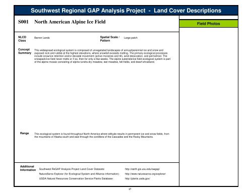
S001<br />
North American Alpine Ice Field<br />
Field Photos<br />
NLCD<br />
Class<br />
Barren <strong>Land</strong>s Spatial Scale /<br />
Pattern<br />
Large patch<br />
Concept<br />
Summary<br />
This widespread ecological system is composed of unvegetated landscapes of annual/perennial ice and snow and<br />
exposed rock and rubble at the highest elevations, where snowfall exceeds melting. The primary ecological processes<br />
include snow/ice retention and/or decadal movement (active moraines and till), wind desiccation, and permafrost. The<br />
snowpack/ice field never melts or if so, then for only a few weeks. The alpine substrate/ice field ecological system is part<br />
of the alpine mosaic consisting of alpine tundra dry meadow, wet meadow, fell-fields, and dwarf-shrubland.<br />
Range<br />
This ecological system is found throughout North America where altitude results in permanent ice and snow fields, from<br />
the mountains of Alaska south and east through the cordillera of the Cascades and the Rocky Mountains.<br />
Additional<br />
Information<br />
<strong>Southwest</strong> Re<strong>GAP</strong> <strong>Analysis</strong> <strong>Project</strong> <strong>Land</strong> <strong>Cover</strong> Datasets:<br />
NatureServe Explorer (for Ecological System and Alliance information):<br />
USDA Natural Resources Conservation Service Plants Database:<br />
http://earth.gis.usu.edu/swgap/<br />
http://www.natureserve.org/explorer/<br />
http://plants.usda.gov/<br />
17
<strong>Southwest</strong> <strong>Regional</strong> <strong>GAP</strong> <strong>Analysis</strong> <strong>Project</strong> - <strong>Land</strong>cover <strong>Descriptions</strong><br />
S001<br />
North American Alpine Ice Field<br />
This distribution map represents the Ecological System as it was mapped by the <strong>Southwest</strong> Re<strong>GAP</strong> <strong>Analysis</strong> <strong>Project</strong> for the 5-state region.<br />
The boundaries represent hydrologic units used for delineating Wildlife Habitat Relationships. Ecological Systems that are rare or have very<br />
limited distributions may not be visible on this map. Refer to the list below to identify where this system was mapped.<br />
States where System was<br />
mapped by SWRe<strong>GAP</strong>:<br />
CO,UT<br />
Distribution Map<br />
18